warwick reconnaissance report - massachusetts
TRANSCRIPT

UPPER QUABOAG WATERSHED AND NORTHQUABBIN REGION LANDSCAPE INVENTORY
MASSACHUSETTS HERITAGE LANDSCAPE INVENTORY PROGRAM
Massachusetts Department of Conservation and RecreationCentral Massachusetts Regional Planning Commission
North Quabbin Regional Landscape Partnership
WARWICK RECONNAISSANCE REPORT

PROJECT TEAM
Massachusetts Department of Conservation and RecreationRichard K. Sullivan, Jr, CommissionerJoe Orfant, Director, Bureau of Planning & Resource ProtectionPatrice Kish, Director, Office of Cultural ResourcesWendy Pearl, Director, Historic Landscape Preservation InitiativeJessica Rowcroft, Preservation Planner
Central Massachusetts Regional Planning Commission Adam Burney, Associate Land Use Planner
North Quabbin Regional Landscape PartnershipJay Rasku, Partnership Coordinator
Project ConsultantsDodson Associates, Ltd. Public Archeology Laboratory (PAL)Peter Flinker, Principal Virginia AdamsSarah la Cour, Project Manager Holly HerbsterReid Bertone-Johnson Hillary King
Local Project CoordinatorJim Toth, Selectboard, Cemetery Commission
Local Heritage Landscape ParticipantsTed Cady, Planning BoardLarry Carey Brad Compton, Planning BoardJanet Conover, Cemetery Commission, ZBAChris Duerring, Open Space Committee, Town
Forest CommitteeCal FellowsFreddie Fellows Carol Foote Les Goodman Michael Humphries
Patricia Lemon, Selectboard Scott Maslansky, Open Space CommitteeElaine Reardon Keith Ross, Town Forest CommKasey Rolih, Conservation CommissionChris Ryan Peter Tandy Mary Williamson, Open Space CommitteeJohn Williamson, Planning BoardDavid Young, Town Coordinator
Spring 2008
Deval L. Patrick Governor
Timothy P. Murray Lt. Governor
Ian A. Bowles, Secretary, Executive Office of Energy & Environmental Affairs
Richard K. Sullivan, Jr., Commissioner Department of Conservation & Recreation
COMMONWEALTH OF MASSACHUSETTS • EXECUTIVE OFFICE OF ENERGY & ENVIRONMENTAL AFFAIRS
Department of Conservation and Recreation251 Causeway Street, Suite 600Boston MA 02114-2119617-626-1250 617-626-1351 Faxwww.mass.gov/dcr

CONTENTS
Introduction . . . . . . . . . . . . . . . . . . . . . . . . . . . . . . . . . . . . . . . . . . . . . . . . . . . . . . . . . . . . . . . . . 1
PART I: Heritage Landscape Inventory Local History . . . . . . . . . . . . . . . . . . . . . . . . . . . . . . . . . . . . . . . . . . . . . . . . . . . . . . . . . . 3
Priority Heritage Landscapes . . . . . . . . . . . . . . . . . . . . . . . . . . . . . . . . . . . . . . . . . . . . 5Warwick VillageMount Grace Picnic AreaKidder FallsMoores PondMetacomet-Monadnock TrailMill RuinsAgriculture Land
Warwick Priority Heritage Landscape Map . . . . . . . . . . . . . . . . . . . . . . . . . . . . . . . 24
PART II: Planning for Heritage Landscapes Inventory and Documentation . . . . . . . . . . . . . . . . . . . . . . . . . . . . . . . . . . . . . . . . . . . 25
Planning and Zoning Tools and Techniques . . . . . . . . . . . . . . . . . . . . . . . . . . . . . . . . 26Implementation Strategies . . . . . . . . . . . . . . . . . . . . . . . . . . . . . . . . . . . . . . . . . . . . . . 31
Conclusion . . . . . . . . . . . . . . . . . . . . . . . . . . . . . . . . . . . . . . . . . . . . . . . . . . . . . . . . . . . . . . . . . 33
Appendix A: Heritage Landscapes Identified by Community . . . . . . . . . . . . . . . . . . . . . . . 35Appendix B: Preservation and Planning Tools . . . . . . . . . . . . . . . . . . . . . . . . . . . . . . . . . . . . 41Appendix C: Works Cited . . . . . . . . . . . . . . . . . . . . . . . . . . . . . . . . . . . . . . . . . . . . . . . . . . . . 57


Massachusetts Heritage Landscape Inventory Program �Warwick Reconnaissance Report
INTRODUCTION
Heritage landscapes are special places created by human interaction with the natural environment that help define the character of a community and reflect its past. They are dynamic and evolving, reflect the history of a community and provide a sense of place. They show the natural ecology that influenced land use patterns and often have scenic qualities. This wealth of landscapes is central to each community’s character, yet heritage landscapes are vulnerable and ever changing. For this reason it is important to take the first step toward their preservation by identifying those landscapes that are particularly valued by the community – a favorite local farm, a distinctive neighborhood or mill village, a unique natural feature or an important river corridor.
To this end, the Massachusetts Department of Conservation and Recreation (DCR) and its regional partners, the Central Massachusetts Regional Planning Commission (CMRPC) and the North Quabbin Regional Landscape Partnership (NQRLP), have collaborated to bring the Heritage Landscape Inventory program to fifteen communities in central Massachusetts. The goals of the program are to help communities identify a wide range of landscape resources, particularly those that are significant and unprotected, and to provide communities with strategies for preserving heritage landscapes.
The communities within the Upper Quaboag Watershed and North Quabbin region of central Massachusetts share a common dispersed settlement pattern as well as an early agricultural economy and later shift into manufacturing. Developed along a series of major waterways and their tributaries, including the Millers, Quaboag and Ware Rivers, this region contains vast cultural and historic resources and uncommon natural beauty. The heritage landscapes in the participating communities reflect the agrarian and industrial past while providing recreational and educational opportunities for today. From scenic town commons and natural areas to civic buildings and burial grounds, the heritage landscapes within the region collectively tell the story of their varied and often turbulent, history.
Upper Quaboag Watershed and North Quabbin Region Heritage Landscape Inventory project area
� Massachusetts Heritage Landscape Inventory Program Warwick Reconnaissance Report
Methodology
The methodology for the Heritage Landscape Inventory program was developed in a pilot project conducted in southeast Massachusetts. It is outlined in the DCR publication Reading the Land, which has provided guidance for the program since its inception. In summary, each community organized a heritage landscape identification meeting during which residents and town officials identify and prioritize the landscapes that embody the community’s character and its history. This meeting is followed by a fieldwork session including the consulting team, accompanied by interested community members. The final product for each community is an individualized Heritage Landscape Reconnaissance Report. This report outlines the community’s landscape history, discusses broader land planning issues identified by the community, describes the priority heritage landscapes and issues associated with them and concludes with preservation recommendations.

Massachusetts Heritage Landscape Inventory Program �Warwick Reconnaissance Report
PART I: HERITAGE LANDSCAPE INVENTORY
LOCAL HISTORY
Warwick’s rugged terrain has played an enormous role in its growth and history. The landscape of hills and valleys, webbed with numerous brooks was likely a hunting and fishing ground for small bands of Native Americans from the Squakeag (later known as Northfield) settlement. Later on, colonial residents of Northfield may have also depended on the natural resources of Warwick, although the difficulty of road development through the area and threat of Indian attacks kept Warwick unsettled longer than surrounding areas.
Warwick was originally given to a group of Canadian Expedition veterans through a land grant in �7�5, and was called Gardner’s or Roxbury Canada. Families began moving into town by the 1740s and the first meetinghouse was built in 1756. Although incorporated in 1763, earlier residents built a corn mill on the Black Brook near Richards Reservoir. The mill stones from this mill, run by David Ayres, currently sit in the town center in front of the Warwick Public Library.
In 1765, the town consisted of 36 dispersed homesteads and 191 residents and the townspeople generally made a living through livestock and lumbering. Saw and grist mills were built on the area’s plentiful system of waterways, and by 1776 the population had reached over 750 residents. By the late �8th century, a stagecoach route was established through Warwick, making it a stop for travelers from Worcester to Brattleboro and the construction of the 5th Massachusetts Turnpike around �800 improved these roadways. Soon after the road improvements, the Cobb House (�8�8)
was appointed as the town’s post office and the Warwick Inn served as a stagecoach stop at the village center. Both of these landmarks continue to make up the historic fabric of the village.
Once the Boston to Worcester railroad opened in the mid-19th century, the Turnpike became a busier route as hope built for an additional rail line to run through Warwick from Athol to Brattleboro. Surveys were taken throughout town but unfortunately plans fell through for Warwick and the line was built in Orange and Northfield. The loss of the railways to nearby towns drew many residents and industries away from Warwick.
1894 USGS Map - http://docs.unh.edu/nhtopos/nhtopos.htm

� Massachusetts Heritage Landscape Inventory Program Warwick Reconnaissance Report
The natural beauty of the topography and waterways of Warwick brought modest resort development in the 20th century. However, these same resources have made it difficult for development and brought about numerous conservation efforts. The Commonwealth of Massachusetts owns and manages 5�% of the land in town. Other protected lands are owned and managed by the Mount Grace Land Conservation Trust and the New England Forestry Foundation; and a number of private citizens have placed conservation restrictions on their properties, particularly during the “Tully Initiative” - a conservation initiative sponsored by the Executive Office of Enviromental Affairs in �000-�00�.
The �000 census shows the town having 750 residents. Warwick attracts many regional recreational enthusiasts to Mount Grace and the Metacomet-Monadnock Trail, and charms all with its rural beauty. Along with the tourist economy, local businesses include Humphries Woodworking and Chase Hill Farm, a family owned organic dairy farm. The townspeople are active in preserving their rural way of life and hope to preserve its history for generations to come. The identification of priority landscapes that reflect the town’s early industrial heritage and its unique natural beauty and resources is critical to an overall preservation strategy. It is these heritage landscapes that ‘tell the story’ of Warwick and its varied past.
Massachusetts Heritage Landscape Inventory Program 5Warwick Reconnaissance Report
PRIORITY HERITAGE LANDSCAPES
The Upper Quaboag Watershed and North Quabbin Region is experiencing significant growth pressure and will need to determine how it will affect the rural character of its communities and the heritage landscapes that the communities find valuable. In the Warwick public identification meeting, participants identified priority landscapes in town that define the heritage of the community. These heritage landscapes provide a cross section of the types of landscapes that contributed to the historical development of the town and together tell the story of Warwick’s past. The following text describes the unique value that each of these landscapes provides to the community and a set of recommendations for its preservation and protection.
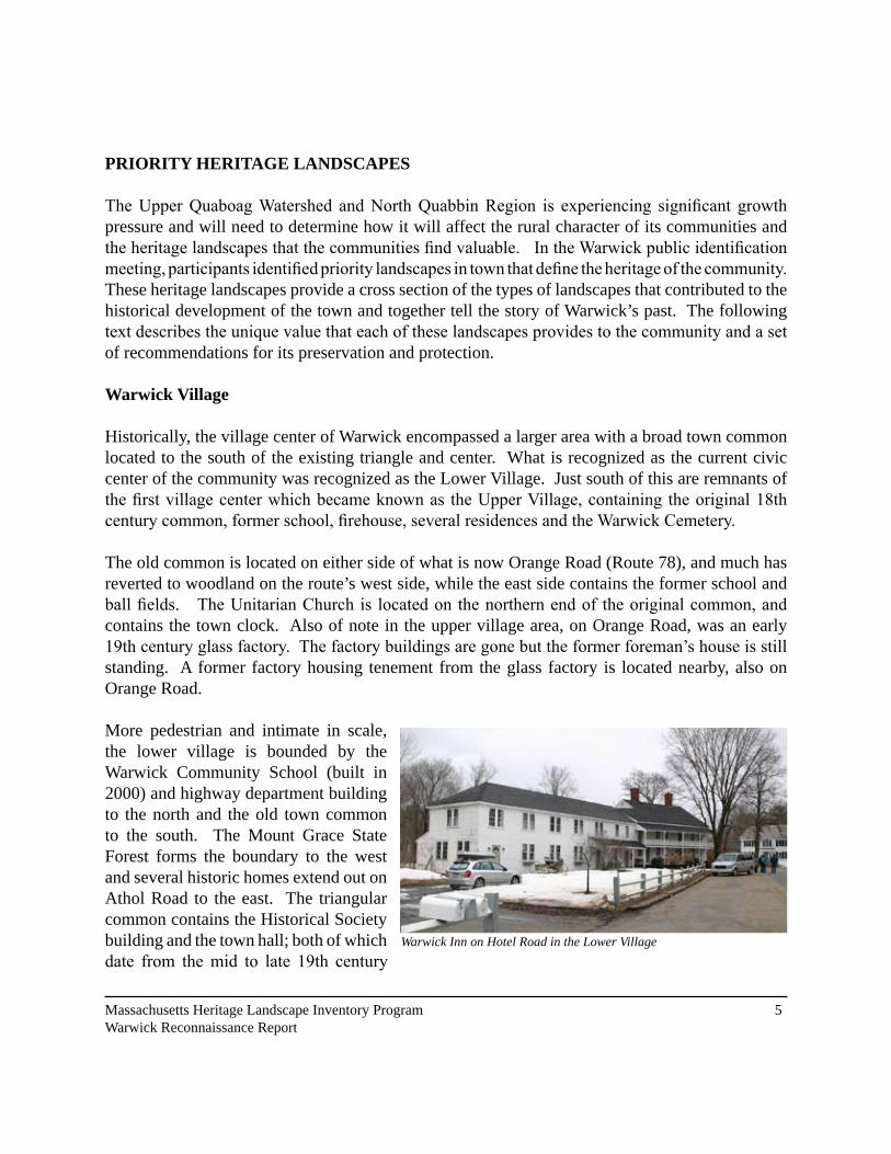
Warwick Village
Historically, the village center of Warwick encompassed a larger area with a broad town common located to the south of the existing triangle and center. What is recognized as the current civic center of the community was recognized as the Lower Village. Just south of this are remnants of the first village center which became known as the Upper Village, containing the original 18th century common, former school, firehouse, several residences and the Warwick Cemetery.
The old common is located on either side of what is now Orange Road (Route 78), and much has reverted to woodland on the route’s west side, while the east side contains the former school and ball fields. The Unitarian Church is located on the northern end of the original common, and contains the town clock. Also of note in the upper village area, on Orange Road, was an early 19th century glass factory. The factory buildings are gone but the former foreman’s house is still standing. A former factory housing tenement from the glass factory is located nearby, also on Orange Road.
More pedestrian and intimate in scale, the lower village is bounded by the Warwick Community School (built in �000) and highway department building to the north and the old town common to the south. The Mount Grace State Forest forms the boundary to the west and several historic homes extend out on Athol Road to the east. The triangular common contains the Historical Society building and the town hall; both of which date from the mid to late 19th century
Warwick Inn on Hotel Road in the Lower Village

6 Massachusetts Heritage Landscape Inventory Program Warwick Reconnaissance Report
and contribute to the character of the village. The common is also lined with a variety of other civic and community buildings.
On Hotel Road is the former Baptist Meeting House that is now the town library. This 19th century building has a recent addition that is historically compatible and the historic town fountain is located in front, fed with water from a spring on Mount Grace. Water from the spring also feeds the library, Historical Society building and Town Hall. A directional post from the�800s is located across from the Town Hall
on Athol Road. This was restored two years ago and serves as a reminder of historic wayfinding structures and informational signage.
Located at the intersection of Athol and Hotel Roads is what was known as the Warwick Inn which currently contains three residences but was historically a tavern and stagecoach stop when the toll road went through town. Residences on either side of Athol Road date from the mid 19th century. Further along Athol Road are the Cobb House, which was the former Post Office and store, and the Metcalf Chapel (also known as the Preserved Smith House.) The residences on the west side of Route 78 at the center were all built in the mid-19th century.
Just north of the center, between Winchester Road and the Mount Grace State Forest, is a significant agricultural
The Upper Village area along Orange Road
1836 Unitarian Church at Upper Village

Mount Grace State
Forest
Mount Grace State
Forest
Arthur Iversen C
onservation Area
Warwick Cemetery
1.
3.
6.5.
9.10.
9.
�. Elementary School �. Library �. Historical Society �. Town Hall 5. Warwick Inn 6. Cobb Post Office 7. Metcalf Chapel 8. Old School 9. Town Common�0. Fire House
Upper Village
Lower Village
2.4.
7.
8.
HASTINGS PO
ND
ROAD

8 Massachusetts Heritage Landscape Inventory Program Warwick Reconnaissance Report
landscape that includes several early farm buildings, associated agricultural fields, a fire pond and stunning views to Mount Grace. This is a uniquely large, open parcel located adjacent to the village center and helps to maintain the rural feel of the community.
Opportunities• 19th century village center retains much of it’s architecture and historic character• The two villages connected by the former common provides a unique interpretive
opportunity• The Unitarian Church is used very little, but is in a prime location and contains the historic
town clock
Issues• Several buildings (including the parsonage of the historic Unitarian Church) around the
lower village common are vacant and in need of restoration • The lower village center and common area are not currently under any form of protection
nor are any of the individual buildings that contribute to its character
Recommendations�. Establish a Local Historic District (LHD) Committee and explore the feasibility of
establishing the Village Center as an LHD. An LHD would make town buildings eligible to apply for the Massachusetts Preservation Program Fund (MPPF). (see page �0 for more about LHDs)
�. Investigate eligibility of the Village Center as a National Register Historic District (NRHD), this listing would make town buildings eligible to apply for MPPF funds and income producing properties eligible to apply for investment tax credits.

Massachusetts Heritage Landscape Inventory Program 9Warwick Reconnaissance Report
Mount Grace Picnic Area
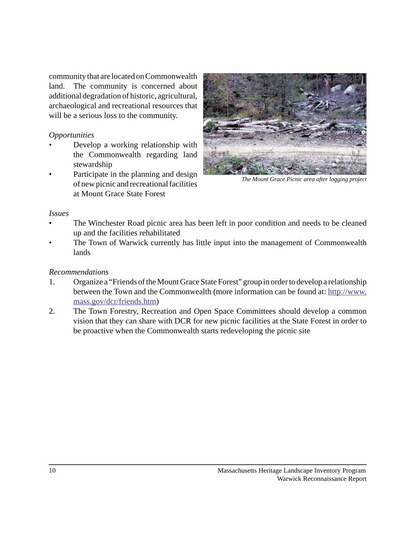
Located on Winchester Road at the eastern base of the mountain, the Mount Grace Picnic Area was a favorite spot for picnics and passive recreation. As part of the Mount Grace State Forest, the picnic area is owned and maintained by the MA Department of Conservation and Recreation (DCR). This area is identified on their maps of the reservation and also indicates connections to trails around the base of the mountain and regional trail systems. In the 1974 Natural Resources Program of the Town of Warwick- Inventory of Sites with Natural Resource Potential, prepared by the Franklin County Natural Resources Technical Team, the picnic area is described as having 55 picnic tables, 22 fireplaces, a wading pool and a playfield located in a white pine grove.
By 2005-2006, DCR initiated a logging project in this area that has significantly impacted the picnic area and ability for the public to use and enjoy the area. Around this time, there were significantly less amenities available at the picnic area, with less than twenty of the original fireplaces, and a handful of newer picnic tables remaining.
With the Commonwealth of Massachusetts owning 5�% of the land area in town, it is understandable that there may be issues with management and maintenance. However, the loss of the picnic area has been a particularly difficult issue for the community and there is concern about the Commonwealth’s land management policies in the future. There are vast heritage landscape resources within the
Image of the Picnic Area from 1936 (top). Members of the community clean up the wading pool in the late 1990s (below).
Photos provided by Larry Carey.
�0 Massachusetts Heritage Landscape Inventory Program Warwick Reconnaissance Report
community that are located on Commonwealth land. The community is concerned about additional degradation of historic, agricultural, archaeological and recreational resources that will be a serious loss to the community.
Opportunities• Develop a working relationship with
the Commonwealth regarding land stewardship
• Participate in the planning and design of new picnic and recreational facilities at Mount Grace State Forest
Issues• The Winchester Road picnic area has been left in poor condition and needs to be cleaned
up and the facilities rehabilitated• The Town of Warwick currently has little input into the management of Commonwealth
lands
Recommendations�. Organize a “Friends of the Mount Grace State Forest” group in order to develop a relationship
between the Town and the Commonwealth (more information can be found at: http://www.mass.gov/dcr/friends.htm)
�. The Town Forestry, Recreation and Open Space Committees should develop a common vision that they can share with DCR for new picnic facilities at the State Forest in order to be proactive when the Commonwealth starts redeveloping the picnic site
The Mount Grace Picnic area after logging project
Approximate M- M Trail

*Kidder Falls
*Mt. Grace Picnic Area
Mount Grace State
Forest
Arthur Iversen
Conservation A
rea
Warwick State Forest
Warwick State Forest
Warwick State
Forest
Approximate M- M Trail
HASTINGS PO
ND ROAD

�� Massachusetts Heritage Landscape Inventory Program Warwick Reconnaissance Report
Kidder Falls
Beloved by Warwick’s “old-timers”, this site contains two cascading waterfalls that drop 50 feet in height over �50 feet and as one of the few waterfalls/cascades in town, this is a unique landscape feature that was created as part of Warwick’s “small mill” industrial past. Located on Kidder Brook, approximately �00 yards from Old Winchester Road, the Kidder Falls site was identified in the 1974 Franklin County Natural Resources Program - Inventory of Sites with Natural Resource Potential study. The brook has little flow from the middle to late summer but supports native brook trout and is an excellent fishing area. The land on which the falls and its access trail are located is privately owned and the owner does not allow unauthorized public access. Although the existing trail to the falls has a certain charm, the current owners are not interested in providing public access.
Opportunities• Unique water feature that is beloved by many in the community• The Metacomet-Monadnock Trail passes nearby
Issues• Falls are located on private land• Kidder Brook and Kidder Falls are currently unprotected
Recommendations�. The town should develop a good relationship with the property owner and encourage them
to discuss any sale plans of the property with the town and/or the Commonwealth if they ever decide to put it on the market.
2. Research the potential for the acquisition of a trail easement through the private land
Kidder Falls - Photo by Larry Carey

Massachusetts Heritage Landscape Inventory Program ��Warwick Reconnaissance Report
Moores Pond
Located in central Warwick, Moores Pond is a privately owned water body covering approximately �� acres. The southern portion of the pond’s shoreline is lined with early �0th century cottages.
Originally they were primarily seasonal but recently a number of them have been moddernized and converted to year-round use.
There is a beach on the south side located on private land, but the land owner graciously allows public access for recreational activities. A boat ramp, located on the northwestern shore of the pond on Wendell Road, was recently acquired by the Public Access Board. Moores Pond is a popular summer destination and attraction for Warwick residents.
Moores Pond is also a significant hydrological, ecological and scenic resource in the community. There are approximately �0 acres of marsh at the north end of the pond, where Grace Brook enters, and the town has identified it as an important waterfowl resting and feeding area. The pond contains a natural population of largemouth bass, chain pickerel, yellow perch, bluegill sunfish, bullhead & golden shiner and Mass Fish & Wildlife stocks it annually with trout. In addition, Darling Brook runs out of Moores Pond to the south providing a critical link in the town’s broader
hydrological and ecological systems. Darling Brook has also been identified as a “biodiversity core habitat area” by the Massachusetts Natural Heritage and Endangered Species Program.
From the pond there are stunning views to the north of Mount Grace and Little Mount Grace as well as to the Barber Hill Ridge running above the eastern side of the pond. These distinguished views enhance the charm of the Pond and contribute to its significant scenic character. The Barber Hill Ridge area also contains additional cultural and historic resources including caves and historic house foundations located along the old roadway that connects the Upper Village with Moores pond.
View looking east across Moores Pond toward Barber Hill Ridge
View looking north from beach area toward Mt. Grace and Little Mt. Grace
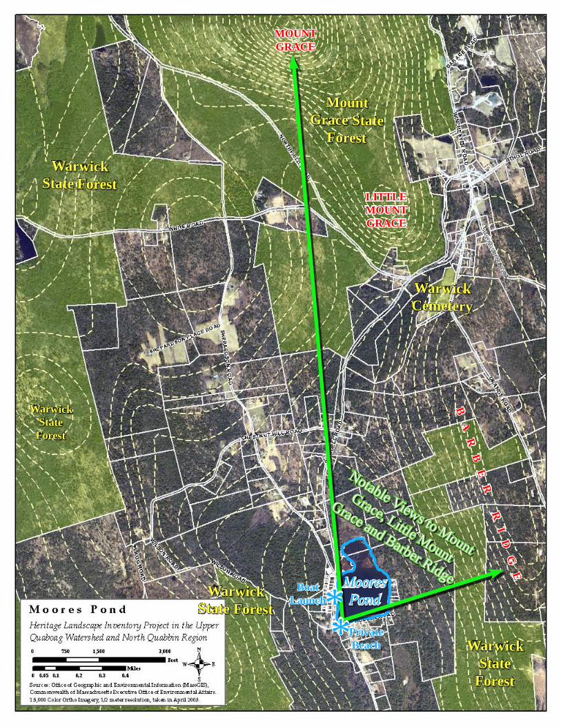
*Boat Launch
*Private Beach
Notable Views to Mount
Grace, Little Mount
Grace and Barber RidgeMoores Pond
Mount Grace State
Forest
Warwick State Forest
Warwick State
Forest
Warwick State Forest
Warwick State
Forest
LITTLE MOUNT GRACE
MOUNT GRACE
BA
RB
ER
R
ID
GE
Warwick Cemetery
HASTINGS PO
ND ROAD

Massachusetts Heritage Landscape Inventory Program �5Warwick Reconnaissance Report
Opportunities• Significant views of Mount Grace and Barber Hill Ridge• Important ecological and hydrological resource for the community• Large tracts of land northeast and east of the pond are owned by DCR and provides a
helpful core and corridor of permanently protected open space that will assist the town as it works toward conserving the exceptional quality of the Moores Pond watershed and its viewshed.
Issues• Beach is privately owned which could lead to loss of access• Large tracts of land surrounding the pond are in private ownership including approximately
850 feet of waterfront along the northeastern corner
Recommendations1. Maintain water quality and wildlife habitat through the adoption of a Wetlands Protection
Bylaw (see page �� for more about Wetland Protection)�. Establish a strong partnership with the owners of the beach parcel to continue public access
and coordination of management and maintenance by formalizing public access through a public easement or actual acquisition by the town.
3. The town could protect the scenic quality of the area by establishing a Scenic Overlay District. (see page �0 for more about scenic protections)
4. Alternatively, the town should work with landowners for the acquisition of Conservation Restrictions to protect the viewshed (see page 29 for more about CRs)

16 Massachusetts Heritage Landscape Inventory Program Warwick Reconnaissance Report
Metacomet-Monadnock Trail
Originating in Connecticut and extending to Mount Monadnock in southern New Hampshire, the Metacomet-Monadnock (M-M) Trail runs for approximately 16 miles through the Town of Warwick (Sections �7 and �8, described at: http://www.amcberkshire.org). Most of the M-M Trail is located on Commonwealth owned land within the Mount Grace State Forest and the Warwick State Forest. Trailheads exist at Northfield Road, Bass Road, Old Winchester Road, Richmond Road, and Winchester Road. In the Mount Grace State Forest, the trail intersects with the “Around the Mountain” trail that encircles Mount Grace and crosses the top of the mountain at the Fire Tower, which offers distinctive views of the surrounding countryside. At the current time, however, these views are visible only if one climbs the Fire Tower, due to the density of the forest cover at the top of the mountain. From Mount Grace the M-M Trail extends into Warwick State Forest and runs along the shoreline of Richards Reservoir.
Although located primarily on Commonwealth land in Warwick, the trail is managed and maintained by the Appalachian Mountain Club. Essentially a hiking trail, All Terrain Vehicles (ATV’s) are not allowed on the M-M Trail although snowmobiles are allowed seasonal limited access. ATV use tends to cause trail
erosion and damage to tree roots and ecological systems but is hard to enforce on this length of trail. Motorized uses versus non-motorized travelers sharing narrow trails can create conflicts.
M-M Trail (top) and view from the trail atop Mount Grace (below). The white painted blaze shown on the tree in the top photo is a standard marking along the trail. The markings are about the size of a dollar bill and at eye level per the Metacomet-Monadnock Trail Guide. Photos by Jim Toth.

Massachusetts Heritage Landscape Inventory Program �7Warwick Reconnaissance Report
Current estimated M-M Trail.
Opportunities• Multi-state regional trail with several access points in Warwick• Primarily located on Commonwealth land
Issues• There are varying levels of management due to the diversity of owners and organizations
involved• Occasional conflicts in use
Recommendations�. Work with the Appalachian Mountain Club to assist with trail management and
maintenance
M- M
T rai l
Mount Grace
Warwick Village
NO
RTH
FIELD
NEW HAMPSHIRE
RO
YALSTO
N

�8 Massachusetts Heritage Landscape Inventory Program Warwick Reconnaissance Report
Mill Ruins
According to Charles Morse in Warwick Massachusetts: Biography of a Town, there were approximately �� mills in Town prior to �8�5. Primarily grist and saw mills, there were also a couple of brickyards, several tanneries and a glass factory scattered throughout the town. From the turn of the19th century until approximately 1825, Warwick reached its peak of industrial activity. This early industrial heritage is still distinguishable in the many mill remnants along the brooks
in town.
Of those mill ruins that remain, there are several along Grace Brook including the Williams Melzar Mill Site (in operation from �8�0-�5) at the intersection of Wendell and Northfield Roads. Located on private land, this site contains several stone terraces and the former millrace that are still distinguishable. There are also several stone foundations and mill remnants located on Chestnut Hill Road along Grace Brook as well as several other dam ruins along the brook further up Wendell Road.
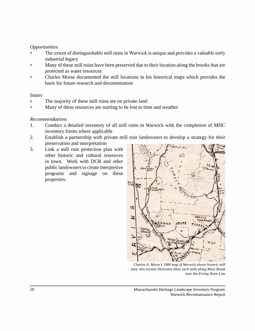
Several mills were also located along the Moss and Black Brooks, and other brooks in town, as documented in Charles Morse’s 1980 map of early Warwick. The remains of these have not been thoroughly documented but are mentioned in local lore and may include some of the following:• Bass Mill complex ruins at swamp, Northfield Road• Ayers Mill site off Richmond Road below Richards Reservoir• Locke’s saw mill south of Moores Pond• Shearman saw mill and grist mill on Kidder Brook, Old Winchester Road• Asa Robbins mill site at Kidder Falls, upstream of the Shearman saw mill site.• � Rich Brothers mill sites at the east end of Steven’s Pond, SE end of Gales Pond, and
Mirey Brook• David Gale grist mill, Gale Brook • Conant saw and grist mills, approx �.5 mi from Gale mill on Gale Brook
Site of Melzar Williams’ early 19th century clothier mill on Grace Brook; several stone terraces and mill race remain

** *
*** ****
*** *
*
* *Denotes Historic Industrial Area
�0 Massachusetts Heritage Landscape Inventory Program Warwick Reconnaissance Report
Opportunities• The extent of distinguishable mill ruins in Warwick is unique and provides a valuable early
industrial legacy• Many of these mill ruins have been preserved due to their location along the brooks that are
protected as water resources • Charles Morse documented the mill locations in his historical maps which provides the
basis for future research and documentation
Issues• The majority of these mill ruins are on private land• Many of these resources are starting to be lost to time and weather
Recommendations�. Conduct a detailed inventory of all mill ruins in Warwick with the completion of MHC
inventory forms where applicable �. Establish a partnership with private mill ruin landowners to develop a strategy for their
preservation and interpretation�. Link a mill ruin protection plan with
other historic and cultural resources in town. Work with DCR and other public landowners to create interpretive programs and signage on these properties.
Charles A. Morse’s 1980 map of Warwick shows historic mill sites; this section illustrates three such mills along Moss Brook
near the Erving Town Line

Massachusetts Heritage Landscape Inventory Program ��Warwick Reconnaissance Report
Agricultural Land
There are several large tracts of agricultural land in Warwick that retain the early agrarian character of the community. With many former farm fields reverting to forestland, these remaining open landscapes represent an important part of the town’s heritage. Several of these agricultural areas are still actively farmed aand maintain significant scenic value. Foremost among these areas are Shepardson Hill, Flower Hill, North Warwick, Mayo Corners and Chase Hill Road.
Shepardson Hill contains large open farm fields that slope to the south and provides stunning views of distant hills south of town. This land is actively hayed which keeps the fields open and preserves the view. The situation is similar on Flower Hill where open fields provide a particularly dramatic view north to the mountains of southern New Hampshire as well as east toward Mount Grace. The scenic character of these areas are vulnerable to being lost if the fields revert to forest.
In North Warwick there is a collection of historic farmhouses and fields along Winchester Road
beginning near Flower Hill Road and continuing north to the New Hampshire border. This area was a former lakebed with a high concentration of Prime Farmland Soils, as identified in the 2002 Open Space and Recreation Plan, which make it valuable as farmland. High scenic quality and significant views to Mount Grace enhance the significance of this agricultural heritage landscape. It has also been noted by residents that there may be colonial ruins within these farmsteads that provide an additional level of historic value. The Chase Hill Farm, located on Chase Hill Road between Athol and Royalston Roads provides a valuable agricultural corridor in town with great scenic and cultural importance. Still an active farm, Chase Hill has been permanently protected through the Agricultural Preservation Restriction Program (APR). There are several additional parcels adjacent to the Chase Hill Farm that provide contextual landscape value as well as views to Mount Monadnock in New Hampshire.
Agricultural connections remain adjacent to the Village Center and is an important feature of its character
View of Mayo Corners and toward Mount Grace from Hastings Heights Road

�� Massachusetts Heritage Landscape Inventory Program Warwick Reconnaissance Report
Due to the community’s high scenic quality, the town voted in 1982 to accept the MA Scenic Roads Act and designate all roads in town as scenic with the exception of Route 78. This has allowed the roads running through these significant agricultural areas to retain their stone walls, streets trees and overall scenic and historic character.
Opportunities• Many of these agricultural areas have
remained open because they are actively farmed
• These areas represent large, undeveloped tracts of agricultural land in an otherwise forested community
• According to the �00� Open Space Plan, Warwick contains approximately 360 acres of agricultural land in the Chapter 61A Program
Issues• Some of the former agricultural land in
town is being lost to forest succession • All of the farmland identified is in private ownership and only Chase Hill Farm is under
permanent protection
Recommendations�. Work with the private landowners to place additional lands in the Agricultural Preservation
Restriction Program (see page �8 for more about APRs)�. Create an Agricultural Preservation Overlay Zone for Shepardson Hill, Flower Hill and
North Warwick agricultural areas (see page �8 for more about this zone)3. The town should develop a Chapter 61 Policy that prioritizes parcels currently in the
program. Place a high priority on open fields throughout town. The Town should enact its right-of-first-refusal to purchase Conservation Restrictions on these parcels if they become available. (see page 29 for more about Chapter 61 Policy)
�. Form a local Agricultural Commission and adopt a Right-to-Farm bylaw for the town (see page �0 for more about the Right-to-Farm). The new commission should conduct outreach to explain Chapter 61 to 61A transfers for historic field restoration.
Southeasterly views from Shepardson Farm
Views toward New Hampshire on Flower Hill Road

North Warwick
Agricultural Area
Flower Hill Agricultural
Area
Shepardson Fields
Chase Hill
Farm

Warwick VillageMoores Pond
Agricultural Land
Kidder Falls
Agricultural Land
Mill Ruins
Mill Ruins
Mill Ruins
Mill Ruins
Mill Ruins
Mill Ruins
Mill Ruins
Mill Ruins
Mill Ruins
Mill Ruins
Mill Ruins
Mill Ruins
Mill Ruins
Mill Ruins
Agricultural Land
Agricultural Land
Mount Grace Picnic Area
ORANGE
ERVING
NORTHFIELD
ROYALSTON
WENDELL
Priority Heritage Landscapes
Priority Heritage Landscapes Overlap with Permanently Protected Open Space
Permanently Protected Open Space
W a r w i c k , M a s s a c h u s e t t s
P r i o r i t y H e r i t a g e L a n d s c a p e s
Prepared for: Massachusetts Department of Conservation and Recreation, Heritage LandscapeInventory Project in the Upper Quaboag Watershed and North Quabbin Region
Prepared by: Dodson Associates, Ltd., Landscape Architects and PlannersAshfield, Massachusetts
25 June 2008 .0 1 2 3 40.5Miles
For Planning Purposes Only
"Office of Geographic and Environmental Information (MassGIS), Commonwealth of Massachusetts Executive Office of Environmental Affairs"MassGIS 2005 Orthophotos

Massachusetts Heritage Landscape Inventory Program �5Warwick Reconnaissance Report
As our communities undergo rapid land use changes, heritage landscapes are particularly threatened because they are often taken for granted. There is a broad variety of resources that communities can call upon to protect these irreplaceable landscapes. What follows is a review of the tools that Warwick already has in place, as well as a number of recommended actions for the future. The measures already in place for Warwick provide a strong foundation for heritage landscape preservation, but additional measures have been identified in the following text that will aid the development of a holistic preservation planning strategy. Appendix B includes extended descriptions of preservation measures. These tools should be considered in combination with those recommendations made in Part I for Warwick’s priority landscapes.
INVENTORY AND DOCUMENTATION
1. Massachusetts Historical Commission Records
We cannot advocate for something until we clearly identify it – in this case, the physical characteristics and historical development of the town’s historic and archeological resources. The necessary first step is to record information about the resources at the Massachusetts Historical Commission. The Massachusetts Historical Commission’s (MHC) Inventory of Historic and Archaeological Assets is a statewide list that identifies significant historic resources throughout the Commonwealth. In order to be included in the inventory, a property must be documented on an MHC inventory form, which is then entered into the MHC database. This searchable database, known as the Massachusetts Cultural Resource Information System (MACRIS), is now available online at http://www.sec.state.ma.us/mhc. Information on the specific locations of archaeological sites is not available to the general public in order to protect these sensitive and non-renewable cultural resources.
Current Listings: According to the MHC, Warwick’s inventory documents over 50 cultural resources from the late �8th century to the �0th century ranging from individual homes to civic buildings, grist stones and state forests. Of the heritage landscapes identified by the community as priority resources, the Mount Grace Picnic Area, Warwick Center and many of its surrounding buildings are listed under MACRIS.
There are no documented archaeological sites recorded with MHC.
Recommendations: A comprehensive archaeological survey should be completed for the historic mill sites within the community. Funding assistance for this effort may be available from the MHC Survey and Planning grants, as well as CPA funding.
PART II: PLANNING FOR HERITAGE LANDSCAPES

26 Massachusetts Heritage Landscape Inventory Program Warwick Reconnaissance Report
2. National and State Register Listing
The National Register of Historic Places is the official federal list of districts, sites, buildings, structures and objects that have been determined significant in American history, architecture, archaeology, engineering and culture. Listing brings a number of benefits including recognition, consideration when federally-or state-funded projects may impact the resource, eligibility for tax credits, and qualification for certain grant programs. Resources on the National Register are automatically added to the State Register of Historic Places.
Current Listings: There are no National or local historic districts or sites currently listed in Warwick.
Recommended Listings: The �00� Open Space and Recreation Plan recommended considering “the creation of a Historic District for the center of town” (p. 8-�). Warwick Center, as well as many of its historic buildings, are listed with the MHC. It is recommended that Warwick seek National Registration for the Lower Village as an Historic District, along with additional listings for specific buildings in the village including: Warwick Town Hall (1894), Warwick Inn/Sheomet House/Putnam’s Hotel (�8�8), Warwick Baptist Church/Public Library (�8��) and the Warwick Unitarian Church (1836).
3. Heritage Landscape Inventory List from Local Identification Meeting
Each town involved in the Upper Quaboag Watershed and North Quabbin Region Heritage Landscape Inventory held a local identification meeting to solicit input from a range of community members to identify potential heritage landscapes throughout the town. The lists were prioritized by the community, with help from the consultants, to create a list of five to ten priority areas, which were described in Part I of this report. The complete list of the town’s nearly �00 recognized heritage landscapes is included as Appendix A of this report and provides a sound resource list for future documentation activities and potential funding opportunities. Warwick’s meeting was held on March 5, �008 with �� community members present.
PLANNING AND ZONING TOOLS AND TECHNIQUES
1. Comprehensive, Open Space and other Planning Documents
It is important that Open Space Plans, Comprehensive or Master Plans, and other planning documents address heritage landscapes as vital features of the community, contributing not only to unique sense of place but also to environmental, recreational and economic health.

Massachusetts Heritage Landscape Inventory Program �7Warwick Reconnaissance Report
Current Plans: Warwick created an Open Space and Recreation Plan (OSRP) in 1988 which was updated in �00�. The OSRP provides a valuable source of information for landscape character, significant natural and scenic resources, and a conservation and recreation lands inventory. This inventory includes a table of land ownership and levels of protection including lands in Chapter 61 and under permanent protection. A five-year action plan outlined a number of objectives and steps to take between �00� and �007.
One of the recommended actions of the OSRP was to consider zoning changes to conserve open fields, forestland, scenic vistas and other important open spaces, encourage cottage industries and locally based economic activity, and to protect homes and farms from future adverse land use patterns. The town adopted conservation subdivision regulations in 1988, and revisions and updates were adopted in �008. An ad hoc committee drafted a cell tower policy to guide the Zoning Board of Appeals in issuing a special permit for cell towers.
In November of 1974, a Study Inventory of Sites with Natural Resource Potentials was prepared through the Franklin County’s Town Natural Resources Program. The report provides an inventory of natural, historical and recreational resources within Warwick to serve as a guide for future land use and natural resource development decisions. Three of the Priority Heritage Landscapes documented in this report are mentioned: the Metacomet-Monadnock Trail, remaining agricultural land and Kidder Falls.
Recommended Plans: A comprehensive plan should be developed for the town. It can provide an important frame of reference for land use decisions, and incorporate all of a community’s issues including economic development, housing and transportation into one integrated plan.
2. Zoning Bylaws and Ordinances
Effective and innovative preservation tools exist in the legal and regulatory realm. These range from a wide array of zoning, bylaw and ordinance mechanisms, to incentive programs and owner-generated restrictions on land use.
Current Zoning: The entire town is designated a residential-agricultural zone. The town currently has a Conservation Development Bylaw and employs Site Plan Review. Warwick has adopted the Massachusetts Scenic Roads Act, General Laws Chapter �0, Section �5C, and designated all roads in town, (with the exception of Route 78,) as scenic.

�8 Massachusetts Heritage Landscape Inventory Program Warwick Reconnaissance Report
Additional Planning and Zoning Tools and Techniques for Warwick’s landscapes:
Agricultural Preservation Restrictions (APR)The Agricultural Preservation Restriction (APR) Program is a voluntary program managed by the Massachusetts Department of Agricultural Resources. It is intended to provide a “non-development” alternative to farmers and other owners of “prime” and “state important” agricultural land. When faced with the inability to actively farm and rising tax assessments, this offers the farmer the opportunity to retain the property rather than sell it for development. The State purchased a permanent deed restriction on the property for the difference between fair market value and agricultural value. The deed restriction would preclude any use of the property that will negatively impact its agricultural viability. Chase Hill Farm and Bower’s Farm at Mayo Corners are currently under APR. This program may be able to assist additional land owners in preserving important agricultural landscapes throughout Warwick.
Agricultural Preservation ZoningAn agricultural preservation overlay zone can be created that will promote and protect the practice of farming. This can help to preserve lands on which farming is most viable, lands that maintain an adequate agricultural base in town and areas that preserve the culture and landscape of farming. This can be accomplished in several ways including requiring all new large-scale residential development to be clustered on areas least suitable for agriculture and away from farms and views. An agricultural preservation bylaw can also use the site plan review process to require dedicated open space to remain as farmland and include that new development be located on least suitable soils for agriculture and be integrated into the existing landscape.
Archaeological Resource ProtectionArchaeological sites are non-renewable cultural resources that can be permanently altered or destroyed through unauthorized digging, artifact collection, and development. Protection of archaeological sites can occur through a number of different strategies and mechanisms. An important first step is the development of a town-wide archaeological resource protection plan. Based on a professional reconnaissance survey of resources in the community, this plan would recommend steps for their preservation. Options for protection include acquisition, preservation restrictions, site plan review, an archaeological review bylaw and public education. Reasonable thresholds for local review of archaeological resources should be developed in consultation with the Massachusetts Historical Commission and interested groups such as the Massachusetts Commission on Indian Affairs.

Massachusetts Heritage Landscape Inventory Program 29Warwick Reconnaissance Report
Community Preservation ActBy enabling legislation created in �000, the Community Preservation Act (CPA) helps communities provide funds for the preservation of open space and historic resources and the creation of affordable housing and recreational facilities. The funds are raised through a property tax surcharge ranging from 0.5% to �% and are administered by a local Community Preservation Committee. A minimum of 10% of the annual revenues must be used for each of the three core areas: acquisition and preservation of open space, acquisition and preservation of historic buildings and landscapes and creation and support of affordable housing. The remaining 70% can be used for any combination of the above uses and for recreational uses.
Conservation Restrictions (CR)A permanent deed restriction between a landowner and a holder - usually a public agency or a private land trust; whereby the grantor agrees to limit the use of his/her property for the purpose of protecting certain conservation values in exchange for tax benefits. The Executive Office of Energy and Environmental Affairs’s Division of Conservation Services provides assistance to landowners, municipalities, and land trusts regarding conservation restrictions and has produced The Massachusetts Conservation Restriction Handbook as a guide to drafting conservation restrictions. CRs could help protect the viewshed of the Moores Pond area.
Chapter 61 PolicyMassachusetts General Laws Chapter 61 was created in the 1970s when many farmers and forestland owners were forced to sell their land due to rising property values and taxes. The legislation became known as the Forestland Act but was quickly followed by Chapter 61A, the Farmland Assessment Act and 61B, the Open Space Act. This new legislation required towns to reduce assessments on farm, forest and open space lands as long as the owners made a commitment to keep their land in that use.
A major provision of this law allows the town the right of first refusal on these lands if the lands are to be sold for residential, commercial or industrial purposes. This provision provides the town with the opportunity to match a fair market value offer for the property. Warwick should review the Chapter 61 land in town and develop a policy for determining priorities for acquisition if land becomes available. Adoption of a Chapter 61 Policy would outline a response process for the town to follow when these lands come out of the program. This may include a requirement for the selectboard to collaborate with other town boards, conservation groups and other interested parties, and hold a public meeting. The Town should also maintain a good working relationship with the Mount Grace Land Conservation Trust as they may be able to offer some guidance with these preparations. Changes to the programs in 2006, allows landowners to switch their land from
�0 Massachusetts Heritage Landscape Inventory Program Warwick Reconnaissance Report
enrollment under one chapter to another without penalty. This is a great tool for Warwick to utilize in restoring historic fields that have been lost to forest succession.
For more information about the Chapter 61 Program and to see a sample Chapter 61 Policy, please see the Mount Grace Land Conservation Trust website (http://mountgrace.org/), to download their Chapter 61 Handbook. MassWoods (http://www.masswoods.net) also contains good information about the program.
Demolition Delay BylawDemolition delay bylaws provide a time period in which towns can consider alternatives to demolition of historic buildings and structures. The local historical commission should work with MHC staff to develop a bylaw that would best suit the town and should work with other town groups to publicize the advantages of a demolition delay bylaw to the community. Most demolition delay bylaws apply to structures that were built more than 50 years ago. The most common delay of demolition is six months; however many communities are finding that a one-year delay is more effective. A demolition delay bylaw requires a majority vote of Town Meeting.
Local Historic Districts (LHD) Local Historic Districts are designated through the adoption of a local ordinance that recognizes special areas within a community where the distinctive characteristics of buildings and places are preserved and protected by the designation. These districts are the strongest form of protection for the preservation of historic resources. They are adopted by a �/� vote of Town Meeting and are administered by a district commission appointed by the Board of Selectmen. Warwick Village could be a good candidate for an LHD.
Right to Farm BylawA Right to Farm Bylaw asserts the rights of farmers to pursue agricultural activities, provides community support for farming activities and requires dispute resolution so that abutters cannot make nuisance claims. Agricultural landscapes are widely considered to be significant heritage landscapes for which there is constant concern of potential development. This bylaw serves to help active farmers remain just that - active. Scenic Vista Protection BylawThis is a preservation planning tool that seeks to protect the scenic qualities of mountains, hills and rolling terrain by requiring additional design criteria for new construction in these visually sensitive areas. A scenic vista protection bylaw can be created in the form of a scenic overlay district or address specific portions of a viewshed such as above a designated elevation and visible from public areas. A scenic protection bylaw is generally administered through site plan review

Massachusetts Heritage Landscape Inventory Program ��Warwick Reconnaissance Report
and the development application process. A scenic overlay district could be adopted to protect the Moores Pond area.
Wetlands Protection Act and BylawsThe Wetlands Protection Act (MGL Chapter 131, Section 40) protects wetlands by requiring a careful review by local conservation commissions of proposed work that may alter wetlands. The law also protects floodplains, riverfront areas, land under water bodies, waterways, salt ponds, fish runs and the ocean. Communities may also adopt their own Wetlands Protection Bylaw, providing stricter regulations than those mandated in Chapter ���.
IMPLEMENTATION STRATEGIES
Outreach, Education and InterpretationIn order to create a community of advocates, we need to raise public awareness and broaden the base of support. This includes developing opportunities to learn about and celebrate the places and history of the town, as well as to care for them.
CollaborationProtecting community character, respecting history, and promoting smart growth are interrelated concerns that impact heritage landscapes and require collaboration across a broad spectrum of the community. This includes communication among town boards and departments, as well as public-private partnerships.
Technical AssistanceRegulations and creative solutions for heritage landscapes are constantly changing and emerging. Public and private agencies offer technical assistance with the many issues to be addressed, including DCR, MHC, and the Franklin Regional Council of Governments.
Funding OpportunitiesFunding rarely comes from a single source, more often depending on collaborative underwriting by private, municipal, and regional sources. Each town also has a variety of funding sources that are locally-based and sometimes site-specific.
A list outlining options for the above strategies can be found in Appendix B.

Massachusetts Heritage Landscape Inventory Program ��Warwick Reconnaissance Report
CONCLUSION
The Heritage Landscape Reconnaissance Report for Warwick provides an initial preservation-planning document that identifies priority heritage landscapes and discusses strategies for their long-term protection. As identified in the local meeting, Warwick contains a rich diversity of heritage landscape types ranging from a large collection of former mill sites to active farms, regionally significant natural and recreational resources and its historic village center. Warwick has been fortunate to retain a variety of heritage landscapes that continue to define its historic fabric and cultural identity. Collectively, these resources provide snapshots through history of the patterns of settlement and the early agricultural and industrial heritage that is still clearly visible in the buildings and landscapes of Warwick.
This Report provides a starting point for preservation strategies but the heritage landscapes identified, especially the priority landscapes, will need additional research and documentation including the preparation of additional MHC inventory forms. Additional information allows for better consensus building and the support of the broader community in order to successfully implement the recommendations for these landscapes. Ultimately, preservation implementation such as the adoption of potential zoning changes and the solicitation of funds requires a collaboration of local boards and commissions as well as regional and state agencies and non-profit entities.
Distribution of this Reconnaissance Report to various municipal boards and commissions involved in making land use decisions will assist Warwick with an overall strategy for the preservation of its community’s character. The breadth of action steps outlined in this document will require a cooperative effort and a variety of local groups to take the lead on implementation. Recommendations include changes to zoning such as agricultural preservation districts and a wetlands protection bylaw, as well as developing an organized relationship between the town and DCR to assist in the creation of a shared vision for resources on state-owned land. The town should also consider the adoption of the Community Preservation Act and a demolition delay bylaw, both of which could help to preserve the historic character of Warwick Village.
Public outreach that educates the local population regarding the community’s heritage landscape resources is also an important tool for increasing awareness and support for their protection. This report provides an important first step for Warwick’s preservation planning program and can provide the foundation for future historic preservation, conservation and recreation planning activities. The commitment of the citizens of Warwick to their heritage is apparent in the historic landscape character and fabric that makes the town the beautiful and peaceful place that it is.

�� Massachusetts Heritage Landscape Inventory Program Warwick Reconnaissance Report
The project team suggests that the following recommendations be the top three priorities for the Town of Warwick as it works to protect the heritage landscape character of the community:
�. Organize a “Friends of the Mount Grace State Forest” group (more information can be found at: http://www.mass.gov/dcr/friends.htm).
2. Adopt a Chapter 61 Policy.�. Form a Local Historic District Commission to explore the feasibility of establishing a
Local Historic District for Warwick Village.
Massachusetts Heritage Landscape Inventory Program �5Warwick Reconnaissance Report
APPENDIX A: WARWICK HERITAGE LANDSCAPESLandscape Name Landscape Notes
Agricultural
Shepardson Hill Area
hilltop hayfields, providing notable views to the south, and small orchard owned by extended family, remnant of the �00 acre Severance Grant which predates the Roxbury Canada Grant which ultimately became the town of Warwick.
Chase Hill Farmactive organic dairy farm, core of which is in APR, also noted as a residential landscape (two historic homes on east side of road) with notable views
Flower Hill Road Areapart of the 1985-acre Great Farm Grant which also predates the Roxbury Canada Grant which ultimately became the town of Warwick.
Historic Farmsteads throughout townNylander, Manring, Freitag, Hubbard, Humphries Farmsteads all with original historic farm houses, barns, stone walls and open pasture land still intact
Pat Johnson Farmopen pasture with barn and pond at foot of Mt. Grace at edge of village gives an idea of what most of the village farms looked like in the mid to early �800's
Echo Park/Kirk Road/Paul Road Farms Corridor
multiple owners hold contiguous properties which combine to form a notable agricultural corridor of open pasture and hayfields with high visibility from the adjacent Rte 78
Jay/Eckstrand/Cady Farms
multiple owners hold contiguous properties with open pasture, hayfields, and cropland all with prime agricultural soils. This area of north Warwick has the largest concentration of prime soils remaining in current agricultural use. The flat wide fertile stream valley is an anomally in a town of mostly forested steep hills and offers unique scenic views.
Amos Alexander Farm on DCR land, fields are growing in
Note: Highlighted landscapes have been designated “Priority Landscapes” by the town or directly correspond to a Priority Landscape

36 Massachusetts Heritage Landscape Inventory Program Warwick Reconnaissance Report
Note: Highlighted landscapes have been designated “Priority Landscapes” by the town or directly correspond to a Priority Landscape
Archaeological
Ayres Mill Site & Richards Mill Pond At Rum Brook Road, mill site and causeways in danger - on lands owned privately, by town and by DCR
Dam Site on Flower Hill Extension old mill site and cluster of cellar holes
Mill Brook Corridor
dam, causeway,and significant water impoundments both at the headwaters of Mill Brook and at Stevens Swamp as well as along Northfield Road downstream of the Bass Mill site, all on DCR land
Atwood District
former cluster of residences and farms of related families as well as an ancient cemetery in northwest corner of town now abandoned and reverted to forest. Most privately held as large forest parcel. Owner recently has died. Future uncertain.
Bass Mill Site
significant stonework remains including mill foundations and cellars, streamside and hillside retaining walls, portions of dams and penstocks, and bridge abutments, all on DCR land
Warwick Boot Factory formerly stood where Town Hall now stands
Mill Site at Wheeler Reservoir where the name Brush Valley originated due to number of brush mills
Tannery at Chestnut Hill and Wendell RoadsMelzar Williams Mill at Wendell/Northfield RoadsBlack Brook multiple small dam sitesAlexander Farm interesting stone work abounds
Glass Factoryportions of foundations remain as well several associated buildings that are now residences, in Upper Village
Cellar Holes at Smith Road Said to be on DCR and Mount Grace Land Trust land
Mill Site and Cellar Holes on Moss Brook
at Flagg Road on DCR land is the remnants of the circa �8�5 Alexander Blake sawmill that produced the wide boards that are the backs of the pews in the Unitarian Church

Massachusetts Heritage Landscape Inventory Program �7Warwick Reconnaissance Report
Note: Highlighted landscapes have been designated “Priority Landscapes” by the town or directly correspond to a Priority Landscape
BurialAtwood Cemetery family grave site on private propertyKilton Cemetery family grave site on DCR landKelton-Moses Cemetery family grave site on DCR landRich Cemetery family grave siteWarwick Cemetery town ownedWard Cemetery a family gravesite on private property
Civic
Lower Villageincludes Library, fountain, Inn, Store, Town Hall, old post office and Historical Society building; also a noted residential landscape
Ohlson Field on DCR land
Upper Village Includes former town common, old school, fire station, Unitarian Church, historic homes and cemetery
IndustrialHumphries Woodworking largest private employer in townClark's Sawmill inactive
Institutional
First Parish Church
Unitarian church in Upper Village; serves only three to five families, used for annual town memorial day services and occasional weddings, houses the town clock
Library formerly old Baptist Church; in Lower Village
Brotherhood of the Spiritcommune gone since the 1970's located at and around the old Pullen Manor at Shepardson and Chestnut Hill Roads
Metcalf Chapel
former residence of third minister of the town, building moved about �/� mile to its current location, served as the setting for the book Jolly Good Times at Hackamatack. Currently houses Trinitarian Congregational Church.
Old Schoolhouse at Hockanum/Orange Roads

�8 Massachusetts Heritage Landscape Inventory Program Warwick Reconnaissance Report
Note: Highlighted landscapes have been designated “Priority Landscapes” by the town or directly correspond to a Priority Landscape
Military
Historic Fort Site exact whereabouts unknown, rumored near Old Winchester Road and Rum Brook Road
Pomeroy Homestead & Goldsbury and Conant Taverns
on Old Winchester Road (no longer extant), history with Shays Rebellion
CCC CampDCR land, AKA a prison camp, off Richmond Road near Richards Reservoir, used for military training, troops to Afghanistan
NaturalGale Brook & Tributaries includes Rum, Black, Hodge BrooksWabeek Rock large boulder with religious inscription
Stevens Swamp remote scenic pond and wetlands located in large tract of state forest; also an open space/recreation landscape
Mount Grace main landmark of town, highest point around, many trails and much recreation use all on DCR land
Devil's Washbowl plunge pool scour referred to as a glacial pothole on Mt Grace Land Trust land, has difficult access
Glacial Potholes on old Stevens PropertyMoss Brook on DCR landMill Brook much on DCR land
Moores Pondclassic camp lined pond with adjacent wetands and wildlife habitat, notable views of Mt Grace and adjacent ridges; also noted residential landscape
Ohlson Field open field at foot of Mt Grace on DCR land
The Gulf on Mountain Brook has Rte 78 running thru it with DCR land on both sides
Indian Rock Robbins/E. Robbins Roads, near Richards ReservoirIndian PotholesGrace Brook
Barber Hill Vista view of Barber Hill ridge from Hastings Heights Road, Rte 78, and from Moores Pond

Massachusetts Heritage Landscape Inventory Program 39Warwick Reconnaissance Report
Note: Highlighted landscapes have been designated “Priority Landscapes” by the town or directly correspond to a Priority Landscape
Open Space/RecreationMt. Grace Picnic Area Town disappointed with management, on DCR land
Metacomet-Monadnock Trail major regional trail crosses two major roads in town, 16 miles of trails
Kidder Falls(also known as Highland Falls)
picturesque cascade on private property with no public access, also a noted archaeological landscape, also an archaeological landscape: part of Asa Robbins mill complex (later Woods Brothers) on private land
Moores Pond and Beachclassic camp lined pond with views of Mt Grace and adjacent ridges, public swimming access allowed by private property owner, public boat launch
Fire Tower on Mt Grace on DCR land
Clubhouse Pond (also known as Sheomet Pond)
on DCR land, has been hangout for unsavory groups and has been labeled as not family friendly, stocked with fish and is favorite fishing spot for many
Laurel Lake DCR state recreation area with camping and swimming
Anderson Farmformer Poor Farm (now private dwelling), had been site of minor league baseball in early �0th century; also noted residential landscape
Hockanum Hill
a 36-acre conservation area purchased by the Town of Warwick in June of �00� at the initiative of the Open Space Committee through the assistance of of a Division of Conservation Services "Self-Help" grant, parcel has six-vehicle parking area at the trailhead on Hockanum Hill Road, a trail leading to a scenic overlook of Wheeler Pond and hills to the south, and an informal hilltop picnic area.
Collier Pond remote area on DCR LandThe Lily Pond by schoolHockanum Town Forest one of several town forest parcelsRidge Road and Northeastern logging roads used by ATVs and snowmobiles

�0 Massachusetts Heritage Landscape Inventory Program Warwick Reconnaissance Report
Note: Highlighted landscapes have been designated “Priority Landscapes” by the town or directly correspond to a Priority Landscape
Town Owned Parcels
Several town owned parcels offer both open space and recreation potential in the form of hiking trails, vernal pools & habitat study. Larger parcels include the Allen Lot at the Highway Garage, another lot near Sheomet Pond on Athol Road, and several Wendell Road lots and the Lily Pond near the Warwick Community School.
Indian CavesResidential
Pullen Manor Farm on Shepardson Road was site of Brotherhood of the Sprit commune in the 1970's
Quarry Road several rural houses on unpaved road in forestMoores Pond Area
Octagon Houses (3)one on Leland Hill Road, one off the electrical grid off of Northfield Road, one near Moores Pond on South Holden Road
Manring/Gillespie House one of the oldest remaining houses in town
Carol Foote House located in the upper village and notable for historic architecture
Transportation
Scenic Roads all roads in town are designated "scenic" except Route 78
Hastings Heights Road notable views
Old Turnpike
succeeded by several current roads such as portions of Hastings Heights Road, Athol Road and Northfield Road, also still extant as woods road/snowmobile-ski trail running westerly through forest from Northfield Road at White Road to the Northfield town line

Massachusetts Heritage Landscape Inventory Program ��Warwick Reconnaissance Report
APPENDIX B: GUIDE TO PRESERVATION & PLANNING TOOLS FOR HERITAGE LANDSCAPES
Preservation planning is a four-step process: identification, evaluation, education and protection. Within the realm of protection, there is a vast array of tools that communities can call upon and that are most effective when used in combination with one another. Stewardship of these resources involves education and community support, planning with a clear set of goals, and regulatory mechanisms.
Three useful documents to consult when planning preservation strategies are:
♦ Department of Conservation and Recreation, Reading the Land♦ Massachusetts Historical Commission, Survey Manual♦ Massachusetts Historical Commission, Preservation through Bylaws and Ordinances
The following three sections detail the resources and strategies available for heritage landscape preservation - from documentation and evaluation, to public education, to regulating activities and finding the revenue necessary to fund the effort. These lists are meant to cover a variety of regional areas and opportunities, all may not apply to any given community.
INVENTORY AND DOCUMENTATION
Massachusetts Historical Commission Records
The vital first step in developing preservation strategies for heritage landscapes is to record information about the resources on MHC inventory forms. One cannot advocate for something unless one knows precisely what it is – the physical characteristics and the historical development.
Survey methodology has advanced since the early work of the 1980s. If a community had survey work done during that time period, it is time for an inventory update, looking at resources in a more comprehensive and connected way than may have been done at that time. Even if survey work is more recent, there may be a need to document more resources throughout the community.
Using the Massachusetts Historical Commission survey methodology:
♦ Compile a list of resources that are under-represented or not thoroughly researched, beginning with heritage landscapes.
♦ Document unprotected resources first, beginning with the most threatened resources.

�� Massachusetts Heritage Landscape Inventory Program Warwick Reconnaissance Report
♦ Make sure to document secondary features on rural and residential properties, such as outbuildings, stone walls and landscape elements.
♦ Record a wide range of historic resources including landscape features and industrial resources.
♦ Conduct a community-wide archaeological reconnaissance survey to identify patterns of prehistoric and historic occupation and to identify known and probable locations of archaeological resources associated with these patterns. Known and potential precontact and historic archaeological sites should be professionally field-checked to evaluate cultural associations and integrity. A professional archaeologist is one who meets the professional qualifications (950 CMR 70.01) outlined in the State Archaeologist Permit Regulations (950 CMR 70.00).
National and State Register Listing
Survey work for the National Register of Historic Places, a program of the National Park Service includes evaluation of whether resources meet the qualifications for its listing. This will provide new information about the eligibility of properties. Using the information generated in the survey work and the accompanying National Register evaluations, expand your town’s National Register program.
♦ Develop a National Register listing plan, taking into consideration a property’s or area’s integrity and vulnerability. Properties in need of recognition in order to advance preservation strategies should be given priority. All sites listed on the National Register are automatically added to the State Register.
PLANNING AND ZONING TOOLS AND TECHNIQUES
Comprehensive, Open Space and other Planning Documents
Communities use a variety of planning exercises and documents to define their goals and vision of the future, address community-wide issues, and recommend measures to respond to them. There are state mandates for towns to prepare Comprehensive or Master Plans and Open Space and Recreation Plans.
♦ Comprehensive or Master Plans provide an important frame of reference for land use decisions, and incorporate all of a community’s issues including economic development, housing and transportation into an integrated plan. Heritage landscapes need to be seen

Massachusetts Heritage Landscape Inventory Program ��Warwick Reconnaissance Report
through the lenses of community character, historic preservation, environmental health, and economic viability and growth. Their future and the values they contribute should be addressed within these multiple perspectives, not solely as historical assets of the community.
♦ Like Comprehensive Plans, Open Space Plans look holistically at the community—its history, demographics and growth patterns, and current conditions—to make recommendations that protect open space and natural resources for ecological health and public benefits. The Heritage Landscape Inventory Program provides a framework for looking at these important resources, and this new understanding should be incorporated into Open Space Plans.
♦ Many communities have other plans that have been prepared as well.
Zoning Bylaws and Ordinances
A wide range of laws, bylaws and regulations is available to protect heritage landscapes. Following are brief descriptions of some of the most widely used and/or most effective of these tools, arranged alphabetically.
Adaptive Reuse Overlay DistrictAn Adaptive Reuse Overlay District is superimposed on one or more established zoning districts in order to permit incentive-based reuses of existing built properties. These districts can be created to allow for the adaptive reuse of properties of a certain kind, or within a specified area within a community. As an overlay zone, all regulations pertaining to the underlying zone apply, except to the extent that the overlay zone modifies or provides for alternatives to the underlying requirements.
Agricultural Preservation Restrictions (APR)The Agricultural Preservation Restriction (APR) Program is a voluntary program managed by the Massachusetts Department of Agricultural Resources. It is intended to provide a “non-development” alternative to farmers and other owners of “prime” and “state important” agricultural land. When faced with the inability to actively farm and rising tax assessments, this offers the farmer the opportunity to retain the property rather than sell it for development. The State purchased a permanent deed restriction on the property for the difference between fair market value and agricultural value. The deed restriction would preclude any use of the property that will negatively impact its agricultural viability.

�� Massachusetts Heritage Landscape Inventory Program Warwick Reconnaissance Report
Agricultural Preservation ZoningAn agricultural preservation overlay zone can be created that will promote and protect the practice of farming. This can help to preserve lands on which farming is most viable, lands that maintain an adequate agricultural base in town and areas that preserve the culture and landscape of farming. This can be accomplished in several ways including requiring all new large-scale residential development to be clustered on areas least suitable for agriculture and away from farms and views. An agricultural preservation bylaw can also use the site plan review process to require dedicated open space to remain as farmland and include that new development be located on least suitable soils for agriculture and be integrated into the existing landscape.
Archaeological Resource ProtectionArchaeological sites are non-renewable cultural resources that can be permanently altered or destroyed through unauthorized digging, artifact collection, and development. Protection of archaeological sites can occur through a number of different strategies and mechanisms. An important first step is the development of a town-wide archaeological resource protection plan. Based on a professional reconnaissance survey of resources in the community, this plan would recommend steps for their preservation. Options for protection include acquisition, preservation restrictions, site plan review, an archaeological review bylaw and public education. Reasonable thresholds for local review of archaeological resources should be developed in consultation with the Massachusetts Historical Commission and interested groups such as Native Americans. Reasonable thresholds for local review of archaeological resources should be developed in consultation with the Massachusetts Historical Commission and interested groups such as the Massachusetts Commission on Indian Affairs. Community Preservation ActBy enabling legislation created in �000, the Community Preservation Act (CPA) helps communities provide funds for the preservation of open space and historic resources and the creation of affordable housing and recreational facilities. The funds are raised through a property tax surcharge ranging from 0.5% to �% and are administered by a local Community Preservation Committee. A minimum of �0% of the annual revenues must be used for each of the three core areas: acquisition and preservation of open space, acquisition and preservation of historic buildings and landscapes and creation and support of affordable housing. The remaining 70% can be used for any combination of the above uses and for recreational uses.
Conservation Restrictions (CR)A permanent deed restriction between a landowner and a holder - usually a public agency or a private land trust; whereby the grantor agrees to limit the use of his/her property for the

Massachusetts Heritage Landscape Inventory Program �5Warwick Reconnaissance Report
purpose of protecting certain conservation values in exchange for tax benefits. Executive Office of Energy and Environmental Affairs (EOEEA) Division of Conservation Services provides assistance to landowners, municipalities, and land trusts regarding conservation restrictions and has produced The Massachusetts Conservation Restriction Handbook as a guide to drafting conservation restrictions.
Corridor Protection Overlay DistrictA Corridor Protection Overlay District is intended to promote appropriate development within a given corridor, serving to protect natural (and sometimes cultural) resources. As an overlay zone, all regulations pertaining to the underlying zone apply, except to the extent that the overlay zone modifies or provides for alternatives to the underlying requirements. The Corridor Protection Overlay District can be used cooperatively by adjoining communities to help maintain continuous protection across town lines.
Chapter 61 PolicyMassachusetts General Laws Chapter 61 was created in the 1970s when many farmers and forestland owners were forced to sell their land due to rising property values and taxes. The legislation became known as the Forestland Act but was quickly followed by Chapter 61A, the Farmland Assessment Act and 61B, the Open Space Act. This new legislation required towns to reduce assessments on farm, forest and open space lands as long as the owners made a commitment to keep their land in that use.
A major provision of this law allows the town the right of first refusal on these lands if the lands are to be sold for residential, commercial or industrial purposes. This provision provides the town with the opportunity to match a fair market value offer for the property. Adoption of a Chapter 61 Policy would outline a response process for the town to follow when these lands come out of the program. This may include a requirement for the select board to collaborate with other town boards, conservation groups and other interested parties, and hold a public meeting. For more information about the Chapter 61 Program and to see a sample Chapter 61 Policy, please see the Mount Grace Land Conservation Trust website (http://mountgrace.org/), to download their Chapter 61 Handbook.
Demolition Delay BylawDemolition delay bylaws provide a time period in which towns can consider alternatives to demolition of historic buildings and structures. The local historical commission should work with MHC staff to develop a bylaw that would best suit the town and should work with other town groups to publicize the advantages of a demolition delay bylaw to the community. Most demolition delay bylaws apply to structures that were built more than 50 years ago. The most

46 Massachusetts Heritage Landscape Inventory Program Warwick Reconnaissance Report
common delay of demolition is six months; however many communities are finding that a one-year delay is more effective. A demolition delay bylaw requires a majority vote of Town Meeting.
Design ReviewDesign Review is a non-regulatory process that is undertaken by a town appointed Design Review Board. The board reviews the design of new construction and additions – typically those taking place in already built-up areas. Recommendations are made to the planning board to help preserve appropriate building patterns and architectural styles, with the goal of maintaining the overall character of a given area. Design Review Boards often limit their review to exterior architectural features, site design and signage.
Downtown Revitalization ZoningDowntown Revitalization Zoning seeks to encourage businesses to locate in downtowns. Zoning of this nature is typically written to be attractive to businesses of a certain kind that would work well within the given infrastructure and transportation needs, but can also incorporate some of the same elements as Village Center Zoning (see below), such as encouraging mixed use development at a pedestrian-friendly scale, with minimal setbacks and off site parking.
Expedited Local Permitting - Chapter 43DExpedited Local Permitting (Chapter 43D) provides an efficient process for municipal permitting and grants for up to $150,000 for such things as professional staffing assistance, local government reorganization, and consulting services. Participating towns benefit from marketing of their site and online promotion of their pro-business regulatory climate. In order to pursue Expedited Local Permitting, a town must have commercial and/or industrial zoning in place for the site, and there must be space for a building of at least 50,000 square feet of floor area.
Flexible Development ZoningFlexible Development Zoning allows for greater flexibility and creativity when subdividing land, to conform and work with the natural and cultural resources of a site and minimize alteration or damage to these resources, rather than follow standard requirements of subdivision regulations. While this does not prevent land from being subdivided, it does allow for the protection of some features, serves to preserve some undeveloped land, and promotes better overall site planning.

Massachusetts Heritage Landscape Inventory Program �7Warwick Reconnaissance Report
Local Historic Districts (LHD) Local Historic Districts are designated through the adoption of a local ordinance that recognizes special areas within a community where the distinctive characteristics of buildings and places are preserved and protected by the designation. These districts are the strongest form of protection for the preservation of historic resources. They are adopted by a �/� vote of Town Meeting and are administered by a district commission appointed by the Board of Selectmen. For more information review the Massachusetts Historic Commission's (MHC) guidebook, Establishing Local Historic Districts, available on the MHC website.
Neighborhood Architectural Conservation Districts (NCD)Neighborhood Architectural Conservation Districts (sometimes known as Neighborhood Conservation Districts) are local initiatives that recognize special areas within a community where the distinctive characteristics of the neighborhood are important. They are less restrictive than Local Historic Districts in that they focus on a few key architectural elements and massing, scale, and setback in an effort to embrace overall neighborhood character. As in Local Historic Districts, changes are reviewed by a Neighborhood Architectural Conservation District Commission.
Open Space ZoningOpen Space Zoning – also known as Cluster Development Bylaw, Open Space Communities Zoning, Open Space Development Overlay District, Open Space Preservation Subdivision, or Open Space Residential Development – allows greater density than would otherwise be permitted on a parcel, in an effort to preserve open space. Typically, construction is limited to half of the parcel, while the remaining land is permanently protected under a conservation restriction.
Preservation RestrictionsPreservation Restrictions protect historic and archaeological properties from changes that may be inappropriate. A Preservation Restriction (easement) on a property restricts present and future owners from altering a specified portion of that building, structure, or site. A restriction can run for a few years or in perpetuity and may be included as part of the property deed. Preservation restrictions can be donated or purchased by a government body or private preservation organization and are enforced by the holder of the restriction. Charitable donations of easements on historical buildings or archaeological sites may qualify for federal income tax deductions.

�8 Massachusetts Heritage Landscape Inventory Program Warwick Reconnaissance Report
Rate of Development BylawA town may slow the rate of its growth within reasonable time limits to allow the community to engage in planning and preparation for growth. This measure must be used for the purpose of conducting studies and planning for rational development, and not for restraining the rate of growth for a period of unlimited duration.
Right to Farm BylawA Right to Farm Bylaw asserts the rights of farmers to pursue agricultural activities, provides community support for farming activities and requires dispute resolution so that abutters cannot make nuisance claims. Agricultural landscapes are widely considered to be significant heritage landscapes for which there is constant concern of potential development. This bylaw serves to help active farmers remain just that - active.
Scenic Overlay District ZoningScenic Overlay District Zoning protects scenic vistas by providing for a no-disturb buffer on private lands, thereby helping to maintain specific viewpoints. This type of zoning is more far-reaching than a Scenic Roads Bylaw (see below) and may be applied to numbered routes.
Scenic Roads BylawLocal roads, owned and maintained by the Town, can be designated as Scenic Roads in order to preserve their rural and/or historic character. A scenic roads bylaw is an effective tool for the preservation of these significant heritage landscapes. Adopted as part of the local zoning bylaws, the scenic roads ordinance requires a public hearing by the planning board before any work is undertaken in a public right-of-way that would involve the cutting of trees or the destruction of stone walls. This bylaw only applies to trees and stone walls within the town-owned right-of-way and to local roads and not state routes.
Scenic Vista Protection BylawThis is a preservation planning tool that seeks to protect the scenic qualities of mountains, hills and rolling terrain by requiring additional design criteria for new construction in these visually sensitive areas. A scenic vista protection bylaw can be created as a scenic overlay district to protect a larger area or can address specific views such as those only visible from a certain area or above a certain elevation. A scenic protection bylaw is generally administered through site plan review and the development application process.
Shade Tree ActThe Shade Tree Act is a part of MGL Chapter 87, which defines all trees within the public way as public shade trees. The municipal Tree Warden is responsible for the care, maintenance and

Massachusetts Heritage Landscape Inventory Program 49Warwick Reconnaissance Report
protection of all public shade trees (except those along state highways). Trimming or removal of any public shade trees greater than 1.5” in diameter requires a public hearing. Chapter 87 applies to all communities; however, some communities have adopted their own Shade Tree Act Bylaws that provide stricter regulations than those mandated in Chapter 87.
Site Plan ReviewSite Plan Review provides the planning board (and other boards and committees, depending how the bylaw is written) with an opportunity to consider a variety of community concerns – such as impacts to vehicular circulation, scenic vistas, topography and natural resources – during the permit process. Boards may comment on site plans and request changes to the design. Site Plan Review is typically limited to large scale projects and tied to the special permit process.
Smart Growth Zoning – Chapter 40R & 40SSmart Growth Zoning (Chapter 40R) provides financial rewards to communities that adopt special overlay zoning districts allowing as-of-right high density residential development in areas near transit stations, areas of concentrated development, or areas that are suitable for residential or mixed use development. Such zoning can help direct compact growth to areas that are already developed – such as historic village centers – thereby discouraging growth in less suitable areas. Chapter �0S provides State funding for any net-added school costs that come from children living in newly developed housing within a Smart Growth District.
Transfer of Development Rights (TDR)TDR is a regulatory technique that allows a landowner to separate building or development rights from the property and sell them, receiving compensation for preserving land and allowing for the development to occur in areas selected for higher density projects. In essence, development rights are “transferred” from one district (the “sending district”) to another (the “receiving district”). As a result, development densities are shifted within the community to achieve both open space preservation and economic goals without changing overall development potential.
Village Center ZoningThe goal of Village Center Zoning is to meet the needs of a small-scale, mixed-use, pedestrian-friendly area by encouraging compact development. New construction is required to be built at a scale that is compatible with the neighborhood and to have a reduced (or no) setback from the street. Parking may be directed to discourage large lots in front of buildings. Village Center Zoning shares many similarities with Traditional Neighborhood Development, and the terms are sometimes used interchangeably.

50 Massachusetts Heritage Landscape Inventory Program Warwick Reconnaissance Report
Wetlands Protection Act and BylawsThe Wetlands Protection Act (MGL Chapter 131, Section 40) protects wetlands by requiring a careful review by local conservation commissions of proposed work that may alter wetlands. The law also protects floodplains, riverfront areas, land under water bodies, waterways, salt ponds, fish runs and the ocean. Communities may also adopt their own Wetlands Protection Bylaw, providing stricter regulations than those mandated in Chapter ���.
IMPLEMENTATION STRATEGIES
Outreach, Education and Interpretation
The best stewards and advocates for heritage landscape protection are members of the community. There are many ways to communicate the importance of these special places to the public, and to connect their preservation with the shared values and goals that community members have already expressed in various planning documents and forums.
Think creatively about how to educate the community about the values and threats to heritage landscapes, and how each town resident benefits from these special places. Use a combination of strategies to get the word out about heritage landscapes and preservation of community character, including:
♦ Festivals and Tours – Tours are a great way to draw attention to the history around us, and to engage more people in caring for it. Consider hosting a Heritage Celebration Day including tours and family-friendly activities, or plan a celebration around a particular place or area on a meaningful date. Make sure events are well publicized.
♦ Signage and Banners – Signs are a very effective way to announce special historic sites and districts. Banners can also bring attention to the significance of an area and make a celebratory statement about its contribution to the town.
♦ Written Materials – Clear, concise and engaging written material with engaging illustrations is a reliable way to relay information about community character and heritage landscapes. Make use of fact sheets and flyers to get the word out on particular issues such as a town ordinance that protects heritage landscapes, a threat that needs to be addressed, or an upcoming event.
♦ School Curricula – Start teaching at a young age. Children are very receptive to engaging stories, and there are no better stories to excite childrens’ imaginations and build pride of place than stories of their town’s past and present. Teachers have an opportunity to connect history with environmental issues through classroom study, hands-on history

Massachusetts Heritage Landscape Inventory Program 5�Warwick Reconnaissance Report
projects, and field exploration of a town’s heritage landscapes. Subsequently, students have an opportunity to teach their parents that preservation is everybody’s business.
♦ Lectures and Workshops – Use these forums to raise awareness, educate at a deeper level about the community’s history and its resources, and broaden the base of interest.
♦ Website – Keep Historical Commission and local historical organizations’ entries on the town’s website current, and include information about issues, proposals for preservation strategies, and upcoming events.
♦ Press Releases – Use all avenues including press releases to keep the public informed when a meeting or event is about to occur. Work with local reporters to develop special interest articles that highlight landscape resources.
Remember that bringing an issue or a heritage landscape to people’s attention once will have only short-term effect. Outreach, education and interpretation must be ongoing concerns that involve preservation and conservation interests, teachers and community organizations in repeated projects to attract and engage the general public.
Collaboration Opportunities
Because heritage landscapes encompass such a broad range of resources and issues—from preservation of town centers, scenic roads and river corridors to promotion of smart growth and economic development – stewardship of these resources involves many interests in a community. It is essential that there be good communication between the many departments and committees that address issues related to heritage landscapes. Collaboration between public and private partners is also an essential element in a successful preservation strategy.
♦ Broaden the base. Preservation, particularly preservation of landscapes, is not just for the Historical Commission. It is important that the cause not be marginalized by those who view preservation as opposed to progress, or to personal interests. A look at DCR’s Reading the Land shows the range of organizations and viewpoints that value heritage landscapes.
♦ Nurture public-private partnerships. Friends groups, neighborhood associations, and local land trusts all have important roles to play to spread the word, and to expand the capacity of the public sector to care for heritage landscapes.
♦ Take advantage of forums created to share issues and ideas. For instance, the Massachusetts Department of Agricultural Resources offers a “cluster” format for monthly discussion and information exchange meetings among area farmers.
♦ Share resources across communities. Towns that lack funding for a town planner position, for instance, have found that “sharing” a planner with another community can be quite effective.

5� Massachusetts Heritage Landscape Inventory Program Warwick Reconnaissance Report
Technical Assistance
Beyond DCR, the Central Massachusetts Regional Planning Commission and the North Quabbin Regional Landscape Partnership, technical assistance is available from many governmental and non-profit sources, most often free of charge to municipalities and non-profit organizations.
♦ American Farmland Trust: Clearinghouse of information supporting farmland protection and stewardship.
♦ Regional planning agencies are charged with assisting communities with local planning efforts:
• Central Massachusetts Regional Planning Commission serves the Heritage Landscape Inventory Program towns of Barre, Brookfield, East Brookfield, Hardwick, North Brookfield, Spencer, Warren and West Brookfield.• Franklin Regional Council of Government serves the Heritage Landscape Inventory Program towns of Orange and Warwick.• The Montachusett Regional Planning Commission serves the Heritage Landscape Inventory Program towns of Athol, Petersham, Phillipston, Royalston, and Templeton.
♦ The North Quabbin Regional Landscape Partnership provides assistance and small grants to help protect ecologically, historically, economically, and culturally significant open space within the North Quabbin Region.
♦ The Mount Grace Land Conservation Trust is a regional non-profit organization that assists with conservation efforts of productive farm and forest land in parts of central and western Massachusetts.
♦ Citizen Planner Training Collaborative: Provides local planning and zoning officials with training opportunities and online information; they also hold an annual conference to support land use planning.
♦ Massachusetts Historical Commission: Provides technical assistance as well as grants to municipalities and non-profits for preservation planning and restoration projects.
♦ New England Small Farm Institute: A non-profit dedicated to providing technical assistance, information and training to farmers.
♦ The Trustees of Reservations: Offers conservation and landscape protection workshops, publications and connections through the Putnam Conservation Institute. The Trustees also manages a unique Conservation Buyer Program that links interested sellers with conservation-minded buyers and assists with establishing permanent property protection mechanisms.
♦ Massachusetts Department of Agricultural Resources is the state agency dedicated to supporting the agricultural activities in the state through special initiatives, programs and technical assistance.

Massachusetts Heritage Landscape Inventory Program 5�Warwick Reconnaissance Report
♦ The Trust for Public Land is a national non-profit that assists municipalities with land conservation efforts.
♦ DCR’s Lakes and Ponds Program works with local groups and municipalities to protect, manage and restore these valuable aquatic resources. They provide technical assistance to communities and citizen groups, help to monitor water quality at various public beaches to ensure public safety, and provide educational materials to the public about a range of lake issues.
♦ Massachusetts Agricultural Commissions has recently launched a new website that includes helpful information both for communities with Agricultural Commissions and for those learning more about forming one.
♦ UMASS extension (NREC) – Natural Resources and Environmental Conservation) can provide assistance on issues related to land and water resource protection, smart growth/sustainability measures and forestry and farming management.
♦ The East Quabbin Land Trust provides assistance to protect ecological and historic landscapes through the conservation and stewardship of the farmlands, woodlands and waters of 8 Central Massachusetts towns
♦ Opacum Land Trust provides assistance to protect ecologically and culturally significant open space within �� south-central Massachusetts towns.
Funding Opportunities
Funding for preservation projects is an important aspect of implementing strategies to protect heritage landscapes. There are local, state, regional, national and non-profit funding programs and resources that can assist communities in preservation and land conservation-related issues. The availability of such assistance varies from year to year and private property is not always eligible for funding. Examples include:
Local Funding Assistance
♦ Towns that have adopted the Community Preservation Act (CPA) find it to be an excellent funding source for many heritage landscape projects. While tricky to pass in lean economic times, the number and types of projects that are benefiting across the Commonwealth makes the CPA worthy of consideration. Such projects include MHC inventory, National Register nominations, cemetery preservation, open space acquisition and preservation and restoration of public buildings. The CPA (M.G.L. Chapter ��B) establishes a mechanism by which cities and towns can develop a fund dedicated to historic preservation, open space and affordable housing. Local funds are collected through a 0.5% to �% surcharge on each annual real estate tax bill. At the state level, the

5� Massachusetts Heritage Landscape Inventory Program Warwick Reconnaissance Report
Commonwealth has established a dedicated fund which is used to match the municipality’s collections under the CPA. The amount of the surcharge is determined by ballot vote at a local election.
Adoption of the Community Preservation Act, by a majority vote on a ballot question, fosters partnerships among historic preservationists, conservationists and affordable housing advocates. At least �0% of the funds must be used to preserve historic resources; at least �0% must be used to protect open space; and at least �0% must be used to advance affordable housing. The remaining 70% must be used for one of these three uses as well as recreational needs and can be distributed in varying proportions depending upon the projects that the city or town believes are appropriate and beneficial to the municipality. Additional information about the CPA can be found at www.communitypreservation.org.
♦ Municipalities can establish land acquisition funds, increasing their revenue from sources such as an annual fixed line item in the municipal budget; income from forestry, farming and leasing of town-owned land; gifts and bequests; grants and foundation funding; and passage of the CPA, detailed above.
State Funding Assistance
Funding for a variety of preservation projects, primarily for municipalities and non-profit, is available through the Massachusetts Historical Commission (MHC), the EOEEA Division of Conservation Services (DCS), the Department of Conservation and Recreation (DCR) and other state agencies. Further information on these programs is available on the agency websites.
♦ MHC Survey and Planning Grants support survey, National Register and a wide variety of preservation planning projects.
♦ The Massachusetts Preservation Projects Fund (MPPF), administered through the MHC, funds restoration and rehabilitation projects.
♦ Towns that have a local historic district bylaw may apply for Certified Local Government (CLG) status which is granted by the National Park Service (NPS) through the MHC. At least �0% of the MHC’s yearly federal funding allocation is distributed to CLG communities through Survey and Planning matching grants. To become a CLG, the town completes an application; after being accepted as a CLG, it files a report yearly on the status of applications, meetings, and decisions; in return the town may apply for the matching grant funding that the MHC awards competitively to CLGs annually. Presently �8 cities and towns in Massachusetts are CLGs. NOTE: CLG status is dependent in part on a municipality having at least one Local Historical District as evidence of the community’s commitment to historic preservation.

Massachusetts Heritage Landscape Inventory Program 55Warwick Reconnaissance Report
Open Space Plans, with a requirement of updating the plan every five years, make a community eligible for Executive Office of Energy and Environmental Affairs (EOEEA) grants and technical assistance programs through the Department of Conservation Services.
♦ The Massachusetts LAND Program of DCS assists local conservation commissions in acquiring land for the purposes of natural and cultural resource protection and passive outdoor recreation.
♦ The Massachusetts PARC Program, another DCS initiative, is geared toward assisting towns and cities in acquiring and developing land for park and outdoor recreation purposes.
♦ DCS Conservation Partnership Grants assist non-profits in acquiring interests in land for conservation or recreation, and have also been used in the past to help protect active agricultural lands.
♦ The Federal Land and Water Conservation Fund, distributed through the DCS, can support heritage landscape protection by providing up to 50% of the total project cost for the acquisition or renovation of park, recreation or conservation areas. Municipalities, special districts and state agencies are eligible to apply.
The Department of Conservation and Recreation (DCR) administers a variety of grant programs that can help with heritage landscape preservation:
♦ Urban and Community Forestry grants fund projects which will result in sustained improvements in local capacity for excellent urban and community forestry management.
♦ The Recreational Trails Grant Program provides funding on a reimbursement basis for a variety of recreational trail protection, construction, and stewardship projects.
The Department of Agricultural Resources Farm Viability Enhancement Program works with farmers to develop sound business plans and funding assistance to implement them.
Regional and Non-Profit Funding Assistance
♦ The Trust for Public Land (TPL) is a national, nonprofit, land conservation organization that conserves land for people to enjoy as parks, community gardens, historic sites, rural lands and other natural places. TPL helps communities identify and prioritize lands to be protected; secure financing for conservation; and structure, negotiate and complete land transactions. TPL’s New England Office recently launched the Worcester County Conservation Initiative, to accelerate the pace of land conservation in central Massachusetts by helping communities plan and finance conservation projects.

56 Massachusetts Heritage Landscape Inventory Program Warwick Reconnaissance Report
♦ The National Trust for Historic Preservation offers a variety of financial assistance programs. Based on the availability of funding, the National Trust awards more than $� million in grants and loans each year for preservation projects nationwide.
♦ Regional planning organizations do not administer grants, but can work with communities to write grants or help them find funding:
• Central Massachusetts Regional Planning Commission serves the Heritage Landscape Inventory Program towns of Barre, Brookfield, East Brookfield, Hardwick, North Brookfield, Spencer, Warren and West Brookfield.• Franklin Regional Council of Government serves the Heritage Landscape Inventory Program towns of Orange and Warwick.• The Montachusett Regional Planning Commission serves the Heritage Landscape Inventory Program towns of Athol, Petersham, Phillipston, Royalston, and Templeton.
♦ The North Quabbin Regional Landscape Partnership offers a Small Grants Program to eligible organizations. More information can be found at: http://www.nqpartnership.org/sgp.htm. The Partnership also provides technical assistance.
Federal Funding Assistance
♦ The Farmland and Ranchland Protection Program of the U.S. Department of Agriculture has protected 85 farms to date in Massachusetts on 6,335 acres with matching funds. Eligible organizations are federally recognized Indian tribes, states, local government, and nongovernmental organizations. They are required to provide 50-50 matching funds for purchase of conservation easements in land with prime, productive soils that are subject to a pending offer, for the purpose of limiting conversion to non-agricultural uses of the land.
♦ The National Park Service’s Rivers & Trails Program provides technical assistance to community groups and government agencies so they can conserve rivers, preserve open space, and develop trails and greenways. The program does not offer grants, but can provide staff to help identify needs, assist partners in navigating the planning process, and help with organizational development and capacity building. The program can serve as a catalyst for successful trail development and conservation efforts.

Massachusetts Heritage Landscape Inventory Program 57Warwick Reconnaissance Report
APPENDIX C: WORKS CITED
Department of Housing and Community Development Community Profiles. http://www.state.ma.us/dhcd
Historic USGS Maps. University of New Hampshire Library Digital Collections Initiative.
http://docs.unh.edu/nhtopos/nhtopos.htm
Massachusetts Cultural Resource Information System (MACRIS). http://mhc-macris.net/
Massachusetts Historical Commission Reconnaissance Survey Town Report. http://www.sec.state.ma.us/mhc/mhchpp/TownSurveyRpts.htm, 1982-1984.
Metacomet-Monadnock Trail Guide. Berkshire Chapter Appalachian Mountain Club. �0th Edition, Revised �005.
Morse, Charles A. Warwick Massachusetts: Biography of a Town. Dresser, Chapman & Grimes, Cambridge, MA. 1963.
Natural Resources Program of the Town of Warwick, Massachusetts: Phase I Study, Inventory of Sites with Natural Resource Potentials. Franklin County Natural Resources Technical Team, Warwick Advisory Group, Franklin Conservation District. November 1974.
Town of Warwick Open Space and Recreation Plan. June �00�
Young, Allen. North of Quabbin Revisited. Athol, Massachusetts �00�.