WASHINGTON COUNTY, ARKANSAS Planning Office Date: 07/27/2021 Tech. Review Meeting: August 3, 2021 Recent Submittal: July 23, 2021 To: Email Sita Nanthavong Email Fire Marshall, Kyle Curry Email Road Department Superintendent, Charles Ward Email Sheriff's Office, Jay Cantrell Email Environmental Affairs, Andrew Coleman Email Grants Administrator, Sharon Lloyd Email Department of Emergency Management-911 Deputy Coordinator, Daryl Pemberton Email Health Department, Melissa Wonnacott By Jurisdiction: Email Fire Wheeler Rural, Mike Oxford Email School Springdale, Jared Cleveland By Utilities: Email Electric Ozark Electric, Wes Mahaffey Email Cable Cox Communications, James Schoonover Email Water Washington Water Authority, Zak Johnston & Josh Moore Email Gas Source Gas, Email Phone AT&T, Jarrod Rhoads From Sita Nanthavong, Washington County Re: Initial comments concerning Project #2021-247 Replat Lot 5A Wheeler Heights Subdivision This is to inform you that an application for the Replat Lot 5A Wheeler Heights Subdivision has been submitted for the August 26, 2021 Planning Board meeting. In an effort to get information to the developer before the project gets too far along in the process, the County Planning staff is requesting that you submit your comments on the proposed project by 9:30 am, Tuesday, August 3, 2021. Please fax your comments to 479-444-1786, or email Sita Nanthavong at [email protected]Your comments will be included in the staff report that is sent to the Planning Board.
Date: 07/27/2021 Tech. Review Meeting: August 3, 2021 Recent Submittal: July 23, 2021
To: Email Sita Nanthavong Email Fire Marshall, Kyle Curry Email Road Department Superintendent, Charles Ward Email Sheriff's Office, Jay Cantrell Email Environmental Affairs, Andrew Coleman Email Grants Administrator, Sharon Lloyd Email Department of Emergency Management-911 Deputy Coordinator, Daryl Pemberton Email Health Department, Melissa Wonnacott
By Jurisdiction: Email Fire Wheeler Rural, Mike Oxford Email School Springdale, Jared Cleveland
By Utilities: Email Electric Ozark Electric, Wes Mahaffey Email Cable Cox Communications, James Schoonover Email Water Washington Water Authority, Zak Johnston & Josh Moore Email Gas Source Gas, Email Phone AT&T, Jarrod Rhoads
From Sita Nanthavong, Washington County Re: Initial comments concerning Project #2021-247 Replat Lot 5A Wheeler Heights Subdivision
This is to inform you that an application for the Replat Lot 5A Wheeler Heights Subdivision has been submitted for the August 26, 2021 Planning Board meeting. In an effort to get information to the developer before the project gets too far along in the process, the County Planning staff is requesting that you submit your comments on the proposed project by 9:30 am, Tuesday, August 3, 2021. Please fax your comments to 479-444-1786, or email Sita Nanthavong at [email protected] Your comments will be included in the staff report that is sent to the Planning Board.
Project Name: Replat Lot 5A of the Wheeler Heights Subdivision
Planning Office Washington County, Arkansas 2615 S. Brink Dr. Fayetteville, AR 72701 479-444-1724 www.washingtoncountyar.gov
WASHINGTON COUNTY PLANNING OFFICE
Initial Summary of Proposal/Project
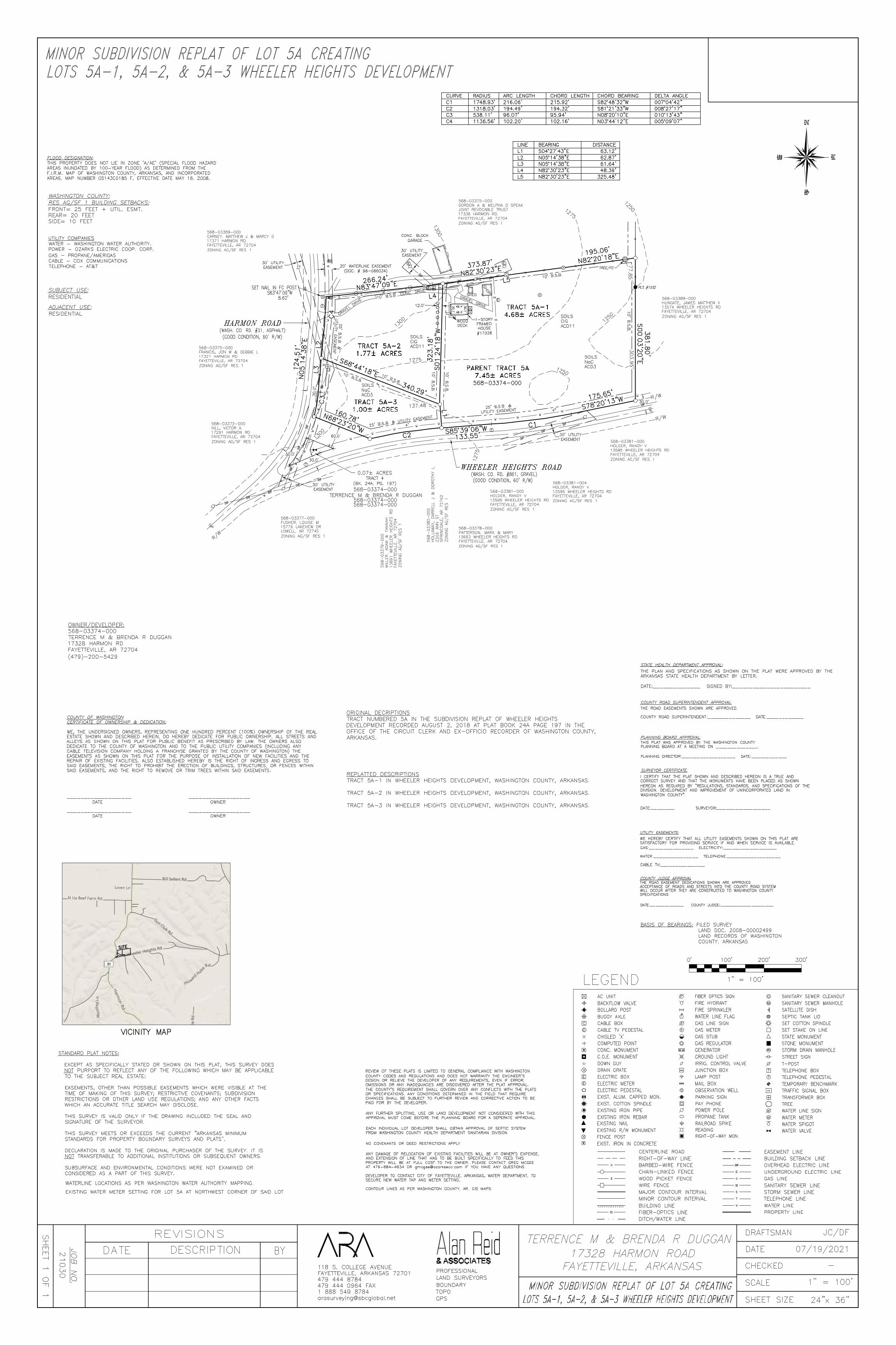
Date: July 27, 2021 PROJECT INFORMATION Applicant: Terrence M & Brenda Duggan Property Owner: Terrence M & Brenda Duggan Project Name: Replat Lot 5A Wheeler Heights Subdivision Location: 17328 Harmon Rd WC 31
Fayetteville, AR 72704 Project Number: 2021-247 Parcel Number: 568-03374-000 Project/Request Type: Minor Subdivision Replat
Description: The applicant is requesting minor subdivision replat approval to subdivide a lot within the Wheeler Heights Subdivision.
SITE INFORMATION Planning Area: None QC District: 1, Lance Johnson Acreage: 7.45 acres +/- School District: Springdale Current Zoning: Agriculture/Single-Family Residential 1 unit per acre Fire District: Wheeler Rural FIRM: 05143C0185F Wetlands: None Watershed: Little Wildcat-Clear Creek
UTILITIES Electricity: Ozark Electric Gas: Source Gas Cable: Cox Communications Phone: AT&T Water: Washington Water Authority
PLANNER INFORMATION Planner Assigned: Sita Nanthavong Email: [email protected] Phone: 479-444-1724
BACKGROUND/SYNOPSIS The applicants, Terrance & Brenda Duggan, are requesting minor subdivision replat approval to subdivide a lot within the Wheeler Heights Subdivision. The zoning is for Agricultural and Single Family Residential uses with a maximum density of one (1) residential unit per acre. The project parcel is not in a planning area. The proposal is located along the eastern side of Harmon Rd WC 31, just north of Wheeler Heights Rd WC 861. The project parcel is approximately 7.45 acres. This project cannot be processed administratively as it does not meet any of the criteria listed in Sec 11-79 (b).
There is an existing residence on the project parcel. The proposed Tract 5A-1 will retain the residence. The remaining proposed lots will be vacant.
A site inspection by a designated representative of ADH has stated that the proposed lots are suitable for septic systems and individual onsite septic systems. Please see the attached documents for more detailed information.
HARMON
PRIMROSE
SAVOY
LENAWHEELER HEIGHTS
HARM
ON
WHEELER HEIGHTS
HARM
ON
31
1127
86
861
861
31
Replat Lot 5A Wheeler Heights SubdivisionReplat Lot 5A Wheeler Heights Subdivision
Fayetteville
SpringdaleTontitown
Goshen
Farmington
Prairie Grove
Elkins
Johnson
Elm Springs
Lincoln
Greenland
West Fork
Winslow
Summers
Cane Hill
Evansville
Salem Springs
Cincinnati
MorrowDutch Mills
Litteral
DurhamSulphur City
Site data is drawn over Assessor GIS aerial imagery (2021),parcel, and street data. This map is not to be misconstruedas survey information. Parcel locations are based off thebest material at hand.
EACH INDIVIDUAL LOT DEVELOPER SHALL OBTAIN APPROVAL OF SEPTIC SYSTEM
AutoCAD SHX Text
FROM WASHINGTON COUNTY HEALTH DEPARTMENT SANITARIAN DIVISION
AutoCAD SHX Text
ANY FURTHER SPLITTING, USE OR LAND DEVELOPMENT NOT CONSIDERED WITH THIS
AutoCAD SHX Text
APPROVAL MUST COME BEFORE THE PLANNING BOARD FOR A SEPERATE APPROVAL.
AutoCAD SHX Text
REVIEW OF THESE PLATS IS LIMITED TO GENERAL COMPLIANCE WITH WASHINGTON COUNTY CODES AND REGULATIONS AND DOES NOT WARRANTY THE ENGINEER'S DESIGN OR RELIEVE THE DEVELOPER OF ANY REQUIREMENTS, EVEN IF ERROR, OMISSIONS OR ANY INADEQUACIES ARE DISCOVERED AFTER THE PLAT APPROVAL. THE COUNTY'S REQUIREMENT SHALL GOVERN OVER ANY CONFLICTS WITH THE PLATS OR SPECIFICATIONS. ANY CONDITIONS DETERMINED IN THE FIELD THAT REQUIRE CHANGES SHALL BE SUBJECT TO FURTHER REVIEW AND CORRECTIVE ACTION TO BE PAID FOR BY THE DEVELOPER.
AutoCAD SHX Text
UTILITY COMPANIES WATER - WASHINGTON WATER AUTHORITY. POWER - OZARKS ELECTRIC COOP. CORP. GAS - PROPANE/AMERIGAS CABLE - COX COMMUNICATIONS TELEPHONE - AT&T
AutoCAD SHX Text
NO COVENANTS OR DEED RESTRICTIONS APPLY
AutoCAD SHX Text
%%USURVEYOR CERTIFICATE:
AutoCAD SHX Text
%%UCOUNTY ROAD SUPERINTENDENT APPROVAL:
AutoCAD SHX Text
THE ROAD EASEMENTS SHOWN ARE APPROVED.
AutoCAD SHX Text
COUNTY ROAD SUPERINTENDENT:______________ DATE:____________
AutoCAD SHX Text
THE PLAN AND SPECIFICATIONS AS SHOWN ON THE PLAT WERE APPROVED BY THE
AutoCAD SHX Text
ARKANSAS STATE HEALTH DEPARTMENT BY LETTER.
AutoCAD SHX Text
DATE:______________ SIGNED BY:_______________________
AutoCAD SHX Text
%%USTATE HEALTH DEPARTMENT APPROVAL:
AutoCAD SHX Text
%%UUTILITY EASEMENTS:
AutoCAD SHX Text
WE HEREBY CERTIFY THAT ALL UTILITY EASEMENTS SHOWN ON THIS PLAT ARE
AutoCAD SHX Text
SATISFACTORY FOR PROVIDING SERVICE IF AND WHEN SERVICE IS AVAILABLE.
DATE:____________ COUNTY JUDGE:___________________
AutoCAD SHX Text
SPECIFICATIONS
AutoCAD SHX Text
WILL OCCUR AFTER THEY ARE CONSTRUCTED TO WASHINGTON COUNTY
AutoCAD SHX Text
ACCEPTANCE OF ROADS AND STREETS INTO THE COUNTY ROAD SYSTEM
AutoCAD SHX Text
THE ROAD EASEMENT DEDICATIONS SHOWN ARE APPROVED
AutoCAD SHX Text
%%UCOUNTY JUDGE APPROVAL
AutoCAD SHX Text
I CERTIFY THAT THE PLAT SHOWN AND DESCRIBED HEREON IS A TRUE AND CORRECT SURVEY AND THAT THE MONUMENTS HAVE BEEN PLACED AS SHOWN HEREON AS REQUIRED BY "REGULATIONS, STANDARDS, AND SPECIFICATIONS OF THE DIVISION, DEVELOPMENT AND IMPROVEMENT OF UNINCORPORATED LAND IN WASHINGTON COUNTY". DATE:________ SURVEYOR:__________________
AutoCAD SHX Text
ANY DAMAGE OF RELOCATION OF EXISTING FACILITIES WILL BE AT OWNER'S EXPENSE. AND EXTENSION OF LINE THAT HAS TO BE BUILT SPECIFICALLY TO FEED THIS PROPERTY WILL BE AT FULL COST TO THE OWNER. PLEASE CONTACT GREG MCGEE AT 479-684-4634 OR [email protected] IF YOU HAVE ANY QUESTIONS. DEVELOPER TO CONTACT CITY OF FAYETTEVILLE, ARKANSAS, WATER DEPARTMENT, TO SECURE NEW WATER TAP AND METER SETTING. CONTOUR LINES AS PER WASHINGTON COUNTY, AR. GIS MAPS
AutoCAD SHX Text
BASIS OF BEARINGS: FILED SURVEY FILED SURVEY LAND DOC. 2008-00002499 LAND RECORDS OF WASHINGTON COUNTY, ARKANSAS
AutoCAD SHX Text
MINOR SUBDIVISION REPLAT OF LOT 5A CREATING
AutoCAD SHX Text
LOTS 5A-1, 5A-2, & 5A-3 WHEELER HEIGHTS DEVELOPMENT
AutoCAD SHX Text
%%UCOUNTY OF WASHINGTON
AutoCAD SHX Text
%%uCERTIFICATE OF OWNERSHIP & DEDICATION:
AutoCAD SHX Text
WE, THE UNDERSIGNED OWNERS, REPRESENTING ONE HUNDRED PERCENT (100%) OWNERSHIP OF THE REAL
AutoCAD SHX Text
ESTATE SHOWN AND DESCRIBED HEREIN, DO HEREBY DEDICATE FOR PUBLIC OWNERSHIP, ALL STREETS AND
AutoCAD SHX Text
ALLEYS AS SHOWN ON THIS PLAT FOR PUBLIC BENEFIT AS PRESCRIBED BY LAW. THE OWNERS ALSO
AutoCAD SHX Text
DEDICATE TO THE COUNTY OF WASHINGTON AND TO THE PUBLIC UTILITY COMPANIES (INCLUDING ANY
AutoCAD SHX Text
CABLE TELEVISION COMPANY HOLDING A FRANCHISE GRANTED BY THE COUNTY OF WASHINGTON) THE
AutoCAD SHX Text
EASEMENTS AS SHOWN ON THIS PLAT FOR THE PURPOSE OF INSTALLATION OF NEW FACILITIES AND THE
AutoCAD SHX Text
REPAIR OF EXISTING FACILITIES. ALSO ESTABLISHED HEREBY IS THE RIGHT OF INGRESS AND EGRESS TO
AutoCAD SHX Text
SAID EASEMENTS, THE RIGHT TO PROHIBIT THE ERECTION OF BUILDINGS, STRUCTURES, OR FENCES WITHIN
AutoCAD SHX Text
SAID EASEMENTS, AND THE RIGHT TO REMOVE OR TRIM TREES WITHIN SAID EASEMENTS.
AutoCAD SHX Text
___________________ __________________
AutoCAD SHX Text
DATE OWNER
AutoCAD SHX Text
DATE OWNER
AutoCAD SHX Text
___________________ __________________
AutoCAD SHX Text
R/W
AutoCAD SHX Text
C
AutoCAD SHX Text
L
AutoCAD SHX Text
C
AutoCAD SHX Text
303.95'
AutoCAD SHX Text
CONC. BLOCK
AutoCAD SHX Text
GARAGE
AutoCAD SHX Text
HARMON ROAD
AutoCAD SHX Text
(WASH. CO. RD. #31, ASPHALT)
AutoCAD SHX Text
R/W
AutoCAD SHX Text
R/W
AutoCAD SHX Text
L
AutoCAD SHX Text
C
AutoCAD SHX Text
TREE/FC
AutoCAD SHX Text
568-03374-000
AutoCAD SHX Text
568-03389-000 HUNGATE, JAMES MATTHEW II 13574 WHEELER HEIGHTS RD FAYETTEVILLE, AR 72704 ZONING AG/SF RES 1
AutoCAD SHX Text
568-03381-000 HOLDER, RANDY V 13595 WHEELER HEIGHTS RD FAYETTEVILLE, AR 72704 ZONING AG/SF RES 1
AutoCAD SHX Text
568-03381-004 HOLDER, RANDY V 13595 WHEELER HEIGHTS RD FAYETTEVILLE, AR 72704 ZONING AG/SF RES 1
AutoCAD SHX Text
WHEELER HEIGHTS ROAD
AutoCAD SHX Text
568-03375-000 GORDON A & MELPHA D SPEAK JOINT REVOCABLE TRUST 17336 HARMON RD, FAYETTEVILLE, AR 72704 ZONING AG/SF RES 1
AutoCAD SHX Text
(WASH. CO. RD. #861, GRAVEL)
AutoCAD SHX Text
568-03381-005 HOLDER, RANDY V 13595 WHEELER HEIGHTS RD FAYETTEVILLE, AR 72704 ZONING AG/SF RES 1
AutoCAD SHX Text
568-03378-000 PATTERSON, MARK & MARY 13653 WHEELER HEIGHTS RD FAYETTEVILLE, AR 72704 ZONING AG/SF RES 1
AutoCAD SHX Text
568-03380-000 HOLLAWAY, DARRELL J & DOROTHY L 2206 ANN ST SPRINGDALE, AR 72762 ZONING AG/SF RES 1
AutoCAD SHX Text
568-03379-000 MILLER, ADAM & TANNAH 13691 WHEELER HEIGHTS RD FAYETTEVILLE, AR 72704 ZONING AG/SF RES 1
AutoCAD SHX Text
568-03377-000 FUSHER, LOUISE M 15776 LAKEVIEW DR LOWELL, AR 72745 ZONING AG/SF RES 1
AutoCAD SHX Text
568-03372-000 HILL, VICTOR A 17291 HARMON RD FAYETTEVILLE, AR 72704 ZONING AG/SF RES 1
AutoCAD SHX Text
568-03370-000 FRANCIS, JON W & DEBBIE L 17321 HARMON RD FAYETTEVILLE, AR 72704 ZONING AG/SF RES 1
AutoCAD SHX Text
568-03369-000 CARNEY, MATTHEW J & MARCY D 17371 HARMON RD, FAYETTEVILLE, AR 72704 ZONING AG/SF RES 1
AutoCAD SHX Text
PLS #1532
AutoCAD SHX Text
S83%%d47'09"W
AutoCAD SHX Text
8.62'
AutoCAD SHX Text
SET NAIL IN FC POST
AutoCAD SHX Text
%%uSUBJECT USE:
AutoCAD SHX Text
LOTS 5A-1, 5A-2, & 5A-3 WHEELER HEIGHTS DEVELOPMENT
AutoCAD SHX Text
RESIDENTIAL
AutoCAD SHX Text
%%uADJACENT USE:
AutoCAD SHX Text
RESIDENTIAL
AutoCAD SHX Text
(GOOD CONDITION, 60' R/W)
AutoCAD SHX Text
(GOOD CONDITION, 60' R/W)
AutoCAD SHX Text
0'
AutoCAD SHX Text
100'
AutoCAD SHX Text
200'
AutoCAD SHX Text
300'
AutoCAD SHX Text
1" = 100'
AutoCAD SHX Text
SITE
AutoCAD SHX Text
VICINITY MAP
AutoCAD SHX Text
4"
AutoCAD SHX Text
18"
AutoCAD SHX Text
WATERLINE LOCATIONS AS PER WASHINGTON WATER AUTHORITY MAPPING.
AutoCAD SHX Text
EXISTING WATER METER SETTING FOR LOT 5A AT NORTHWEST CORNER OF SAID LOT
AutoCAD SHX Text
ORIGINAL DECRIPTIONS TRACT NUMBERED 5A IN THE SUBDIVISION REPLAT OF WHEELER HEIGHTS DEVELOPMENT RECORDED AUGUST 2, 2018 AT PLAT BOOK 24A PAGE 197 IN THE OFFICE OF THE CIRCUIT CLERK AND EX-OFFICIO RECORDER OF WASHINGTON COUNTY, ARKANSAS.
AutoCAD SHX Text
REPLATTED DESCRIPTIONS TRACT 5A-1 IN WHEELER HEIGHTS DEVELOPMENT, WASHINGTON COUNTY, ARKANSAS. TRACT 5A-2 IN WHEELER HEIGHTS DEVELOPMENT, WASHINGTON COUNTY, ARKANSAS. TRACT 5A-3 IN WHEELER HEIGHTS DEVELOPMENT, WASHINGTON COUNTY, ARKANSAS.