washington ground-water quality - usgs
TRANSCRIPT

WASHINGTON
GROUND-WATER QUALITY
By S.S. Embrey
U.S. Geological Survey Open-File Report 87-0760

DEPARTMENT OF THE INTERIOR
DONALD PAUL MODEL, Secretary
U.S. GEOLOGICAL SURVEY
Dallas L. Peck, Director
For additional information:
Chief Hydrolocjist U.S. Geological Survey 407 National Center Reston,VA 22092
For sale by:
U.S. Geological SurveyBooks and Open-File Reports SectionFederal CenterBox 25425Denver, Colorado 80225
Use of trade names in this report is for descriptive purposes only and does not constitute endorsement by the U.S. Geological Survey

FOREWORD
This report contains summary information on ground-water quality in one of the 50
States, Puerto Rico, the Virgin Islands, or the Trust Territories of the Pacific Islands,
Saipan, Guam, and American Samoa. The material is extracted from the manuscript
of the 7986 National Water Summary, and with the exception of the illustrations,
which will be reproduced in multi-color in the 1986 National Water Summary, the
format and content of this report is identical to the State ground-water-quality
descriptions to be published in the 1986 National Water Summary. Release of this
information before formal publication in the 7986 National Water Summary
permits the earliest access by the public.

Contents
Ground-Water Quality .................................................. 1
Water-Quality in Principal Aquifers ...................................... 1
Background Water Quality ......................................... 1
Sodium-Adsorption Ratio ..................................... 1
Dissolved Solids .............................................. 1
Hardness .................................................... 1
Nitrate ...................................................... 2
Iron ......................................................... 2
Effects of Land Use on Water Quality ................................ 2
Urbanization ................................................. 2
Agricultural Practices ......................................... 2
Industrial Activities ........................................... 2
Waste Disposal and Hazardous Materials ....................... 3
Potential for Water-Quality Changes ................................ 3
Ground-Water-Quality Management ..................................... 3
Selected References .................................................... 4
Illustrations
Figure 1.-Selected geographic feature and 1985 population distribution in
Washington. ................................................. 5
Figure 2.--Principal aquifers and related water-quality data in Washington. .. 6
Figure 3.--Selected waste sites and ground-water quality information in
Washington. ................................................. 8
IV

WASHINGTONGround-Water Quality
During 1980, about 49 percent (2,014,000 people) of Washington's population used ground water for domestic needs (ad justed for population increase from 1975, after Dion and Lum, 1977). About 21 percent (873,000) of the State's population were rural residents, who depended on ground water from private wells. Nine counties, mostly in eastern Washington (fig. 1), depend solely on ground water to supply all domestic needs.
In general, ground water in Washington is of good quality and suitable for most uses (Barrett, 1986). Median concentrations of dissolved solids and nitrate (as nitrogen) in ground water from nine aquifers (fig. 2) did not exceed national drinking-water stan dards established by the U.S. Environmental Protection Agency (EPA) (1986a,b). In the Puget Sound area and in southwestern Washington, the suitability of ground water is affected locally by concentrations of naturally occurring iron and manganese (Ebbert and Payne, 1985; Turney, 1986a,), which may exceed national drinking-water standards.
Degradation of water quality due to urbanization, and agriculture, and industrial practices is occurring in densely populated areas (fig. IB) and in some rural areas of the State. In northwestern Washington, the population of San Juan County has nearly doubled since 1974, and that of Island County has increased by 50 percent. Increased ground-water withdrawals associated with coastal develop ment in these and other coastal counties may result in additional occurrences of localized saltwater intrusion. Agricultural effects on ground water include nitrate and pesticide contamination, which is occurring in parts of the Columbia Plateau and western Washington. Within the Hanford nuclear site in Franklin County, south-central Washington, industrial activities have resulted in con tamination of the ground water by nitrate in concentrations as much as 226 mg/L (milligrams per liter), and tritium more than 300 pCi/mL (picocuries per milliliter).
Nineteen sites in Washington are on the National Priorities List (NPL) established by the U.S. Environmental Protection Agency (1986c) for hazardous-waste clean-up under the Comprehensive En vironmental Response, Compensation, and Liability Act (CERCLA) of 1980 (fig. 3). Ground-water contamination has been detected at 16 of these CERCLA (Superfund) sites. In addition to the CERCLA sites, 25 hazardous-waste sites (fig. 3) are being monitored or evaluated under the Federal Resource Conservation and Recovery Act (RCRA) of 1976. Contamination of the ground water is known at nine of these RCRA sites. Also, the U.S. Department of Defense has identified 104 sites at 7 facilities as having potential for contamination.
WATER QUALITY IN PRINCIPAL AQUIFERS
Three principal aquifers are found in Washington (fig. 2/41); glacial-drift, terrace and valley-fill, and Columbia River basalt. Based on geographic boundaries within the State (fig 2/42) and geologic characteristics of the aquifers, the three principal aquifers have been subdivided into nine aquifers (Ebbert and Payne, 1985; Bortleson and Cox, 1987). The glacial-drift aquifer includes the Northeast and Puget Sound glacial-drift aquifers, and the Colum bia Plateau unconsolidated aquifer. The Columbia Plateau uncon- solidated aquifer includes the chemically similar glacial-drift and terrace and valley-fill aquifers (Turney, 1986b,c). The terrace and valley-fill aquifer includes the Mary's Corner, Vancouver, and Olympic Peninsula terrace and valley-fill aquifers (Molenaar and others, 1980). The Columbia River basalt aquifer includes the Saddle Mountains, Wanapum, and Grande Ronde basalt aquifers (U.S. Geological Survey, 1985, p. 433).
BACKGROUND WATER QUALITYA graphic summary of selected water-quality variables com
piled from the U.S. Geological Survey's National Water Data Storage and Retrieval System (WATSTORE) is presented in figure 1C. The summary is based on sodium-adsorption ratios (SAR), dissolved solids, hardness (as calcium carbonate), nitrate (as nitrogen), and iron analyses of water samples collected from 1960 to 1985 from the nine aquifers in Washington. Percentiles of these variables are compared to national standards that specify the max imum concentration or level of a contaminant in drinking-water supply as established by the U.S. Environmental Protection Agency (1986a,b). The primary maximum contaminant level standards are health related and are legally enforceable. The secondary maximum contaminant level standards apply to esthetic qualities and are recom mended guidelines. The primary drinking-water standards include a maximum concentration of 10 mg/L nitrate (as nitrogen), and the secondary drinking-water standards include maximum concentra tions of 500 mg/L dissolved solids and 300 /xg/L (micrograms per liter) iron.
Sodium-Adsorption Ratio
The sodium-adsorption ratio (SAR) is one method used to evaluate the suitability of water for irrigation use (U.S. Depart ment of Agriculture, 1954). The SAR is the tendency of a water to replace exchangeable, adsorbed calcium and magnesium ions with sodium ions. If the exchange positions in the soil become saturated with sodium, the soil will tend to become deflocculated, im permeable to water, and difficult to cultivate (Hem, 1985).
For waters of medium salinity (where specific conductance ranges from 250 to 750 microsiemens per centimeter at 25° Celsius), SAR values less than about 8 reflect a low sodium hazard; between about 8 and 14, a medium hazard; and more than 14, a high sodium hazard.
The median SAR for the nine aquifers was equal to or less than 1.0 (fig.2C), indicating that water from these aquifers most likely is suitable for irrigation. In water from the Northeast glacial- drift aquifer and the Columbia River basalts aquifer, SAR values as large as 23 and 26, respectively, were found. For the basalt aquifers in general, most of the larger SAR values (larger than 8) are located in discharge areas near major streams and in pumping centers within the central part of the Columbia Plateau (Bortleson and Cox. 1987).
Dissolved Solids
Median concentrations of dissolved solids for the nine aquifers were less than 320 mg/L (fig. 2C). The smallest median concentration of dissolved solids (68 mg/L) was in the Mary's Cor ner terrace and valley-fill aquifer; the largest median concentra tions (219 to 310 mg/L) were from water in the Columbia Plateau unconsolidated aquifer and in the Saddle Mountains, Wanapum, and Grande Ronde basalt aquifers. Aquifers in the Columbia Plateau area supply all or most of the domestic drinking water and some water for irrigation. The EPA secondary drinking water standard for dissolved solids of 500 mg/L is occasionally exceeded in water from individual wells in the Columbia Plateau area.
Hardness
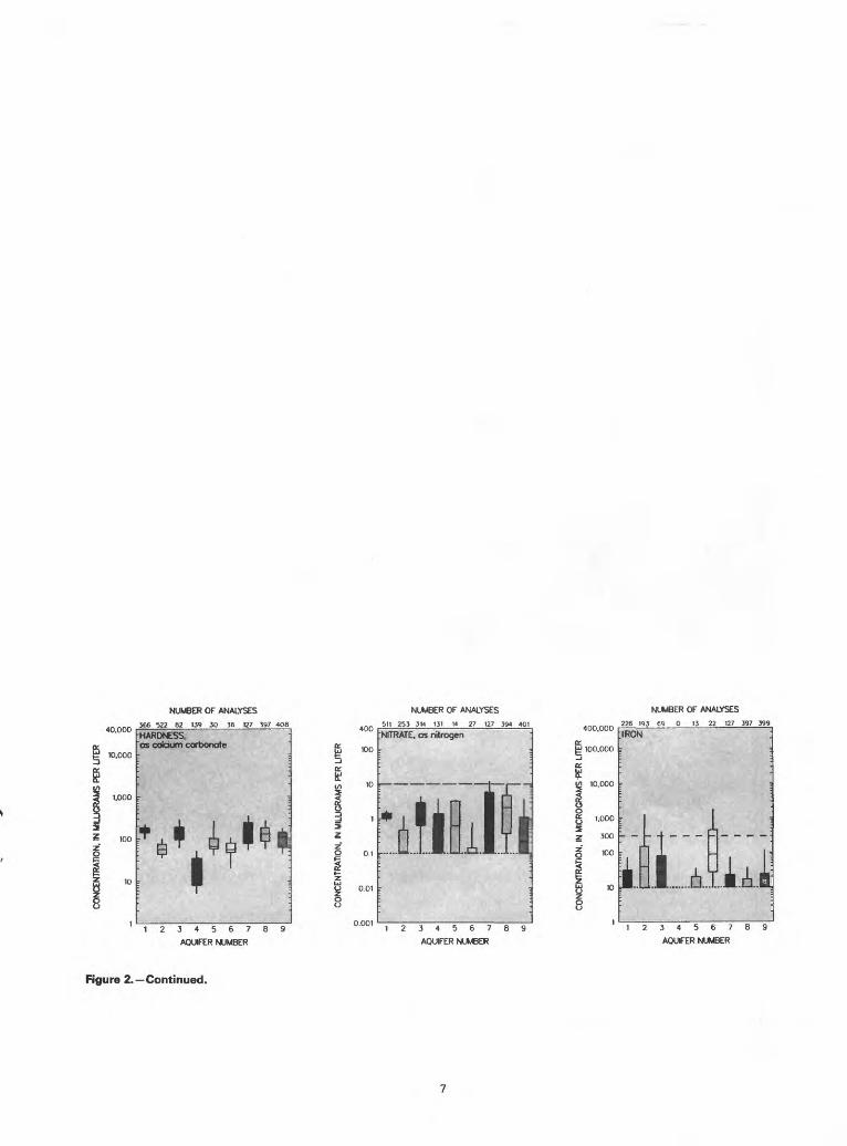
Hardness is caused primarily by calcium and magnesium in water; however, iron, manganese, and strontium can contribute to hardness. Median concentrations of hardness were less than 60 mg/L

(soft) in water from the Puget Sound glacial-drift aquifer, and the Mary's Corner and Olympic Peninsula terrace and valley-fill aquifers; less than 120 mg/L (moderately hard) in water from the Vancouver terrace and valley-fill aquifer and the Grande Ronde basalt aquifer; and less than 180 mg/L (hard) in water from the Northeast glacial-drift aquifer, the Columbia Plateau unconsolidated aquifer, and the Saddle Mountains and Wanapum basalt aquifers.
Nitrate
Median nitrate concentrations were less than 2.0 mg/L for all the unconsolidated aquifers; however, an occasional sample from the Columbia Plateau unconsolidated aquifer and the Mary's Cor ner terrace and valley-fill aquifer exceeded the EPA primary drinking-water standard of 10 mg/L. Water from the Wanapum basalt aquifer had the largest median nitrate concentration of 2.1 mg/L (fig. 2C). Maximum concentrations for the three basalt aquifers ranged from 15 mg/L in the Grande Ronde to 54 mg/L in the Saddle Mountains. Large concentrations of nitrate are prob ably a result of the agricultural activities (primarily fertilizer ap plication) on the Columbia Plateau (Turney, 1986b).
Iron
Concentrations of dissolved iron and manganese that exceed EPA secondary drinking-water standards are common throughout southwestern Washington and the Puget Sound area (Ebbert and Payne, 1985; Turney, 1986;) and probably reflect natural condi tions (Turney, 1986a). Median concentrations of dissolved iron were 40 /xg/L in the Puget Sound glacial-drift aquifer and 90 /xg/L in the Olympic Peninsula terrace and valley-fill aquifer (fig. 2C). A concentration of 31,000 /xg/L from a well in the Puget Sound glacial- drift aquifer was the maximum for all nine aquifers; the second largest concentration was 10,000 /xg/L from a well finished in the the Grande Ronde basalt aquifer.
EFFECTS OF LAND USE ON WATER QUALITYDegradation of ground-water quality has occurred from ur
banization, agriculture, industry, waste disposal, and from intru sion of saltwater along the coast associated with ground-water withdrawals.
Urbanization
Urbanization in Washington has been accompanied by the use of septic systems for sanitary-waste disposal. For instance, be tween 1970 and 1980, the population in central Pierce County in creased by about 22,000 people, with an additional transient military population of almost 30,000. This growth was accompanied by a deterioration of ground-water quality in the area (Littler and Aden, 1980; Littler and others, 1981). Littler and others (1981) deter mined that concentrations of nitrate, chloride, and bacteria increased over time, and they identified septic systems as one of the prin cipal causes of ground-water contamination.
The location of wells and areas with known ground-water contamination by one or more constituents including dissolved solids, nitrate, chloride, trace metals, and pesticides are shown in figure 3B. Nitrate concentrations that exceed the EPA primary drinking-water standard have been reported for several wells in populated areas near the confluence of the Columbia and Snake Rivers (John Aden, Washington State Department of Social and Health Services, written commun., 1986). Nitrate concentrations in water from many of these wells were 20 mg/L or more. Large concentrations of nitrate in these areas are suspected to result from the use of septic systems (Brown, 1979).
Recreational and residential development of the numerous islands in Puget Sound and along Pacific Ocean beaches has resulted in increased populations and corresponding greater demands on
ground-water supplies. The population of San Juan County, for in stance, increased from 4,500 in 1975 to 8,700 in 1983. Increases in the population of Island County and of coastal Pacific County also were large for the same time period. Dion and Sumioka (1984) described several areas of severe, but localized, saltwater intru sion within several coastal counties. Increased ground-water withdrawals or the installation of additional large-capacity wells in some areas of San Juan and Island Counties could result in addi tional occurrences of saltwater intrusion (Whiteman and others, 1983; Jones, 1985).
Agricultural Practices
Irrigation of increasingly large areas of the Columbia Plateau (about 1.5 million acres in 1982) using ground water and surface water from the Columbia, Yakima, and Snake Rivers, has occurred since the 1950's. Between 1954 and 1982, the area of irrigated land increased by 819,000 acres; of that amount, 311,000 acres (38 per cent) had been added since 1974 (U.S. Department of Commerce, Bureau of the Census, 1982). Irrigated acreage in Adams, Benton, and Franklin Counties increased by more than 43,000 acres each from 1954 to 1982, but the largest addition was 104,000 acres in Grant County, which by 1982 had a total of 397,000 irrigated acres. Ground water pumped from deep basalt aquifers in the central part of the Columbia Plateau has caused soil-dispersion problems due to large SAR values. Large nitrate concentrations in several domestic and public-supply wells in rural areas throughout the Columbia Plateau have been associated with long-term application of fer tilizers. Ground-water-quality problems in the Columbia River basalt and Columbia Plateau unconsolidated aquifers are complicated by excessively high water levels. These high water levels are caused by surface-water irrigation recharging the aquifers (Brown, 1979). Ground water in these areas may be subject to contamination where the aquifer is exposed at the land surface or by interception and inundation of septic systems.
Ethylene dibromide (EDB) has been used in Washington as a soil fumigant to protect strawberries, raspberries, and seed potatoes from nematodes. Several wells in berry-producing areas in What- com, Skagit, and Thurston Counties tap aquifers contaminated with this pesticide. Ten public water-supply and three private wells had EDB concentrations that exceeded levels considered safe (0.02 /xg/L) by the Washington State Department of Social and Health Services (1985) for long-term ingestion.
Industrial Activities
Drost and Seitz (1978) list several instances of documented contamination of ground water in the Northeast glacial-drift aquifer near Spokane. Large chloride concentrations near the Spokane In dustrial Park and an aluminum plant near Spokane were noted, and in 1975, a large concentration of phenol (15 mg/L) was reported in a well within the Spokane Industrial Park.
During monitoring efforts in the Spokane area between 1980 and 1982, the organic solvents 1,1,1-trichloroethane, trichloroethylene, tetrachloroethylene, and other organic chemicals, were found individually or together on separate occasions in five public-supply wells, one private well, and one industrial well (John Aden, Washington State Department of Social and Health Services, written commun., 1986). Concentrations as large as 62 /xg/L for 1,1,1-trichloroethane, 14 /xg/L for trichloroethylene, and 83 /xg/L for tetrachloroethylene were measured in water samples collected during 1981.
Operations at the Hanford nuclear site in Franklin County have discharged large volumes of process cooling water and other wastewaters onto the land surface. Areas of large tritium and nitrate concentrations at the site have been detected, and the migration of the constituents has been mapped as part of the Ground-Water

Surveillance Program (Prater and others, 1984). The report states that plumes of tritium and nitrate in the unconfined ground water are moving generally eastward from locations within the site and are entering the Columbia River through springs and subsurface flow. Tritium has been detected in concentrations exceeding 300 pCi/mL in wells within two plumes. Areas of large nitrate concen trations (greater than 10 mg/L) generally corresponded to areas where tritium concentrations exceed 30 pCi/mL. Two monitoring wells in the northern part of the site had average nitrate concentra tions of 226 and 86 mg/L during the 1983 study (Prater and others, 1984).
Waste Disposal and Hazardous Materials
During 1984, more than 91 percent of all hazardous wastes generated in Washington came from four counties; Spokane County ranked first in tons of waste generated, followed in order by Pierce, King, and Cowlitz Counties. The generated tonnage reported for Spokane County is large because the waste generated primarily is contaminated industrial wastewater, which is relatively heavy. About 66 percent of all hazardous wastes in the State were treated by chemical methods; 11 percent were disposed into surface impound ments for liquid wastes or in landfills; and the remaining 23 per cent were stored (Kruger, 1986).
Hazardous waste is stored or treated at 25 RCRA sites that are monitored for their impact on ground-water quality (fig. 3/1). At nine of these sites, the Washington Department of Ecology has detected onsite ground-water contamination. An additional 19 CERCLA sites in Washington associated with hazardous materials from industrial, waste-disposal, and agricultural activities, are in cluded on the ERA'S National Priorities List (NPL) for cleanup of contaminants under the "Superfund" program. Nine sites, including military installations, have been proposed for addition to the NPL. Ground-water contamination has been detected at 16 of the 19 CERCLA sites (fig. 3/1). The State maintains its own list of priority cleanup sites in addition to the ERA'S list, and in July 1986, an ad ditional 132 sites were proposed for the State's list. The nine pro posed CERCLA and the 132 State priority sites are shown in figure 3A as "other" sites. Ground-water-quality problems evident at these sites include pesticides and petrochemicals, especially near gasoline leaks and spills.
Six municipal landfills are among the 19 CERCLA sites (fig. 3/1). Five are located in Spokane County, and one is in King County. Contaminants found in landfills include lead, cyanide, and various synthetic organic solvents, such as acetone and methylene chloride. Disposal or storage sites that have received industrial wastes have had synthetic organic chemicals, especially solvents; trace metals, such as lead and chromium; and other chemicals, such as arsenic and cyanide detected in the ground water near them. Six of the nine sites proposed for the CERCLA program are located within military installations. Several types of contaminants, including trace metals, trichloroethylene, and synthetic organic chemicals related to deac tivated explosives, have been detected in ground water near five of these installations.
As of September 1985, 104 hazardous-waste sites at seven facilities in Washington had been identified by the U.S. Depart ment of Defense (DOD) as pan of their Installation Restoration Pro gram (IRP) as having potential for contamination (U.S. Department of Defense, 1986). The IRP, established in 1976, parallels the EPA Superfund program under CERCLA. The EPA presently ranks these sites under a hazard ranking system and may include them in the NPL. Of the 104 sites in the program, 2 sites contained contaminants but did not present a hazard to the environment. Six sites at three facilities were considered to present a hazard significant enough to warrant response action in accordance with CERCLA. Remedial action at one of these sites has been completed under the program.
The remaining five sites at two facilities (fig. 3/1) were scheduled for confirmation studies to determine if remedial action is required.
About 160 municipal and county sanitary landfill and waste- disposal sites exist in Washington (fig. 3C). Except for the land fills designated as CERCLA sites, little or no monitoring of ground water has been done to provide information on potential or existing contamination. As of May 1986, 55 of these landfills were closed or scheduled to be closed (Washington State Department of Ecology, written commun.. 1986).
POTENTIAL WATER-QUALITY CHANGESFuture degradation of ground-water quality may occur as a
result of population increase and land-use activities. Urban and in dustrial development between Spokane and Coeurd'Alene, Idaho, may subject the Northeast glacial-drift aquifer near Spokane to con taminants originating at or near the land surface, (Drost and Seitz, 1978; John Aden, Washington State Department of Social and Health Services, written commun., 1986). Present (1986) develop ment in San Juan, Island, Pacific, and Kitsap Counties and the ef fect on ground-water resources indicate the vulnerability of coastal aquifers to saltwater intrusion. Contamination of the shallow aquifer, such as has occurred in Kitsap County (Tracy and Dion, 1976) and near a hazardous-waste site in King County, probably will continue under the present methods of waste-management and disposal. The Washington Department of Ecology has compiled a list of 551 sites that are known to contain, or are suspected to contain hazardous wastes. The number of these sites has been increasing by about one to two per month (Barren, 1986).
In the Columbia Plateau, shallow aquifers are recharged with water containing nutrients, pesticides, and other agricultural chemicals applied to irrigated fields. The extent of pesticide con tamination is not yet known. However, because of the incidence of nitrate contamination, it is suspected that significant quantities of these organic chemicals have passed from the land surface into the shallow aquifers (Cohen and others, 1984).
GROUND-WATER-QUALITY MANAGEMENT
In Washington, protection of ground-water resources is the responsibility of the Washington State Department of Ecology ( WDOE) and the Washington State Department of Social and Health Services (DSHS). Based on Chapter 90.44 of the Revised Code of Washington, WDOE is responsible for administering all ground water in the State, including water rights, and regulating all well drilling and construction. Chapter 90.48 of the Revised Code designates the WDOE to administer the State's water-pollution-control statutes governing general water-pollution control, including mining and oil and gas activities. The Underground Injection Control provi sions of the Federal Safe Drinking Water Act (SDWA) and any ground-water provisions of the Federal Clean Water Act (CWA) are overseen by WDOE. The DSHS is responsible for regulating public- water systems, enforcing all laws for the protection of public health, and for administering the drinking-water protection aspects of the SDWA.
The Hazardous Waste Disposal Act (Chapter 70.105 Revised Code) assigns the WDOE to administer the Federal Resource Con servation and Recovery Act of 1976. This act emphasizes ground- water protection through adequate treatment and disposal of wastes and through issuance of permits, and compliance monitoring. It also provides for remedial actions, including CERCLA sites.
The Northeast glacial-drift aquifer near Spokane and the Puget Sound glacial-drift aquifer on Whidbey and Camano Islands are designated as sole-source aquifers to provide special protection of a drinking-water source. Under Section 208 of the CWA, a management plan was implemented for the Spokane aquifer.
Funding provided under Section 205 of the CWA has allowed studies to address the identification of sites of potential pollution.

the development of monitoring programs for the two sole-source aquifer areas, and the establishment of the relation between land- use activities and ground-water quality in a Pierce County basin. The WDOE and the State, under Section 205, are developing a nondegradation ground-water-quality management strategy. The goal of the strategy is "to maintain high quality for all waters of the State, allowing no reduction in water quality, except in over riding consideration of public interest. No reduction would be allowed to affect adversely the ability to use that water for its in tended beneficial use." It is the State's goal that implementation of the strategy will provide for the development of statewide stan dards for ground-water quality, including an aquifer-classification system, and will develop and support protection and management programs, including a comprehensive monitoring program to verify progress toward achieving water-quality goals.
State legislation in 1984 and 1985 permits local governments to deal effectively with ground-water quality and protection, pro vides means to finance aquifer protection through fees, and directs the WDOE to establish guidance and technical-assistance programs. The State House Bill 865 (1985 session) addition to Title 70 of the Revised Code created a hazardous-substance information and educa tion office at the WDOE.
Historical analytical data for ground-water quality are limited except for conventional inorganic chemicals and bacteria. The ex pense and difficulty of analyzing for organic chemicals remains a problem. The State is evaluating various approaches to monitoring for and assessing ground-water contamination. Even at sites with a significant contamination potential, there appears to be limited monitoring (Barrett, 1986), and many contamination incidents in Washington were first reported by citizens who suspected that their well water was contaminated.
Implementation of the State's nondegradation policy of the ground-water-quality management strategy presently is limited to determining when, where, and how much degradation is allowable on a case-by-case basis. The policy does not provide guidance to determine what is in the public interest, nor to determine allowable levels of contamination (Barrett, 1986). These limitations and the lack of adequate information on organic contamination of ground water tend to inhibit the development of an effective management strategy for the protection of ground water.
SELECTED REFERENCES
Barrett, Tony, 1986, State of Washington ground water quality manage ment strategy: Washington State Department of Ecology, Office of Water Quality, 66 p.
Bortleson, G.C., and Cox, S.E., 1987, Occurrence of dissolved sodium in ground waters in basalts underlying the Columbia Plateau, Washington: U.S. Geological Survey Water-Resources Investigations Report 85-4005, 24 p. [in press]
Brown, R.E., 1979, A review of water-well data from the unconfined aquifer in the eastern and southern parts of the Pasco basin: Rockwell Inter national, contract number DE-AC06-77RL01030, 63 p.
Cohen, S.Z., Creeger, S.M., Carsel, R.F., and Enfield C.G., 1984, Potential for pesticide contamination of ground water resulting from agricultural uses: Preprint for American Chemical Society Symposium Series, un numbered pages.
Dion, N.P., and Lum, W.E., II, 1977, Municipal, industrial, and irriga tion water use in Washington, 1975: U.S. Geological Survey Open- File Report 77-308, 34 p.
Dion, N.P., and Sumioka, S.S., 1984, Seawater intrusion into coastal aquifers in Washington, 1978: Washington State Department of Ecology Water-Supply Bulletin 56, 13 p.
Drost, B.W., and Seitz, H.R., 1978, Spokane Valley-Rathdrum Prairie aquifer, Washington and Idaho: U.S. Geological Survey Open-File Report 77-829, 79 p.
Ebbert, J.C., and Payne, K.L., 1985, The quality of water in the principal aquifers of southwestern Washington: U.S. Geological Survey Water- Resources Investigations Report 84-4093, 59 p.
Hearn, P.P., Steinkampf. W C., Bortleson, G.C., and Drost, B.W., 1985, Geochemical controls on dissolved sodium in basalt aquifers of the
I Columbia Plateau, Washington: U.S. Geological Survey Water- Resources Investigations Report 84-4304, 38 p.
Hem, J.D., 1985, Study and interpretation of the chemical characteristics of natural water: U.S. Geological Survey Water Supply Paper 2254, 264 p.
Jones, M.A., 1985, Occurrence of ground water and potential for seawater intrusion, Island County, Washington: U.S. Geological Survey Water- Resources Investigations Report 85-4046, 6 sheets.
Kruger, D.M., 1986, 1984 hazardous waste annual report summary: Washington State Department of Ecology, E&OE 86-3, 7 chapters.
Littler, J.D., and Aden, J.T., 1980, An evaluation of ground water quality for the Chambers Creek/Clover Creek drainage basin. Pierce County: Washington State Department of Social and Health Services, 39 p.
Littler, J.D., Aden, J.T., and Johnson, A.F., 1981, Survey of ground water and surface water quality for the Chambers Creek/Clover Creek drainage basin. Pierce County: Washington State Department of Social and Health Services, 103 p.
Molenaar, Dee, Grimstad, Peter, and Walters, K.L., 1980, Principal aquifers and well yields in Washington: U.S. Geological Survey Geohydrologic Monograph 5, scale 1:500,000, 1 sheet.
Prater, L.S., Rieger, J.T., Cline, C.S., Jensen, E.J., and others, 1984, Ground-water surveillance at the Hanford Site for CY 1983: Pacific Northwest Laboratory, contract number DE-AC06-76RLO 1830, 39 p.
Tracy, J.V. and Dion, N.P., 1976, Evaluation of ground-water contamination from cleaning explosive-projectile casings at the Bangor annex, Kit- sap County, Washington: U.S. Geological Survey Water-Resources Investigations 62-75, 44 p.
Turney, G.L., 1986a, Quality of ground water in the Puget Sound region, Washington: U.S. Geological Survey Water-Resources Investigations Report 84-4258, 170 p.
___ 1986b, Quality of ground water in the Columbia Basin, Washington, 1983: U.S. Geological Survey Water-Resources Investigations Report 85-4320, 172 p.
1986c, Quality of ground water in southeastern and south-centralWashington, 1982: U.S. Geological Survey Water-Resources Investiga tions Report 84-4262, 158 p.
U.S. Department of Agriculture, 1954, Diagnosis and improvement of saline and alkali soils: U. S. Department of Agriculture Handbook 60, 156 p.
U.S. Department of Commerce, Bureau of the Census, 1982, Census of Agriculture, vol. 1, pt. 47, Washington State County Data: 261 p.
U.S. Department of Defense, 1986, Status of the Department of Defense Installation Restoration Program Information paper: Washington, D.C., U.S. Department of Defense, Office of the Assistant Secretary of Defense (Acquisition and Logistics), Environmental Policy Direc torate, February,35 p.
U.S. Environmental Protection Agency, 1977, Quality criteria for water, 1976: Washington, D. C., 256 p.
___ 1986a, Maximum contaminant levels (subpart B of part 141, Na tional interim primary drinking-water regulations): U.S. Code of Federal Regulations, Title 40, Parts 100 to 149, revised as of July 1, 1986, p. 524-528.
___ 1986b, Secondary maximum contaminant levels (section 143.3 of part 143, National secondary drinking-water regulations): U.S. Code of Federal Regulations, Title 40, Parts 100 to 149, revised as of July 1, 1986, p. 587-590.
___ 1986c, Amendment to National Oil and Hazardous Substances Contingency Plan; national priorities list, final rule and proposed rule:Federal Register, v. 51,; no. Ill, June 10, 1986, p. 21053-21112.
U.S. Geological Survey, 1985, National water summary, 1984 Hydrologicevents, selected water-quality trends, and ground-water resources: U.S.Geological Survey Water-Supply Paper 2275, 467 p.
Washington State Department of Social and Health Services, 1985, Resultsand implications of the investigation of ethylene dibromide in groundwater in western Washington: Olympia, Washington, 32 p.
Whiteman, K.J., Molenaar, Dee, Bortleson, G.C., and Jacoby, J.M., 1983,Occurrence, quality, and use of ground water in Orcas, San Juan,Lopez, and Shaw Islands, San Juan County, Washington: U.S.Geological Survey Water-Resources Investigations Report 83-4019,sheet 7 of 12.

Prepared by S.S. Embrey
FOR ADDITIONAL INFORMATION: District Chief, U.S. Geological Survey, 1201 Pacific Avenue, Suite 600, Tacoma, WA 98402.
Figure 1. Selected geographic features and 1985 population distribution in Washington. A. Counties, selected cities, and major drainages. B, Population distribution, 1985; each dot on the map represents 1,000 people. (Source: B, Data from U.S. Bureau of the Census 1980 decennial census files, adjusted to the 1985 U.S. Bureau of the Census data for county populations.)

Olympic Mtns Puget Trough
Pacific
PRINCIPAL AQUIFER AND SUBDIVISIONSNumeral is aquifer number in figure 2C
___ GLACIAL-DRIFT AQUIFER {1-31 HI Northeast (II
I : -'.;'! Puget sound (21
HI Columbia Plateau unconsolidated (3) Includes both glacial drift and terrace and valley fill aquifers
TERRACE AND VALLEY-FILL AQUIFER (4-6»HI Mary's Corner (41
£jS^jj Vancouver (5)
I I Olympic Peninsula (61
__ COLUMBIA RIVER BASALT AQUIFER (7-9)HI Saddle Mountains (7)
Ff*l WanapumW)
HI Grande Ronde (9)
["* | Not a principal aquifer
A A' Trace of hydrogaologic section
Cascade Mtns Columbia Plateau
Columbia River
B Vertical scale greatly exaggerated
MAJOR REGIONS Geographic region boundary Aquifer region boundary
Grays> _ Elochoman
A2
WATER-QUALITY DATAParcantila - Percentage of analyses equal
to or less than indicated values 90th
75th
50th
25th
10lh
National drinklng-watar standards Maximum permissible contaminant
level (primary)- Maximum recommended contaminant
level (secondary) Reporting limit
........... Minimum reporting level withanalytical method used
NUMBER OF ANALYSES
494 62 138 24 36 127 397 406
SODIUM-ADSORPTION RATIO
300.000
e 100,000
1.000500
NUMBER OF ANALYSES
290 324 44 132 24 36 117 360
DISSOLVED SOLIDS
34567
AQUIFER NUMBER
34567
AQUIFER NUMBER
Figure 2. Principal aquifers and related water-quality data in Washington. A\. Principal aquifers; A2, Major geographic and aquifer-region boundaries; B. Generalized hydrogeologic section. C. Selected water-quality constituents and properties, as of 1960-85. (Sources: A\, U.S. Geological Survey, 1985, p. 433. A2. Molenaar and others, 1980. B. U.S. Geological Survey, 1985, p. 433; Bortleson and Cox, 1987. C, Analyses compiled from U.S. Geological Survey files; national drinking-water standards from U.S. Environmental Protection Agency, 1986a,b,)
3! CD 3
CO
NC
ENTR
ATIO
N,
IN M
ILU
CR
AMS
PER
LIT
ER
o
-CB- -O
n> -r
o-
CO
NC
ENTR
ATIO
N,
IN M
ILLI
GR
AMS
PER
LIT
ER
CO
NC
ENTR
ATIO
N,
IN M
ICR
OG
RAM
S PE
R L
ITER o

WASTE SITE - Darker symbol indicates site where contaminants were detected in ground water. Numeral indicates more than one site in same general location
CERCLA (Superfund)
RCRA 4 IRP
Other
GROUND-WATER QUALITYArea of water-quality concern Human-induced contamination
Well that yields contaminated wetar
LANDFILL SITECounty or municipal landfills, by county
Active or inactive__d1 0
EZJ 1-34-10 11-20
Figure 3. Selected waste sites and ground-water-quality information in Washington. A, Comprehensive Environmental Response, Compensation, and Liability Act (CERCLA) sites, as of 1986; Resource Conservation and Recovery Act (RCRA) sites, as of 1986; Department of Defense Installation Restoration Program (IRP) sites, as of 1985; and other selected waste sites, as of 1986. B, Areas of human-induced contamination and distribution of wells that yield con taminated water, as of 1975. C, County and municipal landfills, as of 1986. (Sources: A. U.S. Environmental Protection Agency, written commun., 1986; U.S. Department of Defense, 1986. B. Prater and others, 1984; Washington State Department of Ecology, written commun., 1986; Washington State Department of Social and Health Services, written commun., 1986; U.S. Environmental Protection Agency, written commun., 1986. C, Washington State Department of Ecology, written commun., 1986.)