wasson way trail feasibility studywassonway.org/files/wassonway_feasibilitystudy_webversion.pdf ·...
TRANSCRIPT
K Z F D e s i g n I n c . 7 0 0 B r o a d w a y S t r e e t C i n c i n n a t i , O H 4 5 2 0 2 m a i n 5 1 3 . 6 2 1 . 6 2 1 1 f a x 5 1 3 . 6 2 1 . 6 5 3 0 K Z F . C O M
W A S S O N W A Y T R A I L F E A S I B I L I T Y S T U D Y
J u n e 1 6 , 2 0 1 4
K Z F D E S I G N
W A S S O N W A Y T R A I L F E A S I B I L I T Y S T U D Y
page 2
Contents Executive Summary ..................................................................................................................................... 3
Existing Conditions .................................................................................................................................. 3
Design Guidelines................................................................................................................................... 3
Concept Alternatives ............................................................................................................................... 3
Recommended Alignment ......................................................................................................................... 4
Operations and Maintenance Budget ......................................................................................................... 4
Introduction ............................................................................................................................................... 6
Project Description .................................................................................................................................. 6
Purpose of Study ..................................................................................................................................... 6
Project Goals ......................................................................................................................................... 7
Relevant Plans ........................................................................................................................................ 7
Proposed Plans that affect the Study Area .................................................................................................... 8
Evaluation Items ...................................................................................................................................... 8
Existing Conditions ..................................................................................................................................... 8
Rail and Right-of-way ............................................................................................................................... 8
Bridges ................................................................................................................................................. 9
Topography ........................................................................................................................................... 9
Connecting Facilities ............................................................................................................................. 10
Surrounding Land Uses and Destinations .................................................................................................... 10
Design Guidelines and Standards ................................................................................................................ 12
Concept Alternatives ............................................................................................................................. 12
Segment Evaluation ............................................................................................................................... 13
Segment 1: Montgomery Road to Elsmere Avenue ....................................................................................... 15
Segment 2: Elsmere Avenue Across I-71 .................................................................................................... 16
Segment 3: I-71 to Kendall Avenue .......................................................................................................... 18
Segment 4: Kendall Avenue to Grovedale Place ......................................................................................... 20
Segment 5: Grovedale Place to Edwards Avenue ....................................................................................... 22
Segment 6: Edwards Avenue to Paxton Avenue .......................................................................................... 24
Segment 7: Paxton Avenue to Eastern Hills Lane ......................................................................................... 27
Segment 8: Eastern Hills Lane to Ault Park .................................................................................................. 30
Segment 9: Ault Park to Red Bank Road .................................................................................................... 35
Segment 10: Red Bank Road to Old Wooster Pike ...................................................................................... 37
Segment 11: Old Wooster Pike to Mariemont Gardens Access Drive. ............................................................ 41
Segment 12: Mariemont Gardens to Spring Hill Drive.................................................................................. 44
Segment 13: Spring Hill Drive to Newtown Road ....................................................................................... 45
W A S S O N W A Y T R A I L F E A S I B I L I T Y S T U D Y
page 3
Executive Summary
EXISTING CONDITIONS Linking Xavier University to the Little Miami Bike Trail, the Wasson Way Trail has the potential to connect eight neighborhoods and 100,000 residents with a network of more than 100 miles of trail facilities. There are nine existing bridges along the Wasson Way corridor. The trail crosses seven bridges and travels under two. It is feasible to retrofit all of the bridges for trail use. With a few notable exceptions, the terrain within the study area is well-suited for the development of a bike trail. The existing rail alignment itself maintains a consistent slope throughout the corridor. As such, the surrounding topography was altered, drastically in some areas, to accommodate the constant slope of the rail centerline. The Wasson Way Trail will serve local and regional destinations along the corridor. The neighborhoods have employment and recreation attractions, such as academic institutions, parks and shopping districts. Surrounding land uses directly impact potential usage on any bicycle or pedestrian facility.
DESIGN GUIDELINES The Wasson Way Trail will accommodate a wide range of users, including pedestrians, persons in wheelchairs and bicyclists of varied abilities including family cycling. Assumptions regarding trail design include:
§ Minimum pavement width: 8’, but typically 12’ where possible.
§ Typical shoulder width of trail: 3’ where possible
§ Minimum setback from railroad track centerline to obstructions or edge of trail tread: 8’. § Fence barrier: located between trail and existing rail centerline.
§ Typical setback from edge of tread to obstructions and buildings: 3’.
The trail itself will need further design and engineering by a professional in future stages of implementation stages of the various individual trail segments.
CONCEPT ALTERNATIVES After careful analysis of the existing conditions, plans within the corridor, current design standards and the goals of the Wasson Way Trail, the following conceptual design alternatives were developed for the purpose of analyzing construction feasibility and costs:
Alternate A – Baseline This alternate consists of a 12’ wide trail along entire existing rail alignment. The benefits to this alternate are the minimal costs of removing the rails and ties from the existing rail alignment and placing a 12’ wide asphalt path in its place. All of the bridges would be retrofitted and reused. This alternate is not discussed in detail in this Feasibility Study, however this baseline (minimum) cost will be included in the cost estimate for planning purposes.
Alternate B – Shared Rail/Trail Alignment This alternate consists of a 12’ wide trail offset from the existing rail alignment to the north. Where the right-of-way width will accommodate additional width for the planning of future rail lines, the trail will be offset additional width to make this accommodation. Where cost prohibitive, right-of-way constraints or other environmental/topography constraints exist, the trail will move on to the existing rail alignment and/or existing bridges.
Alternate C – New Trail Alignment This alternate will consist of a new, 12’ wide trail completely offset to the north of the existing rail. This would include new bridges and access facilities. It may also involve purchase of additional right-of-way.

W A S S O N W A Y T R A I L F E A S I B I L I T Y S T U D Y
page 4
RECOMMENDED ALIGNMENT For ease of discussion, the Wasson Way rail corridor was broken down into 13 segments, comprised of a variety of conditions, recommendations and proposed characters. New, shared and rail alignments were analyzed for feasibility, construction cost and right-of-way requirements. The recommended alignments balance long-term compatibility with costs, right-of-way constraints and future light rail service with the uncertain implementation timeline.
# Segment Length Description Major Constraints
1 Montgomery Rd to Elsmere 2,410’ Through old rail yard Crossing Montgomery Road
2 Elsmere Ave. across I-71 1,160’ Reuse existing bridges over I-71 Narrow right-of-way width and bridges
3 I-71 to Kendall Ave. 1,300’ North of existing rail, Withrow HS Minor drainage/privacy issues
4 Kendall across Grovedale 400’ Existing railroad bridge over Grovedale Place Drainage
5 Grovedale to Edwards 1,750’ Along Rookwood Commons, crossing Edwards/Madison
Narrow right-of-way (acq. For new Trail) Rookwood Wall Crosssing Madison/Edwards
6 Edwards to Paxton 2,730’ New trail, along Wasson Narrow right-of-way, on-street parking
7 Paxton to Eastern Hills 2,500’ New trail, near Wasson Retaining wall
8 Eastern Hills to Ault Park 5,000’ Deep cut on rail, narrow width Marburg Ave and Erie Ave bridges, major cut or retaining wall
9 Ault Park to Red Bank Rd 1,800’ Back of park/bridges Two large truss bridges
10 Red Bank to Old Wooster 2,250’ On rails, two ex. bridges Modifying two bridges
11 Wooster to Mariemont Ave 3.200’ Along rail yard access drive Railroad crossing at yard
12 Mariemont to Spring Hill 6,550’ Through South 80/Gardens under railroad bridge (Little Miami)
Requires acquisition railroad spur
13 Spring Hill to Newtown Rd 3,500’ Along Little Miami River, through Hamilton Co Park property Bridge over Walton Creek
Shared Rail/Trail Alignment 6.48 Miles Estimated Cost: $11,200,000
OPERATIONS AND MAINTENANCE BUDGET The average maintenance for an asphalt trail generally ranges between $3,500 and $6,000 per year, per mile. This largely depends upon the presence of restroom facilities (daily upkeep). Special circumstances such as flooding (cleanup and erosion) for trails along a river could push these costs significantly higher ($7,000). Quality construction methods and materials (surface drainage, adequate subbase and underdrains) and annual maintenance programs (crack sealing, routine pavement sealing and vegetation control) will defer long-term maintenance and extend the life of the trail significantly. Municipal park systems and other trail organizations recommend the creation of a strong volunteer program

W A S S O N W A Y T R A I L F E A S I B I L I T Y S T U D Y
page 5
to help with maintaining trails as a best practice. Given the urban setting of this trail, a minimum maintenance budget of $35,000 per year is recommended.
Operational costs for traffic signals and grade crossing devices are dependent upon design and coordination with local Departments of Transportation. Decisions to include lighting (type, location, hours of operation) parking and restroom/trailhead facilities will also play a major factor in these costs. Given current expectations, a minimum operational budget of $25,000 is recommended.

W A S S O N W A Y T R A I L F E A S I B I L I T Y S T U D Y
page 6
Introduction
PROJECT DESCRIPTION The Wasson Way Trail is a 6.5 mile proposed shared-use trail that runs along the Wasson Way Rail Corridor, from Xavier University to the Little Miami Bike Trail. The rail corridor is surrounded by residential, institutional, park and commercial property. Access to the trail through neighborhood connections will further connect surrounding communities and cities. The trail has the potential to connect eight neighborhoods and 100,000 Cincinnati residents with a network of more than 100 miles of trail facilities. The recreational, economic, transportation, aesthetic and social benefits of this trail facility and potential amenities have the potential to positively impact many residents and businesses in the region.
The Wasson Way corridor is currently owned by the Norfolk Southern Corporation. It has been proposed for future use as rail transit due to its connectivity to the proposed I-71 rail transit corridor. At the present time, there is no timing for implementation of rail transit facilities, however it has been recommended by local and regional planning authorities to be preserved for future rail use. Constructing the Wasson Way Trail will preserve the right-of-way for future use while improving the appearance of the property and putting it to an active use that benefits the surrounding communities.
PURPOSE OF STUDY This Feasibility Study for the Wasson Way Trail project is formatted to provide known information and factors to be considered in the design and location of the trail. The proposed project extends from the City of Cincinnati to the Village Newtown and will be developed as a multi-use trail. The purpose of this study is to determine potential costs of implementation of this project once the railway is acquired.
Complex issues surrounding ownership, future plans, land use, constructability, design standards, access, environmental impacts, safety and cost will be clarified within this study. The Wasson Way Board and Implementation Committee are ready to further develop their vision into a physical trail. To accomplish this, the Wasson Way Implementation Committee hired KZF Design, a Cincinnati Architecture, Engineering and Planning firm in 2013. KZF was tasked to review work previously completed and apply technical and professional engineering judgment to determine the feasibility and costs of the trail and to provide the documentation needed to pursue public capital sources and encourage private fundraising.

W A S S O N W A Y T R A I L F E A S I B I L I T Y S T U D Y
page 7
This Feasibility Study reviews existing conditions, current planning and engineering issues. The Study develops a conceptual design that meets the goals of the project in a way that is implementable and cost-effective. This Feasibility Study includes information the Wasson Way Board, City of Cincinnati and Great Parks of Hamilton County can use to pursue public and private funding sources. The second part of this Feasibility Study is a cost component. In order to pursue funding opportunities, the Wasson Way Board needs a detailed understanding of costs. This study includes an order of magnitude cost, based on historical costs and engineering/construction experience. This study does not include acquisition of the land from the Norfolk Southern, as this process has been initiated by the City of Cincinnati.
PROJECT GOALS The overall goals of the Wasson Way Trail project, as determined by the Implementation Committee, include:
1. Provide multi-modal transportation options, in an effort to reduce traffic and associated environmental effects.
2. Enliven the local community by increasing commercial opportunities and improving the appearance of surrounding properties, thus increasing property values.
3. Create additional green space within the City and provide easier access to existing green space for recreation, community engagement and transportation purposes.
4. Create a focal point for the City, attracting young professionals and their families.
5. Provide the ability to walk to local businesses, exercise and socialize in green public spaces.
RELEVANT PLANS Regional Rail Plan (2011) by OKI and the OKI 2040 Regional Transportation Plan (2012) These plans identify the Wasson Rail corridor for rail transit right-of-way preservation and/or acquisition.
Cincinnati Bicycle Transportation Plan (2010) This plan lays out a comprehensive strategy for making bicycling an integral part of daily life in Cincinnati. The plan identified the Wasson Way corridor as a future off-road facility or “Possible Rail with Trail Corridor” with an unknown timeframe for implementation. The plan recommended these facilities be constructed at a width of 10–15’ to ensure safety and comfortable use for bicyclists, runners, pedestrians and other trail users.
Plan Cincinnati (2012) This is the official document guiding future planning and development in the City of Cincinnati. The “Connect” section of the plan identified the Wasson Way corridor for further study:
“The Wasson Rail Corridor is proposed to be redeveloped for multi-modal transportation. To facilitate this, the City will be conducting a land use and transportation study on the Wasson Rail Corridor to find the best recommendation for its use, taking into consideration regional transportation plans such as the Eastern Corridor Plan and OKI Regional Rail Plan.”

W A S S O N W A Y T R A I L F E A S I B I L I T Y S T U D Y
page 8
Eastern Corridor Plan (1998) This is a multimodal plan with four categories of improvements including highway improvements, Transportation System Management, bus service expansion and right-of-way preservation for future rail transit. The Eastern Corridor Plan included preservation of the Wasson rail corridor from Xavier University to Fairfax for the purpose of connecting to future I-71 rail transit.
PROPOSED PLANS THAT AFFECT THE STUDY AREA Wasson Land Use Study: Preservation Solutions for the Wasson Rail Corridor The City of Cincinnati is actively developing a land use study for this corridor. The City has implemented an Interim Development Control (IDC) District on the Wasson Way corridor, which expires in June, 2014. This land use study was initiated to explore potential future uses for the Wasson Way corridor and recommend a solution for a more permanent preservation solution for the corridor.
EVALUATION ITEMS This study uses the Project Goals and other criteria for reviewing alternatives and options. Additional criteria considered included:
1. Consistency with existing plans and policies
2. Future rail uses and opportunities of the corridor
3. Existing physical features and topography (as observed)
4. Impacts on private property
5. User groups
6. Connections to other bikeways and the community
7. Safety
8. Cost (engineering and construction)
Existing Conditions
RAIL AND RIGHT-OF-WAY The existing Wasson Way rail corridor is owned by Norfolk Southern Corporation. At the time this Feasibility Study was completed, the City of Cincinnati was in the process of negotiating purchase of the land; however acquisition was still in progress. Ownership is instrumental to the feasibility of the trail. The rail line between Montgomery Road (Xavier University) and Red Bank Road (Ault Park) was active until September, 2010. Continuing east past Old Wooster Road, the rail lines and rail yard is still considered an active Norfolk Southern line.
Future use of this rail corridor is influenced by the implementation of rail transit, as this right-of-way is to be preserved for potential connection to I-71 light rail transit. Design and construction of trail facilities in this corridor should consider the option of coexisting with rail transit.

W A S S O N W A Y T R A I L F E A S I B I L I T Y S T U D Y
page 9
Using available CAGIS data, the railroad property area (right-of-way) was mapped along the corridor and determined to vary generally from up to 210’ wide and down to a minimum of 30’ wide. At various locations along the corridor, the existing property area may not be sufficient for both proposed trail/rail alignment(s). These conflicts have been noted. A detailed property survey may be required to verify ownership at various locations where property deeded to Norfolk Southern or property exchanges with private property owners may not have been captured in County records or where surrounding properties encroach on the existing right-of-way.
BRIDGES There are nine existing bridges along the Wasson Way corridor. The trail crosses seven bridges and travels under two. It is feasible to retrofit all of the bridges for trail use.
§ I-71 Southbound Ramp and I-71: These two bridges span over the I-71 ramp to Dana Avenue and I-71. The existing bridges are deck girders supporting a ballasted concrete tub deck. This type of bridge is easily converted to trail use. Drainage and railings will need to be addressed on both bridges. Given the location the bridge over I-71, a vandal protection fence will be required.
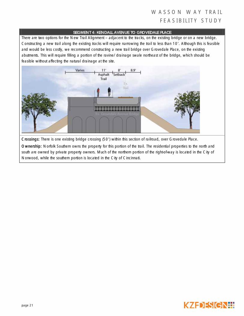
§ Grovedale Place: The bridge over Grovedale Place is a steel bridge with a concrete deck and four to 5’ of ballast. This bridge can easily be converted to trail use. A railing will need to be placed across the bridge for safety. The placement of the trail will not significantly affect the natural drainage at the site.
§ Marburg Avenue: This bridge is an overpass structure under Marburg Avenue. A replacement structure is currently under design by the City of Cincinnati.
§ Erie Avenue: This is an overpass structure under Erie Avenue.
§ Ault Park and Red Bank Road Trestles: These two bridges are comprised of two steel plate girders with timber cross ties placed directly on the girders. These bridges can easily be converted to trail use.
§ Columbia Parkway: This bridge is a steel through girder bridge with a ballasted metal deck over Columbia Parkway. This type of bridge is easily converted to trail use. Issues of drainage and a railing will need to be addressed. Given the location the bridge over Columbia Parkway, vandal protection fencing will also be needed.
§ Wooster Pike: This bridge is a through girder bridge with an open deck over Wooster Pike. The rail is supported on stringers that span between the floorbeams. Because of width restrictions, the face to face distance on this bridge will be limited to around 11’.
TOPOGRAPHY With a few notable exceptions, the terrain within the study area is well-suited for the development of a bike trail. Due to the nature of how railroad corridors are constructed, the existing rail alignment itself maintains a consistent slope

W A S S O N W A Y T R A I L F E A S I B I L I T Y S T U D Y
page 10
throughout the corridor. As such, the surrounding topography was altered, drastically in some areas, to accommodate the constant slope of the rail centerline. The highest point of elevation is at Xavier University at an elevation of 712‘ and continues a gradual drop down to the lowest point west of Mariemont at 494’.
In the western portion of the corridor, surrounding topography is fairly flat and construction of the rail line requires little modification to the surrounding grades. Moving east along the existing rail alignment, topography changes and major cuts and fills were required to accommodate the slope of the rail. Following the existing alignment east, the rail alignment rises above the surrounding existing grade between I-71 and Edwards Road. Further east, the rail drops down below the surrounding existing grades, sometimes to a depth of more than 20’ below the surrounding properties until it reaches Ault Park. Once into Ault Park, the topography varies greatly, requiring bridges to traverse the deep valleys. The corridor then drops down to the south of the Village of Mariemont where the topography levels out at the river elevations. Hillside Overlay District regulations occur where the hillsides are of significant public value. Development will need to be considered in this area (indicated in the map below) so any improvements will be compatible with regulations in regards to the natural environment and quality of the urban environment.
CONNECTING FACILITIES Linking Xavier University to the Little Miami Bike Trail, the Wasson Way Trail has the potential to connect eight neighborhoods and 100,000 residents with a network of more than 100 miles of trail facilities. At the western end of the corridor, the City of Cincinnati is exploring a potential rail-trail conversion that would connect to Victory Parkway, allowing access to the University of Cincinnati and possibly to downtown Cincinnati. Along the corridor, there are multiple connection points to existing and proposed on-road facilities through the Cincinnati Bicycle Transportation Plan. These locations include Madison Road, Edwards Road, Erie Avenue and Red Bank Road. The surrounding trail network will further connect surrounding communities, counties and cities.
Passing through Ault Park, there is also an opportunity to connect to the park’s trail facilities. Ultimately, the most significant connecting facility would be the Little Miami Scenic Trail, which travels 75 miles to the northeast to Springfield, in Clark County. The Little Miami Scenic Trail provides miles of well-shaded trail with great destinations along the route. Two state parks, John Bryan and Caesar Creek can be reached from the trail.
SURROUNDING LAND USES AND DESTINATIONS The Wasson Way Trail will serve local and regional destinations along the corridor. It will directly link the cities and villages of Cincinnati, Norwood, Fairfax, Mariemont and Newtown and indirectly link many other communities through
W A S S O N W A Y T R A I L F E A S I B I L I T Y S T U D Y
page 11
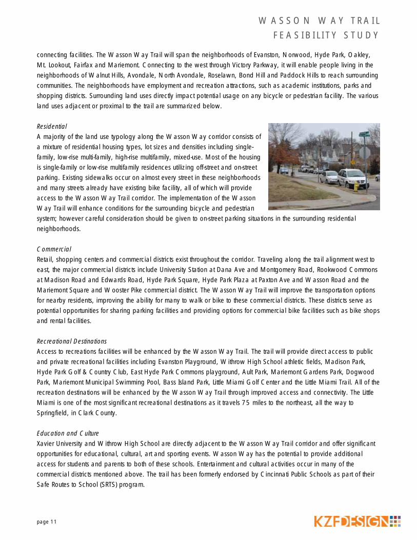
connecting facilities. The Wasson Way Trail will span the neighborhoods of Evanston, Norwood, Hyde Park, Oakley, Mt. Lookout, Fairfax and Mariemont. Connecting to the west through Victory Parkway, it will enable people living in the neighborhoods of Walnut Hills, Avondale, North Avondale, Roselawn, Bond Hill and Paddock Hills to reach surrounding communities. The neighborhoods have employment and recreation attractions, such as academic institutions, parks and shopping districts. Surrounding land uses directly impact potential usage on any bicycle or pedestrian facility. The various land uses adjacent or proximal to the trail are summarized below.
Residential A majority of the land use typology along the Wasson Way corridor consists of a mixture of residential housing types, lot sizes and densities including single-family, low-rise multi-family, high-rise multifamily, mixed-use. Most of the housing is single-family or low-rise multifamily residences utilizing off-street and on-street parking. Existing sidewalks occur on almost every street in these neighborhoods and many streets already have existing bike facility, all of which will provide access to the Wasson Way Trail corridor. The implementation of the Wasson Way Trail will enhance conditions for the surrounding bicycle and pedestrian system; however careful consideration should be given to on-street parking situations in the surrounding residential neighborhoods.
Commercial Retail, shopping centers and commercial districts exist throughout the corridor. Traveling along the trail alignment west to east, the major commercial districts include University Station at Dana Ave and Montgomery Road, Rookwood Commons at Madison Road and Edwards Road, Hyde Park Square, Hyde Park Plaza at Paxton Ave and Wasson Road and the Mariemont Square and Wooster Pike commercial district. The Wasson Way Trail will improve the transportation options for nearby residents, improving the ability for many to walk or bike to these commercial districts. These districts serve as potential opportunities for sharing parking facilities and providing options for commercial bike facilities such as bike shops and rental facilities.
Recreational Destinations Access to recreations facilities will be enhanced by the Wasson Way Trail. The trail will provide direct access to public and private recreational facilities including Evanston Playground, Withrow High School athletic fields, Madison Park, Hyde Park Golf & Country Club, East Hyde Park Commons playground, Ault Park, Mariemont Gardens Park, Dogwood Park, Mariemont Municipal Swimming Pool, Bass Island Park, Little Miami Golf Center and the Little Miami Trail. All of the recreation destinations will be enhanced by the Wasson Way Trail through improved access and connectivity. The Little Miami is one of the most significant recreational destinations as it travels 75 miles to the northeast, all the way to Springfield, in Clark County.
Education and Culture Xavier University and Withrow High School are directly adjacent to the Wasson Way Trail corridor and offer significant opportunities for educational, cultural, art and sporting events. Wasson Way has the potential to provide additional access for students and parents to both of these schools. Entertainment and cultural activities occur in many of the commercial districts mentioned above. The trail has been formerly endorsed by Cincinnati Public Schools as part of their Safe Routes to School (SRTS) program.
W A S S O N W A Y T R A I L F E A S I B I L I T Y S T U D Y
page 12
Design Guidelines and Standards
This section provides specific design guidelines for the Wasson Way Trail consistent with the guidelines currently observed in Ohio and throughout the US. The trail itself should accommodate bicycles and pedestrians in a safe and efficient manner. Planning, design and implementation standards in this document are derived from the following sources:
§ Rails-with-Trails: Lessons Learned, U.S. Department of Transportation, August 2002.
§ America’s Rails-with-Trails: A Resource for Planners, Agencies and Advocates on Trails along Active Railroad Corridors, Rails-to-Trails Conservancy, 2013.
§ American Association of State Highway and Transportation Officials (AASHTO), A Policy on Geometric Design of Highways and Streets, 2011.
§ AASHTO, Guide for the Development of Bicycle Facilities, 2012.
§ U.S. Department of Transportation (USDOT), Federal Highway Administration (FHA), Manual of Uniform Traffic Control Devices (MUTCD), 2009.
The Wasson Way Trail will accommodate a wide range of users, including pedestrians, persons in wheelchairs and bicyclists of varied abilities including family cycling. Assumptions regarding trail design include:
§ Minimum pavement width: 8’, but typically 12’ where possible.
§ Typical shoulder width of trail: 3’ where possible
§ Minimum setback from railroad track centerline to obstructions or edge of trail tread: 8’
§ Fence barrier: located between trail and existing rail centerline
§ Typical setback from edge of tread to obstructions and buildings: 3’
In the future, the trail will need further design and engineering by a professional before construction of any trail segment.
CONCEPT ALTERNATIVES After careful analysis of the existing conditions and plans within the corridor, current design standards and the goals of the Wasson Way Trail, the following conceptual design alternatives were developed for the purpose of analyzing construction feasibility and costs:
Alternate A – Baseline This alternate consists of a 12’ wide trail along entire existing rail alignment. The benefits to this alternate are the minimal costs of removing the rails and ties from the existing rail alignment and placing a 12’ wide asphalt path in its place. All of the bridges would be retrofitted and reused. This alternate is not discussed in detail in this Feasibility Study, however this baseline (minimum) cost is included in the cost estimate for planning purposes.
W A S S O N W A Y T R A I L F E A S I B I L I T Y S T U D Y
page 13
Alternate B – Shared Rail/Trail Alignment This alternate consists of a 12’ wide trail offset from the existing rail alignment to the north. Where the right-of-way width will accommodate additional width for the planning of future rail lines, the trail will be offset additional width to make this accommodation. Where cost prohibitive, right-of-way constraints or other environmental/topography constraints exist, the trail will move on to the existing rail alignment and/or existing bridges.
Alternate C – New Trail Alignment This alternate will consist of a new, 12’ wide trail completely offset to the north of the existing rail. This would include new bridges and access facilities. It may also involve purchase of additional right-of-way.
SEGMENT EVALUATION This study considers the feasibility of locating a shared-use path along the Norfolk Southern (Wasson) rail line. The trail should be located within the existing railroad property (right-of-way). The width of this right-of-way is shown on the aerial photography maps as part of this report. Also shown on the maps are the location of wetlands, physical constraints, buildings, parks, floodplains, roads and connecting facilities. The general area to be considered for location of the trail near the rail is illustrated by segment, showing both a Shared Rail/Trail Alignment and a New Trail Alignment. Trail Access Points are shown on the maps and discussed in the text suggest potential locations of bike facilities, parking, restrooms, trailhead or other development opportunities. The baseline alternate is shown on the map and referenced in each the segment section drawings to illustrate placement of the proposed trail.
Maps have been prepared for separate sections of the trail. Information is provided for each of these segments that should be considered in the engineering design and location of this path. The segments include the following:
1. Montgomery Road to Elsmere Avenue 2. Elsmere Avenue across I-71 3. I-71 to Kendall Avenue 4. Kendall Avenue to Grovedale Place 5. Grovedale Place to Edwards Road 6. Edwards Road to Paxton Avenue 7. Paxton Avenue to Eastern Hills Lane 8. Eastern Hills Lane to Ault Park 9. Ault Park to Red Bank Road 10. Red Bank Road to Old Wooster Pike (west of Mariemont) 11. Old Wooster Pike (west of Mariemont) to Mariemont 12. Mariemont to Wooster Pike 13. Wooster Pike to Newtown Road
EVANSTON PLAYGROUND
C I N C I N N A T IC I N C I N N A T I
N O R W O O DN O R W O O D
DANA AV
I-71 SB EXWY
I-71 NB EXWY
CLENEAY AV
FLO
RA
L AV
CLARION AV
HA
ZEL
AV
DUCK CREEK RD
TRIM
BLE
AV
MONTGOMER
Y RD
REG
ENT
AV
ELSM
ERE
AV
BEV
IS A
V
SPEN
CER
AV
LEXINGTON AV
EVA
NST
ON
AV
FOR
EST
AV
HUDSON AV
MA
DIS
ON
AV
BU
RWO
OD
AV
VIST
A AV
WA
BA
SH A
V
DOWNING DR
KEN
DA
LL A
V
I-71 SB EXWY TO DANA AV RAMP
WAYLAND AV
LILA
C A
V
MORTON AV
JEFF
ERSO
N A
V
RUTLAND AV
REA
LIST
IC A
V
DANA AV TO I-7
1 NB EXWY RAMP
HO
LLY
LN
BREWSTER AV
POTO
MA
C A
V
GRIGG AV
DANA AV TO I-71 SB EXWY RAMP
LAR
KSP
UR
AV
TAM
AR
AC
K A
V
CRANE AV
MID
DLE
BR
OO
K A
V
WES
TGAT
E AV
BA
RB
ERRY
AV
IVA
NH
OE
AV
MARLINGTON AV
CLAYLAND ST
I-71 NB EXWY TO EDMONDSON RD RAMP
DUCK CREEK RD TO DANA AV RAMP
FLO
RA
L AV
DUCK CREEK RD
BEV
IS A
V
LEXINGTON AV
HUDSON AV
WA
BA
SH A
V
LEXINGTON AV
HU
DSO
N A
V
GRIGG AV
1
2
3 4
I-71 OVERPASS
1-71 RAMP OVERPASS
CROSSING
DRAINAGE ISSUESNARROW RIGHT-OF-WAY
CONNECTIVITY TO EX. FACILITIES
WIDE ROW
WIDE RIGHT-OF-WAY
NARROW RIGHT-OF-WAY
1 inch equals 150 feet
LegendOpportunity
Contraint
Potential Trail Access Point
Ex. Wasson Way Rail Alignment
Ex. Bridges
Segment Location
Proposed Bike Facilities
Ex. Bike Facilities
Hillside Districts
Property Boundary
National Wetlands Inventory
FEMA Flood Zone

W A S S O N W A Y T R A I L F E A S I B I L I T Y S T U D Y
page 15
SEGMENT 1: MONTGOMERY ROAD TO ELSMERE AVENUE
Length: 2,410’
Description: Norfolk Southern rail yard with an overall width of 210’, which narrows down to 75’ wide towards the eastern end, then to 50’ wide at Elsmere Avenue.
Feasibility of Segment: The size of the property presents many options for placement of the trail, in addition to bike facilities, trailhead, parking or commercial development opportunities. It is likely that any new development will occur along Lexington Avenue, so placement of the trail should consider future development opportunities. Private property to the south presents an opportunity for businesses to access trail users. The fact that some portions of the existing right-of-way are in the City of Cincinnati and some in the City of Norwood could present some coordination issues between the different agencies. The cost of engineering and construction of this section should be minimal due to the level topography and the section of land being completely owned by the Norfolk Southern.
Recommended Location of Trail: There is considerable lee-way to locate the trail anywhere within the rail yard, between Lexington Avenue (north) and the existing rail lines (south side), observing the minimum 8’ from the existing rail lines. Future development of the property may be the most significant determining factor.
Crossings: There is one roadway crossing at Montgomery Road (4–5 lanes) within this section, at least 250’ north of the Dana Avenue intersection (signalized). This trail crossing will likely require significant unsignalized traffic control devices, such as a Rectangular Rapid Flash Beacon (RRFB) or HAWK (High-Intensity Activated CrossWalk). The railroad line does extend west beyond Montgomery Road, creating possibilities for trail extension in the future. With new development and the Xavier University main campus to the west, crossing traffic could be rather high.
W A S S O N W A Y T R A I L F E A S I B I L I T Y S T U D Y
page 16
SEGMENT 1: MONTGOMERY ROAD TO ELSMERE AVENUE Ownership: Norfolk Southern owns the property for this initial portion of the trail (existing rail yard). The properties to the south are owned by private property owners and the City of Norwood owns the property to the north (existing City right-of-way). Most of the railroad property is within the limits of the City of Norwood, however a portion of the railroad property and all private property to the south is in the City of Cincinnati.
Environmental: Soil contamination is a potential issue when building rail-to-trail projects. Rail yards are used for the transfer of contents to other modes of transportation and it is possible contamination of the soil has occurred in this area. An environmental investigation should be completed by an environmental expert to determine if areas of contamination exist and the extent.
SEGMENT 2: ELSMERE AVENUE ACROSS I-71
Length: 1,160’ Description: Short, narrow section of Norfolk Southern alignment as it crosses I-71 and its exit ramps (two bridges) at the Dana Avenue interchange with at-grade access at Elsmere Avenue.
Feasibility of Segment: The level topography and narrow corridor owned by the Norfolk Southern suggests a Shared Rail/Trail alignment proceed along the existing rail line.
For a New Trail Alignment, this section will require new bridge crossings alongside the existing railroad bridges over I-71, with retaining walls on the north side of the trail. With only a 30’ wide corridor, additional right-of-way will be required for a New Trail Alignment due to the limited width of the railroad property, specifically at The Growing Place Church property (3728 Floral Avenue) and approaches to new bridges across I-71.

W A S S O N W A Y T R A I L F E A S I B I L I T Y S T U D Y
page 17
SEGMENT 2: ELSMERE AVENUE ACROSS I-71
Recommended Location of Trail:
The Shared Rail/Trail Alignment should be located on the existing rail alignment and would reuse the existing railroad bridges over I-71 and the exit ramps. This would require the removal of the existing rails from the bridges, leveling the ballast, placing additional fill and paving. Vandal protection fence will be required on the bridges over I-71. Paving for the trail will span with width of the railroad bridges, requiring modification for stormwater drainage on the bridge. Water currently drains into the existing ballast, utilizing the existing bridge drainage system.
The New Trail Alignment option would require new bridges over I-71 and its ramps, north of the existing rail alignment. Retaining walls and fill will be required on the north side of the new trail to compensate for the existing grade and bridge skew, at a projected cost of more than $2 million.
Crossings: There is a closed street crossing at Elsmere Avenue that can provide at-grade pedestrian/bike access. Two bridge crossings (110‘ and 270‘) over I-71 are also within this section of railroad.
Ownership: Norfolk Southern owns the property for this portion of the trail. The properties to the north and south are owned by private property owners. New bridge work may require purchase of right-of-way for additional width at each end of the bridges. The Ohio Department of Transportation (ODOT) owns the existing bridges of I-71. Re-use of the existing bridges or construction of new bridges over I-71 will require coordination with ODOT. Property to the north of the existing rail line is in the City of Norwood and property to the south is within the limits of the City of Cincinnati.
It appears the new trail alignment will require right-of-way acquisition of at least portions of the two properties, 3728 Floral Avenue and 2445 Downing Drive.

W A S S O N W A Y T R A I L F E A S I B I L I T Y S T U D Y
page 18
SEGMENT 3: I-71 TO KENDALL AVENUE
Length: 1,300’ Description: East of I-71, the corridor is open and level with a 65’ (average) right-of-way width. Adjacent residential subdivisions back out onto the corridor.
Feasibility of Segment: Grades through this segment of trail are moderate and fairly wide. Drainage issues exist to the north of the rail alignment and a ditch to correct will add to construction costs. There may be issues with property ownership due to the limited width of the railroad property as it crosses I-71 (2445 Downing Drive property), as grading and a possible wall may impact property outside of the existing right-of-way. Tamarack Avenue and Withrow High School present opportunities for possible public access points or trailheads.
Recommended Location of Trail: The Shared/Rail Alignment should be located approximately 21’ north of the existing rail alignment, leaving room for a possible future second rail line.
Crossings: There are no roadway or bridge crossings within this section of railroad. Ownership: Norfolk Southern owns the property for this portion of the trail. The properties to the north and south are owned by private property owners.

MADISON PARK
C I N C I N N A T IC I N C I N N A T I
N O R W O O DN O R W O O D
MADISON RD
EDW
AR
DS
RD
WASSON RD
DR
AK
E AV
VICTORIA AV
SHAW
AV
BU
RC
H A
V
HYDE
PAR
K AV
PAXT
ON
AV
MINTO AV
MIC
HIG
AN
AV
ZUM
STEI
N A
V
STET
TIN
IUS
AV
DR
AK
EWO
OD
DR
KEN
DA
LL A
V
MO
ON
EY A
V
I-71 NB EXWY
I-71 SB EXWY
AN
DR
EW A
V
ARBOR AV
COX LN
ISA
BEL
LA A
V
GR
OVED
ALE PL
GRIFFITHS AV
MIL
LSB
RA
E AV
ARBOR PL
CADILLAC AV
HUDSON AV
EDROY CTDUCK CREEK RD
ROSELLA AVW
OO
DLAND AV
PORTSMOUTH AV
WILLARD AV
GR
OVE
DA
LE A
V
EDMONDSON RD
OU
TLO
OK
AV
MO
NTE
ITH
AV
MA
PLE PAR
K AV
VILLA LN
I-71 NB EXWY TO EDMONDSON RD RAMP
MARLINGTON AV
VIC
TOR
IA P
L
BESUDEN CT
SMITH RD TO I-71 SB EXWY RAMP
MID
DLE
BR
OO
K A
V
RAY
MA
R D
R
ST CHARLES PL
CO
LUM
BU
S AV
DOWNING DR
INVERNESS PL
HYDE PARK PL
SIGSBEE ST
GR
OVE
AV
PINEGROVE AV
ANDREW PL
MINTO DR
MIC
HIG
AN
AV
MO
NTE
ITH
AV
6
54
7
3
GROVEDALE PLACE OVERPASS
CROSSINGCROSSING
CROSSING
CROSSINGCROSSING
CROSSING
CROSSINGCROSSING
NARROW RIGHT-OF-WAY
NARROW RIGHT-OF-WAY
RETAINING WALL ISSUES
EX. FACILITY CONNECTIVITYEX. BRIDGE ACCOMMODATES TRAIL
1 inch equals 150 feet
LegendOpportunity
Contraint
Potential Trail Access Point
Ex. Wasson Way Rail Alignment
Ex. Bridges
Segment Location
Proposed Bike Facilities
Ex. Bike Facilities
Hillside Districts
Property Boundary
National Wetlands Inventory
FEMA Flood Zone

W A S S O N W A Y T R A I L F E A S I B I L I T Y S T U D Y
page 20
SEGMENT 4: KENDALL AVENUE TO GROVEDALE PLACE
Length: 400’ Description: Norfolk Southern 75’ wide (average) corridor, including an existing 27.9’ wide railroad bridge over Grovedale Place.
Feasibility of Segment: Reuse of the existing Grovedale Place Bridge along the existing rail line is feasible with the addition of bridge railing. The existing bridge is 27.9’ wide, constructed to accommodate two tracks.
A new trail alignment alongside the tracks would have to be narrowed (10’ or less) to fit on the existing bridge and still maintain a minimum 8’ setback from the existing rail. The bridge was built with additional width abutments – likely for a third rail – which could be used to cost-effectively support a new trail bridge. A grade drop northeast of the bridge will require some significant work – fill or retaining wall – to accommodate the alignment off this new bridge. Existing right-of-way along these steep slopes should provide sufficient right-of-way for potential grading or walls, if required.
Recommended Location of Trail: The Shared Rail/Trail Alignment should be located on the existing rail alignment and would reuse the existing bridge over Grovedale Place, avoiding the cost of a new bridge and fill. This would require the removal of the existing rails and constructing the 12’ wide asphalt trail on top of the ballast. A new bridge railing is required across the bridge for safety. The placement of the trail will not significantly affect the natural drainage at the site.
W A S S O N W A Y T R A I L F E A S I B I L I T Y S T U D Y
page 21
SEGMENT 4: KENDALL AVENUE TO GROVEDALE PLACE There are two options for the New Trail Alignment – adjacent to the tracks, on the existing bridge or on a new bridge. Constructing a new trail along the existing tracks will require narrowing the trail to less than 10’. Although this is feasible and would be less costly, we recommend constructing a new trail bridge over Grovedale Place, on the existing abutments. This will require filling a portion of the ravine/drainage swale northeast of the bridge, which should be feasible without affecting the natural drainage at the site.
Crossings: There is one existing bridge crossing (50’) within this section of railroad, over Grovedale Place.
Ownership: Norfolk Southern owns the property for this portion of the trail. The residential properties to the north and south are owned by private property owners. Much of the northern portion of the right-of-way is located in the City of Norwood, while the southern portion is located in the City of Cincinnati.

W A S S O N W A Y T R A I L F E A S I B I L I T Y S T U D Y
page 22
SEGMENT 5: GROVEDALE PLACE TO EDWARDS AVENUE
Length: 1,750’ Description: Norfolk Southern 30’ wide corridor, along the south side of the existing Rookwood Commons shopping center, then crossing Madison Road and Edwards Avenue within the commercial area. The Rookwood Commons parking lot is approximately 15’ below the existing grade of the rail alignment and the residences to the south.
Feasibility of Segment: The cost of engineering and construction varies depending on the proposed trail alignment. The corridor sites atop a 15–20’ high private wall, constructed as part of the shopping center development. A Shared/Rail Alignment can be built within the corridor by removing the rails, without affecting the wall.
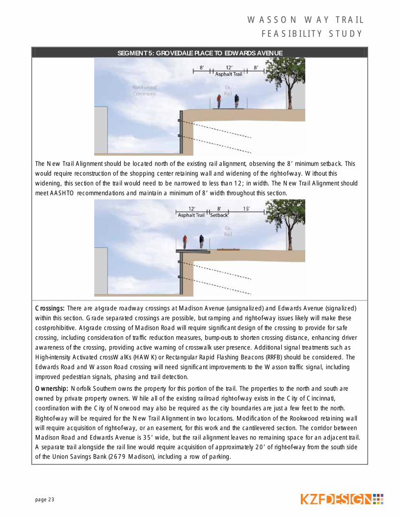
A full-width trail alongside the rail line (with 8’ minimum setback) will require substantial work on the wall. The existing wall is a privately owned, timber lagging wall that is not in good condition. The wooden lagging is splitting in need of repair. We recommend facing the wall with concrete to supplant the lagging and allow construction of a cantilever section to give the added room for a full 12’ width trail. Without replacement of the wall and widening of the right-of-way, this section of the trail may need to be narrowed to less than 12’ in width.
The section between Edwards and Madison Avenues (including the approach west of Madison), the existing corridor narrows to approximately 35’. The Shared/Rail Alignment can be built within the corridor by removing the rails. The New Trail Alignment north of existing rails would require significant R/W to construct, including the Union Savings Bank.
Recommended Location of Trail: The Shared Rail/Trail Alignment should be located on the existing rail alignment, avoiding the need to acquire R/W and costly modifications to the private wall.
W A S S O N W A Y T R A I L F E A S I B I L I T Y S T U D Y
page 23
SEGMENT 5: GROVEDALE PLACE TO EDWARDS AVENUE
The New Trail Alignment should be located north of the existing rail alignment, observing the 8’ minimum setback. This would require reconstruction of the shopping center retaining wall and widening of the right-of-way. Without this widening, this section of the trail would need to be narrowed to less than 12; in width. The New Trail Alignment should meet AASHTO recommendations and maintain a minimum of 8’ width throughout this section.
Crossings: There are at-grade roadway crossings at Madison Avenue (unsignalized) and Edwards Avenue (signalized) within this section. Grade separated crossings are possible, but ramping and right-of-way issues likely will make these cost-prohibitive. At-grade crossing of Madison Road will require significant design of the crossing to provide for safe crossing, including consideration of traffic reduction measures, bump-outs to shorten crossing distance, enhancing driver awareness of the crossing, providing active warning of crosswalk user presence. Additional signal treatments such as High-intensity Activated crossWalKs (HAWK) or Rectangular Rapid Flashing Beacons (RRFB) should be considered. The Edwards Road and Wasson Road crossing will need significant improvements to the Wasson traffic signal, including improved pedestrian signals, phasing and trail detection.
Ownership: Norfolk Southern owns the property for this portion of the trail. The properties to the north and south are owned by private property owners. While all of the existing railroad right-of-way exists in the City of Cincinnati, coordination with the City of Norwood may also be required as the city boundaries are just a few feet to the north. Right-of-way will be required for the New Trail Alignment in two locations. Modification of the Rookwood retaining wall will require acquisition of right-of-way, or an easement, for this work and the cantilevered section. The corridor between Madison Road and Edwards Avenue is 35’ wide, but the rail alignment leaves no remaining space for an adjacent trail. A separate trail alongside the rail line would require acquisition of approximately 20’ of right-of-way from the south side of the Union Savings Bank (2679 Madison), including a row of parking.

W A S S O N W A Y T R A I L F E A S I B I L I T Y S T U D Y
page 24
SEGMENT 6: EDWARDS AVENUE TO PAXTON AVENUE
Length: Length: 2,730’ Description: Norfolk Southern 30’ wide alignment south of Wasson Road.
Feasibility of Segment: The cost of engineering and construction for a rail alignment should be reasonable due to the level topography and the section of land being completely owned by Norfolk Southern. For a New Trail Alignment, this section will require a low retaining wall parallel to the existing rail alignment which will require additional construction costs. Both alignments, shared or new trail alignment, will require use of the City of Cincinnati’s right-of-way to accommodate the trail facilities.
Recommended Location of Trail: The alignment on the existing rail line would be simple and cost-effective to construct.
The New Trail Alignment is located north of the rail alignment, observing the 8’ minimum setback.
This would require placement of a new retaining wall parallel to the existing rail centerline to accommodate changes in grades. This section of the trail may need to be narrowed to less than 12’ in width to fit within the existing right-of-way. It is recommended that detailed study of this section consider possible modifications to Wasson Road, including an evaluation of on-street parking, separate pedestrian walkways and stormwater treatment. The Shared Rail/Trail Alignment is recommended alongside the rail lines, on the New Trail Alignment.

W A S S O N W A Y T R A I L F E A S I B I L I T Y S T U D Y
page 25
SEGMENT 6: EDWARDS AVENUE TO PAXTON AVENUE
Crossings: There are five roadway crossings at Michigan Avenue, Shaw Avenue, Hyde Park Avenue, Monteith Avenue and Paxton Avenue within this section of railroad, all adjacent to Wasson Way. All of these road crossings are unsignalized, with the exception of Paxton Avenue. Unsignalized crossings are anticipated to be treated as standard crosswalks, requiring trail users to stop before crossing. Sight distance is good at all crossings. The crossing of Paxton Avenue will be within the pedestrian phase of the signal. Ownership: Norfolk Southern owns the property for this portion of the trail. The property to the north is City of Cincinnati right-of-way and property to the south is owned by private property owners. The railroad property is relatively narrow in this section – varies from 30’ to approximately 27’ wide nearing Paxton. The Wasson Road street right-of-way, owned by the City of Cincinnati, is 50’ wide. Any New Trail Alignment alongside the existing rail line will require working within both the railroad right-of-way as well as the City of Cincinnati’s Wasson Road street right-of-way.

OAKLEY PLAYGROUND
HYDE PARK COUNTRY CLUB
C I N C I N N A T IC I N C I N N A T I
VICTORIA AV
PAXT
ON
AV
WASSON RD
MA
RB
UR
G A
V
PORTSMOUTH AV
ERIE AV
DR
AK
E AV
MINTO AV
HYDE
PAR
K AV
BAYARD DR
TAR
PIS
AV
ZIEGLE AV
ISA
BEL
LA A
V
RAY
MA
R B
LVD
CADILLAC AV
DR
AK
EWO
OD
DR
AN
DR
EW A
V
RAY
MA
R D
R
MT
VER
NO
N A
V
OAK LN
ST CHARLES PL
OU
TLO
OK
AV
FER
DIN
AN
D P
L
MO
NTE
ITH
AV
SHA
DY
LN
OAK VIEW PL
VIC
TOR
IA L
N
DE FOREST DR
STERLING WY
HER
SCH
EL A
V
GLENHURST PL
MAPLECREST PL
AMELIAMONT AV
ASTON CT
GREENHOU SE LN
CO
LUM
BU
S AV
EAST
ERN
HIL
L LN
SAWGRASS LN
ROSELLA AV
PINEGROVE AV
PAPE AV
KIL
BO
UR
NE
AV
HER
SCH
EL V
IEW
PL
HYDE PARK PL
MINTO DR
ANDREW PL
CLOI STER CT
MAR
BURG
SQU
ARE
LN
MO
NTE
ITH
AV
MO
NTE
ITH
AV
WASSON RD
7
8
6
CROSSING
CROSSINGCROSSINGCROSSING
NARROW RIGHT-OF-WAYPOTENTIAL RETAINING WALL
WIDE RIGHT-OF-WAY
PROP. BRIDGE ACCOMMODATES TRAIL
1 inch equals 150 feet
LegendOpportunity
Contraint
Potential Trail Access Point
Ex. Wasson Way Rail Alignment
Ex. Bridges
Segment Location
Proposed Bike Facilities
Ex. Bike Facilities
Hillside Districts
Property Boundary
National Wetlands Inventory
FEMA Flood Zone
W A S S O N W A Y T R A I L F E A S I B I L I T Y S T U D Y
page 27
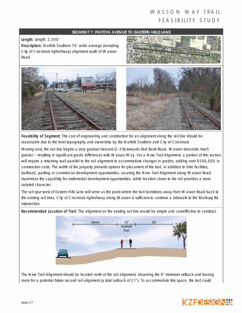
SEGMENT 7: PAXTON AVENUE TO EASTERN HILLS LANE
Length: Length: 2,500’ Description: Norfolk Southern 70’ wide average (including City of Cincinnati right-of-way) alignment south of Wasson Road.
Feasibility of Segment: The cost of engineering and construction for an alignment along the rail line should be reasonable due to the level topography and ownership by the Norfolk Southern and City of Cincinnati.
Moving east, the rail line begins a very gradual descent (2–3%) towards Red Bank Road. Wasson descends much quicker – resulting in significant grade differences with Wasson Way. For a New Trail Alignment, a portion of this section will require a retaining wall parallel to the rail alignment to accommodate changes in grades, adding over $500,000 in construction costs. The width of the property presents options for placement of the trail, in addition to bike facilities, trailhead, parking or commercial development opportunities. Locating the New Trail Alignment along Wasson Road maximizes the capability for multi-modal development opportunities, while location closer to the rail provides a more isolated character.
The rail spur west of Eastern Hills Lane will serve as the point where the trail transitions away from Wasson Road back to the existing rail lines. City of Cincinnati right-of-way along Wasson is sufficient to continue a sidewalk to the Marburg Rd. intersection.
Recommended Location of Trail: The alignment on the existing rail line would be simple and cost-effective to construct.
The New Trail Alignment should be located north of the rail alignment, observing the 8’ minimum setback and leaving room for a potential future second rail alignment (a total setback of 21’). To accommodate this space, the trail could
W A S S O N W A Y T R A I L F E A S I B I L I T Y S T U D Y
page 28
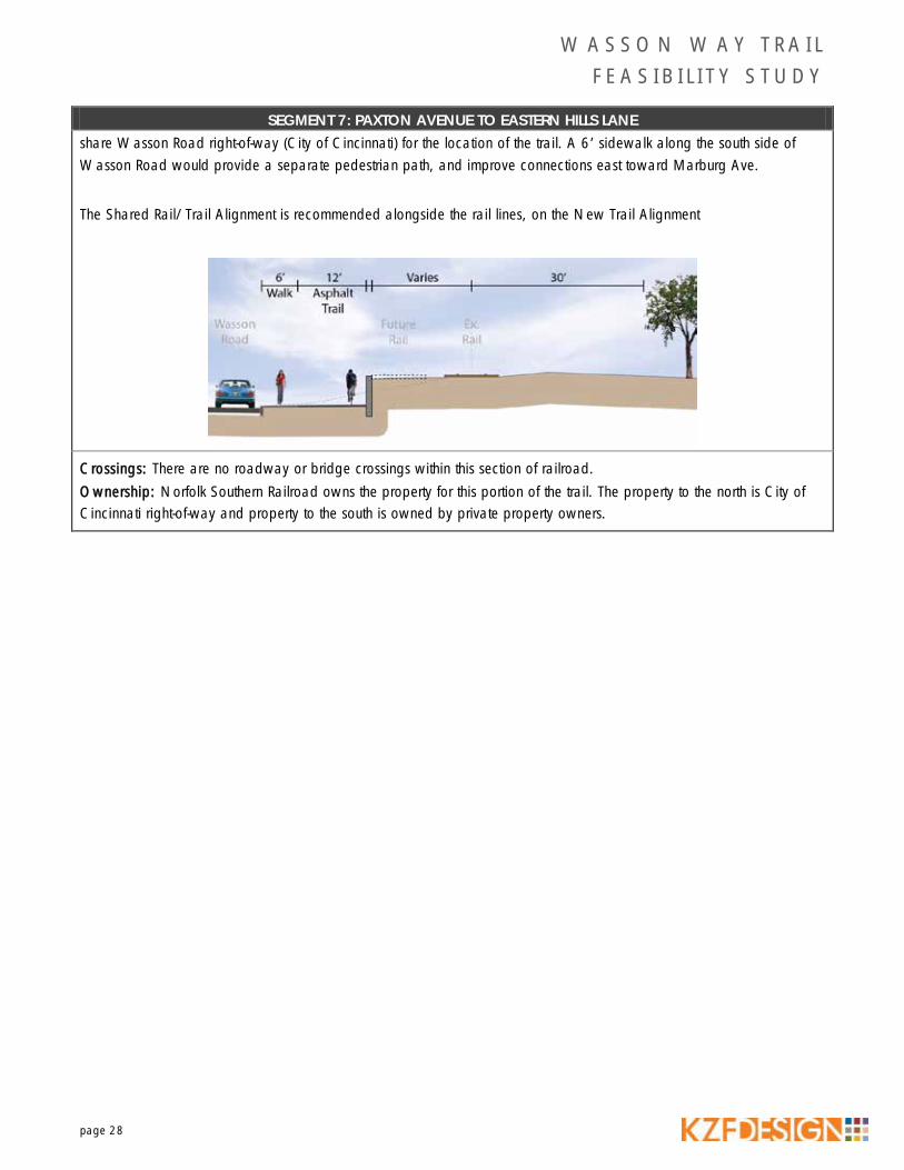
SEGMENT 7: PAXTON AVENUE TO EASTERN HILLS LANE share Wasson Road right-of-way (City of Cincinnati) for the location of the trail. A 6’ sidewalk along the south side of Wasson Road would provide a separate pedestrian path, and improve connections east toward Marburg Ave.
The Shared Rail/Trail Alignment is recommended alongside the rail lines, on the New Trail Alignment
Crossings: There are no roadway or bridge crossings within this section of railroad. Ownership: Norfolk Southern Railroad owns the property for this portion of the trail. The property to the north is City of Cincinnati right-of-way and property to the south is owned by private property owners.

AULT PARK
HYDE PARK COUNTRY CLUB
C I N C I N N A T IC I N C I N N A T I
ERIE
AV
PAPE AV
SAYBROOK AV
MA
RB
UR
G A
V
AULT PARK AV
ASHWORTH DR
TAR
PIS
AV
OBSERVATORY AV
WASSON RD
AVERY LN
PARKLINE AV
BREN
TWO
OD A
V
AYLESBORO AV
BELL
ECRE
ST A
V
WIL
SHIR
E AV
HAMPTO
N LN
FOREST HILL DR
PEMBROKE AV
HER
SCH
EL V
IEW
PL
AM
BER
SON
AV
VICTORIA AV
OAK VIEW PL
PIN
EHU
RST
AV
VIC
TOR
IA L
N
DE FOREST DR
HER
SCH
EL A
V
TRA
SKW
OO
D C
IR
GLENHURST PL
ASTON CT
FOREST HILL LN
GREENHOU SE LN
HAMPTON CT
CU
STER
AV
EAST
ERN
HIL
L LN
SAWGRASS LN
WEL
LSTO
N P
L
WIL
LOW
LEA
CT
BAYARD DR
BEE
CH
AM
LN
ST JOHNS PL
PORTSMOUTH AV
AU
LT V
IEW
AV
OB
SER
VATO
RY P
L
OB
SER
VATO
RY H
ILL
AV
MAR
BURG
SQU
ARE
LN
OB
SER
VATO
RY H
ILL
AV
8
9
7ERIE AVENUE OVERPASS
MARBURG AVENUE OVERPASS
POTENTIAL RETAINING WALL
EX. BRIDGE OVERPASS NARROW
ACCESS TO AULT PARK
PROP. BRIDGE ACCOMMODATES TRAIL
1 inch equals 150 feet
LegendOpportunity
Contraint
Potential Trail Access Point
Ex. Wasson Way Rail Alignment
Ex. Bridges
Segment Location
Proposed Bike Facilities
Ex. Bike Facilities
Hillside Districts
Property Boundary
National Wetlands Inventory
FEMA Flood Zone

W A S S O N W A Y T R A I L F E A S I B I L I T Y S T U D Y
page 30
SEGMENT 8: EASTERN HILLS LANE TO AULT PARK
Length: 5,000’ Description: Norfolk Southern 100’ wide alignment south of Wasson Road. As the rail drops toward Red Bank Road, the corridor develops a significant cut – up to 18’ deep.
Feasibility of Segment: The rail line is in a deep cut, with steep (roughly 3:1) slopes and room at the bottom for ditches and rail bed. While feasible, the cost of engineering and construction for a New Trail Alignment will be significant due to steep topography, bridges, walls and grading. For a New Trail Alignment, this section significant earthwork or a long retaining wall will be required to move back the north slope. Re-grading the slopes is costly and would significantly impact the Hyde Park Country Club. A retaining wall would be sizeable and costly (more than $5,000,000).
There is plenty of Cincinnati right-of-way to continue the 6’ sidewalk from the previous segment along Wasson Road to the Marburg Road intersection. The Erie Avenue bridge will need to be replaced to accommodate the New Trail Alignment. The Marburg Avenue bridge is currently under study by the City of Cincinnati and should be designed with adequate width to accommodate the existing rail alignment and 12’ wide trail. Walls and significant grading will be required throughout much of this section, and may require cooperation with surrounding property owners and possible purchase of additional right-of-way. This section also has significant drainage issues since most of the trail is at an elevation below the surrounding properties. Grading that will need to be addressed to maintain the integrity of the constructed trail. Saybrook Avenue presents an opportunity for a possible public access point or trailhead.
Recommended Location of Trail: The Shared Rail/Trail Alignment should be located on the existing rail alignment.
The grade changes past Eastern Hills Lane and the rail line begins to drop below the surrounding elevation. The trail would continue on the rail alignment. Swales should be constructed on each side of the trail to fix drainage issues.

W A S S O N W A Y T R A I L F E A S I B I L I T Y S T U D Y
page 31
SEGMENT 8: EASTERN HILLS LANE TO AULT PARK As the trail passes under the Marburg Avenue Bridge, the Shared Rail/Trail Alignment should continue on the existing rail line.
As the trail passes under the Erie Avenue Bridge, the Shared Rail/Trail Alignment should continue on the existing rail line. Drainage on both sides of the trail will need to be incorporated under this bridge.
A New Trail Alignment should be located north of the existing rail alignment, observing the 8’ minimum setback. To accommodate this space, the trail would utilize City of Cincinnati right-of-way along Wasson Road for the location of the trail.

W A S S O N W A Y T R A I L F E A S I B I L I T Y S T U D Y
page 32
SEGMENT 8: EASTERN HILLS LANE TO AULT PARK As the grades change, the existing rail line begins to drop below the surrounding elevation. The trail would continue to run parallel to the existing rail alignment, observing the 8’ setback. Walls will be required. To accommodate existing drainage issues, swales should be constructed on each side of the trail.
To keep construction costs down, a lower-cost option would include significant grading far beyond the existing right-of-way.
The New Trail Alignment should continue to be located north of the existing rail alignment as it passes under the City of Cincinnati’s proposed Marburg Avenue Bridge.
W A S S O N W A Y T R A I L F E A S I B I L I T Y S T U D Y
page 33
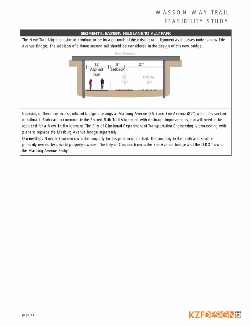
SEGMENT 8: EASTERN HILLS LANE TO AULT PARK The New Trail Alignment should continue to be located north of the existing rail alignment as it passes under a new Erie Avenue Bridge. The addition of a future second rail should be considered in the design of this new bridge.
Crossings: There are two significant bridge crossings at Marburg Avenue (55’) and Erie Avenue (80’) within this section of railroad. Both can accommodate the Shared Rail/Trail Alignment, with drainage improvements, but will need to be replaced for a New Trail Alignment. The City of Cincinnati Department of Transportation Engineering is proceeding with plans to replace the Marburg Avenue bridge separately. Ownership: Norfolk Southern owns the property for this portion of the trail. The property to the north and south is primarily owned by private property owners. The City of Cincinnati owns the Erie Avenue bridge and the ODOT owns the Marburg Avenue Bridge.
AULT PARK
F A I R F A XF A I R F A X
C I N C I N N A T IC I N C I N N A T I M A R I E M O N TM A R I E M O N T
RED
BA
NK
RD
COLUMBIA EB PKWY
COLUMBIA WB PKWY
WOOSTER PIKE
OLD
RED
BA
NK
RD
WOOS
TER
RD
NIGHTINGALE DR
MEADOW LARK LN
RED BANK TO COLUMBIA EB PKWY RAMP
AULT PARK AV
JONLEN DR
AYLESBORO AV
TRADE ST
VIRG
INIA
AV
COLUMBIA WB PKWY TO RED BANK RAMP
MARIEMONT AV
GRACE AV
TRA
SKW
OO
D C
IR
CHICKADEE CT
WO
OD
LAN
D R
D
FORESTO
AK
CT
NIG
HTIN
GA
LE C
T
SAYBROOK AV
COLUMBIA PKWY TO RED BANK RAMP
RED BANK TO COLUMBIA PKWY RAMP
ORIOLE CT
WIL
LOW
LEA
CT
COLUMBIA EB PKWY TO RED BANK RAMP
WOOSTER PIKE
10
9
11
8
RED BANK TRESTLE BRIDGE
AULT PARK TRESTLE BRIDGE
COLUMBIA PARKWAY OVERPASS
WOOSTER OVERPASS
ACCESS TO AULT PARK
ACCESS TO RED BANK ROAD
1 inch equals 150 feet
LegendOpportunity
Contraint
Potential Trail Access Point
Ex. Wasson Way Rail Alignment
Ex. Bridges
Segment Location
Proposed Bike Facilities
Ex. Bike Facilities
Hillside Districts
Property Boundary
National Wetlands Inventory
FEMA Flood Zone

W A S S O N W A Y T R A I L F E A S I B I L I T Y S T U D Y
page 35
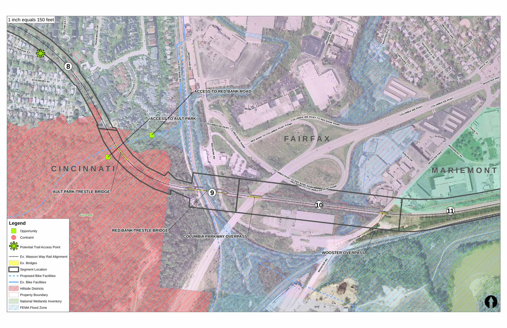
SEGMENT 9: AULT PARK TO RED BANK ROAD
Length: 1,800’ Description: Norfolk Southern 80’ wide alignment through Ault Park including bridge over Red Bank Road.
Feasibility of Segment: The cost of engineering and construction for a Shared Rail/Trail Alignment along the rail line is more expensive in this section, with modifications to the bridges. For a New Trail Alignment, construction costs would be considerable as this section will require a new 230’ bridge through Ault Park and retaining walls. Construction will be complicated by steep slopes (20% or greater) and the remote location in the middle of Ault Park.
Recommended Location of Trail: The Shared Rail/Trail Alignment should be located on the existing rail alignment.
The Shared Rail/Trail Alignment should reuse the existing trestle bridges in Ault Park, and over Red Bank Road. The rail and ties will need to be removed. The conceptual design would be to place transverse beams on top of the girders at a 6’ spacing to support the trail. Transverse beams (14’ long) would support railing posts at the ends of the beams, with a metal decking placed on top of the beams, which would then be filled with asphalt to provide the riding surface.

W A S S O N W A Y T R A I L F E A S I B I L I T Y S T U D Y
page 36
SEGMENT 9: AULT PARK TO RED BANK ROAD
The New Trail Alignment should be located north of the existing rail alignment, observing the 8’ minimum setback.
The New Trail Alignment should be located north of the existing rail alignment, observing the 8’ minimum setback.
Crossings: There is one bridge crossing in Ault Park (230’) within this section of railroad. Ownership: Norfolk Southern owns the property for this portion of the trail.
W A S S O N W A Y T R A I L F E A S I B I L I T Y S T U D Y
page 37
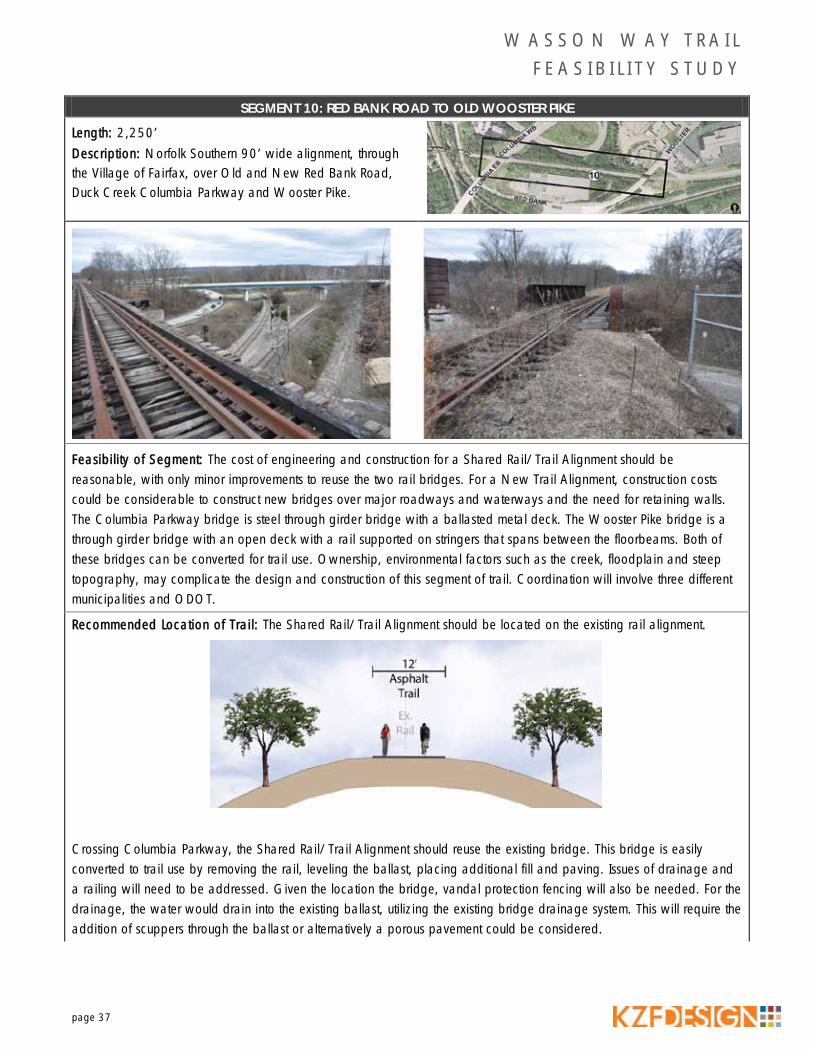
SEGMENT 10: RED BANK ROAD TO OLD WOOSTER PIKE
Length: 2,250’ Description: Norfolk Southern 90’ wide alignment, through the Village of Fairfax, over Old and New Red Bank Road, Duck Creek Columbia Parkway and Wooster Pike.
Feasibility of Segment: The cost of engineering and construction for a Shared Rail/Trail Alignment should be reasonable, with only minor improvements to reuse the two rail bridges. For a New Trail Alignment, construction costs could be considerable to construct new bridges over major roadways and waterways and the need for retaining walls. The Columbia Parkway bridge is steel through girder bridge with a ballasted metal deck. The Wooster Pike bridge is a through girder bridge with an open deck with a rail supported on stringers that spans between the floorbeams. Both of these bridges can be converted for trail use. Ownership, environmental factors such as the creek, floodplain and steep topography, may complicate the design and construction of this segment of trail. Coordination will involve three different municipalities and ODOT.
Recommended Location of Trail: The Shared Rail/Trail Alignment should be located on the existing rail alignment.
Crossing Columbia Parkway, the Shared Rail/Trail Alignment should reuse the existing bridge. This bridge is easily converted to trail use by removing the rail, leveling the ballast, placing additional fill and paving. Issues of drainage and a railing will need to be addressed. Given the location the bridge, vandal protection fencing will also be needed. For the drainage, the water would drain into the existing ballast, utilizing the existing bridge drainage system. This will require the addition of scuppers through the ballast or alternatively a porous pavement could be considered.

W A S S O N W A Y T R A I L F E A S I B I L I T Y S T U D Y
page 38
SEGMENT 10: RED BANK ROAD TO OLD WOOSTER PIKE
Crossing Wooster Road, transverse beams would be placed on top of the existing stringers at a 6’ maximum spacing to support the trail. The transverse beams would be 11’ long and support railing post off the ends of the beams. A metal decking would be placed on top of the beams which would then be filled with asphalt to provide the riding surface. Because of width restrictions the face to face distance on this bridge will be limited to around 11’.
The New Trail Alignment should be located north of the existing rail alignment, observing the 8’ minimum setback. Retaining walls and fill will be required on the north side of the new trail to compensate for the existing grade.
The New Trail Alignment option would require new bridges over Old/New Red Bank Road, Columbia Parkway and Wooster Pike located to the north of the existing rail alignment. Retaining walls and fill will be required on the north side of the new trail to compensate for the existing grade.

W A S S O N W A Y T R A I L F E A S I B I L I T Y S T U D Y
page 39
SEGMENT 10: RED BANK ROAD TO OLD WOOSTER PIKE
Crossings: There are three bridge crossings, Old/New Red Bank Road Park (430’), Columbia Parkway (130‘) and Wooster Pike (75‘) within this section of railroad. Ownership: Norfolk Southern owns the property for this portion of the trail. Portions of this segment exist in the City of Cincinnati, Village of Fairfax and Village of Mariemont. Ownership of the bridge should be confirmed.
MARIEMONT GARDENS PARK
DOGWOOD PARK
F A I R F A XF A I R F A X
M A R I E M O N TM A R I E M O N T
C I N C I N N A T IC I N C I N N A T I
WOOSTER PIKE
MARIEMONT AV
COLUMBIA EB PKWY
COLUMBIA WB PKWY
SPR
ING
ST
MARY ST
WOOS
TER
RD
MIAMI BLUFF DR
ELEANOR ST
JONLEN DR
TRADE ST
GRACE AV
MEADOW LARK LN
NIGHTINGALE DR
DRAGON W Y
RED
BAN
K T
O C
OLU
MBI
A EB
PKW
Y RA
MP
CHICKADEE CT
RED BANK RD
COLUMBIA WB PKWY TO RED BANK RAMP
PLEASANT ST
SOUTHERN AVVIRG
INIA
AV
AR
RO
W P
OIN
T W
Y
COLUMBIA PKWY T O RED B
ANK RAMP
HARVARD ST
WOOSTER PIKE
MARIEMONT AV
11
12
10
WOOSTER OVERPASS
ACCESS ROAD TUNNELL
ACTIVE RAILROAD CROSSING
1 inch equals 150 feet
LegendOpportunity
Contraint
Potential Trail Access Point
Ex. Wasson Way Rail Alignment
Ex. Bridges
Segment Location
Proposed Bike Facilities
Ex. Bike Facilities
Hillside Districts
Property Boundary
National Wetlands Inventory
FEMA Flood Zone
W A S S O N W A Y T R A I L F E A S I B I L I T Y S T U D Y
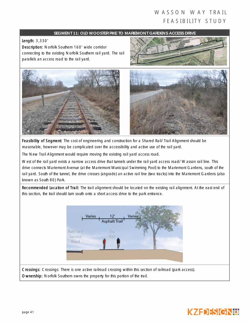
page 41
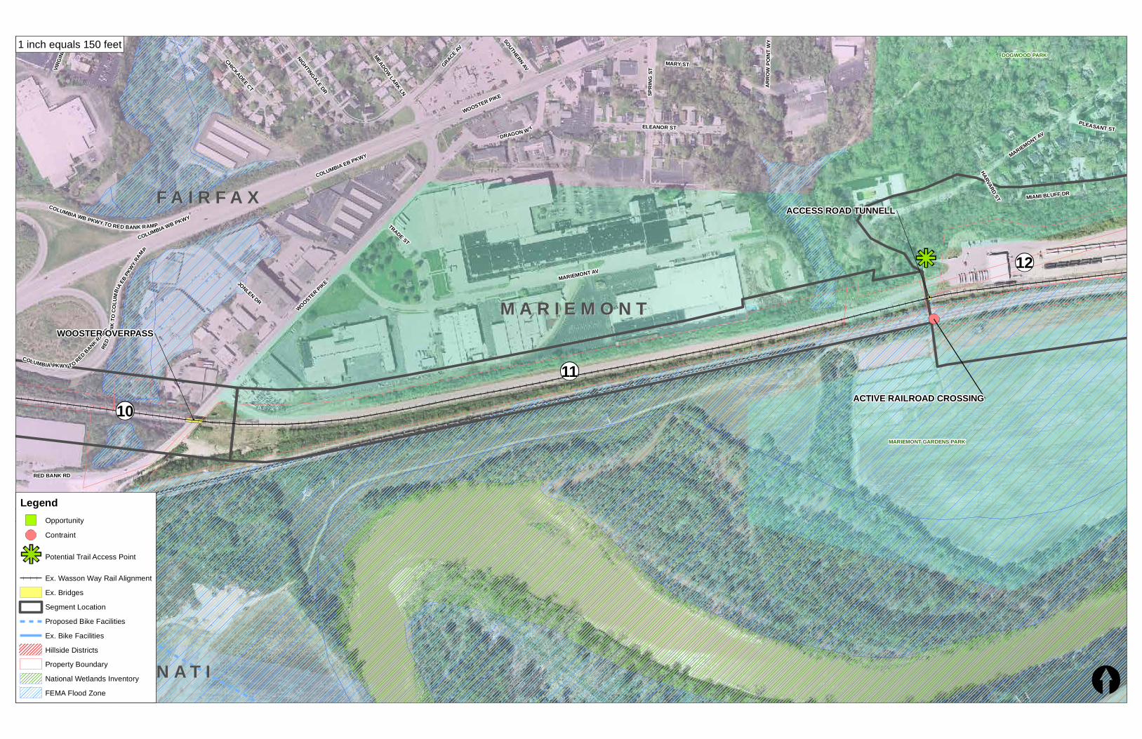
SEGMENT 11: OLD WOOSTER PIKE TO MARIEMONT GARDENS ACCESS DRIVE
Length: 3,330’ Description: Norfolk Southern 160’ wide corridor connecting to the existing Norfolk Southern rail yard. The rail parallels an access road to the rail yard.
Feasibility of Segment: The cost of engineering and construction for a Shared Rail/Trail Alignment should be reasonable, however may be complicated over the accessibility and active use of the rail yard.
The New Trail Alignment would require moving the existing rail yard access road.
West of the rail yard exists a narrow access drive that tunnels under the rail yard access road/Wasson rail line. This drive connects Mariemont Avenue (at the Mariemont Municipal Swimming Pool) to the Mariemont Gardens, south of the rail yard. South of the tunnel, the drive crosses (at-grade) an active rail line (two tracks) into the Mariemont Gardens (also known as South 80) Park.
Recommended Location of Trail: The trail alignment should be located on the existing rail alignment. At the east end of this section, the trail should turn south onto a short access drive to the park entrance.
Crossings: Crossings: There is one active railroad crossing within this section of railroad (park access). Ownership: Norfolk Southern owns the property for this portion of the trail.

MARIEMONT GARDENS PARK
DOGWOOD PARK
M A R I E M O N TM A R I E M O N TF A I R F A XF A I R F A X
MIAMI BLUFF DR
MARIEMONT AV
MT VERNON AV
CEN
TER
ST
PLEASANT ST
CLARE RD
WASHINGTON BLVD
HAMMERSTONE WY
MIAMI RD
PARK
LN
MO
NROE AV
MO
UN
D W
Y
LITTLE MIAMI TER
CA
CH
EPIT
WY
FLIN
TPO
INT
WY
PETO
SKEY
AV
EAST
ST
CRYSTAL SPRINGS RD IND
IAN
VIEW
RD
LINCOLN TER
ALBERT PL
WOOSTER PIKE
MIDD
EN WY
FORT LEE PKWY
HA
RVA
RD
AC
RES
EMER
Y LN
SHELDON CLSE
HARVARD ST
12
11
ACCESS ROAD TUNNELL
RAIL YARD
ACTIVE RAILROAD CROSSING
1 inch equals 150 feet
LegendOpportunity
Contraint
Potential Trail Access Point
Ex. Wasson Way Rail Alignment
Ex. Bridges
Segment Location
Proposed Bike Facilities
Ex. Bike Facilities
Hillside Districts
Property Boundary
National Wetlands Inventory
FEMA Flood Zone

Little Miami Golf Center
AVOCA PARK
M A R I E M O N TM A R I E M O N T
WOOSTER PIKE
5TH AV
1ST AV
4TH AV
MIAMI RUN
WALTON CREEK RD
3RD AV
PETO
SKEY
AV
2ND AV
BEECH ST
ASHLEY O
AKS DR
SPRI
NG S
T
POC
AH
ON
TAS
AV
LOCUST S
T
SPRI
NG H
ILL
DR
MARIEMONT CRSC
ELM ST
LINCOLN TER
MU
CH
MO
RE
RD
FORT LEE PKWY
PEAR LN
NEW
TOW
N RD
ORCHARD ST
SUMTER AV
PAVILION DR
MT VERNON AV
MOORE RD
SPRING KNOLL DR
12
13
POTENTIAL STRUCTURE
POTENTIAL STRUCTURE
EX. FACILITY CONNECTIVITY
1 inch equals 150 feet
LegendOpportunity
Contraint
Potential Trail Access Point
Ex. Wasson Way Rail Alignment
Ex. Bridges
Segment Location
Proposed Bike Facilities
Ex. Bike Facilities
Hillside Districts
Property Boundary
National Wetlands Inventory
FEMA Flood Zone

W A S S O N W A Y T R A I L F E A S I B I L I T Y S T U D Y
page 44
SEGMENT 12: MARIEMONT GARDENS TO SPRING HILL DRIVE
Length: 6,460’ Description: Norfolk Southern rail yard.
Feasibility of Segment: The cost of engineering and construction for a Shared Rail/Trail Alignment should be reasonable, however would be complicated over the accessibility and active use of the rail yard.
Recommended Location of Trail: The trail alignment has two options through this segment:
1. On-road facility – traveling through the tunnel, up to Mariemont Avenue, then through the residential streets of Mariemont (primarily along Miami Bluff Drive) to Wooster Pike. This route would require mostly on-road facilities – bike lanes or sharrows). An off-road facility does not appear feasible, due to potential impacts to the Miami Bluffs and Mariemont Earthworks. At the east side of Mariemont, the trail would need to widen/replace existing sidewalks to connect along Wooster Pike to the commercial entrance opposite Spring Hill Drive.
2. Off-road facility – traveling over the active railroad track into Mariemont Gardens Park (South 80), then east, along the existing gravel path alignment through the park to its eastern border. The trail would then cross under the railroad bridge over the Little Miami River, and run east along the Little Miami River. The railroad consists of four dead-end lines in this area, used for short term rail storage. The steep river bank will require one of these rail lines to be removed to provide room for the trail.
Crossings: There is one active rail crossing in this section, and a crossing under the railroad bridge (Little Miami River). Ownership: Norfolk Southern, Village of Mariemont, private owners and Hamilton Co. Park owns portions of property.

W A S S O N W A Y T R A I L F E A S I B I L I T Y S T U D Y
page 45
SEGMENT 13: SPRING HILL DRIVE TO NEWTOWN ROAD
Length: 6,460’ Description: Trail proceeds along the Little Miami River bank, behind commercial development. This portion of trail has been abandoned, and is owned by the Park District.
Feasibility of Segment: The cost of engineering and construction for a Shared Rail/Trail Alignment should be reasonable due to the relatively flat topography and the fact that the Hamilton County Parks owns the property, however will require the construction of two stream crossings. The western most, near Spring Hill Drive, will require extension of the existing culvert. The Walton Creek Crossing further east will require a small bridge. The eastern terminus for the new trail is at Newtown Road, connecting the southern end of the Little Miami Trail, where it crosses the river.
Recommended Location of Trail: The trail alignment will following the alignment of old rail line.
Crossings: There are no roadway crossings within this section of railroad. Ownership: Hamilton County Parks owns the property.