waste licence application process for waste …
TRANSCRIPT
WASTE LICENCE
APPLICATION PROCESS
FOR WASTE ACTIVITIES
IN TERMS OF THE
NATIONAL
ENVIRONMENTAL
MANAGEMENT :WASTE
ACT 2008 (No. 59 of 2008)
2 of 31
TABLE OF CONTENTS
SECTION 6: GENERAL .......................................................................................................................... 23
Prevailing wind direction (e.g. NWW): See Air Quality report attached in Appendix D9 of EIR ........... 23
The size of population to be served by the facility: .............................................................................. 23
The geological formations underlying the site: .................................................................................... 24
SECTION 7: COMPETENCE TO OPERATE SITE ................................................................................. 24
Legal compliance ................................................................................................................................ 24
Financial Provisions ............................................................................................................................ 28
SECTION 8: LANDFILL PARAMETERS ................................................................................................. 29
The method of disposal of waste: ....................................................................................................... 29
The dimensions of the disposal site in metres .................................................................................... 29
The total volume available for the disposal of waste on the site ......................................................... 29
The total volume already used for waste disposal: ............................................................................. 29
The Salvage method ........................................................................................................................... 30
Fatal Flaws for the site: ....................................................................................................................... 30
Location and depth of ground water monitoring boreholes: ................................................................ 32
Location and depth of landfill gas monitoring test pit: ......................................................................... 33
SECTION 9: DECLARATIONS ................................................................................................................ 34
The independent Environmental Assessment Practitioner .................................................................. 34
The Applicant ...................................................................................................................................... 35
APPENDIX: A1 ........................................................................................................................................... 36
APPENDIX B1 ............................................................................................................................................. 37
APPENDIX B2 ............................................................................................................................................. 38
APPENDIX C: Locality Map......................................................................................................................40 APPENDIX D: Layout Plan..................................................................................................................41 APPENDIX E: Closure & End use plan, Emergency Preparedness and Response Plan..................................................................................................................................................42 APPENDIX F: Final Environmental Impact Report..................................................................................43 APPENDIX G: Bill of Quantities....................................................................................................................44
3 of 31
THE WASTE LICENSING APPLICATION PROCESS IN TERMS OF THE NATIONAL ENVIRONMENTAL MANAGEMENT: WASTE ACT 2008 (No. 59 of 2008) “NEMWA”. PART 1: WASTE ACTIVITIES LICENSING APPLICATION PROCESS EXPLAINED: 1.1 Licensing process:
1.1.1 The waste licensing process for listed activities under Schedule 1 in the National Environment
Management Waste Act 2008 is as defined in the environmental impact assessment (EIA) regulations made under section 24(5) of the National Environment Management Act 2008 (NEMA) No. 107 of 1998.
1.1.2 This application form is the official form in terms of Regulation 13 (2) (a) of the EIA regulations R385
of 2006 and must accompany every licence application pertaining to waste activities in terms of NEMWA.
1.2 Where to submit applications
1.2.1 The Minister of Water and Environmental Affairs is the licensing authority in respect of all activities
listed in both categories of Schedule 1 of NEMWA pertaining to hazardous waste. The application for a waste licence in terms of section 45 of the National Environment Management Waste Act 2008 (59 of 2008) for hazardous waste activities must be submitted by lodging an application with the National Department of Environment. The application must be marked for the attention of: The Director: Authorisation and Waste Disposal Management Private Bag X447 Pretoria 0001 Tel: 012 310 3920 Fax: 012 310 3753
1.2.2 The Member of the Executive Council of a province who is responsible for waste management in the
province “MEC” is the licensing authority in respect of all activities listed in both categories of Schedule 1 of NEMWA pertaining to general waste. The application for a waste licence in terms of section 45 of the National Environment Management Waste Act 2008 (No. 59 of 2008) for general waste activities must be submitted by lodging an application with the relevant provincial department and applications must be marked for the attention of the Head of Department in the relevant province at the following addresses: Head of the Department Department of Environmental Affairs and Development Planning Private Bag X 9086 CAPE TOWN 8000 Fax: 021 483 4425 Tel: 021 483 5109

4 of 31
Head of Department Department of Economic Development and Environmental Affairs Private Bag X 0054 BHISHO 5605 Fax: 040 609 4700 Tel: 040 609 4702 Head of Department Department of Economic Development Tourism and Environment Affairs Private Bag X 20801 BLOEMFONTEIN 9300 Fax: 051 400 4772 Tel: 051 400 4917 Head of Department Department of Agriculture and Rural Development P.O. Box 8769 JOHANNESBURG 2000 Fax: 011 333 0667 Tel: 011 355 1927 Head of Department Department of Agriculture Environmental Affairs and Rural Development Private Bag X 9059 PETERMARITZBURG 3200 Fax: 033 355 9593 Tel: 033 355 9621 Head of Department Department of Economic Development, Environment and Tourism Private Bag X 9484 POLOKWANE 0700 Fax: 015 291 5809 Tel: 015 291 5447 Head of Department Department of Economic Development Environment and Tourism Private Bag X 11219 NELSPRUIT 1200 Fax: 013 766 8445 Tel: 013 766 6063

5 of 31
Head of Department Department of Agriculture, Conservation and Rural Development Private Bag X 2039 MMABATHO 2735 Fax: 018 389 5006 Tel: 018 389 5341 Head of Department Department of Environmental Affairs and Nature Conservation Private Bag X 6102 KIMBERLEY 8300 Fax: (053) 807 7367
1.3 Making an Application 1.3.1 The applicant must fill in all relevant sections of this form. Incomplete applications will not be
processed. The applicant will be notified of the missing information in the acknowledgement letter that will be sent within 14 days of receipt of the application. Sections in the form that do not apply to the applicant must be marked “not applicable”
1.3.2 There is no prescribed fee. 1.3.3 This application form is in effect as of 01 July 2009. It is the responsibility of the
Applicant/Environmental Assessment Practitioner “EAP” to ascertain whether subsequent versions of the form have been published or produced by the licensing authority. It is the applicant’s responsibility to download the current version of the application form from the South African waste information centre website (www.sawic.org.za).
1.3.4 The application form may be submitted electronically and four hardcopies of the form must be
submitted to the Directorate: Authorisation and Waste Disposal Management where the national department is the licensing authority. The applicant must contact the relevant provincial office regarding the number of copies required to process the application where provincial departments are the licensing authorities. All application forms must be signed as stipulated in the form. Applications that are not signed or completed accordingly will not be considered.
1.3.5 Where the national department is the licensing authority, all applications forms must be accompanied
by four copies of reports and other documents required in terms of the EIA Regulations. 1.3.6 Where the provincial department is the licensing authority, all applications forms must be
accompanied by the number of copies required by that province for reports and other documents required in terms of the EIA Regulations.
1.3.7 The applicant must clearly mark confidential sections of the information submitted in the application
form and supporting documents. All other information will become public information on receipt by the licensing authority.

6 of 31
2. DEFINITIONS:
2.1 Definitions in this form are as per EIA Regulation in terms of Chapter 5 of the National Environmental Management Act , 1998 and waste management activities list in terms of the National Environmental Management: Waste Act 2008, No. 59 of 2008.
3. THE WASTE LICENSING APPLICATION STAGES:
3.1 Stage 1: Pre-application
Before making an application:
• The applicant must appoint an EAP in terms of EIA regulations
• The EAP must comply with general requirements as given in EIA regulations
• The EAP may be disqualified in terms of EIA regulations 3.2 Criteria for determining whether basic assessment or scoping is to be applied to applications 3.2.1 Basic assessment must be applied to an application if the authorisation applied for is in respect of an
activity listed in Category A in schedule 1 of the NEMWA (59 of 2008). 3.2.2 Scoping and EIA must be applied to an application if the authorisation applied for is in respect of an
activity listed in Category B in schedule 1 of the NEMWA (59 of 2008).
Rev:0 (01 July 2009) Page 7 of 31
WASTE LICENCE
APPLICATION FORM
PART 2: APPLICATION FORM FOR NEW LICENCE

Rev:0 (01 July 2009) Page 8 of 31
(For official use only) File Reference Number:
Date Received:
Classification:
WASTE LICENCE APPLICATION FORM in terms of the National Environmental Management: Waste Act, 2008 (No. 59 of
2008)
THE APPLICATION FORM MAY BE TYPED OR HAND-WRITTEN.
SECTION 1 – TYPE OF APPLICATION AND FACILITY:
Indicate the type of application by marking with a cross and fill in the required sections only
TYPE OF APPLICATION MARK SECTIONS OF THE FORM TO BE FILLED IN
A new licence X Part 2 and see table of activities below for relevant sections of part 2
A licence amendment
Part 3 and Part 2 only if there are changes to the information or the applicant holds a permit issued in terms of section 20 of ECA (No. 78 of 1989) as amended.
A licence for closure Part 4, Section 2, 3a, 3b, & 3c. of part 2 of this application form
Indicate the type of facility/operation and fill in the required sections only
TYPE OF ACTIVITY MARK SECTIONS OF THE FORM TO BE FILLED IN
Recycling and/or recovery Facility All except Section 8
Storage and or transfer Facility X All except Section 8
Treatment facility All except Section 8
Disposal facility X All
Rev:0 (01 July 2009) Page 9 of 31
Activities applied for An application may be made for more than one listed or specified activity that, together, make up one development proposal. All the listed activities that make up this application must be listed.
INDICATE THE NO. & DATE OF THE RELEVANT NOTICE:
ACTIVITY NUMBERS (AS LISTED IN THE WASTE MANAGEMENT ACTIVITY LIST) :
DESCRIBE EACH LISTED ACTIVITY:
CATEGORY A
GN 718 of 3 July 2009 Category A (1) The storage including the temporary storage of general waste at a facility that has the capacity to store in excess of 100m3 of general waste at any one time, excluding the storage of waste in lagoons
Category A (2) The storage including the temporary storage of hazardous waste at a facility that has a capacity to store in excess of 35m3 of hazardous waste at any one time, excluding the storage of hazardous waste in lagoons
Category A (14) The disposal of inert waste in excess of 25tonnes and with a total capacity of 25 000 tons, excluding the disposal of waste for the purposes of levelling and building which has been authorised by or under other legislation
Category A(15) The disposal of general waste to land covering an area of more than 50m2 but less than 200m2 and with a total capacity not exceeding 25 000 tonnes
Category A(18) The construction of facilities for activities listed in Category A 0f this schedule (not in an isolation to associated activity)
CATEGORY B
Category B (2) The reuse and recycling of hazardous waste
Category B4 (9) The disposal of any quantity of hazardous waste to land
Category B4 (10) The disposal of general waste to land covering an area in excess of 200m2
Category B4 (11) The construction of facilities for activities listed in Category B of this Schedule
NB: Authorisation issued will only cover activities applied for and listed above. Activities added in the middle or after the processing of this authorisation may mean a totally new application.
Application for Category A (equivalent to Basic Assessment) [Application is for Scoping and EIA, inclusive] Is this an application for a basic assessment (as defined in the EIA regulations)? YES NO √
If, YES, is a basic assessment report attached? YES NO
If, NO, please indicate when the basic assessment report will be submitted:
Application is for Scoping and EIA, inclusive], please refer to EIR submitted to DEAT on 07 July 2009 (See Appendix F).
Is information required as per Appendix B1 of this form attached? YES√ NO
If, NO, please ensure that it is submitted together with the basic assessment report (BAR)
Application for Category B (equivalent to Scoping and Environmental Impact Assessment (EIA)) Is this an application for Scoping and EIA (as defined in the EIA regulations)? YES√ NO

Rev:0 (01 July 2009) Page 10 of 31
Please indicate when the Scoping Report and Plan of Study for EIA will be submitted:
Scoping Report and EIA were submitted to DEAT on 07 July 2009, please also refer to supporting documents attached as Appendices C – G of this report
Please ensure that both Appendix B1 and B2 are completed and included in reports
The scoping report and/or the plan of study for EIA will be submitted after consultation with the competent authority [ALREADY SUBMITTED] YES NO√
A consultation with the competent authority is hereby requested: YES NO√
Rev:0 (01 July 2009) Page 11 of 31
SECTION 2: SITE IDENTIFICATION, LOCATION AND LANDUSE Please indicate all the Surveyor-general Cadastral Code 21 digit site (erf/farm/portion) reference numbers: Farm Grootestryd 465 LQ (Matimba Power Station)
T 0 L Q 0 0 0 0 0 0 0 0 0 4 6 5 0 0 0 0 0
1 2 3 4 5 LEGEND: 1. Refers to the Surveyor’s-General Office (T = Pretoria, F = Free State, C = Cape Town & N = Kwazulu-Natal) 2. Major Code (Registration Division) 3. Minor code 4. Property No (i.e. Farm No./Erf No./Holding Area No./Sheme No.) 5. Portion Number
If the property type is not surveyed, complete the following: Full name of leader of village, community or tribal authority N/A
Local Authority N/A
Magisterial District N/A
Tribal Authority/Council N/A
Ownership of the property (mark only one with an X) Property owned by applicant (100% Share value) X Property leased by applicant
Property owned by applicant (Share value less than 100%) The property is communal land

Rev:0 (01 July 2009) Page 12 of 31
Size of Site and Classification
Size of facility for a waste management activity
M
Area where the waste management activity takes place
Lephalale, Matimba Power Station
Classification of facility in terms of climatic water balance
B+
Classification of Facility in terms of the type and the quantity of waste received
G
Current land-use where the site is situated:
Industrial Recreation Agriculture √ Commercial Residential Mining & quarrying Forestry Wilderness areas Wetlands Nature area Open spaces
Other current land-use…………………………………………………………………………………………………………………………………..
MARK YES/NO
SECTION IN THE REPORTS WHERE RELAVANT AUTHORISATION IS ATTACHED
Is a change of land-use or a consent use application required? NO
Must a building plan be submitted to the local authority for approval?
Geographical coordinates of all external corner points of the site: See layout plan (Appendix D) and Appendix C for further details)
Number of corner Latitude Longitude
1 23° 40' 04.5" 27° 35' 35.5"
2 23° 39' 57.9" 27° 35' 41.4"
3 23° 39' 53.2" 27° 35' 56.2"
4 23° 40' 06.7" 27° 36' 00.1"
5 23° 40' 07.6" 27° 36' 00.7"
6 23° 40' 21.7" 27° 36' 00.7"
7 23° 40' 23.4" 27° 36' 00.3"
8 23° 40' 14.9" 27° 35' 48.9"
9 23° 40' 07.9" 27° 35' 53.7"
10 23° 40' 03.0" 27° 35' 45.9"
11 23° 40' 09.3" 27° 35' 41.5"

Rev:0 (01 July 2009) Page 13 of 31
Site Address:
Building Name or Number Farm Grootestryd 465LQ (Matimba Power Station)
Street Off Nelson Mandela Drive (Matimba Power Station)
City/Closest Town Lephalale
Province Limpopo Province
Local Municipality Lephalale Local Municipality
District Municipality Waterberg District Municipality
Property Description (Deeds Act or name of farm, town, city or agricultural holding Farm Grootestryd 465 LQ
Postal address Private Bag X215
Lephalale
Postal code: 0555 Cell:
Telephone: 014-763 8200 Fax: 014-763 3616
E-mail: [email protected]
Local authority in whose jurisdiction the proposed activity will fall:
Lephalale Local Municipality
Contact person: Meisie Manthata
Postal address: P.O.Box X136, Lephalale
Postal code: 0555 Cell:
Telephone: 014 762 1432 Fax: 014 762 1506
E-mail: [email protected]
In instances where there is more than one local authority involved, please attach a list of local authorities with the contact person and contact details to this application.
SECTION 3: CONTACT INFORMATION A) Person to contact about application (EAP)
First name & Surname Karthigesan Govender
Company name (if any): Envirolution Consulting (Pty) Ltd Company Registration/Identity number for individuals 2001/029956/07
Physical address: 04 Peltier Road, Sunninghill Office Park, Johannesburg
Postal address: P.O.Box 1898, Sunninghill,
Postal code: 2157 Cell: 083 419 8905
Telephone: 0861 44 44 99 Fax: 0861 62 62 22

Rev:0 (01 July 2009) Page 14 of 31
Email Address [email protected]
B) Person wishing to hold licence
First name & Surname of Applicant Deidre Herbst
Company name (if any): Eskom Holdings Limited (Eskom Generation Division)
Company Registration/Identity number for individuals
2002/015527/06
Physical address Eskom Megawatt Park, 1 Maxwell Drive, Sunninghill, Johannesburg
Postal address P.O.Box 1091, Sunninghill, Johannesburg
Postal code: 2157
Cell: 083 660 1147
Telephone: 011 800 3501 Fax: 011 800 5140
E-mail: [email protected]
C) Landowner where activity takes place
First name & Surname Christo Van Niekerk
Company name (if any): Matimba Power Station
Company Registration/Identity number for individual(s)
2002/015527/06
Physical address Farm Grootestryd 465 LQ, Off Nelson Mandela Drive, Matimba Power Station
Postal address Private Bag X 215 Lephalale 0555
Cell:
Telephone: 014-763 8200 Fax: 014-763 3616
E-mail: [email protected]
Operational times
PERIOD FROM UNTIL
Weekdays 07h00 17h00
Saturdays 08h00 13h00
Sunday 08h00 13h00
Public holidays 08h00 13h00
Rev:0 (01 July 2009) Page 15 of 31
SECTION 4: PROCESS/ACTIVITY DESCRIPTION:
Project Title LICENSE APPLICATION FOR THE PROPOSED CONSTRUCTION OF AN ESKOM GENERAL LANDFILL, A LOW HAZARDOUS WASTE CELL AND HIGH LEVEL TEMPORARY HAZARDOUS FACILITY IN LEPHALALE, LIMPOPO PROVINCE
Project Description:
Please provide a brief description of the activities and operations at the site. Provide a flow chart of the operation showing all inputs and outputs of the process. Give particulars of the source, location, nature, composition and quantity of emission to the atmosphere, surface water, sewer, and ground-water including noise emissions. Solid waste must be in tons and specify units for liquids and gases. Eskom Holdings Limited (Eskom) is proposing to establish a general waste disposal site, a temporary hazardous waste storage facility and a low hazardous waste cell on a site located within the boundaries of Matimba Power Station in Lephalale, Limpopo Province, see locality map (Appendix C). The waste disposal site will accommodate waste from the
Matimba Power Station, the Medupi Power Station presently under construction and the two Waterberg Coal Fired Stations being proposed. In addition, it will also cater for the waste that will be generated by an Eskom Contractor’s Village (accommodation camp for appointed Eskom Contractors based in Lephalale) which will accommodate approximately 8000
contractor personnel. The nature and extent of this facility, as well as potential environmental impacts associated with the
construction of a facility of this nature is explored in more detail in the Environmental Impact Report (EIR) that was submitted to DWAE on 26 June 2009. Eskom is presently constructing a 6 x 800MW (4 800MW total capacity) coal fired power station. The power station is known as the Medupi Power Station, located approximately 15km from the town of Lephalale in the Limpopo Province. The construction of the Medupi Power Station results in the generation of enormous amounts of waste (both general and hazardous). It should be
noted that the waste disposal site which exists at the town of Lephalale is not licensed and therefore, in terms of Eskom’s Safety Health and Environment (SHE) Policy and commitment to legal compliance, cannot currently be utilised for disposal of the waste generated. It is further a requirement by the National Environmental Management Waste Act 59 of 2008 that a waste license be obtained from the Department of Water and Environmental Affairs (DWEA) for the proposed development. As a result Eskom is
obliged to have all Medupi waste transported to the Gauteng area to ensure disposal at a licensed site. During the construction of the Medupi Power Station, it is anticipated that construction waste will be generated until 2014, after which the station will become operational. Approximately half of the construction and operational waste will be hazardous waste, and half general waste. It is anticipated that the existing Matimba Power Station will generate the same amount of waste, with a 50% split between hazardous and general waste for the remainder of its operating life, whereas the two proposed Waterberg Coal Fired Power Stations are anticipated to generate waste volumes that are slightly higher than that of the Medupi Power Station. The Waterberg Power Stations are anticipated to have a life span of approximately 50 years. The total anticipated waste generated from the four power stations over their total life i.e. 50 years, is expected to be approximately 1 200 000m3 of waste split between general and hazardous waste. Given the approximate waste volumes that will be generated from the four power stations and the contractor’s village, the
proposed development is a strategic response to address the following:
• current waste management challenges facing Eskom in the Lephalale area,
• Adherence to the legal requirements, and
• Combating current operating costs.
Rev:0 (01 July 2009) Page 16 of 31
2. Waste Generation and Waste Streams The quantities of various types or categories of waste generated at the existing Matimba and new Medupi Power Station including two additional future powerstation (Coal 3 and 4) in the area has a direct impact on the type, class, size and nature of both the landfill site and the temporary hazardous storage facility. In order to estimate the waste generation at these power stations, waste generation data from other Eskom power stations within South Africa has been utilised coupled with the provided records of current waste generation figures from Matimba power station (operational) and Medupi construction phase. Further to this, projection of future waste generation has been undertaken taking into consideration growth and future potential sources within area. The types of waste, generated by Eskom in Lephalale, are linked to its activities in the areas. The Medupi power station currently under construction and the Matimba power station is generating the following waste streams: • Land clearing debris • Wood and wooden pallets • Broken bricks (builders rubble general) • Concrete • Concrete masonry units • Glass • Scrap Metal • Beverage Cans • Plastics • Cardboard • Paper and Newsprint • Food residue waste The hazardous waste stream includes: • Used Oil • Oil contaminated waste (oily rags, tins etc) • Grease • Florescent Tubes • Used Chemicals • Chemical contaminated containers • Cleaning liquids and detergents • Bituminous substances • Paints • Thinners • E-Waste • Medical Waste (Health Care Risk Waste) • Sewage Sludge • Printer cartridges • Filtration Devices • Brine These general and the hazardous waste streams at Eskom Medupi power station can be directly linked to the various project phases i.e. construction phase, operation phase and decommissioning phase. Currently the Medupi project is in its construction phase and hence the major sources of general and hazardous waste are summarised as follows:
• Construction phase

Rev:0 (01 July 2009) Page 17 of 31
Based on Medupi scenario, it is estimated that the construction peak for the powerstations, will have over 8000 workers on site. Using a conservative rate of 0.75kg/p/day and density of un-compacted waste of 0.131 Tonnes/m3, The existing Matimba, Medupi and Coal 3 and 4 power stations are likely to generate in excess of 43m3 of waste per day which equates to approximately 858m3 per month. However it should be noted that this will drop significantly once construction has ended.
Waste generation estimates during the construction phase for Matimba, Medupi and proposed Coal 3 and Coal 4 power stations (Roshcon) (this map is presenting parallel construction process, and does not show possible phasing of the construction of these power stations)
• Operational Phase
The tables below show estimated waste generation during the operation phase of the existing Matimba, Medupi, Coal 3 and
Coal 4 power stations.
General Waste
BU
Ash Ash General Waste
Building rubble
Printing Cartridges
Conveyer belts (m)
Garden Refuse Paper Metals
Kt tonnes tonnes tonnes (number) Meter (m)
tonnes kg tonnes
P P P P R R
P R R
Monthly average 214.6 214550.8 363.9 62.7
15.8 401.5 14867.7
Matimba Monthly 428.8 428794.0 192.3 0.0
54 292 0.036 29201058.3 194.44119.6
Medupi Estimated 214.6 214550.8 363.9 62.7
15.8 401.5 14867.7
Coal 3 Estimated 214.6 214550.8 363.9 62.7
15.8 401.5 14867.7
Coal 4 Estimated 214.6 214550.8 363.9 62.7
15.8 401.5 14867.7
Total Estimated 1072.4 1072446.3 1283.9 188.1 47.4 2262.8 44722.6
Rev:0 (01 July 2009) Page 18 of 31
Total for Land Filling (tonnes) 1073965.7
194440
P=produced, R= recycled
Hazardous Waste
BU
Asbestos Medical Waste FFB's
Fluorescent tubes Waste oil Waste Grease
Tonnes kg m3 210 liter drums Liters Liters
P P P P R R
Monthly average 10.8 8.3 334.3 1.4 3736.7 427.4
Matimba Monthly 0.0 9.2 0.0 26 11100.0 3710.0
Medupi Estimated 10.8 8.3 334.3 1.4 3736.7 427.4
Coal 3 10.8 8.3 334.3 1.4 3736.7 427.4
Coal 4 10.8 8.3 334.3 1.4 3736.7 427.4
Total Estimated 32.4 29.3 1002.9 6.7 22310.2 4992.3
Total for Land Filling (tonnes) 1035.6 P=produced, R= recycled
Matimba monthly waste generation was compared with the average for all power stations in South Africa. The waste generation at Medupi, Coal 3 and Coal 4 are based on the above averages
3. Conceptual design and Water balance
From the waste stream analysis, discussions with Eskom and climatic water balance calculation the Eskom landfill classification for general waste handling is G:M:B+. As part of the DWAF Minimum Requirements, there is a requirement that the potential for leachate emanating from a waste body be assessed. A water balance calculation was also considered for this development. Water balance typically refers to the inflows and outflows of water from a system. Several elements contribute to water balance and include additionally in the case of land filling, rainfall, evaporation, moisture content of incoming waste and water, ingress into the waste, this last factor arising most likely from poor landfill site selection, design and operation. The rainfall and evaporation figures (using the weather station A4E001, Vaalwater) were examined and negative figures obtained for every season from 1973 to 1966 for which reliable and complete data was kept. The raw data used to make these calculations is attached as Appendix C3 of the EIR. The proposed site (based on the evaporation data) therefore lies in an area where sporadic or no significant leachate is expected to be generated from landfilling. 4. Site Layout The site layout design comprises plans and sections, indicating existing, excavated and final contours. Additionally there will be necessary services and permanent infrastructure at the site. See attached layout plan (Appendix D) for details. The general waste landfill and the hazardous waste cell will be physically separated, refer to Layout plan. The site layout has been designed with the landfill's closure and end-use closely in mind. The end-use, in particular, may decide the final shape or contours of the landfill, and this may influence the site layout and the Operating Plan. 5. Temporary hazardous waste storage facility
Rev:0 (01 July 2009) Page 19 of 31
High hazard rating waste (H:H) will be temporarily stored at the disposal facility for onward transport and disposal to a permitted H:H facility i.e. a facility accepting high hazard rating waste. The high hazard rating waste is not expected to constitute a high proportion of the hazardous waste and therefore this temporary hazardous waste storage facility for the high hazard waste is not expected to be very large. See Appendix D for further details on the temporary hazardous waste storage facility and attached layout plan for location. 6. Landfill Lining A mandatory physical separation between the waste body and the ground water regimes is fundamental to all designs. In order to create a separation or physical barrier between the landfill and the environment in which it is placed, there is a requirement that the landfill be lined. The extent and nature of lining is defined by the expected impact the waste body might have on its environment. See attached layout plan for further details on the liners to be used for the landfill and the leachate dams.
The DWAF Minimum Requirements specifies liner design for different classes of landfill. The proposed lining for a medium landfill designated B+ is indicated below. Please refer to Appendix C1 for further information on general landfill lining. 7. Hazardous Waste Cell Lining The liner requirements for the hazardous waste cell are, as expected, more stringent and include additionally a soil protection layer and a Flexible Membrane Layer/Geomembrane, please refer to the diagram on the next page.
Rev:0 (01 July 2009) Page 20 of 31
As for the general waste lining the clay liner would also be substituted with a GCL liner. Anchor trenches will be constructed to hold the liner down and the hazardous cell will be separated from the general waste landfill and suitable access roads will be constructed. Additionally control berms will be built to manage operations at the hazardous cell. 8. Leachate Collection and Management Leachate collection is usually achieved using a graded underliner and drains which lead to a collection point or sump. Depending on soil quality, the underliner may be an engineered low permeability natural soil or clay liner, a geomembrane liner, or both. The leachate collection system is a system of drains, bunds or trenches covered by the leachate collection layer. It is equipped with suitable drains or collection pipes that direct the gravity flow of leachate or leakage to defined collection points or sumps, from which it can be collected for treatment. Although the general waste landfill site is designated B+, it has the potential to generate sporadic leachate and a leachate collection system has been incorporated into the design. A leachate collection system will out of necessity be incorporated as part of the single hazardous cell design. See Appendix C2 for information on leachate collection and treatment. The leachate treatment system is dependent on the leachate composition and on the most appropriate method of treatment. This could be on-site chemical, physical or biological treatment, and/or off-site treatment where leachate is passed into a sewer or pipeline for treatment elsewhere. It is a Minimum Requirement that all hazardous waste and G:B+ landfills have leachate treatment facilities acceptable to the Department. 9. Groundwater Monitoring A groundwater monitoring system will be in place to measure any contamination arising from either the general waste landfill or the hazardous cell. As part of detailed geophysical testing, the geohydrologist will carry out geophysical and undertake the drilling of rotary percussion boreholes at strategic location, see Appendix D3 for the geohydrological report also showing the location of the boreholes. Groundwater monitoring will be carried out twice a year as per DWAF’s Minimum Requirements documents and/or the Integrated Water Use Licence. 10. Stormwater Management and operations (See attached layout for further details) The site design and operations will be optimised to ensure that as much of the clean stormwater arriving at the site is immediately diverted off and away from the site and not exposed to any contaminated leachate. Any stormwater that does run onto the site will be managed. To this end a contaminated stormwater dam will be specified in the design with a 0.5m freeboard and designed to withstand a 1 in 50 year flood event. Any clean uncontaminated water, which has not been in contact with the waste but has ended up on the site, must be allowed to flow off the site into the natural drainage system. Drains for clean water run-off will be designed to this end. These drains will be maintained to ensure that that they are not blocked by silt or vegetation
Rev:0 (01 July 2009) Page 21 of 31
11. Availability of cover material At the farm Grootestryd i.e. the proposed site, the sequence of sandstone and mudstone and shale rocks is overlain by dark brown sandy transported soils that extend to depths of 4m to 5m below the surface level. Furthermore, highly to completely weathered soft rock sandstone underlies the soils and extends to depths varying between 13m and 15m. This means that the potential for securing cover material is fairly good at this site and excavation operations are likely to be easier here. If necessary, cover material may need to be imported from elsewhere or even purchased and stockpiled on the site. Given the small daily disposal volumes and requirement for daily covering, cover material requirements are expected to be high at the site. Soil profiles exposed in test pits excavated for the geotechnical investigation at the site should be investigated to determine the composition geohydrological properties of the materials overlying the bedrock and the materials used for cover. See Appendix D1 (Geotechnical report) for the geotechnical suitability. 12. Monitoring systems Monitoring systems for surface and ground water pollution are indicated in the layout plan. This includes the positions of both surface water sampling points and monitoring boreholes (See Appendix D3, Geohydrology report for further details. Gas management and gas and air quality monitoring systems are required if, in the Site Investigation and the Risk Assessment, landfill gas migration and accumulation are to represent a potential safety hazard or odour problem, or if an operating or closed site is situated within 250m of residential or other structures. The location of gas monitoring systems could comprise gas monitoring boreholes (see Section 8 of this application form) or other monitoring devices approved by the Department. Positions are indicated on the layout plan. ( 13.Rehabilitation, Closure and End use plans Rehabilitation, closure and end use plan are attached as Appendix E of this report.
Rev:0 (01 July 2009) Page 22 of 31
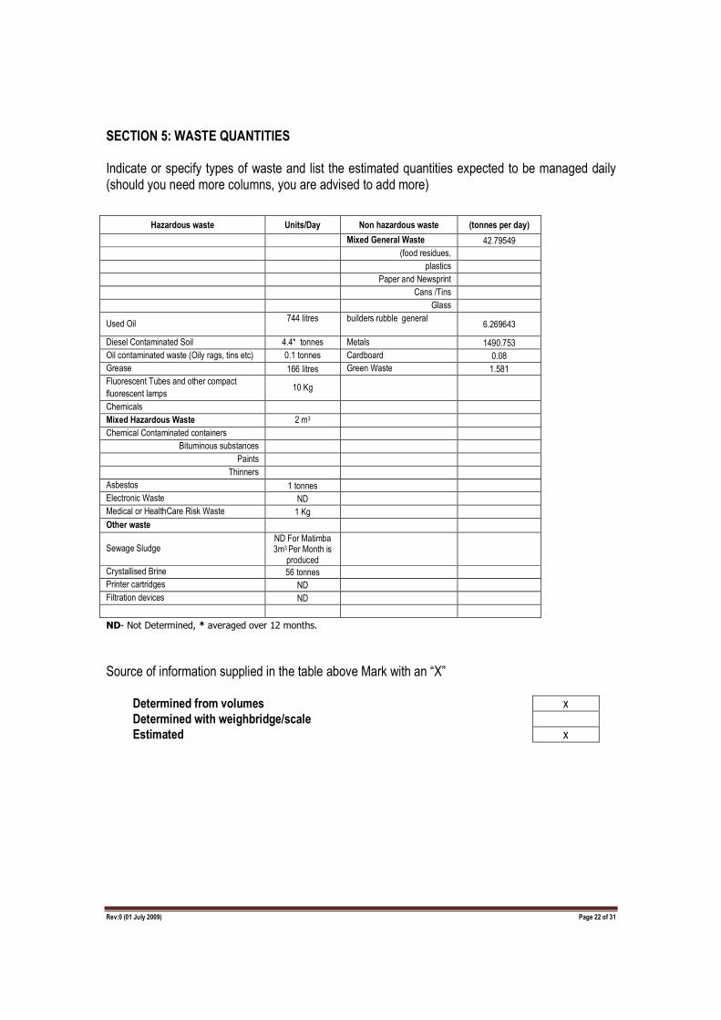
SECTION 5: WASTE QUANTITIES Indicate or specify types of waste and list the estimated quantities expected to be managed daily (should you need more columns, you are advised to add more)
ND- Not Determined, * averaged over 12 months.
Source of information supplied in the table above Mark with an “X” Determined from volumes x
Determined with weighbridge/scale
Estimated x
Hazardous waste Units/Day Non hazardous waste (tonnes per day)
Mixed General Waste 42.79549
(food residues,
plastics
Paper and Newsprint
Cans /Tins
Glass
Used Oil 744 litres
builders rubble general
6.269643
Diesel Contaminated Soil 4.4* tonnes Metals 1490.753
Oil contaminated waste (Oily rags, tins etc) 0.1 tonnes Cardboard 0.08
Grease 166 litres Green Waste 1.581
Fluorescent Tubes and other compact
fluorescent lamps 10 Kg
Chemicals
Mixed Hazardous Waste 2 m3
Chemical Contaminated containers
Bituminous substances
Paints
Thinners
Asbestos 1 tonnes
Electronic Waste ND
Medical or HealthCare Risk Waste 1 Kg
Other waste
Sewage Sludge ND For Matimba 3m3 Per Month is
produced
Crystallised Brine 56 tonnes
Printer cartridges ND
Filtration devices ND
Rev:0 (01 July 2009) Page 23 of 31
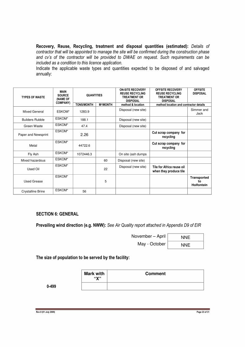
Recovery, Reuse, Recycling, treatment and disposal quantities (estimated): Details of contractor that will be appointed to manage the site will be confirmed during the construction phase and cv’s of the contractor will be provided to DWAE on request. Such requirements can be included as a condition to this licence application. Indicate the applicable waste types and quantities expected to be disposed of and salvaged annually:
TYPES OF WASTE
MAIN SOURCE (NAME OF COMPANY)
QUANTITIES
ON-SITE RECOVERY REUSE RECYCLING TREATMENT OR
DISPOSAL
OFFSITE RECOVERY REUSE RECYCLING TREATMENT OR
DISPOSAL
OFFSITE DISPOSAL
TONS/MONTH M3/MONTH method & location method location and contractor details
Mixed General ESKOM* 1283.9 Disposal (new site) Simmer and
Jack
Builders Rubble ESKOM* 188.1 Disposal (new site)
Green Waste ESKOM* 47.4 Disposal (new site)
Paper and Newsprint ESKOM*
2.26 Cut scrap company for
recycling
Metal ESKOM*
44722.6 Cut scrap company for
recycling
Fly Ash ESKOM* 1072446.3 On site (ash dumps
Mixed hazardous ESKOM* 60 Disposal (new site)
Used Oil ESKOM*
22 Disposal (new site) Tile for Africa reuse oil
when they produce tile
Used Grease
ESKOM* 5
Transported to
Holfontein
Crystalline Brine ESKOM* 56
SECTION 6: GENERAL
Prevailing wind direction (e.g. NWW): See Air Quality report attached in Appendix D9 of EIR
November – April NNE
May - October NNE
The size of population to be served by the facility:
Mark with “X”
Comment
0-499

Rev:0 (01 July 2009) Page 24 of 31
500-9,999 X
Please note, landfill will only accommodate Eskom waste and will not accommodate waste from external parties
10,000-199,999
200,000 upwards
The geological formations underlying the site:
Granite No Quartzite No
Shale Yes Dolomite No
Sandstone Yes Dolerite No
Other____________________________________________________________________________________________
SECTION 7: COMPETENCE TO OPERATE SITE
It is imperative that the holder of the waste licence is a fit person in terms of section 59 of the
NEMWA (59 of 2008). To assess the holder’s competence to operate the site, please disclose the
following:
Legal compliance
YES/NO DETAILS Has the applicant ever been found guilty or issued with a non compliance notice in terms of any national environmental management legislation?
NO
Has the applicant’s licence in terms of the Waste Act 2008 ever been revoked?
NO
Has the applicant ever been issued with a non compliance notice or letter in terms of any South African Law?
NO

Rev:0 (01 July 2009) Page 25 of 31
NB: Details required above include any information that the applicant wants the Department to take into consideration in determining whether they are a “fit person” and this includes reasons why the offence happened and measures in place to prevent recurrence
Rev:0 (01 July 2009) Page 26 of 31
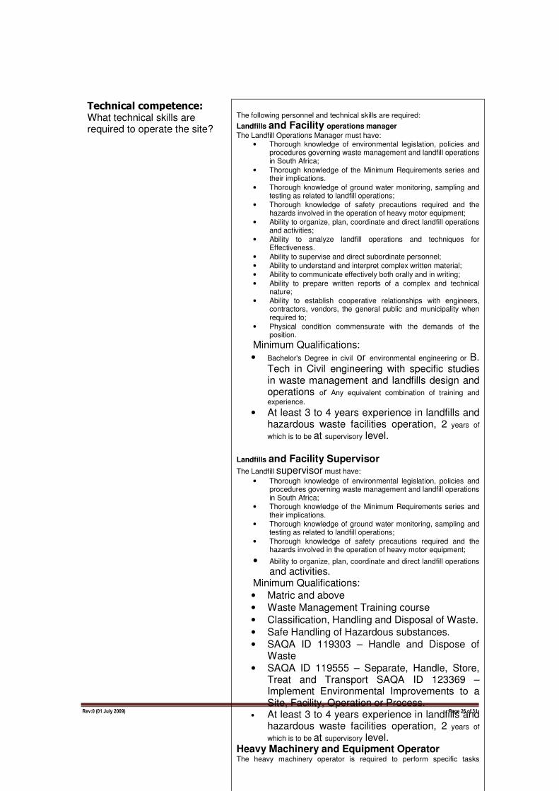
Technical competence: What technical skills are required to operate the site?
The following personnel and technical skills are required:
Landfills and Facility operations manager
The Landfill Operations Manager must have: • Thorough knowledge of environmental legislation, policies and
procedures governing waste management and landfill operations in South Africa;
• Thorough knowledge of the Minimum Requirements series and their implications.
• Thorough knowledge of ground water monitoring, sampling and testing as related to landfill operations;
• Thorough knowledge of safety precautions required and the hazards involved in the operation of heavy motor equipment;
• Ability to organize, plan, coordinate and direct landfill operations and activities;
• Ability to analyze landfill operations and techniques for Effectiveness.
• Ability to supervise and direct subordinate personnel;
• Ability to understand and interpret complex written material;
• Ability to communicate effectively both orally and in writing;
• Ability to prepare written reports of a complex and technical nature;
• Ability to establish cooperative relationships with engineers, contractors, vendors, the general public and municipality when required to;
• Physical condition commensurate with the demands of the position.
Minimum Qualifications:
• Bachelor's Degree in civil or environmental engineering or B. Tech in Civil engineering with specific studies in waste management and landfills design and operations or Any equivalent combination of training and
experience. • At least 3 to 4 years experience in landfills and
hazardous waste facilities operation, 2 years of
which is to be at supervisory level. Landfills and Facility Supervisor
The Landfill supervisor must have:
• Thorough knowledge of environmental legislation, policies and procedures governing waste management and landfill operations in South Africa;
• Thorough knowledge of the Minimum Requirements series and their implications.
• Thorough knowledge of ground water monitoring, sampling and testing as related to landfill operations;
• Thorough knowledge of safety precautions required and the hazards involved in the operation of heavy motor equipment;
• Ability to organize, plan, coordinate and direct landfill operations
and activities. Minimum Qualifications:
• Matric and above
• Waste Management Training course
• Classification, Handling and Disposal of Waste.
• Safe Handling of Hazardous substances.
• SAQA ID 119303 – Handle and Dispose of Waste
• SAQA ID 119555 – Separate, Handle, Store, Treat and Transport SAQA ID 123369 – Implement Environmental Improvements to a Site, Facility, Operation or Process.
• At least 3 to 4 years experience in landfills and hazardous waste facilities operation, 2 years of
which is to be at supervisory level. Heavy Machinery and Equipment Operator
The heavy machinery operator is required to perform specific tasks
Rev:0 (01 July 2009) Page 27 of 31
How will the applicant ensure and maintain technical competency in the operation of the site?
• ESKOM shall ensure that the key positions (Landfills and
Facility Operations Manger, Supervisor, and Heavy Machinery
Operator) are advertised in paper and filled by competent and
suitably qualified people.
• ESKOM shall ensure that all personnel on the site undergo specific waste management training e.g. in the courses highlighted above as well other available waste management courses to ensure continuous professional development CPD.
• ESKOM Shall ensure all personnel on site are inducted through the operations manual and specific training prior to commencement of work on the site.
Details of applicant’s experience and qualification along with that of relevant employees must be summarised as shown in the table below: Details of contractor that will be appointed to manage the site will be confirmed during the construction phase and cv’s of the contractor will be provided to DWAE on request. Such requirements can be included as a condition to this license application.
NAME POSITION DUTIES AND RESPONSIBILITIES QUALIFICATIONS AND EXPERIENCE
Rev:0 (01 July 2009) Page 28 of 31
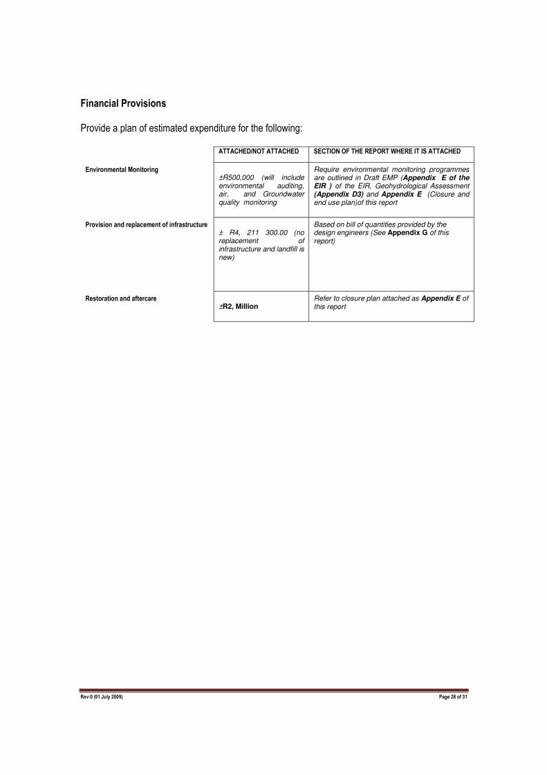
Financial Provisions
Provide a plan of estimated expenditure for the following: ATTACHED/NOT ATTACHED SECTION OF THE REPORT WHERE IT IS ATTACHED
Environmental Monitoring ±R500,000 (will include environmental auditing, air, and Groundwater quality monitoring
Require environmental monitoring programmes are outlined in Draft EMP (Appendix E of the EIR ) of the EIR, Geohydrological Assessment (Appendix D3) and Appendix E (Closure and end use plan)of this report
Provision and replacement of infrastructure ± R4, 211 300.00 (no replacement of infrastructure and landfill is new)
Based on bill of quantities provided by the design engineers (See Appendix G of this report)
Restoration and aftercare ±R2, Million
Refer to closure plan attached as Appendix E of this report
Rev:0 (01 July 2009) Page 29 of 31
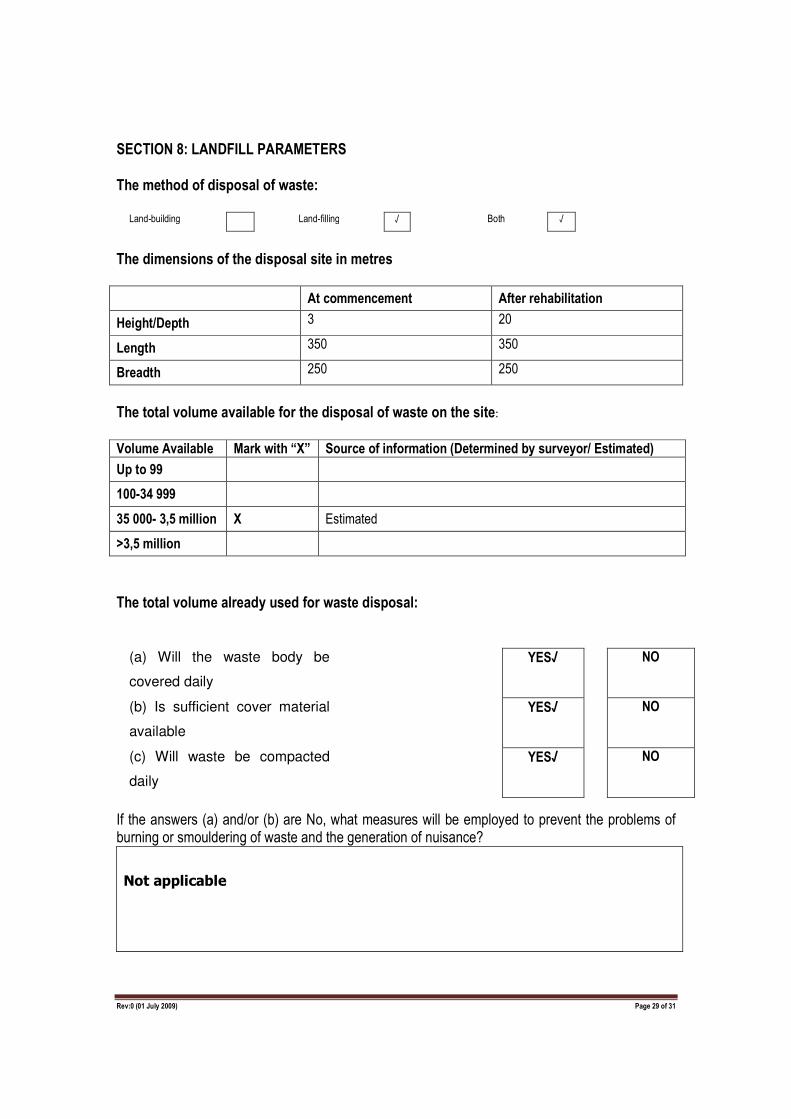
SECTION 8: LANDFILL PARAMETERS
The method of disposal of waste:
Land-building Land-filling √ Both √
The dimensions of the disposal site in metres
At commencement After rehabilitation
Height/Depth 3 20
Length 350 350
Breadth 250 250
The total volume available for the disposal of waste on the site:
Volume Available Mark with “X” Source of information (Determined by surveyor/ Estimated)
Up to 99
100-34 999
35 000- 3,5 million X Estimated
>3,5 million
The total volume already used for waste disposal:
(a) Will the waste body be
covered daily
YES√ NO
(b) Is sufficient cover material
available
YES√ NO
(c) Will waste be compacted
daily
YES√ NO
If the answers (a) and/or (b) are No, what measures will be employed to prevent the problems of burning or smouldering of waste and the generation of nuisance?
Not applicable
Rev:0 (01 July 2009) Page 30 of 31
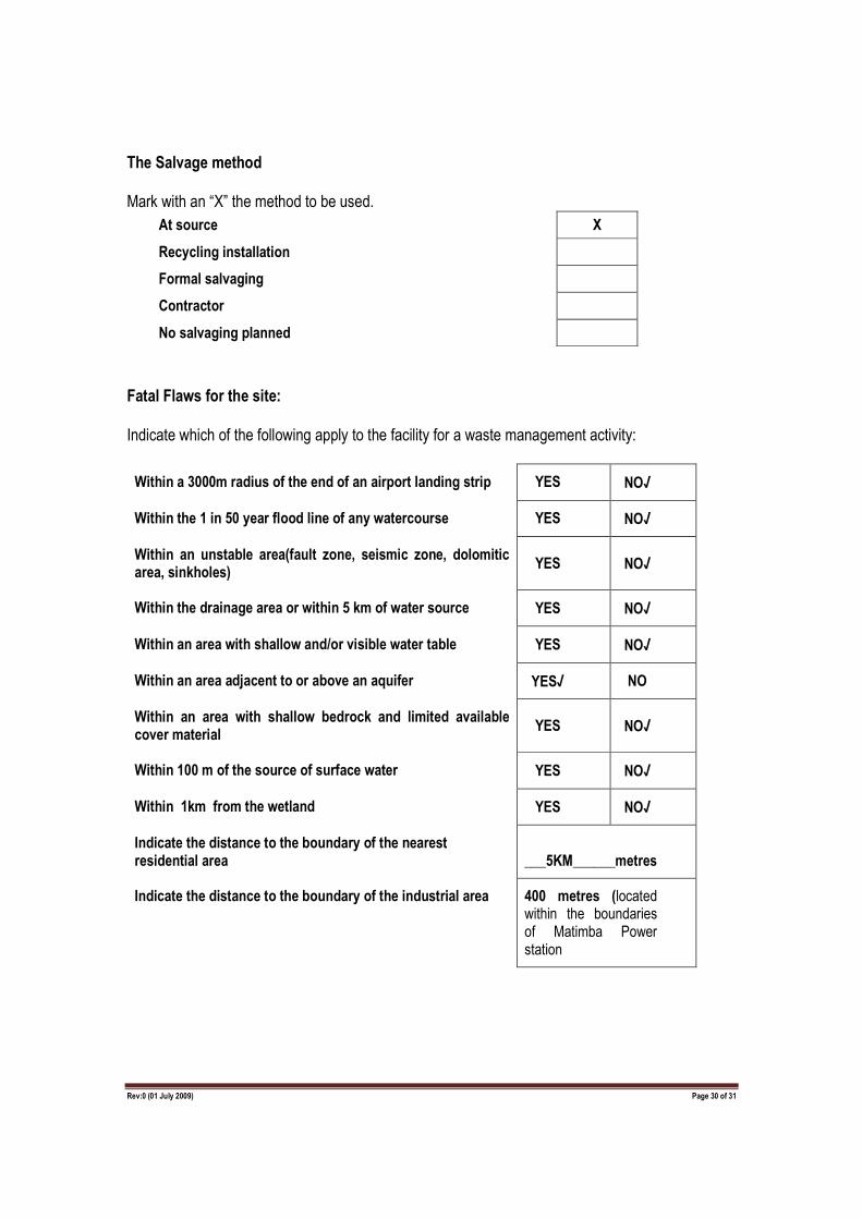
The Salvage method
Mark with an “X” the method to be used.
At source X
Recycling installation
Formal salvaging
Contractor
No salvaging planned
Fatal Flaws for the site:
Indicate which of the following apply to the facility for a waste management activity:
Within a 3000m radius of the end of an airport landing strip YES NO√
Within the 1 in 50 year flood line of any watercourse YES NO√
Within an unstable area(fault zone, seismic zone, dolomitic area, sinkholes)
YES NO√
Within the drainage area or within 5 km of water source YES NO√
Within an area with shallow and/or visible water table YES NO√
Within an area adjacent to or above an aquifer YES√ NO
Within an area with shallow bedrock and limited available cover material
YES NO√
Within 100 m of the source of surface water YES NO√
Within 1km from the wetland YES NO√
Indicate the distance to the boundary of the nearest residential area ___5KM______metres
Indicate the distance to the boundary of the industrial area 400 metres (located within the boundaries of Matimba Power station

Rev:0 (01 July 2009) Page 31 of 31
Wettest six months of the year: Also see Figure 4.2 of the EIR
November- April December, January and February
May -October May, Oct, November
For the wettest six month period indicated above, indicate the following for the preceding 30 years
Total rainfall for
6 months
Total A-pan evaporation for 6
months
Climatic water
balance
For the 1st wettest year
1050.8 1752.1 -701.3
For the 2nd wettest year
899.2 1835.1 -935.9
For the 3rd wettest year
888.5 1728.9 -840.4
For the 4th wettest year
868.5 1979.7 -1111.2
For the 5th wettest year
831.6 1973.8 -1142.2
For the 6th wettest year
796.3 1777.6 -981.7
For the 7th wettest year
789.5 1841.7 -1052.2
For the 8th wettest year
782.7 1712.9 -930.2
For the 9th wettest year
760.5 1842.7 -1082.2
For the 10th wettest year
725.3 1669.0 -943.7
Rev:0 (01 July 2009) Page 32 of 31
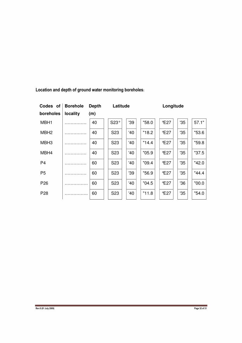
Location and depth of ground water monitoring boreholes:
Codes of
boreholes
Borehole
locality
Depth
(m)
Latitude Longitude
MBH1 …………… 40 S23° '39 "58.0 °E27 '35 57.1"
MBH2 …………… 40 S23 '40 "18.2 °E27 '35 "53.6
MBH3 …………… 40 S23 '40 "14.4 °E27 '35 "59.8
MBH4 …………… 40 S23 '40 "05.9 °E27 '35 "37.5
P4 …………… 60 S23 '40 "09.4 °E27 '35 "42.0
P5 …………… 60 S23 '39 "56.9 °E27 '35 "44.4
P26 ……………. 60 S23 '40 "04.5 °E27 '36 "00.0
P28 ……………. 60 S23 '40 "11.8 °E27 '35 "54.0
Rev:0 (01 July 2009) Page 33 of 31
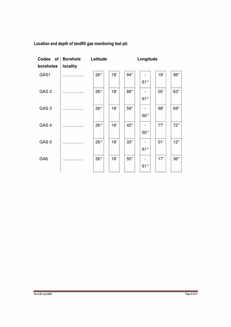
Location and depth of landfill gas monitoring test pit:
Codes of
boreholes
Borehole
locality
Latitude Longitude
GAS1 …………… 26° 18' 94" -
61°
18' 96"
GAS 2 …………… 26° 18' 89" -
61°
00' 63"
GAS 3 …………… 26° 18' 59" -
60°
98' 69"
GAS 4 …………… 26° 18' 42" -
60°
77' 72"
GAS 5 …………… 26° 18' 33" -
61°
01' 12"
GA6 …………… 26° 18' 55" -
61°
17' 36"
Rev:0 (01 July 2009) Page 34 of 31
SECTION 9: DECLARATIONS
The independent Environmental Assessment Practitioner
I, Karthigesan Govender, declare under oath that I –
• act as the independent environmental assessment practitioner in this application ;
• do not have and will not have any financial interest in the undertaking of the activity, other than remuneration for work performed in terms of the Environmental Impact Assessment Regulations, 2006;
• have and will not have no vested interest in the proposed activity proceeding;
• have no, and will not engage in, conflicting interests in the undertaking of the activity;
• undertake to disclose, to the competent authority, any material information that have or may have the potential to influence the decision of the competent authority or the objectivity of any report, plan or document required in terms of the Environmental Impact Assessment Regulations, 2006;
• will ensure that information containing all relevant facts in respect of the application is distributed or made available to interested and affected parties and the public and that participation by interested and affected parties is facilitated in such a manner that all interested and affected parties will be provided with a reasonable opportunity to participate and to provide comments on documents that are produced to support the application;
• will ensure that the comments of all interested and affected parties are considered and recorded in reports that are submitted to the competent authority in respect of the application, provided that comments that are made by interested and affected parties in respect of a final report that will be submitted to the competent authority may be attached to the report without further amendment to the report;
• will keep a register of all interested and affected parties that participated in a public participation process; and
• will provide the competent authority with access to all information at my disposal regarding the application, whether such information is favourable to the applicant or not.
Signature of the Environmental Assessment Practitioner:
Name of company:
Date:
Signature of the Commissioner of Oaths:
Date:
Designation: Official stamp (Above)
Rev:0 (01 July 2009) Page 35 of 31
The Applicant
I, Deidre Herbst declare under oath that I - • Am, or represent, the applicant in this application;
• appointed the environmental assessment practitioner as indicated above to act as the independent environmental assessment practitioner for this application;
• will provide the environmental assessment practitioner and the competent authority with access to all information at my disposal that is relevant to the application;
• will be responsible for the costs incurred in complying with the Environmental Impact Assessment Regulations, 2006, including but not limited to –
• costs incurred in connection with the appointment of the environmental assessment practitioner or any person contracted by the environmental assessment practitioner;
• costs incurred in respect of the undertaking of any process required in terms of the regulations;
• costs in respect of any fee prescribed by the Minister in respect of the regulations;
• costs in respect of specialist reviews, if the competent authority decides to recover costs; and
• the provision of security to ensure compliance with conditions attached to an environmental authorisation, should it be required by the competent authority;
• will ensure that the environmental assessment practitioner is competent to comply with the requirements of these regulations;
• am responsible for complying with the conditions of any environmental authorisation issued by the competent authority;
• hereby indemnify, the government of the Republic, the competent authority and all its officers, agents and employees, from any liability arising out of the content of any report, any procedure or any action for which the applicant or environmental assessment practitioner is responsible in terms of these regulations; and
• will not hold the competent authority responsible for any costs that may be incurred by the applicant in proceeding with an activity prior to an appeal being decided in terms of these regulations.
Signature of Applicant Eskom Holdings (Pty) Ltd
Name of company:
Date:
Signature of the Commissioner of Oaths:
Date:
Designation: Official stamp (Above)

Rev:0 (01 July 2009) Page 36 of 31
APPENDIX: A1
Information needed when applying for scheduled activities listed under Category A, but is not limited thereto: Basic Assessment Report which must include supplementing documentation such as:
Description of the environment that may be affected by the proposed activity and the manner in which the geographical, physical, biological, social, economic and cultural aspects of the environment may be affected by the proposed activity Description of significant environmental impacts, including cumulative impacts, that may occur as a result of the undertaking of the activity Conducting public participation as outlined in EIA Regulations Waste disposal facility designs Closure plan (report) Operational plan All applicable legislation, policies and/or guidelines End-use plan (only apply to site landfill closure) Closure/Remedial designs (only apply to the landfill closure) Latest external audit report (only apply for permit amendment) Application and report documents (four hard copies for all applications) A3 size layout plans (four hard copies for all applications) Landfill conceptual designs (only apply for construction and decommissioning of landfill sites) Geo-hydrological report (only apply to landfill sites, storage facilities and treatment of waste) Consideration of alternatives Description of mitigation measures and risk assessment Any inputs made by specialists to the extent that may be necessary Any specific information as may be required by the competent authority
Information needed when applying for scheduled activities listed under Category B, but is not limited thereto: Scoping and Environmental Impact Assessment Report which should include:
Description of the environment that may be affected by the proposed activity and the manner in which the geographical, physical, biological, social, economic and cultural aspects of the environment may be affected by the proposed activity Description of significant environmental impacts, including cumulative impacts, that may occur as a result of the undertaking of the activity Conducting public participation as outlined in EIA Regulations Closure plan (report) Operational plan Waste disposal facility designs End-use plan (only apply to site closure) Closure/Remedial designs (only apply to site closure) Latest external audit report (only apply to permit amendment) Application and report documents (four hard copies for all applications) A3 size layout plans (four hard copies for all applications) Landfill conceptual designs Geo-hydrological report (only apply to landfill sites, storage and treatment of waste) Consideration of alternatives Description of mitigation measures and risk assessment Any inputs made by specialists to the extent that may be necessary Any specific information as may be required by the competent authority Plan of study for environmental impact assessment which must among others include: Description of the tasks to be undertaken as part of the environmental impact assessment process, including specialist report or specialized processes, and a manner in which such tasks will be undertaken An indication of stages of stages at which the competent authority will be consulted Description of methods for assessing issues and alternatives, including the no-go alternative Particulars of participation process that will be conducted during the EIA process NB: Compilation of EIA report must be based on tasks outlined in the Plan of Study for EIA, and the below listed reports must also be attached. Draft environmental management plan (only apply to EIA reports. No draft EMP should be included in the scoping report) Copies of any specialist reports and specialized processes (only apply to EIA reports. No copies of specialist studies and specialized processes should be included in the scoping report)
Rev:0 (01 July 2009) Page 37 of 31
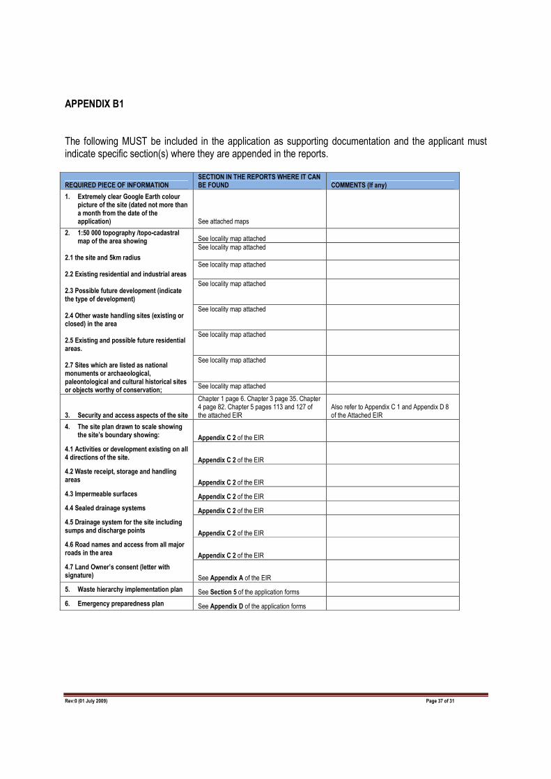
APPENDIX B1
The following MUST be included in the application as supporting documentation and the applicant must indicate specific section(s) where they are appended in the reports.
REQUIRED PIECE OF INFORMATION SECTION IN THE REPORTS WHERE IT CAN BE FOUND COMMENTS (If any)
1. Extremely clear Google Earth colour picture of the site (dated not more than a month from the date of the application) See attached maps
2. 1:50 000 topography /topo-cadastral map of the area showing
2.1 the site and 5km radius 2.2 Existing residential and industrial areas 2.3 Possible future development (indicate the type of development) 2.4 Other waste handling sites (existing or closed) in the area 2.5 Existing and possible future residential areas. 2.7 Sites which are listed as national monuments or archaeological, paleontological and cultural historical sites or objects worthy of conservation;
See locality map attached
See locality map attached
See locality map attached
See locality map attached
See locality map attached
See locality map attached
See locality map attached
See locality map attached
3. Security and access aspects of the site
Chapter 1 page 6. Chapter 3 page 35. Chapter 4 page 82. Chapter 5 pages 113 and 127 of the attached EIR
Also refer to Appendix C 1 and Appendix D 8 of the Attached EIR
4. The site plan drawn to scale showing the site’s boundary showing: Appendix C 2 of the EIR
4.1 Activities or development existing on all 4 directions of the site. Appendix C 2 of the EIR
4.2 Waste receipt, storage and handling areas Appendix C 2 of the EIR
4.3 Impermeable surfaces Appendix C 2 of the EIR
4.4 Sealed drainage systems Appendix C 2 of the EIR
4.5 Drainage system for the site including sumps and discharge points Appendix C 2 of the EIR
4.6 Road names and access from all major roads in the area Appendix C 2 of the EIR
4.7 Land Owner’s consent (letter with signature) See Appendix A of the EIR
5. Waste hierarchy implementation plan See Section 5 of the application forms
6. Emergency preparedness plan See Appendix D of the application forms

Rev:0 (01 July 2009) Page 38 of 31
APPENDIX B2
The following MUST be included in the application documentation for landfill sites and the applicant must indicate specific section(s) where they are appended in the reports.
REQUIRED PIECE OF INFORMATION SECTION IN THE REPORTS WHERE IT CAN BE FOUND COMMENTS (If any)
Design for site roads See Layout plan and Traffic Impact study (Appendix D8 of EIR)
Access and existing roads are highlighted on the layout plan
The 1 in 50 year flood-line of all watercourses See Appendix D5 (Wetland report) No water courses within 1km radius of the site
Laboratory facilities Chapter 3 page 34 of the EIR and Appendix C1 (Engineering input) See attached Layout plan
Design and location of fuel storage areas To be determined during site establishment Not Applicable during the operational phase
Design and location waste quarantine areas Appendix D for layout plan See attached layout plan
Design and location of waste Inspection areas Appendix D for layout plan
See attached layout plan
Site’s drainage system Appendix D for layout plan See attached layout plan
Site’s emergency control system and plan Appendix D for layout plan See attached layout plan
Liner specifications Appendix D for layout plan See attached layout plan
Leak detection system and monitoring Appendix D for layout plan See attached layout plan
Leachate management plan Appendix D for layout plan See attached layout plan
Calculations of leachate generation See Layout plan Liner specifications as per DWAF Minimum Requirements
Leachate collection and treatment Appendix D for layout plan
Gas generation and management Appendix D for layout plan
Air quality monitoring and management See closure and end use plans attached as Appendix E
Co-disposal ratio calculation N/A
Stability monitoring and management N/A
Daily and intermediate cover requirements Appendix D for layout plan
Temporary and permanent capping requirements
Appendix D for layout plan