water affecting activities best practice operating procedure
TRANSCRIPT

Water Affecting Activities Best Practice Operating Procedure EHTM Attachment 6B

Environment and Heritage Technical Manual Attachment 6B
Water Affecting Activities Best Practice Operating Procedure
ii
#17608430
Document Amendment Record
Rev Change Description Date Author Approved
01 Original Version October 2021 MM/DIT Director, Technical Services
Document Management This document is the Property of the Department for Infrastructure and Transport (DIT) and contains information that is confidential to DIT. It must not be copied or reproduced in any way without the written consent of DIT. This is a controlled document and it will be updated and reissued as approved changes are made.
To ensure you have the most up-to-date version of this document refer to:
http://www.DIT.sa.gov.au/standards/environment
The Landscape Boards that have endorsed the use of this BPOP in their region are detailed in Appendix C.

Environment and Heritage Technical Manual Attachment 6B
Water Affecting Activities Best Practice Operating Procedure
iii
#17608430
Contents
1 Overview 1
1.1 Supporting Documentation 1
1.2 Objectives 1
1.3 Applicable Legislation 1
1.4 Best Practice Operating Procedure Endorsement 2
2 The Department’s Procedures and Activities 3
2.1 Work Undertaken by the Department 3
2.2 The Department’s Master Specification 5
3 Relevant Affecting Activities 6
3.1 Water Affecting Activities Covered by this BPOP 6
3.2 Water Affecting Activities Not Covered by this BPOP 6
3.3 Principles for WAAs Undertaken Under this BPOP 7
4 Determining the need for a WAA Permit 8
4.1 Background 8
4.2 WAA Permit Determination Process 8
Appendix A: Landscape Board Boundaries 11
Appendix B: Landscape Board Regions 12
Appendix C: BPOP Endorsement 17
Appendix D: Master Specification WAA Related Inclusions 18
Appendix E: Objectives and Principles for WAAs Requiring Permits 21
Appendix F: WAA Risk Assessment forms 25
Appendix G: WAA Permit Application process 32

Environment and Heritage Technical Manual Attachment 6B
Water Affecting Activities Best Practice Operating Procedure
iv
#17608430
Abbreviations
Term / Acronym Meaning
the Act Landscape South Australia Act 2019
BPOP Best Practice Operating Procedure
DIT or the Department Department for Infrastructure and Transport
LSA Act Landscape South Australia Act 2019
LSA Board Landscape Board
NRM Natural Resources Management
SAMDB South Australian Murray Darling Basin
WAA Water Affecting Activities
WAACP Water Affecting Activities Control Policy
WAP Water Allocation Plans

Environment and Heritage Technical Manual Attachment 6B
Water Affecting Activities Best Practice Operating Procedure
1
#17608430
1 Overview The Water Affecting Activities Best Practice Operating Procedure (BPOP) forms Attachment 6B of the Department’s Environment and Heritage Technical Manual (EHTM). This document applies to a range of Department programs and projects and applies to employees of the Department (direct or contracted) and others operating under the direction of the Department.
This BPOP has been prepared to ensure compliance with Section 104 of the Landscape South Australia Act 2019 (the LSA Act). It outlines the requirements of the LSA Act as it applies to activities undertaken by or on behalf of the Department, and the commitments that the Department and its contractors will undertake to meet the requirements of the Act.
Provisions within regional Water Affecting Activity (WAA) Control Policies and Multi-Activity Permits enable the endorsement of a BPOP by a Landscape Board. Where a BPOP has been approved by a Landscape Board, exclusions from requiring a permit for a defined water affecting activity may apply.
Some procedural resources are available on the Department’s website, whilst other non-Departmental documents can be obtained from the document owner websites.
1.1 Supporting Documentation The following Departmental documentation, supports or forms part of assessments undertaken under this BPOP and are available via the Department’s website:
Protecting Waterways Guideline, which provides processes and methods for minimising impacts on water sources as well as guidance for water quality risk assessments and water quality monitoring for construction sites
Fauna Impact Assessment Guideline, providing fish passage considerations
Guideline for the Assessment and Management of Acid Sulfate Soils
Guideline for the Preparation of a Contractor’s Environmental Management Plan
Guideline for Environmental Audits in Construction
Green Infrastructure Assessment in the Department’s Sustainability Manual, which provides a framework and tools for sustainable decision making during a project lifecycle.
Another relevant resource, not maintained by the Department, is the EPA Stormwater Pollution Prevention Code of Practice for Local, State and Federal Government. As with the Department’s guideline documentation, the purpose of the Code of Practice is to ensure that the Department and its contractors achieve their environmental duty under the Environment Protection Act 1993.
1.2 Objectives The objectives of this BPOP are to:
ensure works undertaken for the planning, construction, operations and maintenance of projects commissioned by the Department comply with relevant water affecting activity provisions of the Landscape South Australia Act 2019; and
ensure that contractors commissioned by the Department comply with the relevant water affecting activity provisions of the Landscape South Australia Act 2019 by undertaking their own assessments and apply for water affecting activity permits when required.
1.3 Applicable Legislation The Department is committed to providing a safe, efficient and sustainable transport infrastructure and comply with legislative requirements. Legislation relevant to this BPOP is the:
Landscape South Australia Act 2019 (the LSA Act)

Environment and Heritage Technical Manual Attachment 6B
Water Affecting Activities Best Practice Operating Procedure
2
#17608430
This Act binds the Crown and therefore the work of the Department. Part 8 of the LSA Act defines provisions for the management and protection of water resources.
Under sections 104 (3) and (4) of the LSA Act, a permit is required for water affecting activities unless the works are approved under another Act, such as the Planning Development and Infrastructure Act 2016, the Environment Protection Act 1993 or the Native Vegetation Act 1991.
Under Sections 100 (4) and 104 (3) a licence is required for the taking of water from a prescribed watercourse, lake or well or to take water from a surface water prescribed area, unless a person is authorised to do so under Section 105 of the Act.
The LSA Act provides the opportunity for each Landscape South Australia Board (Landscape Board) to define activities that require a permit in their Water Affecting Activities Control Policy (WAACP) in accordance with Section 102 of the LSA Act. In the absence of an endorsed Landscape Board WAACP this information may be documented in the Landscape Board’s previous Natural Resources Management Plans, Business and Operational Plans or equivalent.
For a map showing Landscape Board boundaries, refer to Appendix A. For the contact details of each Landscape Board Office and links to their WAACP (or equivalent), refer to Appendix B.
1.4 Best Practice Operating Procedure Endorsement This BPOP is the Department’s procedure for compliance with the LSA Act and can subsequently be endorsed by individual Landscape Boards. For further information confirming endorsement of this BPOP by a particular Landscape Board refer to Appendix C.
In the absence of the BPOP’s endorsement within a Landscape Board area, an application for a Water Affecting Activities Permit (WAAP) is required.

Environment and Heritage Technical Manual Attachment 6B
Water Affecting Activities Best Practice Operating Procedure
3
#17608430
2 The Department’s Procedures and Activities The following sub-section outlines the processes and procedures for the assessment, documentation and approval of water affecting activities during the delivery of a program or project undertaken by, or on behalf of, the Department.
2.1 Work Undertaken by the Department Determining the need for a WAA Permit for works undertaken by the Department and its Contractors in or on a floodplain of a watercourse or lake requires consideration during the pre-delivery, delivery and operation of a project or infrastructure.
Planning and Construction
Infrastructure delivery undertaken by the Department incorporates the planning and construction for both major and minor infrastructure, including but not limited to the following:
construction (including replacement) of road, rail and bridge infrastructure; construction (including replacement) of buildings or dwellings (including schools and
hospitals); installation of signs, fences , railings, safety barriers, gates or safety cameras; installation of traffic control devices and traffic islands; installation of road and infrastructure lighting and Intelligent Transport Systems
infrastructure; installation of rail electrical infrastructure including signals, masts, gantries and substations; construction of rest areas; installation of public amenities or equipment on or adjacent to a road or railway; creation of borrow pits, campsites, dams and maintenance turnaround points; installation of culverts (including extensions); shoulder sealing and extensions to shoulders (sealed or unsealed); establishment of safe sight lines and sight triangles at road intersections and rail crossings;
and landscaping, revegetation or beautification works.
Operations and Maintenance
The Commissioner of Highways responsibilities for road maintenance are outlined in the Operational Instruction 20.1: Care, Control & Management of Roads (Highways) by the Commissioner of Highways.
Maintenance activities include the following:
road shoulders; established road/rail clearance envelopes, clear zones and sight lines; culverts, drains (including headwalls and open drains) and verges; cut rock faces; bridge abutments; fences, railings, barriers or gates; traffic control devices, safety cameras, traffic islands; infrastructure lighting, Intelligent Transport Systems infrastructure, and departmental
signs; rail and light rail electrical infrastructure including signals, masts, gantries and
substations; rail and light rail track maintenance (re-sleepering, re-ballasting, tamping, grinding etc.);

Environment and Heritage Technical Manual Attachment 6B
Water Affecting Activities Best Practice Operating Procedure
4
#17608430
rail and light rail corridor drain clearing and cleaning; rail stations; public parking bays or roadside rest areas including amenities or equipment; stacking sites (for storage of pavement/shoulder material and materials/equipment); and
borrow pits, campsites, bores, dams and maintenance turnaround points.

Environment and Heritage Technical Manual Attachment 6B
Water Affecting Activities Best Practice Operating Procedure
5
#17608430
2.2 The Department’s Master Specification The Department’s Master Specification sets out the requirements to achieve the quality and/or performance outcomes expected in the finished product for construction projects and professional services. It enables the Department to communicate standard requirements across industry to supply materials, plan, design, construct and maintain its road, rail and marine infrastructure assets.
Each specification consists of a technical specification, with reference to standards and legislative compliance requirements with supplementing references as required.
The five categories of Project Controls, Roads, Transport Planning, Public Realm and Maintenance are most relevant to this BPOP.
The Master Specification is the mechanism that ensures water disciplines, including watercourse and stormwater quality, water affecting activities and water sensitive urban design (WSUD) are an integral part of the planning, design, construction and maintenance of infrastructure overseen by the Department.
This BPOP should be read in conjunction with the following relevant Master Specification categories and parts identified in Table 2.1 below. For further information summarising the water affecting activity related inclusions refer to Appendix D.
Table 2.1 Relevant Master Specification categories and parts that may apply to projects
Master Specification Category
Master Specification
Part
Project Controls
PC-ENV1 Environmental Management
PC-ENV2 Environmental Protection Requirements
PC-ENV3 Environmental Design
PC-SC1 Site Contamination
PC–SI2 Site Investigation
PC-ST1 Sustainability in Design
PC-EDM3 Independent Design Certifier
PC-EDM4 Construction Verification
Roads RD-DK-01 Road Drainage Design
RD-DK-02 Hydrology
Transport Planning
PC-PL1 Framework for Planning Studies
PC-PL2 Planning Investigations
PC-PL3 Concept Design Development
PC-PL4 Constructability Assessment
Public Realm
PR-LS-D1 Landscaping Design PR-LS-C5 Erosion Control Matting
PR-LS-C10 Installation of Water Sensitive Urban Design
Maintenance
M7 Environmental Management M8 Environmental Protection
M10 Maintenance – sealed roads
M11 Maintenance – unsealed roads

Environment and Heritage Technical Manual Attachment 6B
Water Affecting Activities Best Practice Operating Procedure
6
#17608430
3 Relevant Affecting Activities A Landscape Board’s WAA Control Policy sets out the WAAP requirements which apply in its region (which in some cases may be different in different parts of the landscape management region), where these are not already regulated by a relevant Water Allocation Plan (WAP). It may direct the reader to the relevant sections of a WAP for some particular WAAs, but does not overlap with the principles in a WAP.
The WAA Control Policy sets out the matters to be considered by the relevant authority when granting a WAA Permit. A WAA Control Policy may detail the WAAs which could be excluded from requiring a permit if undertaken in accordance with an agreed BPOP.
3.1 Water Affecting Activities Covered by this BPOP The LSA Act outlines provisions for the control of WAA. The relevant activities of Section 104 (4) of the LSA Act that apply to the selection matrix to determine low risk activities as described in Section 4 are:
Section 104 (4)
(b) the erection, construction or placement of any building or structure in a watercourse or lake or on the floodplain of a watercourse;
(d) depositing or placing an object or solid material in a watercourse or lake;
(e) obstructing a watercourse or lake in any other manner;
(f) depositing or placing an object or solid material on the floodplain of a watercourse or near the bank or shore of a lake to control flooding from the watercourse or lake;
(g) destroying vegetation growing in a watercourse or lake or growing on the floodplain of a watercourse;
(h) excavating or removing rock, sand or soil from—
(i) a watercourse or lake or the floodplain of a watercourse; or
(ii) an area near to the banks of a lake so as to damage, or create the likelihood of damage to, the banks of the lake;
A person must not undertake any of the above WAA unless in accordance with the relevant regional WAA Control Policy or Water Allocation Plan (WAP). Typically, all WAA to be undertaken will be assessed on merit by the Landscape Board, with regard to objectives and principles that are published in the WAA Control Policy. The use of a BPOP is accepted by the Landscape Board as the mechanism to approve WAA permits for low risk activities, providing they are undertaken in accordance with the BPOP.
For further information confirming endorsement of this BPOP by a particular Landscape Board refer to Appendix C. For other Landscape Boards not listed in Appendix C, refer to each Landscape Board’s website for water affecting activity processes.
Appendix E presents the objectives and principles for undertaking WAAs without a permit under this BPOP (i.e. lower risk WAAs)
3.2 Water Affecting Activities Not Covered by this BPOP Some WAA are not covered by this procedure including those identified as high risk using the selection matrix in Section 4 and any of the following activities:
Section 104 (4)
(a) the erection, construction, modification, enlargement or removal of a dam, wall or other structure that will collect or divert, or collects or diverts, water flowing in a watercourse that is not in the Mount Lofty Ranges Watershed and that is not

Environment and Heritage Technical Manual Attachment 6B
Water Affecting Activities Best Practice Operating Procedure
7
#17608430
prescribed or flowing over any other land that is not in a surface water prescribed area or in the Mount Lofty Ranges Watershed;
Section 104 (3)
(d) the erection, construction, modification, enlargement or removal of a dam, wall or other structure that will collect or divert, or collects or diverts—
(i) water flowing in a prescribed watercourse; or
(ii) water flowing in a watercourse in the Mount Lofty Ranges Watershed that is not prescribed; or
(iii) surface water flowing over land in a surface water prescribed area or in the Mount Lofty Ranges Watershed;
These WAAs will require individual applications and assessment based on merit. Note that construction of a wetland is likely considered the construction of a water body (dam).
Additionally, other WAA defined in Section 104(1-3) in relation to water taking and groundwater wells are not captured in this BPOP. Refer to the relevant Landscape Boards website for further details.
3.3 Principles for WAAs Undertaken Under this BPOP The following overarching principles apply for undertaking activities under this BPOP in the absence of a permit (i.e. lower risk activities):
Activities should not compromise the use or quality of water resources, or the capacity for natural systems to restore or maintain water quality.
Activities should not take place where they are likely to adversely impact on the migration of biota.
Natural creek and watercourse systems should be retained.
The design, construction and management of structures and activities must not result in watercourse erosion.
Activities should be designed and located so as not to alter the geomorphology of a watercourse or lake.
Activities should not contribute to dryland salinity or rising water tables.
Activities should not compromise the integrity of authorised scientific data collection and monitoring facilities related to the assessment and management of water resources.
Activities should not:
o be located in ecologically sensitive areas
o cause or exacerbate unnatural waterlogging, or increase groundwater induced salinity
o affect water-dependent ecosystems, or environmental water requirements for underground water, watercourse, wetlands or floodplains
o cause or increase the risk of flooding, upstream or down
o cause or increase erosion, or affect bed and bank stability, or
o detrimentally impact on ecological diversity and habitats.
In considering the above overarching principles, it should be noted that works undertaken are often constrained by the existing location of infrastructure.
When a permit is required to undertake a WAA, the objectives and principles as detailed in Appendix E will be applicable.

8
#17608430
4 Determining the need for a WAA Permit
4.1 Background Under this BPOP the following permit requirements will apply to activities undertaken by the Department’s staff and contractors.
For proposed Water Affecting Activities (WAA) to be undertaken in a Landscape Board region, this BPOP will include all minor and low risk activities undertaken by the Department including maintenance activities and new works.
Minor and low risk maintenance activities, as defined as Routine Maintenance in the Master Specification Part M10 and M11 do not require a permit. Specific Maintenance, as defined in Master Specification Parts M10 and M11, which may include replacement of broken, damaged, cracked or spalled drainage elements will require the ‘Water Affecting Activity Permit Determination Process’ (Refer to Section 4.2 below) to be applied.
The Department and/or its contractors will apply for a WAA Permit for projects with potential for high impact, where a Development Approval under the Planning, Development and Infrastructure Act 2016, a relevant authorisation under the Environment Protection Act 1993, or a relevant approval under the Native Vegetation Act 1993 is not required.
The ‘Water Affecting Activity Permit Determination Process’ will be used to determine whether projects and activities require a separate WAA Permit. Where an activity has the potential to have a high impact, i.e. a score 13 or greater in accordance with the procedure, a separate WAA Permit must be obtained.
Works in the Alinytjara Wilurara and SA Arid Lands Board Regions are considered differently from the other Landscape Board regions due to differences in rainfall amount and timing (rainfall is more likely in summer months). In these regions the risks differ as the watercourses are less disturbed and there is a higher risk if works occur when water is present. These differences are reflected in the first four parameters of the WAA Risk Assessment form developed specifically for these two Landscape Board regions.
4.2 WAA Permit Determination Process To determine whether a project or activity requires a WAA Permit, follow Steps 1-6 below, or refer to Figure 4.1 below.
Step 1:
Determine if the project or activity is within a watercourse, lake or floodplain.
Step 2:
Determine if the activity is covered by the BPOP and if the BPOP has been endorsed in the Landscape Region where the WAA will take place.
Step 3a:
Determine whether an activity or project will require a WAA Permit by undertaking a WAA Risk Assessment.
Undertake the WAA Risk Assessment using either the:
WAA Risk Assessment form for all Landscape Board Regions except for those with standalone risk assessment forms;
WAA Risk Assessment form for the Landscape Board Regions of Alinytjara Wilurara and SA Arid Lands.

9
#17608430
WAA Risk Assessment form for the Landscape Board Regions of Eyre Peninsula and Riverland and Murraylands.
Step 3b:
Where this BPOP has not been endorsed in a Landscape Region, determine if the works incorporate an activity that is excluded from requiring a permit under the relevant WAACP or, in the absence of a WAACP, the Landscape Board’s previous NRM Plan, Business and operational plan or equivalent exclusion.
To identify the correct form, confirm the Landscape Board region for the project area using NatureMaps, and activate the administrative boundaries layer to enable activation of the landscape management regions. ‘Sub’ regional district management areas will be defined within each Landscape Board’s WAA Control Policy or in previous Natural Resources Management Plans, Business and Operational Plans or equivalent.
Editable copies of the WAA Risk Assessment forms can be accessed from the Department’s website. For examples of the forms, refer to Appendix F.
A score will be derived from the risk assessment, which will determine whether or not a WAA Permit will be required.
If a score of less than 13 (i.e. 12 or less) is derived a WAA Permit will not be required, however works must continue to be undertaken in accordance with the Department’s Master Specification requirements.
If a score of 13 or greater is derived, a WAA Permit application in accordance with each Landscape Board requirements needs to be submitted.
Each Landscape Board has a separate Application form for WAA Permits, and defined application processes apply. Refer to the relevant Landscape Board’s water affecting activities web page on each Landscape Board website for more details. An indicative summary of the process for the Department’s staff and its contractors is documented in Appendix G.
Notes regarding the WAA Permit Determination Process implementation:
The assessment must be undertaken by staff with appropriate knowledge and experience.
The WAA Risk Assessments and WAA Permit, where required, must form part of the Environment and Heritage Impact Assessment (EHIA) documentation.
All WAA Risk Assessments completed under a Best Practice Operating Procedure (BPOP) require records to be kept for annual reporting by Department staff. A copy of all risk assessments must be submitted to the Department prior to the commencement of works in accordance with Master Specification Part PC-ENV1 Section 3 Environmental Authorisations.
Separately, Landscape Boards may also require WAA Risk Assessments, along with supporting site and project information to be submitted prior to works commencing. For these requirements, refer to Appendix C of this BPOP.

10
#17608430
Figure 4.1: WAA Permit determination flowchart

11
#17608430
Appendix A: Landscape Board Boundaries
Refer to links at the Landscape South Australia website for each Landscape Board region.

12
#17608430
Appendix B: Landscape Board Regions
Refer to links at the Landscape South Australia website for each Landscape Board region.
Alinytjara Wilurara
Level 9, 81-95 Waymouth Street
ADELAIDE SA
Phone: (08) 8463 4843 or 0408 295 039
Contact the Landscape Board’s Water Resource Officer at: [email protected]
The Minister for Environment and Water has approved the Alinytjara Wilurara (AW) Landscape Board Landscape Plan 2021-2026.
The Alinytjara Wilurara Landscape Board’s current WAAs can be found in Appendix 1 of the AW Landscape Board Annual Business Plan 2021-22.
Note: There is no private land in the AW Landscape Region. The primary land tenure is formally recognised Aboriginal Lands, National Parks, Wildlife Reserves and Wilderness Protection Areas. The informed consent of the land holding authority is required prior to AW Landscape Board decision on permit applications and will influence the time frames for permit approval. As the processing and granting of a permit can take some time, applications for a permit must be made some months in advance of undertaking the water affecting activity.
Eyre Peninsula
Port Lincoln Office
86 Tasman Terrace,
PORT LINCOLN, SA 5606
Phone: (08) 8688 3111
Contact the Landscape Board’s Water Resource Officer at: [email protected]
The Landscape Board’s current WAAs can be found in the existing Strategic Plan on the Landscape Board’s website in Chapter 7, Policy Framework. These were developed under the previous NRM Act and have been endorsed by the Landscape Board under the LSA Act transitional arrangements.
Landscape Board Staff are in the process of drafting a new Regional Landscape Plan and as part of the package, including a new Water Affecting Activity Control Policy (WAACP). It is anticipated the WAACP will be formally endorsed mid-2021.
Once finalised, it is anticipated the WAACP can be sourced on the Landscape Board’s website.
Water Allocation Plans (WAP) exist for the following prescribed wells areas within the Eyre Peninsula Board region: the Musgrave and Southern Basins Prescribed Wells Area.
For information about Water Allocation Plans in the Eyre Peninsula Board region, source from the Water Allocation Plan page on the Landscape Board’s website.

13
#17608430
Green Adelaide
81–95 Waymouth Street,
ADELAIDE SA 5000
Phone: (08) 8463 3733
Contact the Landscape Board’s Water Resource Officer at: [email protected]
The Landscape Board’s WAAs are currently being confirmed following the establishment of the Green Adelaide Board region as part of the transition from the former NRM Act to the current LSA Act.
A Water Affecting Activity Control Policy (WAACP) has been prepared for this region. The WAACP can be sourced on the Board's website.
Permit exemptions exist for some water affecting activities within this Board region. For example, you will not have to apply for a water affecting activity permit under section 104(4)(g) of the LSA Act when removing the plant species and the removal method defined in Table 1 of the ‘Current recommended practice: Removal of vegetation from a watercourse, lake or floodplain’.
Once adopted, a Water Allocation Plan (WAP) will exist for the Adelaide Plains prescribed water resource area within the Green Adelaide Board region.
For information about WAPs in the Green Adelaide Board region, source from the WAP page on the Landscape Board's website.
Hills and Fleurieu
Mt Barker Upper level, corner Mann & Walker streets,
MOUNT BARKER SA 5251
Phone: (08) 8391 7500
Contact the Landscape Board’s Water Resource Officer at: [email protected]
A Water Affecting Activity Control Policy (WAACP) has been prepared for this region. The WAACP can be sourced on the Landscape Boards website.
Permit exemptions exist for some water affecting activities within this Landscape Board region. For example, you will not have to apply for a water affecting activity permit under section 104(4)(g) of the LSA Act when removing the plant species and the removal method defined in Table 1 of the ‘Current recommended practice: Removal of vegetation from a watercourse, lake or floodplain’.
Water Allocation Plans (WAP) exist or are being developed for the following prescribed water resource areas within the Hills and Fleurieu Board region:
McLaren Vale; Western Mt Lofty Ranges.
For information about WAPs in the Hills and Fleurieu Board region, refer to the WAP page on the Landscape Board's website.

14
#17608430
Kangaroo Island
C/- Natural Resources Centre – Kingscote
37 Dauncey Street,
KINGSCOTE, SA 5223
Phone: (08) 8553 4444
Contact the Landscape Board’s Water Resource Officer at: [email protected]
The Bo Landscape ard’s current WAAs can be found in the existing WAA Control Policy . The policy was developed under the previous NRM Act and have been endorsed by the Landscape Board under the LSA Act transitional arrangements.
The 2017 Water Affecting Activity Policy that forms part of the Kangaroo Island Natural Resources Management Plan in operation on June 30 2019, under the repealed NRM Act 2004, was adopted by the Kangaroo Island Landscape Board under schedule 5 of the Landscape SA Act 2019 and will be taken to be the Kangaroo Island Water Affecting Activity Control Policy under the LSA Act 2019, until is it replaced by a new Kangaroo Island Water Affecting Activity Control Policy. Parts of the 2017 Water Affecting Activity Policy that has effect for the purposes of water affecting activities under section 127 of the repealed NRM Act 2004 will continue to have effect under schedule 5 of the LSA Act 2019 as water affecting activities under section 104 of the LSA Act 2019.
Landscape Board Staff are in the process of drafting a new Water Affecting Activity Control Policy (WAACP). It is anticipated the WAACP will not vary significantly from the existing plan and will be finalised and formally endorsed during 2021.
Once finalised, it is anticipated the WAACP can be sourced on the Landscape Board's website.
Limestone Coast
11 Helen Street,
MOUNT GAMBIER SA 5290
Phone: (08) 8735 1177
Contact the Landscape Board’s Water Resource Officer at: [email protected]
Landscape Board Staff are in the process of finalising a new Water Affecting Activity Control Policy (WAACP) that will include a summary of the Landscape Boards WAA. The WAACP will introduce the ability for some WAA to be undertaken without a permit where a 'current accepted practice' has been developed and adopted.
Once finalised, it is anticipated the WAACP can be sourced on the Landscape Board's website.
Water Allocation Plans (WAP) exist for the following prescribed water resources areas / prescribed watercourses / prescribed wells areas within the Limestone Coast Board region:
Padthaway; Tatiara; Tintinara – Coonalpyn; Lower Limestone Coast; Morambro Creek.
For information about WAPs in the Limestone Coast Board region, refer to the WAP page on the Landscape Board's website.

15
#17608430
Murraylands and Riverland
110A Mannum Road,
MURRAY BRIDGE, SA 5253
Phone: (08) 8532 9100
Contact the Landscape Board’s Water Resource Officer at: [email protected]
The Landscape Board’s current WAAs can be found in the South Australian Murray Darling Basin (SAMDB) Natural Resources Management Plan developed under the previous NRM Act and have been endorsed by the Landscape Board under the LSA Act transitional arrangements.
Landscape Board Staff are in the process of drafting a Water Affecting Activity Control Policy (WAACP). It is anticipated the WAACP will be formally in the first half of 2021.
Once finalised, it is anticipated the WAACP can be sourced from the Board's website.
A summary from the SAMDB Natural Resources Management Plan is provided below:
Water Allocation Plans (WAP) exist for the following prescribed water resources areas / prescribed watercourse / prescribed wells areas within the Murraylands and Riverland Board region:
Eastern Mount Lofty Ranges; Mallee; Marne Saunders; Noora; Peake, Roby and Sherlock; River Murray.
For information about WAPs in the Murraylands and Riverland Board region, refer to the WAP page on the Landscape Board's website.
Northern and Yorke
155 Main North Road
CLARE SA 5453
Phone: (08) 8841 3400
Contact the Landscape Board’s Water Resource Officer at: [email protected]
A Water Affecting Activity Control Policy (WAACP) has been prepared for this region. The WAACP can be sourced on the Landscape Board's website.
Also refer to the Landscape Board’s Guide to applying for a WAA permit .
An excerpt from the Landscape Board’s WAACP is provided below:
Water Allocation Plans (WAP) exist or are being developed for the following prescribed water resources areas within the Northern and Yorke Landscape Board region:
Clare Valley; Baroota; Barossa.
For information about WAPs in the Northern and Yorke Board region, source from the WAP page on the Landscape Board's website.
16
#17608430
South Australian Arid Lands
Railway Station Building, Stirling Road (PO BOX 297)
Port Augusta SA 5700
Tel: (08) 8648 5307 Fax: (08) 8648 5301
Contact the Landscape Board’s Water Resource Officer at: [email protected]
A Water Affecting Activity Control Policy (WAACP) has been prepared for this region. The WAACP can be sourced on the Landscape Board's website.
Water Allocation Plans (WAP) exists for the following prescribed wells area within the SA Arid Lands Landscape Board region: The Far North.
For information about WAPs in the SA Arid Lands Board region, refer to the WAP page on the Landscape Board's website.
Department for Environment and Water (DEW), Water Licences and Permits
GPO Box 1047
ADELAIDE SA 5001
Phone: (08) 8463 6876
Email: [email protected]
Water licences and permits:
http://www.environment.sa.gov.au/licences-and-permits/water-licence-and-permit-forms

17
#17608430
Appendix C: BPOP Endorsement
As documented in Section 1.3, a function of the Department’s BPOP is to enable Landscape Boards established in accordance with the LSA Act to endorse the BPOP for water affecting activities within a Landscape Board region.
Further details regarding each endorsed BPOP is documented below.
For other Landscape Boards not listed here, refer to each Landscape Board’s website for water affecting activity processes.
Alinytjara Wilurara Landscape Board
The Alinytjara Wilurara (AW) Landscape Board has endorsed the Department’s BPOP on an ongoing basis from 7 October 2021.
At the end of each financial year, the Department is to provide a report to the AW Landscape Board detailing the Risk Assessments that have been undertaken and the permits sought in that period. Copies of the Risk Assessments are to be provided to the AW Landscape Board as part of the annual reporting. The AW Landscape Board may undertake an audit of the Department’s activities to ensure compliance.
The following Landscape Boards are yet to provide their endorsement of this BPOP:
Northern and Yorke
Limestone Coast
Green Adelaide
Murraylands and Riverland
Eyre Peninsula
South Australian Arid Lands
Kangaroo Island
Hills and Fleurieu

18
#17608430
Appendix D: Master Specification WAA Related Inclusions
Master Specification
Category
Master Specification
Part WAA Related Inclusions
Project Controls
PC-ENV1 Environmental Management
Contractors General Obligations; Environmental and planning approvals, permits
and authorisations; Environmental objectives for project; Contractor’s Environmental Management Plan; Prevent pollution of surface, ground and marine
water requirement; Inspection and auditing during construction; Non-compliance rectification requirements
PC-ENV2 Environmental Protection Requirements
Construction methods and temporary works
avoiding or minimising nuisance and harm to wetlands and waterways.
design and establishment of temporary creek crossings;
Vegetation clearing and pruning not remove, disturb or damage any
vegetation, including aquatic vegetation, unless otherwise approved;
High Value Vegetation, including in and on the margins of waterways;
Protecting Waterways requirements Soil, Erosion and Drainage Management; Water Quality Monitoring; and Use of construction water.
PC-ENV3 Environmental Design
Identifying environmentally sensitive areas
(waterways). Water Quality Risk Assessment in accordance
with RD-DK-01; Considerations for fish passage
PC-ST1 Sustainability in Design and ST2 Sustainability in Construction
Protect and enhance water quality; Identifying opportunities to reduce water use
during construction.
PC-EDM4 Construction Verification
Assessment and surveillance verification of
works around waterways and water bodies, including high value vegetation.

19
#17608430
Master Specification
Category
Master Specification
Part WAA Related Inclusions
Roads
RD-DK-01 Road Drainage Design
ARI design standards; Climate Change; Water Sensitive Urban Design; Erosion and Sediment; Stormwater Treatment Infrastructure; Water Quality Risk Assessment.
RD- DK-02 Hydrology
Climate Change; Sea Level Rise; Water Catchment Assessment; Hydrological modelling.
PC-PL2 Planning Investigations
Climate Change; Environment and Heritage Impact Assessment; Stormwater and Hydrology.
Public Realm
PR-LS-C5 Erosion Control Matting
SEDMP control measure.
Maintenance
M7 Environmental Management
Contractors General Obligations; Environmental and planning approvals, permits
and authorisations; Environmental objectives for project; Contractor’s Environmental Management Plan; Prevent pollution of surface, ground and marine
water requirement; Inspection and auditing during construction; Non-compliance rectification requirements.
M8 Environmental Protection
Construction methods and temporary works
avoiding or minimising nuisance and harm to wetlands and waterways.
design and establishment of temporary creek crossings;
Vegetation clearing and pruning not remove, disturb or damage any
vegetation, including aquatic vegetation, unless otherwise approved;
High Value Vegetation, including in and on the margins of waterways;
Protecting Waterways requirements Soil, Erosion and Drainage Management; Water Quality Monitoring; and Use of construction water.

20
#17608430
Master Specification
Category
Master Specification
Part WAA Related Inclusions
M10 Maintenance – Sealed Roads
Working within watercourses and/or wetlands hold point
Clear Drainage Elements
Clear Open Lined Drains
Clear Subsoil Drains
Clear Drainage Retention and Detention Basins
Scour repair
M11 Maintenance – Unsealed Roads
Turkey nest dam requirements Use of bores Clearing of drains Working within watercourses and/or wetlands
hold point
Supporting resources to deliver the requirements and inclusions above are available on the Department’s website, whilst other non-Departmental documents can be obtained from the document owner websites.
For a selection of those relevant resources, refer to Appendix G.
21
#17608430
Appendix E: Objectives and Principles for WAAs Requiring Permits
When a permit is required to undertake a WAA, the objectives and principles of the permit as detailed in the following sub-sections should be expected.
Structures in Watercourses: Section 104(4)(b) The objectives and principles that follow apply specifically to an activities under section 104(5)(b), the erection, construction or placement of any building, or structure, in a watercourse or lake, or on the floodplain of a watercourse.
Objectives
1. Minimise the potential for erosion and the restriction of surface water flows.
2. Protect the ecology of a watercourse, or lake, or the floodplain of a watercourse.
Principles
1. Construction and placement of structures, including roads, in a watercourse, a floodplain of a watercourse, a lake, a wetland, or an area subject to inundation:
a. shall be designed to minimise the risk of erosion resulting from the construction and location of the structure
b. must not adversely affect the provision of environmental water requirements of those areas (for example, by impeding flows)
c. must not adversely affect the migration of aquatic biota
d. must not alter the hydrology of a stream in such a way as to adversely impact on the ecology
e. must not result in flooding, either upstream or downstream
f. must not be constructed where it, or any debris collected by it, would increase the risk of damage to property or the risk to safety of persons.
2. Structures that impede the flow of water, including but not limited to weirs, must be designed to enable flows at or below the threshold flow rate, excluding structures for the specific purpose of measuring stream flow for scientific purposes.
Draining or discharge of water into a watercourse or lake: section 104(5)(c) The objectives and principles that follow apply specifically to an activities under section 104(5)(c) draining or discharging water directly, or indirectly, into a watercourse or lake.
In addition to the objectives and principles outlined in this section, the requirements of the Environment (Water Quality) Policy 2015 (or any subsequent or related document) prepared under the Environment Protection Act 1993 (SA) should be considered.
Objectives
1. Protect ecosystems dependent on the receiving water resources.
2. Sustain the existing uses of the receiving water resources.
Principles
1. Drained and discharged water must be of a suitable quality to:
a. sustain the existing uses of the receiving waters
b. protect ecosystems that are dependent on the receiving waters.
2. Draining or discharging water must be undertaken in a manner that ensures:

22
#17608430
a. contaminants in drainage or discharge water are contained and managed on site to minimise the conveyance of contaminants into watercourses, lakes, or underground water resources
b. the quality of water drained, or discharged, into a watercourse, or lake, is of the same quality or better than that of the receiving water environment.
3. The discharge or drainage of water into a watercourse must be at a rate and in a location such that:
a. the geomorphology of the watercourse is protected
b. the flow capacity of the watercourse is considered
c. there is no increase in the risk of flooding downstream
d. the migration of aquatic biota is not adversely affected.
4. Drainage or discharge of water into a watercourse, or lake, shall be undertaken only where protective measures have been provided to minimise erosion or degradation in the quality of the receiving water.
5. Watercourses shall be retained in their natural state, to promote natural filtering and pollutant removal processes.
Depositing objects in a watercourse: sections 104(4)(d), 104(4)(e) and 104(4)(f)
The objectives and principles that follow apply specifically to an activities under:
section 104(4)(d) depositing or placing an object or solid material in a watercourse, or lake
section 104(4)(e) obstructing a watercourse, or lake, in any other manner
section 104(4)(f) depositing or placing an object or solid material on the floodplain of a watercourse, or near the bank or shore of a lake, to control flooding from the watercourse, or lake.
Objectives
1. Protect watercourses and lakes against:
a. destruction of bed and banks
b. water pollution
c. erosion
d. habitat destruction.
2. Ensure watercourses or lakes, are free of obstructions that may:
a. impede natural stream flow, or
b. cause unnecessary flooding.
Principles
1. An object, or solid material, shall be deposited or placed in a watercourse, or lake, only where it includes:
a. the construction of an erosion control structure, for example a rock chute or rip rap
b. a device or structure used to extract or regulate water flowing in a watercourse, for example diversion weirs
2. Any object or solid material used in the control or prevention of watercourse erosion shall not cause:
a. increased erosion upstream or downstream
b. detrimental impacts.

23
#17608430
3. The depositing or placing of an object, or solid material, in a watercourse, or lake, shall not adversely affect:
a. Water-dependent ecosystems
b. the migration of aquatic biota, or
c. the natural flow regime.
4. Obstructing a watercourse or lake shall not cause erosion.
5. Depositing or placing an object, or solid material, on the floodplain of a watercourse, or near the bank or shore of a lake, to control flooding from the watercourse, or lake, shall not:
a. adversely impact upon the natural flow of a watercourse
b. increase the risk of flooding, upstream or downstream, or
c. cause or increase watercourse erosion.
6. Depositing or placing an object, or solid material, on the floodplain of a watercourse, or near the bank or shore of a lake, to control flooding from the watercourse, or lake, should:
a. provide for the needs of ecosystem processes (including the migration of aquatic biota)
b. minimise the impact or risk of flooding on human communities.
Note: For the purpose of these principles, an ‘object’ can include vegetation, such as fallen trees and other plant debris.
Destroying vegetation or excavating in a watercourse: sections 104(4)(g) and 104(4) (h)
These sections do not apply where the clearance of vegetation requires approval under the Native Vegetation Act 1991.
The objectives and principles that follow apply specifically to an activity under:
section 104(4)(g), destroying vegetation growing in a watercourse, or lake, or growing on the floodplain of a watercourse
section 104(4)(h), excavating or removing rock, sand or soil from:
o a watercourse, or lake, or the floodplain of a watercourse, or
o an area near to the banks of a lake, so as to damage, or create the likelihood of damage to, the banks of the lake.
Objective
Ensure that watercourses, lakes and floodplains are protected against adverse impacts arising from the destruction of vegetation or the excavation and removal of rock, sand and soil.
Principles
1. Vegetation shall be destroyed only where it is for the protection of existing development or infrastructure, or rehabilitation of a watercourse, and does not result in any of the following:
a. increased erosion
b. increased flooding
c. bed and bank instability
d. downstream sedimentation
e. decline in water quality
f. alteration to the natural flow regime of a watercourse
g. destruction of significant habitat for wildlife.

24
#17608430
2. The excavation and removal of rock, sand or soil must not adversely impact on:
a. the ecology of a watercourse, lake or floodplain
b. migration of aquatic biota.
3. The excavation and removal of rock, sand or soil must not result in:
a. increased erosion
b. increased flooding
c. bed and bank instability
d. downstream sedimentation
e. loss of riparian vegetation
f. decline in water quality
g. alteration to the natural flow regime of a watercourse.

25
#17608430
Appendix F: WAA Risk Assessment forms Editable copies of the WAA Risk Assessment forms can be accessed from the Department’s website.

26
#17608430

27
#17608430

28
#17608430

29
#17608430

30
#17608430

31
#17608430
32
#17608430
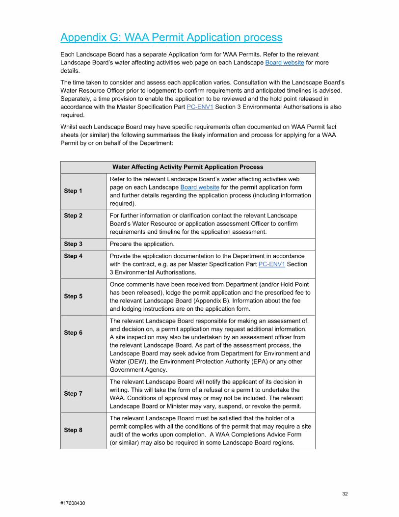
Appendix G: WAA Permit Application process
Each Landscape Board has a separate Application form for WAA Permits. Refer to the relevant Landscape Board’s water affecting activities web page on each Landscape Board website for more details.
The time taken to consider and assess each application varies. Consultation with the Landscape Board’s Water Resource Officer prior to lodgement to confirm requirements and anticipated timelines is advised. Separately, a time provision to enable the application to be reviewed and the hold point released in accordance with the Master Specification Part PC-ENV1 Section 3 Environmental Authorisations is also required.
Whilst each Landscape Board may have specific requirements often documented on WAA Permit fact sheets (or similar) the following summarises the likely information and process for applying for a WAA Permit by or on behalf of the Department:
Water Affecting Activity Permit Application Process
Step 1
Refer to the relevant Landscape Board’s water affecting activities web page on each Landscape Board website for the permit application form and further details regarding the application process (including information required).
Step 2 For further information or clarification contact the relevant Landscape Board’s Water Resource or application assessment Officer to confirm requirements and timeline for the application assessment.
Step 3 Prepare the application.
Step 4 Provide the application documentation to the Department in accordance with the contract, e.g. as per Master Specification Part PC-ENV1 Section 3 Environmental Authorisations.
Step 5
Once comments have been received from Department (and/or Hold Point has been released), lodge the permit application and the prescribed fee to the relevant Landscape Board (Appendix B). Information about the fee and lodging instructions are on the application form.
Step 6
The relevant Landscape Board responsible for making an assessment of, and decision on, a permit application may request additional information. A site inspection may also be undertaken by an assessment officer from the relevant Landscape Board. As part of the assessment process, the Landscape Board may seek advice from Department for Environment and Water (DEW), the Environment Protection Authority (EPA) or any other Government Agency.
Step 7
The relevant Landscape Board will notify the applicant of its decision in writing. This will take the form of a refusal or a permit to undertake the WAA. Conditions of approval may or may not be included. The relevant Landscape Board or Minister may vary, suspend, or revoke the permit.
Step 8
The relevant Landscape Board must be satisfied that the holder of a permit complies with all the conditions of the permit that may require a site audit of the works upon completion. A WAA Completions Advice Form (or similar) may also be required in some Landscape Board regions.