water harvesting from roads in tigray, northern ethiopia...
TRANSCRIPT

1
Water harvesting from roads in Tigray, Northern Ethiopia:
Practices, Opportunities and Design Considerations
By:
Kifle Woldearegay1, Diego Garcia-Landarte Puertas2, Frank Van
Steenbergen2, Martin Van Beusekom2, Marta Agujetas2
(1Mekelle University, Ethiopia; 2MetaMeta, The Netherlands)
May 2014
2
1. Introduction
Ethiopia in general and the arid to semi-arid environments of the country in particular has
been associated with food insecurity which in turn is related to water insecurity. One of the
un-recognized potentials which need due consideration in Ethiopia and in many Sub-Saharan
Africa is water harvesting from roads.
A well planned and implemented road development has a number of benefits among which is
fueling growth process through different activities of the development endeavors of a nation
including: creating market access opportunities for agricultural products, access to services
(health, schools, etc) and contribute to the socio-economic development of an area.
Understanding the importance of the sector, Ethiopia has been involved in massive road
construction in the last two decades. The country plans to undertake further road development
in order to connect local administration regions (Tabias/Kebele).
In the case of Tigray region, for example, Until the year 2015, the Tigray region, for example
plans to construct a total of 5177Km new roads in which 1004km from Regional budget and
4173km from Federal budget. Moreover, the region plans to construct 3086 km all weather
roads to improve the existing 230 kebelle network to 712 in 2014/15. This is expected to
decrease the existing distances to reach the all weather roads from its 6.223 km to 2.36 by the
end of 2014/15.
Despite the benefits created from road development, road construction can create a number of
problems especially to communities close to the roads. Some of the major problems include:
flooding, water logging, erosion and the development of gullys, and other environmental
problems.
This study, which is part of the UPGro Catalyst research grant, has tried to assess the effects
of water from roads, and the status as well as opportunities for water harvesting from roads in
Tigray, Northern Ethiopia. The site selected in this study is the “Freweign-Hawzien-Abreha
Weatsbeha-Wukro route” in Tigray, Northern Ethiopia.
2. Objectives of the study
The main objectives of the study were to:

3
§ Undertake a detailed inventory of the effects of water from roads in the study area.
§ Evaluate the geohydrological and geotechnical condition of the area in relation to
suitability for water harvesting.
§ Assess the practice of water harvesting from roads in Tigray, with more focus to the
practice in the Freweign-Hawzien-Abreha Weatsbeha-Wukro route.
§ Review the current approach and institutional arrangement in relation to the design
and construction of roads, water resources development, and natural resources
management.
§ Recommend approaches for the design and construction of multi-functional roads that
integrate water harvesting in the study area and in other parts of Ethiopia.
3. Research Approach/Method
The following research approaches were used:
§ Review of previous studies: previous studies on geology, geohydrology, land use/land
cover, erosion processes, and geotechnical issues from consultancy reports, published
research papers, technical notes, and design reports were reviewed.
§ Review of design manuals: review was made on the hydrological design approach of
roads and on the environmental impact assessment manual of ERA. Moreover,
assessment was made on the linkages between road development, water resources
development/management, natural resources and environmental issues, and
community involvement in the design, construction and maintenance of roads.
§ Collection of existing data: existing data on population, land use/land cover, soils,
settlement, and roads were gathered.
§ Collection of data on rainfall and hydrology: data related to rainfall and hydrology
was collected for limited meteorological stations in the study areas.
§ Generation of hill shade of the areas was made from SRTM-DEM (20 m resolution).
§ Inventory of areas affected by water from roads: this included detailed survey of
drainage systems (culverts, bridges) and areas affected by gully erosion, flooding, and
water logging along the routes. Moreover, locations of water points mainly shallow
wells along 5Km radius of the road is inventoried.
§ Evaluation of the geohydrological condition of the route: detailed field evaluation of
the rocks and soils along the 5Km radius of the road was made including the rock/soil
types and their hydraulic properties.
4
§ Characterization of erosion sites: for each of the gully sites visited during the field
work, assessment was made for several factors such as: (a) size (length, width, depth)
of gully erosion sites, (b) physical properties of the soils, (c) underlying bedrock
types, (d) hydrological condition (surface and subsurface water flow indicators) of the
site, (e) vegetation cover, (f) association of erosion sites with infrastructures (roads,
drainage systems, water reservoirs, etc), (g) previous efforts made to address erosion
problems, (h) effects of gully erosion, and (i) general catchment characteristics of the
erosion sites.
§ Soil sampling and laboratory testing: six soil samples were collected from a
representative gully erosion site in order to evaluate the effects of gully erosion from a
culvert on in-situ moisture of soils. Samples were collected along a transect
perpendicular to the gully length and the in-situ moisture contents of the soils were
measured in the laboratory.
§ Water sampling and laboratory testing: in order to assess the carbon content of the
water four surface water samples were collected from a water logged area close to the
road. Two groundwater samples were also collected to evaluate the water quality of
the wells close to the roads.
§ In-situ permeability tests: in order to estimate the in-situ permeability of the soils,
inverse auger hole test method was applied in the field at five different locations along
the route (with three tests in each site).
§ Data collection through focused group discussions: during the field visit to the
different regions, discussions were held with communities and local government
representatives.
§ Data analysis and interpretation: this involved evaluation of: (a) the effects of water
from roads, (b) the geohydrological suitability of the areas for water harvesting from
roads, (c) the practices of water harvesting from roads and the potentials for future
implementation, and (d) water quality aspects of water from roads.
§ Recommendations: approaches to be considered for the design and construction of
multi-functional roads which takes into consideration water harvesting from roads.
4. Study area
4.1 Location
The detailed survey was made for the route: Freweign-Hawzien-Abreha Weatsbeha-Wukro
routes in Tigray, Northern Ethiopia. The road crosses three woredas: (a) Saesie Tsaeda Emba
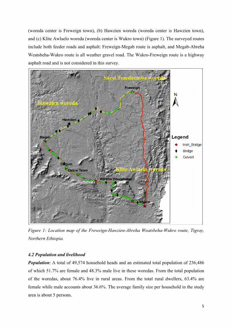
5
(woreda center is Freweign town), (b) Hawzien woreda (woreda center is Hawzien town),
and (c) Klite Awlaelo woreda (woreda center is Wukro town) (Figure 1). The surveyed routes
include both feeder roads and asphalt: Freweign-Megab route is asphalt, and Megab-Abreha
Weatsbeha-Wukro route is all weather gravel road. The Wukro-Freweign route is a highway
asphalt road and is not considered in this survey.
Figure 1: Location map of the Freweign-Hawzien-Abreha Weatsbeha-Wukro route, Tigray,
Northern Ethiopia.
4.2 Population and livelihood
Population: A total of 49,574 household heads and an estimated total population of 236,486
of which 51.7% are female and 48.3% male live in these woredas. From the total population
of the woredas, about 76.4% live in rural areas. From the total rural dwellers, 63.4% are
female while male accounts about 36.6%. The average family size per household in the study
area is about 5 persons.

6
Livelihood of the communities: The communities in the watersheds have been food insecure
for a number of reasons, among which are: (a) land degradation mainly erosion and reduction
in soil fertility, (b) due to short rainy season coupled with high rainfall variability between
seasons, (c) the small land size that rarely exceeds 0.5 ha per family and (d) absence of
irrigation practices.
The dominant mode of livelihood of the population is mixed crop and livestock agriculture.
The predominant agricultural practice in the study area is traditional crop-livestock mixed
farming. The major rainfed crops grown is dominated by cereals and legumes such as Barely,
Wheat, Beans, Vetch, Peas, Faba Beans, Lentils, Teff, Maize while the irrigated crops include
Maize, Tomato, Onion, Pepper, Carrot, Cabbage and fruit trees. Other income sources
include quarrying (stone gathering), wages, pity trade, etc. In general, livelihood
diversification of the study area increases with market proximity.
Rainfed-agriculture: The total cultivated land in the area in 2009/2010 production year was
34,911.1 hectare while the corresponding total yield was 793,540.2 quintal. It was found out
that, with an average of 13.1 quintal/ha, the average annual yield varied from 7.9 quintal/ha
to 22.7 quintal/ha. The major factor contributing to the variability is the unreliability of
rainfall both in amount and distribution. The other factors causing low productivity include
poor soil fertility, poor agricultural inputs including improved seeds and fertilizer, poor
tillage practices and weed problems. As a result, farmers do not produce sufficient food and
are exposed to year round food aid.
The population of the study area which is similar to the other parts of the country grows by
2.5% which requires parallel growth in the agricultural commodity sector. However,
recurrent drought and low yields have caused the growth rate of food production to lag
behind the rate of population growth.
Irrigated agriculture: Various water harvesting technologies ranging from individual farm
household to community level are used in the study area for irrigation. Some of these include
hand-dug wells, ponds (Horoye), river diversions and earth dams. The total irrigated land in
the area in the year 2013 was estimated to be about 1800 hactar (TBoARD, 2013).
7
4.3 Topography and climate
The landscape of the project area is associated with wide ranges of landforms which include
plateaus, mountains, rolling hills, steep hill slopes and deeply incised valleys. The slope
gradients range from flat plains to over 40%. The slope range renders itself very conveniently
to both on-farm and off-farm water harvesting practices.
The catchment encompasses a wide range of altitude starting from 1,500 to 3,300 m.a.s.l with
diverse rock types (e.g., sedimentary, metamorphic and igneous origin) and various cover
types and land use. The mean annual rainfall and temperature of the area varies from 552 mm
– 767 mm, and 16 – 20° C respectively.
The climate of the project area is classified as semi-arid, with erratic and torrential rainfall
that often lasts for not more than 3 months (end of June to beginning of September). Actual
and potential evapotranspiration are about 540 mm and 1,390 mm respectively.
5. Geohydrology and groundwater potential
5.1 Geohydrology of the route
The geohydrology of Tigray region is highly variable depending on a number of parameters,
in particular: (a) rock/soil types and their hydraulic properties, (b) terrain conditions (slope
angle and shape), (c) land cover and soil/water conservation measures at upper watersheds,
and (d) size of the recharge area vis-à-vis the receiving area.
Though the northern Ethiopia is characterized by various rock and soil types, the study area is
mainly dominated by the following rock and soil types: (a) Metamorphic rocks, (b) Paleozoic
sediments (Tillites/post-glacial sediments, and Enticho Sandstone), (c) Mesozoic sediments
which include Adigrat sandstone, Antalo limestone and shale, and (d) Unconsolidated
deposits (mainly residual soils and alluvial types). The geohydrological characteristics of
these rocks and soils is summarized as follows:
5.1.1 Metamorphic rocks:
According to various authors (e.g. Mohr 1983; Tadesse et al. 2003) the metamorphic rocks in
the area include metasediments and metavolcanics. These rocks are exposed in limited areas
(along deep rivers) in the area. The metasediments are generally classified as rocks with low
permeability and poor aquifer characteristics. In many cases, however, these metasediments

8
have moderate aquifer characteristics, as a result of weathering, at very shallow depths (not
exceeding 10 meters). Fractured metavolcanic rocks have relatively higher permeability at
shallow depths (in most cases not exceeding 50meter deep). With increase in depth the
degree of fracturing and hence the permeability tends to reduce unless it is affected by major
fault systems. Metavolcanic rocks are, therefore, classified as rocks with moderate aquifer
characteristics for groundwater development. Due to this, many of the valley floors underlain
by metamorphic rocks are among the areas with extensive shallow groundwater development
in the area.
5.1.2 Paleozoic sediments:
These rocks include Enticho sandstone, and glacial tillites(Mohr, 1962, 1967, 1983; Kazmin,
1972).
5.1.2.1 Enticho Sandstone
The majority of the route is dominated by Enticho sandstone. These rocks are fine to medium
grained, slightly to moderately weathered, horizontally bedded, jointed sandstone with sand-
silt matrix and poorly sorted pebbles and boulders. When weathered (mostly not exceeding
15m as observed from existing hand-dug wells), the Enticho sandstone has moderate to high
permeability. With increase in depth, the permeability tends to decrease. Among the
productive shallow wells in the areas are the valley floors underlain by Enticho sandstones
along the route.
5.1.2.2 Glacial Tillites
These rocks are exposed only in limited areas along the route. Glacial Tillites have generally
low permeability due to the sand-silt-clay matrix in these rocks. In some cases they are
interbedded with thin layers of silty limestone, and with poorly sorted pebbles and boulders.
At shallow depth (not exceeding 5m depth), however, these formations have moderate
permeability due to weathering.
5.1.3 Mesozoic sediments
Mesozoic sediments: these rocks were studied by various authors (e.g. Assefa, 1981, 1991;
Russo et al., 1999). From the Mesozoic rocks, those exposed along the route or adjacent to
the route include: Adigrat sandstone, and Antalo group (limestone, shale):

9
5.1.3.1 Adigrat Sandstone
Though these rocks were not encountered along the road, they are exposed close to the
routes. These Adigrat Sandstones are characterized by high degree of fracturing. The
geomorphological expression of these rocks (ridge forming) dictates their suitability as
recharge zones to the valley floors. These rocks are categorized as poor aquifers for
groundwater development.
5.1.3.2 Antalo limestone
Antalo limestone is exposed along the Abreha Weatsbeha-Wukro route. These rocks are hard
limestone and shale intercalations. As a unit, it is classified as a rock with moderate aquifer
characteristics. In many places, cold springs emerge at the contact of the limestone beds with
the intercalating shales and marls.
5.1.3.3 Agula Shale
Agula shale is exposed only in limited areas. This formation is characterized by shale, marl
and claystone which is intercalated with fine crystalline black limestone. Generally, this unit
is having poor aquifer characteristics. Due to the weathering of these rocks at shallow depth,
however, they contain shallow groundwater.
5.1.4 Unconsolidated deposits
These include alluvial and residual deposits. The permeability and productivity varies from
place to place depending on grain size, sorting and thickness. The thickness of these
sediments is limited in the area; mostly not exceeding 10 meter.
The silty sand soils are the most dominant ones along the whole route and results of inverse
auger hole test in these soils revealed that these soils have permeability which range from
2.5*10-2 cm/sec to 3.4*10-3cm/sec. Most of the unconsolidated sediments along the route are
categorized as good aquifers for shallow groundwater development. This is confirmed by the
extensive shallow groundwater development in the plains of the study area.
5.1.5 Geological structures
Different types of geological structures characterize the study area. Many water supply wells
have been developed in fractured aquifers in the area and in other parts of Tigray.

10
5.2 Groundwater development
In the three woredas (Saesi Taseda Emba, Hawzien and Klite Awalelo), the flat plains and
valley floors are associated with shallow groundwater development for water supply and
irrigation purposes (Figure 2a, b). In recent years, small-scale irrigation using shallow
groundwater is practiced, especially since the year 2000. In these three woredas, over 3000
hand-dug wells have been developed for irrigation use in the years 2011-2013 alone.
Assessment/inventory of representative hand-dug wells show variable depth of water table.
At the end of rainy season, the water table varied from zero to about 1m below the ground
surface. In the dry season, however, the measured water level varied from dry to 5m depth.
Food security is strongly associated with water security and hence irrigation development in
the area.
Groundwater is the main source of water for domestic use in the area. In the last five years,
however, shallow groundwater is commonly used for small-scale irrigation in the area. As a
result, out of the total 1800hectar irrigated land in the year 2013, a total of 550hectar of land
was irrigated using shallow groundwater systems. The maximum land size that a single
farmer is able to irrigate so far (using shallow groundwater as well as other sources) in the
area is 30% of the cultivable land. The reason for not able to irrigate more land is related to
shortage of water.
Though not strongly linked and coordinated with water harvesting from roads, natural
resources management efforts which include construction of deep-trenches and percolation
ponds as well as biological measures (afforestation) and area closures are implemented in the
area.

11
Figure 2a: A hand-dug well developed in areas underlain by Enticho Sandstone along the
Freweign-Hawzien road (close to the road), Tigray, Northern Ethiopia. The well is used for
small-scale irrigation.
Figure 2b: A hand-dug well developed in areas underlain by Enticho Sandstone along the
Megab-Abreha Weatsbeha road, Tigray, Northern Ethiopia. The well is used for small-scale
irrigation.

12
Figure 2c: Hand-dug wells developed in areas underlain by Glacial Tillites/post-glacial
sediments in Klite Awlaelo woreda, Tigray, Northern Ethiopia.
6. Effects of water from roads
In order to evaluate the effects of water from roads, detailed survey was done for the route:
Freweign-Hawzien-Megab-Abreha Weatsbeha-Wukro road, Tigray, Northern Ethiopia. The
Freweign-Hawzien-Megab route is asphalt, while the route Megab-Abreha Weatsbeha-
Wukro road is a gravel road. The survey involved detailed assessment and documentation of:
(a) locations of Culverts, Irish bridges, and Bridges, (b) areas affected by gully erosion, (c)
sites affected by water logging and flooding, and (d) sites where efforts have been made to
implement different soil and water conservation measures along the 5Km radius from the
main route. Results of the study is given in the following sections.
6.1 Locations of culverts and bridges
A total of 118 culverts (110 pipe culverts and 8 box culverts), 4 Irish bridges, and 8 bridges
have been inventoried along the route (Figure 1). The pipe culverts have variable capacity
that range from single pipe to triple ones.

13
6.2 Negative effects of water from roads
Detailed inventory and assessment of the effects of water from roads was carried out in the
period July to September 2013. Results show that water from roads have caused a number of
problems which include: (a) erosion (downstream areas and road sides), (b)
siltation/sedimentation of downstream, upstream, and side drainage areas, (c) water logging
(upstream and downstream areas), and (d) damage on dwelling houses and on water
harvesting systems (groundwater wells and ponds).
6.2.1 Erosion problems
From the total of 118 culverts, gully erosion was recorded at downstream of 68 culvert
locations (Figure 3a, b, c, d). The size of the gullys were found to be variable: depth range
from about 1m to 4.5m, width vary from 1.5m to 5m, and length range from 10m to over
500m. In 35 locations, road side erosion was recorded (Figure 3e). Expansion of gullys and
creation of new ones is not uncommon. In all the erosion affected sites, gullys have
terminated after reaching the bedrock. No major gully erosion problem was noted at Irish
bridge locations. Moreover, since most of the bridges were constructed on a hard rock, no
active erosion was recorded on the major bridge sites along the route.
Figure 3a: Erosion at upstream side of a culvert in Freweign area, Tigray, Northern
Ethiopia.

14
Figure 3b: Erosion at downstream side of a culvert in Freweign area, Tigray, Northern
Ethiopia.
Figure 3c: Downstream gully erosion due to water from a culvert in Freweign area, Tigray,
Northern Ethiopia.
15
Figure 3d: Downstream gully erosion due to water from a culvert in Abreha Weatsbeha area,
Tigray, Northern Ethiopia.
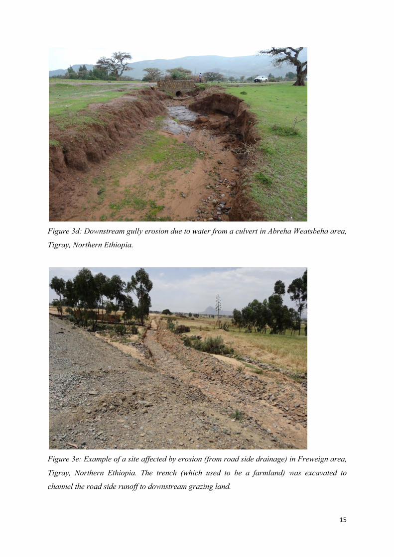
Figure 3e: Example of a site affected by erosion (from road side drainage) in Freweign area,
Tigray, Northern Ethiopia. The trench (which used to be a farmland) was excavated to
channel the road side runoff to downstream grazing land.

16
In order to evaluate the in-situ moisture distribution across a gully site, soil samples were
collected from field and analyzed in the laboratory. Results of the analysis (Table 1) show
that the in-situ moisture content of the soil increases with increase in distance from the gully.
Close to the gully the moisture content was found not to be more than 8% but at 10m away
from the gully the moisture content reached upto 45%.
Sample Cod Distance from gully (m) Moisture content (%) Soil type
LS01 1 5 Silty sand
LS02 5 18 Silty sand
LS03 10 38 Silty sand
RS01 1 8 Silty sand
RS02 5 26 Silty sand
RS03 10 45 Silty sand
Table 1: Moisture distribution across a gully (LS= Left Side; RS= Right Side) in Freweign
area, Tigray, Northern Ethiopia. Note that the depth of sampling was 0.5m and the soil type
in the site is silty sand type. Samples were collected one day after a 50mm rainfall in the
area.
The results of the laboratory test was in line with the moisture content of the crops; crops
close to the gully have shown early maturation due to less moisture content in the soil (Figure
4).

17
Figure 4: Downstream view of a gully created with water from a culvert in Freweign area,
Tigray, Northern Ethiopia. The moisture content and the productivity of land was found to
reduce with decrease in distance from the gully.
6.2.2 Siltation/sedimentation problems
At 15 culvert locations and 5 road sides, sedimentation problems were recorded. As a result,
farmlands have been affected. In some areas, such negative effects are becoming
opportunities for sand mining (Figure 5).
Figure 5a: Damaged crops due to siltation/sedimentation problems with water from a culvert
in Freweign area, Tigray, Northern Ethiopia.
18
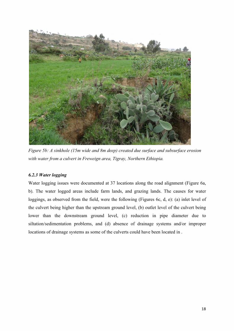
Figure 5b: A sinkhole (15m wide and 8m deep) created due surface and subsurface erosion
with water from a culvert in Freweign area, Tigray, Northern Ethiopia.
6.2.3 Water logging
Water logging issues were documented at 37 locations along the road alignment (Figure 6a,
b). The water logged areas include farm lands, and grazing lands. The causes for water
loggings, as observed from the field, were the following (Figures 6c, d, e): (a) inlet level of
the culvert being higher than the upstream ground level, (b) outlet level of the culvert being
lower than the downstream ground level, (c) reduction in pipe diameter due to
siltation/sedimentation problems, and (d) absence of drainage systems and/or improper
locations of drainage systems as some of the culverts could have been located in .

19
Figure 6a: Water logging at upstream side of a road along the Freweign-Hawzien route in
Tigray, Northern Ethiopia.
Figure 6b: Water logging behind an embankment road along the Frewign-Hawzien road,
Northern Ethiopia

20
Figure 6c: Outlet level of the culvert is lower than the downstream ground level, leading to
ponding of water at upstream of the culvert in Freweign-Hawzien route, Tigray, Northern
Ethiopia.
Figure 6d: Siltation is causing reduction in the size capacity of the pipe culvert leading to
water logging problems along the Frewign-Hawzien route, Tigray, Northern Ethiopia.

21
Figure 6e: Siltation is causing reduction in pipe size leading to water logging in Debre Tsion
area (along the Hawzien-Abreha Weatsbeha), Tigray, Northern Ethiopia.
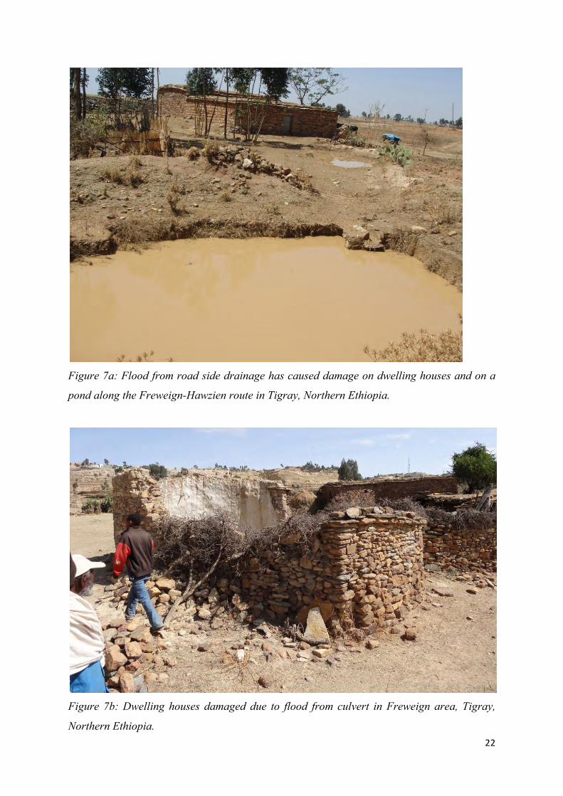
6.2.4 Flooding
In 34 locations, water from culverts and road side drains have caused flooding of farmlands,
ponds, and shallow hand-dug wells. The most damaging flooding with water from culverts
and road side drainage were recorded on 18 locations along the route (e.g. Figure 7a, b). It
has caused: (a) damage to 8 dwelling houses, (b) silting-up of 4 ponds and 5 shallow
groundwater wells, (c) increase in the size and depth of previously exiting gullys, and (d)
damage to farmlands and crops.
22
Figure 7a: Flood from road side drainage has caused damage on dwelling houses and on a
pond along the Freweign-Hawzien route in Tigray, Northern Ethiopia.
Figure 7b: Dwelling houses damaged due to flood from culvert in Freweign area, Tigray,
Northern Ethiopia.
23
6.3 Positive effects of water from roads
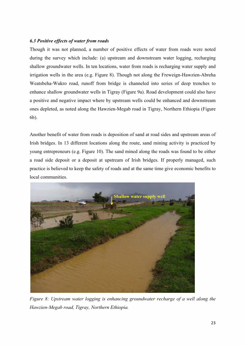
Though it was not planned, a number of positive effects of water from roads were noted
during the survey which include: (a) upstream and downstream water logging, recharging
shallow groundwater wells. In ten locations, water from roads is recharging water supply and
irrigation wells in the area (e.g. Figure 8). Though not along the Freweign-Hawzien-Abreha
Weatsbeha-Wukro road, runoff from bridge is channeled into series of deep trenches to
enhance shallow groundwater wells in Tigray (Figure 9a). Road development could also have
a positive and negative impact where by upstream wells could be enhanced and downstream
ones depleted, as noted along the Hawzien-Megab road in Tigray, Northern Ethiopia (Figure
6b).
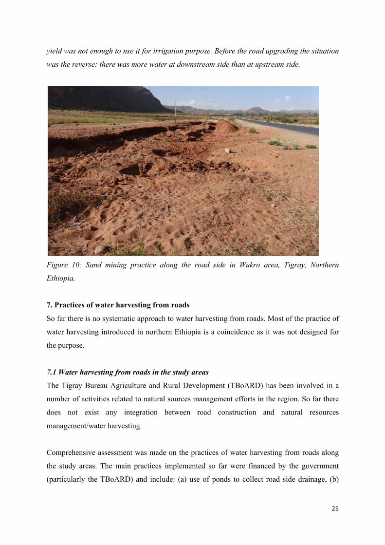
Another benefit of water from roads is deposition of sand at road sides and upstream areas of
Irish bridges. In 13 different locations along the route, sand mining activity is practiced by
young entrepreneurs (e.g. Figure 10). The sand mined along the roads was found to be either
a road side deposit or a deposit at upstream of Irish bridges. If properly managed, such
practice is believed to keep the safety of roads and at the same time give economic benefits to
local communities.
Figure 8: Upstream water logging is enhancing groundwater recharge of a well along the
Hawzien-Megab road, Tigray, Northern Ethiopia.

24
Figure 9a: Water from a bridge is channeled into series of deep trenches which are acting as
recharge to shallow groundwater system in Negash area, Tigray, Northern Ethiopia. Shallow
groundwater in the area is used for water supply and irrigation purposes. A shallow well
which was dry in the year 2005 is now used for small-scale irrigation.
Figure 9b: Typical example of effects of road construction on shallow groundwater along the
Hawzien-Megab road, Tigray, Northern Ethiopia. In the upstream side of the road shallow
wells are developed for irrigation use. In the downstream side wells were excavated but the
25
yield was not enough to use it for irrigation purpose. Before the road upgrading the situation
was the reverse: there was more water at downstream side than at upstream side.
Figure 10: Sand mining practice along the road side in Wukro area, Tigray, Northern
Ethiopia.
7. Practices of water harvesting from roads
So far there is no systematic approach to water harvesting from roads. Most of the practice of
water harvesting introduced in northern Ethiopia is a coincidence as it was not designed for
the purpose.
7.1 Water harvesting from roads in the study areas
The Tigray Bureau Agriculture and Rural Development (TBoARD) has been involved in a
number of activities related to natural sources management efforts in the region. So far there
does not exist any integration between road construction and natural resources
management/water harvesting.
Comprehensive assessment was made on the practices of water harvesting from roads along
the study areas. The main practices implemented so far were financed by the government
(particularly the TBoARD) and include: (a) use of ponds to collect road side drainage, (b)
26
channeling water from culverts and road side drainage into series of deep trenches, and (c)
shallow groundwater development upstream of Irish bridges.
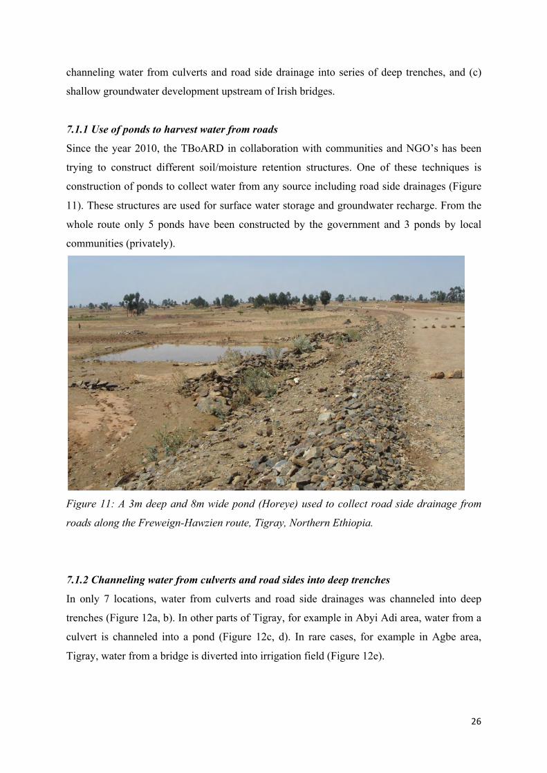
7.1.1 Use of ponds to harvest water from roads
Since the year 2010, the TBoARD in collaboration with communities and NGO’s has been
trying to construct different soil/moisture retention structures. One of these techniques is
construction of ponds to collect water from any source including road side drainages (Figure
11). These structures are used for surface water storage and groundwater recharge. From the
whole route only 5 ponds have been constructed by the government and 3 ponds by local
communities (privately).
Figure 11: A 3m deep and 8m wide pond (Horeye) used to collect road side drainage from
roads along the Freweign-Hawzien route, Tigray, Northern Ethiopia.
7.1.2 Channeling water from culverts and road sides into deep trenches
In only 7 locations, water from culverts and road side drainages was channeled into deep
trenches (Figure 12a, b). In other parts of Tigray, for example in Abyi Adi area, water from a
culvert is channeled into a pond (Figure 12c, d). In rare cases, for example in Agbe area,
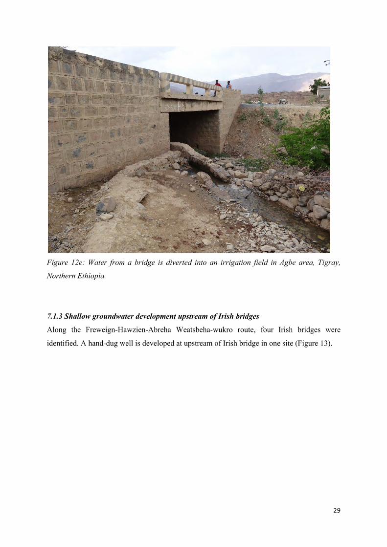
Tigray, water from a bridge is diverted into irrigation field (Figure 12e).

27
Figure 12a: Runoff from culverts being channelled to deep trenches in Hawzien area, Tigray,
Northern Ethiopia (Photo by Kifle Woldearegay and Mohammed Abdelkadir, July 24, 2013).
Figure 12b: Water from culverts is channeled into series of deep trenches to reduce erosion
at downstream areas and enhance the groundwater system along the Hawzien-Megab area,
Tigray, Northern Ethiopia.

28
Figure 12c: Water from culverts is channeled into a pond in Abyi Adi area, Tigray, Northern
Ethiopia.
Figure 12d: Pond (45m long, 30m wide and 7m deep) in which water from culverts is
channeled into in Abyi Adi area, Tigray, Northern Ethiopia. Pond mentioned in Figure 12c.
29
Figure 12e: Water from a bridge is diverted into an irrigation field in Agbe area, Tigray,
Northern Ethiopia.
7.1.3 Shallow groundwater development upstream of Irish bridges
Along the Freweign-Hawzien-Abreha Weatsbeha-wukro route, four Irish bridges were
identified. A hand-dug well is developed at upstream of Irish bridge in one site (Figure 13).

30
Figure 13: A hand-dug well is developed at upstream of an Irish bridge along the Hawzien-
Abreha Weatsbeha route in Tigray, Northern Ethiopia.
7.2 Practice of water harvesting from roads in other areas of Tigray
In addition to the practices of water harvesting from roads indicated above, the following
additional techniques have been documented applied to harvest water from roads in Tigray
but outside of the Freweign-Hawzien-Abreha Weatsbeha-Wukro route:
7.2.1 Spring capture from roads
Though not commonly used, spring capture from road cuts is practiced in Tigray, mainly for
water supply purposes (e.g. Figure 14).

31
Figure 14: Spring developed from a road cut which is now used for rural water supply in
Megulat area, Tigray, Northern Ethiopia.
7.2.2 Use of borrow pit
The use of borrow pits as surface water storage and groundwater recharge is an option of
water harvesting from roads which was not considered until recently in Tigray. As part of the
contract agreement between a contractor and client, borrow pits are often expected to be
filled and given back to land owners. It is often the case that even if the land is filled-back, it
can not be productive as what it used to be.
In recent years, because communities are becoming aware of the importance of water, borrow
pits are being used as surface storages and groundwater recharge in limited areas of Tigray
(e.g. Figure 15a, b). In some sites the borrow pits are close to a terrains where seepage water
comes from the hillslopes. In the case of borrow pit in Axum area seepage water from the
road sides and the hillslopes is contributing to the base-flow to: the borrow pit which is
currently used for swimming, livestock, groundwater recharge and irrigation.

32
Figure 15a: A borrow pit (250m long, 80m wide and 15m seep) which is currently used for
irrigation development in Axum area, Tigray, Northern Ethiopia.
Figure 15b: A borrow pit (400m wide, 650 long, and 10m deep) which is yet to be used for
irrigation in Sheraro area, Tigray, Northern Ethiopia.

33
The borrow pit in Sheraro area was developed using blasting and has left rocky reservoir
floors. The borrow pit is used for swimming, washing and small-scale irrigation. Until mid
2014, 5 people are reported to have been drowned in the pit; causing a serious concern by the
communities. The local and regional government are planning to change the site into proper
water harvesting after getting advice from the UPgro catalysis grant holders. The pond is
recharged from the surrounding stream as the level of water in the pond is lower than the
stream level.
7.2.3 Shallow groundwater upstream and downstream of roads
In different parts of Tigray, a numbers of scenarios were noted in relation to road
construction and downstream-upstream groundwater conditions. In some areas, for example
in Edaga Hamus area (Figure 16a), road upgrading has increased the upstream groundwater
storage which later on was turned into a pond by excavating the sand aquifer. Now this water
is used for irrigation and livestock.
Figure 16a: Upgrading of the road has resulted in an increase in the groundwater storage at
upstream of the road in Edaga Hamus area, Tigray, Northern Ethiopia.

34
In other areas, after upgrading of a road the embankment was raised to about 2m above
original ground level and this lead to creation of water logged areas at upstream of the road.
This effect has improved both the upstream and downstream groundwater wells, for example,
in Shire area, Tigray, Northern Ethiopia (Figure 16b).
The other scenario noted from the survey in different parts of Tigray, for example in Shire
(Figure 16c) and Negash (Figure 16d) areas, is that due to road upgrading, shallow wells at
upstream of the roads which used to dry fast have improved their yield. This is attributed to
the reduction in permeability of the soils at the road foundation due to compaction.
Figure 16b: Upgrading of the road has resulted in an increase in the groundwater recharge
for both downstream and upstream areas of the road in Shire area, Tigray, Northern
Ethiopia.

35
Figure 16c: Upgrading of the road has enhanced the groundwater yield in Shire area,
Tigray, Northern Ethiopia.
Figure 16d: Upgrading of the road has enhanced the groundwater yield in Negash area,
Tigray, Northern Ethiopia. Before the upgrading of the road, the well used to be dry.
36
8. Current road design approach and stakeholder involvement
8.1 Current road design approach
In Ethiopia, the road sector is generally considered as well organized and equipped with
standard design manuals and guidelines. The Ethiopian Roads Authority has developed
design manuals for the different components of a road. Since issues of road and water is more
related to geotechnical, hydrological and environmental aspects, review was made on the
existing road design manual (specifically the drainage design manual of ERA - 200):
From the review, the following points are noted:
§ According to the ERA manual, drainage systems are designed to: (a) to prevent road
damage during the most usual floods, and (b) to minimize the modifications in the
hydrology of the area.
§ No design consideration is given to water harvesting except for certain detention
structures in which the objective is not to harvest the water but to reduce the peak
discharge and only detain runoff for some short period of time.
§ No design consideration is given to any possibility of developing groundwater
recharge systems.
As indicated in section 7 of this report, different water harvesting practices have been
implemented in Tigray region. These practices were mainly introduced by the TBoARD,
NGOs and communities as part of the extensive natural resources management, and moisture
conservation efforts in the region. It can be stated that the TBOARD has been trying to fix the
problems created by water from roads while the other sectors have little knowledge and
understanding on options of water harvesting from roads.
8.2 Stakeholder involvement
The ERA manual clearly states the following “Coordination between concerned agencies
during the project-planning phase will help produce a design that is satisfactory to all.
Substantial cost savings and other benefits can be realized frequently for highway and water
resource projects through coordinated planning among the various regional and local
agencies that are engaged in water-related activities (flood control and water resources
planning, etc.). Interagency cooperation through, for instance, the Ministry of Agriculture,
Ministry of Water Resources, and regional and local administrations, is an essential element
in serving the public interest”.

37
However, from UPGro Catalyst research it was learned that there is less coordination among
the different stakeholders involved with road design and construction, water resources
development, agricultural, and environmental offices. Especially, the involvement of
communities in the planning and implementation of road development is non-existent.
9. Opportunities for water harvesting from roads
The potential for water harvesting is very high for the fact that:
§ Shallow groundwater is the main source of water for small-scale irrigation and
drinking in the area. One of the major problems with groundwater in the area is the
lowering of the water table especially in the dry season. Through proper management
of flood water from roads the groundwater could be recharged effectively.
§ The geohydrology of the areas is generally characterized by shallow unconfined
aquifer systems. The soil in the area is dominantly silty sand which makes it very
favorable for groundwater recharge. Groundwater systems could be enhanced through
a number of options which include: (a) construction of percolation ponds, check-
dams, and deep trenches, (b) controlled guiding of runoff from road sides, culverts
and bridges into farmlands in the form of spate systems, and (c) use of borrow pits as
surface water storage and groundwater recharge.
§ The communities along the roads have indicated that shortage of water is a critical
problem. Now that there is flood water from roads, it can be considered as an
opportunity rather than a threat if properly utilized for enhanced groundwater
recharge and retention.
§ Different organizations like TBoARD, NGO’s and the communities are actively
involved in natural resources management and moisture conservation activities in
Tigray. Moreover, the bureau of water resources is involved in water harvesting from
all sources while bureau of transport, road and construction is involved in road
development. So far those organizations involved in road design and construction and
those responsible for natural resources management and water resources development
have been operating independently. Runoff from roads is a major problem to the on-
going soil and water conservation efforts in Tigray. On the other hand, depletion of
shallow groundwater is a major concern of the bureau of water resources. There is
therefore a need for integrated planning and implementation of road development and
water harvesting through involvement of multi-stakeholders including communities.
38
10. Recommendations: Design approach issues
This study has revealed that so far water from roads is considered as a threat not only in
the study area as well as in other parts of Ethiopia. The only efforts done so far to convert
these threats into benefits are those tried by the TBOARD, NGO’s and the communities.
It is therefore to consider the following design approaches in road development:
§ When planning road development in a certain catchment it is very important to
look at options on how water from a road is going to be harvested for economic
benefit of the local communities. This needs to be part of the TOR in the design of
the roads.
§ The location, alignment and size of drainage systems (culverts, etc) should be
designed with the objective of harvesting water from roads either to be collected
into surface water reservoirs or used for groundwater recharge. This requires a
comprehensive evaluation of the surface as well as subsurface geohydrology of
the areas.
§ Development of geological construction materials is one of the major activities in
road construction and this leads to creation of borrow pits. It is advisable that the
location and size of the borrow pit to be developed is identified during/or even
before the final design of the road is made. Based on this the locations of culverts
and even the road alignment could be designed in such a way that water from
roads (road side drainages, culverts, bridges etc) is channeled into borrow pits.
The option of using borrow pits as surface water storage as well as groundwater
recharge is one of the best alternatives to be considered as part of the road design
and construction.
§ Water harvesting from roads could be implemented effectively if road
development in a certain catchment is considered as part of the
watershed/catchment development plan. Through such approach, the possible
negative effects of water from roads and options for mitigating such problems
through water harvesting and natural resources management could be
implemented.
§ Water harvesting from roads involves multi-stakeholders. For water harvesting
from roads to be implemented effectively there should be strong linkages and
cooperation among the sectors through a more powerful body but with clear tasks

39
and responsibilities for each stakeholder. From the catalyst grant it was learned
that the cooperation and linkages among the stakeholders is more important at
lower levels of the administration in which the final beneficiaries (communities)
are involved.