water quality and hydrology of the bighead river,...
TRANSCRIPT
WATER QUALITY AND HYDROLOGY
OF THE
BIGHEAD RIVER
GREY COUNTY
Ministry
of the
Environment

Copyright Provisions and Restrictions on Copying:.
This Ontario Ministry of the Environment work is protected by Crown copyright (unless otherwise
indicated), which is held by the Queen's Printer for Ontario. It may be reproduced for
non-commercial purposes if credit is given and Crown copyright is acknowledged.
It may not be reproduced, in all or in part. for any commercial purpose except under a licence
from the Queen's Printer for Ontario.
For information on reproducing Government of Ontario works, please contact ServiceOntario
Publications at [email protected]
Water Quality and Hydrology
of the
Bighead River
Grey County
Water Resources Assessment Unit
Technical Support
Southwestern Region
Field Work - 1980
Report Preparation - 1982
TABLE OF CONTENTS
Page
1.0 SUMMARY, DISCUSSION AND CONCLUSIONS 1
2.0 INTRODUCTION 5
3.0 METHODS 7
3.1 Hydrology 7
3.2 Water Temperatures 8
3.3 Chemical and Bacterial Data 8
3.4 Storm Event 8
3.5 Bottom Fauna 8
3.6 Aquatic Vegetation 9
4.0 DISCUSSION OF RESULTS 9
4.1 Hydrology 9
4.2 Water Temperatures 12
4.3 Suspended Solids 14
4.4 Phosphorus 14
4.5 Nitrogen 16
4.6 Other Chemical Parameters 16
4.7 Storm Conditions 18
4.8 Bacteria 18
4.9 Bottom Fauna 20
5.0 AQUATIC VEGETATION 20
6.0 GROUNDWATER 21
i

Page
APPENDIX I 23
Average Mean Monthly Flow Bighead River Near Meaford 24
Bighead River Flow Data - May-October 1980
Summary of 30 selected streamflow sites 25
Bighead River Flow Data - May-October 1980 Summary of nine main
sites and their percent contribution to total flow in the Bighead River 28
APPENDIX II 29
Macroinvertebrates collected at 41 sample sites
on the Bighead River and tributaries 30
APPENDIX III 52
Water quality data May-November 1980 53
Water quality data collected during a heavy
rainfall event July 15, 1980 58
ii

LIST OF FIGURES
Page
Figure 1. Sampling Sites On The Bighead River May-November 1980. 6
Figure 2. Percent Contribution To Total Flow At Federal Gauge
02FB010 From 8 Selected Sites On The Bighead River,
August 25-27, 1980. 10
Figure 3. Water Temperature Ranges At Selected Stations
on The Bighead River, August 18-28, 1980. 13
Figure 4. Average Levels of Total Phosphorus at 29 Locations
on The Bighead River, May-November, 1980. 15
Figure 5. Average Levels of Nitrate at 27 Locations
on The Bighead River, May-November 1980. 17
Figure 6. Bacteriological Concentrations at 36 Locations
On The Bighead River, May- November 1980. 19
LIST OF TABLES
Page
Table 1. Bighead River Near Meaford Daily Discharge in
Cubic Metres Per Second For 1980. 11
iii
1.0 SUMMARY, DISCUSSION AND CONCLUSIONS
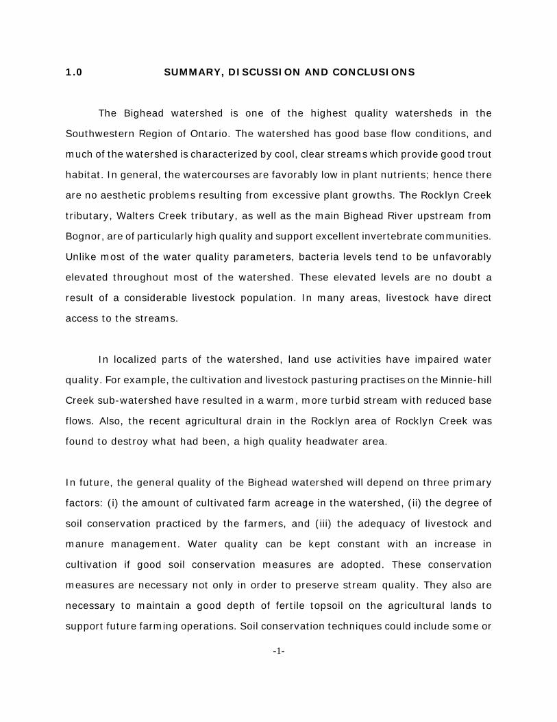
The Bighead watershed is one of the highest quality watersheds in the
Southwestern Region of Ontario. The watershed has good base flow conditions, and
much of the watershed is characterized by cool, clear streams which provide good trout
habitat. In general, the watercourses are favorably low in plant nutrients; hence there
are no aesthetic problems resulting from excessive plant growths. The Rocklyn Creek
tributary, Walters Creek tributary, as well as the main Bighead River upstream from
Bognor, are of particularly high quality and support excellent invertebrate communities.
Unlike most of the water quality parameters, bacteria levels tend to be unfavorably
elevated throughout most of the watershed. These elevated levels are no doubt a
result of a considerable livestock population. In many areas, livestock have direct
access to the streams.
In localized parts of the watershed, land use activities have impaired water
quality. For example, the cultivation and livestock pasturing practises on the Minnie-hill
Creek sub-watershed have resulted in a warm, more turbid stream with reduced base
flows. Also, the recent agricultural drain in the Rocklyn area of Rocklyn Creek was
found to destroy what had been, a high quality headwater area.
In future, the general quality of the Bighead watershed will depend on three primary
factors: (i) the amount of cultivated farm acreage in the watershed, (ii) the degree of
soil conservation practiced by the farmers, and (iii) the adequacy of livestock and
manure management. Water quality can be kept constant with an increase in
cultivation if good soil conservation measures are adopted. These conservation
measures are necessary not only in order to preserve stream quality. They also are
necessary to maintain a good depth of fertile topsoil on the agricultural lands to
support future farming operations. Soil conservation techniques could include some or
-1-
all of the following, depending on the characteristics of each particular farm.
(a) conservation tillage (e.g. chisel ploughing) and cross-slope tillage
(b) grassed waterways
(c) leaving natural vegetation buffers along streams
(d) leaving wetland areas and hills and erodible areas out of row crop production
(e) good manure management
(f) controlled cattle access
(g) good drain construction (e.g. flatter side slopes and promoting early vegetative
cover)
(h) maintaining natural buffer strips between farmyards and watercourses
(I) strip cropping and crop rotations
All of these conservation measures are currently receiving greater attention by
farmers throughout Southern Ontario. Controlled experiments in a variety of
watersheds including the Palouse watershed in Washington, the Honey Creek
watershed in Ohio, and the Avon River watershed in Southwestern Ontario are being
carried out to evaluate these conservation measures using a benefit/cost approach. In
general, the findings are that the majority of existing soil erosion problems can be
greatly reduced without expensive cost to the farmer over the short term. Over the
long term, it is becoming more apparent that minimizing soil erosion is essential in
order to maintain adequate depths of fertile and well-textured topsoil for future
generations.
Technical assistance and subsidies for erosion control are available through the
Conservation Authorities, or the Ministry of Agriculture and Food. The latter agency has
established a Farm Productivity Incentive Program which provides grants for erosion
control measures and improvements to manure handling systems.
-2-
The recent studies of PLUARG (Pollution from Land Use Activities Reference
Group) have demonstrated that many of the pollutants in the watercourses (e.g.
phosphorus, nitrogen, bacteria, metals) are transported with soil particles. Hence,
erosion control, keeps watercourses relatively free of pollutants for downstream users.
As outlined above, the environmental character and usefulness of the Bighead
in the near future will depend on agricultural conservation. In the distant future,
however, extractive operations could become more significant. Large scale extraction
of the major gravel deposits in the basin could potentially alter the hydrology of the
basin. The present high quality of the fishery and general biological character of the
watershed is largely a result of good. base flows. Any major extractive operation, with
accompanying dewatering could lower water tables and base flows and have a serious
impact on stream ecology.
RECOMMENDATIONS
1. Farmers throughout the Bighead watershed should be encouraged to utilize soil
conservation measures outlined in the Summary and Conclusions section. Such
encouragement should be enhanced by technical and funding assistance
available through the Farm Productivity Incentive Program. of the Ministry of
Agriculture and Food and erosion control programs of the North Grey Region
Conservation Authority.
2. The impact of any future major aggregate extractive operations on the flow
regime and related quality of the Bighead River should be carefully assessed.
-3-

3. Specific farms identified during the course of this study that are contributing
contaminants to the Bighead River as a result of improper manure handling or
storage practices should be subject to follow-up assessment. The co-operation
of the farmers concerned should be solicited in implementing necessary
corrective actions.
-4-

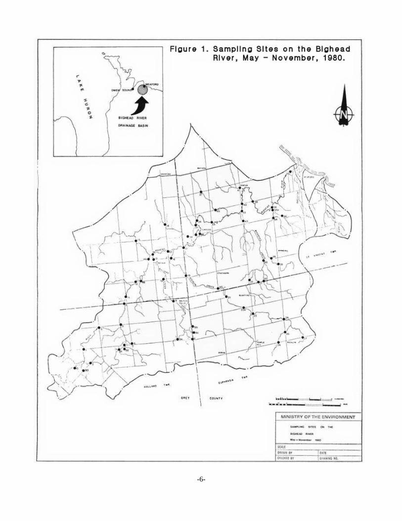
2.0 INTRODUCTION
Watershed studies are periodically carried out by the Ministry of the
Environment. These studies establish an information base for future water resource
management, and for any needed pollution abatement activities. Watershed studies
can be generalized investigations carried out by the Ministry regional office, or they can
be more technical in-depth evaluations carried out by the Ministry's head office with
regional assistance.
A generalized survey of the Bighead watershed was carried out in 1980 to
document existing quality and to focus attention on any developing water resource
problems. The study incorporated historical parameters of concern such as suspended
solids, temperature, nutrients and bacteria. Parameters of more recent concern such
as stable organic compounds and metals, were not included in this study as these
parameters are likely of little or no concern on the Bighead River.
The Bighead flows into Georgian Bay at Meaford (see Figure 1). It drains an area
of 340 square kilometers. The Town of Meaford at the river's mouth (population 4,200)
is the only sizable urban development on the watershed. The major land use on the
watershed is agriculture. The percentage of land under cultivation and row crop
production varies considerably throughout the basin. The Minniehill Creek area, for
example, has a significant percentage of row crops, while agriculture in the Walter's
Creek area remains in a less intensive state. The physiography of the watershed, as
described by Chapman and Putnam (1967) is largely drumlinized till plain. However,
parts of the basin include limestone plain, clay plain, sand plain and till moraine.
-5-
-6-
The watershed gradient averages 3.8 metres per km. Much of the steep
gradient, however, is localized on the upper parts of the watershed as a result of the
Niagara Escarpment. The lower part of the Bighead River proper meanders throughout
relatively flat terrain.
Fishing is the main recreational use of the Bighead. Various sections of the
Bighead provide excellent habitat for resident brook and brown trout, as well as for a
number of migratory species (rainbow trout and salmon).
A number of ponds (about 17) are present on the watershed. A number of small
ponds provide agricultural and recreational uses for their owners. A larger
impoundment at Walters Falls is used to generate power for a feed mill and a sawmill.
Some impoundments are also being used for private fish hatcheries, while others such
as the Bognor Marsh are used for waterfowl production.
3.0 METHODS
3.1 Hydrology
Streamflow data near the mouth of the Bighead, as recorded by Federal
Streamflow Gauge, was reviewed for 1980. Also, during the May to October 1980
period, streamflow was measured at 30 locations on the watershed. Numbers of
measurements at any one of these locations, during the summer period, varied from
1 to 6. Efforts were made to get comparative flows throughout the watershed during
periods of low summer flow.
-7-
3.2 Water Temperatures
During a warm water low-flow period in August, maximum-minimum
thermometers were placed in the stream at 29 sites. Each thermometer was left in a
particular measuring site for at least 72 hours. As weather conditions during the 72
hour period were generally warm and sunny, it is believed that the survey result
reflected the temperatures that were near maximum for the summer.
3.3 Chemical and Bacterial Data
Water samples for chemical and bacteriological analyses were collected at a total
of 41 locations in the watershed between May and November, 1980. At 29 of these
sites samples were collected on at least five dates for chemical analyses and at least
four dates for bacterial analyses. In addition, water quality data from long-term
monitoring station (02FB010), near the mouth of the Bighead was reviewed.
3.4 Storm Event
There was a major rainfall in the Bighead watershed on the morning of July 15,
1980. A total of 58.2 mm of rain was recorded at the Meaford weather office. In order
to evaluate water quality during flood conditions, a total of 19 locations were sampled,
for a variety of chemical parameters.
3.5 Bottom Fauna
Collections of bottom fauna (aquatic insects and other animal life) were made
at 41 stations during August. Quantitative sampling using a Surber sampler, plus two
qualitative samples with a hand sieve were carried out at most stations.
3.6 Aquatic Vegetation
During June and August, observations were made as to the aquatic plant growth
in the Bighead River.
-8-
4.0 DISCUSSION OF RESULTS
4.1 Hydrology
Table 1 illustrates the hydrology, during 1980, for gauging site 02E3010, located
near the mouth of the Bighead River. The data reveal good base flow conditions.
Typical low summer flows at the gauging station are 1-2 cm (cubic metres per second).
The lowest instantaneous flow over the period of record is 0.130 cm. Appendix 1
tabulates the flow data obtained during the survey. During the low flow period of
August 25-27, upstream flow measurements were made at a total of 30 locations on
the watershed.
Figure 2 illustrates flows throughout the watershed during that period. The figure
clearly illustrates excellent base flow conditions in the Rocklyn Creek, Walters Creek,
the upper reaches of the main Bighead, and the tributary draining the Bognor Marsh.
In contrast, Minniehill Creek as well as the tributaries entering the lower Bighead from
the north, had much lower base flows per unit area of watershed size. Once the
Bighead passes the. Sydenham Township-St. Vincent Township line, little increase in
base flow is realized. This is despite the fact that the river still has almost half of the
watershed to flow through.
The hydrology information reveals the extreme importance of the large
groundwater discharges to the upper Bighead watershed. If the groundwater and
surface water regime in the area was interfered with, the hydrological biological
characteristics for the entire river could be greatly depreciated. Potential future
interference could come from such activities as agricultural drainage systems, the
-9-
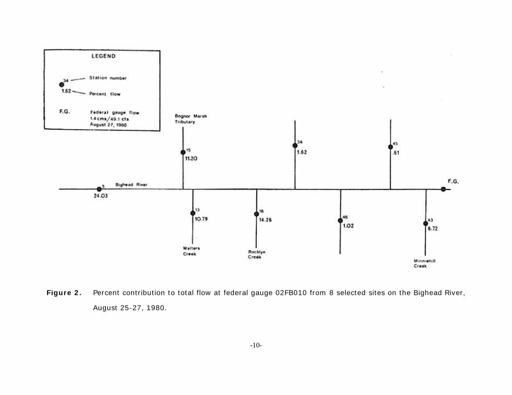
Figure 2. Percent contribution to total flow at federal gauge 02FB010 from 8 selected sites on the Bighead River,
August 25-27, 1980.
-10-

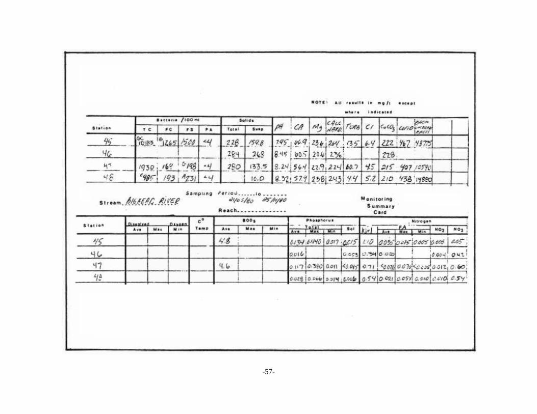
TABLE 1: Bighead River Near Meaford.DAILY DISCHARGE IN CUBIC METRES PER SECOND FOR 1980
FEDERAL STATION NO 02E3010 DRAINAGE AREA 293 KMDAY JAN FEB MAR APR MAY JUN JUL AUG SEP OCT NOV DEC1 6.15 3.20B 1.80B 12.4 6.11 3.27 2.19 3.97 2.81 2.33 3.43 4.092 5.75 3.10B 1.78B 12.2 5.30 3.64 2.08 3.52 3.60 4.39 3.31 4.883 4.60 3.00B 1.75B 12.0 4.84 3.31 1.85 3.45 4.30 7.66 3.26 6.444 4.55B 2.90B 1.66B 14.3 4.42 2.81 1.63 3.05 2.83 13.2 3.78 8.055 4.59B 2.75B 1.60B 13.9 E 4.18 2.49 1.49 3.25 2.23 7.41 4.60 6.366 4.28 2.71B 1.58B 12.5 E 3.90 2.61 1.31 3.75 1.90 5.47 4.12 5.367 4.09 2.70B 1.56B 11.5 E 4.23 3.54 1.36 7.19 1.53 4.50 6.14 6.538 4.07 2.65B 1.54B 10.3 E 4.09 3.23 1.59 9.52 1.61 3.89 7.87 26.6 9 4.41 2.60B 1.52B 10.4 E 3.84 2.76 1.46 5.14 1.53 3.45 7.01 30.3 10 4.52 2.45B 1.50B 11.8 E 3.62 2.49 1.34 3.83 1.49 3.10 6.25 14.4 11 17.6 2.50B 1.49B 11.5 E 3.48 2.26 1.31 3.40 1.50 3.20 4.78 11.0 12 24.1 2.45B 1.48B 11.0 E 3.46 2.05 1.21 3.06 1.33 5.14 4.34 10.2 B13 16.7 2.40B 1.47B 10.5 E 3.32 1.84 1.01 2.95 1.37 4.62 4.11 9.40B14 16.6 2.35B 1.46B 15.0 E 3.49 1.71 1.04 2.72 1.75 3.87 5.95 8.60B15 13.3 2.32B 1.45B 28.8 3.27 1.68 8.17 2.50 1.70 3.44 4.93 8.10B16 11.1 2.30B 1.40B 17.2 3.07 1.81 7.13 2.30 1.50 3.10 4.20 7.40B17 11.3 2.25B 7.30B 12.7 2.82 1.63 10.5 2.11 4.20 3.02 3.83 7.00B18 14.6 2.22B 23.0 B 10.6 6.92 1.51 5.08 2.25 4.95 3.31 3.57 6.50B19 9.17 2.20B 20.0 B 8.92 8.28 2.06 3.28 2.27 3.12 3.22 3.38 6.10B20 6.88 2.15B 26.0 B 8.25 6.03 12.0 12.1 2.11 2.44 4.33 3.36 5.85B21 5.80B 2.12B 45.1 B 7.49 4.81 10.0 64.9 2.18 2.23 4.34 3.63 5.55B22 5.20B 2.10B 26.0 B 6.76 4.04 5.67 24.3 2.05 2.44 4.09 4.16 5.25B23 4.60B 2.08B 21.0 5.91 3.48 3.97 11.0 1.85 5.70 3.60 3.76 5.00B24 4.40B 2.03B 15.2 5.57 3.07 3.02 6.78 1.57 3.62 3.18 4.02 4.80B25 4.10B 2.00B 12.1 5.43 2.80 2.53 5.09 1.57 3.20 3.28 4.39 4.60B26 3.95B 1.98B 10.1 5.08 2.73 2.19 4.70 1.43 5.22 7.16 3.73 4.40B27 3.80B 1.90B 11.6 5.08 2.53 1.99 5.27 1.40 4.11 7.05 3.47 4.20B28 3.65B 1.85B 14.5 5.58 2.37 1.97 8.16 1.47 3.29 4.79 3.48 4.05B29 3.55B 1.82B 15.0 7.96 2.31 1.82 9.45 1.46 2.92 4.08 3.98 3.90B30 3.40B 15.6 7.06 3.59 2.27 5.98 1.38 2.54 3.81 3.77 3.75B31 3.25B 14.5 3.72 4.64 1.60 3.56 3.60B
Mean 7.55 2.39 9.74 10.6 4.00 3.14 7.01 2.91 2.77 4.57 4.35 7.81Max 24.1 3.20 45.1 28.8 8.28 12.0 64.9 9.52 5.70 13.2 7.87 30.3 Min 3.25 1.82 1.40 5.08 2.31 1.51 1.01 1.38 1.33 2.33 3.26 3.60B - Ice Conditions E - Estimated
-11-
drainage of wetland areas, groundwater withdrawals for use in hatcheries or other
industries, or dewatering to facilitate extractive industries. It is very important that the
hydrological regime that is part of the upper watershed indicated in Figure 2 be
maintained.
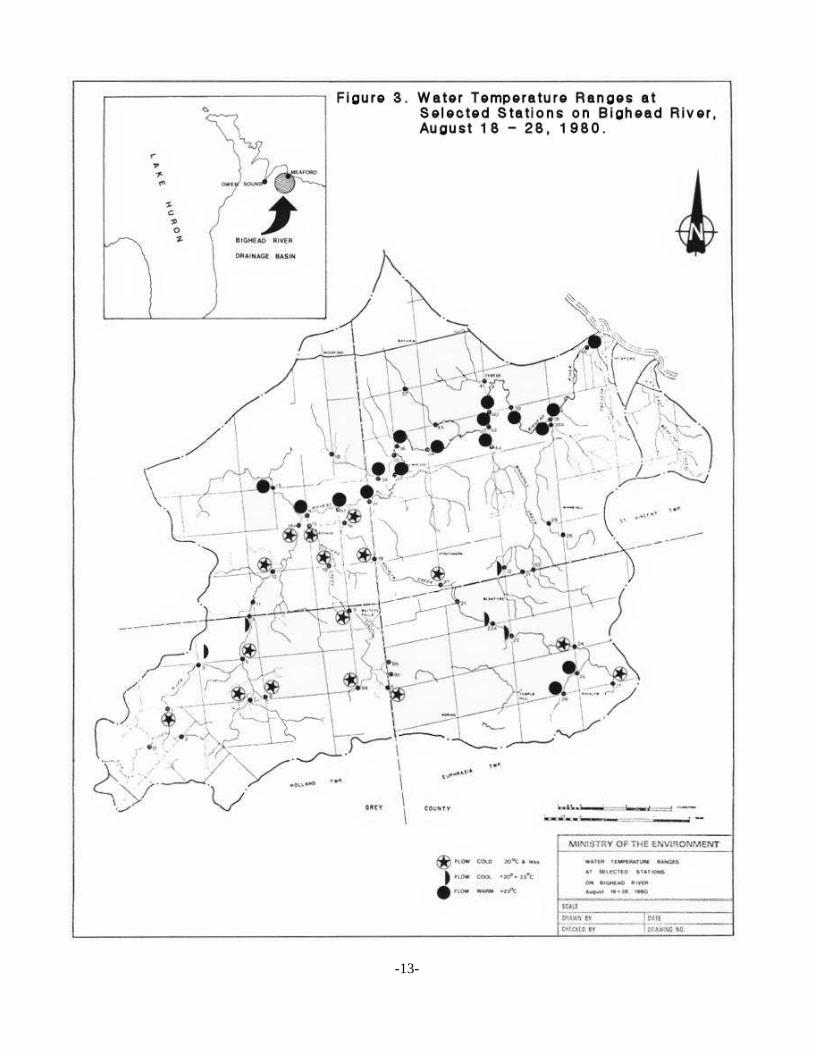
4.2 Water Temperatures
Figure 3 illustrates the average temperatures found during two 72 hour
temperature studies (August 18-28). In general, Rocklyn Creek, Walters Creek, plus
the headwater areas of the main Bighead, are cold water streams with some cool
areas.
The lower part of the watershed, which has fewer springs, less streambank cover
and greater agricultural development, has warmer water.
It is of interest to note that the section of Rocklyn Creek which was recently
ditched, apparently to facilitate drainage, is now a warm water stream as a result of
ditching.
Comparisons between the 1980 work and the work done in 1957 by the North
Grey Conservation Authority (1959 North Grey Conservation Authority Report), reveal
that certain sections of the watershed have changed from cold streams to warm
streams. These include the Bognor Marsh tributary, Minniehill Creek, Dunedin Creek,
and the channelized section of Rocklyn Creek.
Whether or not the Bighead remains a prime fishery stream will depend on the
maintenance of cold water in the Rocklyn Creek, Walters Creek and the main Bighead
River upstream from Bognor. Maintenance of the these cold water areas will depend
-12-
-13-
on the retention of stream side vegetation which provides shade and/or maintenance
of sensitive groundwater and discharge areas which continually cool the stream.
4.3 Suspended Solids
Water clarity is normally excellent and thus very few suspended solids analyses
were carried out. However, at most of the watershed sampling locations, at least one
measurement was made during turbid water conditions. At only three of the sampling
locations a concentration of greater than 500 mg/L was found. Two of these were on
the main river near the mouth, stations 42 and 48, and one near the mouth of
Minniehill Creek (station 43). A routine visual observation of the watershed confirmed
that Minnie-hill Creek, because of agricultural activities, is considerably affected by
erosion and turbidity.
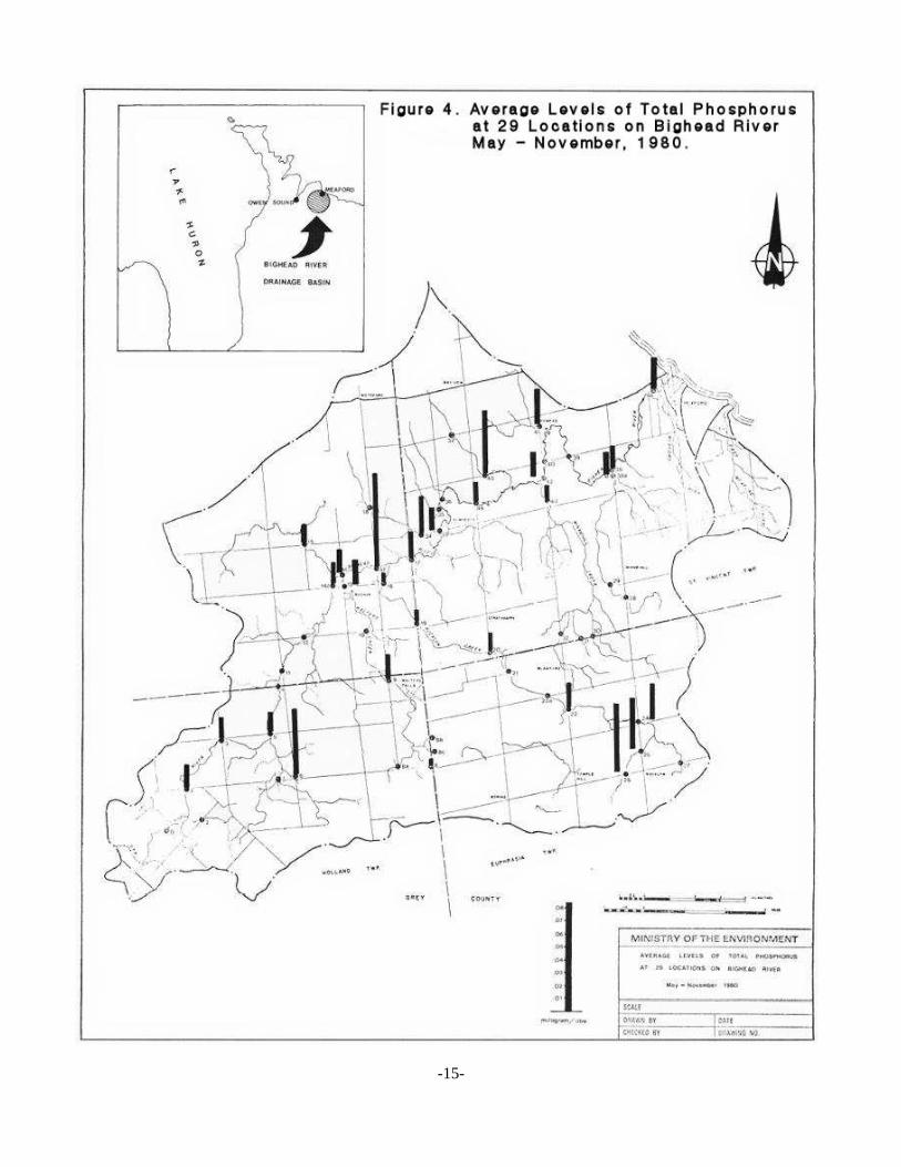
4.4 Phosphorus
In general, levels of phosphorus on the Bighead were very low. It would appear
that the background level of phosphorus in the watershed (i.e. without man's land use
disturbances) would be less than 0.010 mg/L. This background concentration is less
than a of this Ministry's objective of 0.030 mg/L.
Figure 4 illustrates that at those 29 locations where five or more samples were
collected; the Ministry's objective was exceeded at only five locations. At 5 of the 29
locations, the average concentration was less than 10 µg/L. At 17 locations the
average concentration was between 10 and 20 µg/L. Two of the five locations which
exceeded 30 µg/L were located on Rocklyn Drain; the recent channelization of the
drain has resulted in substantial elevation of phosphorus. A third location with
-14-
-15-
phosphorus above 30 µg/L was located in the upper reaches of the Bighead. (station
6) downstream from a fish hatchery. The fourth location (station 45) was located on
a small tributary entering the lower Bighead from the north. The reason for this being
elevated is not known. The fifth location (station 47) was located on the main stream
of the Bighead River near an intensive livestock production area.
4.5 Nitrogen
Levels of nitrogen are in general, favorably low in the watershed. The Kjeldahl,
nitrite and ammonia fractions are uniformly low throughout the whole watershed. The
raw data is tabulated in Appendix III.
Nitrate levels are illustrated in Figure 5. While most areas of the watershed had
average nitrate levels below 1 mg/L, a few stations had average values in the 2 to 3
mg/L range. These elevated values in some headwater areas no doubt reflect
discharges from surficial aquifers, which have been impacted somewhat from land use
activities (e.g. fertilizers, feedlot, subsurface disposal systems). The elevated
concentrations reveal the sensitivity of the surficial aquifer to contamination, at least.
in some areas of the watershed.
4.6 Other Chemical Parameters
No attempt is made in this report to interpret the remaining chemical
parameters which are less significant in evaluating the health of the river. However,
the data are outlined in the appendix for future reference and comparative purposes.
-16-

-17-
4.7 Storm Conditions
On July 15, nineteen locations were sampled (see Appendix III), during the
latter part of a major rainstorm when the river was in flood. A large majority of these
samples revealed greatly reduced water quality. Levels of phosphorus and suspended
solids, for example, were typically one or two orders of magnitude higher than those
under normal summer flow conditions. The location with the highest quality during the
storm was station #15, located on the tributary draining the Bognor Marsh. Unlike the
other sampling locations, stream quality downstream from the Bognor Marsh changed
little from low flow quality. This sample indicates the quality benefit of wetland
maintenance on the Bighead River. The wet weather data revealed that soil
conservation measures are needed on the Bighead watershed, even with the present
level of land use activities.
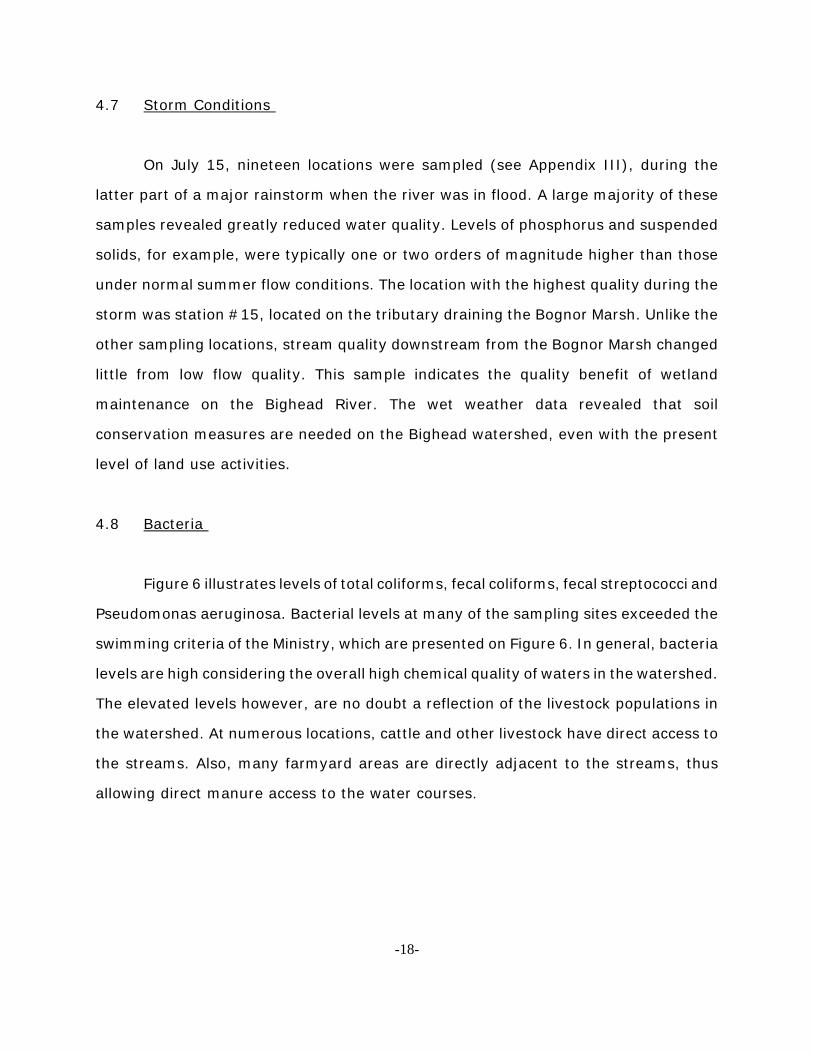
4.8 Bacteria
Figure 6 illustrates levels of total coliforms, fecal coliforms, fecal streptococci and
Pseudomonas aeruginosa. Bacterial levels at many of the sampling sites exceeded the
swimming criteria of the Ministry, which are presented on Figure 6. In general, bacteria
levels are high considering the overall high chemical quality of waters in the watershed.
The elevated levels however, are no doubt a reflection of the livestock populations in
the watershed. At numerous locations, cattle and other livestock have direct access to
the streams. Also, many farmyard areas are directly adjacent to the streams, thus
allowing direct manure access to the water courses.
-18-
-19-
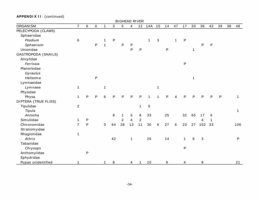
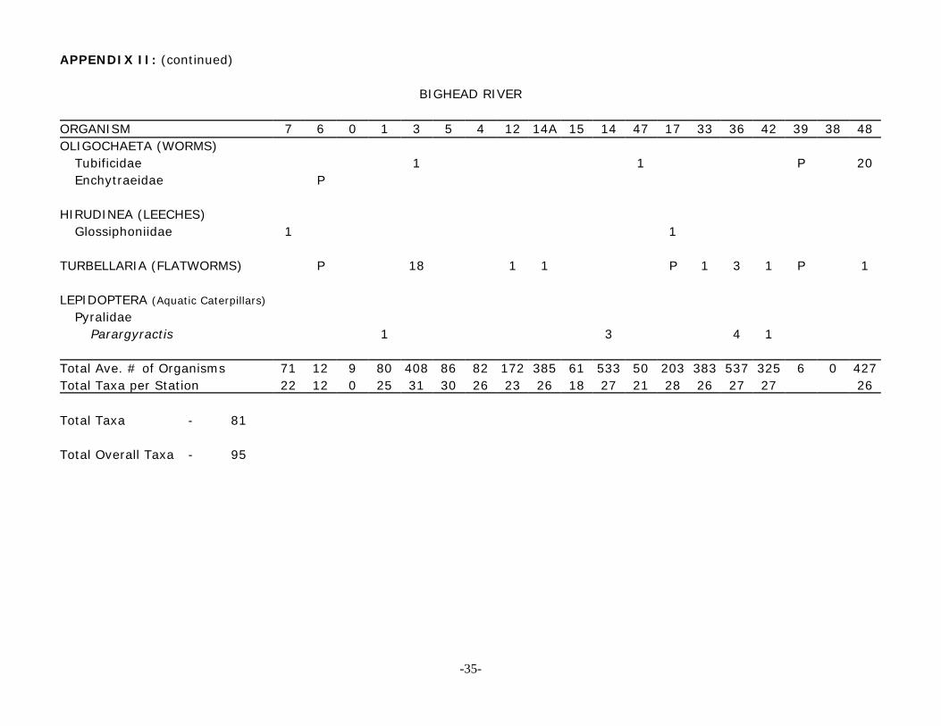
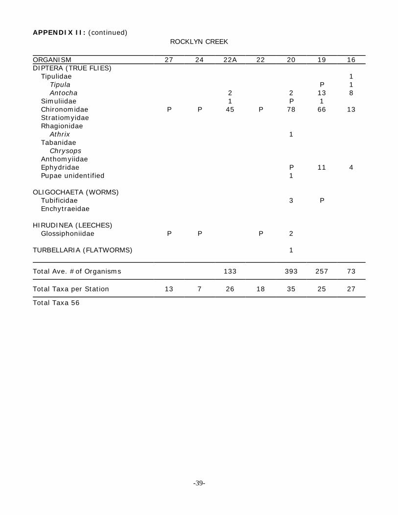
4.9 Bottom Fauna
The bottom fauna data are presented in Appendix II.
In general, the Bighead watershed supports an excellent benthic community.
The species diversity, community balance, and the biomass per unit area suggest an
excellent food base for game fish. There is a very large variety of insects, including
stoneflies, mayflies and caddisflies which serve as excellent fish food. The large variety
of invertebrates is a good indication of high water quality and ecological stability. At
many of the sampling locations, twenty to thirty different types of invertebrates were
found. The greatest variety of life (35 taxa) was found at station 20 on Rocklyn Creek.
5.0 AQUATIC VEGETATION
Growths of pondweed (Potamogeton spp.) were common in the even-flow
sections of the Bighead downstream from. Bognor. The growths were not excessive,
however. Growths of the filamentous green algae Cladophora were not common in the
Bighead River. However, significant growths were observed at stations 36 and 48, as
well as both sampling locations on the newly channelized section of Rocklyn Creek
(Stations 25 and 26).
Cladophora is a nuisance aquatic plant which grows profusely in nutrient-rich
streams and lakes. Nutrient levels in the Bighead are too low to support widespread
growth of this plant. As significant growths were found in the aforementioned sections
of the watershed, however, it is apparent that future nutrient levels must be kept at
or near the present concentrations. The growth of this troublesome algae in the future
will also depend on the extent to which the streams continue to be shaded by bank
vegetation.
-20-
6.0 GROUNDWATER
The Bighead River basin is divided into two major physiographic units. The first
unit is a limestone plain consisting of middle silurian dolomite overlain by a thin veneer
of overburden and in some cases would be considered sensitive to contamination from
surface activities due to its shallow nature. These conditions exist on the east and on
the west sides of the basin where the system is bounded by rock cliffs. The second
area is predominantly a drumlin till plain with thick (30 m+) glacial and lacustrine
deposits of ordovician and silurian shale carbonates. These conditions exist within the
valley where the sides and floor are completely covered with drumlins.
The two hydrogeological zones (shallow water aquifer and deep water aquifer)
are very important to the water quality of the Bighead River. On the limestone plain,
most wells are completed to shallow depths within the dolomite bedrock. On the lower
till plain area, wells tap numerous sand and gravel aquifers in the overburden which
are protected from surface contaminants by overlying deposits of silt and clay.
A brief review of water well records for the basin shows no discernible change
in water quality in the thirty years of records. The records do not list shallow wells, the
most susceptible to problems. No major groundwater problems are known to exist
within the basin.
The modification of the watershed headwaters by projects such as Rocklyn Creek
drainage work, and the proposed large scale gravel extraction, is likely to have
negative impacts on both surface and groundwater. Large drainage projects lower
water levels in the shallow water aquifers (wetland areas), shorten the duration and
increase the height of flood peaks, and significantly reduce base flow to streams from
the areas drained. The removal of large deposits of aggregates from the watershed has
-21-

similar effects, but also reduces the amount of natural treatment of groundwater
provided by these media.
-22-

APPENDIX I
-23-

BIGHEAD RIVER NEAR MEAFORD
1957-80 Period of Record 293 Sq. Km. Drainage Area.
JAN FEB MAR APR MAY JUN JULY AUG SEPT OCT NOV DECAverage Mean Monthly Flow 4.35 4.40 9.99 12.6 4.76 2.07 1.54 1.11 1.23 2.00 3.95 5.40Average Minimum MeanMonthly Flow with aRecurrence Interval2 Years 4.18 3.8 8.8 12.5 4.70 1.82 0.96 0.90 0.98 1.4 3.4 4.9
Average Minimum MeanMonthly Flow with aRecurrence Interval of5 Years 2.29 2.55 5.7 7.3 3.10 1.19 0.79 0.60 0.56 0.72 1.68 2.7
Average Minimum MeanMonthly Flow with aRecurrence Interval of10 Years 1.82 2.15 3.8 6.6 2.06 0.95 0.62 0.50 0.46 0.59 1.05 1.95
Average Minimum MeanMonthly Flow with aRecurrence Interval of20 Years 1.62 1.8 2.2 5.0 1.85 0.83 0.45 0.44 0.40 0.52 0.68 1.56
NOTE: All flows in cm
-24-

Bighead River Flow Data May-October 1980 Summary of 30 selected streamflow sites
Station Date cm cfs RemarksSta 0 Aug 12 -- Bighead tributary unable to gauge (low flow)Sta 1 May 20 0.541 19.1 Bighead River
June 16 0.184 6.5Aug 11 0.159 5.6Aug 12 0.159 5.6Aug 27 0.127 4.5Oct 1 0.159 5.6
Sta 5 Aug 12 0.515 18.2 Bighead RiverAug 27 0.334 11.8
Sta 6 Aug 12 0.085 3.0 Bighead tributaryAug 25 0.051 1.8
Sta 7 Aug 12 0.133 4.7 Bighead tributaryAug 25 0.136 4.8 (flow combination of Sta 52+7)
Sta 9 Aug 12 0.677 23.9 Walters CreekAug 25 0.886 31.3
Sta 13 May 20 1.441 50.9 Walters CreekJune 16 0.773 27.3 Aug 11 0.946 33.4 Aug 25 0.150 5.3Oct 1 0.623 22.2
Sta 14 May 20 2.084 73.6 Bighead River nearJune 16 0.603 21.3 BognorAug 11 1.158 40.9 Aug 25 0.586 20.7 Oct 1 0.606 21.4
Sta 15 May 20 0.742 26.2 Bognor Marsh.June 16 0.079 2.8 branch of Bighead RiverJuly 15 0.232 8.2Aug 11 0.527 18.6 "downstream from"Aug 25 0.156 5.5 damOct 1 0.076 2.7
Sta 16 May 20 0.532 18.8 Rocklyn CreekJune 17 0.229 8.1July 14 0.156 5.5Aug 11 0.300 10.6 Aug 25 0.198 7.0Oct 1 0.209 7.4
-25-

Station Date cm cfs RemarksSta 19 Aug 12 0.317 11.2 Rocklyn Creek
Aug 25 0.195 6.9Sta 20 Aug 12 0.289 10.2 Rocklyn Creek
Aug 25 0.147 5.2 (at north bridge)Sta 20 Aug 12 0.057 2.0 Rocklyn Creek
Aug 25 0.037 1.3 (at south bridge)Sta 24 Aug 12 0.167 5.9 Rocklyn Creek
Aug 25 0.091 3.2Sta 25 Aug 12 0.037 1.3 Rocklyn CreekSta 26 Aug 12 0.025 0.9 Rocklyn Creek
Sta 27 Aug 12 -- - -Rocklyn Creek unable to gauge (wet land area)
Sta 32 Aug 25 0.051 1.8 Minniehill CreekSta 34 July 14 - - Bighead tributary
Aug 11 0.244 8.6 Unable to gaugeAug 27 0.167 0.8 July 14 (low flow)Oct 1 0.167 5.9
Sta 38a May 21 0.113 4.0 Dunedin CreekJune 17 -- - - Unable to gaugeJuly 14 -- -- (low flow)Aug 14 0.045 0.5Aug 25 0.014 0.5Oct 1 0.020 0.7
Sta 41 Aug 12 0.006 0.2 Bighead tributaryAug 25 -- -- Unable to gauge (low flow)
Sta 42 Aug 12 2.577 91.0 Bighead RiverAug 25 1.390 49.1 Federal Gauge Site 02FB010
Sta 43 May 21 0.218 7.7 Minniehill CreekJune 17 0.105 3.7July 14 0.065 2.3Aug 11 0.229 8.1Aug 25 0.093 3.3Oct 1 0.105 3.7
Sta 45 May 21 0.127 4.5 Bighead tributaryJune 17 0.008 0.3July 14 - - - - Unable to gauge (low flow)Aug 11 0.079 2.8Aug 27 0.008 0.3Oct 1 0.008 0.3
-26-

Station Date cm cfs RemarksSta 46 Aug 13 -- -- Bighead tributary
Aug 27 -- -- unable to gauge (low flow)Sta 49 Aug 13 0.059 2.1 Bighead tributary
Sta 50 Aug 12 -- --Bighead tributaryunable to gauge (low flow)
Sta 52 Aug 12 0.054 1.9 Bighead tributarySta 53 Aug 14 0.133 4.0 Minniehill Creek
Aug 25 0.074 2.6Sta 54 Aug 14 0.051 1.8 Dunedin Creek
Aug 25 0.020 0.7Sta 55 Aug 14 -- - - Dunedin Creek
Aug 25 -- -- unable to gauge (low flow)
-27-
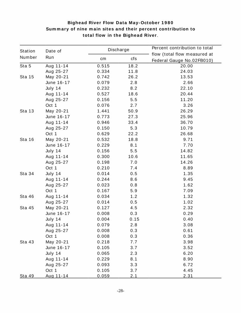
Bighead River Flow Data May-October 1980Summary of nine main sites and their percent contribution to
total flow in the Bighead River.
StationNumber
Date ofRun
Discharge Percent contribution to totalflow (total flow measured atFederal Gauge No.02FB010)cm cfs
Sta 5 Aug 11-14 0.515 18.2 20.00Aug 25-27 0.334 11.8 24.03
Sta 15 May 20-21 0.742 26.2 13.53June 16-17 0.079 2.8 2.66July 14 0.232 8.2 22.10Aug 11-14 0.527 18.6 20.44Aug 25-27 0.156 5.5 11.20Oct 1 0.076 2.7 3.26
Sta 13 May 20-21 1.441 50.9 26.29June 16-17 0.773 27.3 25.96Aug 11-14 0.946 33.4 36.70Aug 25-27 0.150 5.3 10.79Oct 1 0.629 22.2 26.68
Sta 16 May 20-21 0.532 18.8 9.71June 16-17 0.229 8.1 7.70July 14 0.156 5.5 14.82Aug 11-14 0.300 10.6 11.65Aug 25-27 0.198 7.0 14.26Oct 1 0.210 7.4 8.89
Sta 34 July 14 0.014 0.5 1.35Aug 11-14 0.244 8.6 9.45Aug 25-27 0.023 0.8 1.62Oct 1 0.167 5.9 7.09
Sta 46 Aug 11-14 0.034 1.2 1.32Aug 25-27 0.014 0.5 1.02
Sta 45 May 20-21 0.127 4.5 2.32June 16-17 0.008 0.3 0.29July 14 0.004 0.15 0.40Aug 11-14 0.079 2.8 3.08Aug 25-27 0.008 0.3 0.61Oct 1 0.008 0.3 0.36
Sta 43 May 20-21 0.218 7.7 3.98June 16-17 0.105 3.7 3.52July 14 0.065 2.3 6.20Aug 11-14 0.229 8.1 8.90Aug 25-27 0.093 3.3 6.72Oct 1 0.105 3.7 4.45
Sta 49 Aug 11-14 0.059 2.1 2.31
-28-

APPENDIX II
-29-
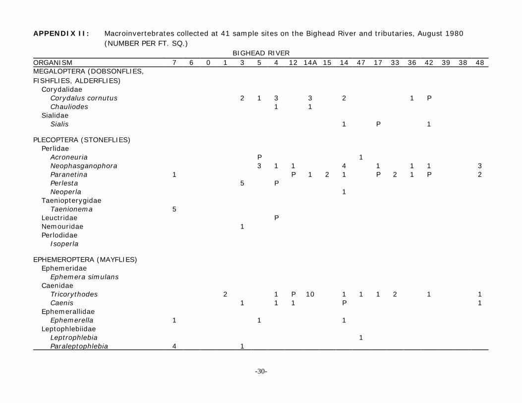
APPENDIX II: Macroinvertebrates collected at 41 sample sites on the Bighead River and tributaries, August 1980 (NUMBER PER FT. SQ.)
BIGHEAD RIVERORGANISM 7 6 0 1 3 5 4 12 14A 15 14 47 17 33 36 42 39 38 48MEGALOPTERA (DOBSONFLIES,FISHFLIES, ALDERFLIES)
CorydalidaeCorydalus cornutus 2 1 3 3 2 1 PChauliodes 1 1
SialidaeSialis 1 P 1
PLECOPTERA (STONEFLIES)Perlidae
Acroneuria P 1Neophasganophora 3 1 1 4 1 1 1 3Paranetina 1 P 1 2 1 P 2 1 P 2Perlesta 5 PNeoperla 1
TaeniopterygidaeTaenionema 5
Leuctridae PNemouridae 1Perlodidae
Isoperla
EPHEMEROPTERA (MAYFLIES)Ephemeridae
Ephemera simulansCaenidae
Tricorythodes 2 1 P 10 1 1 1 2 1 1Caenis 1 1 1 P 1
EphemerallidaeEphemerella 1 1 1
LeptophlebiidaeLeptrophlebia 1Paraleptophlebia 4 1
-30-
APPENDIX II: (continued)BIGHEAD RIVER
Organism 7 6 0 1 3 5 4 12 14A 15 14 47 17 33 36 42 39 38 48Baetidae
Isonychia P P P P 1 1 1 1 P P 1Baetis 8 P 1 40 10 8 13 4 1 15 3 2 19 19 24 86
HeptageniidaeStenonema 1 P 1 1 2 P 1 1 11S. tripunctatum 4 1 1S. fuscum 2 PS. nepotellum 1 1 1 2 4 1 4 1 2 3S. rubrum 1Stenacron P P 1 P 1 1 2 P 1
Unidentified 1
TRICHOPTERA (CADDISFLIES)Helicopsychidae
Helicopsyche 1 1Hydropsychidae
Hydropsyche 2 8 120 3 3 38 80 7 57 1 48 111 110 60 102Parapsyche PCheumatopsyche 1 9 3 1 1 14 20 14 43 25 50 43 32 31
HydroptilidaeHydroptila 16 1 1 6Agraylea 2Mayatrichia 2
LeptoceridaeOecetisNectopsyche
GlossosomatidaeGlossosoma 2 1 1 1
RhyacophilidaeRhyacophila 1 P 8 5 1
-31-

APPENDIX II: (continued)BIGHEAD RIVER
Organism 7 6 0 1 3 5 4 12 14A 15 14 47 17 33 36 42 39 38 48Philoptamidae
Chimarra 1 13 1 1 1 1 1 2Dolophilodes P
PolycentropodidaePolycentropus 1 P 1 P
PsychomyiidaePsychomyia 1 16 4 11
LepidostomatidaeLepidostoma 12 P
LimnephilidaeNeophylax 1 PHydatophylax 3 1 PPycnopsyche 1Hesperophylax PLimnephilusPsychoglypha
Pupae (unidentified) 5 P 18 14 2 1 2 3 P P 1 2
ODONATAZYGOPTERA (DAMSELFLIES)
Agrionidae 4 P P P P P P 2 P P PCoenagrioridae P P 1 3 P 1 P
ANISOPTERA (DRAGONFLIES)Aeshnidae P 2 P P PLibellulidae P P 1Cordulegastridae 2 1Gomphidae 1
COLEOPTERA (BEETLES)Dytiscidae
-32-
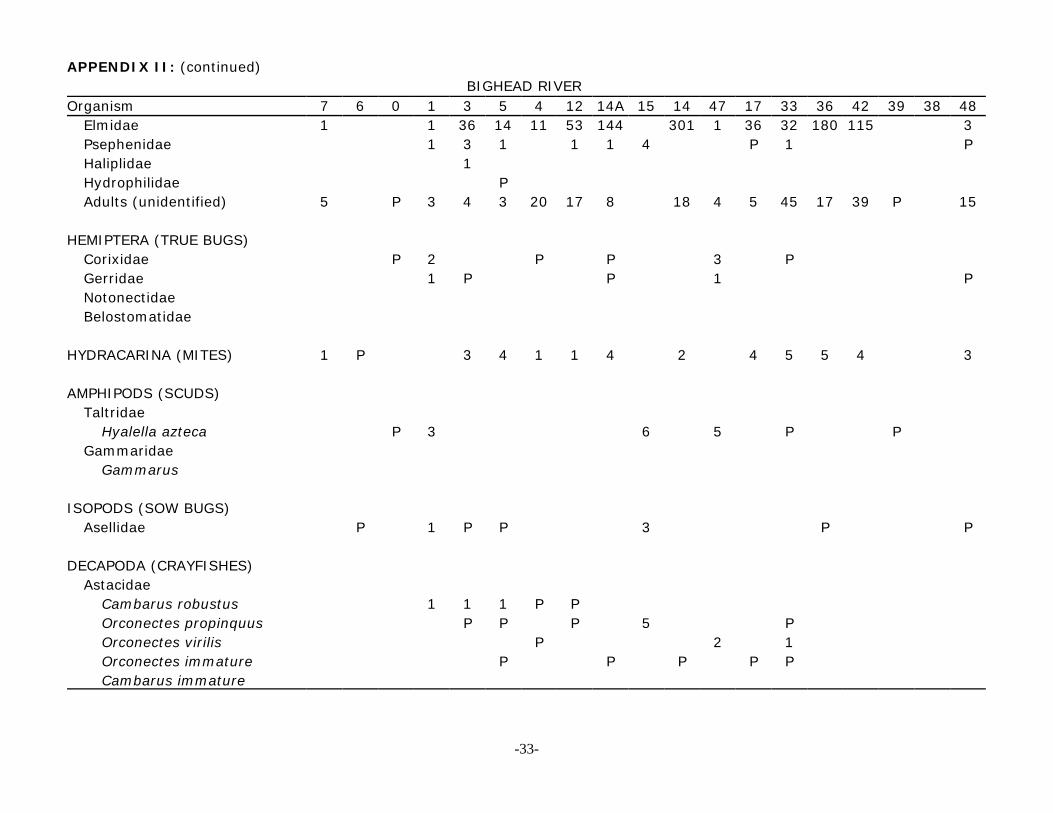
APPENDIX II: (continued)BIGHEAD RIVER
Organism 7 6 0 1 3 5 4 12 14A 15 14 47 17 33 36 42 39 38 48Elmidae 1 1 36 14 11 53 144 301 1 36 32 180 115 3Psephenidae 1 3 1 1 1 4 P 1 PHaliplidae 1Hydrophilidae PAdults (unidentified) 5 P 3 4 3 20 17 8 18 4 5 45 17 39 P 15
HEMIPTERA (TRUE BUGS)Corixidae P 2 P P 3 PGerridae 1 P P 1 PNotonectidaeBelostomatidae
HYDRACARINA (MITES) 1 P 3 4 1 1 4 2 4 5 5 4 3
AMPHIPODS (SCUDS)Taltridae
Hyalella azteca P 3 6 5 P PGammaridae
Gammarus
ISOPODS (SOW BUGS)Asellidae P 1 P P 3 P P
DECAPODA (CRAYFISHES)Astacidae
Cambarus robustus 1 1 1 P POrconectes propinquus P P P 5 POrconectes virilis P 2 1Orconectes immature P P P P PCambarus immature
-33-
APPENDIX II: (continued)BIGHEAD RIVER
ORGANISM 7 6 0 1 3 5 4 12 14A 15 14 47 17 33 36 42 39 38 48PELECYPODA (CLAMS)
SphaeriidaePisidium 6 1 P 1 3 1 PSphaerium P 1 P P P P
Unionidae P P P 1GASTROPODA (SNAILS)
AncylidaeFerrissia P
PlanorbidaeGyraulusHelisoma P 1
LymnaeidaeLymnaea 1 1 1
PhysidaePhysa 1 P P 6 P P P P 1 1 P 4 P P P P P 1
DIPTERA (TRUE FLIES)Tipulidae 2 1 5
Tipula 1Antocha 8 1 5 8 33 25 32 65 17 6
Simuliidae 1 P 2 4 2 4 1Chironomidae 7 P 3 64 28 13 11 30 6 27 6 23 27 102 33 106StratiomyidaeRhagionidae 1
Athrix 42 1 26 14 1 6 3 PTabanidae
Chrysops PAnthomyiidae PEphydridaePupae unidentified 1 1 8 4 1 10 9 4 9 21
-34-
APPENDIX II: (continued)
BIGHEAD RIVER
ORGANISM 7 6 0 1 3 5 4 12 14A 15 14 47 17 33 36 42 39 38 48OLIGOCHAETA (WORMS)
Tubificidae 1 1 P 20Enchytraeidae P
HIRUDINEA (LEECHES)Glossiphoniidae 1 1
TURBELLARIA (FLATWORMS) P 18 1 1 P 1 3 1 P 1
LEPIDOPTERA (Aquatic Caterpillars)Pyralidae
Parargyractis 1 3 4 1
Total Ave. # of Organisms 71 12 9 80 408 86 82 172 385 61 533 50 203 383 537 325 6 0 427Total Taxa per Station 22 12 0 25 31 30 26 23 26 18 27 21 28 26 27 27 26
Total Taxa - 81
Total Overall Taxa - 95
-35-
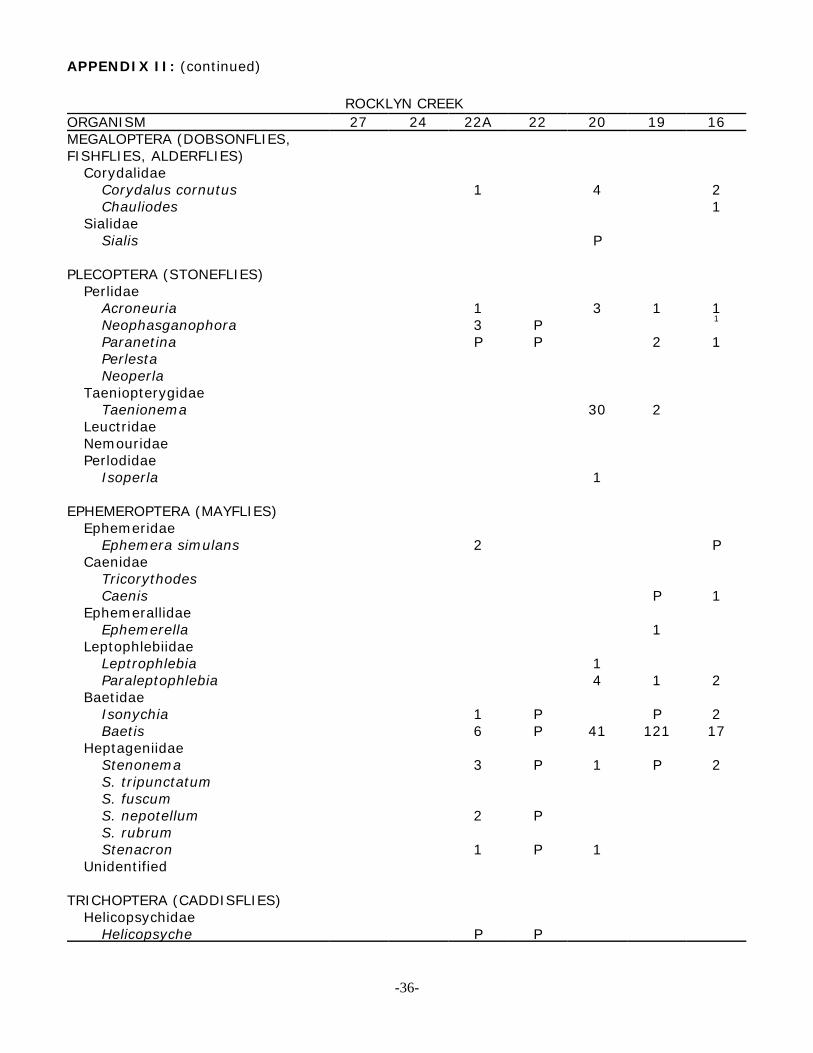
APPENDIX II: (continued)
ROCKLYN CREEK ORGANISM 27 24 22A 22 20 19 16MEGALOPTERA (DOBSONFLIES,FISHFLIES, ALDERFLIES)
CorydalidaeCorydalus cornutus 1 4 2Chauliodes 1
SialidaeSialis P
PLECOPTERA (STONEFLIES)Perlidae
Acroneuria 1 3 1 1Neophasganophora 3 P 1
Paranetina P P 2 1PerlestaNeoperla
TaeniopterygidaeTaenionema 30 2
LeuctridaeNemouridaePerlodidae
Isoperla 1
EPHEMEROPTERA (MAYFLIES)Ephemeridae
Ephemera simulans 2 PCaenidae
TricorythodesCaenis P 1
EphemerallidaeEphemerella 1
LeptophlebiidaeLeptrophlebia 1Paraleptophlebia 4 1 2
BaetidaeIsonychia 1 P P 2Baetis 6 P 41 121 17
HeptageniidaeStenonema 3 P 1 P 2S. tripunctatumS. fuscumS. nepotellum 2 PS. rubrumStenacron 1 P 1
Unidentified
TRICHOPTERA (CADDISFLIES)Helicopsychidae
Helicopsyche P P
-36-

APPENDIX II: (continued)ROCKLYN CREEK
ORGANISM 27 24 22A 22 20 19 16Hydropsychidae
Hydropsyche 30 P 37 3ParapsycheCheumatopsyche P P 13 P 15 8 1
HydroptilidaeHydroptila 2 15 1AgrayleaMayatrichia
LeptoceridaeOecetis 1Nectopsyche
GlossosomatidaeGlossosoma 1 1
RhyacophilidaeRhyacophila 4 3 3
PhiloptamidaeChimarra 2 PDolophilodes 37 4
PolycentropodidaePolycentropus P 9 1
PsychomyiidaePsychomyia
LepidostomatidaeLepidostoma
LimnephilidaeNeophylaxHydatophylax 2 PPycnopsycheHesperophylax PLimnephilus P p PPsychoglypha 2
Pupae (unidentified) P 7 1 2
ODONATAZYGOPTERA (DAMSELFLIES)
Agrionidae P P P PCoenagrioridae P
ANISOPTERA (DRAGONFLIES)AeshnidaeLibellulidaeCordulegastridaeGomphidae
COLEOPTERA (BEETLES)DytiscidaeElmidae 1 112 4 2Psephenidae 3 P 2 2
-37-
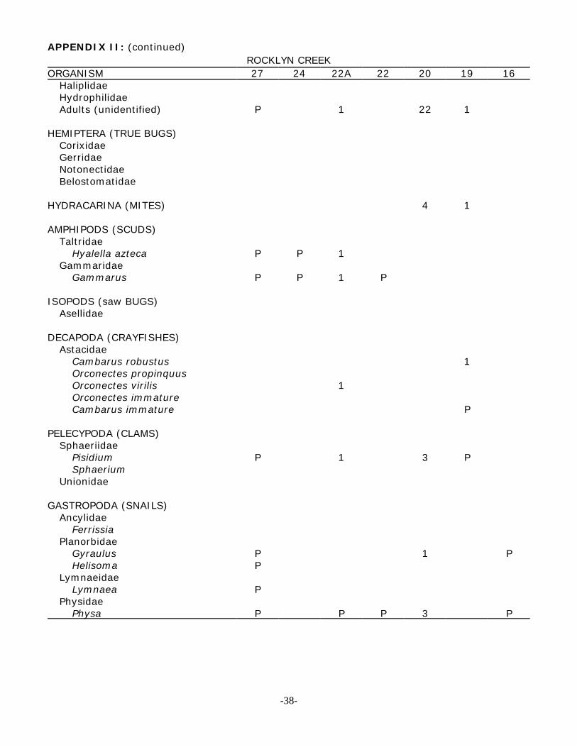
APPENDIX II: (continued)ROCKLYN CREEK
ORGANISM 27 24 22A 22 20 19 16HaliplidaeHydrophilidaeAdults (unidentified) P 1 22 1
HEMIPTERA (TRUE BUGS)CorixidaeGerridaeNotonectidaeBelostomatidae
HYDRACARINA (MITES) 4 1
AMPHIPODS (SCUDS)Taltridae
Hyalella azteca P P 1Gammaridae
Gammarus P P 1 P
ISOPODS (saw BUGS)Asellidae
DECAPODA (CRAYFISHES)Astacidae
Cambarus robustus 1Orconectes propinquusOrconectes virilis 1Orconectes immatureCambarus immature P
PELECYPODA (CLAMS)Sphaeriidae
Pisidium P 1 3 PSphaerium
Unionidae
GASTROPODA (SNAILS)Ancylidae
FerrissiaPlanorbidae
Gyraulus P 1 PHelisoma P
LymnaeidaeLymnaea P
PhysidaePhysa P P P 3 P
-38-
APPENDIX II: (continued)ROCKLYN CREEK
ORGANISM 27 24 22A 22 20 19 16DIPTERA (TRUE FLIES)
Tipulidae 1Tipula P 1Antocha 2 2 13 8
Simuliidae 1 P 1Chironomidae P P 45 P 78 66 13StratiomyidaeRhagionidae
Athrix 1Tabanidae
ChrysopsAnthomyiidaeEphydridae P 11 4Pupae unidentified 1
OLIGOCHAETA (WORMS)Tubificidae 3 PEnchytraeidae
HIRUDINEA (LEECHES)Glossiphoniidae P P P 2
TURBELLARIA (FLATWORMS) 1
Total Ave. #of Organisms 133 393 257 73
Total Taxa per Station 13 7 26 18 35 25 27
Total Taxa 56
-39-
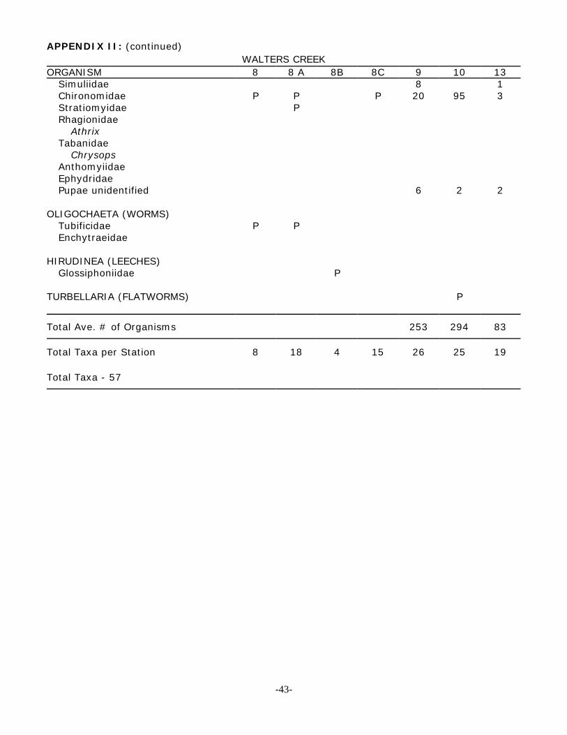
APPENDIX II: (continued)WALTERS CREEK
ORGANISM 8 8A 8B 8C 9 10 13MEGALOPTERA (DOBSONFLIES,FISHFLIES, ALDERFLIES)
CorydalidaeCorydalus cornutus P 2 1 pChauliodes
SialidaeSialis P
PLECOPTERA (STONEFLIES)Perlidae
Acroneuria P 2Neophasganophora P 3 2Paranetina 1 1 5PerlestaNeoperla
TaeniopterygidaeTaenionema P 4 1 2
LeuctridaeNemouridae P PPerlodidae
Isoperla
EPHEMEROPTERA (MAYFLIES)Ephemeridae
Ephemera simulansCaenidae
TricorythodesCaenis 4 1 1
EphemerallidaeEphemerella P 5
LeptophlebiidaeLeptrophlebiaParaleptophlebia P P 1 3 P
BaetidaeIsonychiaBaetis P P 105 94 26
HeptageniidaeStenonema 2S. tripunctatumS. fuscum P 2S. nepotellum 2S. rubrumStenacron
Unidentified
TRICHOPTERA (CADDISFLIES)Helicopsychidae
Helicopsyche 1 1
-40-
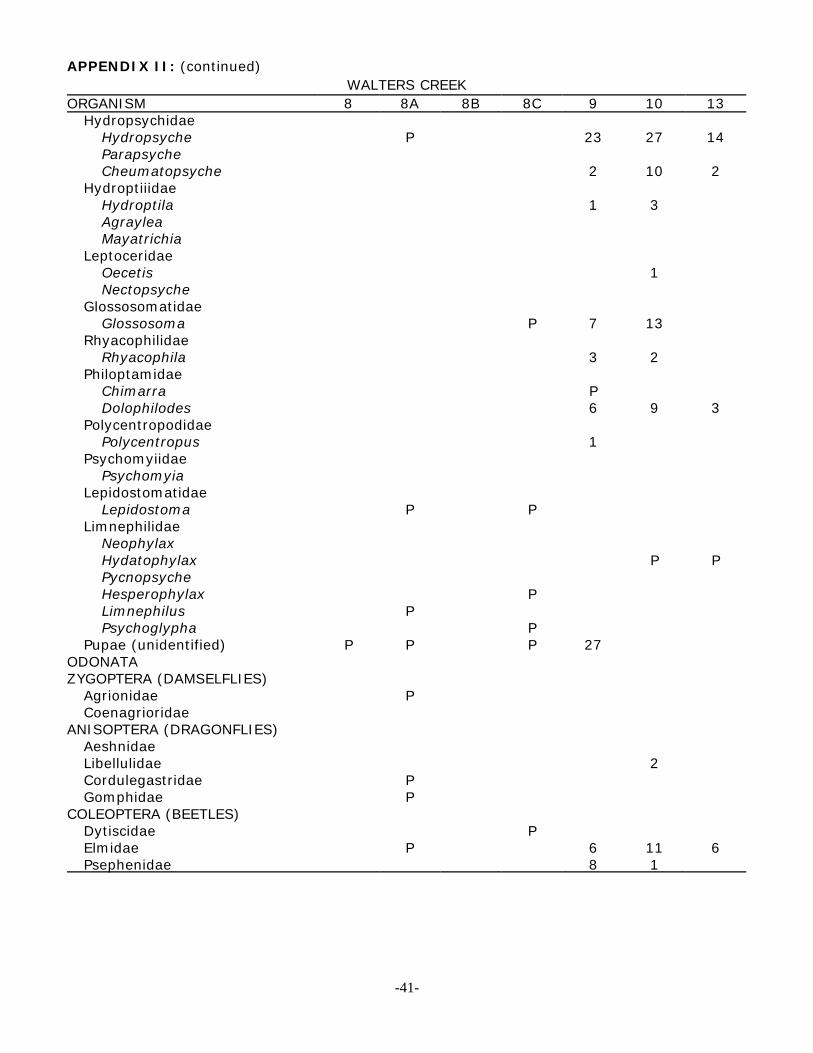
APPENDIX II: (continued)WALTERS CREEK
ORGANISM 8 8A 8B 8C 9 10 13Hydropsychidae
Hydropsyche P 23 27 14ParapsycheCheumatopsyche 2 10 2
HydroptiiidaeHydroptila 1 3AgrayleaMayatrichia
LeptoceridaeOecetis 1Nectopsyche
GlossosomatidaeGlossosoma P 7 13
RhyacophilidaeRhyacophila 3 2
PhiloptamidaeChimarra PDolophilodes 6 9 3
PolycentropodidaePolycentropus 1
PsychomyiidaePsychomyia
LepidostomatidaeLepidostoma P P
LimnephilidaeNeophylaxHydatophylax P PPycnopsycheHesperophylax PLimnephilus PPsychoglypha P
Pupae (unidentified) P P P 27ODONATAZYGOPTERA (DAMSELFLIES)
Agrionidae PCoenagrioridae
ANISOPTERA (DRAGONFLIES)AeshnidaeLibellulidae 2Cordulegastridae PGomphidae P
COLEOPTERA (BEETLES)Dytiscidae PElmidae P 6 11 6Psephenidae 8 1
-41-
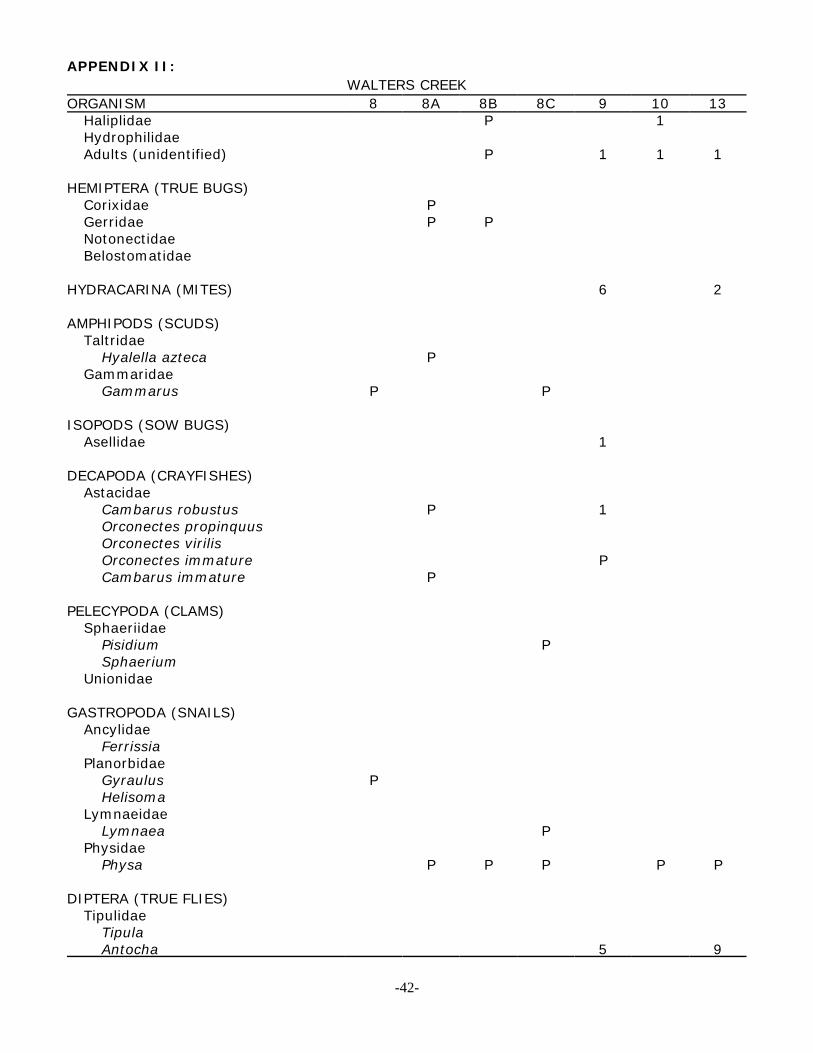
APPENDIX II:WALTERS CREEK
ORGANISM 8 8A 8B 8C 9 10 13Haliplidae P 1HydrophilidaeAdults (unidentified) P 1 1 1
HEMIPTERA (TRUE BUGS)Corixidae PGerridae P PNotonectidaeBelostomatidae
HYDRACARINA (MITES) 6 2
AMPHIPODS (SCUDS)Taltridae
Hyalella azteca PGammaridae
Gammarus P P
ISOPODS (SOW BUGS)Asellidae 1
DECAPODA (CRAYFISHES)Astacidae
Cambarus robustus P 1Orconectes propinquusOrconectes virilisOrconectes immature PCambarus immature P
PELECYPODA (CLAMS)Sphaeriidae
Pisidium PSphaerium
Unionidae
GASTROPODA (SNAILS)Ancylidae
FerrissiaPlanorbidae
Gyraulus PHelisoma
LymnaeidaeLymnaea P
PhysidaePhysa P P P P P
DIPTERA (TRUE FLIES)Tipulidae
TipulaAntocha 5 9
-42-
APPENDIX II: (continued)WALTERS CREEK
ORGANISM 8 8 A 8B 8C 9 10 13Simuliidae 8 1Chironomidae P P P 20 95 3Stratiomyidae PRhagionidae
AthrixTabanidae
ChrysopsAnthomyiidaeEphydridaePupae unidentified 6 2 2
OLIGOCHAETA (WORMS)Tubificidae P PEnchytraeidae
HIRUDINEA (LEECHES)Glossiphoniidae P
TURBELLARIA (FLATWORMS) P
Total Ave. # of Organisms 253 294 83
Total Taxa per Station 8 18 4 15 26 25 19
Total Taxa - 57
-43-
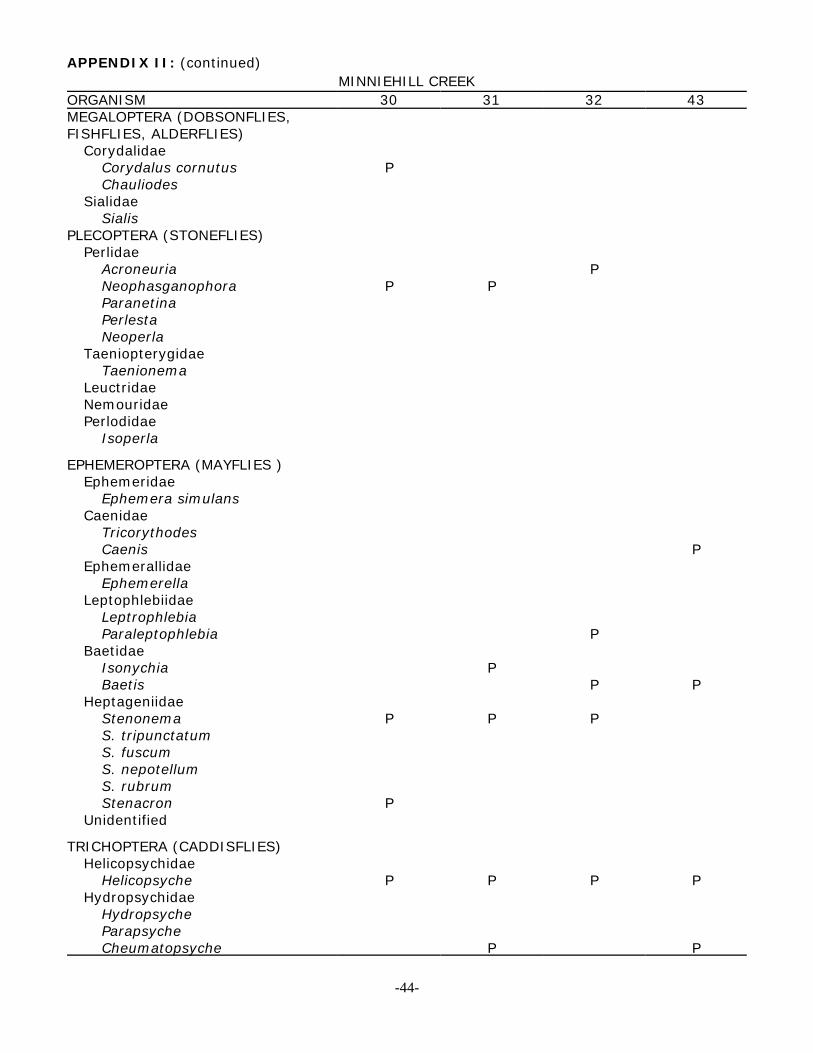
APPENDIX II: (continued)MINNIEHILL CREEK
ORGANISM 30 31 32 43MEGALOPTERA (DOBSONFLIES,FISHFLIES, ALDERFLIES)
CorydalidaeCorydalus cornutus PChauliodes
SialidaeSialis
PLECOPTERA (STONEFLIES)Perlidae
Acroneuria PNeophasganophora P PParanetinaPerlestaNeoperla
TaeniopterygidaeTaenionema
LeuctridaeNemouridaePerlodidae
Isoperla
EPHEMEROPTERA (MAYFLIES )Ephemeridae
Ephemera simulansCaenidae
TricorythodesCaenis P
EphemerallidaeEphemerella
LeptophlebiidaeLeptrophlebiaParaleptophlebia P
BaetidaeIsonychia PBaetis P P
HeptageniidaeStenonema P P PS. tripunctatumS. fuscumS. nepotellumS. rubrumStenacron P
Unidentified
TRICHOPTERA (CADDISFLIES)Helicopsychidae
Helicopsyche P P P PHydropsychidae
HydropsycheParapsycheCheumatopsyche P P
-44-
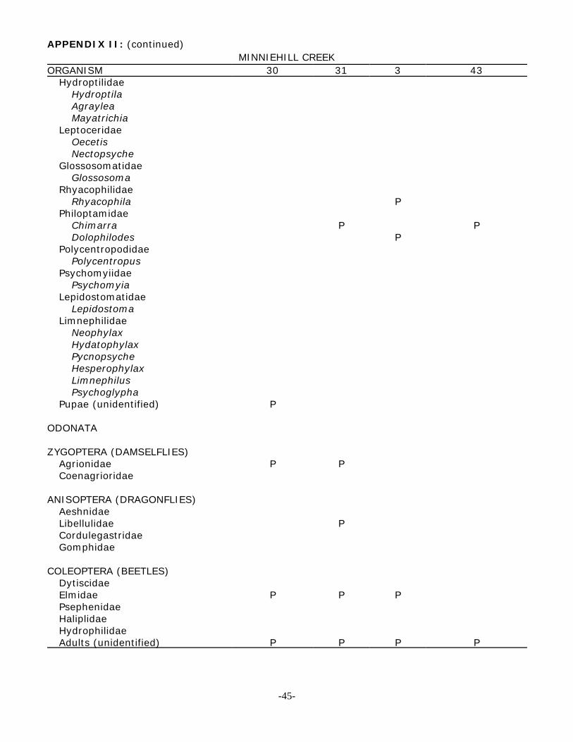
APPENDIX II: (continued)MINNIEHILL CREEK
ORGANISM 30 31 3 43Hydroptilidae
HydroptilaAgrayleaMayatrichia
LeptoceridaeOecetisNectopsyche
GlossosomatidaeGlossosoma
RhyacophilidaeRhyacophila P
PhiloptamidaeChimarra P PDolophilodes P
PolycentropodidaePolycentropus
PsychomyiidaePsychomyia
LepidostomatidaeLepidostoma
LimnephilidaeNeophylaxHydatophylaxPycnopsycheHesperophylaxLimnephilusPsychoglypha
Pupae (unidentified) P
ODONATA
ZYGOPTERA (DAMSELFLIES)Agrionidae P PCoenagrioridae
ANISOPTERA (DRAGONFLIES)AeshnidaeLibellulidae PCordulegastridaeGomphidae
COLEOPTERA (BEETLES)DytiscidaeElmidae P P PPsephenidaeHaliplidaeHydrophilidaeAdults (unidentified) P P P P
-45-
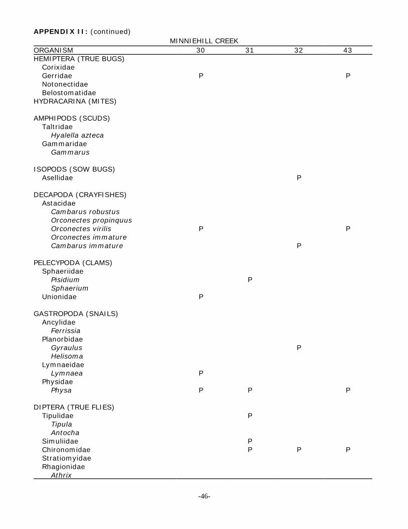
APPENDIX II: (continued)MINNIEHILL CREEK
ORGANISM 30 31 32 43HEMIPTERA (TRUE BUGS)
CorixidaeGerridae P PNotonectidaeBelostomatidae
HYDRACARINA (MITES)
AMPHIPODS (SCUDS)Taltridae
Hyalella aztecaGammaridae
Gammarus
ISOPODS (SOW BUGS)Asellidae P
DECAPODA (CRAYFISHES)Astacidae
Cambarus robustusOrconectes propinquusOrconectes virilis P POrconectes immatureCambarus immature P
PELECYPODA (CLAMS)Sphaeriidae
Pisidium PSphaerium
Unionidae P
GASTROPODA (SNAILS)Ancylidae
FerrissiaPlanorbidae
Gyraulus PHelisoma
LymnaeidaeLymnaea P
PhysidaePhysa P P P
DIPTERA (TRUE FLIES)Tipulidae P
TipulaAntocha
Simuliidae PChironomidae P P PStratiomyidaeRhagionidae
Athrix
-46-

APPENDIX II: (continued)
MINNIEHILL CREEK
ORGANISM 30 31 32 43Tabanidae
ChrysopsAnthomyiidaeEphydridaePupae unidentified P
OLIGOCHAETA (WORMS)Tubificidae PEnchytraeidae
HIRUDINEA (LEECHES)Glossiphoniidae
TURBELLARIA (FLATWORMS) P
Total Taxa per Station 12 15 12 11
Total Taxa - 30
-47-

APPENDIX II: (continued)OTHER TRIBUTARIES OF THE BIGHEAD RIVER
ORGANISM 34 35 41 45MEGALOPTERA (DOBSONFLIES,FISHFLIES, ALDERFLIES)
CorydalidaeCorydalus cornutusChauliodes
SialidaeSialis
PLECOPTERA (STONEFLIES)Perlidae
AcroneuriaNeophasganophoraParanetinaPerlestaNeoperla
TaeniopterygidaeTaenionema
LeuctridaeNemouridaePerlodidae
Isoperla
EPHEMEROPTERA (MAYFLIES)Ephemeridae
Ephemera simulansCaenidae
TricorythodesCaenis
EphemerallidaeEphemerella
LeptophlebiidaeLeptrophlebiaParaleptophlebia
BaetidaeIsonychiaBaetis P 1
HeptageniidaeStenonemaS. tripunctatum P PS. fuscumS. nepotellumS. rubrumStenacronUnidentified
TRICHOPTERA (CADDISFLIES)Helicopsychidae
Helicopsyche
-48-
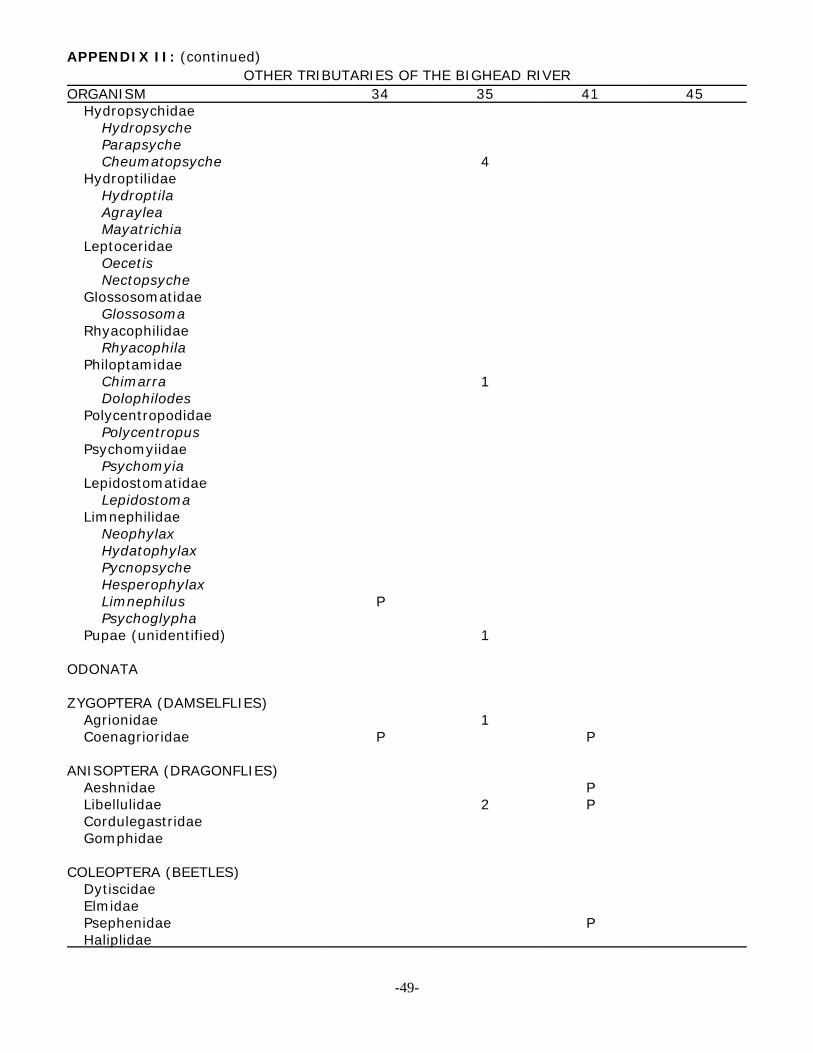
APPENDIX II: (continued)OTHER TRIBUTARIES OF THE BIGHEAD RIVER
ORGANISM 34 35 41 45Hydropsychidae
HydropsycheParapsycheCheumatopsyche 4
HydroptilidaeHydroptilaAgrayleaMayatrichia
LeptoceridaeOecetisNectopsyche
GlossosomatidaeGlossosoma
RhyacophilidaeRhyacophila
PhiloptamidaeChimarra 1Dolophilodes
PolycentropodidaePolycentropus
PsychomyiidaePsychomyia
LepidostomatidaeLepidostoma
LimnephilidaeNeophylaxHydatophylaxPycnopsycheHesperophylaxLimnephilus PPsychoglypha
Pupae (unidentified) 1
ODONATA
ZYGOPTERA (DAMSELFLIES)Agrionidae 1Coenagrioridae P P
ANISOPTERA (DRAGONFLIES)Aeshnidae PLibellulidae 2 PCordulegastridaeGomphidae
COLEOPTERA (BEETLES)DytiscidaeElmidaePsephenidae PHaliplidae
-49-
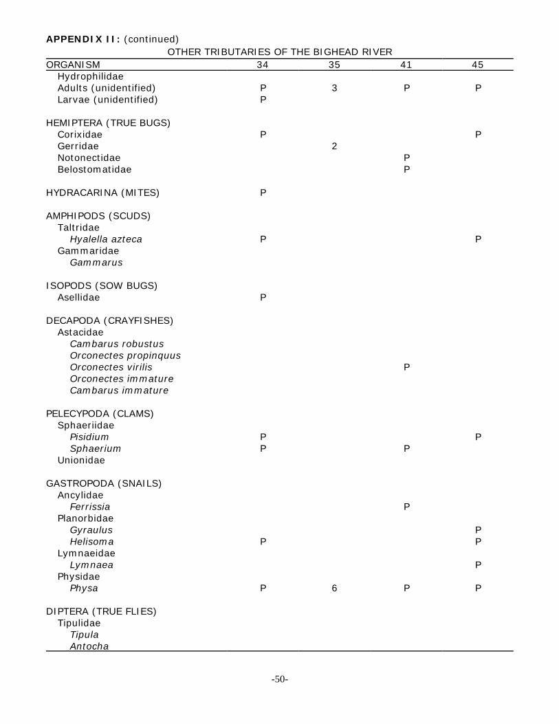
APPENDIX II: (continued)OTHER TRIBUTARIES OF THE BIGHEAD RIVER
ORGANISM 34 35 41 45HydrophilidaeAdults (unidentified) P 3 P PLarvae (unidentified) P
HEMIPTERA (TRUE BUGS)Corixidae P PGerridae 2Notonectidae PBelostomatidae P
HYDRACARINA (MITES) P
AMPHIPODS (SCUDS)Taltridae
Hyalella azteca P PGammaridae
Gammarus
ISOPODS (SOW BUGS)Asellidae P
DECAPODA (CRAYFISHES)Astacidae
Cambarus robustusOrconectes propinquusOrconectes virilis POrconectes immatureCambarus immature
PELECYPODA (CLAMS)Sphaeriidae
Pisidium P PSphaerium P P
Unionidae
GASTROPODA (SNAILS)Ancylidae
Ferrissia PPlanorbidae
Gyraulus PHelisoma P P
LymnaeidaeLymnaea P
PhysidaePhysa P 6 P P
DIPTERA (TRUE FLIES)Tipulidae
TipulaAntocha
-50-

APPENDIX II: (continued)OTHER TRIBUTARIES OF THE BIGHEAD RIVER
ORGANISM 34 35 41 45Simuliidae 2Chironomidae 1 P PStratiomyidaeRhagionidae
AthrixTabanidae
ChrysopsAnthomyiidaeEphydridaePupae unidentified
OLIGOCHAETA (WORMS)Tubificidae 1Enchytraeidae
HIRUDINEA (LEECHES)Glossiphoniidae
TURBELLARIA (FLATWORMS) P
Total Average # of Organisms 26
Total Taxa 14 11 12 10
-51-

APPENDIX III
-52-

-53-

-54-
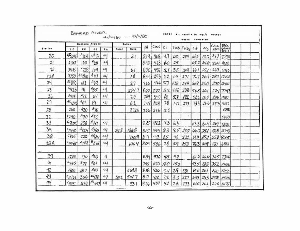
-55-
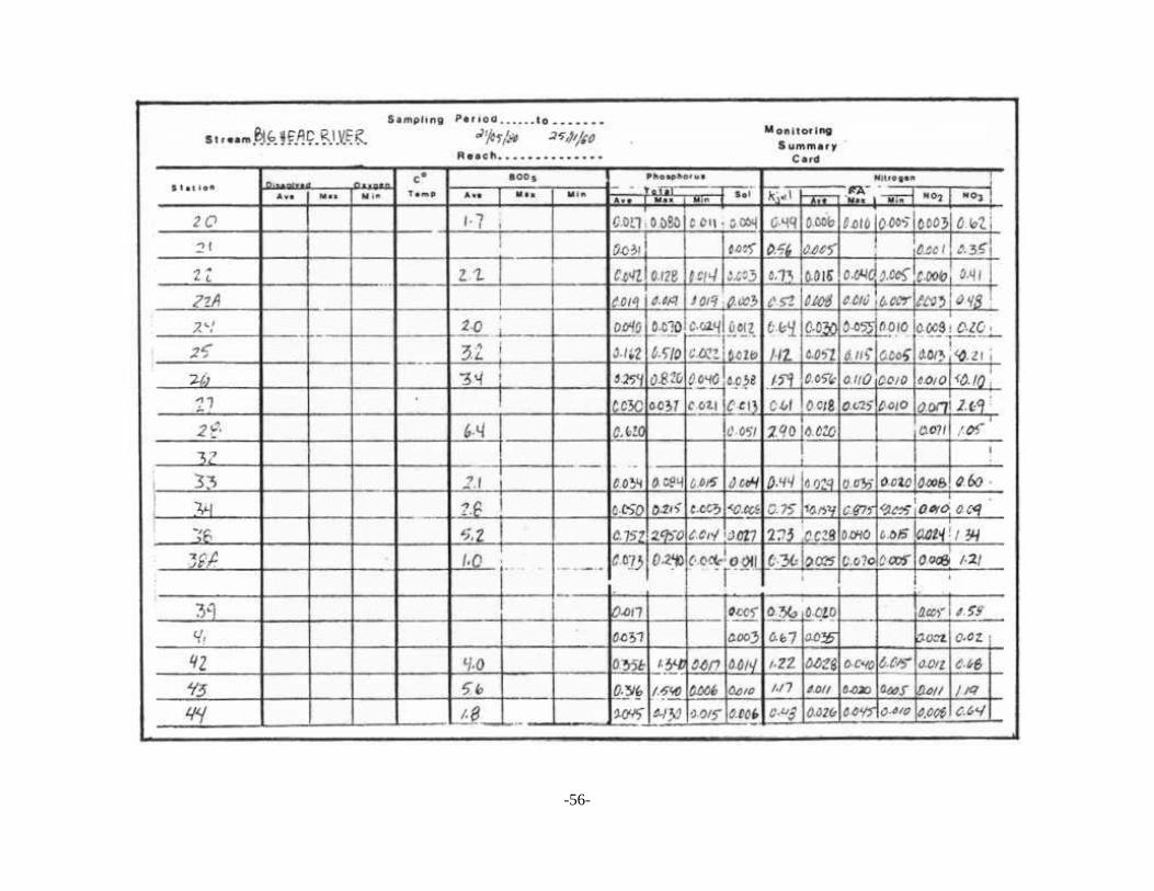
-56-
-57-

-58-