water quality assessment methoddeq.mt.gov/portals/112/water/wqpb/qaprogram/documents/pdf/sop… ·...
TRANSCRIPT

WQPBWQM-001
Water Quality Assessment Method
November 28, 2011 Prepared by: Water Quality Planning Bureau Montana Department of Environmental Quality 1520 E. Sixth Avenue P.O. Box 200901 Helena, MT 59620-0901

Suggested citation: Department of Environmental Quality, Water Quality Planning Bureau. 2011. Water Quality Assessment Method. Helena, MT: Montana Dept. of Environmental Quality.
REVISION HISTORY
RevisionNo.
Date Modified By Sections Modified
Description of Changes
3.0 June 2011
M. McCarthy All Major revision to provide a structured and consistent approach for assessing Montana’s waters. The most significant changes to the process are the incorporation of pollutant-specific methods to assess water quality and a specific process for evaluating data used for assessments.
4.0 Nov 2011
M. McCarthy All Minor revision in response to public comments. Temperature was removed as one of the pollutant groups. Tables were removed from Section 6.

Water Quality Assessment Method
11/28/11 FINAL i
TABLE OF CONTENTS Acronyms ..................................................................................................................................................... iii
Executive Summary ....................................................................................................................................... 1
1.0 Introduction ............................................................................................................................................ 2
1.1 Methods Overview .............................................................................................................................. 2
1.2 Evaluation Overview ........................................................................................................................... 2
2.0 Water Quality Standards ......................................................................................................................... 3
2.1 Beneficial Uses .................................................................................................................................... 3
2.2 Water Quality Criteria ......................................................................................................................... 5
2.2.1 Numeric Criteria ........................................................................................................................... 5
2.2.2 Narrative Criteria ......................................................................................................................... 5
2.3 Nondegradation .................................................................................................................................. 6
3.0 Identifying Available Water Quality Data ............................................................................................... 6
3.1 Minimum Data Requirements ............................................................................................................ 7
3.2 Data Quality Assessments ................................................................................................................... 7
4.0 Assessment Units .................................................................................................................................... 8
4.1 Managing the Assessment Record Data ............................................................................................. 8
5.0 Reporting the Status of Montana’s Water Quality ................................................................................. 9
5.1 Listing Categories for Surface Waters ................................................................................................. 9
5.2 Changing Reporting Categories ......................................................................................................... 10
5.3 Delisting from Category 5 ................................................................................................................. 10
6.0 Methods for Assessing Pollutant Groups .............................................................................................. 10
6.1 Metals ............................................................................................................................................... 11
6.2 Nutrients – Mountainous and Transitional Streams ......................................................................... 12
6.3 Nutrients – Prairie Streams ............................................................................................................... 12
6.4 Sediment ........................................................................................................................................... 13
7.0 Prioritizing TMDL Development for Listed Waters ............................................................................... 13
8.0 Bibliography .......................................................................................................................................... 14
Appendix A – Assessment Method Templates ........................................................................................... 17
Appendix B – Decision Matrices For Nutrients ........................................................................................... 22
LIST OF TABLES
Table 1-1. Beneficial Uses Described in Use Classification ........................................................................... 4

Water Quality Assessment Method
11/28/11 FINAL ii
Table 4-1. AUID Naming Convention ............................................................................................................ 8 Table 5-1. Integrated Report Federal Listing Categories .............................................................................. 9 Table 5-2. Delisting Process Used by Montana ........................................................................................... 10 Table A-1. Nutrients – Mountainous and Transitional Streams ................................................................. 17 Table A-2. Nutrients – Prairie Streams........................................................................................................ 18 Table A-3. Metals – Aquatic Life/Fishes (Cold and Warm Water) .............................................................. 19 Table A-4. Metals – Drinking Water ............................................................................................................ 20 Table A-5. Sedimentation/Siltation and Bedload Solids ............................................................................. 21 Table B-1. Nutrients – Mountain and Transitional Level I Decision Matrix ................................................ 22 Table B-2. Nutrients – Mountain and Transitional Level II Decision Matrix ............................................... 26 Table B-3. Nutrients – Plains Level I Decision Matrix.................................................................................. 29 Table B-4. Nutrients – Plains Level II Decision Matrix................................................................................. 33

Water Quality Assessment Method
11/28/11 FINAL iii
ACRONYMS
Acronym Definition AFDW Ash Free Dry Weight ARM Administrative Rules of Montana AU Assessment Unit BOD Biochemical Oxygen Demand CFL Cycle First Listed CFR Code of Federal Regulations CWA Clean Water Act DEQ Department of Environmental Quality (Montana) DO Dissolved Oxygen DQA Data Quality Assessment EPA Environmental Protection Agency (US) HBI Hilsenhoff Biotic Index MCA Montana Code Annotated MWQA Montana Water Quality Act NHD National Hydrography Data(set) QA Quality Assurance QAPP Quality Assurance Project Plan QC Quality Control RPD Residual Pool Depth RSI Riffle Stability Index SAP Sampling and Analysis Plan SCD Sufficient Credible Data TMDL Total Maximum Daily Load TN Total Nitrogen TP Total Phosphorus USGS United States Geological Survey WARD Water quality Assessment, Reporting, and Documentation system WQS Water Quality Standards

Water Quality Assessment Method
11/28/11 FINAL iv

Water Quality Assessment Method
11/28/11 FINAL 1
EXECUTIVE SUMMARY
This update of the Montana Department of Environmental Quality’s (DEQ) Water Quality Assessment Method includes a substantial change in the process. The ultimate goal is to provide a structured and consistent approach for assessing Montana’s waters. DEQ’s assessment method is built to the goals and concepts of Montana’s Water Quality Act and better aligns the assessment process with the water quality goals expressed in Montana’s water quality standards. At present, DEQ has developed assessment methods for nutrients, sediment, and metals pollutant groups, which represent the most common pollutants impairing Montana’s surface waters. Each pollutant method provides for sound and consistent water quality assessments, which will allow DEQ to make reproducible and defensible decisions about beneficial-use support. This new method differs from the Water Quality Assessment Process and Method that was used in previous listing cycles and includes two significant changes: (1) the incorporation of pollutant-specific methods to assess water quality; (2) a specific process for evaluating data used for assessments. Under the new assessment method, determinations of beneficial-use support are specific to the pollutant groups. Each pollutant group has specific core indicators that have spatial and temporal requirements, defined index periods, and a minimum sample size. Each pollutant-specific method has a clear decision framework and uses statistical analysis for making decisions of beneficial use support or non-support. The nutrient and sediment methods have two levels of assessment. Core indicators are collected in the first level of assessment to evaluate whether water quality standards have been met or not. When clear decisions cannot be made, a Level II assessment is performed. This often requires another year of data collection and may require supplemental indicators to help support the decisions. Previous versions of the state’s assessment method (for the period 2000–2008) used a process called Sufficient Credible Data (SCD) to determine the validity and reliability of data used in assessments. SCD considered the technical, representative, currency, quality, and spatial and temporal components of readily available data and information for each data type (biological, chemical, and physical/habitat). It also established a measure of rigor for each data type. The sum of all data types were then translated into a qualitative statement of confidence for the beneficial-use assessment. The new pollutant-based assessment method also has specific objectives and decision-making criteria for determining the validity and reliability of data used in making assessments. Rather than using SCD, the new method uses a process called Data Quality Assessment (DQA). DQA considers most of the same technical, spatial, temporal, quality, and age components as the SCD process; however, a DQA is conducted individually per beneficial use and pollutant group (e.g., aquatic life – nutrients). Further, this process considers Montana’s large size, the number of waterbodies within the state’s jurisdiction, current water quality management goals, and limited resources for monitoring. Montana’s new Water Quality Assessment Method will provide a consistent process that the entire water quality management program can use—each for its specific program need—when evaluating water quality. The new method also provides DEQ with a transparent and repeatable process for making use-support decisions and, moreover, it will improve the level of certainty in assessment decisions.

Water Quality Assessment Method
11/28/11 FINAL 2
1.0 INTRODUCTION
The Montana Department of Environmental Quality (DEQ) is the state agency responsible for implementing components of the Montana Water Quality Act (MWQA). The MWQA reflects the federal Water Pollution Control Act, commonly referred to as the “Clean Water Act” (CWA), for waters under state jurisdiction. DEQ assesses water quality based on established standards, using available data, and reports its findings on the status and trends of water quality in Montana’s biennial Integrated Report. This document describes the assessment methods DEQ uses to make decisions about beneficial-use support (i.e., whether surface water quality standards have been met). Additionally, this document describes for the public how assessment decisions about water quality are made. This new method differs from the Water Quality Assessment Process and Method that was used in previous listing cycles and includes two significant changes: (1) the incorporation of pollutant-specific methods to assess water quality; (2) a specific process for evaluating data used for assessments.
1.1 METHODS OVERVIEW
At present, DEQ has developed individual assessment methods for nutrients, sediment, and metals pollutant groups, which represent the most common pollutants impairing Montana’s surface waters. The assessment method for each pollutant group is based on the best available science and techniques for making consistent use-support decisions. DEQ recognizes that each method may be adjusted, or new methods may be developed, as more tools and information become available and as science improves. Additional methods will be phased in over time as they are developed. In addition, DEQ will establish a general process as needed that will apply to other pollutants (e.g., E. Coli, pesticides, organics) numeric standards. DEQ’s use-support decisions to list or not list a waterbody are based on the frameworks provided in this Assessment Method document. These decisions are based on scientifically valid and representative data that meet the requirements specified in this document. The methods provide continuity and consistency for assessors to make sound decisions, which in turn will allow DEQ to make reproducible and defensible listing decisions. Each method requires collecting specific data. A standard protocol allows data sets to be compared. In addition, each method has specific requirements for assessing data quality in order to determine that data’s validity and reliability. Each method also has rules for making decisions about use support or non-support.
1.2 EVALUATION OVERVIEW
In order to make decisions about whether a waterbody supports its beneficial uses, the assessment methods include two basic levels of rigor for evaluating data. In the first level of assessment core indicators are collected to evaluate support of beneficial use. In some cases, clear decisions cannot be made, requiring a second level of assessment. During a Level II assessment additional data (more core indicators) are collected, along with supplemental indicators, if available, to help make a decision.

Water Quality Assessment Method
11/28/11 FINAL 3
For example, for evaluating use support for aquatic life, both the nutrients and sediment methods consider how different data types relate. To the degree practicable, they also consider all applicable data and information. Chemical or physical core indicator data can be considered together with biological core indicator data to determine use support or non-support. Greater weight is given to the core indicators that provide direct indication of impairment, and individual decisions are made by applying both narrative and numeric criteria for the data. When the data types agree in Level I assessments, use-support determinations can be made. When measures do not agree, a Level II assessment is required. If conclusions remain unclear after a Level II assessment, best professional judgment is applied, and management is consulted to determine an outcome; the methods clearly describe the cases in which this should occur. Because a one-size-fits-all monitoring program—which would apply a broad suite of parameters to every waterbody—is resource intensive, DEQ currently uses a pragmatic, focused approach to monitoring. In order to make the right water quality use-support decisions, DEQ is moving toward risk-based assessments that align with EPA’s Watershed Risk Assessment ideas. This version of the assessment method is deliberately focused on the most prevailing causes of impairment. DEQ will monitor and assess for the parameter group(s) identified as likely to cause impairment for that waterbody. Although DEQ is focusing on the pollutant-specific assessments described in this document, other pollutants and pollution will be considered when there is an identified risk. This will be addressed when planning and developing the monitoring design.
2.0 WATER QUALITY STANDARDS
Water quality standards define the water quality goals of a waterbody by designating the uses it is expected to support. Standards set the criteria that define the water quality necessary to protect the designated beneficial uses and prevent degradation through nondegradation provisions. Thus, water quality standards are a triad comprising beneficial uses, criteria, and nondegradation. States adopt water quality standards to protect beneficial uses, enhance the quality of water, and meet MWQA requirements. This assessment methodology is consistent with Montana’s water quality standards and forms the basis for assessing water quality conditions.
2.1 BENEFICIAL USES
Montana classifies its waterbodies according to the present and future beneficial uses they should be capable of supporting. Beneficial uses are the desirable uses of surface waters that should be supported and protected for all that use or benefit from it (e.g., drinking water, recreation, aquatic life, and irrigation). The surface water quality standards and procedures, located in the Administrative Rules of Montana (ARM) Subchapter 6, begin with a policy statement identifying the general beneficial uses of Montana’s waters: ARM 17.30.601 – POLICY
(1) The following standards are adopted to conserve water by protecting, maintaining, and improving the quality and potability of water for public water supplies, wildlife, fish and aquatic life, agriculture, industry, recreation, and other beneficial uses.
For the purposes of this assessment method, the beneficial uses to be evaluated are summarized into the following categories: drinking water, aquatic life (coldwater or warmwater fish), recreation, and

Water Quality Assessment Method
11/28/11 FINAL 4
agriculture. Generally, if a waterbody supports drinking water, culinary and food processing, recreation, and aquatic life beneficial uses, the state assumes it will also support agricultural and industrial uses. However, additional salinity and toxicity information may be required to determine suitability for agricultural use. In ARM, the beneficial uses are further grouped into classes (e.g., A-closed, A-1, B-1, B-2, etc.) based on ecological factors related to the waterbody’s location and potential to support its uses1. These classes are primarily based on water temperature, the fish and associated aquatic life expected to be found, and the treatment required for potable water. Table 1-1 describes the beneficial uses expressed per use class. Table 1-1. Beneficial Uses Described in Use Classification
Beneficial Uses Use Classification
A Closed
A-1 B-1 B-2 B-3 C-1 C-2 C-3
Drinking, culinary, and food processing (simple disinfection)
X
Drinking, culinary, and food processing (conventional treatment of naturally present impurities)
X
Drinking, culinary, and food processing (conventional treatment)
X X X M
Fishes (salmonid) & assoc. aquatic life (growth) X2 X X X X X
Fishes (salmonid) & assoc. aquatic life (propagation)
X X M X M
Fishes (non-salmonid) & assoc. aquatic life (growth) X X
Fishes (non-salmonid) & assoc. aquatic life (propagation)
X X
Bathing, swimming, recreation (plus aesthetics via general prohibitions)
X X X X X X X X
Agriculture water supply X X X X X X M
Industrial water supply X X X X X X M
X = Beneficial Use M = Marginal Use
A waterbody supports its beneficial uses when it meets the water quality standards (WQS) established to protect those uses. A waterbody is impaired when any one of its WQS is not met. Determining whether a specific use is supported is independent of all other beneficial uses for that same waterbody. For example, a waterbody may not support aquatic life and primary recreations because of excess nutrients, but support drinking water and agriculture uses. In addition, under rulemaking by the Montana Board of Environmental Review and subsequent approval by EPA, beneficial uses cannot be removed from a waterbody without carrying out a formal use-attainability analysis. The current assessment methods allow DEQ to determine whether each waterbody fully supports each of its beneficial uses regarding specific pollutants. In future revisions of the assessment method DEQ will address how to apply the “threatened” status.
1 ARM 17.30.621- 629 and 17.30.650-658 2 The A-Closed class does not distinguish between salmonid and non-salmonid fishes.

Water Quality Assessment Method
11/28/11 FINAL 5
2.2 WATER QUALITY CRITERIA
The second major component of water quality standards is the criteria used to protect the beneficial uses of all surface waters. Water quality criteria can be expressed in either numeric or narrative form. NOTE: In Montana, common usage of the word “standards” is often applied to both numeric and narrative criteria. Waters must protect the most sensitive use; therefore, when more than one use is associated with a pollutant group, the most stringent criteria should be used to assess beneficial use support.
2.2.1 Numeric Criteria Criteria expressed as constituent concentrations, or levels, are commonly referred to as numeric criteria. States may adopt numeric criteria based upon EPA’s CWA 304(a) guidance values or develop state- or site-specific criteria, per CWA 303(c). In either case, numeric criteria (1) are use specific, (2) must be based on sound scientific rationale, and (3) must contain sufficient constituents, or parameters, to protect the beneficial use. Montana has established numeric criteria for:
chronic and acute levels of constituents affecting fishes and associated aquatic life (Circular DEQ-7)
human health risks from constituents through drinking, culinary, and food processing uses (Circular DEQ-7)
human health risks from Escherichia coli levels via recreation in and on the water (ARM 17.30.620-629)
aesthetic qualities from excess algal biomass and nutrient levels in the Clark Fork River (ARM 17.30.631)
risks to agriculture from excessive dissolved salts—expressed as electrical conductivity and sodium absorption ratio—in the Powder, Tongue, Rosebud, and Little Powder rivers (ARM 17.30.670)
Numeric criteria are more than simple expressions of the allowable concentration (i.e., magnitude) of a pollutant; aquatic life criteria also take into consideration the duration of exposure to the pollutant (averaging period) and frequency (how often the criteria can be exceeded). Acute criteria are based on a 1-hour exposure event and can be exceeded only once, on average, in a 3-year period. Chronic criteria are based on a 96-hour exposure and can be exceeded only once, on average, in a 3-year period. Human health standards have a frequency and duration of zero and are expressed as “may not exceed.” Magnitude, duration, and frequency combined provide the context for applying numeric criteria in use-support decision-making.
2.2.2 Narrative Criteria Narrative criteria are expressed as statements of the desired water quality goal. Unlike numeric criteria, they are qualitative descriptions without definitive expressions of magnitude, duration, or frequency. Narrative criteria are used for pollutants for which numeric criteria are difficult to specify, such as color and odor, or where natural occurrence and variability would make definitive numerical limits overly complex, such as with sediment. Instead, narrative criteria rely upon an understanding of what constitutes harm to the uses they are intended to protect. Uses must be considered individually. Harm-

Water Quality Assessment Method
11/28/11 FINAL 6
to-use determinations may rely upon more generalized criteria to interpret harmful conditions, or upon best professional judgment. Natural or Naturally Occurring Some of Montana’s water quality standards are defined as a relative change from what would naturally exist, such as “no increases are allowed above naturally occurring condition” or “no change from natural”. Because all of our criteria are prefaced with “no person may," DEQ will make assessment decisions only when human-caused sources are identified. If no human-caused sources are found, DEQ will make no beneficial-use support decisions.
2.3 NONDEGRADATION
The final component of a state’s water quality standards is the nondegradation provision, which is used in conjunction with other elements of water quality standards to form a comprehensive approach to protect and enhance water quality. Montana nondegradation provisions maintain and protect existing water quality conditions. In essence, the nondegradation provisions are intended to protect surface waters whose quality is currently superior to the water quality criteria. In Montana, nondegradation is applied using a pollutant-specific approach as they affect the individual uses that are fully supported. For example, when a waterbody is impaired for nutrients, it is not supporting all of its applicable beneficial uses. The goal is to maintain the other uses that are supported by the existing water quality. The Administrative Rules of Montana describe the requirements for what constitutes non-significant degradation and the conditions under which authorizations to degrade (i.e., discharge permits) are allowed (ARM 17.30.701–718).
3.0 IDENTIFYING AVAILABLE WATER QUALITY DATA
DEQ is required by state and federal law to assemble and evaluate all existing and readily available data and information for assessing surface water quality in Montana. DEQ must ensure that the data used for assessments are valid and reliable. Data submitted from outside sources must be defensible and the quality of that data known before being considered for assessments. In preparation of the state’s water quality Integrated Report, DEQ solicits water quality data biennially during its Call for Data. During the Call for Data, DEQ notifies interested parties via an automatic mailing list service comprised of individuals, agencies, and other entities involved in water quality monitoring and management. Outside data and information may be submitted from other local, state, and federal agencies; volunteer monitoring groups; private entities; nonprofit organizations; and individuals involved in water quality monitoring and management. The data and information obtained from outside sources are combined with the results of DEQ’s ongoing monitoring efforts to provide the basis for water quality assessments. In addition, DEQ obtains data that are housed in different databases (e.g., NWIS, STORET, GWAIC, MFISH) for data quality assessments. Minimum data requirements have been established and are published in Montana’s call for existing and readily available data (Section 3.1). DEQ may decide not to use particular data or information that does not meet data quality requirements. Because data may be submitted by entities without a known quality program, DEQ requests that a Quality Assurance Project Plan (QAPP) and/or Sampling and Analysis Plan (SAP) are included so that DEQ can assess the quality of the data. DEQ may use data from

Water Quality Assessment Method
11/28/11 FINAL 7
universities and other agencies with known quality programs, even if a SAP or QAPP is not included with the data submission. DEQ may contact the agency to ensure that the data collection followed established protocols and will also ensure that the appropriate metadata is included. DEQ will review chemical, biological, and physical/habitat data to determine if its rigor is adequate for use in decision-making. In addition, to be useful for assessing the waterbody, data must be representative of the ambient water quality conditions. If data are of sufficient quality, they are incorporated into the water quality assessments.
3.1 MINIMUM DATA REQUIREMENTS
In order for DEQ to use data for decision-making, the data must be of documented quality and must include the minimum requirements listed below (this also applies to data submitted by outside sources). Data that does not meet DEQ quality objectives will not be included formally in the assessment but may be used to supplement the assessment determination.
Data must be <10 years old. Data >10 years old may be considered for historical reference or if conditions are known not to have changed.
Data must be linked to a particular site on a particular waterbody and include location information (e.g., latitude/longitude).
Data must be submitted to DEQ in the specific MT-eWQX format using the data submittal process described in “MT-eWQX Guidance Manual - Call for Data” available at http://deq.mt.gov/wqinfo/datamgmt/MTEWQX.mcpx. MT-eWQX is DEQ’s main repository for storing water quality monitoring data, which includes physical, chemical, biological, and habitat data from a variety of projects across the state.
Data must include written documentation, such as a Quality Assurance Project Plan (QAPP) and/or Sampling and Analysis Plan (SAP) that clearly describes the following: o monitoring objective o data quality objectives o study design, including the rationale for the selection of sampling sites, water quality
parameters, and sampling frequency, as well as the project controls that assured the actual sampling met the intended design
o field and laboratory sample collection and analytical methods o Quality Assurance/Quality Control (QA/QC) requirements o data analysis, including the verification and validation processes
Data must include written assurance or QA/QC documentation demonstrating that procedures and methods in the QAPP and SAP were followed to support reproducible results and meet data requirements.
Data must include field notes, laboratory notations, or summaries that indicate deviations from the QAPP or SAP and their potential impact on the data quality and objective outcome.
3.2 DATA QUALITY ASSESSMENTS
The Montana Water Quality Act directs DEQ to “develop and maintain a data management system that can be used to assess the validity and reliability of the data used in the listing and priority ranking process.” DEQ’s data management system permits the assessor to document all the measures of data rigor. This assessment record allows users to understand an assessor’s basis (i.e., level of underlying information) for his/her use-support decisions. Data quality assessments (DQA) are conducted for each waterbody per each beneficial use and pollutant group (e.g., aquatic life – nutrients). Previous versions

Water Quality Assessment Method
11/28/11 FINAL 8
of the state’s assessment method (for the period 2000–2008) used a process called Sufficient Credible Data (SCD) to determine the validity and reliability of data used in assessments. Data are evaluated for validity and reliability for use in assessment decisions. The DQA reviews physical, chemical, and biological data, as well as information about the technical, spatial/temporal, quality, and age of the data. The process allows DEQ to make decisions for individual beneficial uses when sufficient data is available for specific pollutants identified as likely to impair a particular use. DQAs are completed when performing the assessment in accordance to the pollutant-specific assessment method. Each pollutant-based method has specific data quality requirements, and in order to assess the data, these requirements must be met. For these other pollutants where a method has not yet been fully developed, the DQA review process in these cases will consider the specific standard that is applied, as well as, all steps of the data collection and analysis process.
4.0 ASSESSMENT UNITS
Water quality assessments are made on waterbody segments (stream reaches, lakes, or reservoirs) called Assessment Units (AUs). AUs are delineated using various factors, such as by minimum and maximum length (streams only); along hydrologic or watershed boundaries; or by use classification, geomorphology, or surrounding land use. AUs are intended to represent relatively homogeneous segments and have endpoint criteria to keep them manageable for reporting. An AU’s geographic location is based on the U.S. Geological Survey’s (USGS) high resolution 1:24,000 National Hydrographic Dataset (NHD). The high resolution NHD provides the best representation of the state’s surface waters and is generally equivalent to USGS 1:24,000 topographic maps. DEQ assigns a unique identification (ID) number to each AU. Table 4-1 describes the ID naming convention used in AU assessments. Table 4-1. AUID Naming Convention Example: MT41B001_010 – Beaverhead River, Clark Canyon Dam to Grasshopper Creek
MT41B 001 010
Location: This identifier (41B) signifies one of Montana’s 86 minor basins.
Predominance Sequence: The 3-digit number (001, 002, etc.) begins the predominance sequencing of the waterbodies within the minor basin. Generally, “001” indicates the mainstem river of the minor basin.
Individual Segments: The last three digits identify the individual segments occurring within the predominance level.
4.1 MANAGING THE ASSESSMENT RECORD DATA
Detailed records of water quality assessments are maintained in DEQ’s Water Quality Assessment, Reporting, and Documentation information management system (WARD). The assessment record includes (a) citations of all underlying data and information used in the assessment, (b) a record of the data quality assessment, (c) a data matrix highlighting key data and information from each citation, (d) summary information on the listing history and overall condition of the waterbody, and (e) specific use- support details, including causes and sources of impairment where identified, and (f) pollutant delistings including delisting reason and date. This information provides the basis for the state’s list of impaired waters in need of TMDL development.

Water Quality Assessment Method
11/28/11 FINAL 9
5.0 REPORTING THE STATUS OF MONTANA’S WATER QUALITY
Waters under state jurisdiction are assessed to determine whether they support their beneficial uses and meet water quality standards. As required under the MWQA, DEQ assesses water quality based on established standards, using available data, and reports its findings on the status and trends of water quality. Montana’s biennial Integrated Report describes the quality of Montana’s waters and provides an overall assessment on the status of water quality conditions in the state and lists the impaired waters not meeting state water quality standards and that require a Total Maximum Daily Load (TMDL). This report also satisfies the requirements of CWA sections 303(d) and 305(b). Per section 305(b), the Integrated Report describes general water quality conditions of the state’s water resources. Per section 303(d), the Integrated Report lists waters known to not be meeting state water quality standards and that require a Total Maximum Daily Load (TMDL).
5.1 LISTING CATEGORIES FOR SURFACE WATERS
For the Integrated Report, AUs are assigned to a listing category based on assessment results (Table 5.1). There are five core categories based on EPA listing guidance and rules; Category 4 has three subcategories. Also, the state has added two user-defined, or custom, categories to Category 2. Categories range from fully supporting all uses (Category 1) to one or more impaired uses, which requires a TMDL (Category 5). Waters in Categories 4A, 4B, 4C and 5 represent the state’s entire catalogue of known impaired waters. Table 5-1. Integrated Report Federal Listing Categories
Integrated Report Category
Description
Category 1 All applicable beneficial uses have been assessed and all uses are determined to be fully supported.
Category 2 Available data and/or information indicate that some, but not all, of the beneficial uses are supported.
Category 2A1 Available data and/or information indicate that some, but not all, of the beneficial uses are
supported (i.e., all assessed uses are fully supported but not all uses have been assessed).
Category 2B1 Available data and/or information indicate that a water quality standard is exceeded due to an
apparent natural source in the absence of any identified anthropogenic (human-caused) sources.
Category 3 There is insufficient data to assess the use-support of any applicable beneficial use; no use-support determinations have been made.
Category 4A All TMDLs needed to rectify all identified threats or impairments have been completed and approved (i.e., all necessary TMDLs have been completed).
Category 4B “Other pollution control requirements required by local, state, or federal authority” *see 40 CFR 130.7(b)(1)(iii)] are in place, are expected to address all waterbody-pollutant combinations, and are expected to attain all WQS in a reasonable period of time. These control requirements act “in lieu of” a TMDL, thus no actual TMDLs are required.
Category 4C Identified threats or impairments result from pollution categories such as dewatering or habitat modification and, thus, a TMDL is not required (i.e., TMDLs are not required since no pollutant-related use impairment is identified).
Category 5 One or more applicable beneficial uses are impaired or threatened and a TMDL is required to address the factors causing the impairment or threat.
1Categories 2A and 2B are state-defined categories.

Water Quality Assessment Method
11/28/11 FINAL 10
5.2 CHANGING REPORTING CATEGORIES
A waterbody in a particular category may change categories during a reporting cycle if new data or information indicates that the previous assessment should be updated and causes are added (listed) or removed (delisted). However, reporting categories are assigned by the database based on the “worst case” listing. For example, if one of two pollutants is delisted because a TMDL is approved, the reporting category remains as 5, but if both causes have approved TMDLs, the category changes to 4A. This waterbody will not move to category 1 until all uses are fully supported and all causes are delisted because water quality standards are now met.
5.3 DELISTING FROM CATEGORY 5
The Montana Water Quality Act contemplates that listings may be revised when new monitoring data becomes available (75-5-702(1) MCA.) This is implied to be both new listings and removal of existing listings (delisting). The act is less specific about the delisting mechanism. For consistency and to assure that lists submitted to EPA for approval meet both the needs of the Montana Water Quality Act and federal Clean Water Act, the specific reasons for delisting used in this version of the assessment method are the “good cause” provisions provided in 40 CFR Part 130.7(b)(6)(iv). Pollutants may be removed from the impaired waters in need of TMDLs if any of the conditions in Table 5-2 are met. If all impairment causes for a waterbody are delisted and all beneficial uses attained, the water will be moved to Category 1. Table 5-2. Delisting Process Used by Montana
Delist Reason Delist Result
New data or information indicates full support of beneficial uses because water quality has been restored and water quality standards are being met.
The waterbody-pollutant combination is moved from Category 5 to Category 1.
Flaws in the original analysis of data and information led to the cause being incorrectly listed.
The waterbody-pollutant combination is removed from Category 5, and the AU moves to the listing category as defined by the status of those remaining listings.
Other point source or nonpoint source controls are expected to meet water quality standards.
The waterbody-pollutant combination is moved from Category 5 to Category 4B.
The impairment is due to a non-pollutant. The waterbody-pollutant combination is moved from Category 5 to Category 4C if no other pollutant cause remains listed.
A TMDL was completed and approved by EPA. The waterbody-pollutant combination is moved from Category 5 to Category 4A if all pollutant causes have approved TMDLs.
The waterbody is not in the state’s jurisdiction. The waterbody-pollutant combination is removed from Category 5, and the waterbody AU is removed (retired) from the state’s data system.
Other The waterbody-pollutant combination is removed from Category 5, and the AU moves to the listing category as defined by the status of those remaining listings.
6.0 METHODS FOR ASSESSING POLLUTANT GROUPS
Metals, nutrients, and sediment will each be evaluated independently in order to determine beneficial-use support. The method for each parameter provides a consistent and defensible approach for

Water Quality Assessment Method
11/28/11 FINAL 11
assessing whether the pollutant is impairing a waterbody’s ability to support its beneficial uses. Based on the decision frameworks provided in this Assessment Method document, DEQ will determine whether to list or not list a cause on the assessed waterbody. Study boundaries or assessment reaches consist of an AU or various reaches of a defined AU. Based on assessment method requirements, the assessor develops a sampling design to define the assessment reach and determine when stratification is warranted. For example, an AU can be stratified when one of its reach’s condition differs substantially from other parts of the AU (i.e., it is not homogeneous). Appendix A includes templates that summarize each assessment method. Each template describes:
beneficial uses relevant to the pollutant group
applicable surface waters
core indicators
specific data requirements
requirements for data quality assessment
decision rules and analytical tools Appendix B includes listing decision-making matrices for nutrients.
6.1 METALS
Beneficial Uses: Aquatic Life/Fishes & Drinking Water Applicability: All Montana Surface Waters Level I Core Indicators: Metals Concentrations Method Overview: Using numeric WQS for metals, a single-level process determines whether
beneficial uses are being supported. The total recoverable fraction is considered for all metals except aluminum (which is analyzed for the dissolved fraction).
For aquatic life/fishes, a Level I assessment evaluates metals concentration data against acute and chronic aquatic life WQS, using a fixed allowable exceedance rate of 10%. If any of the following conditions are met within the dataset, the waterbody is not attaining water quality standards for a particular metal: (1) aquatic life WQS exceedance rate > 10%; (2) at least one sample exceeds twice the acute aquatic life WQS; or (3) silver has a single exceedance of the acute aquatic life standard. For drinking water, a Level I assessment evaluates metals concentration data against human health WQS. The waterbody is not attaining water quality standards if any sample exceeds the human health WQS. If aquatic life or human health standards are exceeded but no human-caused metals sources are located in the waterbody, the assessor should consult management for a case-by-case review.
Water Quality Assessment Method
11/28/11 FINAL 12
Tables A-3 and A-4 in Appendix A provide more details about the specific requirements and decision rules for metals assessments.
6.2 NUTRIENTS – MOUNTAINOUS AND TRANSITIONAL STREAMS
Beneficial Uses: Aquatic Life/Fishes & Primary Contact Recreation Applicability: Wadeable Streams (perennial or intermittent; Strahler Order ≤6) Level I Core Indicators: Nutrients [Total Nitrogen (TN), Total Phosphorus (TP)], Benthic Algal
Chlorophyll-a/Ash-Free Dry Weight, Diatoms (if available data exists) Level II Core Indicators: Nutrients (TN, TP), Benthic Algal Chlorophyll-a/Ash-Free Dry Weight,
Diatoms, Macroinvertebrates Method Overview: Using ecoregion-specific nutrient criteria, a two-level process determines
whether beneficial uses are being supported. The Level I assessment considers together the results from two nutrient statistical tests, benthic algal chlorophyll-a and ash-free dry weight, and diatom metric results, if available (except in the Middle Rockies ecoregion for which there are no validated diatom increaser metrics). The Level II assessment requires both diatom metric results and macroinvertebrate metric results. A Level II assessment is performed only when the Level I assessment conclusions are unclear. When a conclusion for a Level II assessment is unclear, consult management to determine the outcome. The decision matrices that are used to arrive at impairment determinations are included in Appendix B.
Table A-1 in Appendix A provides more details about the specific requirements and decision rules for nutrients assessments for mountainous and transitional streams.
6.3 NUTRIENTS – PRAIRIE STREAMS
Beneficial Uses: Aquatic Life/Fishes & Primary Contact Recreation Applicability: Wadeable Streams (perennial or intermittent; Strahler Order ≤6) Level I Core Indicators: Nutrients [Total Nitrogen (TN), Total Phosphorus (TP)], Diatoms,
Instantaneous Dawn Dissolved Oxygen (DO) Minimum and Afternoon DO Maximum or Long-term DO
Level II Core Indicators: Nutrients (TN, TP), Diatoms, Instantaneous Dawn DO Minimum and
Afternoon DO Maximum or Long-term DO, Mean Biological Oxygen Demand (BOD), Visual Field Assessment
Method Overview: Using ecoregion-specific nutrient criteria, a two-level process determines
whether beneficial uses are being supported. The Level I assessment considers together the results from two nutrient statistical tests, diatom metric results, and dissolved oxygen delta values (either instantaneous or

Water Quality Assessment Method
11/28/11 FINAL 13
long term). The Level II assessment incorporates biochemical oxygen demand and visual field assessments (Fish Cover/Other Form). A Level II assessment is performed only when the Level I assessment conclusions are unclear. When a conclusion for a Level II assessment is unclear, consult management to determine the outcome. The decision matrices that are used to arrive at impairment determinations are included in Appendix B.
Table A-2 in Appendix A provides more detail about the specific requirements and decision rules for nutrients assessments for prairie streams.
6.4 SEDIMENT
Beneficial Uses: Aquatic Life/Fishes Applicability: Western Montana Streams (perennial or intermittent; Strahler Order ≤4) in
Northern, Middle, Canadian Rockies, Idaho Batholith Level III Ecoregions Level I Core Indicators: Riffle Percent Fines (<5.7 mm and <2 mm), Pool Tail Fines (<6 mm), Mean
Residual Pool Depth, Pool Frequency, Width/Depth Ratio Level II Core Indicators: Riffle Stability Index (RSI), Subsurface Fines, Intragravel Dissolved Oxygen
and Flow, Residual Pool Volume, Diatoms, Macroinvertebrates Method Summary: Using narrative WQS for sediment, a two-level process determines whether
beneficial uses are being supported. The Level I assessment includes percent riffle fines (<5.7mm and <2mm), percent pool tail fines (<6mm), residual pool depth, width/depth ratio and pool frequency data. If all physical parameters are within the acceptable range of reference, then the waterbody will be considered “not impaired”. Fine sediment parameters (riffle and pool fines) and pool filling parameters (pool depth and frequency) along with width/depth ratio are evaluated separately to determine attainment. When one or more physical parameter values are outside the reference range, a Level II assessment is performed unless a majority of the physical parameters are out of range which would indicate impairment. The Level II assessment incorporates additional data collected for each core indicator and biological measures, diatoms and macroinvertebrates, may be evaluated; additional parameters are optional. When Level II assessments are unclear, consult management and a local biologist (if feasible) to determine the outcome.
Table A-5 in Appendix A provides more detail about the specific requirements and decision rules for sediment assessments.
7.0 PRIORITIZING TMDL DEVELOPMENT FOR LISTED WATERS
When a waterbody is placed on the Category 5 list of impaired waters in need of TMDLs, state and federal law requires all necessary TMDLs to be developed. Considerations for prioritizing waterbodies

Water Quality Assessment Method
11/28/11 FINAL 14
for TMDL development are outlined in (75-5-702(7) MCA). DEQ’s TMDL development priority is based on several factors with focus on completing TMDLs in high priority watersheds or TMDL Planning Areas. A description of the TMDL prioritization process and the factors for selecting TMDL Planning Areas can be found in the most recent Integrated Report.
8.0 BIBLIOGRAPHY
Clean Water Act. 2002. 33 U.S.C. 1251 et seq. EPA Website. Report Federal Water Pollution Control Act [As Amended Through P.L. 107-303, November 27, 2002].
Drygas, Jonathan, 2011. Assessment Methodology for Metals. Helena, MT: Montana Dept. of
Environmental Quality. Environmental Research Laboratory-Duluth. 2005. Guidance for 2006 Assessment, Listing and Reporting
Requirements Pursuant to Sections 303(d), 305(b) and 314 of the Clean Water Act. Washington, DC: Watershed Branch, Assessment and Watershed Protection Division, Office of Wetland, Oceans and Watersheds, Office of Water, United States Environmental Protection Agency. http://www.epa.gov/owow/tmdl/2006IRG.
Environmental Research Laboratory-Duluth. 2002. Consolidated Assessment and Listing Methodology:
Towards a Compendium of Best Practices. Washington, D.C.: U.S. Environmental Protection Agency. Kusnierz, Paul and Andy Welch. 2011. The Montana Department of Environmental Quality Sediment
Assessment Method: Considerations, Physical and Biological Parameters, and Decision Making. Helena, MT: Montana Dept. of Environmental Quality.
Montana Department of Environmental Quality. 2003. Sufficient Credible Data/Beneficial Use
Determination (SCD/BUD) Documentation. Helena, MT: Montana Department of Environmental Quality.
Montana Department of Environmental Quality. 2004. Standard Operating Procedures, Water Quality
Assessment Process and Methods-SOP WQPBMQM-001. Helena, MT: Montana Department of Environmental Quality.
Montana Department of Environmental Quality. 2010. Montana 2010 Final Water Quality Integrated
Report. Helena, MT: Montana Department of Environmental Quality, Water Quality Planning Bureau.
Montana Department of Environmental Quality. 2010. Montana Numeric Water Quality Standards.
Helena, MT: Montana Department of Environmental Quality, Planning, Prevention and Assistance Division - Water Quality Standards Section. Report Circular DEQ-7.
State of Montana. 2010. Administrative Rules of Montana. Suplee, M.W., and R. Sada de Suplee, 2011 Assessment Methodology for Determining Wadeable Stream
Impairment Due to Excess Nitrogen and Phosphorus Levels. Helena, MT: Montana Dept. of Environmental Quality.

Water Quality Assessment Method
11/28/11 FINAL 15
United States Environmental Protection Agency. 2009. Environmental Protection, Water Quality,
Montana Code Annotated.

Water Quality Assessment Method
11/28/11 FINAL 16

Water Quality Assessment Method
11/28/11 FINAL 17
APPENDIX A – ASSESSMENT METHOD TEMPLATES
Table A-1. Nutrients – Mountainous and Transitional Streams
Pollutant Group Determining Assessment Reaches
NUTRIENTS - Mountainous & Transitional Streams The assessor develops the Sampling and Analysis Plan using best professional judgment to define the assessment reach and determine when stratification is warranted (e.g., stratify when one reach of the total segment can be isolated and its condition is substantially different from
other parts of the segment).
Beneficial Uses
Aquatic Life/Fishes (Cold Water) & Primary Contact Recreation
Applicability Overwhelming Evidence of impairment
Wadeable Montana streams (perennial or intermittent; Strahler Order ≤ 6) in western mountainous and transitional ecoregions Rigorous data collection is unnecessary if the following are evident: (1) fish kills involving massive growths of senescent algae mats that are attached to the bottom or floating (with DO at dawn likely < 1 mg/L); or (2) filamentous algal growth covers the entire bottom from bank to
bank and extends continuously for a substantial longitudinal distance (> 150m).
Computations Using Non-Detect Data
Convert non-detects in the dataset to 50% of reported detection limit; if >> 15% of dataset is non-detect, consult WQPB Standards Section.
Assessment Method Overview: Using Core Indicators Very Large Datasets
Method considers together nutrient concentration data and biological core indicator data to determine attainment of ecoregion-specific nutrient criteria using a two-level process. Level I assessment considers the results from two nutrient statistical tests, benthic algal chlorophyll-a (Chl a) or ash-free dry weight (AFDW), and diatom metric results (if available).
Level II assessment requires diatom metric results (except in the Middle Rockies ecoregion for which, at present, there are no validated diatom increaser metrics) and macroinvertebrate metric results. Perform Level II assessment only when Level
I assessment conclusions are “unclear”; when Level II is "unclear," consult management to determine final outcome. Appendix B contains the decision matrix for attainment determinations.
Assess using nutrient concentrations alone if a very large nutrient dataset exists *n ≥ 90 (listed streams); n ≥ 50 (unlisted streams)+
Statistical Analyses for Nutrient Concentration Data
Methods Limits on Decision Errors
Exact Binomial Test α = 0.25 (25%); β = 0.14 - 0.35 (14% - 35%) critical exceedance rate (p) = 0.2 (20%);
effect size (p2) = 0.15 (15%)
One-Sample Student's T-test for the Mean α = 0.25 (25%); critical exceedance rate (p) = 0.2 (20%)
Leve
l I
Core Indicators Analysis of Core Indicators Index Period Minimum Sample Size Data Independence
Nutrient Concentration (TN, TP) Data (mg/L) are evaluated against nutrient criteria using two
statistical tests. One of two Excel spreadsheets is used to determine exceedances, depending on current listing status.
Ecoregion-Specific Growing Season
(July 1-Sept. 30 except for the Northwestern Glaciated Plains which is June 16-Sept. 30)
n ≥ 13 (listed); n ≥ 12 (unlisted);
n = 7 (with ≥ 4 exceedances) ≥ 30 days;
≥ 1 stream mile Benthic Algal Chlorophyll-a/Ash-Free Dry Weight
(AFDW) Data are evaluated against recommended criteria
(threshold values: 120 mg Chla/m2 or 35 g AFDW/m2). n ≥ 3
Diatoms (must be included if data is available) Data are evaluated using an "increaser taxa probability of
impairment" metric value (threshold value: 51%). n ≥ 2 (n = 0 in Middle Rockies ecoregion)
Leve
l II
Nutrient Concentration (TN, TP) If additional data are collected, re-evaluate using analyses described in Level I prior to incorporating diatoms and
macroinvertebrates.
Ecoregion-Specific Growing
Season
(July 1-Sept. 30 except for the Northwestern
Glaciated Plains which is June 16-
Sept. 30)
n ≥ 13 (listed); n ≥ 12 (unlisted);
n = 7 (with ≥ 4 exceedances)
≥ 30 days; ≥ 1 stream mile
Benthic Algae Chlorophyll-a/Ash-Free Dry Weight (AFDW)
n ≥ 3
Diatoms If additional data are collected, re-evaluate using Level I Analysis described above. Diatoms are required for Level II assessment.
n ≥ 2 (n = 0 in Middle Rockies ecoregion)
Macroinvertebrates Data are evaluated using the Hilsenhoff Biotic Index (HBI) score
(threshold value: 4). n ≥ 2 (n ≥ 3 in Middle Rockies ecoregion)

Water Quality Assessment Method
11/28/11 FINAL 18
Table A-2. Nutrients – Prairie Streams
Pollutant Group Determining Assessment Reaches
NUTRIENTS - Prairie Streams The assessor develops the Sampling and Analysis Plan using best professional judgment to define the assessment reach and determine when stratification is warranted
(e.g., stratify when one reach of the total segment can be isolated and its condition is substantially different from other parts of the segment). Beneficial Uses
Aquatic Life/Fishes (Warm Water) & Primary Contact Recreation
Applicability Overwhelming Evidence of impairment
Wadeable Montana streams (perennial or intermittent; Strahler Order ≤ 6) in eastern prairie ecoregions Rigorous data collection is unnecessary if the following are evident: (1) fish kills involving massive growths of senescent algae mats that are attached to the bottom or
floating (DO at dawn likely <1 mg/L); or (2) filamentous algal growth covers the entire bottom from bank to bank and extends continuously for a substantial longitudinal distance (>150m).
Computations Using Non-Detect Data
Convert non-detects in the dataset to 50% of reported detection limit; if >> 15% of dataset is non-detect, consult WQPB Standards Section.
Assessment Method Overview: Using Core Indicators Very Large Datasets
Method considers together nutrient concentration data and other water chemistry core indicators to determine attainment of ecoregion-specific nutrient criteria using a two-level process. Level I assessment considers together the results from two nutrient
statistical tests, diatom metric results, and dissolved oxygen delta values (i.e., the daily DO maximum minus the daily DO minimum). Level II assessment incorporates biochemical oxygen demand (BOD) and visual field assessments (Fish Cover/Other Form). Perform Level II assessment only when Level I assessment conclusions are “unclear”; when Level II is "unclear," consult
management to determine final outcome. Appendix B contains the decision matrix for attainment determinations.
Assess using nutrient concentrations alone if a very large nutrient dataset exists [n ≥ 90 (listed streams); n ≥ 50 (unlisted streams)+
Statistical Analyses for Nutrient Concentration Data
Methods Limits on Decision Errors
Exact Binomial Test α = 0.25 (25%); β = 0.14 - 0.35 (14% - 35%)
critical exceedance rate (p) = 0.2 (20%); effect size (p2) = 0.15 (15%)
One-Sample Student's T-test for the Mean α = 0.25 (25%);
critical exceedance rate (p) = 0.2 (20%)
Leve
l I
Core Indicators Analysis of Core Indicators Index Period
Minimum Sample Size
Data Independence
Nutrient Concentration (TN, TP)
Data (mg/L) are evaluated against nutrient criteria using two statistical tests. One of two Excel spreadsheets is used to determine exceedances, depending on current listing status.
Ecoregion-Specific Growing Season
(July 1-Sept. 30 except for the Northwestern Glaciated Plains which is
June 16-Sept. 30)
n ≥ 13 (listed); n ≥ 12 (unlisted);
n = 7 (with ≥ 4 exceed.) ≥ 30 days;
≥ 1 stream mile Diatoms
Data are evaluated using an "increaser taxa probability of impairment" metric value (threshold value: 51%)
n ≥ 2
Dissolved Oxygen (DO) Deltas
Deltas (i.e., the daily DO maximum minus the daily DO minimum) are evaluated against a concentration threshold (threshold value: 5.3 mg/L)
n ≥ 3
Instantaneous: ≥ 1 day (daily min. pre-dawn to 8:00 am; daily max. usually 2:30 pm - 5:00 pm); Continuous: ≥ 1
day (15-min. time step)
Leve
l II
Nutrient Concentration (TN, TP) If additional data are collected, re-evaluate using analyses described in
Level I prior to incorporating BOD and visual assessment
Ecoregion-Specific Growing Season
(July 1-Sept. 30 except for the Northwestern
Glaciated Plains which is June 16-Sept. 30)
n ≥ 13 (listed); n ≥ 12 (unlisted);
n = 7 (with ≥ 4 exceed.) ≥ 30 days;
≥ 1 stream mile Diatoms n ≥ 2
Dissolved Oxygen (DO) Deltas n ≥ 3 Instantaneous: ≥ 1 day (daily min. pre-dawn to 8:00 am; daily max. usually 2:30 pm - 5:00
pm); Continuous: ≥ 1 day (15-min. time step)
Biochemical Oxygen Demand (BOD) Data are evaluated against a
concentration threshold (threshold value: 8 mg/L).
n ≥ 3 Standard 5-day BOD test
Visual Field Assessments
Observations of high levels of benthic algae or macrophytes may indicate
nitrogen or phosphorus pollution (i.e., excess nutrients)
n ≥ 2 (during diatom sampling and at least once per site per reach)

Water Quality Assessment Method
11/28/11 FINAL 19
Table A-3. Metals – Aquatic Life/Fishes (Cold and Warm Water)
Pollutant Group Determining Assessment Reaches
METALS The assessor develops the Sampling and Analysis Plan using best professional judgment to define the assessment reach and determine when stratification is warranted (e.g., stratify when one
reach of the total segment can be isolated and its condition is substantially different from other parts of the segment). Beneficial Uses
Aquatic Life/Fishes (Cold and Warm Water)
Applicability Overwhelming Evidence of impairment
Montana surface waters Rigorous data collection is unnecessary if either of the following are evident: (1) ≥ 1 sample exceeds twice the acute aquatic life water quality standards (WQS), or (2) ≥ 2 exceedances of aquatic
life WQS within an existing sample size of n = 3 to 7.
Computations Using Non-Detect Data
Include non-detects in the dataset if the water quality standard (WQS) is higher than the laboratory detection limit
for that metal parameter.
Computations Using J-Flagged Data Very Large Datasets
Data are flagged "J" when the empirical data result falls between the Reporting Limit (RL) and the Method Detection Limit (MDL). J flagged data must not be included in the dataset when the associated WQS lies between the RL and
the MDL. Include J flagged data when the RL and the MDL are either both above or both below the WQS.
A method for how to select independent samples and deal with larger data sets is being developed and will be addressed at a future date.
Assessment Method Overview: Using Core Indicators Statistical Analyses for Metals Concentration Data
Method considers metals concentration data to determine attainment of water quality standards (WQS) documented in the current Circular DEQ-7 using a single-level process. Level I assessment evaluates metals
concentration data against acute and chronic aquatic life WQS; the total recoverable fraction is considered for all metals except aluminum (which is analyzed for the dissolved fraction). If any of the following conditions are met
within the dataset, the waterbody is not attaining WQS for a particular metal: (1) aquatic life WQS exceedance rate > 10%, or (2) ≥ 1 sample exceeds twice the acute aquatic life WQS, or (3) silver has a single exceedance of the acute aquatic life standard. If aquatic life standards are exceeded but no human-caused metals sources are located in the
waterbody, the assessor should consult management for a case-by-case review.
Methods Limits on Decision Errors
Percent exceedance rate α and β =
approximately 0.35 (35%)
Leve
l I
Core Indicators Analysis of Core Indicators Index Period Minimum Sample Size Data Independence
Metals Concentration (includes hardness for
the hardness-based aquatic life standards)
Data (µg/L) are evaluated against both acute and
chronic aquatic life WQS using an allowable exceedance rate
of 10%
Year-round
n ≥ 8; or n = 3-7 with ≥ 2 exceedances, where
necessary
DEQ will assess sample sets where at least 33% are collected during high flow and the remaining collected during baseflow;
≥ 30 days during baseflow; temporal independence is evaluated on a case-by-case basis during high flow;
≥ 1 stream mile or > 1 acre

Water Quality Assessment Method
11/28/11 FINAL 20
Table A-4. Metals – Drinking Water
Pollutant Group Determining Assessment Reaches
METALS The assessor develops the Sampling and Analysis Plan using best professional judgment to define the assessment reach and determine when stratification is warranted (e.g., stratify when one reach of the
total segment can be isolated and its condition is substantially different from other parts of the segment). Beneficial Uses
Drinking Water
Applicability Overwhelming Evidence of impairment
Montana surface waters Rigorous data collection is unnecessary if the following is evident:
≥ 1 sample exceeds the human health standard.
Computations Using Non-Detect Data
Include non-detects in the dataset if the water quality standards (WQS) is higher than the laboratory detection limit for
that metal parameter.
Computations Using J-Flagged Data Very Large Datasets
Data are flagged "J" when the empirical data result falls between the Reporting Limit (RL) and the Method Detection Limit (MDL). J flagged data must not be included in the dataset when the associated WQS lies between the RL and the
MDL. Include J flagged data when the RL and the MDL are either both above or both below the WQS.
A method for how to select independent samples and deal with larger data sets is being developed and will be addressed at a future date.
Assessment Method Overview: Using Core Indicators Statistical Analyses for Metals Concentration Data
Method considers metals concentration data to determine attainment of water quality standards (WQS) documented in the current Circular DEQ-7 using a single-level process. Level I assessment evaluates metals concentration data against human health WQS; the total recoverable fraction is considered for all metals except aluminum (which is analyzed for the dissolved fraction). If the following condition is met within the dataset, the waterbody is not attaining WQS for a
particular metal: ≥ 1 sample exceeds the human health WQS. If human health exceedances exist but no human-caused metals sources are located in the waterbody, the assessor should consult management for a case-by-case review.
Methods Limits on Decision Errors
Percent exceedance rate n/a
Leve
l I
Core Indicators Analysis of Core Indicators Index Period Minimum Sample Size Data Independence
Metals Concentration Data (µg/L) are evaluated against
human health WQS using an allowable exceedance rate of 0%
Year-round n ≥ 8; or n ≥ 1 with ≥ 1 exceedances, where
necessary
DEQ will assess sample sets where at least 33% are collected during high flow and the remaining collected during baseflow;
≥ 30 days during baseflow; temporal independence is evaluated on a case-by-case basis during
high flow; ≥ 1 stream mile or > 1 acre

Water Quality Assessment Method
11/28/11 FINAL 21
Table A-5. Sedimentation/Siltation and Bedload Solids
Pollutant Group Determining Assessment Reaches
SEDIMENT (Sedimentation/Siltation and Bedload Solids) Physical data must be collected from a minimum of 1 representative site per stream segment. If the segment is homogeneous, 1 site must be sampled per 5 miles. The assessor will use best professional judgment to determine whether data from multiple sites may be combined; the combined reaches must be relatively homogeneous
(i.e., no transition between two channel types). The site length considered sufficient to effectively describe habitats can vary depending on the heterogeneity of the stream, but must be ≥ 20 times the bankfull width.
Beneficial Uses
Aquatic Life/Fishes (Cold Water)
Applicability
Western Montana streams (perennial or intermittent) that are: (1) Strahler Order ≤ 4 (order 1 only when appropriate), (2) perennial or
intermittent (as appropriate), and (3) contained within the Northern, Middle, and Canadian Rockies or Idaho Batholith level III ecoregions.
Overwhelming Evidence of impairment
Rigorous data collection is unnecessary if both of the following criteria are met: (1) known sources of sediment have been identified and documented, and, (2) for the stream segment being assessed, the average value for a parameter is equal to or greater than the maximum value plus the median value for the same parameter from the applicable reference dataset. Only percent fine core indicators (derived from pebble count and grid toss) will be used in overwhelming evidence-based decisions.
Computations Using Non-Detect Data
n/a
Assessment Method Overview: Using Core Indicators Statistical Analyses for Sediment Data
Method considers together physical and biological core indicator data to determine attainment of water quality standards for sediment using a two-level process. Level 1 assessment includes percent riffle fines (<5.7mm and <2mm), percent pool tail fines (< 6mm), residual pool depth (RPD), width/depth ratio and pool frequency data. Fine sediment parameters (riffle and pool
fines) and pool filling parameters (pool depth and frequency) along with width/depth ratio are evaluated separately to determine attainment. If all physical parameters are within the
acceptable range of reference, then the waterbody will be considered “not impaired”. When one or more physical parameter values are outside the reference range, a Level II assessment is performed unless a majority of the physical parameters are out of range which would indicate
impairment. The Level II assessment incorporates additional data collected for each core indicator and biological measures, diatoms and macroinvertebrates, may be evaluated;
additional parameters are optional. When Level II assessments are unclear, consult management and a local biologist (if feasible) to determine the outcome.
Methods Limits on Decision Errors
1-Sample Wilcoxon Signed Rank Test
α = 0.25 (25%) Tests compare potentially impaired stream data against reference condition data, literature values, or
TMDL target values. Mann-Whitney U test
Core Indicators Analysis of Core Indicators Index Period Minimum Sample Size Data Independence
Leve
l I a
nd
Lev
el I
I
Riffle Fines (< 5.7mm) Data are evaluated against a reference dataset or literature/TMDL target values using one of
two statistical tests. During Level II assessment, both years' data will be combined
unless conditions have changed sufficiently since first year.
Baseflow
n ≥ 1 site (reference) or 3 sites (literature); ≤ 4 riffles; 400 particles Hydrologic water year; ≥ 1 site per 5
stream miles if segment is homogeneous or ≥ 1 site per channel type transition if
heterogeneous
Riffle Fines (< 2mm)
Pool Tail Grid Fines (< 6mm) n ≥ 1 site (reference) or 3 sites (literature); ≤ 10 scour pool
tails; 3 grid tosses per pool tail
Mean Residual Pool Depth (RPD) n ≥ 1 site (reference) or 3 sites (literature); ≤ 20 scour pools
Pool Frequency n ≥ 1 site (reference) or 3 sites (literature)
Width/Depth Ratio n ≥ 1 site (reference) or 3 sites (literature)
Diatoms Data are evaluated using a sediment
"increaser taxa probability of impairment" metric value
Ecoregion-Specific Growing Season (July 1-Sept. 30 except for the
Northwestern Glaciated Plains which is June 16-Sept. 30)
n ≥ 2 (for each metric) ≥ 30 days;
≥ 1 stream mile Macroinvertebrates
Data are evaluated using Observed/Expected (O/E) metric values
Leve
l II Riffle Stability Index (RSI)
These additional parameters may be (but are not required to be) collected only during Level II when core indicators do not yield a straightforward sediment impairment determination. When planning the second year of data collection, a local biologist and/or hydrologist should be contacted (if feasible), to determine which of these additional parameters should be collected to
appropriately address particular issues.
Subsurface Fines
Intragravel Dissolved Oxygen and Flow
Residual Pool Volume (V*)

Water Quality Assessment Method
11/28/11 FINAL 22
APPENDIX B – DECISION MATRICES FOR NUTRIENTS
Table B-1. Nutrients – Mountain and Transitional Level I Decision Matrix
Scenario Nutrient Binomial
Test
Nutrient T-test
Benthic Algae
Diatom Increaser Taxa-Probability of Impairment
(OPTIONAL)*
Resulting Decision Further
Sampling?
If you have collected the data
for, or have the data for, a level II
assessment:
1 PASS PASS ≤120 mg
Chla/m2
or ≤35 g AFDW/m
2
≤51% Waterbody is not nutrient impaired. All indications show that the stream is in
compliance. No
2 PASS PASS ≤120 mg
Chla/m2
or ≤35 g AFDW/m
2
>51%
Waterbody is not nutrient impaired. Most indications show that the stream is in
compliance. If diatom metric used, may be giving a false positive.
No
3 PASS FAIL ≤120 mg
Chla/m2
or ≤35 g AFDW/m
2
≤51%
Waterbody might be nutrient impaired. If diatom metric and benthic Chla data were
both used, waterbody is not nutrient impaired. Suggests pulsed nutrient loads occur but magnitude and durations is not
sufficient to manifest problems instream, as shown by in-compliance Chla and diatom
metric. If diatom data not used, impairment unclear, so carry out level II assessment.
Maybe. Do level II
assessment if required,
which includes macroinverteb
rates and diatom samples
Go to "Mountains & transitional 2"
tab
4 PASS FAIL ≤120 mg
Chla/m2
or ≤35 g AFDW/m
2
>51%
Waterbody might be nutrient impaired. If diatom metric and benthic Chla data were both used, waterbody is nutrient impaired.
Suggests pulsed nutrient loads occur but may have missed peak benthic algae biomass, but diatoms indicate there is a nutrient problem. If diatom data not used, impairment unclear,
so carry out level II assessment.
Maybe. Do level II
assessment if required,
which includes macroinverteb
rates and diatom samples
Go to "Mountains & transitional 2"
tab

Water Quality Assessment Method
11/28/11 FINAL 23
Table B-1. Nutrients – Mountain and Transitional Level I Decision Matrix
Scenario Nutrient Binomial
Test
Nutrient T-test
Benthic Algae
Diatom Increaser Taxa-Probability of Impairment
(OPTIONAL)*
Resulting Decision Further
Sampling?
If you have collected the data
for, or have the data for, a level II
assessment:
5 FAIL PASS ≤120 mg
Chla/m2
or ≤35 g AFDW/m
2
≤51%
Waterbody might be nutrient impaired. If diatom metric and benthic Chla data were
both used, waterbody is not nutrient impaired. Nutrient concentrations are in
excess of the allowable exceedance rate, but there is no indication of concentrations greatly elevated above the criteria (i.e.,
passed t-test). No excess algal growth, and increaser taxa impairment-probability is
below threshold. If only benthic Chla data were used (no diatom data), unclear; do a
level II assessment.
Maybe. Do level II
assessment if required,
which includes macroinverteb
rates and diatom samples
Go to "Mountains & transitional 2"
tab
6 FAIL PASS ≤120 mg
Chla/m2
or ≤35 g AFDW/m
2
>51%
Waterbody might be nutrient impaired. If diatom metric and benthic Chla were both
used, waterbody is nutrient impaired. Diatom metric confirms results of the
nutrient concentration data (failed binomial, thus elevated nutrients). Timing may have missed peak Chla biomass. If only benthic
Chla were used (no diatom data), do a level II assessment.
Maybe. Do level II
assessment if required,
which includes macroinverteb
rates and diatom samples
Go to "Mountains & transitional 2"
tab
7 FAIL FAIL ≤120 mg
Chla/m2
or ≤35 g AFDW/m
2
≤51%
Unclear — Nutrient concentrations are in excess of the exceedance rate and there is
indication of concentrations much in excess of the criteria (failed t-test). Likely that
waterbody sometimes has excess benthic algae biomass, algae sampling timing may
have missed peaks. Do a level II assessment to complete decision. Further algae and
nutrient sampling is justified.
Yes. Do level II assessment
which includes macroinverteb
rates and diatom samples
Go to "Mountains & transitional 2"
tab

Water Quality Assessment Method
11/28/11 FINAL 24
Table B-1. Nutrients – Mountain and Transitional Level I Decision Matrix
Scenario Nutrient Binomial
Test
Nutrient T-test
Benthic Algae
Diatom Increaser Taxa-Probability of Impairment
(OPTIONAL)*
Resulting Decision Further
Sampling?
If you have collected the data
for, or have the data for, a level II
assessment:
8 FAIL FAIL ≤120 mg
Chla/m2
or ≤35 g AFDW/m
2
>51%
Waterbody might be nutrient impaired. If diatom metric and benthic Chla were both used, waterbody is nutrient impaired. Both
assessments of nutrient concentrations indicate elevated concentrations, and the diatom increaser taxa metric shows high
probability of impairment. Timing of benthic algae sampling may have missed peaks. If
only Chla data was used, unclear; do a level II assessment.
Maybe. Do level II
assessment if required,
which includes macroinverteb
rates and diatom samples
Go to "Mountains & transitional 2"
tab
9 PASS PASS >120 mg
Chla/m2
or >35 g AFDW/m
2
≤51%
Unclear — Algae might be taking up nutrients and leading to lower instream nutrient
concentrations with concurrent high benthic algae biomass; however, diatom metric (if
available) contradicts Chla data. Normally in this scenario TP and/or TN would be expected to exceed criteria. Do a level II assessment to
complete decision.
Yes. Do level II assessment
which includes macroinverteb
rates and diatom samples
Go to "Mountains & transitional 2"
tab
10 PASS PASS >120 mg
Chla/m2
or >35 g AFDW/m
2
>51%
Unclear — Algae may be taking up nutrients and leading to low instream nutrient
concentrations with concurrent high benthic algae biomass; diatom metric (if available)
supports this idea. Normally in this scenario TP and/or TN would be expected to exceed
their criteria. Do a level II assessment to complete decision.
Yes. Do level II assessment
which includes macroinverteb
rates and diatom samples
Go to "Mountains & transitional 2"
tab
11 PASS FAIL >120 mg
Chla/m2
or >35 g AFDW/m
2
≤51%
Waterbody is nutrient impaired. Non-compliance with the T-test suggests that
pulsed nutrient loads are allowing high algae biomass to be maintained via luxury uptake.
Diatoms may be giving a false negative.
No

Water Quality Assessment Method
11/28/11 FINAL 25
Table B-1. Nutrients – Mountain and Transitional Level I Decision Matrix
Scenario Nutrient Binomial
Test
Nutrient T-test
Benthic Algae
Diatom Increaser Taxa-Probability of Impairment
(OPTIONAL)*
Resulting Decision Further
Sampling?
If you have collected the data
for, or have the data for, a level II
assessment:
12 PASS FAIL >120 mg
Chla/m2
or >35 g AFDW/m
2
>51%
Waterbody is nutrient impaired. Non-compliance with the T-test suggests that
pulsed nutrient loads are allowing high algae biomass to be maintained via luxury uptake.
Diatoms confirm enrichment finding.
No
13 FAIL PASS >120 mg
Chla/m2
or >35 g AFDW/m
2
≤51%
Waterbody is nutrient impaired. Suggests sustained nutrient values above the standard but not necessarily pulsed nutrient loading.
Diatoms may be giving a false negative.
No
14 FAIL PASS >120 mg
Chla/m2
or >35 g AFDW/m
2
>51% Waterbody is nutrient impaired. Suggests
sustained nutrient values above the standard but not necessarily pulsed nutrient loading.
No
15 FAIL FAIL >120 mg
Chla/m2
or >35 g AFDW/m
2
≤51%
Waterbody is nutrient impaired. Most indicators show that the stream is not in
compliance. Diatoms could be giving a false negative.
No
16 FAIL FAIL >120 mg
Chla/m2
or >35 g AFDW/m
2
>51% Waterbody is nutrient impaired. All indicators
show that the stream is not in compliance. No
* However, if the data minima are available for this data category, they must be used in the decision framework. No diatom increaser taxa metrics are available for the Middle Rockies.

Water Quality Assessment Method
11/28/11 FINAL 26
Table B-2. Nutrients – Mountain and Transitional Level II Decision Matrix READ FIRST: You should be on this sheet due to an "unclear" result from the level I assessment. If you have collected new data as part of your level II work, you should take your entire dataset and first go back to the "Mountain & transitional 1" tab to see if you can now come to an unambiguous conclusion there. If you get an "unclear" result again, return here and follow the decision rules on this tab.
Scenario(s) Scenario subclass
Nutrient Binomial
Test
Nutrient T-test
Benthic Algae
Diatom Increaser
Taxa-Probability of Impairment
Macroinvertebrate HBI Score
Resulting Decision Other Considerations
5,6 5/6a FAIL PASS ≤120 mg
Chla/m2
or ≤35 g AFDW/
m2
n/a >4 Waterbody is nutrient impaired. Nutrients are elevated, according
to Binomial, and HBI score suggests nutrients are the cause. Sampling timing may have missed
algal peak .
This scenario will apply in the Middle Rockies where there
is no diatom increaser metrics
available
5,6 5/6b FAIL PASS ≤120 mg
Chla/m2
or ≤35 g AFDW/
m2
n/a ≤4 Waterbody is not nutrient impaired. Nutrients are elevated,
according to Binomial, but acceptable algal growth and
acceptable HBI score suggests nutrients are not causing a serious
problem. Stream may have characteristics that prevent
somewhat elevated nutrients from impacting uses (high shade, for
example).
This scenario will apply in the Middle Rockies where there
is no diatom increaser metrics
available
7,8 7/8a FAIL FAIL ≤120 mg
Chla/m2
or ≤35 g AFDW/
m2
≤51% >4 Waterbody is nutrient impaired. Nutrients are elevated, and HBI score suggests nutrients are the
cause. Sampling timing may have missed algal peak; cause of
acceptable diatom metric result not clear (possible false negative, or close the decision threshold?).
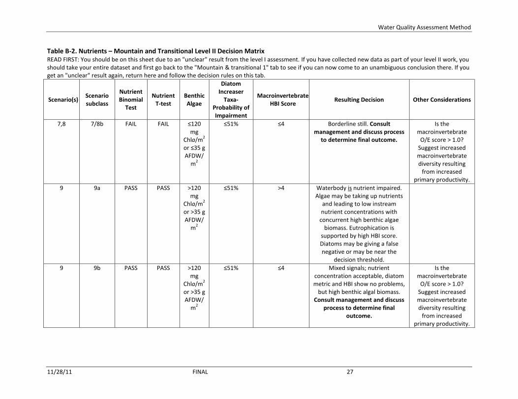
Water Quality Assessment Method
11/28/11 FINAL 27
Table B-2. Nutrients – Mountain and Transitional Level II Decision Matrix READ FIRST: You should be on this sheet due to an "unclear" result from the level I assessment. If you have collected new data as part of your level II work, you should take your entire dataset and first go back to the "Mountain & transitional 1" tab to see if you can now come to an unambiguous conclusion there. If you get an "unclear" result again, return here and follow the decision rules on this tab.
Scenario(s) Scenario subclass
Nutrient Binomial
Test
Nutrient T-test
Benthic Algae
Diatom Increaser
Taxa-Probability of Impairment
Macroinvertebrate HBI Score
Resulting Decision Other Considerations
7,8 7/8b FAIL FAIL ≤120 mg
Chla/m2
or ≤35 g AFDW/
m2
≤51% ≤4 Borderline still. Consult management and discuss process
to determine final outcome.
Is the macroinvertebrate
O/E score > 1.0? Suggest increased macroinvertebrate diversity resulting
from increased primary productivity.
9 9a PASS PASS >120 mg
Chla/m2
or >35 g AFDW/
m2
≤51% >4 Waterbody is nutrient impaired. Algae may be taking up nutrients
and leading to low instream nutrient concentrations with
concurrent high benthic algae biomass. Eutrophication is
supported by high HBI score. Diatoms may be giving a false negative or may be near the
decision threshold.
9 9b PASS PASS >120 mg
Chla/m2
or >35 g AFDW/
m2
≤51% ≤4 Mixed signals; nutrient concentration acceptable, diatom metric and HBI show no problems,
but high benthic algal biomass. Consult management and discuss
process to determine final outcome.
Is the macroinvertebrate
O/E score > 1.0? Suggest increased macroinvertebrate diversity resulting
from increased primary productivity.

Water Quality Assessment Method
11/28/11 FINAL 28
Table B-2. Nutrients – Mountain and Transitional Level II Decision Matrix READ FIRST: You should be on this sheet due to an "unclear" result from the level I assessment. If you have collected new data as part of your level II work, you should take your entire dataset and first go back to the "Mountain & transitional 1" tab to see if you can now come to an unambiguous conclusion there. If you get an "unclear" result again, return here and follow the decision rules on this tab.
Scenario(s) Scenario subclass
Nutrient Binomial
Test
Nutrient T-test
Benthic Algae
Diatom Increaser
Taxa-Probability of Impairment
Macroinvertebrate HBI Score
Resulting Decision Other Considerations
10 10a PASS PASS >120 mg
Chla/m2
or >35 g AFDW/
m2
>51% >4 Waterbody is nutrient impaired. Algae may be taking up nutrients
and leading to low instream nutrient concentrations with
concurrent high benthic algae biomass. Diatoms and HBI score suggests nutrients are the cause.
10 10b PASS PASS >120 mg
Chla/m2
or >35 g AFDW/
m2
>51% ≤4 Mixed signals; nutrient concentration acceptable, diatom metric and HBI show contradictory
results, and there is elevated benthic algal biomass. Consult
management and discuss process to determine final outcome.
Is the macroinvertebrate
O/E score > 1.0? Suggest increased macroinvertebrate diversity resulting
from increased primary productivity.

Water Quality Assessment Method
11/28/11 FINAL 29
Table B-3. Nutrients – Plains Level I Decision Matrix
Scenario
Nutrient Binomial
Test
Nutrient T-test
DO delta
Plains Region Diatom
Increaser Taxa-
Probability of Impairment
Resulting Decision Further
Sampling?
If you have collected the data for, or
have the data for, a
level II assessment:
Notes
1 PASS PASS ≤ 5.3 mg/L
≤51% Waterbody is not nutrient impaired. All indications show that the stream is in compliance.
No
2 PASS PASS ≤ 5.3 mg/L
>51% Unclear — Algae & plants might be taking up nutrients and leading to lower instream nutrient concentrations concurrent with high algae and plant biomass; however, diatom metric contradicts DO delta results. Normally in this scenario TP and/or TN would be expected to exceed criteria. Do a level II assessment to complete decision.
Yes. Do level II assessment. For this scenario this means a required
2nd
summer of data collection.
Collect BOD data.
3 PASS FAIL ≤ 5.3 mg/L
≤51% Waterbody is not nutrient impaired. Suggests pulsed nutrient loads occur but magnitude and durations is not sufficient to manifest problems instream, as shown by compliance with DO delta and diatom metric.
No
4 PASS FAIL ≤ 5.3 mg/L
>51% Waterbody is nutrient impaired. Suggests pulsed nutrient loads occur but DO delta may have given false negative; diatoms however indicate there is a nutrient problem.
No

Water Quality Assessment Method
11/28/11 FINAL 30
Table B-3. Nutrients – Plains Level I Decision Matrix
Scenario
Nutrient Binomial
Test
Nutrient T-test
DO delta
Plains Region Diatom
Increaser Taxa-
Probability of Impairment
Resulting Decision Further
Sampling?
If you have collected the data for, or
have the data for, a
level II assessment:
Notes
5 FAIL PASS ≤ 5.3 mg/L
≤51% Unclear—Nutrient concentrations are in excess of the allowable exceedance rate, but there is no indication of concentrations greatly elevated above the criteria (i.e., passed t-test). No exceedance of DO delta, and diatom increaser taxa in compliance. Inherently high false-negative rates of the response variables could be leading to their outcomes. Do a level II assessment to complete decision.
Yes. Do level II assessment. For this scenario this means a required
2nd
summer of data collection. SEE NOTES TO
RIGHT.
If you suspect problem may be manifested via very high
phytoplankton concentrations,
collect phytoplankton
Chla as well.
6 FAIL PASS ≤ 5.3 mg/L
>51% Waterbody is nutrient impaired. Diatom metric confirms results of the nutrient concentration data (failed binomial, thus elevated nutrients). False negative likely for the DO delta result.
No
7 FAIL FAIL ≤ 5.3 mg/L
≤51% Unclear — Nutrient concentrations are in excess of the exceedance rate and there is indication of concentrations much in excess of the criteria (failed t-test). Inherent high false negative rates of both the diatom metric and DO delta may be why they do not indicate a problem. Do a level II assessment to complete decision. Further nutrient, DO delta, and diatom data sampling is justified.
Yes. Do level II assessment. For this scenario this means a required
2nd
summer of data collection. SEE NOTES TO
RIGHT.
Go to "Plains 2" tab
If you suspect problem may be manifested via very high
phytoplankton concentrations,
collect phytoplankton
Chla as well.

Water Quality Assessment Method
11/28/11 FINAL 31
Table B-3. Nutrients – Plains Level I Decision Matrix
Scenario
Nutrient Binomial
Test
Nutrient T-test
DO delta
Plains Region Diatom
Increaser Taxa-
Probability of Impairment
Resulting Decision Further
Sampling?
If you have collected the data for, or
have the data for, a
level II assessment:
Notes
8 FAIL FAIL ≤ 5.3 mg/L
>51% Waterbody is nutrient impaired. Both assessments of nutrient concentrations indicate elevated concentrations, and the diatom increaser taxa metric shows a nutrient impact. DO delta measurements may have missed high values (i.e., false negative).
No
9 PASS PASS > 5.3 mg/L
≤51% Unclear — Algae & plants might be taking up nutrients and leading to lower instream nutrient concentrations concurrent with high algae and plant biomass; however, diatom metric contradicts DO delta results. Normally in this scenario TP and/or TN would be expected to exceed criteria. Do a level II assessment to complete decision.
Yes. Do level II assessment. For this scenario this means a required
2nd
summer of data collection.
Collect BOD data. SEE NOTES TO
RIGHT.
Go to "Plains 2" tab
If you suspect problem may be manifested via very high
phytoplankton concentrations,
collect phytoplankton
Chla as well.
10 PASS PASS > 5.3 mg/L
>51% Unclear — Algae may be taking up nutrients and leading to low instream nutrient concentrations with concurrent high algae and plant biomass; diatom metric supports this idea as do the DO delta results. Normally in this scenario TP and/or TN would be expected to exceed their criteria. Do a level II assessment to complete decision.
Yes. Do level II assessment. For this scenario this means a required
2nd
summer of data collection.
Collect BOD data. SEE NOTES TO
RIGHT.
Go to "Plains 2" tab
If you suspect problem may be manifested via very high
phytoplankton concentrations,
collect phytoplankton
Chla as well.

Water Quality Assessment Method
11/28/11 FINAL 32
Table B-3. Nutrients – Plains Level I Decision Matrix
Scenario
Nutrient Binomial
Test
Nutrient T-test
DO delta
Plains Region Diatom
Increaser Taxa-
Probability of Impairment
Resulting Decision Further
Sampling?
If you have collected the data for, or
have the data for, a
level II assessment:
Notes
11 PASS FAIL > 5.3 mg/L
≤51% Waterbody is nutrient impaired. Non-compliance with the T-test suggests that pulsed nutrient loads are allowing high algae and plant biomass to be maintained, Diatoms may be giving a false negative.
No
12 PASS FAIL > 5.3 mg/L
>51% Waterbody is nutrient impaired. Non-compliance with the T-test suggests that pulsed nutrient loads are allowing high algae and plant biomass to be maintained, Diatoms confirm enrichment finding.
No
13 FAIL PASS > 5.3 mg/L
≤51% Waterbody is nutrient impaired. Suggests sustained nutrient values above the standard but not necessarily pulsed nutrient loading. Diatom metrics may be giving a false negative.
No
14 FAIL PASS > 5.3 mg/L
>51% Waterbody is nutrient impaired. Suggests sustained nutrient values above the standard but not necessarily pulsed nutrient loading.
No
15 FAIL FAIL > 5.3 mg/L
≤51% Waterbody is nutrient impaired. Most indicators show that the stream is not in compliance. Diatoms probably giving a false negative.
No
16 FAIL FAIL > 5.3 mg/L
>51% Waterbody is nutrient impaired. All indicators show that the stream is not in compliance.
No

Water Quality Assessment Method
11/28/11 FINAL 33
Table B-4. Nutrients – Plains Level II Decision Matrix READ FIRST: You should be on this sheet due to an "unclear" result from the level I assessment. If you have collected new data as part of your level II work, you should take your entire dataset and first go back to the "Plains 1" tab to see if you can now come to an unambiguous conclusion there. If you get an "unclear" result again, return here and follow the decision rules on this tab.
Sce
nar
io
Sce
nar
io S
ub
clas
s
Nu
trie
nt
Bin
om
ial
Test
Nu
trie
nt
T-t
est
DO
delta
Plains Region Diatom
Increaser Taxa-
Probability of
Impairment
BOD Resulting Decision Notes
2 2a PASS PASS ≤ 5.3 mg/L
>51% > 8.0 mg/L Waterbody may be nutrient impaired, BUT SEE NOTE TO RIGHT TO MAKE FINAL CALL. Possible BOD problem; if DEQ-7 DO standards (1-Day Minimum; use your dawn DO measurements) have not been exceeded, do not list for BOD. If they have, do list for BOD. Consult with your manager on BOD listing details.
Consider diatom samples for which impairment probability
is >51%. If magnitudes are >>> 51% and a high
proportion (50%+) of the diatom sampling event are > 51%, nutrient listing is likely
justified; consult management and discuss
final outcome.
2 2b PASS PASS ≤ 5.3 mg/L
>51% ≤ 8.0 mg/L Waterbody may be nutrient impaired. (1) If the assessment reach meets the conditions in the Notes box to right, waterbody is nutrient impaired. (2) If waterbody does not meet the conditions in the Notes box to right, waterbody is not nutrient impaired.
Consider diatom samples for which impairment probability
is >51%. If magnitudes are >>> 51% and a high
proportion (50%+) of the diatom sampling event are > 51%, nutrient listing is likely
justified; consult management and discuss
final outcome.

Water Quality Assessment Method
11/28/11 FINAL 34
Table B-4. Nutrients – Plains Level II Decision Matrix READ FIRST: You should be on this sheet due to an "unclear" result from the level I assessment. If you have collected new data as part of your level II work, you should take your entire dataset and first go back to the "Plains 1" tab to see if you can now come to an unambiguous conclusion there. If you get an "unclear" result again, return here and follow the decision rules on this tab.
Sce
nar
io
Sce
nar
io S
ub
clas
s
Nu
trie
nt
Bin
om
ial
Test
Nu
trie
nt
T-t
est
DO
delta
Plains Region Diatom
Increaser Taxa-
Probability of
Impairment
BOD Resulting Decision Notes
5 n/a FAIL PASS ≤ 5.3 mg/L
≤51% n/a (1) If visual assessment methods (Fish Cover/Other form) indicate very high levels of algae and/or macrophytes, or phytoplankton density is very high, waterbody is nutrient impaired. Consistent failure of the binomial indicates elevated nutrients. The inherently high false-negative rates of the diatom metrics and DO delta may have prevented those parameters from indicating a problem. (2) If visual assessment does not show very high levels of algae and/or macrophytes, nor are phytoplankton densities high, borderline still. For (2), consult management and discuss process to determine final outcome.
7 n/a FAIL FAIL ≤ 5.3 mg/L
≤51% n/a (1) If visual assessment methods (Fish Cover/Other form) indicate very high levels of algae and/or macrophytes, or very high phytoplankton density, waterbody is nutrient impaired. The inherently high false-negative rates of the diatom metrics and DO delta have likely prevented those parameters from indicating a problem. (2) If visual assessment does not show high levels of algae and/or plants, and phytoplankton densities are not high, borderline still. For (2), consult management and discuss process to determine final outcome.
9 9a PASS PASS > 5.3 mg/L
≤51% > 8.0 mg/L Waterbody is not nutrient impaired. Problem is likely related to BOD, which is an organic enrichment problem. Waterbody should be listed for BOD; consult with your manager on BOD listing details.

Water Quality Assessment Method
11/28/11 FINAL 35
Table B-4. Nutrients – Plains Level II Decision Matrix READ FIRST: You should be on this sheet due to an "unclear" result from the level I assessment. If you have collected new data as part of your level II work, you should take your entire dataset and first go back to the "Plains 1" tab to see if you can now come to an unambiguous conclusion there. If you get an "unclear" result again, return here and follow the decision rules on this tab.
Sce
nar
io
Sce
nar
io S
ub
clas
s
Nu
trie
nt
Bin
om
ial
Test
Nu
trie
nt
T-t
est
DO
delta
Plains Region Diatom
Increaser Taxa-
Probability of
Impairment
BOD Resulting Decision Notes
9 9b PASS PASS > 5.3 mg/L
≤51% ≤ 8.0 mg/L (1) If visual assessment methods (Fish Cover/Other form) indicate very high levels of algae and/or macrophytes, especially if Coontail (Ceratophyllum spp.) dominates, or alternatively, waterbody has very high phytoplankton density, waterbody is nutrient impaired. Algae and/or macrophytes are probably taking up the nutrients. (2) If visual assessment does not show excessive high levels of algae and/or plants, and phytoplankton density is not high, waterbody is probably not nutrient impaired. SEE NOTE AT RIGHT TO MAKE FINAL CALL.
Consider in this scenario how close DO deltas are to the threshold, and how many. If >> 5.3 mg/L and many deltas exceed, nutrient listing is likely justified. If not, site is not nutrient impaired. Consult management and discuss final outcome.
10 10a PASS PASS > 5.3 mg/L
>51% > 8.0 mg/L (1) If visual assessment methods (Fish Cover/Other form) indicate high levels of algae and/or macrophytes, or alternatively, waterbody has very high phytoplankton density, waterbody is nutrient impaired. Algae and/or macrophytes are probably taking up the nutrients. Problem is also related to BOD, and should be listed for BOD as well. (2) If visual assessment methods (Fish Cover/Other form) does not indicate high levels of algae and/or macrophytes, nor is there high phytoplankton density, waterbody should be listed for BOD. For (2), consult with your manager on final nutrient listing decision.
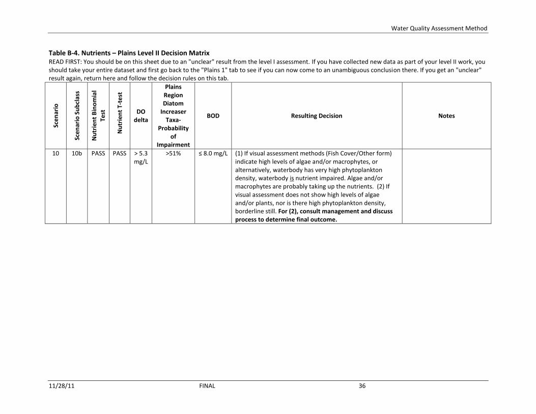
Water Quality Assessment Method
11/28/11 FINAL 36
Table B-4. Nutrients – Plains Level II Decision Matrix READ FIRST: You should be on this sheet due to an "unclear" result from the level I assessment. If you have collected new data as part of your level II work, you should take your entire dataset and first go back to the "Plains 1" tab to see if you can now come to an unambiguous conclusion there. If you get an "unclear" result again, return here and follow the decision rules on this tab.
Sce
nar
io
Sce
nar
io S
ub
clas
s
Nu
trie
nt
Bin
om
ial
Test
Nu
trie
nt
T-t
est
DO
delta
Plains Region Diatom
Increaser Taxa-
Probability of
Impairment
BOD Resulting Decision Notes
10 10b PASS PASS > 5.3 mg/L
>51% ≤ 8.0 mg/L (1) If visual assessment methods (Fish Cover/Other form) indicate high levels of algae and/or macrophytes, or alternatively, waterbody has very high phytoplankton density, waterbody is nutrient impaired. Algae and/or macrophytes are probably taking up the nutrients. (2) If visual assessment does not show high levels of algae and/or plants, nor is there high phytoplankton density, borderline still. For (2), consult management and discuss process to determine final outcome.