water quality degradation in jordan -...
TRANSCRIPT

Country Study Jordan Final Version
Prospects of Efficient Wastewater Management and Water Reuse in Jordan
Country Study
Prepared within the Framework of the EMWATER-Project
“Efficient Management of Wastewater, its Treatment and Reuse in the
Mediterranean Countries”
February 2005
Al al-Bayt University, Mafraq, Jordan
InWEnt, Amman office, Jordan
1

Country Study Jordan Final Version
Table of Content Topic
Page No.
I. The Country
5
1. Introduction
5
2. Country Profile
5
3. Topography
6
4. Climate
7
5. Precipitation
8
6. Evaporation
9
II. Water Resources
10
A. Surface Water Resources
10
1. The Jordan River Area
10
1•1• The Jordan River
10
1•2• Yarmouk River
11
1•3• Zerka River
12
1•4• Wadi El-Arab
14
1•5• Wadi Ziqlab
15
1•6• Wadi Shueib
15
1•7• Wadi Kafrain
16
1•8• Other wadis discharging into the Jordan Valley
17
2. Dead Sea Wadis
17
2.1 Wadi Zerka Ma'in
17
2.2 Wadi Mujib
17
2

Country Study Jordan Final Version
2.3 Wadi El-Karak
18
2.4 Wadi Hasa
18
2.5 Wadis between the major Dead Sea catchment
19
3. Wadi Araba Catchments
19
3.1 The Northern Wadi Araba Catchment
19
3.2 The Southern Wadi Araba Catchment
20
4. Wadi Yutum Catchment
21
5. Jafr Basin Catchment
21
6. Azraq Basin Catchment
22
7. Hammad Basin Catchment
22
B. Groundwater
23
1. Groundwater Aquifers
23
1.1 Deep Sandstone Aquifer Complex
23
1.2 Upper Cretaceous Hydraulic Complex
24
1.3 Shallow Aquifers Hydraulic Complex
25
2. Groundwater Basins in Jordan
25
2.1 Groundwater in the Yarmouk basin and the northern part of the Jordan Valley escarpment
26
2.2 Southern Part of the Jordan Valley Escarpment
28
2.3 Jordan Valley Floor Area
29
2.4 Amman Zerka Area
30
2.5 Dead Sea Area
32
2.6 Northern Wadi Araba
33
2.7 Southern Wadi Araba
34
2.8 Disi-Mudawwara 34
3

Country Study Jordan Final Version
2.9 The Azraq Area
36
2.10 Jafr Area
38
2.11 Sirhan and Hamad Area
39
C. Patterns of Water Use
41
1. Water use
41
1.1 Domestic Uses
41
1.2 Industrial Uses
41
1.3 Agricultural Uses
41
1.4 Total Uses
42
2. Water Balance: Resources versus Consumption
42
III. Waste Water Treatment in Jordan
44
1. Introduction to Waste Water Treatment (WWT)
44
2. Methods of waste water treatment
45
2.1 Conventional waste water treatment
45
2.2 Less conventional methods of waste water treatment
46
IV. Institutional and Legal Frame Work
52
V. Reuse Standards in Jordan
56
VI. Public Awareness
75
VI. References list
77
VII. Annexes
79
4

Country Study Jordan Final Version
I. The Country
1. Introduction: Most of the Middle East region is considered as arid or semi-arid due to the scarcity
of rainfall. This hard nature forced the inhabitants of these areas to move during the year
looking for water and grass to maintain the life of their animals. In consequence, the
movement of the inhabitants through the desert and their instability had negative effect on
their socio-economic and cultural standards of living. To overcome this situation it is of
prime importance to develop the water resources in such areas where it forms the backbone
for any development in the region.
Despite the harsh climatic conditions we believe that water resources can be
developed in the area using old and new techniques. This will inevitably form a solid base to
develop the Wastewater treatment technologies to provide extra water recourses.
2. Country Profile The following represent a brief description of the Hashemite Kingdom of Jordan:
Area: 89.900 km2, (Fig. 1).
Population (1994 statistics) = 5.5 million
Rate of growth: 3.2% per year.
Population projection: 6.8 million by 2010 and 9 million by 2020.
Economic sectors: Agriculture ≈ 10%, industry 22%, services 68%.
Labor force: Agriculture ≈ 11%, industry 27%, services 62%.
Literacy rate: ≈ 80%.
Export: Potash, phosphate, fertilizers, small industrial products, manpower,
vegetables and fruits.
Imports: Fuel, food (grain, meat, etc...), vehicles, heavy machinery, industrial plants,
wood, iron, paper ... etc.
Energy: Only very limited gas fields, large oil shale deposits that are not yet mined.
Finally it shall be mentioned here that the food production in Jordan covers around 50% of
the country's needs.
3. Topography
5

Country Study Jordan Final Version
The country consists of different distinctive topographic units trending in a general
north-south direction. These units seem to be dictated by a major geologic event which
incorporates rifting along the Jordan Valley, Dead Sea, Wadi Araba, Red Sea line, which,
during the last few tens of millions of years led to the formation of the rift valley along the
same line with the corresponding highlands on both sides sloping in Jordan to the steppe in
the east.
The rift valley forms the western part of the country. It trends in a general south-
north direction from the Gulf of Aqaba through the Dead Sea to Lake Tiberias. The
elevation of the bottom of the valley ranges from sea level in Aqaba at the shores of the Red
Sea to around 240m ASL at a distance of 80km to the north, and from there it drops
gradually to about 400km BSL at the present shores of the Dead Sea and further to around
750m BSL at the bottom of the Dead Sea, (Emery and Neev 1967). To the north of the Dead
Sea the floor elevation rises gradually to around 210m BSL at the shores of Lake Tiberias.
This rift valley, with a length of 375km, is about 30km wide in the area of Wadi Araba and
narrows to around 4km in the Lake Tiberias area.
The highlands east of the Jordan rift valley rise to elevations of more than 1000m
ASL in the north at Ajlun and Balqa and to more than 1200m ASL in Shoubak and Ras El
Naqab areas. The width of this zone ranges from 30 to 50kms and extends from the
Yarmouk River in the north to Aqaba in the south. These elevations drop gradually to the
plateau in the east, but more sharply to the rift valley in the west. The mountains forming
the highlands consist mainly of sedimentary rocks with deeply incised wadies draining in a
westerly direction.
The steppe or plateau of Jordan developed at the eastern toes of the highlands with
elevations of drainage areas ranging from 1000m ASL in the south to 700m in the northeast.
The deepest part of this plateau lies at an elevation of 500m ASL; Azraq Oasis. The plateau
is a peneplain with hills and weakly incised wadis, but generally a smooth topography.
Surface water, if not captured by westerly draining wadies, discharges into desert playas or
qaas forming extended shallow lakes in winter and dry mud flats in summer.
6
Country Study Jordan Final Version
The northeastern part of the country "the pan handle" is a flat plateau with a very
smooth topography, which rises from 500m in Azraq area to about 900m at the Jordan-
Iraq borders. It is interrupted by volcanic mountains, which rise to about 150m above
the plateau level. The southern desert forms also a flat area intersected by partly deep
incised wadis. The topography rises in its southwestern parts to more than 1500m ASL
(Aqaba Mountains).
The most southern part of the plateau, which lies to the south of the Ras El Naqab
escarpment, is considered a different topographic unit, although it belongs to the same
plateau. This is because it is separated from the plateau by the prominent topographic
feature; the escarpment, because it drains to the Dead Sea and because of its steep
topography dictated by a different geology consisting of sandstones and a granitic
basement complex. The elevation of the area is around 900m ASL, with a north-south
width of around 100kms. This part of the country is sometimes referred to as the
southern desert. It is strongly dissected by wadis with very rough topography in the
western part and smooth topography in the eastern part.
4. Climate Jordan can be classified as a semi-desert area. Only the highlands, with a width
of around 30 km and a length of some 300 km, enjoy a Mediterranean type climate.
Temperatures in the Jordan Valley, Wadi Araba and Aqaba can rise in summer to 45°C
with an annual average of 24°C. In winter the temperature in this area reaches a few
degrees above zero. Frost is a seldom event.
Along the highlands the climate is relatively temperate; cold and wet in winter
with temperatures reaching a few degrees below zero during the night, to hot and dry in
summer with temperatures reaching 35°C at noon, but with a relative humidity of 15-
30%, which makes the heat more acceptable. During the hot summer, temperatures at
night drop to less than 20°C and cause dew to form.
The plateau; the eastern and southern deserts are hot in summer and cold in
winter. The temperature may reach more than 40°C during summer days and drop in
7
Country Study Jordan Final Version
winter to a few degrees below zero, especially during the night. Also here, the relative
humidity is low. In winter it is generally around 50-60%, and in summer it sometimes
drops to 15%. The low relative humidity throughout most of the year makes the hot
summer days more tolerable and the cold winter days more severe.
5. Precipitation Precipitation (ppt) in Jordan falls normally in the form of rainfall. Snowfall
occurs generally once or twice a year over the highlands. The rainy season extends from
October to April, with the peak of precipitation taking place during January and
February. These peaks become less pronounced the scarcer the rainfall an area receives
(Fig. 2).
The highest rates of ppt fall over the highlands of Ajlun, Balqa, Karak and
Shoubak which receive long-term annual averages of 600, 550, 350 and 300mm
respectively. To the east of these highlands, and more strongly to the west, ppt
decreases drastically (Fig. 3), e.g., (it decreases from an average of 600mm/year in Ajlun
to 250mm/year in the Jordan Valley) within a distance of 10kms and a difference in
altitude of 1200m. The decrease in easterly direction is twice to three times slower than
due west; e.g. (from 300mm/year in Shoubak to 50mm/year some 30kms east of the
town).
Generally, the following facts can be stated about precipitation in Jordan:
• The average annual amount of water falling over Jordan's territories is 7200 MCM
increasing to 12000 MCM in a wet year and decreasing to 6000 MCM in a dry year.
• Only around 1.3% of Jordan's area receives an average annual ppt of more than 500
mm, only 1.8% between 300 and 500 mm, 3.8% between 200 and 300 mm, 12.5%
between 100 and 200 mm and the rest, 80.6%, receive less than 100mm/year.
The above is still an inadequate picture of Jordan's water situation. But knowing that
only about 3% of the total area of the country receives an average annual amount of ppt
exceeding 300mm may illustrate the situation better. Worth mentioning is that 300 mm/year
of ppt is the least amount needed to grow wheat in dry farming areas under the prevailing
8

Country Study Jordan Final Version
climatic conditions. In addition, 83% of the total amount of ppt occurs in areas receiving less
than 300mm/year, which means that only 17% of ppt can be used in dry farming. The rest of
83% requires certain technologies to be made available for the different uses. An exception,
is range land, where 300 - 150mm/year of ppt may be adequate. A part of ppt water flows in
wadis, and it either collects in dams or in desert playas. Another part infiltrates and joins the
groundwater resources of the country. The dry climate, the atmospheric dust and the low
intensity of precipitation affects also the quality of precipitation water, generally reflected in
increasing salt contents.
6. Evaporation: The climatic conditions in Jordan do not only affect the amount and distribution of
precipitation, but they also impact strongly the potentials of evaporation which range from
about 1600mm/year in the extreme northwestern edge of the country to more than
4000mm/year in the Aqaba and Azraq areas. Along the rift valley the potential evaporation
increases from a minimum of 2000mm/year in the north, to some 2500mm/year in the Dead
Sea and to more than 4000mm/year in Aqaba. These rates are 5 to 80 times the average
amounts of ppt these areas receive.
Potential evaporation rates of the plateau areas increase in easterly and southerly
directions from an average of 3000mm/year at the eastern toes of the highlands to around
4000 in the center of the plateau. The southern rates are 3500 to 4400 mm/year. Potential
evaporation rates of the plateau and southern desert are 12 to 100 times the amount of ppt
falling over these areas. The high evaporation potential all over the country makes
precipitation, especially in the eastern and southern parts of the country, ineffective because
ppt-water readily evaporates, leaving soils deprived of their moisture content and hence, not
allowing for the development of plants. The high evaporation rates and the low precipitation
amounts lead generally to salt concentrations of the water which increases the salinity of
infiltrating, and in dam-stored water.
II. Water Resources
A. Surface Water Resources
9

Country Study Jordan Final Version
Jordan does not possess rivers in the world-wide known scale, except the Jordan
River which used to discharge around 1400 MCM/year into the Dead Sea before the
development of the water resources in its catchment. Even this river is a very small source
compared with international rivers like the Nile or Euphrates, because its total annual
discharge amounts to only 1.5% of the former and 4.3% of the latter. Other surface water
resources in Jordan are found in the Yarmouk and Zerka rivers and in wadis like Karak,
Mujib, Hasa, Yabis and El-Arab, in addition to flood flow wadis in the different parts of the
country.
1. The Jordan River Area: 1·1· Jordan River
The surface catchment area of the Jordan River measures 18.194 Km², of which 2833
Km² lie upstream of the Lake Tiberias outlet. The eastern catchment area, downstream of
Tiberias, measures 13.027 Km², and the western, 2344 Km². The headwaters of the Jordan
River originate from three main springs: Hasbani in Lebanon; Dan in Israel; and Banias in
Syrian territory occupied by Israel. The three streams join in Israel to form the Upper Jordan
River. The surface catchments of the springs do not alone account for the large quantities of
water discharged from them; therefore, their underground watershed must extend further to
the north, northeast and eventually north-west, beyond the surface catchments and into Syria
and Lebanon.
The total discharge of the Jordan into the Dead Sea -- prior to the implementation of
the different water projects in Jordan, Syria and Israel -- was 1370 MCM/year. This amount
has now declined to a mere 250-300 MCM/year -- mostly as irrigation return flow, inter-
catchment runoffs or saline spring discharges. Saline springs in the immediate surroundings
of Lake Tiberias and at its bottom are channeled downstream of Tiberias into the headwaters
of the Lower Jordan River.
The discharge of the Yarmouk River into the Jordan River was around 400
MCM/year prior to the use of the water by the different riparian. In the last few years, this
amount has gradually declined to small discharges, only as a result of large floods, which
cannot be accommodated by the existing extraction facilities.
10

Country Study Jordan Final Version
The other wadies and springs on both sides of the Jordan Valley are dammed or
captured by other constructions. Water remains runoffs due to rains over areas downstream
of water collection constructions, return flows or saltwater discharges which then joins the
river.
1·2· Yarmouk River
The Yarmouk flows at the borders of Syria and Jordan and joins the Jordan River in
an area partly occupied by Israel. The river drains both flood and base flows of Jordanian
and Syrian territories. The total catchment area of the river measures 6790 Km², of which
1160 Km² lie within Jordan upstream of Adasiya and the rest within Syria and in the Jordan
River area downstream of Adasiya.
Along its course from the foothills of Jabel Druz to its confluence with the Jordan
River, many important wadies and creaks in terms of water quantities join the Yarmouk like
Harir, Allan and Raqqad in Syria and Shallala and El Humra in Jordan.
The catchment area of the Yarmouk River is agrarian, with small types of industries
located in the main towns in Jordan and Syria. The small effluents of two waste water
treatment plants (stabilization ponds) reach the river during floods. Also, the leachates of El-
Ukheider solid waste disposal sites directly reach the river course on days when their liquid
loads exceed evaporation and infiltration potentials.
The average annual rainfall over the catchment area is 372 mm/yr. In the
northwestern parts of the catchment, which border on the Hermon Mountains, precipitation
increases to an average of more than 1000 mm/yr. It decreases to 250 mm in the
southeastern corner of the catchment. The discharge of the Yarmouk River in Adasiya during
the forties, fifties and beginning of the sixties of this century is given in the literature to equal
467 MCM/yr. (1927-1964). More recent measurements, although masked by unknown
usage of the riparians, indicate a decline in the river discharge, conditioned by: increasing
extractions from the groundwater in the catchment area, which leads to declining base flow;
and decreasing precipitation in the last five decades (Salameh 1993).
11

Country Study Jordan Final Version
The river flow during the period 1950 to 1976 averaged 400 MCM/year. Recent
measurements of flows and estimates of riparian extractions indicate an average total
discharge of around 360 MCM/year.
The water quality of the Yarmouk River reflects the land uses within the catchment
area, which are still restricted to rainfed and some irrigated agriculture. Pollution parameters
can be measured in the discharged water especially during low flows.
1·3· Zerka River
This Zerka River is the second largest in Jordan in the area of its drainage basin and its
mean annual discharge. The catchment area measures 4025 Km² and extends from the
foothills of Jabel Druz to the Jordan Riveer
The river consists of two main branches; Wadi Dhuleil, which drains the eastern part
of the catchment area, and Seel-Zerka, which drains the western part. Both meet at Sukhna to
form the Zerka River. Naturally, the eastern branch drains only flood flows as a result of
precipitation, whereas the western branch drains flood and base flows. The most densely
populated area in Jordan which is the catchment area of Zerka River comprises around 65% of
the country's population and more than 80% of its industries.
The urban waste waters are generally sewage and treated in different waste water
treatment plants to varying degrees. Also, most industries located in the catchment area treat
their waste waters before discharge into the surface water system. In addition, solid waste
disposal sites are located within the catchment area. Their leachates reach surface and
groundwater resources causing local pollution and threatening to contaminate the aquifers.
The catchment area of Zerka River receives an average annual precipitation of
237mm. The eastern catchment, which comprises around half of the total catchment area,
receives an average amount of precipitation of 182 mm/year. The middle part between the
12

Country Study Jordan Final Version
eastern catchment and the western highlands receives an average of 243 mm/year. The
western catchment, comprising the highlands and the Jordan Valley area, receives an average
of 397 mm/year.
Precipitation over the highlands may be in the form of snow; in the eastern part of the
catchment it is generally rainfall. The highest amount of precipitation falls over the highlands
of Salt and Amman. In an average year it reaches 550mm; it increases in a wet year to
750mm and decreases in a dry year to 350mm. In the most eastern part of the catchment the
average precipitation in a normal year is 80mm, increasing to 150mm in a wet year and
decreasing to 50mm in a dry year.
The potential evaporation ranges from 1600mm/year along the western highlands, to
2000mm/year in the eastern part of the catchment. Meanwhile, there is not enough water to
satisfy the needs of the evaporation force of the climate, which is far less during the winter
months than during the summer months -- a fact which allows precipitation water to infiltrate
and recharge the ground water during the rainy season.
The average annual discharge of Zerka River at Deir Alla for the years 1950 to 1976
was 64.88 MCM/year. After 1976, the natural system of the river was changed by different
factors such as construction of the King Talal Dam on the Zerka River (1977), importing
water into the catchment area for domestic and industrial uses and discharging their effluents
to the Zerka River system.Such activities controlled the river flow and increased its discharge
on the one hand, and negatively affected its water quality on the other.
The King Talal Dam on the Zerka River was commissioned in 1977 with a total
capacity of 56 MCM, which was raised in 1988 to 89 MCM. The natural flow of the Zerka
River can not fill the dam in an average year. But since increasing amounts of water were
imported into the catchment area from other areas to satisfy the increasing demand, effluents
reaching the dam are expected to fill it almost yearly.
At present, the domestic and industrial waste water contributions to the inflows of the
river are estimated at 50% of its discharge. The water quality of the river changes dramatically
between summer and winter. In winter, flood water constitutes most of the river discharge,
13

Country Study Jordan Final Version
and although it contains domestic refuse and waste water, the quality during floods remains
acceptable for most uses.
1·4· Wadi El-Arab
The catchment area of Wadi El-Arab borders the Yarmouk catchment and measures
267km².The average amount of precipitation ranges from 500mm over the highlands west of
Irbid, to 350mm in the Jordan Valley (North Shuna). The potential evaporation ranges from
2000mm/year in the northwest, to 2400mm/year in the southwest of the catchment.The
average discharge of the wadi is around 28 MCM/year equally distributed between flood and
base flows.
A dam was constructed on Wadi El-Arab in 1987, with a total capacity of 20 MCM to
collect flood and base flows for use in irrigation in the Jordan Valley area. Since its
completion the dam was filled by waters originating within its catchment, only in the very wet
year of 1991/92. In the other years, water was pumped from King Abdallah Canal during
floods to increase the stored amount of water in the dam for use during the dry season. The
catchment area is agrarian, but Irbid City is expanding westward into the catchment, which
may put increasing pressure on the quality of the water collected in the dam.
The wastewater treatment plant for Irbid City was constructed in the upper reaches of
Wadi El-Arab. And although the effluent of the treatment plant is piped to bypass the dam,
floodwaters still enter the treatment plant and wash its contents and the wastes along Wadi El-
Arab into the dam reservoir, negatively affecting its water quality. Drilling of wells and
pumping of water upstream of the dam resulted in groundwater level declines and hence the
ceasing of groundwater natural discharges. In the last ten years the drop in the ground water
levels in Wadi El-Arab wells exceeded 25m -- a fact which questions the future reliability and
durability of this drinking water source supplying Irbid governorate.
The water collected in the dam is generally of good quality and can be used for
different purposes. When used for domestic purposes, conventional treatment of filtration and
chlorination is sufficient. Of some concern is the relatively high trihalomethane potential,
especially the formation of bromoform during the dry season upon water chlorination.
14

Country Study Jordan Final Version
1·5· Wadi Ziqlab
The catchment area of Wadi Ziqlab measures 106km² and extends from the Jordan
Valley eastwards into the highlands. Its eastern parts receive an average amount of
precipitation of 500mm/year, whereas its western parts in the Jordan Valley receive only
300mm/year.
The potential evaporation ranges from 2050mm/year in the west to 2200mm/year in
the east. Various springs issue along Wadi Ziqlab with a total discharge of some 5
MCM/year. In addition Wadi Ziqlab drains another 5 MCM/year of floodwater.
A dam was constructed in Wadi Ziqlab with a total capacity of 4.3 MCM in 1966,
and with the aim of using its water for irrigation in the Jordan Valley area. The catchment
area is agrarian with natural forests and very little population.
1·6· Wadi Shueib
Wadi Shueib drains an area of approximately 180km² lying to the west of Suweileh
region at elevations of 1200m down to below sea level. Precipitation over the catchment
area partly falls in the form of snow in its eastern parts and ranges on average from
500mm/year in Suweileh and Salt mountains to 150mm in the Jordan Valley area.
The potential evaporation ranges from 2700mm/year in the eastern parts to 2500
mm/year in the western parts. The average natural flow of the Wadi is 1.8 MCM/year as
flood flow and 3.9 MCM/year as base flow. In addition the effluent of the Salt town
wastewater treatment plant, one of the best functioning in Jordan, is discharged into the wadi.
In the catchment area different towns and villages, like Salt, Fuheis and Mahis,
discharge their treated and untreated wastes along the wadi and its tributaries.A dam was
constructed in Wadi Shueib in 1968 with a capacity of 2.3 MCM and with the aim of using
its water for irrigation in the Jordan Valley. In addition to base and flood flows, this dam
now receives irrigation return flows and the effluent of the well-functioning Salt town waste
water treatment plant.
1·7· Wadi Kafrain
15

Country Study Jordan Final Version
Wadi Kafrain drains an area west of Amman with an extent of 189 km² lying at
elevations ranging from 1200m ASL down to areas lying below sea level in the Jordan
Valley. Precipitation in the eastern parts of the catchment, averaging 550mm/year, may fall
in the form of snow, whereas in the western parts the average reaches only 150mm/year and
falls completely in the form of rain.
The potential evaporation ranges from 2700mm/year in the eastern parts to 2400
mm/year in the western parts. The average discharge of Wadi Kafrain is 6.4 MCM/year,
consisting of 1.6 MCM/year flood flow and 4.8 MCM/year base flow. In addition, Wadi Sir
and Hussein Medical Centre wastewater treatment plants end up in Wadi Kafrain or its
tributary wadies. In the catchment area different towns and villages, like Wadi Sir and Naur,
discharge their wastes along Wadi Kafrain or its tributaries.
In 1968, a dam was constructed at the entrance of Wadi Kafrain into the Jordan
Valley with a capacity of 3.8 MCM. This dam now serves as a storage facility for irrigating
downstream lands and for recharging the underlying aquifer. It is now being raised to a
capacity of 7 MCM.
At present, the dam receives in addition to flood and base flows, irrigation return
flows, treated and untreated waste waters and groundwater discharged from artesian wells
drilled into the lower pressurized aquifer. Hence, it receives good quality water from springs
and artesian wells, medium quality water of floods mixed with treated and untreated waste
waters and bad quality water from irrigation return flows and waste water treatment plants.
1·8· Other Wadies Discharging into the Jordan Valley
These wadies are not dammed and include Yabis, Kufranja, Jurum, Rajib, Hisban and
other small catchments. The rainfall on these areas ranges from 150 mm/year up to 550
mm/year, with potential evaporation rates ranging from 2100 mm/year to 2700 mm/year.
16

Country Study Jordan Final Version
The base flow of these wadis is used in irrigation along their courses and partly at the
foothills on the Jordan Valley. Flood flows still reach the Jordan River lower stem.
2. Dead Sea Wadies 2·1· Wadi Zerka Ma'in
The catchment area of Wadi Zerka Ma'in measures 272 km² and ranges in elevation
from 1000m ASL to 400m BSL. Precipitation over the catchment falls in the form of rain and
ranges from 350 mm/year in the highlands surrounding Madaba city to 100 mm/year at the
shores of the Dead Sea. The potential evaporation rates range from 2900 mm/year in the east
to 2400 mm/year in the west at the shores of the Dead Sea.
Zerka Ma'in discharges directly into the Dead Sea an average amount of 23
MCM/year, of which only around 3 MCM/year as flood flows and 20 MCM/year as base
flow. The base flow consists of thermal water issuing from tens of springs ranging in
discharge from seepage size to 150 l/s.
2·2· Wadi Mujib (including Hidan)
The catchment area of Wadi Mujib measures 6.596 km² and ranges in elevation from
1100m BSL. Precipitation over the catchment area falls in the form of rain and seldom in the
form of snow. It ranges from 350 mm/year along the mountain highlands to 100mm/year at
the shores of the Dead Sea.
The potential evaporation in this catchment ranges from 2450 mm/year at the shores of
the Dead Sea to 3500 mm/year in the eastern part of the catchment. Wadi Mujib downstream
of the confluence of Wadi Hidan discharges an average amount of 83 MCM/year directly into
the Dead Sea. Half of the river flow consists of base flow and the other half of flood flows.
The lower reaches of the wadi system contribute with an average base flow of around
30 MCM/year of mostly lightly mineralized water issuing from the sandstone aquifer
complex. The salinity of some springs resembles those of Zerka Ma'in, containing around
2000 mg/l of dissolved salts.
17

Country Study Jordan Final Version
The catchment area is sparsely inhabited, with moderate agricultural activity and
almost no industry. Therefore, water pollution is not a major issue in Wadi Mujib area.
2·3· Wadi El-Karak
The catchment area of Wadi El-Karak measures 190 km² and lies at elevations ranging
from 1000m ASL to 400m BSL. The average precipitation falling over the catchment area
ranges between 350 mm/year in the high mountains and 100 mm/year along the shores of the
Dead Sea. The potential evaporation ranges from 2600 mm/year at the shores of the Dead Sea
up to 3100 mm/year along the highlands.
The catchment of Wadi El-Karak is a moderately inhabited and agrarian area. It
includes the city of Karak and numerous towns and villages. Karak city possesses a waste
water treatment plant the effluent of which discharges into Wadi Karak. As in the case of
other Dead Sea wadis, the lower reaches of Wadi El-Karak are rich in springs and water
seepage issuing from the sandstone aquifers. The average discharge of Wadi El-Karak is
around 18 MCM/year, of which 15 MCM/year issue as base flow. The base flow is generally
used in irrigation along the intermediate reaches of the wadi.
2·4· Wadi Hasa
The catchment area of Wadi Hasa lies to the southeast of the Dead Sea, but the water
flowing in Wadi Hasa discharges directly into the Dead Sea, hence, it is considered one of the
Dead Sea catchment areas and measures 2520 km² and is the second largest among the Dead
Sea catchments after Mujib.
Precipitation over the area ranges from 300 mm/year along the highlands down to
100mm/year in the Dead Sea area and 50mm/year over the eastern parts of the catchment.
Precipitation over the highlands sometimes falls in the form of snow.The potential
evaporation rates range from 2800 mm/year in the Dead Sea area up to 3900 mm/year in the
eastern parts of the catchment.
The average discharge of Wadi El-Hasa is around 34 MCM/year. Only about 2
MCM/year flow as floods, and the rest consists of groundwater discharges along the lower
reaches of the wadi. Like the other catchments of the Dead Sea, the groundwater discharged
along the lower reaches consists partly of mineralized thermal water.The catchment area is
18

Country Study Jordan Final Version
sparsely populated, with no industries and very low agricultural activities. Therefore, it is not
expected that water pollution has taken place.
2·5· Wadies between the Major Dead Sea Catchments
Different small areas between the major Dead Sea catchments discharge directly into
the Dead Sea. These areas between Wadi Hisban and Zerka Ma'in, Zerka Ma'in and Mujib,
Mujib and Karak and Karak and Hasa measure a total of 972 km², with a total discharge of
around 30 MCM/year. This discharge comes almost completely from groundwater issuing
along the lower reaches of the wadies as thermal water.
3. Wadi Araba Catchments Wadi Araba itself is not a base level for either surface or groundwater. Both
discharge either to the Dead Sea or to the Red Sea. The northern part of Wadi Araba
discharges into the Dead Sea and the southern one into the Red Sea via the Gulf of Aqaba.
3·1· The Northern Wadi Araba Catchment
The northern Wadi Araba catchment extends for about 100 km from the Dead Sea
shore southward, with a width of 25 to 30 km and a total area of 2938 km². Precipitation
falls in the form of rainfall, except on the highlands where it may fall in the form of snow.
The average long term precipitation is 300 mm/year over the mountains and 100 mm/year in
Wadi Araba area. The potential evaporation ranges from 2800 mm/year at the southern
shores of the Dead Sea to 3500 mm/year in the southeastern parts of the catchment.
Different wadies drain the catchment into Wadi Araba. The major ones are Wadi
Khuneizir, Wadi Fidan and Wadi Buweirida, with average discharge of about 11, 4, 5.5 and 3
MCM/year respectively. The major part of discharge comes from the base flow of the wadis.
In addition to the major wadis, numerous small ones drain the area. The overall total
discharge of all the northern wadis into Wadi Araba is 26 MCM/year.The flood flows, which
reach Wadi Araba infiltrate rapidly into the course-grained alluvium deposits building the
bottom of the wadi. They seldom directly reach the Dead Sea. But the infiltrated water
flows in a northerly direction to reach the Dead Sea as seepage or submarine springs.
19

Country Study Jordan Final Version
The catchment area is sparsely populated. The main centers are Tafilah and Shoubak
which are devoid of industries. Agriculture is practiced in the highlands, where rain fed
crops are produced along the wadi courses and in Wadi Araba, where the base flows of wadis
and pumped groundwater are used for irrigation. The area still possesses a certain potential
for developing agriculture and for improving the efficiency of irrigation projects.
The domestic wastewater of Tafilah is treated in a wastewater treatment plant, and the
effluent is discharged along Wadi Fifa. The amount of effluent is very small (a few hundred
cubic meters daily) and it infiltrates along the wadi and discharges with the groundwater
issuing along the lower reaches of Wadi Fifa or it joins the groundwater in Wadi Araba.The
total groundwater throughput of northern Wadi Araba into the Dead Sea is calculated to
average 22 MCM/year (Abu Zirr, 1989).
3·2· The Southern Wadi Araba Catchment
The area extends around 75 km north of the Gulf of Aqaba, with a maximum E-W
width of 30 km. The total catchment area measures 1278 km² with an average precipitation
of 150 mm/year in the northeastern parts and less than 50 mm/year in the southern parts and
Aqaba area. The potential evaporation rates range from 3300 mm/year in the north to 4100
mm/year in the southern part.The area is barren, with very low population density (less than
1 person/km²). Also, the type of climate and aridity do not support life and do not allow
urbanization.
The total water discharge from the eastern wadis into the area is estimated at 1
MCM/year, indicating the very low potentialities of the area. The throughput of southern
Wadi Araba into the Red Sea is around 10 MCM/year. This groundwater originates as an
aquifer to aquifer discharge coming from the eastern highlands. At the southern end of Wadi
Araba, a few kilometers from the Gulf of Aqaba, a flowless water treatment plant was
constructed to serve Aqaba city.
4. Wadi Yutum Catchment
Wadi Yutum catchment drains an extensive area in southwest Jordan, east of Aqaba
into the Red Sea. The extent of the catchment is 4.400 km². Precipitation over the area falls
in the form of rainfall and ranges from 150 mm/year in the highlands to less than 50 mm/year
20

Country Study Jordan Final Version
in the central and eastern parts of the catchment area. The potential evaporation is very high
and ranges from 3400 mm/year in the western parts up to 3800 mm/year in the eastern and
southern parts.
Since the area is flat, precipitation water infiltrates into the barren rocks, mostly
consisting of sandstones and weathered rocks. There are no groundwater discharges in the
area, and the surface water forms as floods resulting from intense precipitation. But even that
is a very small amount of 1.5 MCM/year compared with the extent of the catchment area.
5. Jafr Basin Catchment
Jafr Basin is an exitless depression in southern Jordan, with a catchment area of
12.200 km². It is a flat area bordering the highlands in the west. The average precipitation
ranges from 200 mm/year at the foot of the highlands to 30 mm/year in the middle and eastern
parts of the catchment. The potential evaporation ranges from 3300 mm/year in the western
parts of the catchment to 4000 mm/year in the center of the depression.
The total discharge of the catchment is around 15 MCM/year, of which 10 MCM/year
flow as floods into the Jafr depression, where they either evaporate or infiltrate into the
ground down there. The base flow, in the form of spring discharge, is totally used in
irrigation.
The catchment area is very sparsely populated, with Ma'an and Shoubak as major
urban centers. Agriculture has been developed along the foothills of the mountains in the
west by extracting groundwater. The main industry in the area is a cement factory located in
the northwestern edge of the catchment.
6. Azraq Basin Catchment
21

Country Study Jordan Final Version
The Azraq Basin is an exitless depression in the eastern plateau of Jordan. The bottom
of the basin lies at an altitude of 500m ASL. The drainage basin measures 11.600 km² and
extends in the north beyond the borders of Jordan.
Precipitation falls in the form of rain and ranges from 300 mm/year over the Jabel
Druz southern slopes to less than 50 mm/year in the Azraq depression itself. The average
precipitation over the area is 90 mm/year. The potential evaporation ranges from 3300
mm/year in the northern parts of the catchment to 4000 mm/year in the central and eastern
parts.
The total discharge into the basin is around 27 MCM/year, of which 15 MCM/year
issue as groundwater from different springs in the Azraq Oasis itself. Surface water comes as
floods from wadis pouring into the depression as a result of precipitation events over the
catchment. Few dispersed urban centers and industries are found in the catchment area.
7. Hammad Basin Catchment
Hammad Basin is a very large, flat plateau extending in four countries: Jordan, Syria,
Iraq and Saudi Arabia. In Jordan, the area measures 19.270 km.
Precipitation over the area ranges from 150 mm/year to 50 mm/year, with potential
evaporation rates of 3800 mm/year. Since the area is flat, different surface water collection
sites (playas) developed. As a result of precipitation, during the rainy season hundreds of flat
areas fill with up to two meters of water, which either evaporate or infiltrate to the
underlying aquifers and flow very slowly to ultimate base levels like Sirhan depression, the
Dead Sea or the Euphrates area. What remains in the playas after evaporation are salty silts
waiting for the next flood .The amount of surface runoff is relatively small and averages 5
MCM/year, whereas the groundwater, which forms in the area, averages around 10
MCM/year.
B. Groundwater
22

Country Study Jordan Final Version
1. Groundwater Aquifers
The groundwater aquifers of Jordan are divided into three main complexes, (Fig. ).
Deep Sandstone Aquifer Complex.
Upper Cretaceous Aquifer Complex.
Shallow Aquifer Complex.
1.1. Deep Sandstone Aquifer Complex:
This complex forms one unit in southern Jordan. To the north, gradually thick
limestones and marls separate it into two aquifer systems which, nonetheless, remain
hydraulically interconnected.
A. Disi Group Aquifer (Paleozoic):
This is the oldest, and in the north, the deepest water bearing sediment sequence in
Jordan consisting of sandstones and quartzites. It crops out only in the southern part of
Jordan and along Wadi Araba - Dead Sea Rift Valley. It underlies the entire area of Jordan.
The southern part of the complex forms the fresh water aquifer of the upper Wadi Yutum -
Disi-Mudawwara area.
The main flow of the groundwater in this system is directed towards the northeast.
Only in the southern parts a groundwater divide in the Rum area separates a small southern
region where the groundwater moves towards the west and south.
B. Kurnub and Zerka Group of Jurrassic-Lower Cretaceous Age:
This is also a sandstone aquifer underlying the area of Jordan and overlying the Disi
group aquifer. It crops out along the lower Zerka River basin and along the escarpment of
the Dead Sea, Wadi Araba and Disi region.
Wells drilled in this fine-grained sandstone aquifer have fairly good yields. Direct
recharge, however, is limited to small outcrop areas. The groundwater in this aquifer, aside
from the recharge areas, is mineralized. The Kurnub - Zerka aquifer system is being
23

Country Study Jordan Final Version
exploited mainly in the lower Zerka River catchment and in the Baq’a areas. The direction of
groundwater flow in this aquifer system is towards the northeast in the southern part of
Jordan, towards the west in central Jordan and towards the southwest in northern Jordan
(Salameh and Udluft, 1985). The sandstone aquifer complex (Disi and Zerka/Kurnub) is
interconnected through the Khreim group and is regarded as one basal aquifer and hydraulic
complex.
1.2. Upper Cretaceous Hydraulic Complex:
This complex consists of an alternating sequence of limestones, dolomites,
marlstones and chert beds. The total thickness in central Jordan is about 700m. The
limestone and dolomite units form excellent aquifers.The lower portions of this sequence
(A1/2), consisting of about 200m of marls and limestone, possess in some areas relatively
high permeabilities and form a potential aquifer. An aquitard (A3) consisting of about 80m
of marl and shale overlies the A1/2 and separates it from the overlying A4 aquifer. The latter
consists of pure semicrystalline karstic limestones and hence it has very high permeability
and porosity. The A4 aquifer crops out along the highlands and is recharged there. To the
east this aquifer is confined by the overlying aquitard consisting of marls and limestones
(A5/6).
The A5/6 aquitard is overlain by the most important aquifer of the sequence; namely
the Massive Silicified Sandy Units A7-B2, which consists of limestones, chert-limestones,
sandy limestones and marly limestones. It crops out along the highland and is being
recharged there. To the east, like the A4 aquifer, it goes over in a confined aquifer, overlain
by layers of marls.
The whole aquifer complex is overlain in the eastern desert by a thick marly layer
(B3), forming a competent confining bed. Therefore, in some locations, flowing artesian
wells are drilled into this aquifer. The groundwater flow in this complex is directed from the
recharge mounds in the eastern highlands, partly to the western escarpment within the faulted
blocks and mainly to the east, where it discharges along deeply incised wadis or flows further
eastwards. Along its way to the east, a part of the water seeps to the underlying sandstone
aquifer complex, and the other part appears in Azraq and Sirhan basins as spring discharges.
24

Country Study Jordan Final Version
1.3. Shallow Aquifers Hydraulic Complex:
It consists of two main systems:
A. Basalt Aquifer:
Basalts extend from the Syrian Jabel Druz area southward to the Azraq and Wadi
Dhuleil region, forming a good aquifer of significant hydrogeological importance. The
recharge to this aquifer system is provided by precipitation in the elevated area of Jabel Druz.
From there the groundwater moves radially to all directions. Geological structures favored
the formation of three main discharge zones namely, the upper Yarmouk River basin, the
Wadi Zerka basin and the Azraq basin.
B. Sedimentary Rocks & Alluvial Deposits of Tertiary and Quaternary Ages:
These rocks form local aquifers overlying partly the previously mentioned aquifer
complexes or are separated from them by aquitards. They are distributed all over the
country, but are mainly concentrated in the eastern desert, Wadi Araba - Jordan Valley, Jafr
Basin and the Yarmouk River area.
Recharge takes place directly into these aquifers themselves or via the underlying
basalt aquifer, as in the case of the Azraq basin, or from the surrounding aquifers, like the
cases of the Jordan and Wadi Araba valleys. The groundwater flow in this system, in the
eastern desert, is directed radially towards the Azraq oasis and towards El-Jafr from the west
and south of the Jafr basin.The groundwater flow in the main valley fills depends on the
underground conditions. But it mainly takes place from the escarpments into the valley
deposits.
2. Groundwater Basins in Jordan:
Groundwater basins or groundwater balance areas are those areas which could be
separated and defined to include appropriate and regionally important aquifer systems. The
groundwater divides are either aquifer limits or important and relevant geomorphologic or
geologic features.
Groundwater basins in Jordan (Fig. ) are also separated according to the same criteria,
with some of these basins recharge and discharge taking place within the same basin. In most
basins more than one aquifer complex is present and hence, any definition of groundwater
25

Country Study Jordan Final Version
basins should refer to a certain aquifer system and not necessarily to all aquifer systems
underlying the basins.
The National Water Master Plan of Jordan (NWMP. 1977) defined the groundwater basins in
Jordan. In this work Jafr is subdivided into Jafr and Disi-Mudawwara:
1. Yarmouk basin.
2. Northern escarpment to the Jordan Valley.
3. Jordan Valley floor.
4. Zerka River Basin.
5. Central escarpment to the Dead Sea.
6. West Bank.
7. Escarpment to Wadi Araba.
8. Red Sea basin.
9. Jafr basin.
10. Azraq basin.
11. Sirhan basin.
12. Wadi Hammad basin.
13. Disi-Mudawwara.
2.1. Groundwater in the Yarmouk basin and the northern part of the Jordan
Valley escarpment:
The groundwater in the Yarmouk River basin is found in the B2/A7 aquifer at depths
of less than 200m in the highlands. The groundwater flow is directed towards the Jordan
Valley area. The geologic formations, which overlie the B2/A7, consist of marly layers and
form aquicludes dipping with increasing angles towards the Yarmouk and Jordan rivers.
This configuration results in confining conditions with piezometric heads measuring tens of
meters above the ground surface along the mountain slopes of the Jordan Valley. Mukheiba
wells at the slopes to the Yarmouk River and Wadi El-Arab wells in Wadi El-Arab, upstream
of the dam, tap the B2/A7 aquifer and discharge artesian water.
The recharge to the aquifer takes place in the highlands of Irbid and Ajlun and further
to the northeast beyond Jordan’s territories.The deeper lying aquifers of A4 and Kurnub
26

Country Study Jordan Final Version
release some water to the B2/A7 in an upward movement, through the overlying aquicludes
because their piezometric heads are higher than those of the B2/A7 (El-Nasser 1991).El-
Nasser (1991) calculated a recharge to this aquifer of 127 MCM/year, with base and spring
flows of 100 MCM/year. In this figure the groundwater resources extending to Wadi Yabis,
Wadi Jurum, Wadi El-Arab and the Yarmouk River are included.
Present day artificial extractions of 73 MCM/year indicate that the aquifer is being
over-pumped by around 56 MCM/year. In the National Water Master Plan of Jordan
(NWMP, 1977), the renewable groundwater amount, which does not appear as base flow is
calculated to be 23 MCM/year. The Water Authority of Jordan gives an estimate of 47
MCM/year of available groundwater for the area. The quality of the water in the unconfined
portion of the aquifer is suitable for the different uses.
In the confined portion of the aquifer higher temperatures and pressures result in the
dissolution of minerals, which add more salts to the water. Upon release of pressure the
water suffers from chemical disequilibrium and it hence requires purification to be made
suitable for domestic uses.
The dissolution of uranium minerals and its disintegration, together with the daughter
elements, results in high concentrations of radon gas in the discharged water, making its
treatment a conditional necessity for domestic use. The water of the Mukheiba and Wadi El-
Arab wells requires chemical treatment, because it is in chemical disequilibrium with the
ability to precipitate carbonates in the supply system and water use facilities. Irbid
governorate water network has been suffering from this shortcoming since 1986 because
Wadi Arab well water reached this network.
These analyses indicate that the water quality in the unconfined portions of the
aquifer (Nuayma and Yarmouk University wells) is suitable for all uses, although some signs
of pollution are becoming more evident in the increasing concentrations of nitrates and
phosphates. The high radon concentrations in Mukeiba and Wadi El-Arab wells make the
water treatment essential to rid drinking water of this carcinogenic agent.
27

Country Study Jordan Final Version
2.2. Southern Part of the Jordan Valley Escarpment:
The groundwater in this area is found in two aquifer systems; the Upper Cretaceous
limestone system and the Lower Cretaceous sandstone system. Conditioned by the geology
and morphology of the area, the groundwater table of the limestone aquifers is not
continuous, and the groundwater is mainly found in blocks which may extend for a few
kilometers in length and width and are separated from each other by faults or other
unconformities. The general groundwater flow is directed towards the Jordan Valley and
discharges there, either as springs or seepages, or flows laterally to the lower lying areas and
enters the recent deposits occupying the Jordan Valley floor.Recharge to the aquifers takes
place along the highlands of Amman and Balqa (Salt) area.
The amount of available, renewable groundwater, which does not appear as base flow
is estimated at 10 MCM/year.The Lower lying aquifer, the Kurnub sandstone contains
confined mineralized water. Wells drilled in Kafrain, Rama and Wadi Hisban areas produce
artesian water with salinities up to a few thousand ppm.
Naturally the water in this aquifer flows upwards through the recent sediment cover
to the earth surface and discharges along the lower reaches of the Jordan River side
wadis.The flowing wells drilled into this aquifer, which produce mineralized thermal water,
are not used and are not controlled. Therefore, they are draining and depleting the aquifer,
which will certainly result in depriving the overlying Upper Cretaceous aquifers of their
support system and hence lead to a continuous drop in their groundwater levels.
The unused water discharges of these flowing wells should be stopped as a
conservation measure of the groundwater resources of the country. The water of the Upper
Cretaceous aquifers is of good quality and is suitable for different uses. But, since the
catchment area is continuously becoming more urbanized, some signs of groundwater
28

Country Study Jordan Final Version
pollution are becoming evident. (Hisban and Wadi Sir Springs). The groundwater found in
the Lower Cretaceous aquifer is mineralized, thermal and artesian. It discharges CO2, H2S
and radon gases in addition to its high iron contents which form a scale upon the water
coming into contact with the atmospheric air.
In its natural state the groundwater of this aquifer can only be used to irrigate salt-
tolerant crops. For any other use it should either be mixed with less saline water or be
desalted.
2.3. Jordan Valley Floor Area:
The aquifer along the Jordan Valley floor consists of alluvial fans and other recent
sediments inter-fingering with the salty, clayey deposits of the ancestors of the Dead Sea,
like the Lisan Lake, which tens of thousands of years ago, extended northwards beyond the
present shores of Lake Tiberias (Horowitz 1971). The groundwater flow is directed from the
mountain foothills to the Jordan River course.
Recharge to this area takes place through lateral flows from aquifers extending to the
east of the mountain foothills. Some direct infiltration takes place from precipitation water
over the area where soil profiles are thin and rocks are porous and permeable.
Deep groundwater mainly in the Lower Cretaceous aquifer is salty and under artesian
conditions, and it seeps upwards through the recent sediments to the surface, forming saline
springs (Wadi Mallaha). The amount of available groundwater in this area ranges from 18-20
MCM/year (WAJ 1991, NWMP 1977). The water quality in the northern Jordan Valley area
is generally good and suitable for irrigation; in certain parts it is even suitable for drinking
purposes. To the south, the water salinity increases due to the presence of saline formations
and due to irrigation return flows. In certain parts there the water salinity goes up to a few
ten thousand parts per million (Wadi Mallaha).
Locally, alluvial fans contain water with an excellent quality for all uses. The
extensions of these fans towards the Jordan River contain increasingly brackish and salty
water as a result of irrigation return flows and salty formation influences.
29

Country Study Jordan Final Version
2.4. Amman Zerka Area:
Two main aquifers underline this area, namely, the deep A4 and the shallow complex
consisting of B2/A7 or A7 along or B2/A7 together with wadi fills and basalts. But the main
aquifer consists of the A7 limestones. As in the Surface Water section, the Amman Zerka
area can be divided into two parts; an eastern part extending to the northeast of Wadi Zerka
and a western part extending to the west of Wadi Zerka. This division is important because
of the different groundwater flow systems prevailing in the area. Wadi Zerka and Zerka
River form the effluent stream of the area's groundwater. Groundwater originating in the
eastern part flows in a westerly direction, and that origination in the western highlands of
Amman and its surroundings flows in an easterly direction. At the longitude of the Zerka
River, in its south-north course, both groundwater currents converge and discharge in the
form of springs.
The renewable groundwater amounts in the area average 88 MCM/year. Around 35
MCM/year return to the surface as base flow along the Zerka River, and the remaining 53 are
pumped through wells distributed over the basin. Over-pumping is already taking place along
Wadi Zerka and in the eastern part of the area, such as in Dhuleil and Khalidiya subareas.
Recharge to the eastern parts of the area comes from precipitation falling over that
area and partly from Jabel Druz. Floodwaters flowing within the area contribute to the
groundwater recharge. Irrigation activities, especially in Dhuleil area, result in irrigation
return flows, which infiltrate back to the groundwater body underlying the entire area.
Recharge to the western part takes place along the highlands of Amman and its surroundings
and along the wadi courses which discharge floodwater. Return flows of domestic water
used in houses and for commercial purposes form a non-negligible part of recharge.
In the Amman-Zerka area, leaking water supply networks and sewerage systems
contribute also to the groundwater stock of the area. Irrigation, industrial and domestic return
flows contributions to the groundwater amount to about 40 MCM/year. Industrial effluent
infiltration can be estimated at 5 MCM/year, whereas domestic cesspools leak around 25
MCM/year, and irrigation return flows contribute an average of around 10 MCM/year.
30

Country Study Jordan Final Version
The natural water system of the Amman-Zerka area is now highly disturbed by
pumping water into the area. An annual average of about 65 MCM/year is brought into the
area from outside and used there. This fact is continuously bringing the water system of the
area out of balance. In some parts of the area; along Wadi Dhuleil for example, a rise in the
groundwater levels is registered since 1985, whereas in Dhuleil area the contrary is taking
place. This is because of the infiltration of semi-treated waste water in the first case and
over-pumping in the latter. Both badly reflect on the groundwater quality.
For Amman-Rusaifa area it is estimated that 30% of the naturally and artificially
discharged water is recycled water, returning from leaking pipes, cesspools and other
uncontrolled systems. In Dhuleil area, return flows amount to several million cubic meters
per year, which, during the last two decades, have gradually led to aquifer salinization.
Along the course of Wadi Dhuleil downstream of Khirbet-es-Samra, a rise in the
groundwater levels of up to 25m has been registered during the last 10 years, caused by the
infiltrating treated and untreated waste waters from Khirbet-es-Samra treatment plant, which
rendered the groundwater unsuitable for almost all uses including irrigation.
The groundwater qualities in the area represent a complex issue affected by various
factors of recharge, discharge, inflows of waste waters, mixing of different water qualities,
leaching of solidwastes and others. Therefore, no generalization concerning the water
quality can be made for the whole catchment. But larger, major subareas can be delineated
with features characterizing each of them. (See chapter on pollution).
2.5. Dead Sea area
This area lies to the east of the Dead Sea and extends some 50 kms eastwards. The
ground water is found in two different aquifer complexes; the upper limestone aquifer
complex and the lower sandstone aquifer complex. The groundwater in the two complexes
has totally different histories.
31

Country Study Jordan Final Version
The upper aquifer receives precipitation water, which infiltrates through the soil and
rock covers and discharges in short time periods, measured in a few years. It is a renewable
source of water. The total available groundwater amounts to around 87 MCM/year. Half of
it discharges to the surface through springs along the upper reaches of the wadis of Zerka
Ma'in, Wala, Mujib, Karak, Shaqiq, Ibn Hamad, etc. Groundwater is also artificially
extracted from the aquifer through wells along the highlands in the areas of Madaba, Mujib,
Katranah and Karak. It is used for domestic and irrigation purposes.
The lower aquifer (sandstone complex):
This aquifer does not receive any appreciable amounts of direct recharge by
precipitation. The water in it originates from other areas. Due to its outcrop altitude, below
sea level, and due to the presence of the graben and the Dead Sea which serves as an ultimate
base level for all surface and ground water, the groundwater in the different areas in Jordan is
somehow attracted by gravity to flow to the Dead Sea. Because of the outcropping of the
sandstone aquifer complex (which extends under the entire area of Jordan) along the Dead
Sea shores, the water in the different aquifers tends to flow to the Dead Sea area. The water
in the sandstone complex comes from different sources, like leakings from the upper
aquifers, underground flows from Disi area, in addition to very limited direct recharge to
outcrops. The total discharge from the lower aquifer complex east of the Dead Sea is around
90 MCM/year of mostly thermal mineralized water (Salameh and Udluft 1985).
The water quality allows only for restricted uses like irrigating salt-semi-tolerant
crops. But this thermal water can also be used for therapeutic purposes. Together with the
climate prevailing in the area and the Dead Sea water, the thermal spring water issuing from
the sandstone aquifer complex represents a potential wealth element for the country. The
water quality of the upper aquifer ranges widely in the concentrations of the different
parameters. Whereas, the concentrations are relatively small and within the acceptable
standards for the different uses in the recharge areas, they increase rapidly along the
groundwater flow directions and along some geologic lineaments because of mixing
processes with piezometrically - rising, lower aquifer groundwater.
The water of the lower aquifer can only be used for irrigating salt-semi-tolerant crops.
The higher salinity is partly a result of overpumping and upcoming of the lower aquifer
32

Country Study Jordan Final Version
groundwater. Irrigation return flows and wastewater seepages have not yet affected the
aquifer, although some signs are indicating their effects, like slight increases in the nitrate
and phosphate levels.
2.6. Northern Wadi Araba:
The wadi floor is built up of alluvial sediments brought from the surrounding
mountains in the east and west with thicknesses of thousands of meters. The water at greater
depths is saline due to the effects of the Dead Sea interface and to the geologic history of the
area and especially of former extensions of the Dead Sea.
The groundwater in the area is found in the fluviatile deposits, talus and alluvial fans
with a total thickness of about 250mm. The groundwater flows from the mountains in the
east in a westerly direction, with a component towards the north; the Dead Sea. Generally,
all the groundwater of this area discharges into the Dead Sea. The throughput of water from
this area into the Dead Sea was calculated to be around 22 MCM/year (Abu Zirr 1989). The
fresh water renewable resources amount to some 8 to 10 MCM/year.
Generally, the water salinity increases in the direction of groundwater flow; from the
areas adjacent to the recharge areas to the discharge areas. In addition, irrigation return
flows are gradually leading to groundwater quality deterioration. The increasing salinity,
phosphate and nitrate contents are some indicators of that. The development of the
groundwater resources of the area for irrigation purposes may be restricted by the salinity of
the water which is already showing the effects of additional salinization due to irrigation
return flows.
2.7. Southern Wadi Araba:
The wadi floor here is also composed of alluvial sediments brought from the
surrounding mountains in the east and west. The thickness of the sediment fill is measured in
kilometers, but the fresh and brackish groundwater is found in the uppermost portions of the
aquifer.
33

Country Study Jordan Final Version
The groundwater flow is directed from the north to the Red Sea in the south.
Recharge comes from precipitation falling on the surrounding mountains in the east, it
infiltrates there in the barren rocks and flows laterally into the fluviatile and alluvial deposits
covering the wadi floor. A part of the recharge takes place along the wadi courses of the side
wadis and wadi Araba itself. The throughput of the aquifer is calculated to be around 10
MCM/year composed mostly of brackish water.
The source water quality resembles that of the northern part of Wadi Araba. Here
again the salinity increases in the direction of groundwater flow; from north to south. In the
southern Wadi Araba area there are almost no irrigation activities, and the effects of the Dead
Sea and its ancestors have not affected the area there. Hence, the increase in water salinity is
less expressed than in the northern part.
The analyses of the Palm Forest Well 2 indicate the less pronounced salinization of
the southern part of Wadi Araba, although the well water quality here may be affected by
inflows of the nearby Aqaba waste water treatment plant as indicated by their high nitrate
concentrations.
2.8. Disi-Mudawwara area:
The Disi-Mudawwara aquifer system crops out in south Jordan and extends
southwards into Saudi Arabia and northwards in the underground of Jordan, where it overlies
the Basement Complex, which consists of intrusive igneous rocks functioning as an
aquiclude. This sequence of sandstones and shells underlies the entire area of Jordan at
different depths, generally increasing in northerly and north-easterly directions. The Disi
aquifer consists of medium-to-fine- grained sandstones with a total thickness of about 1000
meters. The average precipitation over the area is around 80mm/year, with an average
potential evaporation of 4000mm/year.
The groundwater in the Disi area is unconfined and lies at a depth of around 80
meters below the surface, whereas in the Mudawwara area, the water is confined and partly
artesian. The groundwater flow is directed towards the north and north-east. The average
permeability of the aquifer is 1.68 x 10⁻⁵ m/s with a gradient of 0.143%. Assuming a flow of
40 kilometers in width and a maximized saturation depth of 1000 meters, the throughput of
34

Country Study Jordan Final Version
the aquifer is calculated to be equal to: 1.68 x 10-5 x 1.43 x 10-3 x 40 x 103 x 103 x 30.5 x 106
= 30.5 MCM/year. This figure could be indicative of average recharge or the total flow as a
result of fossil gradient adjustment.
The C14 ages of samples collected from that area range from 11,000 - 13,000 years.
At present, it is generally accepted that the groundwater in Disi-Mudawwara area does not
receive major replenishment. This means that the groundwater in the aquifer is fossil and
that its extraction is at the expense of storage; in other words, this extraction is a mining
process.
The groundwater in Disi has a very low salinity and is free of pollution signs of any
type. Since the aquifer is found in a non-industrialized area with a very low population
density, industrial and urban types of pollutants are not to be expected to affect the
groundwater in the long-term. But it is expected that irrigation in the area will lead to
irrigation return flows infiltrating to the groundwater hence to salinity increases and to
pollution by agricultural pollutants such as fertilizers.
The Disi-Mudawwara aquifer, extending in the underground of the entire country,
underlies all geologic units, and is, on a regional scale, hydraulically interconnected with the
aquifers of the different units. This implies that any extraction from this aquifer at any
location in Jordan is going to be reflected in lowering the water level in the upper aquifers.
Extraction of water increased from 15 MCM/year in 1983 to 85 MCM/year in 1995. The
total amount of extraction during this period was around 850 MCM, causing a non-
recoverable drawdown in water levels ranging from 3 to 20 meters. This non-recoverable,
irreversible decline is a major warning concerning the persistence of water resources. The
final results of the hydrological studies on the Disi-Mudawwara aquifer can be summarized
as follows:
The groundwater is fossil and the recharge is estimated at 30 MCM/year. The age of
the groundwater is measured to be more than 10,000 years.
35

Country Study Jordan Final Version
The total pumping of about 850 MCM in the last few years caused a drop in water
level amounting to more than 20 meters in some areas.
The groundwater body of Disi-Mudawwara underlies the entire area of Jordan and is,
on a regional scale, hydraulically interconnected with all overlying aquifers. Hence,
extraction from this water body will affect the groundwater resources in Jordan, as it
lies in the upgradient direction, and will ultimately cause a general drop in the water
levels.
There are indications that the water salinity has started to increase due to salt releases
from the overlying Khreim confining unit.
The Disi-Mudawwara aquifer water is the only strategic water reserve of Jordan.
This water is the only long-term source for the water supply of Aqaba.
2.9. The Azraq Area:
This area forms the northern part of an elongated geological depression known as
Sirhan Depression. It functions as a base level for both surface and groundwater which
collects there to form an oasis. The groundwater in this area is found in different aquifer
systems ranging from recent deposits to deep sandstone aquifer complexes.
In the shallow aquifer, consisting of recent deposits, basalts and partly the B4-
formation, the water is renewable. In the intermediate aquifer complex consisting of Upper
Cretaceous formations, the water is moving, but its main recharge areas lie far away in Jabel
Druz and in the highlands of Amman - Madaba - Karak and Tafilah. Therefore, it has
relatively an old age -- hundreds to thousands of years.
In the lower sandstone aquifer complex the water also has a relatively old age, not
because it was stored in the aquifer for a long time, but because it has, since hundreds to a
few thousands of years, been underway from the source areas towards the underground of the
Azraq area. The source areas are:
The highlands of Amman - Madaba - Karak and Tafilah, from which precipitation
water infiltrates into Upper Cretaceous rocks, flows in an easterly direction and
percolates down to the lower aquifer complex.
36

Country Study Jordan Final Version
Disi-Mudawwara area from where the groundwater flows with a component towards
the Azraq area, feeding the lower aquifer complex.
The highlands of Sharaa mountains, where the precipitation water infiltrates into the
exposed rocks consisting mainly of Cretaceous deposits and flows crossing the Jafr
Basin in the underground towards Azraq.
All these components of groundwater join in the underground of Azraq Depression
and flow in a westerly direction towards the Dead Sea to be discharged there as mineralized
thermal groundwater (Compare area 5).
The groundwater in the different aquifers, from the shallow one to the deep complex, is
hydraulically interconnected with the following movement directions:
In the shallow aquifer all the groundwater flows towards the oasis with only a lateral
component.
In the intermediate aquifer the groundwater flows from west, north and south towards
the Azraq Oasis. Some of that groundwater seeps upwards to the shallow aquifer,
and some downwards to the sandstone aquifer complex. Another portion flows
further eastwards to Saudi Arabia.
In the sandstone aquifer complex, the downward leakage of the overlying aquifers, as
well as the groundwater flowing laterally from the south and eventually the east,
flows in westerly and eventually northwesterly directions to the Dead Sea and
probably to the Jordan Valley areas.
The amount of groundwater available in the shallow aquifer is calculated to be 20 to
24 MCM / year. Due to over-pumping, the water levels in the surroundings of the oasis have
in recent years, dropped by a few meters, to a few tens of meters which has resulted in
ceasing the discharge of Qaysiya, Soda and other springs feeding the oasis, and in increasing
groundwater salinities. The water of the basalt aquifer is of a very good quality for different
uses.
The water quality of the intermediate aquifer depends on the depth and site of
collection. A well drilled in the Azraq area (AZ1), producing artesian water from the
37

Country Study Jordan Final Version
intermediate aquifer, has a salinity of 1500 µs/cm. The well also produces carbon dioxide,
hydrogen sulfide and radon gases, indicating the confined nature of the aquifer in that area,
which leads to the upward and downward leakages of the aquifer water to the overlying
shallow and underlying deep aquifers.
No analyses of the deep aquifer water in Azraq area are available, but the same water
is discharged along the eastern Dead Sea shore from the thermal springs there. From
hydrodynamic and hydrochemical points of view it is justifiable to assume that the
discharged, thermal, mineralized water at the Dead Sea eastern shores resembles in its
quality the deep aquifer water underlying Azraq. The upper aquifer is now under heavy over
exploitation with some 600 producing wells with dropping water levels by 10s of meters and
rapidly rising salinities.
2.10. Jafr Area:
The main groundwater aquifer in the area is B4 - Formation of the Balqa group,
consisting of thin beds of chert, limestones, clays and marls with a total thickness of 20 - 25
meters. The B2 A7 and the Kurnub and Disi sandstones form the deeper aquifers, which are
separated from each other by thick aquitards. The different aquifers are weakly
interconnected. The groundwater flow in the B4 aquifer is generally directed from west to
east. In the lower aquifers, the groundwater flows in a general northerly direction with
components towards the northeast and northwest. The groundwater in the deeper aquifers,
represent a support and backbone of other groundwater bodies found northwest and south of
Jafr Basin. Hence, extracting the water of the deeper aquifers would undermine other
resources.
Recharge to the B4 aquifer takes place in the mountainous highlands of Shoubak
lying to the west of the Jafr Basin. Direct recharge by precipitation is negligible, because the
surface area of the playa, where floodwater collects, is covered by very fine sediments, which
do not allow for the rapid infiltration of recharge water. The total recharge to the B4 aquifer
is around 7 MCM/year (Parker 1979). Because of over-exploitation, the groundwater
resources started to deteriorate in the late sixties, after only a few years of extraction. The
salinity increased rapidly from 600 to 700mg/l in the early sixties in the different wells, to
values between 700 and 2800mg/l in the early seventies.
38
Country Study Jordan Final Version
Since that time, no major changes have taken place in the water quality. Although
some water salinities increased beyond their values of the early seventies.Jafr Basin was the
first main groundwater area in Jordan to suffer from over-exploitation, resulting in
groundwater resources depletion and salinization. Nonetheless, experiments with over-
extraction have continued and have led, during the last two decades, other groundwater areas
to depletion and salinization.
2.11. Sirhan and Hamad areas:
The groundwater in these areas is found in a shallow aquifer consisting of upper
Cretaceous and Tertiary rocks and recent sediments of wadi fills, basalts and alluvial
deposits.
The general groundwater flow direction is oriented towards the local base level of
Sirhan Depression extending in a southeasterly - northwesterly direction. The permeabilities
of rocks underlying both areas are very small. Rocks, which extend from the highlands of
Jordan towards the east show a general decrease in grain size and a general increase in
siltation and cementation. Therefore, aquifers are not well developed and the water
movement through the rocks is very slow. This results in small yields of aquifers and hence
wells, and in longer intensive interactions of water with rocks, which are viable for
dissolution, resulting in higher salinities of the water.
The estimated available groundwater resources for the Sirhan and Hamad areas are 5-
10 MCM/year. Due to the large extents of those areas the groundwater is considered as
sparsely available and can only be used for restricted local development (ACSAD 1980).The
groundwater, in addition to its scarcity, suffers from a salinity problem. The water is
generally brackish and needs certain technologies to be made suitable for relevant uses. The
salinity of the water ranges from around 1000 µs/cm up to 4500 µs/cm. The majority of
sources have a salinity of about 2000 µs/cm.
39

Country Study Jordan Final Version
40

Country Study Jordan Final Version
C. Patterns of Water Use 1.Water Use
1.1. Domestic Uses
A total of 260 MCM/year are presently used in Jordan to satisfy domestic uses. The
water supply network suffers from corrosion and damage, which lead to losses estimated at
50% of all the supplied water.
Calculating the per capita domestic water use in Jordan shows that it averages around
85 l/day. Compared to the domestic uses in Europe of 150-250 l/c.d., to those of Israel of
280-300 l/c.d., to the Gulf States of 280-450 l/c.d., and to Iraq, Syria and Egypt of 130 l/c.d.,
it can be said that Jordanians are using the least of all, not only because they are extremely
concerned about water use, but also because water is much less available. Concerning
domestic water use, especially during summer, 85% of Jordanians live at the hygienic brink.
Less water would mean public health detriments.
1.2. Industrial Uses
Industries in Jordan use at present around 45 MCM/year of water. The large part of
this amount is consumed by the phosphate mining, potash and fertilizer industries. Almost all
industries in Jordan suffered from water shortages, which led them to recycle their
wastewater wherever and whenever it was possible. One of the major concerns of new
industries is how and from where to obtain water. Water availability forms also a limiting
factor for the establishment and expansion of certain water-consuming industries like paper,
steel, oil shale extraction, etc.
1.3. Agricultural Uses
Irrigated agriculture is an important factor in the economy of Jordan. Irrigation in
Jordan dates back to its development by ancient civilizations in this part of the world.The
major water amounts used in Jordan are those consumed by irrigation. Animal husbandry
and fish farming consume only negligible amounts of water.
41

Country Study Jordan Final Version
The consumed amounts in this sector depend on the availability of resources;
amounts of water stored in dams, yield of springs, discharges of wastewater treatment plants
and others. At present around 650 MCM/year, are used for agricultural purposes, part of
which is fossil, non-renewable water. As a result of governmental and private sector
development, the irrigated cropping area reached 610.000 dunums in 1994.
Perhaps farmers of few countries in the world share with Jordanian farmers their
awareness of the importance of water. Despite the high cost of implementing drip irrigation
instead of the traditional irrigation methods (surface), farmers have been installing these new
techniques. Also, an external factor affecting the amount of water used in irrigation is how
much is allowed to enter Jordan's territories from the regional water resources such as the
Yarmouk. This amount has been monotonously declining for about 8 years, which has
reflected badly on the production of crops and land productivity in the Jordan Valley area.
1.4. Total Uses
The total water uses differ from year to year and depend on the available resources.
In 1994, the total uses added up to about 910 MCM.
2. Water Balance: Resources versus Consumption:
The demand for water in Jordan exceeds the available resources, and with the passage
of time, the gap between both demand and supply is widening. The surface water resources
have been developed to a large degree to be mainly used in irrigation. Dams, canals and
advanced irrigation systems were introduced to make the best use of the available resources.
The water sources, which have not yet been developed are very limited and are expensive to
make available. As an example, there are plans to construct 5 dams on Hidan, Wala, Mujib,
Karak and Hasa Wadis with total additional captured water amounts of 60 MCM/year; some
of which is water with relatively high salinity. The construction cost of such dams exceeds
JD 2.60 /m³ of water. Nevertheless, the government of Jordan is planning to construct these
dams to assist in alleviating the severe water shortage in the country.
42

Country Study Jordan Final Version
The Unity Dam, planned for construction on the Yarmouk River, is supposed to
supply Jordan with an additional 80 MCM/year of good quality water, which may
moderately alleviate the water shortage problem in Jordan. Construction of the dam has
already started and it is expected, that by the time it is completed the gap between demand
and supply will have risen sharply. Hence, the Unity Dam will, by the time of its
completion, only alleviate a small portion of the water shortage problem.
Desert wadis are presently developed, by constructing weirs to collect floodwater
(water harvesting) for both agricultural uses and groundwater recharge. But even the
development of all the desert wadis will mean a small addition of around 30 MCM/year to
Jordan's water resources.
The groundwater resources of the country are overexploited at a rate of around 250
MCM/year (2002). Some groundwater basins like Jafr and Dhuleil were depleted in the
seventies and eighties. Others like Azraq, Disi and Agib are showing signs of depletion,
such as declining groundwater levels and increasing salinity. If the present overexploitation
continues at the same rate, these groundwater resources are expected to be exhausted within
the coming decades.
43

Country Study Jordan Final Version
III. Waste Water Treatment in Jordan
1. Introduction to Waste Water Treatment (WWT)
Waste water is essentially water that has been fouled by communities through its use
in the various daily activities such as cooking and washing. Domestic sewage is mainly
composed of human body wastes and sludge. Industrial sewage comprises numerous and
various chemicals including those toxic to humans and nature. Sewage is extremely
hazardous in content mainly because of the number of disease-causing organisms and toxic
matter that it contains. The proper treatment and safe disposal of sewage into a receiving
watercourse is of most importance for two major reasons:
a. The removal of pathogens and hence the spread of communicable diseases.
b. The oxidation of the organic matter it contains and prevention of pollution of surface and
groundwater.
In many water-blessed countries sewage is treated before disposal into the nearest
watercourse, where it is not used directly for any specific purpose. The case is different in
some parts of the developing world where water resources are scarce, population density is
high and continuously growing, and health and hygiene awareness are minimal.
In countries where water is not readily available and agriculture is predominant, treated
waste water could be used to irrigate relatively large areas of cropped land. Jordan's desperate
need for water imposed a necessity for the reuse of treated waste water in agriculture. To
meet this end, several waste water treatment plants were constructed to treat sewage from
major cities in Jordan. The average inflows of wastewater treatment plants and pollution
parameters in effluents (2003) in these stations are shown in Annex 1. It has been estimated
that some 80 million m3/year of water could be retrieved from sewage treatment plants, and
these are enough to cultivate at least around 160,000 dunums with alfalfa and various trees
such as olive and apple. If proper and efficient treatment of waste water could be achieved,
the effluent -- rich in nutrients -- would even be suitable for aqua culture.
44

Country Study Jordan Final Version
2. Methods of waste water treatment
Various methods for waste water treatment have been developed over the past
decades. Many are conventional, such as activated sludge and biofilters, and others slightly
less conventional, such as oxidation ditches, aerated lagoons and natural treatment such as
waste stabilization ponds.
2.1 Conventional waste water treatment
This method is usually used in temperate climates. It comprises the following stages of
treatment:
a. Preliminary treatment: which is the physical removal of large suspended solid particles
usually through screening, or the physical shredding and tarring of such particles
through communication.
b. Primary treatment (sedimentation): which is the gravitational separation of a suspension
into its component solid and liquid phases. At this stage the aim is to clarify the liquid
from the solids it contains, and thus reduce the load on the secondary treatment phase.
c. Secondary or biological treatment (Biofiltration or activated sludge where the liquid from
the primary sedimentation tanks is treated in either a biofilter (also known as the
percolating trickling filters) or through an activated sludge process.
In the first case, settled sewage is distributed over a 1.8m deep bed of coarse aggregates.
The sewage trickles down over the surface of the aggregates, where a microbial film develops
and the bacteria, which constitute most of the film, oxidize the sewage as it flows past. In
activated sludge, the settled sewage is led to an aeration tank, where oxygen is supplied either
by mechanical agitation or by diffused aeration. The bacteria which grow on the settled
sewage are removed in a second tank.
d. Sludge treatment, sludge from primary and secondary sedimentation tanks, are
anaerobically digested and re-used as fertilizers.
45
Country Study Jordan Final Version
Although conventional treatments are most commonly used intemperate climates, they
are also used in hot climates. They can achieve high BOD removal at very short retention
times which makes them very efficient when large areas of land are not available and where
the high temperature of the surroundings may cause a large amount of water loss through
evaporation.
Conversely, they are heavily mechanized and require high construction and maintenance
costs, as well as several skilled operators ,in spite of their high efficiency in BOD removal,
the rate of pathogen removal is very low, consequently, chlorination activity is a must, which
may cause a hazard in trihalomethane formation.
2.2 Less conventional methods of waste water treatment a. Oxidation ditches:
The oxidation ditch is a modification of the conventional activated process. It
receives screened raw sewage and provides long retention times; the hydraulic retention time
is commonly 0.5 - 1.5 days and for solids it is 20 -30 days. Mechanical rotors are needed to
aerate sewage, and BOD5 removals are consistently more than 95%.
b. Aerated Lagoons:
Aerated lagoons are activated sludge units operated without sludge return. They were
developed from waste stabilization ponds, by introducing mechanical aeration to supplement
the algal oxygen supply. It was found that instead, the algae disappeared and the microbial
flora resembled that of activated sludge. Aerated lagoons achieve BOD5 removal greater
than 90% at comparatively long retention times (2 - 6 days).
c. Waste Stabilization Ponds:
These are large relatively shallow basins enclosed by earthen embankments. The raw sewage
enters the first pond and follows continuous treatment in successive ponds. The process is
natural and is carried out by the action of algae and bacteria. There are three basic types of
ponds: anaerobic, facultative and maturation ponds.
d. Anaerobic ponds:
46

Country Study Jordan Final Version
They are relatively deep ponds, 2 - 5m, and considered as pre-treatment ponds where
the sewage received is of high organic loading (100 - 400g BOD5/m/day) and contains high
amounts of suspended solids (> 300mg/l). The organic loading is so high that they are
devoid of dissolved oxygen - hence the name anaerobic.
The solids settle to the bottom where they are digested anaerobically and the
supernatant is discharged into further ponds. The efficient operation of the ponds depends
on the balance between acid-forming bacteria and methanogenic bacteria; i.e., a
temperature< 15C °and pH > 6 are required.
e. Facultative ponds:
These ponds are designed to receive either raw sewage or effluent from anaerobic
ponds and septic tanks. They are usually I - 2m deep, with a mixture of anaerobic activity
in the lower layer of the pond and aerobic activity towards the upper layer of the pond.
Some of the oxygen required to keep the upper layer aerobic is due to surface aeration, but
most of it is produced by photosynthetic algae which grow naturally in the ponds. The
bacteria present utilize the oxygen to oxidize the organic waste and release carbon dioxide
as one of its major end products. Carbon dioxide is readily utilized by the algae during
photosynthesis. Therefore, there exists a symbiotic relationship between pond algae and
pond bacteria.
f. Maturation Ponds:
Maturation ponds are designed to receive treated effluent from facultative ponds.
The removal of BOD5 in these ponds is small, and two ponds in series with a retention time
of 7 days are usually needed. They are relatively shallow 1- 1.5m and are aerobic.The
primary function of maturation ponds is the destruction of pathogens. Faecal bacteria and
viruses die off because of the unfavorable environment in the maturation ponds. The rate of
die-off increases with rise in temperature. Ultraviolet light penetration, high dissolved
oxygen concentrations and the release of algal toxins have been suggested as direct causes
of faecal coliform die-off in maturation ponds. It has been proved that a high pH > 9, as a
result of rapid algal photosynthesis, is mainly responsible for faecal coliform die-off and
that of bacterial pathogens. The eggs of helminths and the protozoan cysts have a relative
47

Country Study Jordan Final Version
density of about 1.1 mg/l, and with the long retention times in these ponds, they settle to the
bottom.
The method of treatment using WSP is natural. No mechanical aerators are needed to
produce oxygen, but rather oxygen is symbiotically produced by algae. No sludge recycling
is needed. It was found that in spite of the long retention time needed, ponds will under the
appropriate conditions, produce a very good effluent quality with a BOD5 removal > 95%
and up to 6 log10 cycle reduction in faecal coliforms.
The first WWTP was constructed in Jordan in 1945 to serve the town of Salt, where
cesspits were the form of waste water deposition. Naturally, the fouled water used to seep
both to the surface and groundwater, negatively affecting the water quality in the area as well
as transmitting various diseases. The springs supplying the town with drinking water were
also polluted from the cesspool seepages. The WWTP of extended areation type served its
purposes, and cesspools were abandoned, hence, the springs and wadi water qualities
improved. The good quality of the treatment plant effluent allowed for its unrestricted use in
irrigation along Wadi Shueib without any environmental or health hazards. The case of Salt
repeated itself in Amman, lrbid and other towns and cities in Jordan. Treatment plants were
then constructed, in sequence, especially from the eighties onward (Fig 1)
The first generation of WWTP of trickling filter and activated sludge types functioned
properly without any major problems except for becoming overloaded with time. In 1985
waste water stabilization ponds were introduced into Jordan, Khirbet-es-Samra was
constructed around 35 km northeast of Amman to serve Amman, Rusaifa and Zerka cities.
48
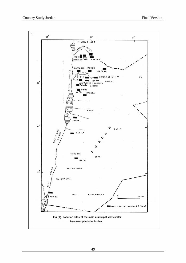
Country Study Jordan Final Version
49

Country Study Jordan Final Version
Table 1 shows the main municipal wastewater treatment plants in Jordan and the used
type of treatment. Due to limited efficiency of stabilization ponds as indicated by their
effluents BOD5 Valves (Table 2) MOWI started a program to replace them by other types of
treatment plant within this program Madabe stabilization pond treatment plant was replaced
in the year 2002 by a mechanical activated sludge treatment plant
Science other WWTP were quantitatively overloaded due to increases in the
population members as a result of natural growth and of forced migration into the country as
well as due to increases in the members of house connections. Table 3 shows the design
capacities of WWTP in Jordan and the amounts of wastewater reaching them. From that table
it can be deduced that Irbid, Karak, Baqa'a, Khirbet-es-Samra, Madaba, Ramtha and to some
extent Maan wastewater treatment plants are quantitatively overloaded None the less, the
effluents of some of them such as Irbid and Baqaa are producing an effluent wilh low BOD5
values. But, stabilization ponds whether quantitatively under loaded or over loaded produce
effluents generally with high BOD5 values of 83 mg/l up to 400 mg/l. With the exception of
Karah and Kufranja WWTP all activated sludge and biofilters WWTP produce effluents with
BOD5 Valves of less than 50 mg/l.
This shows that stabilization ponds treatment has not proven to be effective in Jordan.
Table 1: Main municipal treatment plants in Jordan and the types of treatment processes
Activated sludge Biofiltralion Stabilization ponds
Salt Jarash Abu Nusseir Irbid Fuheis/ Mahis Wadi Arab
Kark Tafila Kufranja Baqa'a
Khirbed-es-samra Aqaba Madaba* Ramtha Maan Mafraq Wadi sir
* Madaba (WWTP) was replaced by a mew plant of activated sludge type of treatment
50

Country Study Jordan Final Version
Table 2: Average biochemical characteristics of the effluents of the main municipal
wastewater treatment Plants (WWTP) in Jordan (WAJ 2001). "all values in mg/l"
WWTP BOD5 COD TSS TDS NH4 PO4
Salt 30 136 143 935 28 14 Jarash 33 177 95 1144 75 39 Abu Nusseir 14.4 73 43 980 1 16 Irbid 44 237 96 993 90 20 Fuheis/Mahis 24.4 103 53 820 23 9 Wadi arab 13.5 73 53 1059 2 11 Karak 101 302 97 900 71 13 Tafila 45.1 391 91 851 45 15 Kofrauja 89 368 257 1002 82 16 Baqa'a 48.5 183 151 1192 14.6 13 Khirbet-es-samra 102 247 173 1246 73 16 Aqaba 91.3 485 210 993 44 9 Madaba 400 854 190 1626 96 15 Ramtha 197 1718 516 1216 159 - Maan 83.5 482 190 1141 65 17 Mafraq 156 406 155 1153 100 13 Wadis sir 36.4 142 72 949 70 10 Table 3: Design capacities of WWTP in Jordan and their in flow loads
WWTP Design capacity m3/day Inflows m3/day (2001) Salt 7700 3400 Jarash 3500 2070 Abu Nusseir 4000 1620 Irbid 1100 4610 Fuheis/mahis 2400 1220 Wadi arab 22000 5990 Karak 785 1230 Tafila 1600 710 Kufranja 1900 1890 Baqaa 4000 11185 Khirbet-es-samra 68000 170750 Aqaba 9000 8800 Madaba 2000 4270 Ramtha 1920 2340 Maan 1670 1890 Mafraq 1800 1850 Wadi sir 4000 1110 Total mcm/yr 82.6
51

Country Study Jordan Final Version
IV. Institutional and Legal Framework
In Jordan three governmental agencies are involved in the management of the water sector,
each of them with a variety of primary responsibilities: The Ministry of Water and Irrigation,
the Water Authority of Jordan and the Jordan Valley Authority. The two authorities are
headed by Secretary Generals who report to the Minister of Water and Irrigation. The three
agencies are subject to the provisions of the Civil Service commission, the Audit Bureau, the
Bureau of Supervision and inspection and Government procurement regulations.
Ministry for Water and Irrigation
The Ministry for Water and Irrigation (MWI) was established in accordance with
Article 120 of the Constitution under by-law no. 54 of 1992. This regulation provides for the
formal organisational structure of the Ministry rather than setting out its formal roles and
responsibilities. The MWI supervise two Authorities, namely the Water Authority of Jordan
(WAJ) and the Jordan Valley Authority (JVA). The responsibilities of the Ministry, however,
are set out in Art.5 of the WAJ law, which states that the Ministry is responsible for all water
and wastewater systems and related projects and shall set forth a water policy and submit it to
the Council of Ministers for approval. The key functions actually undertaken by MWI
include:
Drafting and preparation of water sector policy;
Water resources data collection and management, including preparation of the
national water plan and advice on specific water abstraction proposals;
Donor financing liaison;
Management of large ‘strategic’ projects, particularly where international financing or
PSP is involved; and
Water sector legislation.
Water Authority of Jordan
52

Country Study Jordan Final Version
The Water Authority of Jordan (WAJ) was established under the Water Authority of
Jordan Law (No.18 of 1988) as an autonomous statutory body with financial and
administrative independence (Art.3). This provides WAJ with the authority to enter legal
proceedings, raise loans and sign contracts in its own right. WAJ is required to follow the
rules that are binding on ministries, governmental authorities and official authorities (Article
4). Its staff is employed under the Civil Service Law (Article 13). As an autonomous
statutory body, WAJ has its own financial accounts and the law requires that these be
organised according to recognised accounting methods and shall be audited by qualified
auditors (Article 18).
The following summarises WAJ’s responsibilities under Art.6 of the WAJ law:
Survey different water resources and determine ways, means and priorities for their
implementation and use (except for irrigation);
Set up plans and programs to implement approved water policies related to domestic
and municipal water (i.e. supplied through public networks) and sanitation, including
developing water resources, treating and desalinating water;
Direct and regulate the construction of public and private wells, license well drilling
rigs and drillers;
Study, design, construct and operate wastewater projects;
Draw terms, standards and special requirements in relation to the preservation of
water and water basins, protect them from pollution;
Carry out theoretical and applied research regarding water and wastewater;
Issue permits to engineers and licensed professionals to perform water and wastewater
works;
Regulate the uses of water, prevent its waste and conserve its consumption.
53

Country Study Jordan Final Version
Additional responsibilities can be conferred on WAJ by the Council of Ministers, upon
the recommendation of the Minister for Water and Irrigation (Art.7). WAJ is established with
a Board of Directors, chaired by the Minister for Water and Irrigation. Under Art.10, the
Board’s responsibilities may be summarised as:
Setting forth a water policy for the Kingdom;
Approving the water policy of the Kingdom and plans for the development and
conservation of water resources;
Submitting draft regulations to the Council of Ministers for approval;
Obtaining loans, with the approval of the Council of Ministers;
Making recommendations to the Council of Ministers concerning water tariffs; and
Investing WAJ’s funds and revenues, with the approval of the Council of Ministers.
The Secretary-General of WAJ, as Chief Executive of WAJ, is responsible for implementing
WAJ’s policies and plans and its day-to-day administration. The Secretary-General is
responsible to the Minister for Water and Irrigation (Art.12).
Under Art.28, the Council of Ministers, on the recommendation of the Minister for Water and
Irrigation, may assign any of the Authority’s duties or projects to any other body from the
public or private sector or to a company owned totally by the Authority. This may include
transfers of project management, a lease or ownership.
54

Country Study Jordan Final Version
The Jordan Valley Authority
Development in the Jordan Valley is governed by Law 19/1988, an extension of
Temporary Low 18/ 1977 that created the JVA as the successor to four organisations
previously responsible foe the overall development of the Jordan Valley. The 1988 low gives
the JVA the legal mandate for developing the Jordan Valley and the area south of the Dead
Sea. The responsibilities of the JVA are:
Development of water resources for domestic, irrigation and industrial uses in the
Jordan Valley area. Development of towns and villages.
Design and construction of road networks, domestic water supply electricity and
telecommunication networks and provision of tourist facilities.
Implement social development infrastructure such as schools, health centers, housing
government buildings, streets, parking lots etc.
Provide agriculture support services such as packing and grading stations, marketing
centers, processing factories, laboratories etc.
According the Law, the JVA will hand over projects to the appropriate regional or municipal
authorities after the projects are completed. The Law describes the Authority as an
autonomous corporate body with full authority in the allocation or usage of all surface and
groundwater resources and authorization to fix water prices.
V. Reuse Standards
55

Country Study Jordan Final Version
Standard JS 893:2002
Introduction
The Institution for Standards and Metrology is the national entity responsible for
Issuing standards in Jordan. Standards are set by technical committees formulated by The
Institution for Standards and Metrology from members representing main parties concerned
with the subject. All concerned parties have the right to express their opinion and comments
on the final draft of the subject standard during the notification period in order to make the
Jordanian standards in harmony with international standards, to alleviate any technical
boundaries facing trade and to facilitate flow of commodities between countries. Based on
this, the permanent technical committee for water and wastewater No.17 has set the Jordanian
Standard 893/1995 dealing with “Water-Reclaimed Domestic Wastewater” and
recommended its approval as a Jordanian Technical base No. 893/2002 in accordance with
article (11) paragraph (b) of the Standards and Metrology Law No. 22 for the year 2000.
Water: Reclaimed Domestic Wastewater
1. Scope
This Jordanian standard is purposely set to specify the conditions that the reclaimed domestic
wastewater discharged from wastewater treatment plants should meet in order to be
discharged or used in the various fields mentioned in this standard.
2. Standard References
The following standard references become conditions of this standard when referenced.
When a documented reference is dated, the amendments after that date do not apply despite
the fact that any contractual party depending on these references recommends using the latest
edition of the listed references. In the case that the reference is not dated then the latest
edition would prevail.
The library at the Institute for Standards and Metrology contains current standards.
-Standard Methods for the Examination of Water and Wastewater APHA. 1998
-Health Guidelines for the Use in Agriculture and Aquaculture, WHO. 1989.
3. Definition
56
Country Study Jordan Final Version
The following definitions are used for the purpose of this standard:
3-1 Domestic wastewater
Is the water produced from domestic usages and it could contain industrial wastewater that
comply in terms of quality to the ordinance issued by the official parties for the connection to
the public sewer system.
3-2 Reclaimed Water
Is the treated wastewater to be reused according to the conditions of this standard provided it
is not mixed with water from other sources.
3-3 landscape Areas
Is the green areas intended to be used for decoration and landscaping and not for recreational
purposes.
3-4 Mechanical Treatment Systems
Systems that use mechanical processes for treating water such as the activated sludge system,
the rotating biological contactors system, the biological filters system, and others.
3-5 Natural Treatment Systems
Systems that use natural processes for treating water by using aerobic or anaerobic ponds,
maturation ponds or others.
3-6 Disinfection
Is a process for the removal or reduction of pathogenic and indicator microorganisms that can
be found in the water by using disinfectants such as chlorine or chlorine dioxide or ultraviolet
rays or the ozone or any other disinfectant approved by the official parties.
3-7 Industrial Crops
Crops used for industrial purposes such as wood trees and olive trees
3-8 Field Crops
57

Country Study Jordan Final Version
Crops that are planted on large areas and harvested once a year and includes:
3-8-1 Forages
Crops planted in order to utilize its vital aggregate (stems and roots) such as berseem, sweet
corn, sudan grass, Alfa Alfa, …..
3-8-2 Grains
Crops planted for its high content of carbohydrate and used in the nutrition of humans and
animals and includes wheat, barely, oats, corn (white).
3-8-3 Legumes
Crops planted to utilize its seeds after drying such as lintel. Fenugreek and lupine.
3-8-4 Fibers
Crops planted in order to utilize its fibers such as cotton and linseed.
3-8-5 Oils
Crops planted to produce oil such as sesame, soya bean and olives.
3-8-6 Sugar
Crops planted to produce sugar such as sugar beet and sugarcane.
3-9 Cooked Vegetables
Vegetables that are usually eaten after cooking and includes: eggplant, squash, beans,
cornflower, potato, okra, pees, broad beans, turnip, spinach, jew’s mallow, artichoke.
3-10 Uncooked Vegetables
Vegetables that are usually eaten raw and includes the following: tomato, cucumber,
Egyptian cucumber, pepper, cabbage, onion, carrot, radish, lettuce, parsley, mint, rocket
(watercress), coriander, purslane, strawberry, watermelon and cantaloupe.
4. General Requirements:
4-1 The Reclaimed Domestic Wastewater standard has two primary components
a) Reclaimed water discharged to streams, wadis or water bodies.
b) Reclaimed water for reuse.
4-2. Reclaimed water must comply with the conditions stated in this standard for each of its
planned end uses.
58

Country Study Jordan Final Version
4-3 It is not permitted to dilute or mix reclaimed water discharged from wastewater treatment
plants with pure water intentionally to comply with the requirement set in this standard.
4-4 Should reclaimed water be used for purposes other than those mentioned in this standard
(such as for cooling or for fire distinguishing), special standards or guidelines are to be
applied in each case after conducting the necessary studies taking into consideration the
health and environmental dimension.
4-5 Official and specialized concerned parties overseeing the operation and development of
wastewater treatment plants must always work towards improving the effluent quality to
levels, maybe, exceeding those presented in this standard to ideally use the reclaimed water
and protect the environment.
5. Standard Requirements:
5-1 Reclaimed Water to be discharged to streams, wadis or water bodies.
5-1-1 It is allowed to discharge reclaimed wastewater to streams or wadis or water bodies
when its quality complies with the properties and criteria mentioned in table (1) and it is
prohibited to discharge it into wadis draining to the gulf of Aqaba.
5-1-2 When reclaimed water passes on areas that are above or leading to ground water
aquifers, measures must be taken to prevent the leakage of the reclaimed water to ground
waters.
5-1-3 When discharging reclaimed water to streams, wadis or water bodies that are in direct
contact with the public it is preferred to use any of the suitable types of disinfectants to
protect the public health. When Chlorine is used, the free residual chlorine concentration
shall not exceed 1 mg/l.
5-1-4 Natural treatment plants are permitted to exceed the specified values for E Coli
numbers when water is discharged to wadis leading to storage dams where the water is stored
59

Country Study Jordan Final Version
and used totally for irrigation purposes. In the event that this water is used prior to reaching
the dam, then the criteria specified for the reclaimed wastewater for the purpose of reuse and
according to the nature of the end use must be applied.
5-1-5 Table 1 – Allowable limit for properties and criteria for discharge of water to
streams or wadis or water bodies
Parameters Abbreviation Unit Allowable Limit
Group A
Biological Oxygen
Demand
BOD5 mg/l 60*
Chemical Oxygen
Demand
COD mg/l 150**
Dissolved Oxygen DO mg/l >1
Total suspended solids TSS mg/l 60**
pH pH mg/l 6-9
Nitrate NO3 mg/l 45
Total Nitrogen T-N mg/l 70
Escherishia Coli E. coli
Most probable number or
colony forming unit/100
ml
1000
Intestinal Helminthes
Eggs
Intestinal
Helminthes
Eggs
egg/l < or =1
Fat and grease FOG mg/l 8.0
Table 1. Continued
60

Country Study Jordan Final Version
Parameters Abbreviation Unit Allowable Limit
Group B
Phenol Phenol mg/l <0.002
Detergent MBAS mg/l 25
Total Dissolved Solids TDS mg/l 1500
Total Phosphate T-PO4 mg/l 15
Chloride Cl mg/l 350
Sulfate SO4 mg/l 300
Bicarbonate HCO3 mg/l 400
Sodium Na mg/l 200
Magnesium Mg mg/l 60
Calcium Ca mg/l 200
Sodium Adsorption
Ration
SAR - 6.0
Aluminium Al mg/l 2.0
Arsenic As mg/l 0.05
Berelium Be mg/l 0.1
Copper Cu mg/l 0.2
Floride F mg/l 1.5
Iron Fe mg/l 5.0
Lithium Li mg/l 2.5
Manganese Mn mg/l 0.2
61
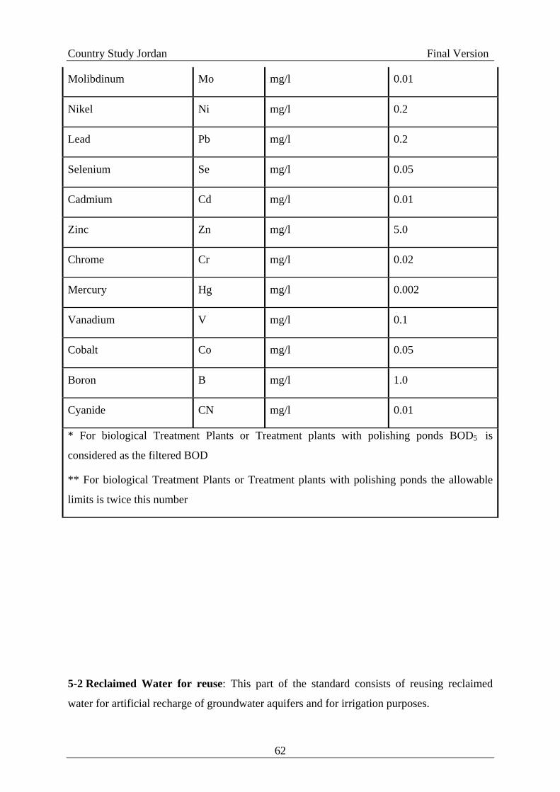
Country Study Jordan Final Version
Molibdinum Mo mg/l 0.01
Nikel Ni mg/l 0.2
Lead Pb mg/l 0.2
Selenium Se mg/l 0.05
Cadmium Cd mg/l 0.01
Zinc Zn mg/l 5.0
Chrome Cr mg/l 0.02
Mercury Hg mg/l 0.002
Vanadium V mg/l 0.1
Cobalt Co mg/l 0.05
Boron B mg/l 1.0
Cyanide CN mg/l 0.01
* For biological Treatment Plants or Treatment plants with polishing ponds BOD5 is
considered as the filtered BOD
** For biological Treatment Plants or Treatment plants with polishing ponds the allowable
limits is twice this number
5-2 Reclaimed Water for reuse: This part of the standard consists of reusing reclaimed
water for artificial recharge of groundwater aquifers and for irrigation purposes.
62
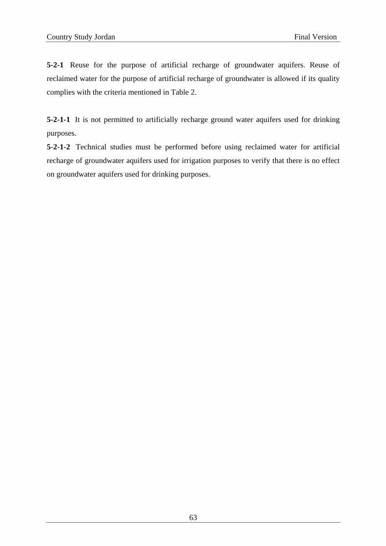
Country Study Jordan Final Version
5-2-1 Reuse for the purpose of artificial recharge of groundwater aquifers. Reuse of
reclaimed water for the purpose of artificial recharge of groundwater is allowed if its quality
complies with the criteria mentioned in Table 2.
5-2-1-1 It is not permitted to artificially recharge ground water aquifers used for drinking
purposes.
5-2-1-2 Technical studies must be performed before using reclaimed water for artificial
recharge of groundwater aquifers used for irrigation purposes to verify that there is no effect
on groundwater aquifers used for drinking purposes.
63

Country Study Jordan Final Version
Table 2 – Allowable Limit for properties and criteria for use in artificial groundwater
aquifers
Parameters Abbreviation Unit Allowable Limit
Group A
Biological Oxygen
Demand
BOD5 mg/l 15
Chemical Oxygen
Demand
COD mg/l 50
Dissolved Oxygen DO mg/l >2
Total suspended solids TSS mg/l 50
pH pH mg/l 6 – 9
Turbidity NTU 2
Nitrate NO3 mg/l 30
Ammonia NH4 5.0
Total Nitrogen T-N mg/l 45
Escherishia Coli E. coli
Most probable number or
colony forming unit/100
ml
<2.2
Intestinal Helminthes
Eggs
Intestinal
Helminthes
Eggs
Egg/l < or =1
Fat and grease FOG mg/l 8.0
64

Country Study Jordan Final Version
Table 2. Continued
Group B
Phenol Phenol mg/l <0.002
Detergent MBAS mg/l 25
Total Dissolved Solids TDS mg/l 1500
Total Phosphate T- PO4 mg/l 15
Chloride Cl mg/l 350
Sulfate SO4 mg/l 300
Bicarbonate HCO3 mg/l 400
Sodium Na mg/l 200
Magnesium Mg mg/l 60
Calcium Ca mg/l 200
Sodium Adsorption Ration SAR mg/l 6.0
Aluminium Al - 2.0
Arsenic As mg/l 0.05
Berelium Be mg/l 0.1
Copper Cu mg/l 0.2
Floride F mg/l 1.5
Iron Fe mg/l 5.0
Lithium Li mg/l 2.5
Manganese Mn mg/l 0.2
Molibdinum Mo mg/l 0.01
65
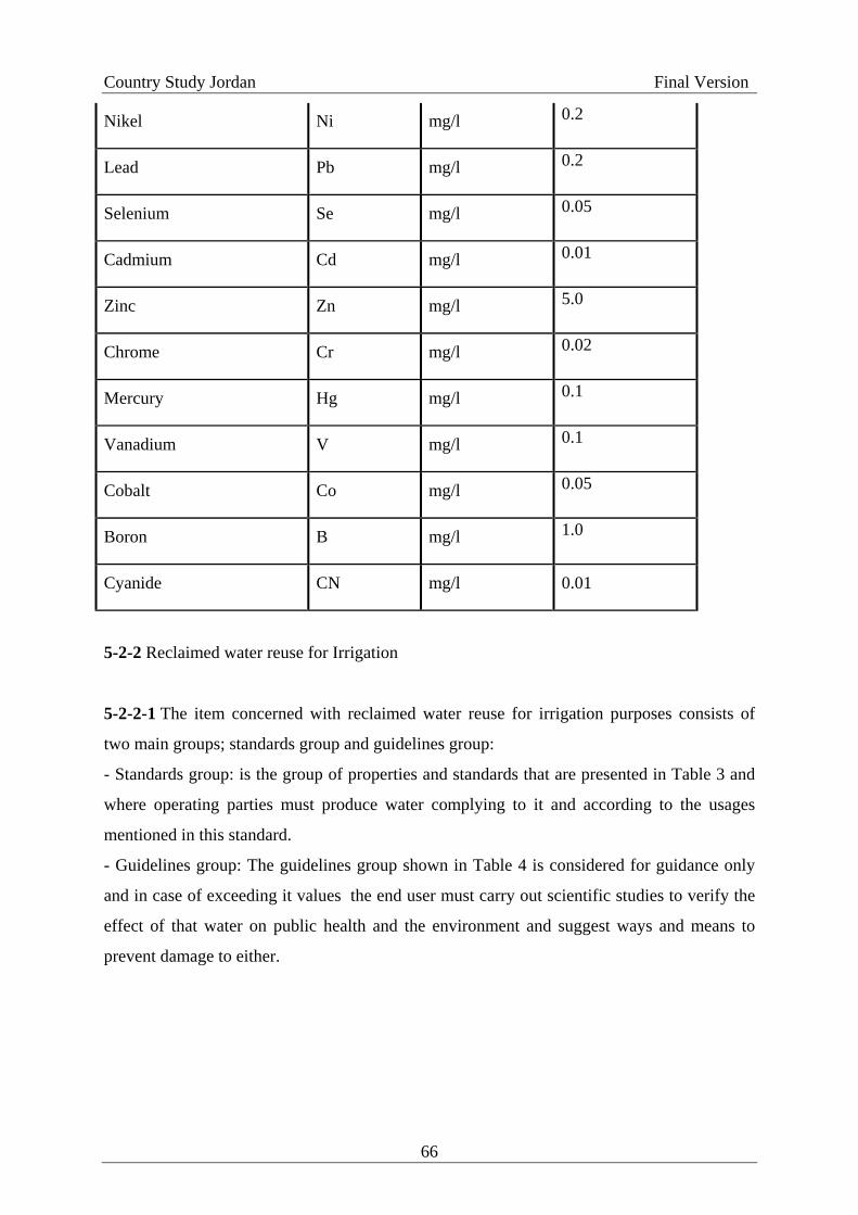
Country Study Jordan Final Version
Nikel Ni mg/l 0.2
Lead Pb mg/l 0.2
Selenium Se mg/l 0.05
Cadmium Cd mg/l 0.01
Zinc Zn mg/l 5.0
Chrome Cr mg/l 0.02
Mercury Hg mg/l 0.1
Vanadium V mg/l 0.1
Cobalt Co mg/l 0.05
Boron B mg/l 1.0
Cyanide CN mg/l 0.01
5-2-2 Reclaimed water reuse for Irrigation
5-2-2-1 The item concerned with reclaimed water reuse for irrigation purposes consists of
two main groups; standards group and guidelines group:
- Standards group: is the group of properties and standards that are presented in Table 3 and
where operating parties must produce water complying to it and according to the usages
mentioned in this standard.
- Guidelines group: The guidelines group shown in Table 4 is considered for guidance only
and in case of exceeding it values the end user must carry out scientific studies to verify the
effect of that water on public health and the environment and suggest ways and means to
prevent damage to either.
66

Country Study Jordan Final Version
5-2-2-2 It is prohibited to use reclaimed water for irrigating vegetables that are eaten
uncooked (raw).
5-2-2-3 It is prohibited to use sprinkler irrigation except for irrigating golf courses and in
that case irrigation should practiced at night and the sprinklers must be of the movable type
and not accessible for day use.
5-2-2-4 When using reclaimed water for irrigating fruit trees, irrigation must be stopped two
weeks prior to fruits harvesting and any falling fruits in contact with the soil must be
removed.
67

Country Study Jordan Final Version
Table 3 – Allowable Limit for properties and criteria for reuse in irrigation
Allowable limits per end use
Parameter Unit Cooked
Vegetables,
Parks,
Playgrounds
and Sides of
Roads within
city limits
Fruit Trees,
Sides of
Roads
outside city
limits, and
landscape
Field Crops,
Industrial
Crops and
Forest Trees
A B C
Biological Oxygen
Demand
mg/l 30 200 300
Chemical Oxygen
Demand
mg/l 100 500 500
Dissolved Oxygen mg/l >2 - -
Total suspended solids mg/l 50 150 150
pH unit 6-9 6-9 6-9
Turbidity NTU 10 - -
Nitrate mg/l 30 45 45
Total Nitrogen mg/l 45 70 70
Escherishia Coli Most
probable
number or
colony
forming
unit/100 ml
100 1000 -
68

Country Study Jordan Final Version
Intestinal Helminthes
Eggs
Egg/l < or = 1 < or = 1 < or = 1
Table 4 – Guidelines for Reuse in Irrigation
Group B
Fat And grease FOG mg/l 8
Phenol Phenol mg/l <0.002
Detergent MBAS mg/l 100
Total Dissolved Solids TDS mg/l 1500
Total Phosphate T-PO4 mg/l 30
Chloride Cl mg/l 400
Sulfate SO4 mg/l 500
Bicarbonate HCO3 mg/l 400
Sodium Na mg/l 230
Magnesium Mg mg/l 100
Calcium Ca mg/l 230
Sodium Adsorption
Ration
SAR - 9
Aluminium Al mg/l 5
Arsenic As mg/l 0.1
Berelium Be mg/l 0.1
Copper Cu mg/l 0.2
69
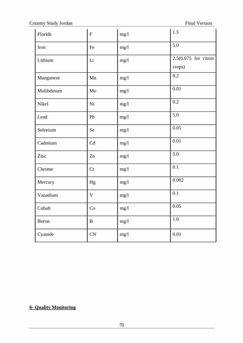
Country Study Jordan Final Version
Floride F mg/l 1.5
Iron Fe mg/l 5.0
Lithium Li mg/l 2.5(0.075 for citrus
crops)
Manganese Mn mg/l 0.2
Molibdinum Mo mg/l 0.01
Nikel Ni mg/l 0.2
Lead Pb mg/l 5.0
Selenium Se mg/l 0.05
Cadmium Cd mg/l 0.01
Zinc Zn mg/l 5.0
Chrome Cr mg/l 0.1
Mercury Hg mg/l 0.002
Vanadium V mg/l 0.1
Cobalt Co mg/l 0.05
Boron B mg/l 1.0
Cyanide CN mg/l 0.01
6- Quality Monitoring
70

Country Study Jordan Final Version
6-1 The Wastewater Treatment Plant Owner Party must ensure that the reclaimed water
quality complies to the standards and according to its end use. And must carry out the
required laboratory tests and document results in official logbooks and present them
whenever requested by the governmental monitoring parties.
6-2 The operating party must take composite samples every 2 hr for a period of 24 hrs in
accordance with the frequency indicated in Table 5. Monitoring parties can collect samples
in any way found suitable.
6-3 The frequency of collecting samples for both the operating and monitoring parties is as
indicated in Table 5.
6-4 Collecting, preserving, transporting and analyzing samples will be as stated in the
Standard Methods for the Examination of Water and Wastewater issued by APHA and the
federal American Association for Water Research and Pollution Control and any of its
amendments or any other approved method if it is not mentioned in the above mentioned
reference.
6-5 For natural treatment plants or for mechanical treatment plants with polishing ponds
BOD5 is calculated after filtration step.
6-6 In evaluating the quality of reclaimed water geometric mean is used for calculation of
Thermotolerant coliforms or Escherichia coli results.
6-7 In evaluating the content of reclaimed water for total Nitrogen, the Geometric mean is
used provided that at least 5 samples are included in the calculation.
6-8 Results of the Thermotolerant coliforms can replace those of the Escherichia coli when
the Escherichia coli test cannot be performed due to the absence of technical capabilities.
6-9 When there is a need to define a standard value for a criterion not mentioned in this
Standard then the Institution for Standards and Metrology must be contacted to take the
proper action.
71

Country Study Jordan Final Version
6-10 In case of epidemics the monitoring and operational parties must investigate the
presence of intestinal pathogenic microorganisms that may be found in the water.
7- Evaluation Mechanism
7-1 For the purpose of evaluating the quality of reclaimed water as per the different uses
mentioned in this standard the periods shown in Table 5 are approved.
7-2 When any value violate the standards set for discharge of reclaimed water to streams,
wadis or water bodies an extra-confirmatory sample must be taken. If the two samples
exceeded the allowable standard limits the concerned party will be notified in order to
conduct the necessary correction measures in the shortest possible time. And if the violation
persist for more than 3 months then the reuse of reclaimed water for that purpose should be
stopped until the water quality stabilized.
72

Country Study Jordan Final Version
Table 5 - Number of Reclaimed Water Samples to be collected for the purpose of
quality control and evaluation, and the required chemical, physical and biological
analysis to be done on the samples
Treatment
Plants
Sampling Frequency
Type Operating Party Monitoring Party
Evaluation
Period
Mechanical · Routine Tests: 8
samples / month (composite)
· Physical & Chemical
Properties: 3 samples /day
(grab)
· Intestinal Helminthes
Eggs: 4 samples/month
(composite)
· Escherichia coli: 8
samples/month (grab)
· Routine Tests: 2
samples/month
· Physical & Chemical
Properties: 2 samples /month
· Intestinal Helminthes
Eggs: 2 samples /month
· Escherichia coli: 2
samples /month
3 months*
Natural · Routine Tests: 4
samples / month (composite)
· Physical & Chemical
Properties: 3 samples /day
(grab)
· Intestinal Helminthes
Eggs: 2 samples/month
(composite)
· Escherichia coli: 4
samples/month (grab)
· Routine Tests: 1
samples / month
· Physical & Chemical
Properties: 1 samples /month
· Intestinal Helminthes
Eggs: 1 samples/month
· Escherichia coli: 1
samples/month
6 months**
73

Country Study Jordan Final Version
Table 5 – (Cont’d)
· Routine Tests: T-N, NH4, TSS, COD, BOD5, NO3
· Physical & Chemical Properties: pH, DO, RCL2, Turbidity, Temperature
* According to seasons (Dec – Feb) , (Mar – May), (Jun – Aug), (Sep – Nov)
** Winter and Summer (Summer: Start of May – Oct, Winter: Start of Nov – Apr)
VI. Public Awareness
74

Country Study Jordan Final Version
Informing and educating water users in Jordan about the seriousness of
water scarcity is a very important issue to overcome severe water shortage
problem. Public awareness program should include all the public sectors starting
from household, business and farm level. The program should include
protection of water quality as well as rationalizing water consumption. The
government believes that the public should be aware of the water scarcity and
shortages so that any significant changes in water conservation and protection
will be appreciated. In addition new legislations and laws can be enforced more
easily.
In view of the above it is believed that the Jordanian Ministry of Water
and Irrigation is the best institution to execute such a program and achieve the
government objectives through direct involvement of the people within the
program.
An active program had been designed and put in practice where policy
implications are related primarily to how the Government will collaborate with
non-governmental and other organizations at policy level. Furthermore, the
other part of the program is an educational campaign put into effect to inform
the public about the value of water for them and for the well being of the
country for the sustainability of life, and for the economic and social
development. Likewise facts, about water in Jordan need to be disseminated
such as the cost incurred provide the service, and the mounting pressure of the
population growth on the water resources. Economic measures may be adopted
to reinforce public awareness.
The Public Awareness program includes significant community outreach
where a forum is to be created between the organizations within the ministry of
75

Country Study Jordan Final Version
Water and Irrigation trained staff and the community stakeholders where they
can share and resolve local scale water issues. This forms as a link between the
central government and local communities. The trained staff from the ministry
has been involved in meetings with local community representatives to discuss
water issues at various watersheds. The community stakeholders
(representatives) were identified and are engaged in meetings addressing
specific issues related to individual watersheds. This will provide a community
based perspective on potential mitigation measures and pin point specific
concerns each community they might have.
To disseminate public awareness various materials are used including:
Newsletter articles
Citizen guidebooks
More newspaper coverage for water issues
TV and Radio
Websites
Creating public educational places in libraries and town halls
Developing signs in public areas
Educating land-use decision makers
Schools and universities
Developing and funding educational programs is the responsibility of the
government, but stakeholder agencies should share some responsibility for
education. The educational program is broadly based to the public but it
contains also issues addressing specific audiences for specific issues.
VI. References List
76

Country Study Jordan Final Version
Abu-Zir, M. (1989): Hydrochemistry and hydrogeology of the central part of Wadi Araba.
M. Sc. Thesis, University of Jordan, Amman.
ACSAD, (1980): The Arab Center for the Studies of Arid Zones and Dry Lands, Water
Resources of the Hamad Basin, Damascus (Arabic).
Bender, F. (1968): Geologie von Jordanien; Beitr. Z. region. Geol. d. Erde 7, XI, Hannover,
Gebrüder Bornträger Publ. Co.
Department of Meteorology: Publications and files of the Department of
Meteorology/Amman.
El-Naqa, A. R. (1989): Hydrogeochemistry of groundwater resources in the area between
Wadi El-Yabis and Yarmouk River/Jordan Valley area, Unpubl. M. Sc. Thesis, University of
Jordan, Amman.
El-Naser, H. (1991): Groundwater resources of the deep aquifer system in NW Jordan -
Hydrogeological and hydrochemical quasi 3-dimensional modelling, Hydrogeology and
Umwelt, H.3, Wùrzburg, Germany.
Horowitz, A. (1979): The Qaternary of Israel, Academic Press, London.
Jordan Valley Authority: Open files of the Jordan Valley Authority/Amman.
Neev, D. and Emery, D. O. (1967): The Dead Sea depositional processes and environments
of evaporites, Ministry of Development, Geol. Survey of Israel, 41, 147p., Jerusalem.
NWMP (1977): National Water Master Plan of Jordan, 8 vol. Hannover, Bundesanstalt für
Geowissenschaften und Rohstoffe, GTZ, Eschborn.
Parker, D. H. (1970): Investigation of the sandstone aquifers of East Jordan. UNDP, AGL:
SF/Jor. 9., Rome 1970.
77

Country Study Jordan Final Version
Salameh, E. & Udluft, P. (1985): The hydrodynamic pattern of central Jordan, Geol. Jb,
c38, Hannover.
Salameh, E. and Banayan, H. (1993): Water Resources of Jordan and their future
potentials. FES and RSCN, Amman
Shuraiki, Y. (1991): Impacts of biocides on ground and surface water pollution in Jordan, In
Water Pollution in Jordan, FES, 1991.
Standard Methods for the Examination of Water and Wastewater, APHA, 1998
Jordanian Standard No. (202/1991)
Stuart Pettygrove et al., (1984). Irrigation with Reclaimed Municipal Wastewater, guidance
Manual.
USAID/ARD, (2001) Standards, Regulations & Legislation for Water Reuse in Jordan
WHO, 1989. Health Guidelines for the USE of Wastewater in Agriculture and Aquaculture.
Water Authority of Jordan: Open files of the Water Authority of Jordan/Amman.
78
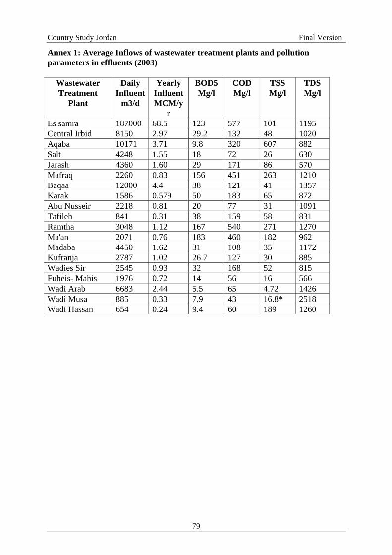
Country Study Jordan Final Version
Annex 1: Average Inflows of wastewater treatment plants and pollution parameters in effluents (2003)
Wastewater Treatment
Plant
Daily Influent
m3/d
Yearly Influent MCM/y
r
BOD5 Mg/l
COD Mg/l
TSS Mg/l
TDS Mg/l
Es samra 187000 68.5 123 577 101 1195 Central Irbid 8150 2.97 29.2 132 48 1020 Aqaba 10171 3.71 9.8 320 607 882 Salt 4248 1.55 18 72 26 630 Jarash 4360 1.60 29 171 86 570 Mafraq 2260 0.83 156 451 263 1210 Baqaa 12000 4.4 38 121 41 1357 Karak 1586 0.579 50 183 65 872 Abu Nusseir 2218 0.81 20 77 31 1091 Tafileh 841 0.31 38 159 58 831 Ramtha 3048 1.12 167 540 271 1270 Ma'an 2071 0.76 183 460 182 962 Madaba 4450 1.62 31 108 35 1172 Kufranja 2787 1.02 26.7 127 30 885 Wadies Sir 2545 0.93 32 168 52 815 Fuheis- Mahis 1976 0.72 14 56 16 566 Wadi Arab 6683 2.44 5.5 65 4.72 1426 Wadi Musa 885 0.33 7.9 43 16.8* 2518 Wadi Hassan 654 0.24 9.4 60 189 1260
79