water resources and management overview - … · water resources and management overview – namoi...
TRANSCRIPT

Leading policy and reform in sustainable water management
Water resources and management overviewNamoi catchment

Publisher
NSW Office of Water
Level 17, 227 Elizabeth Street GPO Box 3889 Sydney NSW 2001
T 02 8281 7777 F 02 8281 7799
www.water.nsw.gov.au
The NSW Office of Water is a separate office within the Department of Environment, Climate Change and Water. The Office of Water manages the policy and regulatory frameworks for the State’s surface water and groundwater resources to provide a secure and sustainable water supply for all users. The Office of Water also supports water utilities in the provision of water and sewerage services throughout New South Wales.
Water resources and management overview: Namoi catchmentFebruary 2011
ISBN 978 1 74263 158 5
This report may be cited as:
Green D., Petrovic J., Moss P., Burrell M. (2011) Water resources and management overview: Namoi catchment, NSW Office of Water, Sydney
Cover photo: Namoi River upstream of Wee Waa (courtesy of Dayle Green)
© State of New South Wales through the Department of Environment, Climate Change and Water, 2011
This material may be reproduced in whole or in part for educational and non-commercial use, providing the meaning is unchanged and its source, publisher and authorship are clearly and correctly acknowledged.
Disclaimer: While every reasonable effort has been made to ensure that this document is correct at the time of publication, the State of New South Wales, its agents and employees, disclaim any and all liability to any person in respect of anything or the consequences of anything done or omitted to be done in reliance upon the whole or any part of this document.
Maps: The maps are to be used as a general guide for regional and local scale natural resource planning and management only, not for the assessment of specific sites which can only be assessed by investigation specific to those sites.
The maps are published by the NSW Office of Water. While every reasonable effort has been made to ensure the accuracy of the information contained in the maps, you should only satisfy yourself as to the accuracy of the information before relying on it.
NOW 10_377

Water resources and management overview – Namoi catchment
Contents
1 Introduction.................................................................................................................................... 1
2 Climate .......................................................................................................................................... 4
2.1 Rainfall ................................................................................................................................ 4
2.2 Evaporation ......................................................................................................................... 5
3 Land use........................................................................................................................................ 6
4 Environment .................................................................................................................................. 8
4.1 Native vegetation ................................................................................................................ 8
4.2 Parks and reserves ............................................................................................................. 8
4.3 Wetlands ............................................................................................................................. 9
4.4 Significant biodiversity ...................................................................................................... 10
5 Surface water .............................................................................................................................. 11
5.1 Upper Namoi River............................................................................................................ 11
5.2 Peel River.......................................................................................................................... 12
5.3 Keepit Dam to Narrabri ..................................................................................................... 12
5.4 Lower Namoi ..................................................................................................................... 13
5.5 Stream flow characteristics ............................................................................................... 14
6 Groundwater................................................................................................................................ 17
7 River operations and management ............................................................................................. 20
7.1 Major storages and regulating structures ......................................................................... 20
7.2 Licensed water use ........................................................................................................... 22
Peel River surface water................................................................................................... 22
Peel River groundwater .................................................................................................... 23
Namoi River surface water................................................................................................ 23
Namoi River groundwater use .......................................................................................... 24
7.3 Water sharing plans .......................................................................................................... 25
Combined water sharing plans ......................................................................................... 26
Regulated surface water sharing plans ............................................................................ 27
Unregulated surface water sharing plans ......................................................................... 27
Groundwater sharing plans............................................................................................... 28
Plans in preparation .......................................................................................................... 29
8 References .................................................................................................................................. 30
i | NSW Office of Water, February 2011
Water resources and management overview – Namoi catchment
ii | NSW Office of Water, February 2011
Tables Table 1: Land use statistics for the Namoi catchment .......................................................................... 6
Table 2. Threatened aquatic species of the Namoi catchment ........................................................... 10
Table 3: Mean daily flow for selected Namoi gauge sites ................................................................... 14
Table 4: Major storages of the Namoi catchment ............................................................................... 21
Table 5: Peel Regulated River water entitlements as at 30 June 2010 .............................................. 23
Table 6: Peel catchment groundwater share component as at 1 July 2010 ....................................... 23
Table 7: Namoi Regulated River share components as at 30 June 2010........................................... 24
Table 8: Namoi catchment groundwater entitlements (2009) ............................................................. 25
Figures Figure 1: The Namoi catchment ............................................................................................................ 2
Figure 2: The Peel catchment ............................................................................................................... 2
Figure 3: Topography and elevation of the Namoi catchment .............................................................. 3
Figure 4: Average annual rainfall in the Namoi catchment ................................................................... 4
Figure 5: Average monthly rainfall at Gunnedah................................................................................... 4
Figure 6: Class A pan average annual evaporation in the Namoi catchment ....................................... 5
Figure 7: Mean daily pan evaporation at Gunnedah ............................................................................. 5
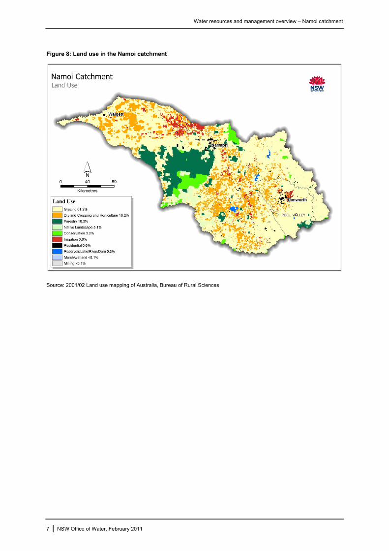
Figure 8: Land use in the Namoi catchment.......................................................................................... 7
Figure 9: Annual flows in the Namoi River at Gunnedah 1892-2010.................................................. 15
Figure 10: Daily flow histogram and cumulative deviation from the mean for Namoi River at Gunnedah.......................................................................................................................... 16
Figure 11: Groundwater aquifer types in the Namoi/Peel ................................................................... 18
Figure 12: Groundwater Management Areas in the Namoi catchment............................................... 18
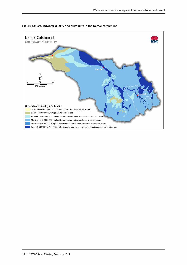
Figure 13: Groundwater quality and suitability in the Namoi catchment ............................................. 19
Water resources and management overview – Namoi catchment
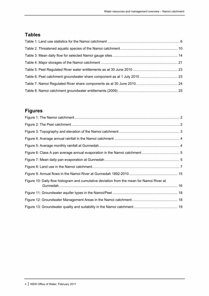
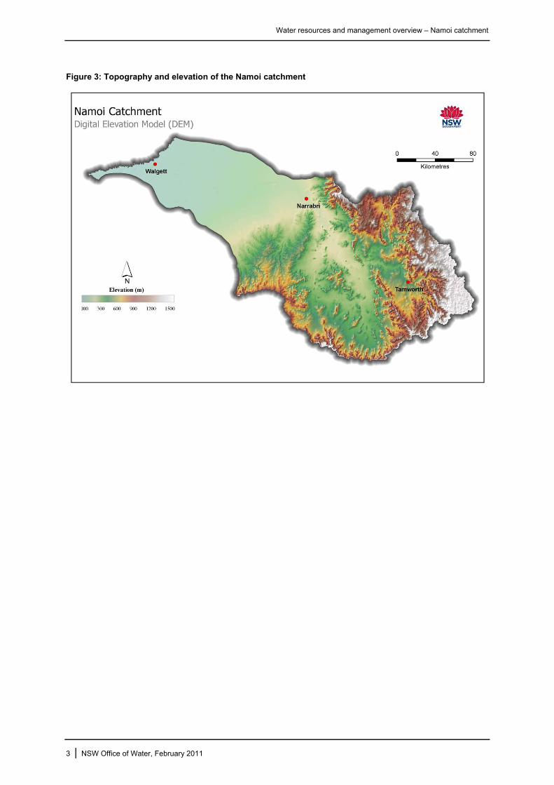
1 Introduction The Namoi River is one of the Murray-Darling Basin’s major NSW sub-catchments. It covers a total
area of about 42,000 km2 from the Great Dividing Range near Tamworth to the Barwon River near Walgett (Figure 1). The Peel River is a major regulated tributary to the Namoi with a catchment area of around 4,700 km2 (Figure 2). It contributes an average annual volume of approximately 280,000 ML to
the Namoi River.
The Namoi catchment borders the Gwydir and Castlereagh catchments and is bounded by the Great Dividing Range in the east, the Liverpool Ranges and Warrumbungle Ranges in the south, and the
Nandewar Ranges and Mount Kaputar to the north. Elevations range from over 1,500 m to the south and east to just 100 m on the alluvial floodplain of the lower catchment west of Narrabri (Figure 3). Stretching from Bendemeer in the east to Walgett on the western boundary, the Namoi catchment is
over 350 km long.
Major tributaries of the Namoi River include Coxs, Creek and the Mooki, Peel, Manilla, and McDonald Rivers joining the Namoi upstream of Boggabri with Pian, Narrabri, Baradine and Bohena Creeks
joining below Boggabri. Major tributaries of the Peel River are Goonoo Goonoo Creek, Cockburn River, and Dungowan Creek. Streamflows in the Namoi catchment are regulated by Keepit Dam on the Namoi River, Split Rock Dam on the Manilla River and Chaffey Dam on the Peel River. The
regulated section of the Peel River has historically been managed as a separate allocation scheme to the Namoi regulated river, and operationally the management of Chaffey Dam is independent of the other storages on the Namoi.
The annual regional output is over $1 billion, with dryland and irrigated agricultural production representing approximately half this amount. Major industries include cotton, livestock production, grain and hay, poultry, horticulture and forestry. The regions local councils also depend on the Namoi and
Peel Rivers to meet the urban water requirements of many of the regions urban centres with the most notable being the major urban centre of Tamworth whose water supply is provided from the Peel River.
Prior to European settlement in the mid-1800s the Namoi and Peel catchments were occupied by the
Kamilaroi people. Today, approximately 100,000 people live within the Namoi catchment, mostly along the Namoi River and its tributaries between Tamworth and Narrabri. Tamworth, located on the Peel River, is the largest urban centre in the catchment with a population of nearly 33,500 people living in
town. Gunnedah, on the Namoi River, has a population of 7,500 people, and Narrabri, also on the Namoi, has a population of 6,100 people. A number of smaller towns throughout the catchment, such as Barraba, Manilla, Quirindi, Walgett, Wee Waa and Werris Creek, support between 1,000 and 3,000
people.
Peel River at Taroona upstream of Chaffey Dam
1 | NSW Office of Water, February 2011

Water resources and management overview – Namoi catchment
Figure 1: The Namoi catchment
Figure 2: The Peel catchment
2 | NSW Office of Water, February 2011
Water resources and management overview – Namoi catchment
Figure 3: Topography and elevation of the Namoi catchment
3 | NSW Office of Water, February 2011

Water resources and management overview – Namoi catchment
2 Climate
2.1 Rainfall
Annual average rainfall varies over the Namoi catchment, from a maximum of 1,300 mm over the ranges in the east to around 400 mm near Walgett (Figure 4). The pattern of rainfall varies throughout
the year with the highest monthly rainfall at Gunnedah occurring in summer, and the lowest rainfall occurring from April though September.
Figure 4: Average annual rainfall in the Namoi catchment
Source: Hutchinson and Kesteven 1998
Figure 5: Average monthly rainfall at Gunnedah
Source: Bureau of Meteorology Climate Data Online
4 | NSW Office of Water, February 2011
Water resources and management overview – Namoi catchment
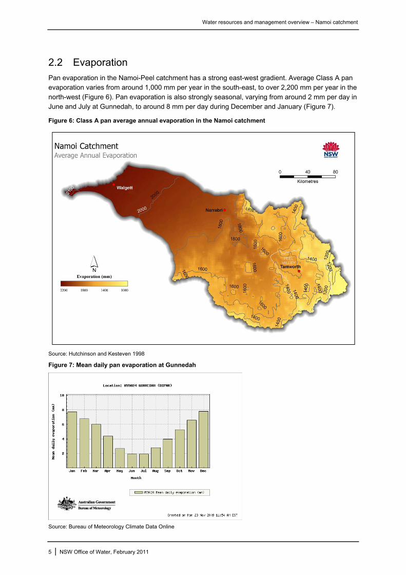
2.2 Evaporation
Pan evaporation in the Namoi-Peel catchment has a strong east-west gradient. Average Class A pan evaporation varies from around 1,000 mm per year in the south-east, to over 2,200 mm per year in the
north-west (Figure 6). Pan evaporation is also strongly seasonal, varying from around 2 mm per day in June and July at Gunnedah, to around 8 mm per day during December and January (Figure 7).
Figure 6: Class A pan average annual evaporation in the Namoi catchment
Source: Hutchinson and Kesteven 1998
Figure 7: Mean daily pan evaporation at Gunnedah
Source: Bureau of Meteorology Climate Data Online
5 | NSW Office of Water, February 2011

Water resources and management overview – Namoi catchment
6 | NSW Office of Water, February 2011
3 Land use The dominant land use in the Namoi catchment is sheep and cattle grazing which accounts for 61 per
cent of land use by area (Table 1). Wheat, cotton and other broad acre crops are grown along the alluvial floodplains (Figure 8). Of the 1,120 km2 irrigated in the year 2000, around 800 km2 (over 70 per cent) was used for cotton production in the Lower Namoi catchment (CSIRO 2007). The Peel
catchment supports around 66 km2 of irrigation, most of which is for irrigated pasture or fodder crops (NOW 2010).
Extensive areas of land for conservation and forestry occur in the middle of the catchment to the south
of Narrabri. Together with other native landscapes these land uses account for over 18 per cent of the catchment. Much of this area comprises the Pilliga Scrub, a significant area of remnant dry sclerophyll forest (see Section 4.2).
Table 1: Land use statistics for the Namoi catchment
Land use type Extent (km2) Proportion of catchment (%)
Grazing 25,727 61.2
Dryland cropping and horticulture 6,810 16.2
Forestry 4,339 10.3
Native landscapes 2,136 5.1
Conservation 1,351 3.2
Irrigation 1,259 3.0
Residential 256 0.6
Lakes, rivers, dams 139 0.3
Wetland 12 <0.1
Mining 7 <0.1
Source: 2001/02 Land use mapping of Australia, Bureau of Rural Sciences
Water resources and management overview – Namoi catchment
Figure 8: Land use in the Namoi catchment
Source: 2001/02 Land use mapping of Australia, Bureau of Rural Sciences
7 | NSW Office of Water, February 2011
Water resources and management overview – Namoi catchment
4 Environment The Namoi catchment supports a diversity of landscapes ranging from the Liverpool and Kaputar
ranges, through the rolling hills of the sedimentary slopes, to the open floodplains of the Liverpool Plains and Darling Riverine Plains in the western part of the catchment. The relatively young volcanic geology of the region and extensive alluvial floodplains derived from these materials results in very
productive heavy black and grey clays that are sought after for farming and irrigation. However, the impact of these activities resulted in more than 10 per cent of the Namoi catchment being moderately to severely eroded by the early 1990s (Namoi CMA 2006). The extent of erosion is now improving in
some areas due to reduced tillage farming practices.
4.1 Native vegetation
Much of the native vegetation in the Namoi catchment has been cleared for cropping on the lower slopes and floodplain, and for grazing on the upper slopes and tablelands. In 2002 the extent of native vegetation in the Namoi catchment was estimated at 62 per cent (Namoi CMA 2006). Throughout the
catchment, poor grazing practices over long periods have led to plant loss, weed invasion and degradation of soils (Cotton Catchment Communities CRC 2009). Grazing land, particularly on the western slopes and plains, still retains native grasses, but much of the overstorey has been removed
(Namoi CMA 2006).
Vegetation of the upper catchment ranges from open box woodlands on the slopes to temperate and subalpine forests in the ranges, and endangered native grasslands in the Liverpool Plains. Riverine
vegetation is dominated by river oaks and willows, with river red gums occurring along the major streams such as the Peel.
The floodplain of the Lower Namoi River is characterised by six broad vegetation communities (Cotton
Catchment Communities CRC 2009):
• Carbeen woodlands on flats and gentle slopes, often associated with ancient watercourses
• Riparian woodland (coolibah in association with river red gum or black box) on frequently
flooded areas of the floodplain
• Coolibah or black box woodland on higher areas of the floodplain
• Bimble box woodland on elevated floodplains and ridges
• River red gum forest and woodland along riverbanks and river flats
• Weeping myall (an acacia) on flats or gentle rises that are above inundation.
4.2 Parks and reserves
National parks and nature reserves protect over 3,200 km2 of native habitat within the Namoi catchment (NOW GIS, National Parks layer). Most of this area is associated with the slopes and ranges of the catchment, and there is very little riverine or floodplain land under conservation.
In the upper catchment, Warrabah National Park protects around 40 km2 along the banks of the Namoi River, about 80 km east of Tamworth. Scenic granite boulders, deep gorges and river rapids are a feature of the park. The hill slopes support woodlands of white cypress pine, hill red gum and Caley's
ironbark while tall stands of river oak, teatree and bottlebrush line the river banks.
To the east of Narrabri, Mount Kaputar National Park covers 502 km2 of volcanic mountain ranges that drain to Maules Creek and other nearby tributaries. The park protects a range of vegetation
communities including isolated patches of rainforest in sheltered locations, a variety of forest habitats ranging from semi-arid to subalpline, and heathland on the high plateaus and peaks.
8 | NSW Office of Water, February 2011

Water resources and management overview – Namoi catchment
Pilliga Nature Reserve is located around 80 km south-west of Narrabri in the upper catchment of Bohena Creek, and is the largest conservation area in the catchment. The reserve protects 805 km2 of semi-arid woodland known as the Pilliga Scrub, with an additional 1,056 km2 protected as state
conservation area. Together with adjacent areas of forest managed by Forests NSW, the Pilliga Scrub is the largest remaining dry sclerophyll forest west of the Great Dividing Range in NSW (NPWS 2002).
Vegetation of the Pilliga Scrub is dominated by ironbark woodland, with small areas of Blakely’s red
gum, yellow box, white box and angophora. White cypress and black cypress are commonly associated with the ironbark. The large size of the reserve and its connection to adjacent forest makes it an important habitat for a wide range of threatened species including the endemic Pilliga mouse,
eastern pygmy possum, koala, glossy black-cockatoo, regent honeyeater, turquoise parrot, brush-tailed rock wallaby, red-necked wallaby and swamp wallaby (DECCW 2009).
4.3 Wetlands
While the Namoi catchment does not contain any extensive wetland complexes, a feature of the river downstream of Narrabri is the many small lagoons, wetlands, and anabranches, as well as extensive areas of floodplain woodlands and high level flood runners that occur on the lower Namoi floodplain.
Green and Dunkerley (1992) mapped 184,000 hectares of wetlands (including 143,000 hectares of coolibah woodlands) during the first wetland survey of the valley in 1992. A more recent survey of wetlands (Eco Logical Australia 2008) mapped a total of 2,766 wetlands in the valley totalling 46,398
hectares. Of these, 1,829 were identified as natural wetlands and 937 were artificial wetlands (dams, weir pools and other storages). The study found that nearly half of the wetlands in the catchment would be inundated by a 1 in 2 year flood event.
The catchment also contains a number of significant wetlands that are independent of the river system. The largest of these is Lake Goran, a large internal drainage basin south of Gunnedah that covers more than 60 km2. The lake is rarely full, however in recent years the deepest part of the lake
has been semi-permanent due to the diversion of local creeks by agricultural activities and structural works (Banks 1995). The lakebed is intensively cropped when dry, but when flooded the lake provides habitat for large numbers of waterbirds, and for this reason is listed as a wetland of national
significance (DEWHA 2008).
Landry Lagoon near Gunnedah
9 | NSW Office of Water, February 2011
Water resources and management overview – Namoi catchment
4.4 Significant biodiversity
The aquatic and terrestrial environments of the Namoi catchment provide habitat for a large number of threatened species and ecological communities that are protected under the Threatened Species
Conservation Act 1995.
There are 28 threatened plant species, with 11 of these being listed as endangered. There are also 66 threatened animal species found within the catchment, including four species of amphibians, nine
bats, 37 birds, 11 mammals and five reptiles.
There are 12 endangered ecological communities, and some of these are particularly significant within the Namoi catchment. Originally one of the few natural grassland areas in Australia, the Liverpool
Plains has now been converted almost wholly for cultivation. Listing of the Native vegetation on cracking clay soils on the Liverpool Plains endangered ecological community is designed to ensure protection for remnants of the original native grasses of the area which includes plains grass,
Queensland bluegrass and coolibah grass.
The endangered ecological community Coolibah-Black box woodland of the northern riverina plains in the Darling Riverine Plains and Brigalow Belt South bioregions occurs on the floodplain of the lower
Namoi River. Typically occurring as open grassy woodlands, this community has been extensively cleared for cropping or modified through grazing. It is thought that around two-thirds of the original extent of this community within NSW has been cleared (NSW Scientific Committee 2004). Other
endangered ecological communities include Myall woodlands and Inland grey box woodlands, both known to occur in the Liverpool Plains, Pilliga and lower Namoi regions.
Four aquatic species that previously occurred within the Namoi catchment are listed as threatened
under the NSW Fisheries Management Act 1994. These are the river snail, silver perch, purple spotted gudgeon, and the olive perchlet, which is listed as an endangered population (Table 2).
The aquatic community of the Namoi River forms part of the endangered ecological community known
as the aquatic ecological community in the natural drainage system of the lowland catchment of the Darling River. This community includes 21 native fish species and hundreds of native invertebrate species that are found within the Darling River and its associated streams, wetlands and anabranches
within NSW. These include the Barwon-Darling channel, its intermittent northern tributaries, and the regulated tributaries to the south including the Namoi. The community occurs in lowland riverine environments with meandering channels and a variety of aquatic habitats including deep channels and
pools, wetlands, gravel beds and floodplains.
Table 2. Threatened aquatic species of the Namoi catchment
Common name Scientific name NSW status
River snail Notopala sublineata Endangered
Silver perch Bidyanus bidyanus Vulnerable
Purple spotted gudgeon Mogurnda adspersa Endangered
Olive perchlet Ambassis agassizii Endangered population
Aquatic ecological community in the natural drainage system of the lowland catchment of the Darling River
Endangered ecological community
10 | NSW Office of Water, February 2011

Water resources and management overview – Namoi catchment
5 Surface water The Namoi River flows in a westerly direction from its headwaters in the Great Dividing Range. Its
main tributary, the Peel River, joins the Namoi near Gunnedah. The Peel River originates in the south-east of the catchment near its border with the Hunter Valley, and flows in a north-west direction towards the Namoi River. The Peel is regulated by Chaffey Dam which provides water for irrigation as
well as supplementing the water supply for the city of Tamworth (in addition to Dungowan Dam on Dungowan Creek).
Other major tributaries of the Namoi River include the Manilla and McDonald Rivers upstream of
Keepit Dam, Coxs Creek and the Mooki River, which join the Namoi upstream of Boggabri, and Pian, Narrabri, Baradine and Bohena Creeks joining below Boggabri. The Namoi River then flows westerly across the plains and joins the Barwon River near Walgett. The Pian Creek and Gunidgera Creek
system is an anabranch of the Namoi River which flows from the northern side of the river near Wee Waa in a westerly direction and rejoins the Namoi upstream of Walgett.
5.1 Upper Namoi River
The Namoi River above Keepit Dam rises in the Great Dividing Range to the south-east of Tamworth. There are three major tributaries – the Manilla River (with Split Rock Dam), the Macdonald River and
Halls Creek – as well as numerous smaller creeks. The rivers rise at elevations over 1000 m, falling to 400 m where the Upper Namoi and Manilla Rivers meet near Manilla. In these reaches the water flows within well-defined channels and the river only has a limited floodplain.
The Macdonald River at Woolbrook
11 | NSW Office of Water, February 2011
Water resources and management overview – Namoi catchment
5.2 Peel River
The Peel River catchment covers about 11 per cent of the Namoi catchment. The Peel River joins the Namoi River a short distance downstream of Keepit Dam.
The river starts in the Great Dividing Range south of Tamworth and includes the major catchments of the Upper Peel River (including Chaffey Dam), Cockburn River, and Goonoo Goonoo Creek. The upper reaches of the Peel River flow through narrow valleys to the Cockburn River junction with the
river broadening into wide alluvial floodplains below Tamworth. Caroll Gap is considered the end of the regulated Peel system. Around 40 per cent of the annual discharge in the Peel River at Caroll Gap is contributed by the Cockburn River, while Goonoo Goonoo and Dungowan Creeks both contribute
approximately 10 per cent (NOW 2010).
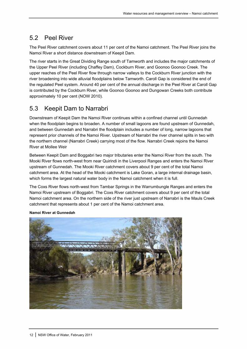
5.3 Keepit Dam to Narrabri
Downstream of Keepit Dam the Namoi River continues within a confined channel until Gunnedah when the floodplain begins to broaden. A number of small lagoons are found upstream of Gunnedah, and between Gunnedah and Narrabri the floodplain includes a number of long, narrow lagoons that
represent prior channels of the Namoi River. Upstream of Narrabri the river channel splits in two with the northern channel (Narrabri Creek) carrying most of the flow. Narrabri Creek rejoins the Namoi River at Mollee Weir
Between Keepit Dam and Boggabri two major tributaries enter the Namoi River from the south. The Mooki River flows north-west from near Quirindi in the Liverpool Ranges and enters the Namoi River upstream of Gunnedah. The Mooki River catchment covers about 9 per cent of the total Namoi
catchment area. At the head of the Mooki catchment is Lake Goran, a large internal drainage basin, which forms the largest natural water body in the Namoi catchment when it is full.
The Coxs River flows north-west from Tambar Springs in the Warrumbungle Ranges and enters the
Namoi River upstream of Boggabri. The Coxs River catchment covers about 9 per cent of the total Namoi catchment area. On the northern side of the river just upstream of Narrabri is the Mauls Creek catchment that represents about 1 per cent of the Namoi catchment area.
Namoi River at Gunnedah
12 | NSW Office of Water, February 2011
Water resources and management overview – Namoi catchment
5.4 Lower Namoi
Narrabri is considered to be the start of the true riverine zone of the Namoi catchment due to the increased frequency of lagoons, the low gradient of the channel and the development of several
anabranches and effluent channels. There are large numbers of lagoons in this reach, although most are small and require overbank flooding for inundation (Green and Dunkerley 1992). Two major weirs downstream of Narrabri – Mollee Weir and Gunidgera Weir – regulate water for irrigation, stock and
domestic users in the lower Namoi. A third weir, Weeta Weir, is not operational and therefore not used as a re-regulatory weir.
Pian Creek is the largest effluent of the Namoi River, and leaves the river just upstream of Wee Waa.
Under natural conditions, water entered the creek only when flows in the Namoi River were high. Pian Creek is now regulated to supply irrigation water to properties along its length and there are many private weirs and off-creek storages. Water is diverted into the system from the Namoi River via
Gunidgera Weir into Gunidgera Creek, and then into Pian Creek. When flows are sufficient, Pian Creek travels for over 200 km westward before it joins the Namoi River just 20 km upstream of its confluence with the Barwon River. Pian Creek receives local runoff from two small tributaries – The
Sink Hole and Old Burren Creek.
Gunidgera Creek leaves the Namoi River at Gunidgera Weir and rejoins the river near Cuttabri, some 100 km downstream. The creek is regulated to supply water for irrigation, stock and domestic
purposes. As with Pian Creek, there are many small instream storages which form artificial wetland habitat (Green and Dunkerley 1992).
To the south-west of Narrabri is a large area of low elevation. It includes Bohena, Coghill, Etoo and
Baradine Creeks plus many other minor water courses. Many of these have their origins in the dry, semi-arid Pilliga area which supports extensive areas of native forest. This area generally contributes little inflow under normal conditions. However, during wet times, significant flood inflows to the Namoi
River between Wee Waa and Walgett can be generated from this region.
Below Baradine Creek the lower reaches of the Namoi are characterised by multiple channels, and the occurrence of many small flood channels and lagoons alongside the river (Green and Dunkerley
1992). The capacity of the channel here is about half that of the channel at Narrabri. At the far end of the valley a number of flood runners, such as Two Mile Warrambool, break away from the river and carry water through to the Barwon River during high flows.
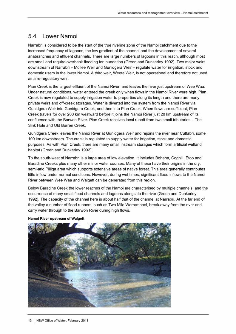
Namoi River upstream of Walgett
13 | NSW Office of Water, February 2011

Water resources and management overview – Namoi catchment
5.5 Stream flow characteristics
At the time of publication there are 68 active river gauges within the Namoi catchment recording flows on a continuous basis. Twenty-four of these are located within the Peel catchment. Table 3 shows
mean daily flows for some key locations.
The Namoi River maintains an average daily flow of 1,922 ML per day at Gunnedah. Downstream, flows decrease to around 1,500 ML per day due to the significant irrigation extractions and diversions
into effluent channels. The Macdonald River is the highest yielding of the upper tributaries per catchment area, contributing 2.5 times the daily flow of the Manilla River.
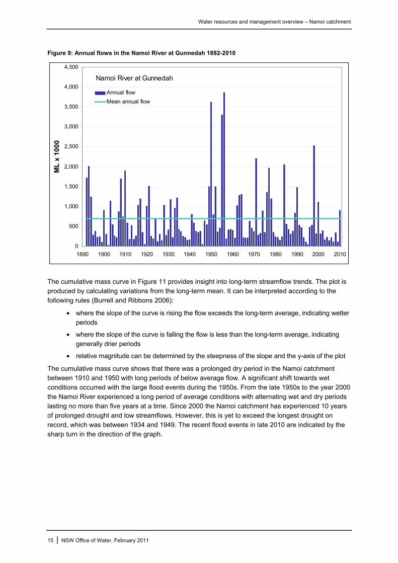
The long-term average annual flow in the Namoi River at Gunnedah is 696,000 ML. The lowest annual
flow occurred in 1902 when just 33,270 ML was recorded, while the highest annual flow occurred in 1956 with 3,871,300 ML recorded (Figure 9). The Namoi catchment experienced a prolonged drought with nine consecutive years of below average flow from 2001 to 2010.
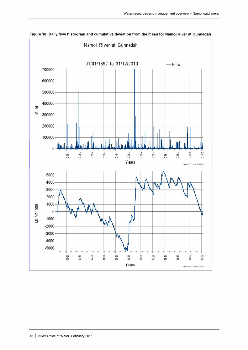
Daily streamflows provide an indication of the variability of flow patterns and the peak height of flood events. There have been several large floods in the Namoi River, the largest of these being in February 1955 when a peak height of 707,000 ML was recorded (Figure 10). Large floods in the order
of 200,000 ML have occurred on average once per decade since the 1950s. However, there has been no flood of this magnitude in the Namoi River since the year 2000. The most recent flooding occurred in August and December 2010 when peaks of 30,000 ML and 54,000 ML per day respectively were
recorded at Gunnedah.
Table 3: Mean daily flow for selected Namoi gauge sites
Gauge site Catchment area (km2)
Mean daily flow (ML)
Period of record
Namoi River at Manilla (upstream Keepit) 5,180
Namoi River d/s Keepit Dam 5,700 972 1924-2009
Namoi River at Gunnedah 17,100 1922 1891-2009
Narrabri Creek at Narrabri 25,120 1512 1891-2009
Namoi River d/s Gunidgera Weir 28,500 1364 1976-2009
Namoi River at Bugilbone 31,100 1569 1951-2009
Manilla River at Upper Manilla 1,795 165 1941-2009
MacDonald River at Retreat 1,760 435 1965-2009
Peel River at Carrol Gap 4,670 766 1923-2009
Mooki River at Breeza 3,630 296 1957-2009
Coxs Creek at Boggabri 4,040 231 1965-2009
Baradine Creek at Kienbri 2 1,000 38 1981-2009
Pian Creek at Waminda – 241 1972-2009
Gunidgera Creek d/s regulator – 323 1975-2009
Source: NSW Office of Water Real Time Data – Rivers and Streams
14 | NSW Office of Water, February 2011
Water resources and management overview – Namoi catchment
Figure 9: Annual flows in the Namoi River at Gunnedah 1892-2010
Namoi River at Gunnedah
0
500
1,000
1,500
2,000
2,500
3,000
3,500
4,000
4,500
1890 1900 1910 1920 1930 1940 1950 1960 1970 1980 1990 2000 2010
ML
x 1
00
0
Annual flow
Mean annual flow
The cumulative mass curve in Figure 11 provides insight into long-term streamflow trends. The plot is
produced by calculating variations from the long-term mean. It can be interpreted according to the following rules (Burrell and Ribbons 2006):
• where the slope of the curve is rising the flow exceeds the long-term average, indicating wetter
periods
• where the slope of the curve is falling the flow is less than the long-term average, indicating generally drier periods
• relative magnitude can be determined by the steepness of the slope and the y-axis of the plot
The cumulative mass curve shows that there was a prolonged dry period in the Namoi catchment between 1910 and 1950 with long periods of below average flow. A significant shift towards wet
conditions occurred with the large flood events during the 1950s. From the late 1950s to the year 2000 the Namoi River experienced a long period of average conditions with alternating wet and dry periods lasting no more than five years at a time. Since 2000 the Namoi catchment has experienced 10 years
of prolonged drought and low streamflows. However, this is yet to exceed the longest drought on record, which was between 1934 and 1949. The recent flood events in late 2010 are indicated by the sharp turn in the direction of the graph.
15 | NSW Office of Water, February 2011
Water resources and management overview – Namoi catchment
Figure 10: Daily flow histogram and cumulative deviation from the mean for Namoi River at Gunnedah
date:27/01/11 t im e:15:59:20.03
N amoi River at Gunnedah
01/01/1892 to 31/12/2010
0
100000
200000
300000
400000
500000
600000
700000
ML
/d
Y ears
1900
1910
1920
1930
1940
1950
1960
1970
1980
1990
2000
2010
Flow
date:27/01/11 t im e:16:00:26.37
-5000
-4000
-3000
-2000
-1000
0
1000
2000
3000
4000
5000
ML/
d*10
00
Y ears
1900
1910
1920
1930
1940
1950
1960
1970
1980
1990
2000
2010
o
16 | NSW Office of Water, February 2011

Water resources and management overview – Namoi catchment
17 | NSW Office of Water, February 2011
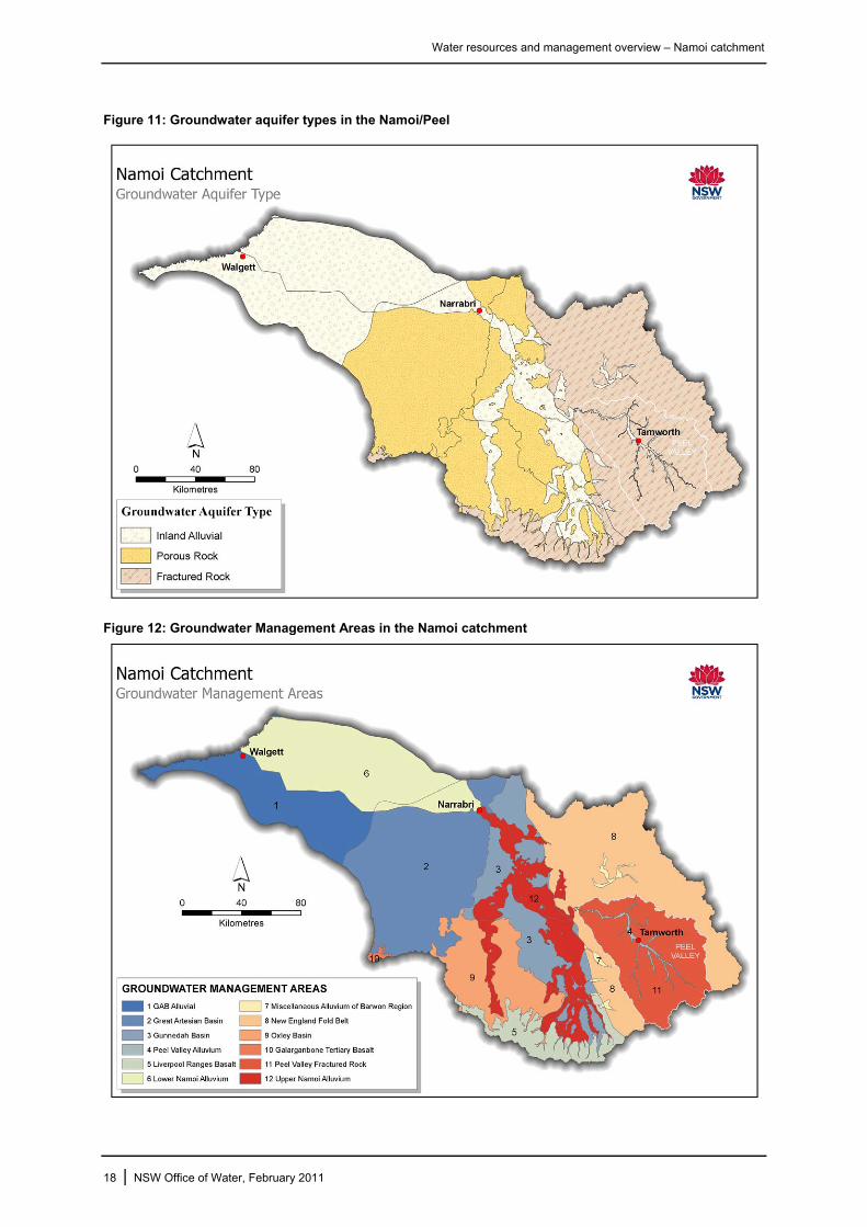
6 Groundwater Groundwater is contained in the unconsolidated sediments along the Namoi River and its major
tributaries. The alluvium of the Namoi River is by far the most important in the state in terms of groundwater use, providing water for stock use, domestic supplies, irrigation, industry and town water supplies (Figure 11).
The high-yielding aquifers of the Namoi catchment are managed as two groundwater resources – the Lower Namoi Groundwater Source and the Upper Namoi Groundwater Source, both of which are managed under a water sharing plan (see section 7.3).
The Lower Namoi Groundwater Source extends approximately 160 km west from Narrabri and covers an area of about 7,630 km2. The alluvium is up to 120 m deep and some bores yield more than 200 litres per second (WRC 1984).
The Upper Namoi Groundwater Sources extend about 175 km south from Narrabri and include the unconsolidated sediments associated with the Namoi River and its tributaries (including Mooki River and Coxs Creek) upstream of Narrabri. They cover an area of 3,800 km2, and are divided into 12
separate groundwater zones based on hydrogeological features (Figure 11). The alluvium of the Peel catchment is the most productive in this area, with yields as high as 40 litres per second, although the majority of bores yield 10-20 litres per second (WRC 1984).
The lower part of the catchment to the west of Narrabri is underlain by the aquifers of the Great Artesian Basin. This is one of the largest artesian basins in the world covering 1.7 million km2 or 22 per cent of Australia (Crabb 1997) and containing an estimated 8,700 million ML of artesian water
(Thoms et al. 2004). The aquifers of the Great Artesian Basin have high levels of sodium which make them unsuitable for irrigation use. However, the water from these aquifers is generally suitable for domestic and town water supply (GABCC 1998).
Widespread monitoring of groundwater levels in the Namoi catchment has been undertaken since the early 1970s. The NSW Office of Water monitors groundwater levels at 644 sites throughout the Upper and Lower Namoi Groundwater Sources (DWE 2009). Monitoring information has been used in the
development of groundwater models for the Lower Namoi, and some zones in the Upper Namoi. The models are computer-based representations of the hydrogeological systems, and are used to derive estimates of groundwater recharge, and to predict groundwater level behaviour.
Shallow aquifers that are highly connected to the river system are common in the Peel and Upper Namoi and as a result levels are highly dependent on surface water flows. As expected in these areas the quality of the water is high and suitable for most purposes. Water quality deteriorates towards the
western end of the catchment where groundwater quality is brackish to saline, and is sometimes too salty for stock (Figure 12). The NSW Office of Water has 54 monitoring bores in the Peel Alluvium, most of which were installed in the year 2000 (NOW 2010).
Water resources and management overview – Namoi catchment
Figure 11: Groundwater aquifer types in the Namoi/Peel
Figure 12: Groundwater Management Areas in the Namoi catchment
18 | NSW Office of Water, February 2011
Water resources and management overview – Namoi catchment
Figure 13: Groundwater quality and suitability in the Namoi catchment
19 | NSW Office of Water, February 2011
Water resources and management overview – Namoi catchment
7 River operations and management
7.1 Major storages and regulating structures
Keepit Dam was completed in 1960 as the major irrigation storage for the Namoi catchment (
Table 4). It also supplies town water for Walgett, provides for flood mitigation, and generates
hydropower through a six megawatt hydropower station operated by Eraring Energy.
Split Rock Dam on the Manilla River was completed in 1987 to augment the supply from Keepit Dam as well as suppling users along the Manilla River. The two dams are operated as a joint water supply
system for the Namoi catchment.
Chaffey Dam is approximately 45 km south-east of Tamworth and its prime purpose is to regulate the flow of the Peel River and augment water supply to Tamworth. In addition, Tamworth City Council
owns and operates Dungowan Storage where delivery of water is achieved via a pipeline from the storage to Tamworth.
To help with the distribution of water there are three weirs situated on the Namoi River downstream of
Narrabri. Mollee Weir has a storage capacity of 3,300 ML and is designed to hold and re-regulate flows to improve the precision with which water can be supplied along the lower valley.
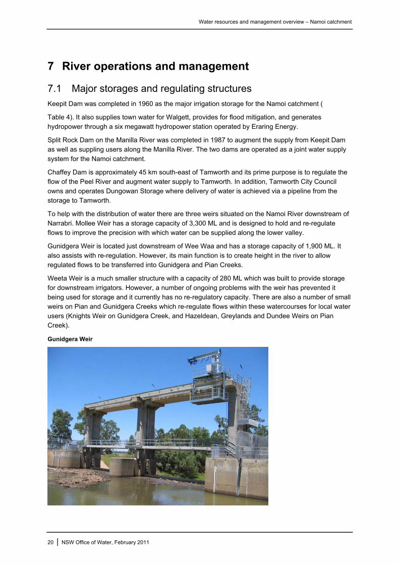
Gunidgera Weir is located just downstream of Wee Waa and has a storage capacity of 1,900 ML. It
also assists with re-regulation. However, its main function is to create height in the river to allow regulated flows to be transferred into Gunidgera and Pian Creeks.
Weeta Weir is a much smaller structure with a capacity of 280 ML which was built to provide storage
for downstream irrigators. However, a number of ongoing problems with the weir has prevented it being used for storage and it currently has no re-regulatory capacity. There are also a number of small weirs on Pian and Gunidgera Creeks which re-regulate flows within these watercourses for local water
users (Knights Weir on Gunidgera Creek, and Hazeldean, Greylands and Dundee Weirs on Pian Creek).
Gunidgera Weir
20 | NSW Office of Water, February 2011
Water resources and management overview – Namoi catchment
Table 4: Major storages of the Namoi catchment
Split Rock Keepit Chaffey Dungowan
River Manilla Namoi Peel Dungowan Ck
Capacity 397,000 ML 426,000 ML 62,000 ML 6,300 ML
Catchment area 1,650 km2 5,700 km2 420 km2 105 km2
Purpose Irrigation Irrigation Irrigation, Town water Town water
Nearest town Manilla Gunnedah Tamworth Tamworth
Split Rock Dam
Keepit and Chaffey Dams
21 | NSW Office of Water, February 2011
Water resources and management overview – Namoi catchment
7.2 Licensed water use
The Namoi catchment uses around 2.5 per cent of the total surface water diverted for irrigation in the Murray-Darling Basin, and around 15 per cent of the total groundwater resource that is extracted in the
Basin (CSIRO 2008).
The Namoi River and Peel River systems are operated separately from a water resource management perspective. The following outlines the major features of water use in both systems.
Peel River surface water
The Peel River system is operated (or regulated) to meet the water resource needs of Peel River water users including general security and high security irrigators, stock and domestic users and
Tamworth town water supply. Water from Chaffey Dam and Dungowan Dam is used to meet these needs. Dungowan Dam is owned and operated by Tamworth City Council in conjunction with their high security licensed river entitlement to meet the needs of Tamworth.
Licence holders in the Peel catchment are allocated water under an annual allocation system. Under this system water is put aside at the beginning of the defined water year (1 July in the Peel) for essential future requirements, delivery and storage losses. The remaining water held in storage is then
distributed to licence holders as allocation. Allocation increments may occur throughout the year (to 100 per cent) if available resources increase. Where possible tributary flows are utilised to meet water user demands before dam releases are made. Under this allocation system any water remaining in an
account at the end of the water year is forfeited.
The two major water users in the system are Tamworth City Council with an entitlement of 16,400 ML for town water supply, and general security irrigators who have an annual entitlement of 30,911 ML
(Table 5). During the sharing of the water from Chaffey Dam, a reserve is maintained to ensure the security of high security water users.
When flow in the river is in excess of water user and environmental needs, supplementary water
access is declared. This allows irrigators to pump river water without their annual entitlement being debited. General security irrigators are allowed to use up to a maximum of 100 per cent of their entitlement in any one water year.
Minimum environmental flow conditions are maintained downstream of Chaffey Dam, Dungowan Dam and at Carrol Gap. Excess water from the Peel catchment flows into the Namoi River and is utilised by Namoi water users where possible.
Water users situated on the various creeks and tributaries of the Peel catchment may also extract water with an unregulated water licence. These licences are subject to a range of access conditions that protect the health of the water courses such as cease-to-pump conditions. As of June 2010 the licensed
entitlement of unregulated water users in the Peel catchment was 17,708 megalitres (NOW 2010).
22 | NSW Office of Water, February 2011

Water resources and management overview – Namoi catchment
Table 5: Peel Regulated River water entitlements as at 30 June 2010
Access licence category Total share component (ML)
Domestic and stock 85
Domestic and stock (stock) 20
Domestic and stock (domestic) 72
General security 30,911
High security 801
High security (research) 3
Local water utility 16,400
TOTAL 48,292
Source: NSW Office of Water
Peel River groundwater
As of June 2010 there was over 62,000 ML of licensed groundwater entitlement within the Peel
catchment. Over 51,000 ML of this is being extracted from the alluvial aquifers while the remainder is associated with the fractured rock groundwater sources (Table 6). Nearly half of all groundwater use in the Peel catchment is for irrigation and another 40 per cent is used for stock watering. Water is
accessed through nearly 5,000 bores across the catchment. All groundwater licences in the Peel catchment are managed according to the recently commenced Peel water sharing plan (section 7.3).
Table 6: Peel catchment groundwater share component as at 1 July 2010
Total share component (ML) Access license category
Alluvial Fractured rock
Domestic and stock 266 619
Local water utility 530 100
Aquifer 18,379 9,975
Aquifer (general security) 32,206
TOTAL 51,381 10,694
Source: NSW Office of Water
Namoi River surface water
The Namoi River system is regulated to meet the needs of water users and the environment from Split
Rock Dam to its confluence with the Barwon-Darling River at Walgett. Split Rock Dam, Keepit Dam and the downstream re-regulating weirs are operated to meet water user needs with the tributary inflows from the Peel River, Mooki River, Coxs Creek and other tributaries utilised before dam
releases are made.
Split Rock Dam and Keepit Dam are operated in series, as a combined resource, with water transferred from Split Rock Dam to Keepit Dam as required and within environmental conditions.
Outlet capacity limitations for Keepit Dam may necessitate Split Rock Dam releases.
The Upper Namoi (Split Rock to Keepit) and Lower Namoi (Keepit to Walgett) are operated using different allocation methods. The Upper Namoi utilises annual accounting and requires full allocation
to be achieved before any additional storage is shared with the lower Namoi. The Lower Namoi is operated using a continuous accounting system. The main difference with continuous accounting is that there is no annual resetting of accounts or re-allocating of the resources for general security
23 | NSW Office of Water, February 2011
Water resources and management overview – Namoi catchment
licence holders. This effectively allows general security water users to operate their own accounts and usage patterns according to their individual requirements. The system currently allows for 200 per cent of their share component to be stored in their account, providing they do not use more than 125 per
cent in any water year, or more than 300 per cent in any three consecutive water years.
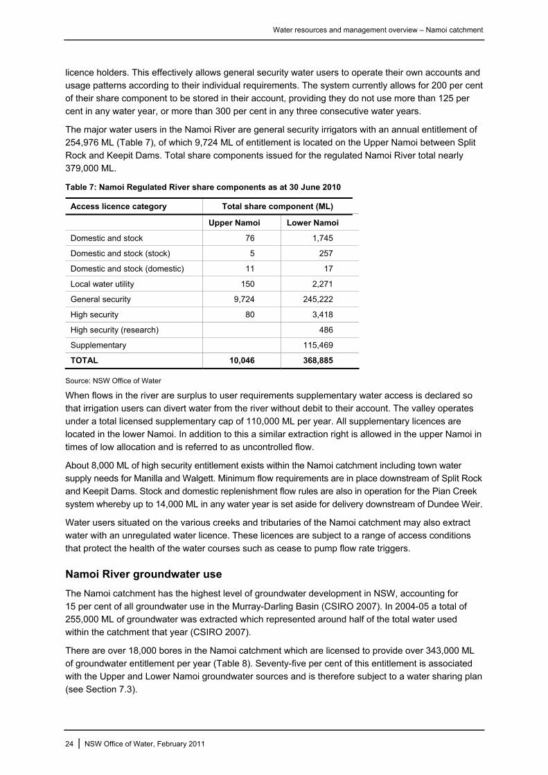
The major water users in the Namoi River are general security irrigators with an annual entitlement of 254,976 ML (Table 7), of which 9,724 ML of entitlement is located on the Upper Namoi between Split
Rock and Keepit Dams. Total share components issued for the regulated Namoi River total nearly 379,000 ML.
Table 7: Namoi Regulated River share components as at 30 June 2010
Access licence category Total share component (ML)
Upper Namoi Lower Namoi
Domestic and stock 76 1,745
Domestic and stock (stock) 5 257
Domestic and stock (domestic) 11 17
Local water utility 150 2,271
General security 9,724 245,222
High security 80 3,418
High security (research) 486
Supplementary 115,469
TOTAL 10,046 368,885
Source: NSW Office of Water
When flows in the river are surplus to user requirements supplementary water access is declared so that irrigation users can divert water from the river without debit to their account. The valley operates
under a total licensed supplementary cap of 110,000 ML per year. All supplementary licences are located in the lower Namoi. In addition to this a similar extraction right is allowed in the upper Namoi in times of low allocation and is referred to as uncontrolled flow.
About 8,000 ML of high security entitlement exists within the Namoi catchment including town water supply needs for Manilla and Walgett. Minimum flow requirements are in place downstream of Split Rock and Keepit Dams. Stock and domestic replenishment flow rules are also in operation for the Pian Creek
system whereby up to 14,000 ML in any water year is set aside for delivery downstream of Dundee Weir.
Water users situated on the various creeks and tributaries of the Namoi catchment may also extract water with an unregulated water licence. These licences are subject to a range of access conditions
that protect the health of the water courses such as cease to pump flow rate triggers.
Namoi River groundwater use
The Namoi catchment has the highest level of groundwater development in NSW, accounting for
15 per cent of all groundwater use in the Murray-Darling Basin (CSIRO 2007). In 2004-05 a total of 255,000 ML of groundwater was extracted which represented around half of the total water used within the catchment that year (CSIRO 2007).
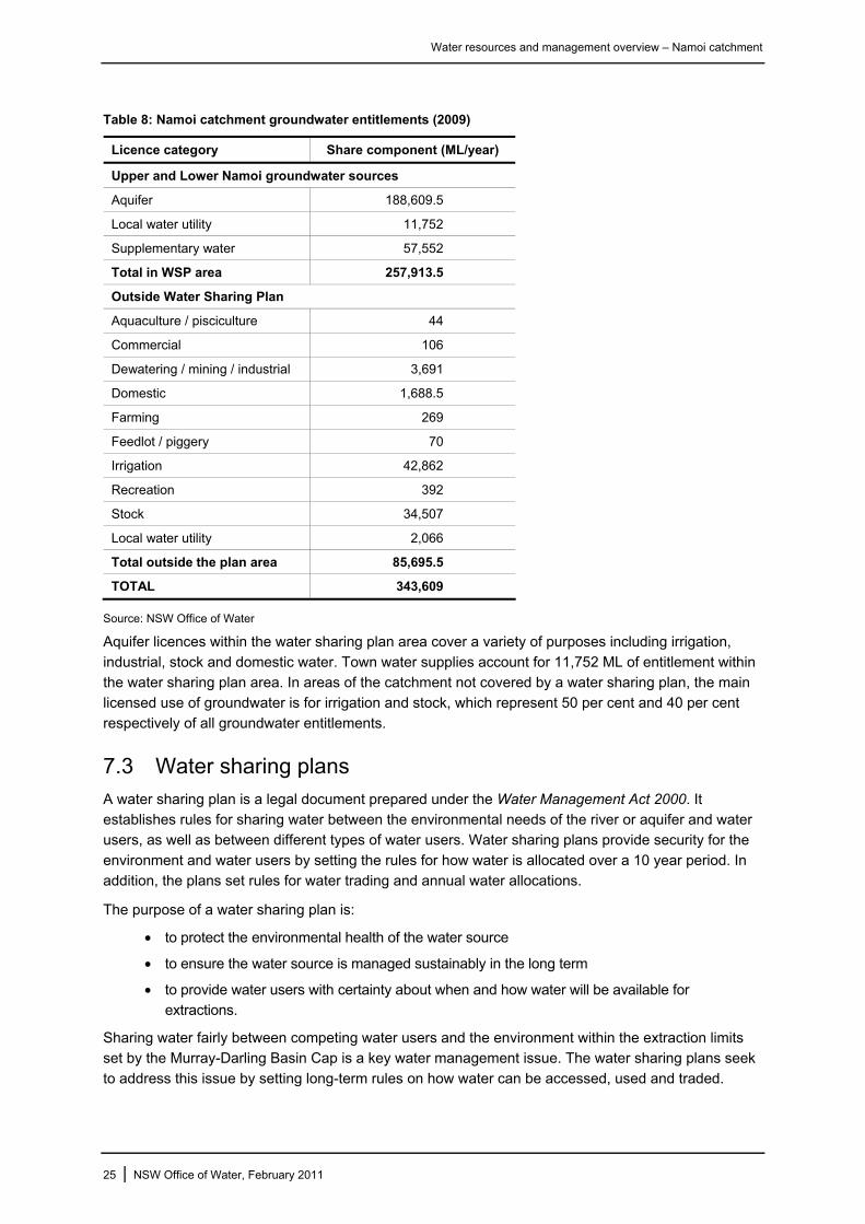
There are over 18,000 bores in the Namoi catchment which are licensed to provide over 343,000 ML of groundwater entitlement per year (Table 8). Seventy-five per cent of this entitlement is associated with the Upper and Lower Namoi groundwater sources and is therefore subject to a water sharing plan
(see Section 7.3).
24 | NSW Office of Water, February 2011
Water resources and management overview – Namoi catchment
Table 8: Namoi catchment groundwater entitlements (2009)
Licence category Share component (ML/year)
Upper and Lower Namoi groundwater sources
Aquifer 188,609.5
Local water utility 11,752
Supplementary water 57,552
Total in WSP area 257,913.5
Outside Water Sharing Plan
Aquaculture / pisciculture 44
Commercial 106
Dewatering / mining / industrial 3,691
Domestic 1,688.5
Farming 269
Feedlot / piggery 70
Irrigation 42,862
Recreation 392
Stock 34,507
Local water utility 2,066
Total outside the plan area 85,695.5
TOTAL 343,609
Source: NSW Office of Water
Aquifer licences within the water sharing plan area cover a variety of purposes including irrigation,
industrial, stock and domestic water. Town water supplies account for 11,752 ML of entitlement within the water sharing plan area. In areas of the catchment not covered by a water sharing plan, the main licensed use of groundwater is for irrigation and stock, which represent 50 per cent and 40 per cent
respectively of all groundwater entitlements.
7.3 Water sharing plans
A water sharing plan is a legal document prepared under the Water Management Act 2000. It establishes rules for sharing water between the environmental needs of the river or aquifer and water users, as well as between different types of water users. Water sharing plans provide security for the
environment and water users by setting the rules for how water is allocated over a 10 year period. In addition, the plans set rules for water trading and annual water allocations.
The purpose of a water sharing plan is:
• to protect the environmental health of the water source
• to ensure the water source is managed sustainably in the long term
• to provide water users with certainty about when and how water will be available for extractions.
Sharing water fairly between competing water users and the environment within the extraction limits set by the Murray-Darling Basin Cap is a key water management issue. The water sharing plans seek
to address this issue by setting long-term rules on how water can be accessed, used and traded.
25 | NSW Office of Water, February 2011
Water resources and management overview – Namoi catchment
Floodwaters however, remain an ongoing challenge as they play a vital role in sustaining and replenishing the landscape, but are also highly valued by local agricultural users. The management of these floodwaters is therefore an essential part of the surface water management.
There are currently two surface water sharing plans and two groundwater sharing plans active within the Namoi catchment, and one within the Peel catchment that covers both surface and groundwater. A further three groundwater sharing plans are in preparation.
A copy of any of the water sharing plans referred to in this section can be obtained from the NSW Office of Water website at www.water.nsw.gov.au
Combined water sharing plans
Peel Regulated, Unregulated, Alluvial and Fractured Rock Water Sources
The Water Sharing Plan for the Peel Regulated, Unregulated, Alluvial and Fractured Rock Water Sources commenced on 1 July 2010 and applies until 30 June 2020. The plan recognises that the
water resources of the Peel Valley are linked, and would therefore benefit from being managed collectively. The plan includes extraction from all surface water, connected alluvial and fractured rock aquifers in the Peel Valley. The water sources included in the plan are:
• Peel Regulated River Water Source
• five unregulated river water sources – Chaffey Water Source, Upper Peel River Tributaries Water Source, Goonoo Goonoo Creek Water Source, Cockburn River Water Source and
Lower Peel River Tributaries Water Source
• two groundwater sources, being the Peel Alluvium Water Source and the Peel Fractured Rock
Water Source.
The sum of the long-term average annual extraction limits (LTAEL) for all water sources within the water sharing plan is estimated to be 110,000 ML. At the commencement of the plan this provided for LTAEL for the Peel Regulated River Water Source of 15,100 ML, the Peel Alluvium Water Source of
9,344 ML and the Peel Fractured Rock Water Source of 71,218 ML. Water above these limits is provided for the long-term health of the river and aquifers.
The Namoi Unregulated Rivers extraction management unit (EMU) was established in the Water
Sharing Plan for the Phillips Creek, Mooki River, Quirindi Creek, and Warrah Creek Water Sources. This EMU includes the Peel unregulated water sources, and as such, the management to a LTAEL and Murray-Darling Basin Ministerial Council Cap accounting will be carried out across all unregulated
water sources within the Namoi Unregulated Rivers EMU.
The plan defines LTAEL against which total extractions within a water source or an EMU will be monitored and managed over the life of the plan. In addition to the long-term management rules, the
unregulated water sources are also managed on a day-to-day basis through the definition of daily access rules that govern when licence holders can extract water.
The plan commits water to the environment based on the following principles for the Peel Regulated
River, Peel Alluvium and the Peel Fractured Rock Water Sources:
• a commitment to a physical presence of water in the water source
• the implementation of a long-term average annual commitment of water as planned
environmental water
• water remaining after water has been taken for basic landholder rights and access licences for
the environment.
26 | NSW Office of Water, February 2011
Water resources and management overview – Namoi catchment
The regulated Peel water source includes the Peel River from Chaffey Dam water storage downstream to the intersection of the Peel River and Namoi River. It provides for the storage of 1,600 ML within Chaffey Dam which is to be released when specific conditions are met to provide a stimulus
flow along the Peel River for environmental benefits when the volume of water in Chaffey Dam exceeds 50,000 ML.
Regulated surface water sharing plans
Upper Namoi and Lower Namoi Regulated River Water Sources
The Water Sharing Plan for the Upper Namoi and Lower Namoi Regulated River Water Sources commenced in July 2004 and will apply for 10 years until 30 June 2014. The Upper Namoi includes
the regulated river sections between Split Rock Dam and Keepit Dam. The Lower Namoi includes the regulated river sections downstream of Keepit Dam to the Barwon River, including the regulated sections of the Gunidgera/Pian system.
The plan sets a LTAEL of 238,000 ML per year for the Namoi River, above which all flows are protected for the environment. This limit aims to ensure that approximately 73 per cent of the long-term average annual flow in these water sources is protected for environmental health (DIPNR 2004).
The major environmental provisions for the regulated Namoi water source are:
• all flows above the long term average extraction limit are reserved for the environment
• minimum flows are maintained in the Namoi River at Walgett during the months of June, July
and August, to reflect those that would have occurred naturally
• the volume of water that may be made available for extraction under supplementary water
access licences during a supplementary water event may not exceed 10 per cent of the supplementary event volume for events occurring between 1 July and 31 October, and 50 per
cent of the supplementary event volume for events between 1 November and 30 June.
These environmental flows rules were established in the water sharing plans to:
• ensure there is no erosion of the long-term average volume of water available to the environment during the life of the plan
• maintain flows in the lower reaches of the river, which have been significantly affected by river
regulation and extraction, to ensure that flows in these reaches are more reflective of the natural flow patterns
• restrict access to high flows in order to protect important rises in water levels, maintain wetland and floodplain inundation and retain natural flow variability.
When the total water stored in Split Rock Dam and Keepit Dam is greater than 120,000 ML, minimum flows are maintained in the Namoi River at Walgett during the months of June, July and August to
reflect those that would have occurred naturally.
Unregulated surface water sharing plans
Phillips Creek, Mooki River, Quirindi Creek and Warrah Creek Water Sources
The Water Sharing Plan for the Phillips Creek, Mooki River, Quirindi Creek and Warrah Creek Water Sources commenced in July 2004 and applies until 30 June 2014. These water sources are tributaries which enter the regulated reach of the Namoi River through the Mooki River upstream of Gunnedah.
The water sources are ephemeral and highly variable, and the development of these catchments has resulted in alterations to natural river flows through the extraction of water for irrigation and domestic and stock purposes (DIPNR 2005).
27 | NSW Office of Water, February 2011

Water resources and management overview – Namoi catchment
At the start of the plan, the estimated water requirements for all water access licences in these water sources totalled 30,597 ML per year. The majority of licences are for irrigation and domestic and stock purposes, although town water supply is a significant use in the Quirindi Water Source. To protect
environmental health during low flow periods the plan defines cease to pump conditions for each water source, as well as daily extraction limits which help to maintain natural flow variability at all other times.
Groundwater sharing plans
Upper and Lower Namoi Groundwater Sources
The Water Sharing Plan for the Upper and Lower Namoi Groundwater Sources establishes extraction limits for each groundwater source for a ten year period from its commencement in November 2006.
The plan covers three categories of groundwater access licences – Local Water Utility Access Licences, Aquifer Access Licences and Supplementary Water Access Licences. The Local Water Utility Access Licences are held by local government and are for town water supply purposes. The
plan provides for a total of 4,407 ML for town water supply in the Lower Namoi and 6,787 ML in the Upper Namoi groundwater source.
NSW Great Artesian Basin Water Sources
The Water Sharing Plan for the NSW Great Artesian Basin Water Sources commenced on 1 July 2008 and will apply for a period of 10 years. The Great Artesian Basin (GAB) underlies the western half of the Namoi catchment.
The plan covers all water contained in the sandstone aquifers of the NSW portion of the GAB. The basin has been divided into five groundwater sources – the Eastern and Southern Recharge Groundwater Sources in the non-artesian part of the basin, and the Surat, Warrego and Central
Groundwater Sources in the artesian part of the basin, where water flows naturally to the surface.
The Surat Groundwater Source underlies the catchment west of Narrabri. The Surat Groundwater Source covers an area of 73,418 km2 and the water is primarily used for stock, domestic, commercial
purposes such as spa bath industries and mining. The area is characterised by a high density of bores, particularly in the south, and high flowing bores with numerous bore drains in the north (DWE 2009a).
The Southern Recharge Water Source occurs along the eastern fringe of the GAB and underlies the
Namoi catchment in the middle of the catchment around Narrabri. Here groundwater enters the main Pilliga Sandstone aquifer through exposed outcrops, or via overlying strata. The average annual net recharge is estimated at 42,400 ML per year (DWE 2009b).
The basis for water sharing in the Surat Groundwater Source is the ‘sustainable pressure estimate equivalent’. This is the volume of water required to maintain pressure levels experienced under the water management regime and infrastructure that was in place in 1990. For the Surat Groundwater
Source the sustainable pressure estimate equivalent is 75,000 ML per year (DWE 2009b).
The plan makes the following provisions for protection of the environment (DWE 2009b):
• in the Southern Recharge Groundwater Source 30 per cent of the average annual net
recharge is set aside for the environment to provide for the needs of groundwater dependent ecosystems
• in the Surat Groundwater Source the volume of water required to maintain 1990 pressure
levels, plus water savings made under the Cap and Pipe the Bores Program between 1190 and 1999, plus 70 per cent of water savings made under that program since 1999, are set aside for the environment.
28 | NSW Office of Water, February 2011
Water resources and management overview – Namoi catchment
Plans in preparation
A number of groundwater sharing plans were in development at the time of writing. Those that are relevant to the Namoi catchment are:
Water Sharing Plan for the Groundwater Sources Overlaying the Great Artesian Basin.
Within this plan the GAB Namoi Groundwater Source includes the aquifers of the unconsolidated and low permeability consolidated and semi-consolidated sediments that overly the GAB Surat
Groundwater Source. It covers the surface water catchment of the Namoi but excludes the Upper and Lower Namoi Groundwater Sources.
Water Sharing Plan for the NSW Murray-Darling Basin Fractured Rock Water Sources.
Three water sources within this plan fall within the Namoi catchment. These water sources are associated with the fractured rocks of the New England Fold Belt, Liverpool Ranges Basalt and Warrumbungle Basalt.
Water Sharing Plan for the NSW Murray-Darling Basin Porous Rock Groundwater Sources.
The Gunnedah-Oxley Basin Groundwater Source lies within Permian and Triassic rocks associated with the Gunnedah Basin and the overlying younger Jurassic and Cretaceous rocks associated with
the Oxley Basin. This groundwater source underlies the middle section of the Namoi catchment.
The plans above were placed on public exhibition in December 2010 and are expected to be finalised in 2011.
29 | NSW Office of Water, February 2011
Water resources and management overview – Namoi Catchment
8 References Australian Bureau of Statistics 2009, Census Data. Accessed online 15/12/2009
http://abs.gov.au/websitedbs/D3310114.nsf/home/Census+data
Banks RG 1995, Soil Landscapes of the Curlewis 1:100 000 Sheet Report, Department of Conservation and Land Management, Sydney.
Burrell M and Ribbons C 2006, NSW Drought Analysis: Comparison of the Current Drought Sequence Against Historical Droughts, Department of Natural Resources, Parramatta.
Crabb P 1997, Murray-Darling Basin Resources. Murray-Darling Basin Commission, Canberra.
CSIRO 2007, Water availability in the Namoi. A report to the Australian Government from the CSIRO Murray-Darling Basin Sustainable Yields Project, CSIRO, Australia, December 2007. Accessed online 23/11/2009, http://www.clw.csiro.au/publications/waterforahealthycountry/mdbsy/namoi.html
Cotton Catchment Communities CRC 2009, Common Plants of Grazing Pastures on the Lower Namoi Floodplain. The Cotton Catchment Communities CRC and Namoi Catchment Management Authority. Accessed online 11/11/2009, http://www.namoi.cma.nsw.gov.au/783419.html?2
Department of Environment, Climate Change and Water 2009, Pilliga Nature Reserve. Accessed online 11/11/2009, http://www.environment.nsw.gov.au/NationalParks/parkHome.aspx?id=N0464
Department of Environment, Water, Heritage and Arts 2008, Australian Wetlands Database: Directory of Important Wetlands in Australia. Australian Government, Canberra. Accessed online 6/11/2009, http://www.environment.gov.au/water/topics/wetlands/database/diwa.html
Department of Infrastructure Planning and Natural Resources 2004, A Guide to the Water Sharing Plan for the Upper Namoi and Lower Namoi Regulated River Water Sources. September 2004. Accessed online 17/11/2009, http://www.water.nsw.gov.au/Water-Management/Water-sharing/plans_commenced/default.aspx
Department of Infrastructure Planning and Natural Resources 2005, A Guide to the Water Sharing Plan for the Phillips Creek, Mooki River, Quirindi Creek and Warrah Creek Water Sources. April 2005. Accessed online 17/11/2009, http://www.water.nsw.gov.au/Water-Management/Water-sharing/plans_commenced/default.aspx
Department of Water and Energy 2009, Water sharing in the major inland alluvial aquifers. Progress report 2006 to 2008. NSW Department of Water and Energy, Sydney, May 2009. Accessed online 18/11/2009, http://www.water.nsw.gov.au/Water-Management/Water-sharing/plans_commenced/default.aspx
Eco Logical Australia 2008, Namoi Wetlands Assessment and Prioritisation. Prepared for Namoi Catchment Management Committee, September 2008. Accessed online 10/11/2009, http://www.namoi.cma.nsw.gov.au/659662.html?2
Great Artesian Basin Consultative Council, 1998. Great Artesian Basin Resource Study, Canberra, ACT.
Green D and Dunkerley G 1992, Wetlands of the Namoi Valley: Progress Report. Department of Water Resources, Technical Services Division, TS92.011, March 1992.
Hutchinson MF and Kesteven JL 1998, Monthly mean climate surfaces for Australia. Australian National University, December 1998.
Namoi Catchment Management Authority 2006, Namoi Catchment Action Plan. Part B Natural Resource Management Plan. Namoi Catchment Management Authority, Gunnedah, March 2006. Accessed online 18/11/2009, http://www.namoi.cma.nsw.gov.au/52.html?5
National Parks and Wildlife Service 2002, Pilliga Nature Reserve Plan of Management. NSW National Parks and Wildlife Service, April 2002. Accessed online 11/11/2009, http://www.environment.nsw.gov.au/parkmanagement/ParkManagementPlans.htm
30 | NSW Office of Water, February 2011

Water resources and management overview – Namoi Catchment
31 | NSW Office of Water, February 2011
NSW Office of Water 2010, Water Sharing Plan for the Peel Valley regulated, unregulated, alluvial and fractured rock water sources: background document. NSW Office of Water, Sydney, June 2010. Accessed online 13/12/2010, http://www.water.nsw.gov.au/Water-Management/Water-sharing/plans_commenced/default.aspx
NSW Scientific Committee 2004, Coolibah - Black Box Woodland of the northern riverine plains in the Darling Riverine Plains and Brigalow Belt South bioregions - Endangered ecological community determination. NSW Department of Environment and Conservation, Sydney.
Thoms M., Sheldon F. and Crabb P. 2004, A hydrological perspective on the Darling Basin. In: Breckwold, Boden and Andrews (Eds) The Darling. Murray-Darling Basin Commission, Canberra, 2004.
Water Resources Commission 1984, Groundwater in New South Wales, NSW Water Resources Commission, Sydney.