water resources management during transition...
TRANSCRIPT

The World Bank
Agriculture and Rural Development Working Paper 14
Water Resources Management During Transition and Reform in Indonesia Toward an Integrated Perspective on Agricultural Drainage
Jos Houterman Mestika Djoeachir Robiyanto Hendro Susanto Frank van Steenbergen

First printing or Web posting: February 2004 ©The International Bank for Reconstruction and Development Agriculture & Rural Development Department 1818 H Street, N.W. Washington, DC 20433 Agriculture & Rural Development Working Papers is an informal series produced by the Agriculture & Rural Development Department of the World Bank. These papers raise concepts and issues for discussion in the broader development community and describe ongoing research and/or implementation experiences from the Bank. The findings, interpretations, and conclusions are the author’s own and should not be attributed to the World Bank, its management, its Board of Executive Directors, or the countries they represent. Some of the numbers quoted are estimates or approximations and may be revised at a later stage. The World Bank does not guarantee the accuracy of the data included in this publication and accepts no responsibility for any consequence of their use. The boundaries, colors, denominations, and other information shown on any map I this volume do not imply on the part of the World Bank Group any judgment on the legal status of any territory or the endorsement or acceptance of such boundaries.

Contents
Preface.............................................................................................................................................v
Acronyms and Abbreviations .....................................................................................................vii
Executive Summary ......................................................................................................................ix
Diversity........................................................................................................................................... ix Institutions and Institutional Change ................................................................................................... xi Policy Recommendations: Drainage and Integrated Water Resources Management..............................xiii
1. Introduction................................................................................................................................1
2. Agricultural Drainage in Indonesia—Typology and History ................................................3
Agricultural Development Policies ......................................................................................................4 Drainage for Flood Protection on the Inner Islands................................................................................5 Lowland Development in the Outer Islands ..........................................................................................7 Framework Needed for Future Lowland Management......................................................................... 14
3. Institutional Development in Drainage and Water Resources Management .....................20
The Development Decades: 1960s–1980s........................................................................................... 21 Shift to Systems Management: 1980s and 1990s ................................................................................. 22 Water Sector Reforms—Beyond 1998 ............................................................................................... 25 Evolution of River Basin Management............................................................................................... 28
4. Drainage and Integrated Water Resources Management: Two Basins ..............................31
Musi Basin, South Sumatra ............................................................................................................... 32 Jratunseluna River Basin, Central Java ............................................................................................... 37 Will the Reforms Suffice?................................................................................................................. 40
5. Conclusions: Drainage in Times of Transition and Reform ................................................42
Appendix A Field Visit Program................................................................................................53
Appendix B Lowland Development Techniques.......................................................................57
Appendix C Environmental Impact of Lowland Development ...............................................61
References.....................................................................................................................................68
Additional Sources ........................................................................................................................... 69
List of Tables

iv
Table 1 Inner and outer islands: different contexts for agricultural drainage ............................................6 Table 2 Distribution of lowland and government-sponsored development...............................................9 Table 3 Measures to mitigate environmental impact of lowland reclamation ......................................... 16 Table 4 Rice yields in monitoring units in Telang and Saleh (t DUR/ha) .............................................. 18 Table 5 Transmigration settlement on the reclaimed area in South Sumatra .......................................... 34
List of Figures
Figure 1 Map of Indonesia ...................................................................................................................3 Figure 2 Lowlands in Indonesia ...........................................................................................................8 Figure 3 A typical spontaneous lowland system.................................................................................. 10 Figure 4 Staged swamp development ................................................................................................. 15 Figure 5 Rice areas on the outer islands .............................................................................................. 20 Figure 6 Micro-variation in Telang unit—complicating local management ........................................... 24 Figure 7 Institutional setting in water resources management in Indonesia ............................................ 26 Figure 8 Musi River Basin ................................................................................................................ 32 Figure 9 Ladder system in Telang ...................................................................................................... 33 Figure 10 Jratunseluna Basin and flood prone areas ............................................................................ 37
List of Boxes
Box 1 Leveling off of rice production growth .......................................................................................5 Box 2 Detailed typology of lowland swamp development.................................................................... 12 Box 3 The One Million Hectare Peat Swamp Development project...................................................... 13 Box 4 Managing local lowland systems.............................................................................................. 21 Box 5 Handing over—deadly ambiguity............................................................................................. 22 Box 6 Telang 1 water user association................................................................................................ 25 Box 7 Water Resources and Irrigation Sector Reforms ........................................................................ 28 Box 8 Lowlands under threat............................................................................................................. 31 Box 9 Micro-climates and lowland forests.......................................................................................... 33 Box 10 Drinking water in swamp areas.............................................................................................. 35 Box 11 Decentralization and financing ............................................................................................... 41

Preface
This country study was prepared as a contribution to the project—Agricultural Drainage: Toward an Interdisciplinary and Integrated Approach, sponsored by the World Bank–Netherlands Partnership Program (BNPP)—Environmental Window for Water Resources Management and the Agricultural and Rural Development Department (ARD) of the World Bank. The activity was task managed by Safwat Abdel-Dayem, drainage advisor (ARD), and coordinated by Peter Mollinga, associate professor, Wageningen University. This country study is one of six parallel studies. The other studies are on Bangladesh, Egypt, Mexico, the Netherlands, and Pakistan. Together they provide the basis for formulating the proposed approach.
The task manager and the coordinator provided general direction for the study and contributed comments on preliminary texts. The country study benefited from the critical comments provided during the workshop held in Wageningen, the Netherlands, October 23–25, 2002, and attended by Bank staff, country officials, and representatives of International organizations, including the Food and Agriculture Organization of the United Nations, the International Progamme for Technology and Research in Irrigation and Drainage, the International Commission for Irrigation and Drainage, and the International Institute for Land Reclamation and Improvement.
The study team acknowledges the invaluable assistance of Guy Alaerts and Ilham Abla of the World Bank Indonesia Country Office throughout the study. Willem van Diest of the Commission of the European Communities, Jaco Mebius of the Royal Netherlands Embassy, Sukrasno Sastrohardjono, Irama Aboesoemono of the Ministry of Settlement and Regional Infrastructure, Effendi Pasandaran of the Ministry of Agriculture, Theodore Herman, World Bank consultant, and Aart van Nes, consultant are thanked for sharing their time, views, and comments. Staff of the Diponegoro and Sultan Agung Universities in Semarang, the Gaja Mada University in Jogyakarta, and the Sriwijaya University in Palembang gave their own views on the issues under study, and their contributions were well appreciated.
During the field visits to Central Java and South Sumatera, the team found great cooperation and would like to extend its thanks to the officials of provincial and regional agencies and village administrations, staff of nongovernmental organizations, consultants, and the farmers involved in the discussions.
ARCADIS Euroconsult of the Netherlands implemented this case study.


Acronyms and Abbreviations
AARD Agency for Agricultural Research and Development
ADB Asian Development Bank APBD Provincial government budget APBN Central government budget BAPPEDA Provincial planning agency BAPPEDAL Environmental Impact Control
Agency BAPPEDALDA Regional Environmental Impact
Control Agency BAPPENAS National Planning Agency Balai PSDA Provincial river basin management
unit Balai SDA River basin management unit BUMD B Regional government-owned
corporation BULOG State Logistics Agency Bupati Chief of district BWRM Basin Water Resources
Management BWRP Basin water resources planning Camat Chief of subdistrict DGWR Directorate General of Water
Resources DGWRD Directorate General of Water
Resources Development Dinas PSDA Provincial water resources
management services DUR Dry unmilled rice EU European Union GBHN Broad state policy guidelines IDTO Irrigation development and turnover IISP Irrigation Subsector project ISDP Integrated Swamp Development
project IOMP Irrigation operation and
maintenance policy ISF Irrigation service fee IWRM Integrated water resources
management JBIC Japanese Government Loan JIWMP Java Irrigation Improvement and
Water Resources Management project
Kabupaten District Kimpraswil Ministry of Settlement and Regional
Infrastructure KPL Government support agency KPKN State Treasury and Financial Office Lebak Nontidal lowland swamp Lurah Village chief
MPW Ministry of Public Works MREP Marine Resources Evaluation
project MUBA Musi Banyuasin district NGO Nongovernmental organization NWRP National Water Resources Policy Orde Baru New Order regime O&M Operation and maintenance OFWM On-farm water management PASS Potential acid sulphate soil PDAM Municipal water supply corporation Parit Traditional canal Perum Public corporation Perda Regional regulation PJT Jasa Tirta Public Corporation PKPI Irrigation management reform PLG One Million Hectare Peat Swamp
Development project, Central Kalimantan
PLN State electric company POJ Perum Otorita Jatiluhur PPTPA River basin water coordination
committee PRA Participatory rural approach Propenas National Development Program PTPA Provincial water coordination
committee PWRS Provincial water resources
management service Repelita Five-Year Development Program Repeta Annual development program SMU Secondary monitoring unit SPD Secondary village drain TMU Tertiary monitoring unit WATSAL Water Resources Sector Adjustment
Loan WATSAP Water Resources Sector Adjustment
Program WUA Water user association


Executive Summary
Indonesia, a nation of 17,000 islands, is well known for its diversity. There are sensitive differences between the densely populated inner islands (Java, Madura, and Bali) and the outer islands (Sumatra, Kalimantan, Sulawesi, Irian Jaya, and many others). The inner islands monopolize much of the economic and institutional power in the country. They contain 70 percent of the population. Java, the main island, with 813 inhabitants per km2 , is among the most densely populated parts of the world. In contrast, the national population density average is 93 persons per km2. The lower density in the outer islands is mirrored in their different economies—with agriculture and resource extraction the major sectors.
This report presents the findings of a literature review and field study on agricultural drainage in Indonesia. Indonesia was included as one of the six case studies as an example of drainage in the humid tropics. This kind of drainage is quantitatively different from land drainage in arid and semi-arid regions. Drainage in humid regions is not necessarily linked to irrigation. It is an intervention that, if done well, reclaims swamps, manipulates water table depths, allows the flushing of acids and toxicants, and facilitates the removal of stormwater.
Within Indonesia, there are large differences in drainage systems. The main distinction is between the inner islands and the outer islands, where water resources management reflects the differences in economic activity, population density, and topography in the densely populated inner islands and the resource-rich outer islands. The main theme of this study is the different contexts for water resources management and drainage. The study describes the development of drainage in Indonesia with special emphasis on lowland development, highlights Indonesia’s diversity, and presents two different river basins—one from Central Java and one from South Sumatra. The main questions in the study concern the institutional arrangements for drainage and the contribution and place of drainage in integrated water resources management.
Diversity
The context of drainage on the inner islands and outer islands differs substantially (table 1). This point is relevant as the ongoing water sector reforms in Indonesia are inspired more by the water resources situation of Java and as a result have overlooked the different requirements of outer islands such as Sumatra, Kalimantan, or Irian Jaya.
On Java, drainage is a response to pressure on land resources and the degradation of watersheds. Urbanization and the development of road infrastructure have congested drainage ways. Sedimentation from upland erosion has raised riverbed levels. Agriculture has extended into flood-prone areas. In urban coastal areas such as Jakarta and Semarang, overextraction of groundwater has resulted in land subsidence and higher exposure to floods. Intense pressure on land and water in Java, Madura, and Bali has created the imperative for integrated management of water resources encompassing water quality and competing uses. As the case study on Central Java shows, within this gamut of integrated water resources development and river basin management, mitigating flood impacts is an important function of drainage.
The situation in the outer islands is different. Drainage here is strongly associated with the conversion of lowland swamps into agricultural land, particularly in the coastal areas of Sumatra and Kalimantan. According to the most recent (but outdated estimate), 3.9 million ha of low-lying wetlands have been developed as such, nearly two thirds of them in Sumatra and the remainder almost exclusively in

x
Kalimantan. Much of this land development has been spontaneous and driven by pioneer groups—Buginese from Sulawesi, but others as well, who have usually developed the easiest areas first in the coastal plains and around tidal rivers. Nearly 2.6 million ha of lowland swamp have been converted into agricultural land through spontaneous settlement, about the same order of magnitude as the entire irrigated area on Java (3.1 million ha) or Egypt’s large horizontal pipe drainage program (2.0 million ha).
On top of this spontaneous movement, vast areas of coastal lowlands have been converted into agricultural areas under government-sponsored programs, in particula r the transmigration program that saw its heyday in the 1970s and 1980s—covering 1.3 million ha, not including the recent One Million Hectare Peat Swamp Development project. The objectives of the transmigration program were to improve living standards and employment opportunities for poor, landless families from the inner islands, to alleviate population pressures, to promote balanced population distribution and regional development, and to increase agricultural production. The record of the swamp development projects on these scores is, however, mixed, particularly in the schemes still in the first stage of development. Inadequate design, poor construction, and poor operation and maintenance (O&M) led to ineffective water control—with serious side effects on the pace of soil development, particularly in a number of tidal schemes. Soils and groundwater have become acid and toxic, where drainage systems were not designed to leach and flush these products. Furthermore, rice intensification was heavily emphasized, driven by national policy objectives rather than field realities. For soil conditions in the swamp schemes, rice is not always the most suitable crop. Tree crops such as coconuts, oil palm, and acacia would have done better in several areas, had processing facilities been available and had it not been for a ban on changing rice land into dryland. Finally, several of the lowland projects, by nature, are in isolated frontier locations. Although lowland areas in many places have been transformed over a decade into vibrant new localities, several of the earlier lowland transmigration schemes are now sizeable poverty pockets.
Since the mid-1980s, the private sector has taken increased interest in the lowlands for the development of aquaculture and estates. This type of development has reportedly expanded considerably over the last years, although exact data are not available. This type of development is not regulated, posing a risk that large areas of sensitive lowlands are being converted in unsustainable ways.
Swamp development has been a managerially delicate affair in many areas. Drainage improves soil ripening, and lower water tables ensure that during rainfall fresh water flushes out the root zone from acid and toxic substances released by the newly developed acid and organic soils. Yet adequate drainage also requires more water for paddy cultivation, and hence it is not unusual to find that the operation of water control structures is neglected or that the structures are vandalized by farmers who balance needs differently. In this respect, some of the friction points in drainage systems are the same as in arid areas, where farmers have sometimes blocked horizontal pipe drainage systems so as not to have to irrigate too much. Another parallel is the difference in water-level priorities among farmers located at different parts of drainage units. To further complicate the picture, many lowland systems are relatively new, and local institutions and conflict-resolution mechanisms have not yet matured. The maintenance of lowland schemes has also been financially cumbersome. When a program of provincial block grants for maintenance was introduced, it immediately meant that drainage received low priority over work on irrigation canals elsewhere. In addition, recruiting O&M staff has been difficult for work in the often remote lowland schemes. Added to that, has been a deadly ambiguity over responsibilities—many of the schemes were never handed over to the provincial or district government, and the central government disowned them. Main system management in drainage has therefore been far from good, and the problems have compounded at the secondary and tertiary levels.

xi
Institutions and Institutional Change
Broad institutional changes and water sector reform in Indonesia have had an important impact on drainage system management. Political turmoil has hit Indonesia hard during the last five years. The centralist and interventionist “New Order” regime ended, after 30 years in power. This opened the window for political reform, with regional autonomy and decentralization to districts as central tenets. The role of the government is changing from “provider” to “enabler.” The goals of the 1998 reformation are administrative decentralization, local government and community empowerment, governance transparency, and democracy. The political climate also provided momentum for water resources sector reform, undertaken as a precondition for disbursement of the World Bank–supported Water Resources Sector Adjustment Loan (WATSAL) in 1999.
For a long time, the focus in both irrigation and drainage was the development of new systems. A powerful, strongly centralized Department of Public Works came into being. Within the Ministry of Public Works, there used to be a clear distinction between irrigation and swamp development. The Directorate of Swamps managed the substantial portfolio for lowland development and was responsible for all activities, including planning, design, and construction of swamp schemes. Theoretically, it was also responsible for O&M in the initial years after construction until hand-over to the provincial government, which, however, often did not materialize.
In 1987, the first systematic effort was made to shift emphasis from development to management of water resources systems, particularly in the irrigation sector. The emphasis in the Irrigation Operation and Maintenance Policy (IOMP) formulated that year was on improved management of infrastructure—handing over small irrigation systems (less than 500 ha), the introduction of irrigation service fees (ISF) in larger systems, and the introduction of needs-based budgets. Despite the large area under lowland drainage, no comparable parallel effort was made to reengineer the institutional arrangements in drainage and strengthen lowland management.
In the small irrigation systems, the turn-over components of IOMP water user associations were to be established to take over responsibilities for O&M after the initial system rehabilitation (called “corrective maintenance”). In larger systems (above 500 ha), service fees were to be introduced and, again, water user associations were set up, at tertiary level. Irrigation service fee program methodology was for joint identification of O&M requirements through system walkthroughs and discussion in consultative bodies, consisting of selected heads of federations of water user associations. A contract for provision of these services was made with the Public Works Department and verified by the district administration as the regulatory third party. The third plank in the Irrigation Operation and Maintenance Policy was needs-based maintenance budgeting. Instead of relying on standard per-hectare allocations, maintenance funding was to be based on actual expenditures as observed in the field. Loans were made available to support O&M budgets for a transitional period.
Although most of these policy innovations focused on changing the management of irrigation systems, a number of efforts were also extended to the lowland systems, in particular the development of water user associations at tertiary units. In drainage schemes, however, these water user associations lacked a clear agenda. Hence, despite good ideas and intentions, little of the Irrigation Operation and Maintenance Policy survived the test of time. A number of analyses have been done about what undid the different efforts. One explanation is that, besides the institutional revamping of the systems, there was considerable budget for rehabilitation. Rehabilitation, provided under the guise of “corrective maintenance,” meant in the end that all the attention was diverted to construction and reconstruction and away from institutional

xii
development. WUAs faded away or, in the case of the small systems, earlier informal institutional arrangements took over again. A second analysis of why little remained concerned the WUAs’ lack of (legal) standing and the new WUAs’ lack of value-added by their activities. In the swamp areas, for instance, WUAs were expected to take care of open systems, and, after upgrading, secondary water management control structures. Inadequate main system management, however, often impaired their functioning. In addition, among farmers in a tertiary and secondary block, there were large differences in terms of land quality, proximity to the primary canal, and extent of land development. Much of what had been created as WUAs disappeared. The different elements relied heavily on an organizational approach to management, for example, the formalities of water user associations, instead of taking a management approach to water problems. It is akin to the situation in Pakistan with the WUAs in the On-Farm Water Management project or in Egypt with the collector-user associations. The Irrigation Service Fee program of the IOMP also ran into a dead-end. Outside the large pilot areas, interest was lukewarm, and fees were not shown separately and became indistinguishable in the district budget. The district consultative bodies, the walkthroughs, and negotiations were considered too time consuming. Government was moreover unable to deliver—partly due to a series of budget cuts. Demand-driven and local management elements were introduced in a context and superstructure that revolved around the core business of construction with little talent for operation.
Subsequently, models for participatory O&M in drainage were tested in the Second-Stage Swamp Development projects. WUAs were contracted for simple routine maintenance of the main system. Through both second-stage development projects, it became clear that even the focused approach of the projects failed to address micro-level but critical issues at field level. For this, more time would be required and more participation of farmers in planning, design, and O&M. This would require greater flexibility in construction planning and a field-to-field approach, for which different time scales are required. The introduction of a drainage service fee was also included in the design of the second-stage projects, but it had to be cancelled. Farmers were still living at or below subsistence, construction was often incomplete, and arrangements for O&M were not yet in place. In the case of swampland reclamation, since improved drainage affects soil and water management quality, it takes several years to show up as higher agricultural productivity. Not until then can the full impact of technical interventions be measured. Alternatives to drainage service fees seemed more viable such as farmers’ taking over routine maintenance of parts of the hydraulic infrastructure.
With the economic and political crisis of the late 1990s, interest in lowland drainage quickly disappeared. In 1994, the Directorate of Swamp Development was abolished after an administrative reshuffle and its activities mainstreamed into the general operations of the Public Works Department. Its responsibilities were absorbed within the organization for irrigation development, and guidance to swamp development was delegated to subdirectorate level. With this development, institutional support for swamp development disappeared, and expertise in the often-delicate field of lowland development was scattered. In ongoing lowland schemes, a vacuum was created. Some five years later, the once all-powerful Ministry of Public Works was transitioned into the Ministry of Settlements and Regional Development [Kimpraswil]. Within the ministry, the Directorate General of Water Resources (DGWR) took care of water resources development. With this step, expertise on lowland development was further diluted.
A number of departments are now responsible for various aspects of water resources management. Groundwater is managed by the Ministry of Mines and Energy. Environmental quality standards are set by the Ministry of Environment, while environmental management is the responsibility of the Agency for Environmental Impact Management [Bappedal]. The Ministry of Forestry is in charge of watershed protection. Responsibilities for water resources have been largely decentralized from the central

xiii
government to provincial and district administrations, the Provincial and District Water Resources Services. Provincial and river basin management units have been or will be established, with coordination committees to assist them in performing their tasks. At district level, irrigation committees will become the focal point for interface with the proposed WUA federations.
The water sector reforms introduced as a precondition to the Water Sector Adjustment Loan (WATSAL) have tried to further introduce new water thinking in Indonesia, inspired by the concept of integrated water resources management. The WATSAL package introduces several institutional and regulatory changes as a precondition to World Bank budgetary support to the Indonesian government: establishment of an apex interministerial team on water, formulation of a national water resources policy and implementation plan, expansion of the river basin approach, adaptation of regulations on private sector involvement and stakeholder representation, development of enforceable water rights systems and a framework for pollution control, and the adaptation and implementation of a framework on irrigation management transfer. To put these changes into practice, facilities under the Java loan are used in several locations.
The Policy on Irrigation Management Reform—developed as part of the WATSAL package—was officially endorsed by the president of Indonesia in 1999. The elements, in modified form, resemble the key tenets of the Irrigation Operation and Maintenance Policy of 1987. The climate may now also be more conducive to the empowerment of local organizations. Central is the establishment or reactivation of WUAs. These would federate at scheme level and can—departing from the earlier policy—take over management of schemes larger than 500 ha. Services under service agreements would then be provided to the WUA federations. The federations would have legal authority to enforce payment of irrigation fees from water users, own their own assets, and enter into binding contracts. Early experience indicates that the fees set by WUAs are far too low to meet O&M requirements. Compared to the days of the Irrigation Operation and Maintenance Policy, the center of gravity is meant to shift to larger and more empowered user organizations. There is a parallel here with Pakistan (from WUAs to farmer organizations), Egypt (from WUAs to water boards), and Mexico [modulos]. So far, all the attention under the WATSAL program has been directed at the irrigated areas of Java. No attention at all has been given in the reform package to the management of lowland drainage systems, and lowland O&M “field-laboratories” have been discontinued. It is still too early to see whether the different regulatory and institutional changes in the WATSAL package have “clicked.”
Policy Recommendations: Drainage and Integrated Water Resources Management
The main themes of this study were the different contexts for integrated water resources and drainage management in Indonesia. Integrated water resources management has been defined as “a process which promotes the coordinated development and management of water, land and related resources, in order to maximize the resultant economic and social welfare in an equitable manner without compromising the sustainability of vital ecosystems” (GWP 2000: 14). The question is “What is the place of drainage in this “coordinated development and management of water, land and related resources” in Indonesia’s diverse water resources management contexts?”
On the inner islands, Java in particular, drainage is an integral part of flood management. Its main function is to safeguard human settlements and reduce flooding of agricultural crops. The increased pressure on land—with natural drainage paths blocked and flood plains converted into farmland—makes this an growing challenge. Moreover, natural drainage is increasingly affected by sedimentation of

xiv
riverbeds, which is related to the erosion of the uplands. One strand of the water sector reform has been the integration of water resources planning and spatial planning through river basin organizations. In the WATSAL package, this is proposed as an agenda item for the National Water Resources Policy. In river basin management, flood mitigation and drainage seem an obvious convergence point for integrating water resources management and spatial planning.
One nagging problem with flood management systems—including drainage works—has been the underfunding of maintenance. With construction budget cuts, and O&M budget allocations on Java typically only half of what is required to operate water resources infrastructure, the construction, cleaning, and repair of drainage canals receive low priority. Farmers have generally responded to longer inundations by adjusting cropping patterns instead of by maintaining the drains. Under the new participatory approach, WUAs are authorized to carry out construction works with local government budgets as well as with resources of their own. This appears to have improved the quality of works—but the impression received during the field visits for this study was that many drainage systems have been abandoned. The big question is whether this will improve as river basin management is introduced as the main vehicle for water resources management on Java. In principle, flood management and drainage could get higher priority. In practice, the pecking order of immediate priorities could persist. It is far too soon to tell, as new river basin organizations are just being established, and funding and budgeting processes still have to fall into place.
The situation on the outer islands, in particular Sumatra and Kalimantan, is entirely different. Lowland development here has driven regional development, as shown by the conversion of tidal lowlands by spontaneous settlers, government-sponsored programs, and private sector investment. Planning failures in the early years (repeated more recently in the One Million Hectare project), budget limitations, and the current focus on irrigation sector improvement and reform have caused loss of political support for the lowland development program. Also in the WATSAL package lowland development has received scant attention.
Agricultural drainage in the context of lowland development cannot, however, be neglected. It is likely to play an important part in national policy for increasing food production, creating employment opportunities, and alleviating poverty. A balance must be struck between conservation and development. New development should be considered only in areas with potential for agriculture and with manageable impact on the environment. However obvious this may sound, this balance and care was not always observed in the past. A different situation is encountered in the existing swamp reclamation schemes, where second-stage interventions can make substantial improvements. The negative environmental impact of such interventions is negligible, while the impact on livelihoods can be substantial, considering that several first-stage swamp projects have turned into islands of poverty.
A policy for lowland water resources management must be formulated, as also proposed for the National Water Resources Policy. This should start with a new definition of where lowland development stands in the national policy—answering questions about, for example: priorities in agricultural development; preferences in regional development and poverty reduction—including the settlement of outsiders; and the role of private parties and smallholders. The context of lowland development is completely different now. The responsibility for planning, developing, and managing is decentralized to the districts, which generally lack the framework and capacity to implement viable lowland development in the absence of a national strategy. Answers are needed about what the districts will do, what the provincial governments will do, and how they will be supported.

xv
It is important to put swamp development within the context of integrated water resources management for several reasons. First swamp development has the potential to do much harm—if not done right. Tidal swampland is one of Indonesia’s major resources—economically and environmentally. In its natural state, it supports rich productive swamp and mangrove forests, together with abundant and varied aquatic life. But it also has considerable potential as a source of food and cash crops and as a livelihood for a growing population. Repeating the earlier definition of integrated water resources management—lowland development clearly requires a coordinating mechanism to “maximize the economic and social welfare in an equitable manner without compromising the sustainability of vital ecosystems.” Many swamp forests are no longer in pristine condition, however, having been degraded through earlier reclamation, unsustainable logging, and forest fires. This calls for very careful transport planning in the lowland systems. New roads built as part of lowland development can easily open new frontiers and disturb precious habitats. Here again, a river basin perspective is helpful. As on Java, drainage is badly impaired by riverbed sedimentation. The case study on Southern Sumatra, undertaken as part of this study, showed how sedimentation of the Musi riverbed gave rise to more severe floods and was distorting drainage patterns, turning swamps into inland lakes.
The question with regard to integrated lowland development is how and who—what it would mean in reality. Water resources management of a tidal lowland system requires informed micro-planning rather than a blueprint approach. Tailor-made interventions (small dikes, drains, plugs) in the water resources systems have to be identified, and the different stages lowland systems go through have to be understood. Swamp development is a long-term process, requiring a longer project timeframe than the typical five to six years. It is precisely this capacity to micro-plan that is in short supply, and not just in remote districts in Indonesia. During the field study, we observed that decentralization had resulted in a withdrawal of technical staff—from districts and provinces back to central government organizations. The knowledge base in lowland development has severely eroded, starting with the dismantling of the Directorate of Swamps. Moreover, there are no general guidelines on intensive shallow drainage or on immediate and medium-term management to help the people now in charge. The district governments that are in the driver’s seat are generally ill-equipped to handle the management of the lowland drainage systems. There are many blind spots in the capacity to support swamp development—both new and second-stage development.
Beyond planning, there are many more blind spots—in drainage management and operation in tidal lowlands. Lowland systems—particularly those without tidal irrigation, as in most government-sponsored systems of the past—are far more sensitive to adequate operation than other water resources systems due to the release of acidity and toxicants resulting from soil development and, in the absence of tidal flooding for leaching. It is important to get these basics right without being naïve and to keep in mind funding and personnel problems in swamp system operations. The review of second-stage swamp programs suggested—not surprisingly—that local user management should receive greater emphasis in lowland systems, but this will not happen automatically. Earlier experience showed that irrigation-copycat WUAs at tertiary level are not useful institutional assets. Lowland drainage will require its own institutional models. What is required is improved management of the entire system—by users and by district-level service providers.
Finally, this case study on drainage in Indonesia brings out a number of themes that resemble agricultural drainage development in other parts of the world, as documented in the other case studies:
• The need for a long-term perspective. Soils, especially in swamps, develop over time, and it also takes time for settler groups to become cohesive.

xvi
• The need for adequate drainage management at a primary and secondary level, where the operation of the drainage infrastructure is no longer the challenge but rather the management of the local water resources system. Yet there is still little hard evidence on how this will work.
• The difficulty of financing O&M, although multilateral loans plug some of the gaps
• The contribution of drainage to raising yields from agricultural water systems. This potential, though not easily captured in the popular “more crop per drop” thrust, is nonetheless relevant.
• The need to put drainage in an active context of integrated water resources management. This should be done not only to deal with “negative externalities” (potential damage) of a piecemeal approach but also to make sure all issues are being addressed, including, for example, flood mitigation and riverbed sedimentation.
• The importance of structured knowledge management, particularly in an area as specialized as tidal lowland drainage. Indonesia, in contrast to Egypt and Pakistan, for example, has no research and information center on drainage development and monitoring.

1. Introduction
Indonesia is well known for its diversity. A nation of 17,000 islands, each has its own distinction between coastal lowlands and interior. Superimposed on this geographical diversity are the remarkable and politically sensitive differences between the inner islands of Java, Madura, and Bali and the outer islands such as Sumatra, Kalimantan, Sulawesi, and Irian Jaya. The inner islands monopolize much of the economic and institutional power in the country and contain 70 percent of the population. Java, the main island, has a population density of 813 persons per km2, making it one of the most densely populated places in the world. In contrast, the average national population density is 93 persons per km2. The lower density in the outer islands is mirrored in their different economies. Agriculture and resource extraction are the major sectors.
The differences in economic activity and population density are reflected in the different ways that water resources are managed in the inner and outer islands and particularly the position of drainage in water management. On Java, drainage is a response to increased pressure on land resources and degradation of watersheds. Urbanization and the development of road infrastructure have congested drainage ways, and agriculture has been extended into flood-prone areas. The intense pressure on land and water in Java, Madura, and Bali has created the imperative for integrated water management, including dealing with water quality and competing uses. There, the main function of drainage is in mitigating flood impacts.
The situation in the outer islands is entirely different. Drainage here is strongly associated with the conversion of swamps into agricultural land—particularly in the coastal areas of Sumatra and Kalimantan. Much of this land development has been spontaneous and driven by pioneer groups such as Buginese from Sulawesi, who have developed the easiest areas first. In addition to this frontier movement, vast areas of coastal lowlands have been converted into farmland under the government-sponsored transmigration program in the heyday of the interventionist New Order [Orde Baru] regime. The objectives of the transmigration program were to improve living standards and employment opportunities for poor, landless families from the inner islands, alleviate population pressures, promote balanced population distribution and regional development, and increase agricultural production (World Bank 1994). However, as with large resettlement programs in other parts of the world, the transmigration program was burdened with problems such as inadequate planning, insensitive blueprint design, and fears of being “colonized” among the aborigines. The low point was the now-shelved One Million Hectare Peat Swamp project on Central Kalimantan, which overlooked the presence of deep peat domes and in controversy became the equivalent of the Narmada Dam in irrigation. The result of the lowland schemes has been mixed, but they are here to stay and still present many opportunities for increased agricultural production and employment. Moreover, second-stage interventions in swamp schemes have shown that, in terms of water management, much can be rectified with considerable success.
In the last five years, Indonesia has seen a period of economic upheaval. One of the severest droughts in the twentieth century (El Niño) occurred in 1997 and, combined with the unprecedented Asian financial crisis, dealt a severe blow to Indonesia’s food security (ADB 1998). Earlier economic gains came at a significant environmental cost—the destruction of natural forests, mostly through large-scale commercial logging backed by the central government, thus denying traditional access to forest resources and creating one of the most serious social problems confronting Indonesia. Under greatest threat are the richest habitats, which are easy to access and include the lowland forests World Bank 2000).

Water Resources Management During Transition and Reform in Indonesia
2
Political turmoil hit Indonesia hard during the same period. The New Order ended afte r 30-odd years in power, and there were subsequent changes in government. This opened the window for political reform, including regional autonomy and decentralization. The role of the government is changing from “provider” to “enabler.” The goals of the 1998 reformation are administrative decentralization, local government and community empowerment, government transparency, and democracy. The political climate also provided momentum for water resources sector reform, undertaken as a precondition to disbursement of the World Bank–supported Water Resources Sector Adjustment Loan (WATSAL 1999). The larger institutional changes and the water sector reform have had an important impact on drainage system management The contexts for water resources management, and drainage within it, are different on the densely populated inner islands and the resource-rich outer islands, and the transition and reform have affected them differently. This is the main theme of this study.
This report presents the findings of a literature review and field study on agricultural drainage in Indonesia. Indonesia was included as one of the six case studies as an example of drainage in the humid tropics. This kind of drainage is quantitatively different from land drainage in arid and semi-arid regions. In the course of the study, the dearth of recent documentation on drainage in Indonesia became apparent. Drainage and lowland development—despite its extent—was also left out of the water sector reform package launched in 1999 as part of the WATSAL Loan, but there are major questions about how to proceed with existing and new lowland development.
We believe that drainage in Indonesia needs far more attention than it is receiving and that a strategy for swamp development and management of swamp schemes in the outer island should find a place in the ongoing water policy debate in Indonesia. Improvements in Indonesia’s lowland systems have an important role in restoring food security and alleviating poverty.
In this study, we attempt first to develop a typology of drainage situations based on technical-physical and social-managerial criteria. The typology first occurs at the macro level, where Indonesia is an example of drainage in the humid tropics. The second level in the typology concerns differences between the inner and outer islands in terrain and socioeconomy. Diversity in the water resources situation in Indonesia is so large as to require individual solutions, unlike in other case study countries such as Egypt or Pakistan.
A second study objective is to look at the institutional models for drainage management. This discussion is particularly relevant in Indonesia in light of two trends: the ongoing decentralization of powers to district level and the policy toward river basin management, with efforts concentrating on Java thus far. Decentralization is a response to the country’s great diversity but also to the fear of the country’s drifting apart. To give local aspirations more room without activating sensitive provincial fault lines, there has been a devolution of power to the districts where drainage systems management is now vested. The mighty central Public Works Ministry has been transformed, and the Directorate for Swamps no longer exists. The government is trying to redefine its role from provider to enabler. These changes are echoed in the policy guidelines formulated under the WATSAL program. The WATSAL contains many elements of integrated water resources management such as river basin management, water as an economic good, enabling the regulatory framework, and irrigation sector reforms. A third objective of the study is to situate drainage within this framework of integrated water resources management. The report broadly follows these three main themes.

Toward an Integrated Perspective on Agricultural Drainage
3
2. Agricultural Drainage in Indonesia—Typology and History
Indonesia is the world largest archipelago, but it is also a vast land mass covering an area of 1.9 million km2 (figure 1). The terrain consists of coastal lowlands with mountainous interiors, and elevations range from sea level to 5,000 m. The climate is hot and humid, and annual rainfall ranges from 1,000 to 5,000 mm. In most of the country, two seasons prevail—a wet season (November to April), when about 75 percent to 80 percent of average annual rainfall occurs, and a dry season (May to October). Indonesia has the world’s fourth largest population, an estimated 228 million. Projections put the population at 262 million by 2020. Indonesia is ethnically diverse, the Javanese the largest group, and ethnic tension is prevalent throughout the archipelago.
Figure 1 Map of Indonesia
Source: World Bank.
Natural hazards include floods, droughts, tsunamis, earthquakes, and volcanic eruptions. Manmade damage is no less worrisome. Environmental damage consists of deforestation, water pollution from industry and sewage, air pollution in urban areas, and smoke and haze from forest fires. Forest fires have assumed such proportions in the last five years that climate change in the Southeast Asia region is attributed more to the smoke and haze from the fires than to greenhouse gas emissions.
The densely populated inner islands, with 7 percent of the national land area, are traditionally the main food-producing areas, with their rich volcanic soils and traditional rainfed and irrigated agriculture. They

Water Resources Management During Transition and Reform in Indonesia
4
are also increasingly urbanized, and face loss of agricultural land (an estimated 10,000 ha to 20,000 ha yearly) to the development of new urban neighborhoods and industrial and public infrastructure as well as to environmental degradation. The number of landless people on the inner islands is growing. In contrast, the outer islands are much less populated, have more land and a large portion of the natural resources but lag behind in development except in rural areas where incomes are generally higher than national averages.
Indonesia’s fortunes took a hit in the 1990s. Until mid-1997, Indonesia was making headway in a number of social areas, including poverty alleviation, employment generation, and access to food for the poor. Since the fall in oil prices and the onset of financial crisis in August 1997, however, these trends have been reversed. Indonesia achieved rice self-sufficiency in 1984, but since 1998 it has again become a food importer. Food security, employment, and regional development receive considerable government attention.
The economic upheaval and breakdown in law and order have increased pressures on natural resources, in particular, the lowland forests. The central government’s authority over regional affairs, including natural resource extraction, virtually disappeared with the fall of the New Order (World Bank 2001a). In its place, decentralization has widened the autonomy of some 350 districts, to some extent bypassing the 27 provinces. Indonesia, from an unusually centralized country for its size and diversity, has become the most decentralized country in the region. A recent World Bank study raises concerns that decentralization could lead to inadequate environmental management as Indonesia’s districts become more dependent on natural resource-based revenues. Revenue-starved districts (Aden 2001) could be encouraged to accelerate land conversion and natural resource exploitation, but even before decentralization large forestry concessions were already playing havoc with lowland forests. Much ecological damage was done by inadequately managed forestry concessions and the construction of logging roads inviting waves of new settlers.
Agricultural Development Policies
Until 1999, Indonesia’s national policies were translated into Long-Term Development Plans and Five-Year Development Programs [Repelita ]. In 2000, the state planning mechanism was overhauled. The Five-Year National Development Plan [Propenas] became the basis for development activities.
Until 1979, most emphasis was given to increasing rice production and, in support, rehabilitating and expanding irrigation and drainage facilities as well as promoting smallholder intensification programs. After 1979, policy goals diversified to include intensification programs for dry season crops, notably maize and soybean, with the goal of balancing production and consumption of the major food crops. From 1989 on, the focus shifted to improving sector efficiency, consolidating rice productivity gains, and diversifying crops. There was less emphasis on expanding cropping areas, and the reclamation program in the outer islands, for instance, slowed down. At the same time, the agricultural sector was expected to absorb unemployment and eradicate poverty. The labor-intensive growth strategy up to 1997 delivered some of these goods, and by that time less than 30 percent the population was below poverty level. Since then, under the impact of economic and political turmoil, the proportion of poor people has increased sharply.

Toward an Integrated Perspective on Agricultural Drainage
5
Box 1 Leveling off of rice production growth
Average annual rice production growth rates on Java declined from 5.7percent a year in 1980 to 1.1 percent a year in 1996, while off-Java the average annual growth rate grew from 3.5 percent to 4.1 percent in the same period. This asymmetric growth reflects the leveling-off of rice yield increases and loss of irrigated land on Java, while irrigated and reclaimed swamp area increased on the outer islands. However, the build up of a high rice production capacity on the outer islands is generally slow. The outer island swamp drainage projects require high environmental and financial costs for transmigration, land clearing, water control, and settlement infrastructure to attain potential productivity between 50 percent and 60 percent less than that of Javanese irrigation schemes.
Source: Asian Development Bank 1996.
The National Development Program, Propenas 2000–2004, stresses: poverty reduction, employment, regional development, including transmigration of landless poor and refugees; protection of water resources, empowerment of local administrations and water users, transfer of water resources infrastructure, river basin management, operation and maintenance (O&M) and rehabilitation of irrigation and swamp schemes, new development of irrigation and swamp schemes; consolidation of agricultural resources, improved agricultural development in irrigation and swamp schemes, reduction of rice field conversion through spatial planning, and development of new rice land. In recent years, rice productivity growth rates have declined, especially on Java, due to the leveling off of productivity factors such as cropping intensity and yields (Asian Development Bank 1996; see also box 1) To compensate, productivity in other agriculture areas must be improved, and some new areas will have to be developed. There is a consensus that much of the increase in food production will eventually have to be realized in the outer islands through agricultural intensification and expansion. Existing and new lowland drainage development will be important in fulfilling this objective. The challenge for Indonesia is to sustain food security, while developing a more flexible and diverse agricultural base, at lower levels of government expenditure (Ministry of Public Works, DGWRD 1998 ). In densely populated areas, competing water needs have to be balanced—agriculture, urban, and industrial—while protecting water quality and ecological values (table 1).
Drainage for Flood Protection on the Inner Islands
On Java, drainage is a response to increased pressure on land resources and degradation of watersheds. Urbanization and the development of road infrastructure have congested drainage ways. Sedimentation from upland erosion has raised riverbed levels. Agriculture has extended into flood-prone areas. In some areas, overextraction of groundwater has resulted in land subsidence and increased exposure to tidal floods. The intense pressure on land and water in Java, Madura, and Bali has created the imperative to manage water in an integrated manner and actively deal with water quality and competing uses.
Faced with growing nonagricultural water demands and diminished prospects for new irrigation in Java, the challenges are to sustain infrastructure, increase efficiency in water use, and find new approaches to planning, management, and allocation. In an effort to face these challenges, starting in 1994 the World Bank assisted Indonesia in a Java Irrigation Improvement and Water Resources Management project (JIWMP) to rehabilitate existing facilities, turn over small irrigation schemes to water user associations (WUAs), recover costs, and improve efficiency and sustainability of irrigation schemes on Java. Drainage as such has received less explicit attention and is subsumed under flood management.

Water Resources Management During Transition and Reform in Indonesia
6
Table 1 Inner and outer islands: different contexts for agricultural drainage
Characteristic Inner islands Outer islands Location Java, Madura, Bali Sumatra, Kalimantan, Irian Jaya Context Population pressure, urbanization,
competing water use, congestion, loss of irrigated land,
Spontaneous and government-induced settlement, “forgotten” lowland development systems
Typology Rural flood control and drainage Urban flood control and drainage
Tidal lowland systems (with and without tidal irrigation) Nontidal lowland systems [lebak ] Irrigated areas drainage
Source: World Bank staff and consultants.
Excess water from rainfall and flooding causes crop failure and wreaks havoc among people and livestock in low-lying areas. Particularly where inundations last more than three days in the most prevalent clay soils, excess water harms paddy roots. The drainage system is an integral part of the flood management system. Usually flood control systems start with the construction of embankments to protect an area from flooding. On some rivers, embankments were built along the banks without consideration to the people who live along the riverside. With the passage of time, the flood plains became densely populated—which causes environmental problems and interferes with river improvement efforts. Retarding basins with spillways were used in some areas due to the limited capacity of rivers to store floodwater. In some places, “fuse plugs” were used to manage overflow of floodwater into a certain area when the capacity of the river is insufficient. Today, the retarding basins are less and less suitable, since most overflow zones have developed into villages. This development occurred mostly due the difficulty of enforcing the law. To avoid social problems, the spillways will have to be closed, dikes will have to be heightened, and drainage systems will have to be developed.
Drainage on the inner islands can thus be divided into two types, rural and urban. In general, four different types of flooding can be distinguished: rainfall floods, river floods, tidal floods, and flash floods.
Rainfall and river floods are handled mainly by drainage systems for further discharge into the river. Flash floods occur mostly in the foothills, and flood plains play an important role. Tidal floods occur in the coastal area and are caused mainly by land subsidence. Semarang city and its surroundings are the worst hit. The land is sinking by 2 cm to 10 cm a year, the most in coastal areas. Recently precautions have been taken by installing temporary pumping stations in the area. Construction of a polder system, under a loan from the Japanese government (JBIC), has been proposed with two big pumping stations. The Central Java government is enforcing the law limiting groundwater extraction
One nagging problem has been underfunding of maintenance of flood management and drainage systems, which are becoming more important to water security. With O&M budget allocations on Java typically half what is required to operate water resources infrastructure, cleaning and repairing drainage canals receive low priority. Most farmers have responded to longer inundations by adjusting their cropping patterns instead of maintaining the drains. Under the new participatory approach, water user associations are authorized to carry out construction works under local government budgets as well as with resources of their own. This appears to have improved the quality of works—but the impression received during field visits for this study was that many drainage systems have been abandoned. The big question is whether this will improve—as river basin management is introduced as the main vehicle for water resources management on Java. In principle, flood management and drainage could get higher priority, but in practice the pecking order for immediate priorities could persist. It is far too early to tell, however,

Toward an Integrated Perspective on Agricultural Drainage
7
as new river basin organization are just being established, and funding and budgeting processes still need to fall into place.
Lowland Development in the Outer Islands
The situation in the outer islands is different. Drainage here is strongly associated with agricultural land development. Tidal swampland is one of Indonesia’s major resources—economically and environmentally. In its natural state, it supports rich productive swamp and mangrove forests, together with abundant and varied aquatic life. But it also has considerable potential as a source of food and cash crops and as a livelihood for Indonesia’s growing population.
Development of swamp forests results in loss of natural ecosystems. If the scheme is viable, if generates worthwhile income for the new inhabitants, the environmental impacts are regarded as acceptable, unless the loss is unique and irreplaceable (Asian Wetland Bureau 1993). Degradation of swamp forests to heavily degraded forest, secondary scrub, or herbaceous swamp is usually attributed to reclamation in areas unsuitable for agriculture, and subsequently abandoned, or unsustainable logging practices that ultimately lead to fires.
Recognizing that lowland development will increasingly play a part in development in Indonesia, a balance has to be struck between conservation and development. New development should be considered only in areas with potential for agriculture and with limited impact on the environment. Many of the swamp forests are no longer in pristine condition, however, and have been degraded due to earlier reclamation, unsustainable logging, and forest fires. A different situation is encountered in the earlier lowland schemes, where renewed interventions are required. The negative environmental impact of such second-stage interventions will be small, but the improvement of local economies can be substantial. The focus in lowland development should hence be on areas that are already “opened” either by the earlier transmigration program or by spontaneous settlement.
Planning failures, budget limitations, and the current focus on irrigation sector improvement and reform have caused loss of political support for the lowland development program. Agricultural drainage in the context of lowland development cannot, however, be neglected under current reforms in the water resources sector, integrated water resources management and river basin planning—if only because in the current policy vacuum swamp development continues through the private sector and individual settlers.
Brief History
Indonesia contains some 36 million ha of swampland, located mainly on the islands of Sumatra, Kalimantan, and Irian Jaya (figure 2). In the coastal zone, these lands are in a natural state characterized by waterlogged shallow to deep peat overlaying unconsolidated, and often acid, clays. Tidal rivers and creeks in the estuaries may be saline, particularly during the dry season. Nontidal inland freshwater swamps are found in other locations. Except for some remaining primary forest, the larger part of lowlands contains degraded forest and secondary scrub (Ministry of Public Works, DGWRD 1998).
During a nationwide inventory of coastal and near-coastal swampland in 1984, an assessment of land suitability for low-cost agricultural development was conducted on Sumatra, Kalimantan, and Irian Jaya (Ministry of Public Works, DGWRD 1984). Of the 24.6 million ha surveyed, 5.6 million ha were found suitable for low-cost development. The area suitable for agriculture would be larger when using sophisticated techniques as drainage pumping.
Water Resources Management During Transition and Reform in Indonesia
8
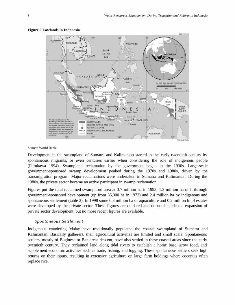
Figure 2 Lowlands in Indonesia
Source: World Bank.
Development in the swampland of Sumatra and Kalimantan started in the early twentieth century by spontaneous migrants, or even centuries earlier when considering the role of indigenous people (Furukawa 1994). Swampland reclamation by the government began in the 1930s. Large-scale government-sponsored swamp development peaked during the 1970s and 1980s, driven by the transmigration program. Major reclamations were undertaken in Sumatra and Kalimantan. During the 1980s, the private sector became an active participant in swamp reclamation.
Figures put the total reclaimed swampland area at 3.7 million ha in 1993, 1.3 million ha of it through government-sponsored development (up from 35,000 ha in 1972) and 2.4 million ha by indigenous and spontaneous settlement (table 2). In 1998 some 0.3 million ha of aquaculture and 0.2 million ha of estates were developed by the private sector. These figures are outdated and do not include the expansion of private sector development, but no more recent figures are available.
Spontaneous Settlement
Indigenous wandering Malay have traditionally populated the coastal swampland of Sumatra and Kalimantan. Basically gatherers, their agricultural activities are limited and small scale. Spontaneous settlers, mostly of Buginese or Banjarese descent, have also settled in these coastal areas since the early twentieth century. They reclaimed land along tidal rivers to establish a home base, grow food, and supplement economic activities such as trade, fishing, and logging. These spontaneous settlers seek high returns on their inputs, resulting in extensive agriculture on large farm holdings where coconuts often replace rice.

Toward an Integrated Perspective on Agricultural Drainage
9
Table 2 Distribution of lowland and government-sponsored development
Location
Land Sumatra Kalimantan Irian Jaya Sulawesi Total
Total swampland area Tidal Ha (’000) 6,604 8,127 4,217 1,149 20,097 % 20 24 13 3 60 Nontidal Ha (’000) 2,766 3,580 6,306 645 13,296 % 8 11 19 2 40 Total Ha (’000) 9,370 11,707 10,522 1,793, 33,393
% 28 36 31 5 100
Total area developed by Indonesian government
Tidal Ha (’000) 615 220 0 0 835 % 1.8 0.7 0 0 2.5 Nontidal Ha (’000) 279 192 6 2 480 % 0.8 0.5 0 0 1.3 Total Ha (’000) 895 412 6 2 1,315 % 2.6 1.2 0 0 3.8
Source: Ministry of Public Works, DGWRD 1996.
Most spontaneous settlers carefully select land on tidal riverbanks. These migrants are knowledgeable about basing their choice of land on the existing vegetation and other such indicators of suitability. Optimal use is made of the natural drainage outlets (tidal creeks) and the tidal range, which allows gravity drainage at low tide and tida l irrigation at high tide.
These settlers develop the land up to 2 km inland from the tidal rivers (figure 3). After establishing a clearing on the riverbank for settlement and rice cultivation, they gradually extend the drainage system inland. Over time, coconut plantings will take over from rice, especially where high tides cannot irrigate the land. Natural creeks are enlarged or narrow and deep canals are constructed perpendicular to the tidal river. The development continues inland until the drainage potential is exhausted. In a later stage, secondary canals perpendicular to, or in a fish-bone layout up to 1-km long, are excavated from the main canals or creeks.
Coconut trees are generally grown on mounds and drained by small field ditches. Rice is grown in fields shallowly flooded at high tide. Rice is usually a labor-intensive local variety, resistant to adverse conditions in the swampland, but with lower yields and a long growth period. The settlers construct only a few simple water control structures. Mostly the system is open, as the canals are used for boat transport and transport of coconuts to the river.

Water Resources Management During Transition and Reform in Indonesia
10
Spontaneous settlers form cohesive communities with strong ties to their areas of origin. Economic activities include agriculture, trade, fishing, and logging. These are seafaring, entrepreneurial people. The communities established often develop into villages and market places where intermingling with settlers of different origins may take place, but basically these communities are self-supporting.
Large areas have been developed this way. Increasingly, these settlements lose their isolation as other settlements crop up nearby. Few government programs have been designed and implemented to support these spontaneous and traditional settlements. The government bypassed these settlements in favor of the transmigration schemes.
Government-Sponsored Reclamation
Government-sponsored schemes are typically constructed in the swamp interior, farther from the tidal river than the spontaneous settlements. In official typology, government schemes are generally found in class B or C land, whereas spontaneous settlements have grow up in class A and B areas (box 2). Because of the distance to the main river, large primary canals connect these schemes to the rivers. Soil conditions are usually less favorable than they are in spontaneous settlements.
Under pressure of high transmigration targets, the program took various shortcuts in planning and design, which resulted in large-scale, overgeneralized, and rigid drainage designs. There were no reference points for swamp reclamation on this scale, and the capacity for adequate planning and supervision lagged behind implementation targets. The transmigration sites often caused considerable ecological damage, as they were developed close to deep peat forests, causing these to be drained as well. Some transmigration sites were developed close to nature reserves, and the infrastructure that came with them opened inroads into these areas.
Transmigrants came from the densely populated islands of Java, Madura, and Bali, where the farming culture is much different. On arrival, the farmers were assigned a plot of land, usually 2.25 ha, and had no choice in selection. Neither was any consideration given to the farmers’ origins, and hence the social fabric in government schemes was more heterogeneous than in the spontaneous settlements.
Despite the abundance of water in the tidal land, most government-sponsored swamp schemes depend on rainfall for water. Originally, the schemes were designed to provide minimal drainage, just the evacuation of excess rainfall, to support wetland rice cultivation. Schemes were generally designed with wide drain spacing and dead-ended canals.
Figure 3 A typical spontaneous lowland system
Source: Sriwijaya University Research Center, 2001; unpublished.

Toward an Integrated Perspective on Agricultural Drainage
11
Over the years, it became clear that this approach was too general. Views on minimal drainage changed in favor of controlled drainage for soil ripening and flushing and leaching of the toxicants and acids that cannot be prevented from forming during the long dry spells. That is why dead-ended canals have to be avoided, and larger canal cross-sections and a dense tertiary and on-farm drainage system constructed instead.
Minimal drainage resulted in stagnant water conditions and crops affected by acidity and toxicities due to poor leaching and flushing. Water retention and poor drainage also hampered soil ripening and therefore the introduction of mechanization. The proper design criteria for drainage are still being discussed, and many of the recommendations stem from empirical observations. A more elaborate description of lowland reclamation is given in appendix B.
The reclamation of tidal swampland involves drainage of unconsolidated, often acid-sulphate, clays (PASS) and organic soils, to ripen soil. During this period, the land is marginally suitable for agricultural production and has a low productivity. Drainage is also required to flush acidities and toxicities related to the oxidation of acid-sulphate and decomposition of organic soils. A third objective of drainage is the control of water levels and evacuation of excess rainfall for different crop requirements (e.g., rice, dryland crops, or tree crops).
Until soils mature, drainage design and operation is a balance between these conflicting objectives. The complexity of drainage operations is intensified by the micro-diversity of soil conditions and topography, the tidal regime and tidal range, the changing physical conditions over time, and conflicting crop needs.
An essentially different water management situation exists for land that can be tidally irrigated (classes A and B). Here, sufficient water is available for leaching and flushing, and the soil and water quality is better and suitable for wetland rice cultivation. While many of the spontaneous settlements are located in tidal irrigated lands, only a minor part of the government-sponsored schemes have access to tidal irrigation.

Water Resources Management During Transition and Reform in Indonesia
12
Box 2 Detailed typology of lowland swamp development
In Indonesia’s tidal land, four water management categories are commonly distinguished, based on the tidal irrigation potential in-situ, the hydrotopography. This function is determined by the relation between the tidal range in the river, the dampening of the tides in the drainage system, and the topography. The four hydrotopographical categories in tidal swamp schemes are: § Class A. Tidal irrigated areas where the fields can be flooded at least four to five times at high tide during a 14-
day spring tide cycle in both wet and dry cropping seasons, and where tidal supply provides sufficient leaching for proper soil and water quality
§ Class B. Tidal irrigated areas where the fields can be flooded at high tide at least four to five times at high tide during a spring tide cycle only during the wet cropping season and where less water is available to maintain soil and water quality
§ Class C. Areas just above tidal high water, where the fields cannot be flooded at high tide but where the tides still influence groundwater levels, and where leaching of the root zone from acids and toxicants depends entirely on rainfall and percolation through controlled drainage
§ Class D. Higher areas where the fields are not subject to tidal influence [lebak ].
A further distinction with regard to agricultural suitability is usually made in soil type (e.g. mineral versus organic soils), the presence and depth of acid-sulphate layers, the thickness and type of peat layers, soil fertility, and ash content. Other factors include potential and future drainability, salinity intrusion, and flooding.
As a consequence of reclamation, the physical characteristics change considerably over time. The micro-diversity of physical characteristics also appears to be a major factor in land and water management–especially access to drainage and supply and soil and water quality control. This was initially overlooked in the rigid designs, focused on minimal drainage and wetland rice cultivation. Most transmigration sites are located in the hydrotopographical categories B and C.
In nontidal areas, a differentiation in flooding regime is common, based on depth and duration of back swamp flooding. The main crop is usually rice. Reclamation of these areas requires precise knowledge of the river regime and flooding characteristics and the relation to topography and soils.
The classification of nontidal swamp areas consists of:
§ Class I. Shallow inundations over short periods § Class II. Medium-deep inundations over longer periods § Class III . Deep inundations over longer periods or permanently.
Drainage is facilitated through different kinds of canals within the schemes, connected to the tidal rivers through primary and navigation canals, allowing for gravity drainage at low tide, with or without the aid of water control structures, as well as intrusion at high tide, allowing for flushing, leaching, and tidal supply. The drainage infrastructure serves the additional purpose of navigation, control of salinity intrusion, and flood protection.
Rehabilitation and upgrading of the limited drainage systems in previously developed lowland sites in the 1980s, together with agricultural support services, raised productivity. However, the interventions fell short of the integrated approach required to address a range of issues in the lowland systems. Integrated interventions in the 1990s were more successful—including the development of controlled drainage, the development of local organizations, and resolution of issues such as land titling and safe drinking water supplies. Useful lessons were learned during the integrated swamp development program.
It is therefore surprising that, in 1995, the New Order regime embarked on swamp development project in Central Kalimantan, repeating the mistakes of the past on an even larger scale (box 3). The One Million Hectare project sought to develop a huge lowland area for rice cultivation and dry crops. Yet the design
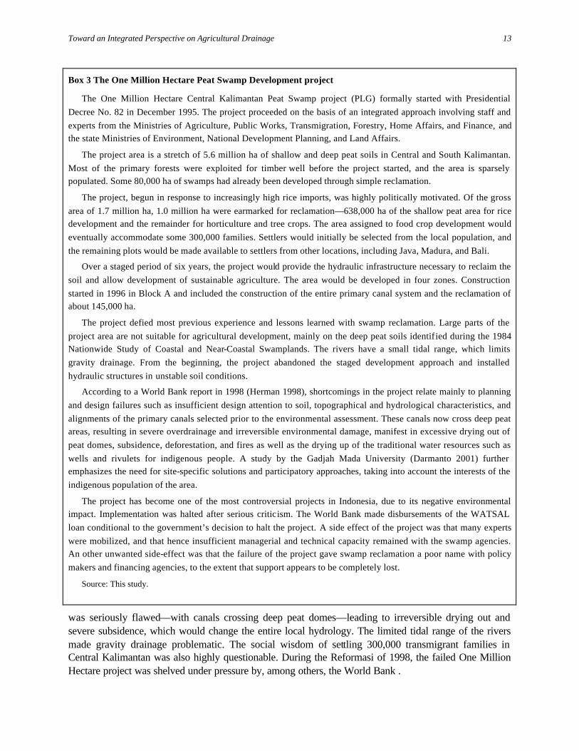
Toward an Integrated Perspective on Agricultural Drainage
13
Box 3 The One Million Hectare Peat Swamp Development project
The One Million Hectare Central Kalimantan Peat Swamp project (PLG) formally started with Presidential Decree No. 82 in December 1995. The project proceeded on the basis of an integrated approach involving staff and experts from the Ministries of Agriculture, Public Works, Transmigration, Forestry, Home Affairs, and Finance, and the state Ministries of Environment, National Development Planning, and Land Affairs.
The project area is a stretch of 5.6 million ha of shallow and deep peat soils in Central and South Kalimantan. Most of the primary forests were exploited for timber well before the project started, and the area is sparsely populated. Some 80,000 ha of swamps had already been developed through simple reclamation.
The project, begun in response to increasingly high rice imports, was highly politically motivated. Of the gross area of 1.7 million ha, 1.0 million ha were earmarked for reclamation—638,000 ha of the shallow peat area for rice development and the remainder for horticulture and tree crops. The area assigned to food crop development would eventually accommodate some 300,000 families. Settlers would initially be selected from the local population, and the remaining plots would be made available to settlers from other locations, including Java, Madura, and Bali.
Over a staged period of six years, the project would provide the hydraulic infrastructure necessary to reclaim the soil and allow development of sustainable agriculture. The area would be developed in four zones. Construction started in 1996 in Block A and included the construction of the entire primary canal system and the reclamation of about 145,000 ha.
The project defied most previous experience and lessons learned with swamp reclamation. Large parts of the project area are not suitable for agricultural development, mainly on the deep peat soils identified during the 1984 Nationwide Study of Coastal and Near-Coastal Swamplands. The rivers have a small tidal range, which limits gravity drainage. From the beginning, the project abandoned the staged development approach and installed hydraulic structures in unstable soil conditions.
According to a World Bank report in 1998 (Herman 1998), shortcomings in the project relate mainly to planning and design failures such as insufficient design attention to soil, topographical and hydrological characteristics, and alignments of the primary canals selected prior to the environmental assessment. These canals now cross deep peat areas, resulting in severe overdrainage and irreversible environmental damage, manifest in excessive drying out of peat domes, subsidence, deforestation, and fires as well as the drying up of the traditional water resources such as wells and rivulets for indigenous people. A study by the Gadjah Mada University (Darmanto 2001) further emphasizes the need for site-specific solutions and participatory approaches, taking into account the interests of the indigenous population of the area.
The project has become one of the most controversial projects in Indonesia, due to its negative environmental impact. Implementation was halted after serious criticism. The World Bank made disbursements of the WATSAL loan conditional to the government’s decision to halt the project. A side effect of the project was that many experts were mobilized, and that hence insufficient managerial and technical capacity remained with the swamp agencies. An other unwanted side-effect was that the failure of the project gave swamp reclamation a poor name with policy makers and financing agencies, to the extent that support appears to be completely lost.
Source: This study.
was seriously flawed—with canals crossing deep peat domes—leading to irreversible drying out and severe subsidence, which would change the entire local hydrology. The limited tidal range of the rivers made gravity drainage problematic. The social wisdom of settling 300,000 transmigrant families in Central Kalimantan was also highly questionable. During the Reformasi of 1998, the failed One Million Hectare project was shelved under pressure by, among others, the World Bank .

Water Resources Management During Transition and Reform in Indonesia
14
Private Sector Investment
Private investors are the most recent agents involved in lowland reclamation. The private sector is basically interested in aquaculture, for example, fisheries and shrimp farms, and agricultural estates based on monoculture tree crops such as oil palm, coconut, and pineapple. Many of these estates are supported by a transmigration-driven smallholder component, which provides labor to operate the estates. The One Million Hectare project also had a large component that was to be developed by private capital.
The uncontrolled development of the lowlands in the last few years reflects the lack of any overview of the extent and location of private sector reclamation of lowlands. This is particularly worrisome, because it makes difficult land management and the creation of buffer zones around sensitive areas (nature reserves or deep peat areas). Even in the past, private estates were logging operations in disguise—opening an area but moving out once it was cleared of trees. The risk is large that this practice will continue—with even fewer checks and balances.
Framework Needed for Future Lowland Management
During a review of the national swamp development program conducted in 1998 and updated in 2000, (Ministry of Public Works, DGWRD 1998), a case was made for improved planning and management of the lowlands in Indonesia, to avoid the mistakes of the past, based on updated inventories and assessments of lowland resources (see figure 4 at the end of this section). The same point was put on the agenda of the National Water Resources Policy as a component of the reforms.
A national lowland management plan would link up lowland development with the current national development goals, water sector reforms, and the move to river basin planning. Lowland development is now marked by laissez-faire and has become water policy’s blind spot. This is in spite of the environmental impact of both planned and uncontrolled lowland use and the contribution that lowland areas make—and can make—to food security. Improved planning and management of lowlands should support decentralization policies—to equip local governments in this field. It should help in finding a better balance between development and environmental priorities and identifying quick-yielding interventions in existing swamp schemes.
Balancing Environment and Development in Lowland Management
The reclamation of swamps and the opening up of new schemes have had major environmental impacts on the forests, wetlands, wildlife, and local communities. So much clearing of primary forests took place that very little remains in or near the schemes and what does remain is largely degraded forest. There is also considerable pressure from the schemes on surrounding forests. Appendix C gives a comprehensive overview of environmental risks and impacts of swamp reclamation. They concern loss of vegetation cover and related biodiversity and habitats. They also concern changes in soil conditions that will affect land suitability and water quality, particularly where site selection was ill-advised or water management is deficient. The leachates from acid sulphate soils and toxic iron releases from the reclaimed areas may affect—though temporarily—local fisheries, although by far most of the acidity and toxicity is caused by natural releases. There are also impacts from the reclamation areas on the surrounding environment—the risk of overdrainage of adjacent deep peat areas, pressure of new and inexperienced settlers on the surrounding forest, and the effect of new road infrastructure in providing access to protected areas.

Figure 4 Staged swamp development
GOVERNMENT POLICIES GOVERNMENT POLICIES GOVERNMENT POLICIES- Rice self-sufficiency - Poverty alleviation - Assumed to be identical to these
during second stage- Transmigration - Regional development- Development of outer islands - Export commodities- Income distribution - Private sector involvement- Security of coastal borders - Improvement of income and welfare
- Food self-sufficiency- Environmental sustainability- Decentralization
PROJECT GOALS and OBJECTIVES PROJECT GOALS and OBJECTIVES PROJECT GOALS and OBJECTIVES- Reclamation of new swamp areas - Integrated approach - Integrated approach- Low technology infrastructure (low cost) - Rehabilitation and upgrading - Full resources development- Subsistence farming, rainfed rice and palawija - Efficient operation and maintenance (O&M)with cost recovery - Completion of decentralization process- Smallholder schemes - Institutional strengthening - No below-poverty farmers
- Intensification and diversification of agriculture - Sustainable agriculture- Improved agricultural support and social services- Farm mechanization- Improved resource use- Coastal zone management
SOCIOECONOMIC INFRASTRUCTURE SOCIOECONOMIC INFRASTRUCTURE SOCIOECONOMIC INFRASTRUCTURE- Basic health care and other social services - Improved health care and other social services - Functional cooperations / credit facilities- Accessibility and communication based on water transport - Access roads and internal farm road systems - Adequate social facilities- Basic roof catchment drinking water - Improved drinking water facilities - Rural electrification- Basic agricultural support services - Improved agricultural support services - Agro-industries
- Improved access to marketing and agroprocessing facilities - Integrated in regional road network
HYDRAULIC INFRASTRUCTURE HYDRAULIC INFRASTRUCTURE HYDRAULIC INFRASTRUCTURE- Open drainage system and flood protection - Semi-controlled drainage system - Fully controlled water management- Tidal irrigation where possible - Improved soil-water management - Irrigation- Water conservation elsewhere - Empoldering
KK 4.0 M Indicative Agricultural Income per Family
Full resources developmentKK 2.0 M Constraints : Soil -water management
KK 1.6 M (poverty line) Neglected O&M
Poor accessibility
Poor services Integrated swamp developmentKK 0.5 M
Rehabilitation/special maintenance
F I R S T S T A G E S E C O N D S T A G E T H I R D S T A G E
Source: Ministry of Public Works, DGWRD, 1998.

Water Resources Management During Transition and Reform in Indonesia
16
In lowland reclamation, there are no simple win-win situations, but negative environmental impacts can be considerably mitigated by several measures. This scope for mitigation provides a strong argument against leaving lowland development and management the “free for all” it is now (table 3). The most important one is at policy level—to give preference to second-stage development in existing areas instead of reclaiming new areas. The reason for this preference is straightforward: in the reclaimed areas, the ecological damage has already been done. In areas with considerable sunk environmental costs, it is better to improve livelihood conditions and agricultural productivity. Moreover, gains in agricultural productivity in second-stage swamp development appear to be as high if not higher than in the initial opening up of new areas. In Indonesia’s current decentralized constellation, large-scale reclamation programs as they occurred in the past are also less feasible politically. In already reclaimed areas, the parts suitable for second-stage development should be identified. For remaining lowland forests, conservation and rehabilitation areas as well as areas suitable for new agricultural development need to be designated and discussed with local governments. Instead of ignoring the problem, a framework for lowland management is required—one that would reconcile the priorities of different interests and sectors such as agriculture and farming.
Next, improved land management planning and site selection around the reclaimed sites would also limit damage. Areas with peat layers more than 1 m deep or shallow layers of potential acid-sulphate soils should be avoided. Improved land use planning would mean that land reclamation and new road and transport development should be kept a safe distance from protected forests and from areas with deep peat domes. Experience from the Integrated Swamp Development project also suggests that wide roads invite illegal logging, and hence should be avoided where possible. Silvius and Giesen (1996) argue that land management plans should be actively enforced. This would consist of clearly demarcating national parks, production forests, and conversion forests. Ideally, production forests should surround national parks and act as a buffer to encroachment. Silvius and van Giesen suggest that, in the management of production forests, local groups should be given the right to maintain and exploit the forest—along the lines of the joint forestry (India) or “camp fire” (Southern Africa) programs.
Table 3 Measures to mitigate environmental impact of lowland reclamation
Impact Mitigating measures
Policy level Opening up of pristine areas—loss of biodiversity, destruction of adjacent forest and deep peat areas, loss of buffering capacity
Concentrate second-stage development in areas already developed—either earlier reclamation projects or spontaneously developed areas. Give low priority to new reclamation. Establish resource inventories. Allocate land by intended use—development, conservation, rehabilitation Enforce the laws.
System level Irreversible hydrophysical development of peat soils
Select development areas carefully so as to avoid peat layers at more than 1 m depth.
Negative impact on water quality, because of acidification of potential acid-sulphate soils
Avoid areas with shallow potential acid-sulphate soils. Provide for adequately operated water control systems —retention and regular flushing.
Collateral effects to neighboring nature reserves and deep peat areas
Do not convert forest bordering protected areas—buffer zones of production forests. Do not develop drainage development in vicinity of deep peat soils. Plan roads carefully.

Toward an Integrated Perspective on Agricultural Drainage
17
A third category of mitigating measure concerns improved local water management. Water storage and well-timed flushing can reduce acidification considerably. To a large extent, changes in soil composition are unavoidable and are, in fact, part of the reclamation. The process of soil ripening can, however, be accelerated by adequate local water control.
Staged Lowland Development
The preference for second-stage development suggests that public responsibility for lowland development should not end at the first stage of land reclamation. Staged development is the guiding principle for swampland reclamation—accepted by the Indonesian government but not formalized as a policy. Full development or full utilization of resources can be achieved only through a series of interventions over time because of the long maturation process of the unconsolidated potential acid sulphate clays and peat soils.
Much has been learned over the last decades concerning first and second-stage development, although there is no final protocol. Unlike in other counties, there is no knowledge center in Indonesia for swamp development, and much of the knowledge is scattered over government departments, research institutes, and consulting agencies. The timeframe for lowland development is not rigid. Developments will not advance simultaneously, and requirements for inputs will vary and change by location. Staged lowland development in other words, though an ongoing process, can be broken down into stages (figure 4).
First-Stage Development. First-stage swamp development was directed at smallholder rainfed wetland rice cultivation. Interventions were based on low-cost, simple technology with minimal infrastructure requirements. Characteristic of this phase are an uncontrolled drainage system, minimal flood protection, partial land clearing, construction of simple housing and drinking water facilities, earth roads, and bridges and the provision of basic support services in agricultural extension, education, and health care. As the emphasis is on soil ripening, during which a considerable change of land levels and load-bearing capacity takes place, putting the final infrastructure in place is not effective.
In government-sponsored schemes, farmers were allotted 2.25 ha of land, but, as no mechanization is possible, usually these parcels are only partially cultivated. Cropping patterns consist of a single wet season rice crop, mixed with dryland and tree crops, generally keeping farm incomes below or just at subsistence level.
These inherent limitations on swamp development have been aggravated by the often ineffective and unrealistic implementation of the transmigration program and the considerable technical and institutional shortfalls accompanying it. The assessment of natural resources was insufficiently detailed, resulting in the development of less suitable areas and suboptimal design of the drainage infrastructure. Moreover, the complex processes of physical and chemical soil ripening under various conditions were insufficiently understood. The result was slower-than-anticipated development. Still, rice productivity increased from 0.5 to 1.5 t/ha in the early years.
Other shortcomings that contributed to stagnating development, and which were insufficiently recognized and addressed in the program design, include socioeconomic factors such as lack of community cohesion, physical isolation, poor drinking water, communication difficulties, and poor access to education, health facilities, and agricultural and marketing services.

Water Resources Management During Transition and Reform in Indonesia
18
S e c o n d- S t a g e D e v e l o p m e n t
Not every part of a reclamation scheme would necessarily qualify for the next stage of development. Some parts should be considered unsuitable, and resettlement may be the best option; other parts might better be put to different land uses. Many areas do, however, qualify for further interventions and investment.
As the soil ripening process continues, physical conditions change drastically in 10 to 15 years. Development and agricultural production stagnates unless further investments are made. Development has reached a phase where drainage should be extended and water control introduced. Second-stage development requires a wide range of technical and institutional interventions. At this stage, additional inputs and infrastructure are introduced to revitalize the settlements to a level where settlers can improve their standard of living beyond subsistence level. In principle, the 2.25-ha land holdings are to be fully cultivated and cropping patterns, including diversification, attuned to the actual potential of the land. The soils are sufficiently ripe to allow mechanization.
Experience with second-stage development is available through two projects, the Asian Development Bank–financed Telang-Saleh Agricultural Development project in South Sumatra under Irrigation Subsector project (ISSP), also ADB financed (1993–97), and the World Bank–financed Integrated Swamp Development project in Riau, Jambi, and West Kalimantan (1995–2000). The two projects cover some 140,000 ha, about 10 percent of the total government-sponsored lowland development program.
Both projects contained large system rehabilitation and upgrading components but were especially successful in testing integrated O&M model areas, where technical interventions were coupled with on-farm strengthening, community building, and active participation of water user associations, nongovernmental organizations (NGOs), and community organizers. In these trial areas, the best results were achieved, but efforts went on for only a short period, leaving questions about their sustainability. They did, however, at least show that the methodologies were suitable for application on a broader scale.
Table 4 Rice yields in monitoring units in Telang and Saleh (t DUR/ha)
Telang Sub units and hydro-topographical classification SMU P3 3S P5 2N P6 3N All TMU A B C A B C A B C A B C All 1993/94 2.5 2.3 2.9 2.3 1.6 2.9 2.3 1.9 2.9 2.3 1.9 2.3 1994/95 2.5 2.8 2.5 1.6 1.8 2.8 2.3 1.0 2.7 2.1 1.9 2.2 1995/96 2.2 2.4 2.5 2.0 2.5 2.3 2.4 2.7 2.4 2.2 2.5 2.4 1996/97 2.2 3.1 2.5 2.0 2.3 4.3 2.8 2.2 3.4 2.3 2.6 2.7 Average 2.4 2.6 2.6 2.0 2.1 3.1 2.4 2.0 2.8 2.3 2.2 2.3
Saleh Sub units and hydro-topographical classification SMU P8 3N P8 3S P10 2S All TMU A B C A B C A B C A B C All 1993/94 4.5 3.3 3.5 3.1 3.8 4.6 3.7 3.2 1.5 3.8 3.4 3.2 3.3 1994/95 6.4 4.6 4.5 4.4 4.7 5.2 3.9 4.4 3.9 4.9 4.6 4.5 4.5 1995/96 3.6 3.2 2.4 2.6 3.2 3.7 2.6 3.4 2.7 2.9 3.2 2.9 3.0 1996/97 4.5 4.1 3.3 3.2 3.5 5.3 3.1 3.0 3.0 3.6 3.5 3.9 3.6 Average 4.8 3.8 3.4 3.3 3.8 4.7 3.3 3.5 2.8 3.8 3.7 3.6 3.7
DUR Dry unmilled rice; SMU secondary monitoring unit; TMU tertiary monitoring unit. Source: Ministry of Public Works, DGWRD. 1998.

Toward an Integrated Perspective on Agricultural Drainage
19
Table 4, based on monitoring in the two projects, indicates the scope for improvement in terms of rice yields, increasing to between 2.5 and 3.5 t/ha. Saleh was included in the ISSP-1 program in 1988–91. At the time, rice yields averaged between 0.5 and 1.5 t/ha. The scheme is typical of the higher topographical classes, hydrotopography C and D (box 2). The scheme was again included under the Telang-Saleh project (1993–97), where integrated monitoring units were established. Yields at the start of the project had already improved considerably since the earlier drainage improvements under ISSP-1 (table 4).
Telang was for the first time included in a rehabilitation program. The area is representative of the lower and more suitable topographical categories, hydrotopography A and B. The table shows improvement during the project, but the real impact will occur after improved drainage raises soil and water quality. During the field visit as part of this study, it was reported that yields had increased to between 4.0 and 6.0 t/ha.
Both second-stage development projects showed that even the focused approach of the projects failed to address micro-level but critical issues at field level. This would take more time and broader farmer participation in planning, design, and O&M. It would also require a different project design, one allowing greater flexibility in construction planning and a field-to-field approach.
The main lessons from second-stage development are (World Bank 2001b):
• Swamp development requires an integrated approach that includes water management, food and tree crops production, and provision of essential services such as roads and water supply. Such an integrated approach requires good institutional capacity and adequate time to ensure effective coordination among implementing agencies.
• Decentralized project design and planning, involving active participation of local government and other stakeholders, is essential for defining real needs and setting priorities among them, thus improving the chances of project success. Strengthening the planning capacity at provincial level and lower levels is an important but long-term process that requires sustained support.
• Swamp development is a long-term process and requires more than the typical five-to-six- year project timeframe. Such projects should be implemented in phases over a much longer period to accommodate community development in a difficult environment and to allow an appropriate sequencing of water management improvement and development activities.
Third Stage Development. A third stage of development would encompass full management of the resources and the achievement of maximum productivity. This stage would also assume the final interventions required by the government. Polder development, irrigation, subsurface irrigation, and full mechanization are some of the possible components of this stage.
Contribution of Lowland Development to Food Security
Accurate statistics on lowland cultivation or yields are hard to come by, and there are many complete blanks, for instance, on the area under spontaneous reclamation. Best estimates put the contribution of government-sponsored tidal swamps at 3.5 percent of national rice production (Ministry of Public Works, DGWRD 1998) Adding in the spontaneous settlements will increase this figure. The contribution of lowlands is hence not marginal. Moreover, in terms of food security, the swamp areas are less affected by droughts than other parts of Indonesia.
The tidal swamps take care of approximately 11 percent of the entire rice growing area, outside Java. Yields in South Sumatra are on a similar order of magnitude as upland yields in the same area (figure 5).

Water Resources Management During Transition and Reform in Indonesia
20
More detailed data, though piecemeal, suggest that, with improved drainage, yields in existing lowland systems can expand by 2.0 to 2.6 t/ha in Telang I and 1.7 to 3.5 t/ha in Saleh (table 4). The area under cultivation also increased—from 82 percent to 100 percent in the wet season in some areas. These figures were recorded soon after second-stage rehabilitation, and anecdotal evidence suggests that yields have further increased since then.
Hence significant gains can be made by improving lowland systems. Overall investments in first stage of swamp drainage infrastructure development have been on the order of US$1,000 to US$1,500/ha. Including settlement costs, an average of more than US$5,000/ha was invested in the ex-transmigration schemes.
Second-stage development requires additional investments on the order of US$1,000 to US$1,500/ha for food crop development or US$2,000 to US$2,500/ha for tree crops. Investments up to second-stage swamp development are generally well below the level of investments made in gravity irrigation systems, while agricultural production potentials in swamp schemes are not far below those in irrigation schemes.
Figure 5 Rice areas on the outer islands
Rice Area Outside Java (5,121,880 ha)
Other22%
Rainfed26%
Tidal swamps
11%
Technical irrigation
11%Semi-
technical irrigation
10%
Village irrigation
20%
Source: Ministry of Public Works, DGWRD, 1998.
3. Institutional Development in Drainage and Water Resources Management
See-saw changes have beset the institutions involved in drainage management over the last 40 years. The expansion of the lowland development program was associated with the establishment of a strongly centralized Directorate of Swamps within the Ministry of Public Works. The directorate ceased to exist, and its activities were merged with the Directorate of Irrigation in the mid-1990s. After the political changes of 1997, the Ministry of Public Works, too, was done away with—an unprecedented move in

Toward an Integrated Perspective on Agricultural Drainage
21
many ways, as elsewhere in the world similarly powerful organizations have created their own conditions for survival. The background was the decentralization of the Indonesian government, which left the districts in charge of water resources development and management.
At farmer level, several organizations exist. In the spontaneously developed lowland systems, informal arrangements take care of basic water management functions and also serve to organize joint agricultural labor. In government-sponsored systems, some attempts at introducing water user associations have been made—some successful, some not.
Recent water sector reforms in Indonesia have the potential to decisively influence drainage management. Central planks are improved regulation, management transfer, and river basin management. So far, however, these reforms have not addressed the lowland development program.
The Development Decades: 1960s –1980s
According to the 1945 Constitution, water is a gift of the Almighty God and as such must be used for the welfare of the people. By law, the administration of all water resources, including the natural riches contained therein, was made a public responsibility.
Box 4 Managing local lowland systems
A parit is a traditional main canal that conveys water from the land to the river and vice versa. A parit can be a small natural creek or a manmade canal. Typically constructed by a group of 15 to 20 local people, chaired by one kepala parit [head of parit). In a large system, there are several parit units 1,000 m long and 500 m from the nearest parit. There will be separate head for the combined parit gabungan. The land surrounding the parit is normally tidal with alluvial soils deposited by the nearby river. There are usually no gates or water control system for the parit. The rice yield is about 2.5 t/ha of the local long-maturing variety. Land clearing starts with slashing of the grass and shrubs in February and letting it decompose with flooding. Rice is planted in March or April. Some farmers apply fertilizer. There are no droughts in the parit areas, as the soil always has sufficient water. Land holdings range from 0.5 to 1.5 ha. Every farmer contributes equally to common works, irrespective of the size of his landholding. Besides rice, coconut is another source of income. Fishing supplements diets.
The heads of a single parit, a parit gabungan elected by the group members, organize the unit’s operation and maintenance. Three times a year group members work jointly: during the preparation of the land and seedbeds, during the vegetative growth of rice, and during the harvest. Each group member works once a week about four hours, starting around 9 A.M. and continues working a day a week until the work is finished. For example, if a parit is 1,000 m long and 20 people can cover 200 m a day, the group has to work together for five days to do the job.
Source: Sriwijaya University Research Center, 2001; unpublished.
In the meantime much of the water resources development in Indonesia was, has been, and is a private or community affair (box 4)—at times triggered by local leaders or religious institutions. The spontaneous swamp development by seafaring groups such as the Buginese and Banjarese—stretching over decades—is a prime example (section 2). There are many more examples—where local land and water resources were used to develop irrigation supplies, field drainage, and flood protection. In Central Java, for instance, even after several “development decades,” nearly 45 percent of the irrigated area is served by village or sederhana [simple] systems, most of them with a history of local management.

Water Resources Management During Transition and Reform in Indonesia
22
For a long time, Dutch colonial-era regulations dating to 1936 guided the management of water resources. After 1969, additional laws and regulations were formulated, directly or indirectly related to water resources development.
Box 5 Handing over—deadly ambiguity
Formal transfer of government-sponsored lowland systems has been problematic, and few, if any, schemes were officially transferred to the provincial governments upon completion. Under the Irrigation Subsector project, the systems were transferred to temporary provincial organizations (P2JP) and later integrated in the provincial water resources services. The problem is that in every instance the handing over is “assumed” to have taken place, but without matching budgets. The provinces, in turn, consider districts responsible. It all ends up in deadly ambiguity, where maintenance funds are short in coming, and parties at the receiving end make up their own priorities.
Source: This study.
In the pre-1969 period, water resources development was concentrated on irrigation, river improvement, urban drainage, and agriculture through expansion of the irrigation and drainage infrastructure, housing and settlement, water quality, management of rivers, flood control, and drought prevention. During this time, transmigration started to operate on a large scale.
Indonesia’s state budget, which was largely dependent on revenues from resource extraction, ballooned after the meteoric rise of oil prices in the early 1970s. For a time, money was chasing useful pursuits. A powerful Department of Public Works came into being—strongly centralized, as was the mode of government in the Orde Baru period. Within the Ministry of Public Works, there used to be a clear distinction between irrigation and swamp development. The Directorate of Swamps managed the substantial lowland development portfolio and its financing as part of the transmigration program. Nearly 1.3 million ha of swampland was “developed,” although much of it was inadequately designed or left incomplete (Herman 2002). The directorate was responsible for all activities—planning, design, and construction of swamp schemes. It was also responsible for O&M during the initial years after construction until hand over to the provincial government, if that happened (box 5). In the pattern set by the directorate, engineering was done by the central level, with assistance of projects in the provinces under responsibility of the central agency, and with little or no coordination with regional government or water users. All knowledge and know-how was bundled into a single agency. The drawback was that few skills were developed outside it—either in the private sector or elsewhere in government. The strongly centralist approach meant that the government-sponsored lowland development program suffered casualties due to inappropriate blueprint designs, insufficient field surveys, or inadequate feedback from field to center. The low point in this development was the One Million Hectare Peat Swamp Development project of the mid-1990s.
Shift to Systems Management: 1980s and 1990s
In 1987, the first systematic effort was made to shift the emphasis from development to management of water resources systems—particularly in the irrigation sector, but also in river basin management. The downswing in the oil market and its impact on Indonesia’s revenue was one explanation for the policy shift. Indonesia turned into an important borrower from multilateral banks and bilateral agencies (particularly Japan). Participatory management developed into an international paradigm in irrigation

Toward an Integrated Perspective on Agricultural Drainage
23
management (drainage was absent from the discussion), although examples of “good practices” were at that time limited to the Philippines’ experience.
The Irrigation Operation and Maintenance Policy (IOMP) formulated in 1987 consisted of a number of elements to improve management of irrigation infrastructure—handing over small irrigation systems (less than 500 ha), the introduction of irrigation service fees in larger systems, and the introduction of need-based budgets.
In the small irrigation systems turn-over component of IOMP, water user associations were to be established—taking over O&M responsibilities after system rehabilitation (called “corrective maintenance”). In larger systems (above 500 ha) service fees were to be introduced and, again, water user associations were set up—at tertiary level. The methodology of the service fees program was for O&M requirements to be jointly identified through system walkthroughs and discussion in consultative bodies, consisting of selected heads of federations of water user associations. A contract was made—verified by the district administration as the regulatory third party—for the Public Works Department to provide these services. The third plank in the Irrigation Operation and Maintenance Policy was needs-based maintenance budgeting. Instead of relying on standard per hectare allocations, maintenance funding was to be based on “actuals,” costs observed in the field. Loans were made available to support O&M budgets for a transitional period.
Although most of these policy innovations focused on changing the management of irrigation systems, a number of efforts were also extended to the lowland systems. Separate O&M standards were developed for the swamp scheme to fit the different conditions there.3 Water user associations were developed at tertiary units, but in drainage schemes lacked a clear agenda. Creating user organizations in the relatively new transmigration settlements was more difficult because of the heterogeneity of the settler groups and the large turnover among the settler population in the early years. Water management in the government-sponsored tidal lowland systems, moreover, is more complicated than it is in the spontaneously developed settlements, where farmers usually have access to tidal irrigation (section 2), allowing flushing and accelerating soil development.
Despite good ideas and intentions, little of the Irrigation Operation and Maintenance Policy survived the test of time. There are number of analyses as to what undid the different efforts. One explanation is that, besides the institutional revamping of the systems, there was considerable budget for rehabilitation. This was provided under the guise of “corrective maintenance” but meant that, in the end, all the attention was diverted to construction and reconstruction, and institutional development was neglected (Bruns 1999). Water user associations faded away or, in small systems, earlier informal institutional arrangements took over again. A second analysis of why little remained puts the blame on the water user associations’ lack of legal standing and the lack of value-added things for them to do. In the swamp areas, for instance, WUAs were expected to take care of open systems and, after upgrading, secondary water management control structures. Inadequate main system management, however, often impaired their functioning. There were also large differences among farmers in a tertiary and secondary block—in terms of land quality, proximity to the primary canal, and extent of lowland development (figure 6). Much of what had been created as WUAs in irrigation and drainage systems disappeared. The different elements were heavily tilted toward the formalities of water user associations, an organizational approach to
3 When the Directorate of Swamps was merged with the Directorate of Irrigation, these procedures were abolished to suit the standards for irrigation management.

Water Resources Management During Transition and Reform in Indonesia
24
management, rather than toward a management approach to water problems. The story resembles that of the WUAs in Pakistan’s On-Farm Water Management project, India’s Command Area Development, or Egypt’s collector-user associations. The Irrigation Service Fee Program of the IOMP also ran into a dead-end. Outside the large pilot areas, interest was lukewarm, and fees were not administered separately and became indistinguishable in the district budget. The district consultative bodies, the walkthroughs, and negotiations after a while were considered too time consuming. Moreover, after a series of budget cuts, the government was unable to deliver. Demand-driven and local management elements were introduced in a context and superstructure that revolved around the core business of construction and was not good at operation.
Figure 6 Micro-variation in Telang unit—complicating local management
Flood map – Tidal Irrigation Class Wet Season
Drainage Map – Potential Drainage Depth Wet Season
Source: Euroconsult 1997.
No comparable parallel effort had been made under IOMP to reengineer the institutional arrangements in drainage and strengthen lowland management, despite the large area under lowland drainage at that time. Only later—starting in 1993—were models for participatory O&M tested in drainage in the Second-Stage Swamp Development projects [Telang Saleh] and the Integrated Swamp Development project. WUAs were contracted to implement simple routine maintenance of the main system. The introduction of drainage service fees was considered but subsequently cancelled, as many farmers were living at or below subsistence, willingness to pay was not great, and construction was incomplete. In swampland reclamation, it takes several years, while drainage improves soil and water quality, until the impact of technical interventions shows up as increased agricultural productivity. Alternatives to drainage service fees seemed more viable such as farmers’ taking over routine maintenance of parts of the hydraulic infrastructure (box 6).

Toward an Integrated Perspective on Agricultural Drainage
25
Box 6 Telang 1 water user association
Under the Telang and Saleh Agricultural Development Project, 1993–96, incomplete water management infrastructures were rehabilitated, water user associations were established, and empowerment and intensive agricultural extension took place in several areas of the Telang I system (Banyuasin District, South Sumatra). These second-stage interventions improved farmers’ livelihoods and created job opportunities. Although there is no road from the neighboring areas, there are more then 30 cars in Telang I now (none in 1996). The cars, owned by local farmers, are used to transport people, rice, materials, and other goods from one area to another in Telang I. Whereas there were only 4 hand tractors in 1996, now there are more then 200.
Each of the transmigrated farmers previously had 2 ha of first- and second-holding land for cultivation of food or annual crops. Additionally, 0.25 ha was allocated for a home plot. Some farmers who bought land from local village people or from neighbors who returned to Java now own 3 to 6 ha. Shortage of labor is common, and agricultural mechanization is required.
The farmers operate and maintain the hydraulic infrastructure at tertiary level during the planting season. The increase in farm income in the last 10 years has been spectacular.
Source: This study.
Except in a few places where WUAs take care of tertiary infrastructure, the Indonesian government has financed O&M in government-sponsored lowland systems either fully or partially, through loan support with complementary funds. There has been no user funding. Invariably the sustainability of these external financing mechanisms is dubious, and there has never been enough O&M funding. After the financial crisis of 1997, provincial governments received block grants for O&M. Irrigation schemes were given priority for block grants, and no budget reached the swamp reclamation schemes, where maintenance is critical for proper soil and water management.
Water Sector Reforms —Beyond 1998
With the economic and political crisis of the late 1990s, attention for lowland drainage suddenly disappeared. In 1994, the Directorate of Swamp Development was abolished, its activities mainstreamed into the general operations of the Public Works Department. The directorate’s responsibilities were absorbed within the organization for irrigation development, and guidance to swamp development was delegated to subdirectorate level. With this development, specific expertise in the specialized field of lowland development was scattered. In ongoing lowland schemes, a vacuum was created. The politically sensitive nature of the transmigration program and the debacle of the Central Kalimantan One Million Hectare Peat Swamp Development project, shelved under World Bank pressure, hastened the unwinding of the swamp development program.
The larger institutional changes in Indonesia have had an important impact on the management of water resources and drainage systems. A window of reform opened at the collapse of the Suharto regime. With a number of insurgencies in outer provinces, people feared Indonesia would disintegrate. In response, the Reformasi of 1998 worked for regional autonomy and decentralization for districts. Other key words were local government and community empowerment, government transparency, and democracy. The government redefined its role from central provider to enabler. In this climate of change, water resources sector reform—an integral part of the World Bank–supported Water Resources Sector Adjustment Loan (WATSAL)—was launched as well, and the reform was undertaken as precondition to its disbursement in 1999.

Water Resources Management During Transition and Reform in Indonesia
26
Some five years later, the once all-powerful Ministry of Public Works was turned into the Ministry of Settlements and Regional Development [Kimpraswil]. Within the ministry, the Directorate General of Water Resources (DGWR) took care of water resources development. This step further diluted expertise in lowland development. Other departments take care of other aspects of water management. Groundwater is managed by the Ministry of Mines and Energy. Environmental quality standards are set by the Ministry of Environment, and environmental management is the responsibility of the Agency for Environmental Impact Management [Bappedal]. The Ministry of Forestry is in charge of watershed protection.
More important, responsibilities for water resources have been largely decentralized from the central government to provincial and district administrations (figure 7). The Provincial and District Water Resources Services [PSDA], Balai PSDA [Provincial Basin Management Units] and Balai SDA [River Basin Management Units] have been or will be established, assisted by coordination committees in the implementation of their tasks. At district level, irrigation committees will become the focal point for interface with the proposed federations of water user associations.
With the focus on multisectoral coordination and river basin management, these water sector reforms are very much inspired by the concept of integrated water resources management. Several of the ideas are rooted in the draft National Water Resources Policy Action Plan (1994–2020), in which policies were identified to emphasize efficient water allocation and utilization, secure water quality, adjustments in economic and capital budget management, enhanced private sector and community participation, and the need for a water administration structure consistent with integrated management objectives. The action plan emphasizes the river basin management approach and recommends establishment of a National
Figure 7 Institutional setting in water resources management in Indonesia
PRESIDENT
MINISTRY OF SETTLEMENT& REG.INFRASTRUCTURE
(KIMPRASWIL)OTHER
DEPARTMENTS
DGWR
Directors
GOVERNOR
Projects
OtherServices
(Bapedalda etc)
Chief of District(Bupati)
Projects
Consultants
Consultants
WRD Sub Service(Sub.Din. Pengairan)
CE
NT
RA
L G
OV
ER
NM
EN
T L
EV
EL
PR
OV
INC
IAL
LE
VE
LD
IST
RIC
T L
EV
EL
PTPA
BALAI PSDAPPTPA
WUAF
MINISTRY OFHOME AFFAIRS
BAPPENAS
BAPPEDAPWRS(Dinas PSDA)
Sub Services(Sub Dinas)
IrrigationCommittee Line of Command
Line of Consultation& Coordination
Line of Guidance
Source: Dinas PSDA Jawa Tengah (Central Java Provincial Water Resources Development Office) 2001.

Toward an Integrated Perspective on Agricultural Drainage
27
Water Resources Council. The policy report did not receive ministerial attention at the time because of the orientation of the Ministry of Public Works favoring development investment over growing management and regulatory needs.
Riding on the political changes following the economical crisis of 1997, the World Bank and the government agreed in 1999 that significant need and new opportunities existed to reform the water resources sector and several others. The reforms address the legal, policy, and regulatory frameworks and the institutional arrangements for developing and managing water resources including wetlands and watersheds, water pollution control, irrigation management, and related infrastructure (box 7).
As part of the loan package, a number of policy milestones are formulated. Upon their achievement tranches of the loan are released—similar to the benchmarking process in Egypt. The policy matrix introduces several institutional and regulatory changes: establishment of an apex interministerial team on water, formulation of a national water resources policy and implementation plan, expansion of the river basin approach, adaptation of regulation on private sector involvement and stakeholder representation, development of enforceable water rights systems and framework for pollution control, and adaptation and implementation of a framework for irrigation management transfer. To put these changes into practice, facilities under the Java Irrigation Water Management Loan are used in several locations.
The Policy on Irrigation Management Reform—developed as part of the WATSAL package—was officially endorsed by the Indonesian president in 1999. The policy picks up the loose ends of the Irrigation Operation and Maintenance Policy of 1987—but in a modified form. Different from the pre-1998 period, the climate may now be more conducive to the empowerment of local organizations. Central is the establishment or reactivation of water user associations. These associations would form federations at scheme level and could—different from the earlier policy—take over management of schemes larger than 500 ha. Services would be provided to the federations under service agreements. The federations would also have the legal authority to enforce payment of irrigation fees from water users, own their own assets, and enter into binding contracts. According to early experience, fees set by water user associations are far lower than O&M requirements. Compared to the days of the Irrigation Operation and Maintenance Policy, the point of gravity is meant to shift to larger and more empowered user organizations (van Nes, et al. 2001). There is a parallel here with Pakistan (from water user associations to farmer organizations), Egypt (from water user associations to water boards) and Mexico [modulos]. So far almost all the attention under the WATSAL program has been directed to the irrigated areas of Java. No attention has been given to the management of lowland drainage systems in the reform package. In eight districts, field laboratories were established with several agencies working together on the reform package to fine-tune the measure and develop working relationships. The lowland O&M “field-laboratories” have been discontinued.
Another step in the Water Resources and Irrigation Reform Program Policy Matrix was Presidential Decree No. 9 (1999) on the Coordination Team for River Utilization and Watershed Management, followed by preparation of the National Water Resources Policy (NWRP) and the NWRP Implementation Plan for input in the next Broad State Policy Guidelines (GBHN), and the issuance of revised laws and decrees. Thus far, the proposed national Apex Body for Water Resources Management has not materialized, but other regulatory changes are well underway.
It is still too early to see how the different regulatory and institutional changes in the WATSAL package will work out in practice. The larger challenge will be to bring the reforms down to the districts where the leaders are generalists, not technicians.

Water Resources Management During Transition and Reform in Indonesia
28
Box 7 Water Resources and Irrigation Sector Reforms
The Water Resources and Irrigation Sector Reforms address the following problems: § Lack of coordination among agencies and poor accountability, transparency and stakeholder participation § Fiscal deficiencies and inadequate cost recovery § Rising water shortages and conflicts § Increasingly adverse impacts of water pollution § Watershed degradation and sedimentation § Need for river basin management agencies and institutions § Ineffective maintenance of public irrigation systems and unsustainable costs of frequent rehabilitations § Lack of reliable hydrological and water quality data.
The program has four objectives:
§ Facilitating efficient environmentally and socially sustainable water resources development and management by improving national policy and institutional, regulatory, and decision-support frameworks
§ Strengthening the institutional and regulatory framework for integrated and equitable river basin management § Establishing effective regulatory institutions and implementation arrangements for water pollution abatement
and regional water quality management § Improving the performance and sustainability of irrigation systems by establishing an institutional framework
for transparent and accountable delivery of irrigation services and participatory fiscal support to democratic farmer organizations empowered with governance and financial authority to manage irrigation networks under their control.
Evolution of River Basin Management
In river basin management, Indonesia has been a front-runner. As early as 1980, the concept of “one river, one plan, one management” was adopted as policy. To reinforce planning, development, and management of water resources through a river basin approach, 90 river basin units (SWS) were identified in the Decree of the Minister of Public Works No. 48/PRT/1990. Fifteen of these units are located on Java Island. River Basin Water Coordination Committees (PPTPA) were established in 1994 in West Java, Central Java, East Java, and Dearah Istimewa (Special Region), and Yogyakarta, based on the Minister of Public Works Regulation No. 67/1993.
The most tangible early result of the river basin approach in Indonesia are the two river basin management corporations, Perum Otorita Jatiluhur (POJ) in West Java and Perum Jasa Tirta (PJT) Brantas in East Java, both established in 1990—but under separate government’s regulations. POJ is based on the Tennessee Valley Authority model while PJT Brantas follows the French river basin organizational model. Both are self-financing public corporations [perum] with respect to bulk water supply to drinking water companies and hydroelectric power sales to the electricity company. Investment and public services such as flood control, irrigation, and water quality monitoring are still subsidized by the central government. Of the two river basin organizations, the PJT Brantas is now considered the good-practice model, even though it has always had small jurisdictional conflicts with the provincial line agencies in East Java province. POJ Jaliluhur is considered less successful and has been described as a “state within a state” (Varley 1998).
The concept of river basin management—as is the case with irrigation management transfer—was revived and given large impetus under the WATSAL reform package. Under the Java Loan, support has been given to activate the river basin organizations in Java. For the outer islands, river basin management is about to start.

Toward an Integrated Perspective on Agricultural Drainage
29
It may be argued that on Java most of all—due to the intense competition for fresh water resources—the need is critical for a river basin approach and the facility it offers for reconciling competing uses. The choice in Indonesia has been for larger basins, systems of subbasins. Much institutional ground still needs to be covered. Existing institutions and policies, particularly those of the Provincial Water Resources Management Services [Dinas PSDA], will have to be dovetailed, and responsibilities in cross-sectoral management, defined. In the current decentralized environment, provincial leadership will be necessary for success because almost every river basin extends beyond the boundaries of any one district.
River basin management and institutions will be strengthened under the WATSAL. Stakeholder representation and horizontal and vertical sector coordination have been much discussed, while trying to get the process right for integrated water resources management. The main institutional vehicles are provincial basin management units [Balai PSDA], river basin management units [Balai SDA], river basin water coordination committees (PPTPA), and irrigation committees (district). The basic function of the Balai is to manage water resources efficiently, effectively, and equitably, with the Balai PSDA operating at provincial level and the Balai SDA operating at river basin level. Where they exist, the units are under the control of the Water Resources Management Service [Dinas PSDA] of the provincial government. The responsibility of Balai PSDA is to execute all water and water resources management policies decided by the governor and to monitor water quality and volume. The Balais are supposed to undertake river infrastructure maintenance, ensure compliance with official water allocations and abstractions and, in addition, manage irrigation systems located in two or more districts.
Stakeholder involvement is to take shape through meetings with the PPTPA where nongovernmental stakeholders are also represented. These consultative bodies are envisaged at two levels, province and river basin. They formally assist the governor in formulating policy, regulations, and guidances on water and water resources management, respectively, in the province and in the river basin unit.
To guide and coordinate government and private activities in the basin and to steer investment, basin water resources plans (BWRP) have been prepared for three basins so far: Jratunseluna/Garang (Central Java), Cidurian-Ciujung (West Java) and Citarum (West Java). The plans were prepared interactively, giving institutions, NGOs, and farmers a chance to express their views in multistakeholder events. At the same time, “real time basin water resources management (BWRM)” was introduced in five river basins areas: Cidurian/Ciujung (West Java), Jratunseluna/Garang (Central Java), Sampean (East Java), Opak-Progo-Oyo (DI. Yogyakarta) and Cisanggarung (West Java). Under real time management, coordinating mechanisms were established to manage the delivery of bulk water supplies to various users in the basin; operate and maintain the primary hydraulic infrastructure; oversee storm drainage and flood control; and maintain a healthy river stream environment.
Besides establishing PPTPA and Balai PSDA, several other steps were taken to introduce basin water resources management, for example: draw up inventories of existing laws, decrees, and regulations; finalize allocation policy procedures; write guidelines for allocation by water management units; and develop mechanisms to introduce water service fees. The BWRM activities entail institutional development, data base development, basin operations, water- and cost-accounting systems, river infrastructure and facilities management, and training.
Finally, following in the footsteps of the PJT Brantas, the plan is to establish by presidential decree four additional financially autonomous river basin corporations, fostered and guided by PJT Brantas. These corporations will operate in economically developed and strategic river basins such as Bengawan Solo, Jratunseluna, and Serayu Bogowonto in Central Java and Jeneberang in South Sulawesi. Their role will go beyond coordination as they will deliver water services. The corporations will also raise their own

Water Resources Management During Transition and Reform in Indonesia
30
budget, and it is hoped that it will provide most of the funding for maintenance work often given a low priority such as for the drainage system. Out of four planned new corporations, only the Bengawan Solo has been established. For the others, the most appropriate legal entity is under discussion.
The role of the Balais is limited so far. Some are already well developed; others need to be upgraded. Their main activities are currently administrative and concern data collection. The Balais monitor water quality continuously, facilitated by a water quality laboratory. The preoccupation with data collection always carries with it a risk of becoming an escape route from responsibilities in regulatory and water management. The Balai still have to move into the substantive fields of river maintenance, management of irrigation systems covering two or more districts [kabupatens], and regulation of water use. The role of PTPA/PPTPA has not been significant so far, and their proper institutional setting is still under discussion.
With all these changes in the air, where does drainage fit? First, the new institutional arrangements and instruments fill an important black hole in water management—water resources management at river basin and superbasin level. Though too early to say how far the river basin organization will go and how it will link in with provincial and district management, in principle these organizations provide an opening for a comprehensive approach to water management. In Java, this will center on balancing competing uses and coordinating different functions. The organizations also provide an opportunity to combine water resources management and spatial planning and bring watershed management out of its now limited remit of upper watershed productivity and conservation—ensuring that priorities will also be determined by downstream impacts on rivers, river infrastructure, and flood plain productivity. If these links develop, they would go a long way toward improving the functioning of the drainage system—avoiding encroachment of drainage paths and scaling down erosion and riverbed sedimentation. This is, of course, still for the future. A second promising opening is financial. The river basin organizations have the potential—in river basins, where water use is intensive and high value (industrial, municipal, and hydro) to generate the now often missing financial revenues for integrated water resources management, including functions like flood management and drainage that are difficult to assign to discrete customer groups. In this case, private services could cross-subsidize public goods, as in so many taxation regimes.
River basin management will be quite different in the outer islands, where there is little competition between water uses. Pollution and water quality are not friction points. The various activities that have a bearing on water resources—such as effect of upland cultivation on riverbed sedimentation—do, however, need to be better coordinated But the real challenges in the outer islands are probably more in integrating management of water in particular schemes than in integrating management at the basin level. By nature, moreover, lowland drainage basins do not entirely match the concept of surface water river basins. Nonetheless, the proposed mechanisms in water resources management in the outer islands would still be useful because they fill an empty spot in water resources management. This would help focus priorities and, in the case of lowland development, disengage some convergence points for experience. In the next section, integrated water resources management is discussed as it applies in two different types of basin—the Musi Basin in Sumatra and the Jratunsela Basin on Java.