water reuse for irrigation as part of the wastewater...
TRANSCRIPT

“Page1of15”
Water reuse for irrigation as part of the wastewater management for the sanitation of the Atoyac River Basin, Mexico: an alternative from a
hydraulic point of view
Ortiz V.M., Ramos J.*, Gracia J., Guzmán E. H. Instituto de Ingeniería, UNAM
*[email protected] Keywords: river contamination, sanitisation, remote sensing, hydraulic system, Atoyac River Basin Abstract
Despite efforts to recover quality in rivers and other water bodies, the situation today is that sanitation and wastewater management are issues that are not addressed completely. Pollution mitigation of the localities in situ is considered on this paper for four communities within the Atoyac River Basin. First, the improvement or change of the sewage network system, and then the implementation of a hydraulic sanitisation system (collection, conveyance, treatment and final disposal in irrigation) were analysed. Two sewerage pipelines were proposed as function of the urbanisation density and space, and to avoid conflicts and prioritise further actions to river restoration.
Keywords: river restoration, Atenco River micro-basin, hydraulic sanitisation system, water pollution, Atoyac River Basin
1. Introduction Despite efforts to recover quality in rivers and other water bodies, the situation today is that sanitation and wastewater management are issues that are not addressed completely due to the lack of political prioritisation that can be translated into poor governance and inadequate operation and maintenance (O&M). Based on the cultural barriers in many places disposal of liquid and solid wastes is directly to a water stream. This practice has impacted not only the water course but also the ecosystem at different levels: local, regional and tras-basins. Thus, even if there is a continuous impulse to achieve a stream restoration, which in a gross definition involves the re-establishment of the natural condition before it was disturbed, the position of the society and authorities could stop it. This definition requires to “improve hydrologic, geomorphic, and ecological processes in a degraded watershed system and replacing lost, damaged, or compromised elements of the natural system” (Wohl et al. 2005; Kauffman 1997; Palmer 2005; and Roni et al. 2002). As Murdock (2008) emphasised, a large number of projects consider the mitigation of the human negative influence, however these do not address the ecological health of the whole system. According to Palmer et al. (2010), the way to get a successful restoration

“Page2of15”
project, stakeholder and ecology users need to be considered. Thus, restoration of the river ecosystem requires the involvement of political, social and economic aspects since this creates benefits, but also endure losses for the different uses and users. In particular, wastewater disposal is an important aspect to be solved in a restoration project as part of the basin, and moreover because it demands the stakeholder, government and public participation, otherwise any change could be implemented without success. In order to get an integrating participation between all users it is necessary to know the actual status of the system. Unfortunately, water pollution general impact is not always analysed due to a lack of information (human and environment health, and welfare and economic activities). The river pollution is associated to different types of contaminants (physical, chemical and biological) and their interactions. As one considered that the lack of political prioritisation is one of the causes for an inadequate O&M of the drainage system and the wastewater treatment facilities. Several authors have estimated that between 80-90% of water used in an urban settlement is discharged to the environment without treatment. This pollution comes mainly from municipal drainage, agricultural activities, industries and runoff from the urban areas. In the case of existing wastewater municipal facilities, close to 60 to 70% do not function according to the authorised quality, violating their discharge permits. Thus instead of solving the pollution, these facilities become a pollution source (water, air, solid). In the case of industries, it is expected that water pollution disposition to the river could be minimum since they need to respect the legislation applying standards according to the type of industry. Thus a minimal waste disposition is required, but in many cases this practice is not accomplished and river water quality is highly compromised and the treatment is complicated due the different types of contaminants. Thus the best option is to treat the wastewater in situ for both municipal and industry sources. Under this idea, this paper presents an option to mitigate pollution as result of untreated wastewater disposal into water bodies as rivers or streams associated to the localities where they come from. The study case considered four communities with more than 1000 but less than 10,000 inhabitants, within the Atoyac River Basin, one of the most polluted systems in Mexico due to several point and nonpoint contamination sources. Additionally, one observed that it is necessary to include a political point of view to avoid conflicts between stakeholders. In particular, some conflicts could be expected in localities where the treatment of their wastewater is not possible due to space availability or economical capability, since wastewater needs to be conveyed to other localities, thus the final benefit is going to be for other localities. It is known that wastewater by itself is a non-desire issue to manage, but once it becomes a commodity (treated or not) implies a major economic solvency wastewater to every actor in the society as the owner. Study area In July 6, 2011 (DOF, 2011), the National Water Commission (CONAGUA) declared that Atoyac and Xochiac Rivers located at Puebla and Tlaxcala states belong to the Nation, thus they need to be recovered (protected, improved, conserved or restored) since they are suffered a quality deterioration as result of the final wastewater disposal coming from industrial processes and human settlements. CONAGUA established that even if NOM-001-SEMARNAT (SEMARNAT, 2003) is applied, it is not enough to reach the water

“Page3of15”
quality required for the different uses of these rivers. This is because in 2011, industry and urban areas throwing in the rivers an average of 146.3 tons per day of organic compounds (DQO), 62.8 tons per day of total suspended solids, 14.7 tons/d of nutrients, 0.14 tons/d of heavy metals and 0.09 tons/d of toxic compounds, among other, plus microbiology pollution. The Atoyac River basin (RH18A) is part of the Hydrological Region 18 Balsas River and in 2016 was an example of a social-economical increasing region but produced wastewater highly polluted and hydrological and fluvial changes. In this paper, the localities analysed are allocated at the micro-basin of the Atenco River that belongs to the Zahuapan River sub-basin the Upper Atoyac River basin in the state of Tlaxcala. The Zahuapan River sub-basin (RH18AI) rises in the north-eastern slopes of the volcano La Malinche in the North-South central part of the State and continues by the lagoon of Atlangatepec, and has an area of 1,498.50 km2. After its passage through Tlaxcala it joins the river Atoyac that arrives from the Sierra Nevada until arriving at the Manuel Avila Camacho or Valsequillo dam. Physiographically belongs to the Anahuac Lagoons and Volcanos sub-province within the Neovolcanic Axis Province, with an average elevation of 2500 meters above sea level (masl). The main relief forms are volcanoes, mountains plateaus and hills resulted from the climate interaction. Geologically correspond to the Quaternary period with sedimentary rocks (clastic deposits in a lacustrine continental environment) classified according to their lithology as alternating associations of sandstones and limestone and sandstones and claystones (Anaya, 1998). Soils are classified as haplic feozem, leptosol lytic, cambisoles eutric, humic andosol, eutrophic fluvisols and pelic vertisol subject to water erosion creating layers, grooves, gutters, ravines, islets and pinnacles (INEGI, 2006). Climate in the sub-basin is temperate C(w) with the subtypes: sub-humid dry with an average annual temperature between 12 to 16oC and precipitation between 700-900 mm; sub-humid wet with an average annual temperature between 12 to 18oC and precipitation between 700-1000 mm; and sub-humid semi-cold with an average annual temperature lower than 12oC and precipitation between 700-1000 mm (INEGI, 2006).

“Page4of15”
Figure 1. Zahuapan River sub-basin at Tlaxcala State.
Hydrologically, the runoff coefficient varies between 10 to 20% with an average sheet of 116mm. The zone has a high permeability as result of the tuffs with lower consistency and fractured and to some alluvial material that favoured infiltration. At the piedmont of the Malinche volcano permeability is reduced due to the igneous material as andesites. The main affluents to the Zahuapan River are El Contadero River, the Atenco River with two main streams Texcalac and Amomoloc, and Grande River. The Atenco River borns at the Santa Margarita Hill with a North-South direction crossing San Francisco Atexcatzinco and San Bartolome Matlalohcan; after that the river borders the North and East of Apizaco City crossing the localities of Cerrito de Guadalupe, San Luis Apizaquito, Colonia San Isidro at its left bank. Then the Atenco River continues to the South and changes the direction to the west until reach the Zahuapan River. The total area of the microbasin is 30.8 km2 without a native vegetation cover and hydric erosion (17.3%). Its inhabitant density is quite high with almost 400 inhab/km2. Also, there is the Atlangatepec dam and the Apizaquito lagoon and as a groundwater source, the Atoyac-Zahuapan aquifer. At the locality of San Luis Apizaquito, it is located the spring "Ojito", which supplies to the locality as the urban system of Apizaco - Tetla de la Solidaridad. The Zahuapan River sub-basin has been subject to an important increment of the population as result of the demographic dynamics associated to the growth rate of birth, but also to the industrialisation. In terms of inhabitants, the sub-basin had 734,891 near to 68.0% of the state population (INEGI, 2005). The more populated municipalities are Tlaxcala (11.5%), Apizaco (10%), Chiautempan (8.6%), Tlaxco, Xacatelco and Tetla de Solidaridad. Within these municipalities, the urban area comprises almost all the population; for example, Apizaco has almost 99% of urban inhabitants. The rest of the municipalities are classified as rural areas. As consequence, it is expected that more than 70% of the water supply is transformed into wastewater, where the problem is the pollution of the river as consequence of the disposed wastes into it. This environmental impact is
“Page5of15”
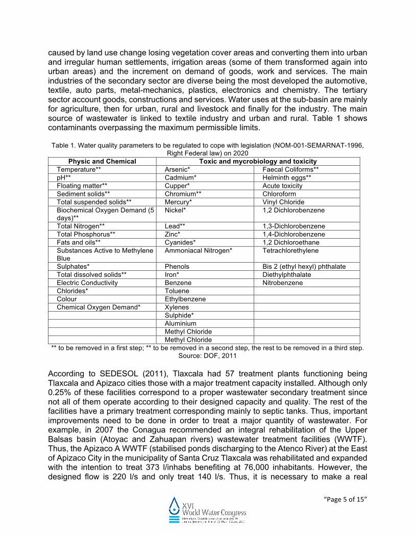
caused by land use change losing vegetation cover areas and converting them into urban and irregular human settlements, irrigation areas (some of them transformed again into urban areas) and the increment on demand of goods, work and services. The main industries of the secondary sector are diverse being the most developed the automotive, textile, auto parts, metal-mechanics, plastics, electronics and chemistry. The tertiary sector account goods, constructions and services. Water uses at the sub-basin are mainly for agriculture, then for urban, rural and livestock and finally for the industry. The main source of wastewater is linked to textile industry and urban and rural. Table 1 shows contaminants overpassing the maximum permissible limits. Table 1. Water quality parameters to be regulated to cope with legislation (NOM-001-SEMARNAT-1996,
Right Federal law) on 2020 Physic and Chemical Toxic and mycrobiology and toxicity
Temperature** Arsenic* Faecal Coliforms** pH** Cadmium* Helminth eggs** Floating matter** Cupper* Acute toxicity Sediment solids** Chromium** Chloroform Total suspended solids** Mercury* Vinyl Chloride Biochemical Oxygen Demand (5 days)**
Nickel* 1,2 Dichlorobenzene
Total Nitrogen** Lead** 1,3-Dichlorobenzene Total Phosphorus** Zinc* 1,4-Dichlorobenzene Fats and oils** Cyanides* 1,2 Dichloroethane Substances Active to Methylene Blue
Ammoniacal Nitrogen* Tetrachlorethylene
Sulphates* Phenols Bis 2 (ethyl hexyl) phthalate Total dissolved solids** Iron* Diethylphthalate Electric Conductivity Benzene Nitrobenzene Chlorides* Toluene Colour Ethylbenzene Chemical Oxygen Demand* Xylenes Sulphide* Aluminium Methyl Chloride Methyl Chloride
** to be removed in a first step; ** to be removed in a second step, the rest to be removed in a third step. Source: DOF, 2011
According to SEDESOL (2011), Tlaxcala had 57 treatment plants functioning being Tlaxcala and Apizaco cities those with a major treatment capacity installed. Although only 0.25% of these facilities correspond to a proper wastewater secondary treatment since not all of them operate according to their designed capacity and quality. The rest of the facilities have a primary treatment corresponding mainly to septic tanks. Thus, important improvements need to be done in order to treat a major quantity of wastewater. For example, in 2007 the Conagua recommended an integral rehabilitation of the Upper Balsas basin (Atoyac and Zahuapan rivers) wastewater treatment facilities (WWTF). Thus, the Apizaco A WWTF (stabilised ponds discharging to the Atenco River) at the East of Apizaco City in the municipality of Santa Cruz Tlaxcala was rehabilitated and expanded with the intention to treat 373 l/inhabs benefiting at 76,000 inhabitants. However, the designed flow is 220 l/s and only treat 140 l/s. Thus, it is necessary to make a real
“Page6of15”
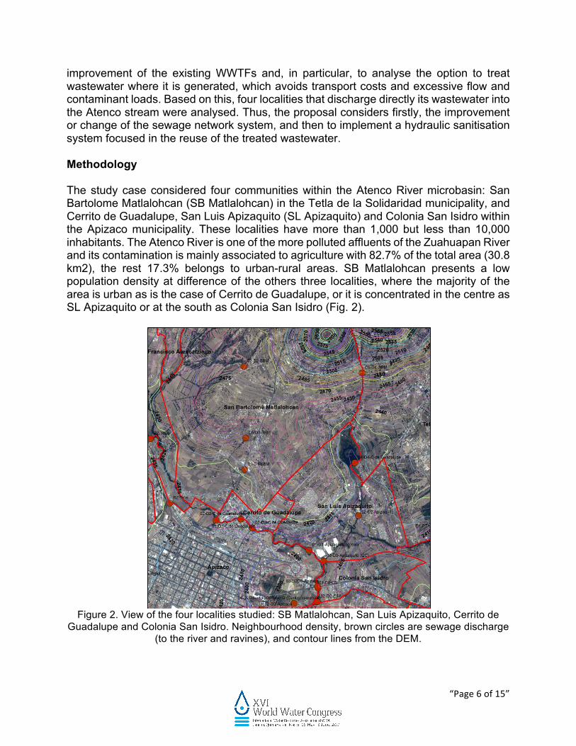
improvement of the existing WWTFs and, in particular, to analyse the option to treat wastewater where it is generated, which avoids transport costs and excessive flow and contaminant loads. Based on this, four localities that discharge directly its wastewater into the Atenco stream were analysed. Thus, the proposal considers firstly, the improvement or change of the sewage network system, and then to implement a hydraulic sanitisation system focused in the reuse of the treated wastewater. Methodology The study case considered four communities within the Atenco River microbasin: San Bartolome Matlalohcan (SB Matlalohcan) in the Tetla de la Solidaridad municipality, and Cerrito de Guadalupe, San Luis Apizaquito (SL Apizaquito) and Colonia San Isidro within the Apizaco municipality. These localities have more than 1,000 but less than 10,000 inhabitants. The Atenco River is one of the more polluted affluents of the Zuahuapan River and its contamination is mainly associated to agriculture with 82.7% of the total area (30.8 km2), the rest 17.3% belongs to urban-rural areas. SB Matlalohcan presents a low population density at difference of the others three localities, where the majority of the area is urban as is the case of Cerrito de Guadalupe, or it is concentrated in the centre as SL Apizaquito or at the south as Colonia San Isidro (Fig. 2).
Figure 2. View of the four localities studied: SB Matlalohcan, San Luis Apizaquito, Cerrito de
Guadalupe and Colonia San Isidro. Neighbourhood density, brown circles are sewage discharge (to the river and ravines), and contour lines from the DEM.
“Page7of15”
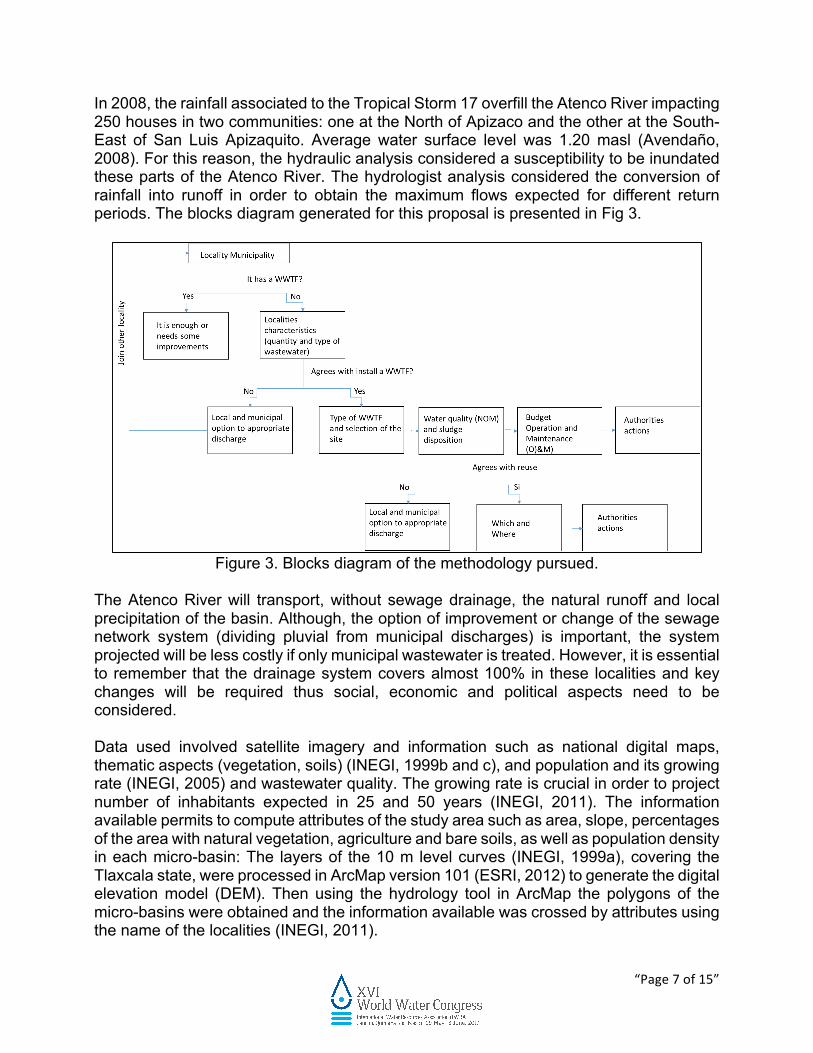
In 2008, the rainfall associated to the Tropical Storm 17 overfill the Atenco River impacting 250 houses in two communities: one at the North of Apizaco and the other at the South-East of San Luis Apizaquito. Average water surface level was 1.20 masl (Avendaño, 2008). For this reason, the hydraulic analysis considered a susceptibility to be inundated these parts of the Atenco River. The hydrologist analysis considered the conversion of rainfall into runoff in order to obtain the maximum flows expected for different return periods. The blocks diagram generated for this proposal is presented in Fig 3.
Figure 3. Blocks diagram of the methodology pursued.
The Atenco River will transport, without sewage drainage, the natural runoff and local precipitation of the basin. Although, the option of improvement or change of the sewage network system (dividing pluvial from municipal discharges) is important, the system projected will be less costly if only municipal wastewater is treated. However, it is essential to remember that the drainage system covers almost 100% in these localities and key changes will be required thus social, economic and political aspects need to be considered. Data used involved satellite imagery and information such as national digital maps, thematic aspects (vegetation, soils) (INEGI, 1999b and c), and population and its growing rate (INEGI, 2005) and wastewater quality. The growing rate is crucial in order to project number of inhabitants expected in 25 and 50 years (INEGI, 2011). The information available permits to compute attributes of the study area such as area, slope, percentages of the area with natural vegetation, agriculture and bare soils, as well as population density in each micro-basin: The layers of the 10 m level curves (INEGI, 1999a), covering the Tlaxcala state, were processed in ArcMap version 101 (ESRI, 2012) to generate the digital elevation model (DEM). Then using the hydrology tool in ArcMap the polygons of the micro-basins were obtained and the information available was crossed by attributes using the name of the localities (INEGI, 2011).

“Page8of15”
Results At the present time, the coverage of the sewage drainage at the four localities is excellent with 99%, and although there is not a confirmation that the drainage is divided between pluvial and municipal, one considered a combined drainage. Thus, in order to solve the river water pollution the proposal is to install a hydraulic sanitisation system considering the construction of a wastewater treatment facility (WWTF) focused in the agricultural reuse to stop the practise of direct discharge into the river or ravines. Looking at the project of the hydraulic sanitisation system, the growing population demands urban areas, thus it is compromised the space to build a treatment facility; except for SB Matlalohcan with a disperse population and large extension of vegetated land cover (native and irrigated). In the case of Cerrito de Guadalupe and Colonia San Isidro the available space is at the high elevation parts at the localities, opposite to where the population is settled. Almost all this land without buildings is used for irrigation activities. In SL Apizaquito, there is an available space for a WWTF at the lower elevation that corresponds to the south border with Colonia San Isidro. In a field visit, it was clearly observed some outfall points (Ramos et al., 2015), which could be connected to a primary pipeline and transport sewage to the WWTF. Thus, the proposed solution for each locality as function of the population and urban density, topography and micro-basin hydrology is: SB Matlalohcan The locality is divided into 8 micro-basins, and more or less 75% of the inhabitans (aprox. 5000) are allocated at both sides of the Federal Highway Mexico 119 (Apizaco-Tejocotal). The micro-basin that includes the highway cover the Third Section, Fourth Section, 10 de Mayo and SB Matlalohcan towns, and the out point is within Cerrito de Guadalupe. In a field visit some outfall points were localised. Here is proposed, two main collectors will be built from North to South, one at each side of the highway, and conveyed the wastewater to a WWTF that could be allocated down to the 10 de Mayo town, where is the discharge (circle brown) 01-D1, at the right side of the highway (Fig 4).

“Page9of15”
Figure 4. Proposal for allocation of the tertiary pipeline and WWTF and site for reuse in order to
mitigate river pollution coming from SB Matlalohcan. As wastewater is going to be a combined sewage, a secondary treatment could be appropriated together with disinfection. Also the sludges obtained need to be treated and disposed in a landfill maybe close to the WWTF. Finally, water treated is ready to be conveyed to the irrigation area and also, there is the possibility that the exceeding flow could be discharged into the Atenco River. It is important not to remove all nutrients in order to benefit crops; the priority should be to remove pollution. Cerrito de Guadalupe (CG) This locality has almost all its land occupied by the urban area with a population of aprox. 2500 inhab. Also, the drainage system covers almost 100%, thus tertiary and secondary drains will be collecting and discharging wastewater. During a field visit, it was observed a direct discharge into the Atenco River from three outfall points (01-D1-CG, 02-D2-CG and 03-D3-CG). In this case, drains could be connected, if they are not, to a primary pipeline and transport sewage to a WWTF. It is highly recommended to continue the main collector downstream, in order to join with the wastewater of SL Apizaquito.
“Page10of15”
San Luis Apizaquito This locality has a population of aprox. 6000 inhab., but almost all the urban settlement is allocated at the centre of the locality. Three outfall points: 01-D1 and 03-D3-Apizaquito along the Atenco River, and 02-D2-Apizaquito at the Texcalac stream were detected. Thus, the suggestion here is to install a primary pipeline to collect the secondary drains along the Atenco River, if this does not exist, and other tertiary pipeline that collect all the sewage coming to 02-D2 Apizaquito (Centre-Easth). In particular, this second collector could end into a WWTF within S L Apizaquito and the wastewater treated could be used to irrigate the left bank of the Texcalac stream. Looking at the main collector along the Atenco River, the best position to install a WWTF is before the confluence with the Texcalac stream, upstream the industry located just at the confluence. However, this is a site that has been affected by floods since it has the minimum contour line in 2395 masl. The proposal here is to connect the main collector coming from Cerrito de Guadalupe with the one in this locality (more or less 50% of the wastewater generated) and to evaluate the possibility to join it with the one that will collect wastewater produced in Colonia San Isidro. Colonia San Isidro (CSI) Colonia San Isidro with a population aprox. of 2419 inhab., as well as the other localities has outfall points: 01-D1-CSI and 02-D2-CSI. This locality is divided horizontally by the Highway 136 (Huamantla-Apizaco) being the main urban area allocated at the South (left side of the highway). The gravitational flow goes from east to the west being the lower elevation at the border with the City of Apizaco with 2395 masl. Due to this condition and to the fact that the two outfalls are allocated along the Atenco River at the south of the locality and in this section is not available space to build a WWTF. The proposal is to connect these outfall to a main collector, if this is not, and the main collector coming from Cerrito de Guadalupe and San Luis Apizaquito to join this one of Colonia San Isidro. Moreover, this main collector is suggested to be continued until the WWTF Apizaco A, which is allocated in San Miguel Contla that is part of the Metropolitan Zone of Apizaco at the East side. Proposal The four localities were analysed as function of the topography, urban density, municipality belonging (social, economic and environmental aspects), landscape, wastewater quality, existing drainage system, among other conditions. The information available was feed in a Geographical Information System (GIS) and also, raster information was used such as satellite images and DEM. Satellite imagery allows to analyse the loss of land cover, for example native vegetation into urban areas or into agricultural lands. Also, permits to validate the hydraulic simulation to estimate those susceptible areas to be inundated. Thus, the proposal is to construct: • One main collector at each side of the highway, whether it this does not exist, and a
WWTF in the same locality of San Bartolome Matlalohcan . In the case that the main

“Page11of15”
collector exist, it is recommended to review its capacity and conditions and if it is necessary to improve them.
• One main collector, whether this does not exist, to convey wastewater from Cerrito de Guadalupe, San Luis Apizaquito and Colonia San Isidro, and its disposition in to the Apizaco A WWTF allocated in the town of San Miguel Contla at the municipality of Santa Cruz Tlaxcala (Fig 5). This WWFT will need to be reviewed since theoretically a rehabilitation increased the designed flow from 220 to 373 l/s, in order to benefit almost 76,000 inhabitants, but only it is reported to be treated 140 l/s. If one considers that the Apizaco and San Miguel Contla population it is around 56,000 inhab., and the main collector proposed implies no more than 10,000 inhab., this means an additional flow of 20l/s. This flow plus the 140 l/s is lower than the original designed flow (220 l/s).
Figure 5. Proposal for allocation of the tertiary pipeline and WWTF in order to mitigate river pollution coming from Cerrito de Guadalupe, San Luis Apizaquito and Colonia San ISidro.
Table 2 summarise the main characteristics of the main collectors computed based on the component method using cost information abstracted from actual work. This method allows the handling of complete constructive phases, for example foundation, structure, sanitary installation, etc. (Varela, 2009).
Table 2. Some characteristics of the main collector proposed.

“Page12of15”
Locality Average Flow
Terrain level, m Longitude No. Cost
Q, l/s Initial Final m wells pesos MX SB Matlalohcan 11.87 2510 2430 3125 27 $2,622,015.4
C Guadalupe, SL Apizaquito, C San Isidro
19.19 2409 2387 5190 44 $4,335,681.4
Additional to the pipeline cost, it is required to consider the cost for building the WWFT for S B Matlalohcan and the rehabilitation of the Apizaco A WWTF. The main purpose of any river restoration is to provide benefits to the society and environment, and in this case to avoid the continue pollution of the river and protect human health as well as to provide some recreational activities that could have had the river before its pollution. It is important that policymakers consider an integrated operation of the WWTF in the river basin as Morera et al. (2015) have noticed, and one key issue is the role associated to the building of the pipeline and the final benefits expected. Sometimes, the cost of this collector could reduce the benefits of connecting the environment with the O&M. Some questions need to be answered, e.g. Who is going to pay the construction of the pipeline? Who are the direct or indirect beneficiaries of the collection, convey and treatment of wastewater? This could imply conflicts that need to be solved before any implementation of the proposal. However, the society is not always compromised to cope with the cost of the infrastructure that is determinant to get a proper treatment facility and then the cost for the O&M. Thus, costs and benefits need to be evaluated by the decision makers and, particularly, by the politicians. Conclusions A hydraulic sanitisation system is part of the requirements needed to maintain a healthy river or to provide a proper management at river basin scale. However, it is not only necessary to look at the evident benefits such as recovering of the riverine ecosystem, recreational activities, source of water, etc., but also it is required for authorities to pay attention to the inhabitant’s necessities in order to avoid conflicts associated to the cost and ownership of the wastewater treated. This proposal is a good option for these towns to start the sanitisation of their ecosystem, the sewerage pipelines need to be implemented by authorities and according to their capability to supply a correct O&M for all the system. The system involves the collection, conveyance, treatment and final disposal generating a water quality according to the legislation for irrigation reuse. The result of the interaction of all the mentioned processes in an unstable region with social, municipal and regional conflicts, and also environmental crisis that reduce water availability (treated or not) or may a non-uniform distribution of the economic benefits could increase social instability. The results show that it is possible to guarantee a zero discharge into the Atenco River, and although during the rainy season it could be expected some discharge of wastewater treated into the river, an integrate river management can be achieved.
“Page13of15”
References Anaya, G. M. (1998) Problemas de erosión y desertificación en suelos de América Latina.
Chapingo, Estado de México. Universidad Autónoma Chapingo (UACH). Avendaño J.C. (2008) Provoco la lluvia afectciones en cuatro municipios este martes:
IEPC. La Jornada de Oriente, 30 de julio de 2008 Web page consulted in March 2015] http://www.lajornadadeoriente.com.mx/2008/07/30/tlaxcala/tla205.php
DOF (2011). Declataroria de clasificación de los ríos Atoyac y Xochiaco o Hueyapan, y sus afluentes. Diario Oficial de la Federación, 6 de julio de 2011
ESRI (2012) ARcMap 10.1, Esri, Inc. License type: Advanced INEGI (1999a) Ortofoto digital. Fuente: fotografías aéreas escala 1:75,000 de mayo de
1999. Proyección: UTM. Datum: ITRF92. Elipsoide: GRS 80. Dimensiones del pixel X,Y: 1.5 metros. Productos geográficos básicos digitales. Instituto Nacional de Estadística Geografía e Informática, México.
INEGI (1999b) Estratificación de datos en formato DXF de los conjuntos de datos vectoriales. Carta topográfica, escala 1:50,000. Versión 4. Productos geográficos básicos digitales. Instituto Nacional de Estadística Geografía e Informática, México.
INEGI (1999c) Conjunto de datos vectoriales. Localidades del Estado de Tlaxcala. Productos geográficos básicos digitales. Instituto Nacional de Estadística Geografía e Informática.
INEGI (2005) Censo General de Población y Vivienda 2005. Instituto Nacional de Estadística Geografía e Informática, México.
INEGI (2006) Anuario Estadístico Tlaxcala, tomo I y II, Aguascalientes, Ags. INEGI (2011) Censo de Población y Vivienda 2010. [Web page consulted in November
2014] http://www.beta.inegi.org.mx/proyectos/ccpv/2010/ Kauffman J.B., Beschta R.l., Otting N. & Lytjen D. (1997) An ecological perspective of
riparian and stream restoration in the western United States. Fisheries, 22, 12-24. Morera, S. Comas, J. Poch, M. Corominas, L. (2015) Connection of neighbouring
wastewater treatment plants: economic and environmental aspects. Journal of Cleaner Production, 90: 34–42. DOI:10.1016/j.clepro.2014.11.047.
Murdock J.N. (2008) Stream Restoration. In Applications in Ecological Engineering, Editor Sven Erik Jorgensen, Elsevier 2009. ISBN: 978-0-444-53448-4
Palmer M.A., Bernhardt E.S., Allan J.D., Lake P.S., Alexander G., Brooks S., Carr J., Clayton S., Dahm C.N., Follstad Shah J., Galat D.L., Loss S.G., Goodwin P., Hart D.D., Hassett B., Jenkinson R., Kondolf G.M., Lave R., Meyer J.L., O’donnell T.K., Pagano L. & Sudduth E. (2005) Standards for ecologically successful river restoration, Journal of Applied Ecology, 42, 208–217. doi: 10.1111/j.1365-2664.2005.01004.x
Palmer M.A., Menninger H.L. & Bernhardt E. (2010) River restoration, habitat heterogeneity and biodiversity: a failure of theory or practice? Freshwater Biology, 55 (Suppl. 1), 205–222. doi:10.1111/j.1365-2427.2009.02372.x
Ramos J.G., Ortiz Martinez V.M., Guzman-Castellon E.H. & Gracia Sanchez J. (2015). Estructuras, colectores marginales y zonas de riego en la cuenca del Atoyac. Elaborado para CONAGUA, México D.F.
Roni, P, TJ Beechie, RE Bilby, FE Leonetti, MM Pollock, GP Pess (2002). A review of stream restoration techniques and a hierarchical strategy for prioritizing restoration in Pacific Northwest watersheds. North American Journal of Fisheries Management, 22, 1-20

“Page14of15”
SEDESOL (2011) Atlas de Peligros Naturales del Municipio de Apizaco, Tlaxcala, Apizaco, Tlaxcala
SEMARNAT (2003) NOM-001-ECOL-1996. Límites máximos permisibles de contaminantes en las descargas de aguas residuales y bienes nacionales. Secretaría de Medio Ambiente y Recursos Naturales. Diario Oficial de la Federación, México. 23 de abril, 2003.
Varela L. (2009). Ingeniería de Costos Teoría y Práctica en Construcción. Versión Abreviada. Varela-Ingeniería de Costos. [Web page consulted in June 2015] http://www.biicsa.com.mx/css/images/CostosDeConstruccionParaArquitectosEIngenieros.pdf
Wohl E. (2014). Rivers in the Landscape. Science and Management. John Wiley and Sons Lt. ISBN: 978-1-118-41483-5