water security and achievement of sdg 6 in context...
TRANSCRIPT

Water Security and achievement of SDG 6
in context of the changing climate in Coastal Souhwest
Dr Ainun Nishat C3ER, BRAC University

PROJECT BACKGROUND • A project was taken to recommend water governance structure in local context
that will be inclusive and sustainable. • A common issue across the country is centralized institutions follow a top-down
approach in the decision-making on water issues with almost no community engagement.
• Key issues South-West Bangladesh are impacted by floods, water logging, droughts, reduction in water availability, over-extraction, water contamination.
• All of which is further exacerbated by erratic climatic conditions and lack of pro-poor water governance systems.
• Competition of demand of water for the water supply and sanitation, agriculture, industry, fisheries and wildlife, navigation, hydropower and recreation is accelerating day by day.

Activities
• Stakeholder Analysis • Pani Somonnoy Committee Formation • Vulnerability Assessment • Problem analysis and Policy Brief • Past and Present Condition of Rivers • Water management plan

Satkhira District: At a Glance Socio Economic
Information (BBS,2011)
Total population
19,85,959
Male 9,82,777 Female 10,03,182 Urban 1,40,572 Other Urban 57,044 Rural 17,88,343 Annual growth rate
0.62
Sex Ratio 98 Households (HH)
4,69,890
Average HH Size
4.21
Area sq. km 3817.29 Density per sq. km
520
Literacy (%) 52.1
Geographical Information (BBS,2011)
Upazila/Thana
7
Union 79 Mauza 916 Village 1,440 Paurashava 2
Satkhira district lies between 21º36' and 22º54' north latitudes and between 88º54' and 89º20' east longitudes Temperature
Maximum 35.5°C
Minimum 12.5°C
Rainfall
Annual rainfall 1710 mm

SHYAMNAGAR UPAZILA • Population - 300,000 • People living in Shyamnagar,
Satkhira district, Bangladesh, face severe climate induced hazards.
• The district is surrounded by a complex river network consisting of: 1. Kholpetua 2. Kalindi 3. Madar 4. Kopotakkho.

Unions of Shyamnagar Upazila
Bhurulia Kashimari Shyamnagar Sadar Ishwaripur Burigowalini Kaikhali
Munshiganj Nurnagar Padmapukur Ramjan Nagar Atulia Gabura

STAKEHOLDER ANALYSIS

Computation of level of influence, impact and current level of support of stakeholders in water sector

Position of each stakeholder
considering their influence,
impact and support in the transboundary water issues in
Bangladesh

PANI SHOMONNOY COMMITTEE
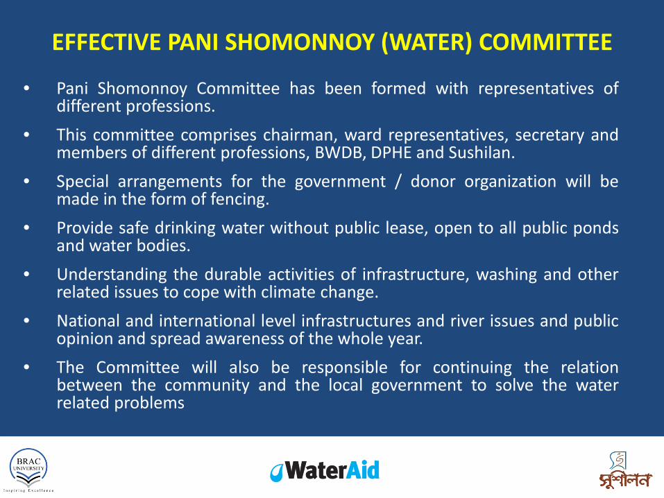
EFFECTIVE PANI SHOMONNOY (WATER) COMMITTEE
• Pani Shomonnoy Committee has been formed with representatives of different professions.
• This committee comprises chairman, ward representatives, secretary and members of different professions, BWDB, DPHE and Sushilan.
• Special arrangements for the government / donor organization will be made in the form of fencing.
• Provide safe drinking water without public lease, open to all public ponds and water bodies.
• Understanding the durable activities of infrastructure, washing and other related issues to cope with climate change.
• National and international level infrastructures and river issues and public opinion and spread awareness of the whole year.
• The Committee will also be responsible for continuing the relation between the community and the local government to solve the water related problems

PANI SHOMONNOY COMMITTEE
Committee Members
Address/ Professions Padmapukur
Kashimari Gabura Nurnagar Kaikhali Ramjannnagar
Chairman UP 1 1 1 1 1 1 3 - Ward Representative members
Wards 1-3, 4-6, 7-9 3 3 3 3 3 3
2 - Ward Representative members
Ward 1 to 9 9 9 9 9 9 9
Secretary UP 1 1 1 1 1 General Members
Freedom Fighter, Teacher, Imam, Farmer, Worshiper, BWDB, DPHE, Sushilan and others
15 18 21 22 19 19
Total No. of Members 29 32 35 35 33 33

PROBLEM & VULNERABILITY ANALYSIS

• Located in Southwest part of the country and can be considered as one of the highest disaster affected site of Bangladesh.
• Due to consecutive disastrous calamities, both environmental and socio-economic condition of the peoples living in these areas are affected.
• Salinity intrusion, Unhygienic water resources, Change in cropping pattern, Water logging, Ecosystem and biodiversity loss, Harmful impact on Sundarbans etc. are major environmental issues of ShyamnagarUpazila.
ENVIRONMENTAL CONDITION IN SHYAMNAGAR UPAZILA
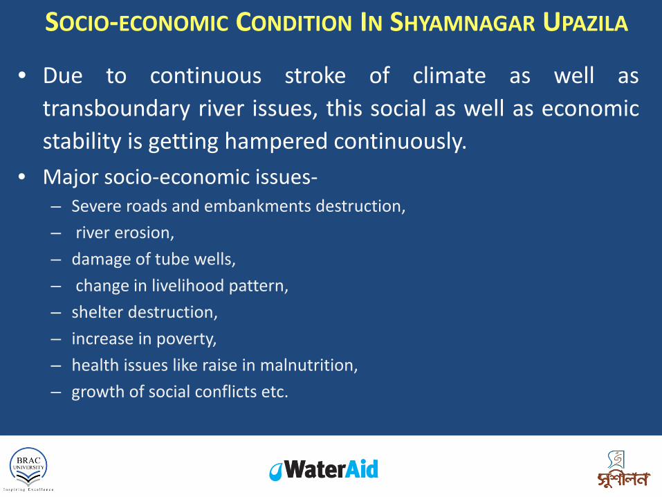
• Due to continuous stroke of climate as well as transboundary river issues, this social as well as economic stability is getting hampered continuously.
• Major socio-economic issues- – Severe roads and embankments destruction, – river erosion, – damage of tube wells, – change in livelihood pattern, – shelter destruction, – increase in poverty, – health issues like raise in malnutrition, – growth of social conflicts etc.
SOCIO-ECONOMIC CONDITION IN SHYAMNAGAR UPAZILA

SEASONAL CALENDAR (AS PERCEIVED BY FARMERS)
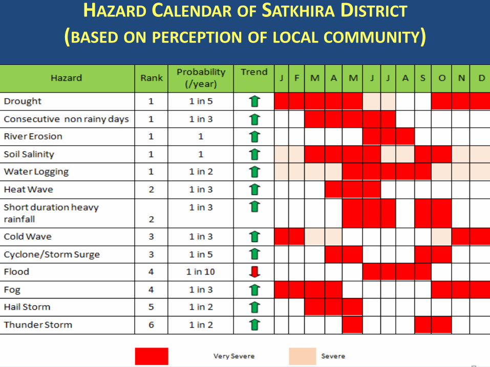
HAZARD CALENDAR OF SATKHIRA DISTRICT (BASED ON PERCEPTION OF LOCAL COMMUNITY)

VULNERABILITY DRIVERS AND IMPACTS
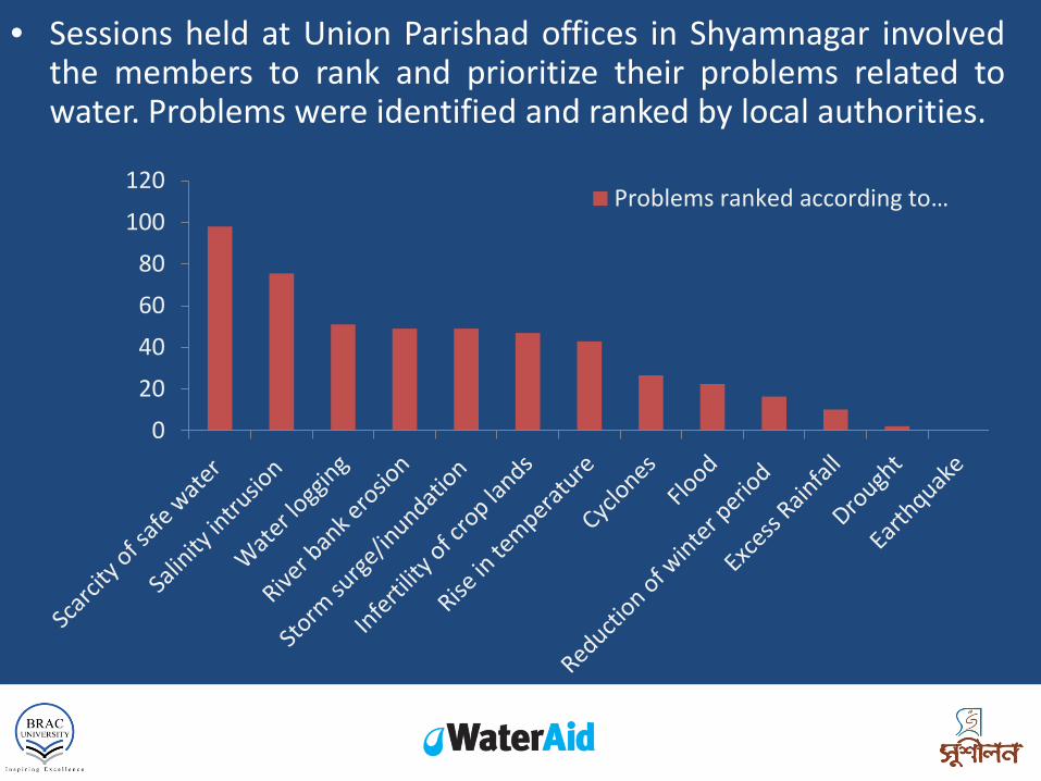
• Sessions held at Union Parishad offices in Shyamnagar involved the members to rank and prioritize their problems related to water. Problems were identified and ranked by local authorities.
0
20
40
60
80
100
120Problems ranked according to…

1. Scarcity of safe water – The area faces scarcity of safe water for various household
purposes. – Water used from ponds and rivers for drinking and cooking
purposes are not 100% hygienic and sources are not sustainable especially during dry seasons when water reduces and there is no rainfall.
– Sufficient water tanks are not available and pipeline systems are not installed.
– Irrigation requires a huge amount of water thus drinking water from ponds need to be shared with water for agricultural needs.
MAJOR PROBLEMS

2. Salinity intrusion – Ghers are not separated from agricultural lands thus
leaching caused saline water to be infused in the nearby areas. This is causing salinity to increase in ponds and groundwater.
– Intensive irrigation caused ground water to be extracted from shallow tubewells, thus contributing to salinity intrusion.
– Transboundary river issues also impact salinity intrusion in this region.
MAJOR PROBLEMS

3. Water logging – Considerable parts of the region have been experiencing
water logging almost every year since 2000 and water can often take up to six months to recede.
– Paddy cultivation is done inside shrimp and crab ghers, in leased out sections cut out in the middle of the ghers.
– When water rises, it is kept in the crop land as gher owners refuse to let water pass onto their lands.
– Unavailability of sluice gates is also a major reason of water logging.
MAJOR PROBLEMS

4. River bank erosion – Many have had to move their homes many times
when river banks eroded and destroyed nearby areas.
– This takes a toll on their economic well-being as relocating and rehabilitation needs financial support.
– There are some sluice gates in the area but most are inactive.
MAJOR PROBLEMS

5. Cyclone/Storm surge/Inundation – The area suffers from frequent storm surges and
cyclones. – Inundation becomes difficult to deal with as people
do not have proper access to safe houses and shelters.
– Infrastructural and development deficit in the area also are major reasons that hamper livelihoods during natural disasters.
MAJOR PROBLEMS

Impacts of upstream
water diversion to Bangladesh

POLICY GAP ANALYSIS

SECTORAL POLICIES • National Water Policy, 1999 • Nation Water Management Plan, 2001 • Coastal Zone Policy, 2005
Water
• National Agriculture Policy, 2013 • Bangladesh Climate Change Strategy and Action plan (BCCSAP), 2009 • National Adaptation Plan of Action (NAPA), 2015
Agriculture
• National Policy for Safe Water Supply and Sanitation, 1998 • National Water Policy, 1999
Water supply and Sanitation
• National Health Policy, 2011 Health
• National Disaster Management policy, 2015 • Standing Orders Disasters- LGED, 2010
Disaster management

PROBLEMS
POLICIES
GAPS & RECOMMEND
ATIONS
Transboundary river impacts in local
water management
National Water Management Plan (SECTION 1.6.4.)
Treaties securing Bangladesh’s
share of the flows of the other 53 transboundary rivers should
ideally be brought into
place.
Salinity rise Coastal Zone Policy
(SECTION 4.1. b.)
Enhance standard of living
of coastal communities by
investing in different sectors
like marine fisheries, salt production,
shrimp culture, crab culture, etc.
Land Use conflicts National Agriculture
Policy (SECTION 12)
Appropriate measures will be taken to stop the
trend of using agricultural land
for non-agricultural
purpose such as private
construction in the light of the Land
Policy of the government.
Policy Update Salinity Reduction Land Use Percentage

PROBLEMS
POLICIES
GAPS & RECOMMEND
ATIONS
Lack of proper Disaster Response
National Policy for Water
Supply & Sanitation (SECTION 8.1.7 )
During natural disaster, necessary measures shall be taken on an emergency basis so that people have access to safe water and do not have to drink contaminated water.
Change of water scenarios due to increasing climate change
Coastal Zone Policy (SECTION 4.8.3. a., SECTION 4.8.3. b., SECTION 4.8.3. c.,
SECTION 4.8.3. d.)
Support upgrading of technology and institutional strengthening for enhancing capacity Implementation of adaptive measures identified in relation to climate change for coastal zone Efforts shall be made to continuously maintain sea-dykes An institutional framework for monitoring/ detecting sea level rise shall be made
Policy Update Policy Update

PROBLEMS
POLICIES
GAPS & RECOMMEND
ATIONS
River Bank Erosion National Water
Management Plan (VOLUME 1 - SECTION 7)
Strategies for river bank erosion will be reviewed in the light of experience and studies are on-going relieving dry season shortages from the Ganges.
Increase of water borne and skin
diseases
National Heath Policy (SECTION - Policy
strategies)
Prevention of disease and health promotion will be emphasized to achieve the basic objective of Health for all
Overuse of Groundwater
National Water Policy (SECTION 4.3. C., SECTION 4.7. b., SECTION 4.7. c.)
Government will regulate the extraction of water in the identified scarcity zones with full public knowledge Encourage future groundwater development for irrigation Improve efficiency of resource utilization
Tree Plantation Policy Update SW and GW Distribution

INVENTORY OF COMPLETED WORKS

• Numerous development projects have been undertaken in the Shyamnagar region related to water management and water issues by different organizations such as- – Bangladesh Water Development Board (BWDB) – Bangladesh Climate Change Trust Fund (BCCTF) – Oxfam – Local Government Engineering Department (LGED) – Nowabenki Gonomukhi Foundation (NGF)

FUTURE WATER MANAGEMENT STRATEGY

– Excavate ponds to improve recharge and to increase rainwater yield – Maintain ponds to stop them from silting up – Storage facilities can be improved to enhance the availability of
harvested surface water – Roof water harvesting – Conduct fog collection tests for fog water harvesting – Additional wells are being constructed – Promote the use of treadle pumps to limit water extraction – Educate people better on the causes and effects of the water crisis,
as well as what they can do to help maintain water sources – Incentivize innovation in the fields of water recycling, conservation
and consumption
Management plan for scarcity of safe water

– Avoid drilling excessively deep within areas proximal to the coast.
– Close unusable (e.g. very low yielding) wells or wells that are no longer needed. Abandoned wells, open boreholes, wells with failing surface seals or corroded casings can provide a flow pathway for aquifer cross-contamination and the vertical movement of saline groundwater.
– Irrigation method and adequate drainage systems – Deep tillage is required to ensure internal drainage as it is
very important to break up the restraining layer that delays water movement
Management plan for salinity intrusion

– Establishment of shallow interceptor drains – Discharging the congested water by installation of drainage pump – Minimizing the accumulation of congested water through rain water
harvest – Downing water table by groundwater recharge – Lowering groundwater levels through deep tube wells – Subsurface drainage systems that consist of open and pipe drains – Dry drainage that involves the allocation of areas of fallow land,
which operate as evaporative sinks drawing a stable flux of water (and salt) from irrigated areas
– Plantation or stands of halophytes (salt-loving plants) those can transpire sufficient water to lower water tables
– Windmills could also be used to pump water into the embanked river to prevent water logging of the lowlands (polders) behind them
Management plan for water logging

– Establish basic types of structures to stabilize a bank such as different filter structures and wall structures. Filter structures reduce the level of the wave's strength while keeping soil from passing through to the water. Wall structures are impervious vertical walls that separate the natural shoreline from water and wave action.
– Plant trees along banks to strengthen soil and prevent from eroding
– Planting of trees in a drainage basin to increase interception and storage while reducing surface run off. This reduces a river’s discharge and so makes it less likely to flood.
River bank erosion Management

– Carry out campaigns for local community to raise awareness regarding climate change impacts and flood risk management
– Train and build capacity of the people to be able to take proper measures for water management after disasters
– Build riverside embankments to effectively stop water spilling over onto adjacent land
– Educate local community on importance of Sundarban and how it acts as barrier to cyclones
– Establish cyclone shelters and improved early warning systems
– Improve linkage between local government and community for effective distribution of and access to relief services
Cyclone/Storm surge/inundation Management

SDG 6 INDICATORS 6.1. By 2030, achieve universal and equitable access to safe and affordable
drinking water for all. 6.2. By 2030, achieve access to adequate and equitable sanitation and hygiene for
all and end open defecation, paying special attention to the needs of women and girls and those in vulnerable situations.
6.3. By 2030, improve water quality by reducing pollution, eliminating dumping and minimizing release of hazardous chemicals and materials, halving the proportion of untreated waste water and substantially increasing recycling and safe reuse globally.
6.4. By 2030, substantially increase water-use efficiency across all sectors and ensure sustainable withdrawals and supply of freshwater to address water scarcity and substantially reduce the number of people suffering from water scarcity.
6.5. By 2030, implement integrated water resources management at all levels, including through transboundary cooperation as appropriate.
6.6. By 2020, protect and restore water-related ecosystems, including mountains, forests, wetlands, rivers, aquifers and lakes.

OUTCOMES LINKED TO SDG 6 INDICATORS
PROJECT OUTCOMES SDG 6 INDICATORS
Management plan for scarcity of safe water 6.1, 6.3, 6.4
Management plan for salinity intrusion 6.1, 6.4
Management plan for water logging 6.5, 6.6
River bank erosion Management 6.5, 6.6
Cyclone/Storm surge/inundation Management 6.5

Outcomes linked to Other SDG Good Health and Well-Being- SDG3 Sustainable Cities and Communities-SDG11 Responsible Consumption and Production-
SDG12 Climate Action-SDG13 Life on Land-SDG15 Partnership for the Goals-SDG17

THANK YOU