waterbird survey at lake mackay - epa wa
TRANSCRIPT

Lake Mackay Sulphate of
Potash Project
Waterbird Survey at
Lake Mackay
Prepared for:
Agrimin Ltd
July 2017
360 Environmental Pty Ltd
Disclaimer
This report is issued in accordance with, and is subject to, the terms of the contract between the Client and 360
Environmental Pty Ltd, including, without limitation, the agreed scope of the report. To the extent permitted by law, 360
Environmental Pty Ltd shall not be liable in contract, tort (including, without limitation, negligence) or otherwise for any
use of, or reliance on, parts of this report without taking into account the report in its entirety and all previous and
subsequent reports. 360 Environmental Pty Ltd considers the contents of this report to be current as at the date it was
produced. This report, including each opinion, conclusion and recommendation it contains, should be considered in the
context of the report as a whole. The opinions, conclusions and recommendations in this report are limited by its agreed
scope. More extensive, or different, investigation, sampling and testing may have produced different results and therefore
different opinions, conclusions and recommendations. Subject to the terms of the contract between the Client and 360
Environmental Pty Ltd, copying, reproducing, disclosing or disseminating parts of this report is prohibited (except to the
extent required by law) unless the report is produced in its entirety including this cover page, without the prior written
consent of 360 Environmental Pty Ltd.
© Copyright 2017 360 Environmental Pty Ltd ACN 109 499 041
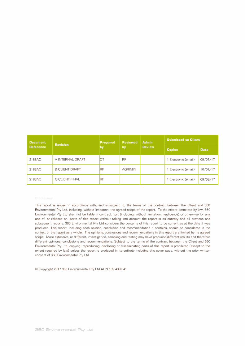
Document
Reference Revision
Prepared
by
Reviewed
by
Admin
Review
Submitted to Client
Copies Date
2188AC A INTERNAL DRAFT CT RF 1 Electronic (email) 09/07/17
2188AC B CLIENT DRAFT RF AGRIMIN 1 Electronic (email) 10/07/17
2188AC C CLIENT FINAL RF 1 Electronic (email) 09/08/17
2188AC Waterbird Survey at Lake Mackay
Agrimin
360 Environmental Pty Ltd i
Executive Summary
Agrimin Limited (Agrimin) requires a number of baseline biological assessments to be
carried out at its Lake Mackay Sulphate of Potash (SOP) project. The SOP project
comprises nine tenements (all in Western Australia) covering the majority of Lake
Mackay over a total area of 2,560 km2. The SOP project has indicated mineral resources
of 4.3 million tonnes and inferred mineral resources of 18.9 million tonnes of SOP (based
on specific yield) at a potassium concentration of 3,603 mg/L of brine. The mineral
resources are estimated on the basis of drainable brine volume from surface to an
average depth of only 24.7 m.
Lake Mackay is the 4th largest lake in Australia dominated by an episodically inundated
shallow lake bed as well as surrounding freshwater claypans. It is located on the Western
Australia (WA) – Northern Territory (NT) border. Following a major rainfall event during
summer-autumn 2001, an aerial survey found that the lake was of national and
international significance for waterbird populations (26 waterbirds species, >40,000
individual birds). It was also shown to be a significant site for breeding of Banded Stilt
Cladorhynchus leucocephalus, an Australian-endemic shorebird, with more than 4,400
juvenile birds observed at two sites. In December 2016, a major rainfall event (426 mm)
and subsequent inundation created an opportunity to assess the status, abundance and
significance of waterbirds in the SOP project area. Arid-zone wetlands such as Lake
Mackay are always drying or flooding which stimulates movements of waterbirds in
response to resource abundance and depletion.
Waterbirds and other birds were surveyed at a total of 62 georeferenced sites during 14-
17 April 2017, 114-117 days after the rain event. This included 17 ground survey sites,
10 on Lake Mackay and seven at claypans. Total ground survey effort was 20 hrs and 47
mins, including 11 hrs and 59 mins at the 10 Lake Mackay sites and 8 hrs and 48 mins at
the seven claypan sites. At each ground site, waterbirds were observed with binoculars
and a spotting scope and counted or numbers estimated. The presence and absence of
waterbirds on Lake Mackay was recorded at georeferenced sites during all general and
targeted helicopter flights over Lake Mackay and associated claypan wetlands
(approximately 600 km of flights in total).
A total of 52 bird species were recorded including 26 waterbird species (12 shorebirds
and 14 other waterbirds) and 26 landbird species. On Lake Mackay, waterbird diversity
was very low (7 species) and at very low abundance. Only 682 individual waterbirds were
recorded including 540 shorebirds, comprised of 252 Red-necked Stints Calidris
ruficollis, 235 Banded Stilts (including one flock of 190 birds), 47 Red-capped Plovers
Charadrius ruficapillus and six Sharp-tailed Sandpipers Calidris acuminata. All
shorebirds were observed actively foraging at the shoreline, or mostly well offshore (>1
km) in typically very shallow water (around 3-15 cm). There was a striking difference in
the productivity and relative density of waterbirds on Lake Mackay compared to nearby
claypans. Claypans hosted a species-rich and high density of shorebird and other

2188AC Waterbird Survey at Lake Mackay
Agrimin
360 Environmental Pty Ltd ii
waterbird communities, with 2,591 individual waterbirds from 26 species (in 66.8 ha).
The density of waterbirds on claypans compared to Lake Mackay was approximately 680
times greater (3,878.7 versus 5.7 birds/km2). For example, one 21 ha claypan site (C7)
hosted at least 888 individual waterbirds. No major breeding colonies of Banded Stilt or
other shorebirds were recorded on Lake Mackay or associated islands. Several
shorebirds and waterbirds had bred successfully at claypans with tens of individual
juvenile Black-winged Stilt, Whiskered Tern Chlidonias hybrida and Australian Gull-billed
Tern Gelochelidon macrotarsa observed. A few juvenile plumaged Banded Stilt were
seen foraging on Lake Mackay and may have bred locally. Including secondary data, a
total of at least 40 waterbird species have been recorded at Lake Mackay including 16
shorebird species and 24 other waterbirds.
There were major differences in the abundance of waterbirds between observations in
September–October 2001 and the present survey. This is best explained by the
quantum, spread and timing of rain and associated patterns of evaporation and also
electrical conductivity. In 2001 there was a higher total rainfall (808 mm) spread out over
3 months in late summer, whereas in December 2016 the rainfall was a singular event
(425 mm) in early summer. Inundation in 2001 was presumably much greater with
reduced surface water evaporation because water depth was higher in September 2001
compared to April 2017 (40 cm versus c.10-15 cm), with electrical conductivity 1.6 to 3
times greater in 2017 compared to 2001. Shorebirds such as the Banded Stilt have been
found to move away from wetlands when electrical conductivity reaches 127,000 µS/cm
(micro Siemens per cm). In April 2017, electrical conductivity in Lake Mackay was
140,000 to 262,000 µS/cm (about 3-5 times greater than seawater).
An anticipated boom in primary productivity which would attract and maintain large
numbers of waterbirds on Lake Mackay had largely busted at 114-117 days after a major
rainfall event. Lake Mackay was found to support low numbers of relatively few
waterbird species and no major breeding colonies were recorded. Flocks of 10,000s of
waterbirds may have been present on Lake Mackay up until around February-March
2017, but had moved during summer as water levels and food availability plummeted and
electrical conductivity increased. Many waterbird species obviously use both saline
habitats on Lake Mackay as well as claypans, but specialized species such as Banded
Stilt depend on saline lakes for breeding. This study highlights claypans as habitat
supporting waterbird communities of high conservation significance. Despite their small
areal extent these held a diverse range and large numbers of waterbird including
Environment Protection and Biodiversity Conservation Act 1999 (EPBC Act) listed
species such as the Australian Painted Snipe, Rostratula australis (Australia’s rarest
waterbird), and supported breeding by several waterbird species. Only seven claypans
were surveyed but imagery shows that 1,000s of claypans occur around Lake Mackay
including at least 30 greater than 8 ha.

2188AC Waterbird Survey at Lake Mackay
Agrimin
360 Environmental Pty Ltd iii
Table of Contents
1 Introduction .................................................................................................. 1
1.1 Lake Mackay Sulphate of Potash Project .............................................................. 1
1.2 Survey Objectives .................................................................................................. 1
2 Environment ................................................................................................. 3
2.1 Lake Mackay .......................................................................................................... 3
2.2 Claypans south of Lake Mackay ............................................................................ 3
2.3 Boom and Bust ecology of waterbirds in inland Australian wetlands ..................... 4
2.4 Previous waterbird-bird surveys at Lake Mackay .................................................. 4
2.5 The December 2016 rainfall event and climate ...................................................... 7
3 Methods ....................................................................................................... 8
3.1 Secondary sources of waterbird data from Lake Mackay ...................................... 8
3.2 Survey period, access and sites ............................................................................. 8
3.3 Ground and Aerial Waterbird Surveys ................................................................. 10
4 Results ........................................................................................................13
4.1 Broad site and water characteristics .................................................................... 13
4.2 Overall bird and waterbird patterns ..................................................................... 13
4.3 Shorebirds and waterbirds of Lake Mackay ......................................................... 16
4.4 Shorebirds and waterbirds of Lake Mackay claypans .......................................... 16
4.5 Conservation and migration status of waterbirds at Lake Mackay ...................... 16
4.6 Evidence of waterbird breeding on Lake Mackay ................................................. 19
5 Discussion ...................................................................................................21
5.1 The boom that went bust – waterbird abundance in 2017.................................... 21
5.2 The total number of waterbird species at Lake Mackay....................................... 23
5.3 Boom-bust, rain, flood and evaporation: comparison to the NT government waterbird survey of 2001 ................................................................................................ 23
6 Conclusions .................................................................................................26
7 References ..................................................................................................27
8 Limitations ...................................................................................................29

2188AC Waterbird Survey at Lake Mackay
Agrimin
360 Environmental Pty Ltd iv
List of Tables
Table 1. Waterbird species recorded previously in the Lake Mackay region .................... 5
Table 2. Summary characteristics of the 17 ground survey sites on Lake Mackay and
nearby claypans. ................................................................................................. 11
Table 3. Summary characteristics of the 17 ground survey sites on Lake Mackay and
nearby claypans. ................................................................................................. 13
Table 4. Counts of all waterbirds recorded in 2001 (source: Duguid 2005) and in 2017
and their conservation and migratory status. ...................................................... 17
List of Figures
Figure 1: Survey Area ....................................................................................................... 2
Figure 2: Waterbird Survey Sites ...................................................................................... 9
Figure 3: Waterbird Sightings ......................................................................................... 15
Figure 4. Breeding phenology of hypothetical colonies of Banded Stilt at Lake Mackay
following the December 2016 rain event. Breeding data taken from Marchant and
Higgins (1993). .................................................................................................... 20
Figure 5. Comparing abundance of shorebirds, other waterbirds and landbirds on Lake
Mackay and nearby claypan wetlands: (A) shorebirds, (B) other waterbirds and
(C) landbirds. Birds are ordered from most abundant species on Lake Mackay to
least abundant or absent. .................................................................................... 22
Figure 6. Weekly rainfall patterns prior to waterbird surveys on Lake Mackay – the
September 2001 and April 2017 survey. ............................................................. 24
List of Plates
Plate 1: Examples of shorebirds recorded during the survey .......................................... 31
Plate 2: Examples of other waterbirds recorded during the survey ................................. 32
Plate 3: Examples of landbirds recorded during the survey .......................................... 33
Plate 4. Evidence of recent breeding success in the Lake Mackay area ........................ 34
Plate 5. Aeriel view of islands, water channels, large expanses of water and shoreline of
Lake Mackay ....................................................................................................... 35
Plate 6. Examples of the diversity of bare and well vegetated claypan wetlands near
Lake Mackay ....................................................................................................... 36

2188AC Waterbird Survey at Lake Mackay
Agrimin
360 Environmental Pty Ltd v
List of Appendices
Appendix A Definitions of conservation codes for fauna of conservation significance.
Appendix B Summary characteristics of the 45 sites surveyed.
Appendix C Photographic documentation of ground survey sites.
Appendix D Georeferenced bird by site record.

2188AC Waterbird Survey at Lake Mackay
Agrimin
360 Environmental Pty Ltd 1
1 Introduction
1.1 Lake Mackay Sulphate of Potash Project
Agrimin Limited (Agrimin) requires a number of baseline biological assessments to be
carried out at its Lake Mackay Sulphate of Potash (SOP) project. The SOP project
comprises nine tenements (all in Western Australia) covering the majority of Lake
Mackay over a total area of 2,560 km2. Lake Mackay is a seasonally inundated salt lake
located on the Western Australia (WA) – Northern Territory (NT) border, with most of
the lake located within WA. The project is situated entirely within WA but is accessed
from Alice Springs in the NT, approximately 540 km to the south-east (Figure 1).
A first-phase level 2 flora and vegetation survey and level 1 terrestrial fauna survey for
the project was undertaken in spring 2016. Agrimin has sought to expand on the existing
environmental studies.
In December 2016, a significant rainfall event caused a flooding and inundation event at
Lake Mackay. Flooding of inland salt lakes provides episodic and ephemeral habitat for
continental-scale populations of waterbirds (i.e. more than 10-20% of the total Australian
population of some individual waterbird species including shorebirds and ducks at
individual wetlands). Major breeding events of some shorebirds, such as the Banded Stilt
Cladorhynchus leucocephalus, are largely caused by the extraordinary abundance of
aquatic invertebrates such as brine shrimps (Paratemia spp.).
1.2 Survey Objectives
The objective of the April 2017 survey at Lake Mackay was to undertake ground and
aerial surveys of waterbirds recording bird species, estimation of abundance of individual
bird species and identification of bird nesting, roosting and foraging areas.

CREATED APPROVED REVISIONCHECKED
!(KIWIRRKURRA
E 80/4888
E 80/4890 E 80/4887
E 80/4889
E 80/5055 E 80/3486
E 80/4893
L 80/87
E 80/4995
Gary Junction Road
360000
360000
380000
380000
400000
400000
420000
420000
440000
440000
460000
460000
480000
480000
500000
500000
7440
000
7440
000
7460
000
7460
000
7480
000
7480
000
7500
000
7500
000
7520
000
7520
000
7540
000
7540
000
7560
000
7560
000
±
LegendTenementsProposed InfrastructureBoundariesExisting TrackExisting RoadProposed Track
!(
!(
!( KINTOREALICE SPRINGS
KIWIRRKURRA
LOCALITY MAP
DATEPROJECT ID
CT NW
- NOTE THAT POSITION ERRORS CAN BE >5M IN SOME AREAS - LOCALITY MAP SOURCED LANDGATE 2006- TENEMENTS SOURCED FROM AGRIMIN 2017- AERIAL PHOTOGRAPHY SOURCED LANDGATE 2007AND ADDITIONAL LANGATE COMPOSITE AERIALS (© Western Australian Land Information Authority 2015)
0
HORIZONTAL DATUM AND PROJECTION
AgriminSulphate of Potash ProjectLake Mackay, WAWaterbirds and Aquatic Fauna Survey
COPYRIGHT: THIS DOCUMENT IS AND SHALL REMAIN THE PROPERTY OF 360 ENVIRONMENTAL. THIS DOCUMENT MAY ONLY BE USED FOR THE PURPOSE FOR WHICH IT WAS COMMISSIONED AND IN ACCORDANCE WITH THE TERMS OF ENGAGEMENT FOR T HE COMMISSION. 360 ENVIRONMENTAL DOES NOT HOLD ANY RESPONSIBILITY FOR THE MISUSE OF T HIS DOCUMENT.
Figure 1Site location
a 10 Bermondsey St, West Leederville, 6007 WAt (08) 9388 8360f (08) 9381 2360w www.360environmental.com.au
JA
0 5,000 10,000 15,000 20,000Meters
1/08/20172188
K:\Projects\1.0 EBS\2188 Eco Surveys Lake Mackay\Figures\2188 Figure 1 Site Location.mxd
GDA 1994 MGA Zone 52
@ A31:700,000
To Balgo

2188AC Waterbird Survey at Lake Mackay
Agrimin
360 Environmental Pty Ltd 3
2 Environment
2.1 Lake Mackay
At 4,737 km2, Lake Mackay is the 4th largest lake in Australia. It is a salt lake, classified
broadly as a ‘Saline open water basin’ and, more specifically, as a ‘Highly Saline Lake
(Salt lake)’ by Duguid et al. (2005). Saline lakes are created by permanent and long-term
discharge directly below the lake bed which results in areas of permanently saturated
hyper-saline soils or brine (Duguid et al. 2005). The lake is not vegetated, except on
islands, and has a surface salt crust when dry. There is little information on the hydrology
of the lake, but no major stream channels appear to reach the lake. Often there is inflow
from springs into salt lakes in general, or by elevated water tables after major rain
events (Duguid et al. 2005). Lake Mackay is shallow, but depth is poorly documented;
the Northern Territory portion was thought to be the deepest part of the lake, with
inundation lasting 6 months or more (Duguid 2005, Duguid et al. 2005). The lake is
characterized by 100s, perhaps 1000s of small islands from the leptoscale (<100 m by
100 m) up to macroscale (> 1000 by 1000 m) with about 10 islands of more than 10 km2
and the largest of around 30 km2.
2.2 Claypans south of Lake Mackay
Claypans are open freshwater basins and can be categorized as ‘Large open freshwater
basins’ if more than 8 ha, and ‘Small open freshwater basins’ if less than 8 ha (Duguid et
al. 2005). Some of the vegetated claypans around Lake Mackay could also be
categorized as types of wooded or shrubby swamps. There is little documentation of
claypans in the Lake Mackay region, but Google Earth imagery shows at least 30
claypans greater than 8 ha and perhaps 100-1,000s of claypans less than 8 ha. Aerial
assessments by Duguid et al. (2005) and Duguid (2005) also surveyed waterbirds on
claypans, though these make no specific summary of results for this habitat. None of the
claypans is greater than 100 ha, but, during inundation, claypans might join together
forming larger wetlands. A majority are less than 10 km from the shoreline of Lake
Mackay. The small, unvegetated claypans can be categorized as playa lakes. Claypans
typically have high surface or sub-surface clay (Duguid et al. 2005). Claypans around
Lake Mackay often occur between sand dune swales. Some of the claypans are very
shallow and unvegetated while others are deeper and well-vegetated. Hydrology is
variable with some only filling directly from rainfall, or from localized run-off. In general,
water in claypans can last for months to as long as one year or so. Aggregations of
claypans may be important waterbird habitat (Duguid et al. 2005).

2188AC Waterbird Survey at Lake Mackay
Agrimin
360 Environmental Pty Ltd 4
2.3 Boom and Bust ecology of waterbirds in
inland Australian wetlands
Waterbird populations of inland Australia exhibit boom-and-bust cycles associated with
rainfall and flooding. Rivers, floodplains, lakebeds, channels and waterholes fill with
water and provide the basis for productive food webs (Morton et al. 2011). Australian
waterbirds respond to rapid changes in resource availability, with rapid movement at
spatial and temporal scales equal to the dynamics of the resource (Kingsford-Smith et al.
2010). Large numbers of waterbirds congregate: they breed opportunistically, increasing
population size, and then disperse or die (Morton et al. 2011). In north-western Australia
following major rain events and inundation, three major inland wetlands (Fortescue
Marsh, Mandora Marsh and Lake Gregory) are known to support up to 1 million
individual waterbirds (Halse et al. 2005), or about 22% of the entire estimated Australian
waterbird population of around 4.6 million birds (Kingsford et al. 2012). These sites are
therefore described as being capable of supporting continental-scale populations of
waterbirds. There are major differences in feeding opportunities for waterbirds
depending on whether the wetland is saline or freshwater related to the greater
abundance of food at salt lakes (Kingsford-Smith et al. 2010). Individual lakes also vary
in their suitability as habitat over time with, for example, the abundance and diversity of
waterbirds falling quickly with increasing salinity in hypersaline lakes (Kingsford-Smith et
al. 2010). Arid-zone wetlands are always drying or flooding which stimulates movements
of waterbirds in response to resource abundance and depletion (Kingsford-Smith et al.
2010).
2.4 Previous waterbird-bird surveys at Lake
Mackay
There has only been one substantial targeted survey of waterbirds on Lake Mackay
following a very large rainfall event. This rainfall event occurred from January to March
2001. During 5-6 September 2001 (166 days after the rain event), ground surveys and
fixed-wing aerial surveys recorded a total of 42,473 individuals from 26 waterbird species
on the Northern Territory (500 km2) and Western Australian parts of Lake Mackay
(Duguid et al. 2005, Duguid 2005). This total included 40,334 individuals of 21 waterbird
species counted during the 2-hour aerial survey (Duguid et al. 2005, Duguid 2005). It
was also shown to be a significant site for the breeding of Banded Stilt, with more than
4,400 juvenile birds observed at two sites in the northern part of the Western Australian
portion (Duguid et al. 2005, Duguid 2005). Banded Stilt only breed on islands in
inundated salt lakes and the salt lakes fill episodically. Because breeding is unpredictable
and spasmodic, this increases the need for effective conservation management of the
few known breeding sites (Duguid et al. 2005). The total count of 12,070 Banded Stilt
was approximately 5% of the Australian and global population of the species which meets
more than one of the criteria identifying Ramsar wetlands of international significance

2188AC Waterbird Survey at Lake Mackay
Agrimin
360 Environmental Pty Ltd 5
(Duguid et al. 2005). Other large counts included Black-winged Stilt Himantopus
lecuocephalus (3,263 individuals), Grey Teal Anas gracilis (4,653 individuals) and White-
winged/Whiskered Terns (4,602 individuals). The authors determined that the wetland
site was of national and international significance because more than 10,000 individual
waterbirds were recorded.
Table 1. Waterbird species recorded previously in the Lake Mackay region
According to major databases and recent primary field surveys. Shorebirds are
highlighted in bold font, including Little Buttonquail which, surprisingly, is also embedded
within the shorebirds (Charadriiformes) according to molecular studies.
COMMON NAME
DU
GU
ID (
20
05)
AT
LA
S O
F L
IVIN
G A
US
TR
AL
IA
NA
TU
REM
AP
DP
AW
TH
RE
AT
EN
ED
AN
D
PR
IOR
ITY
FA
UN
A S
EA
RC
H
EP
BC
P
RO
TE
CT
ED
MA
TT
ER
S
SE
AR
CH
NT
DL
RM
SP
EC
IES
AT
LA
S
BIR
D D
AT
A
OU
TB
AC
K E
CO
LO
GY
(2
01
2)
KIW
IRR
KU
RR
A IP
A
HA
WK
INS-
(BU
SH
BL
ITZ)
(20
17)
EC
OL
OG
IA (
201
7)
Little Buttonquail x x x x x
Eurasian Coot x x
Australasian Grebe x
Australian Gull-billed
Tern x x x
Tern, Gull-billed or
Caspian x
Tern, Whiskered or
White-winged x
Silver Gull x x x
Masked Lapwing x x x
Banded Lapwing x x x x
Oriental Plover x x x x x x
Inland Dotterel x x
Black-winged Stilt x x x x

2188AC Waterbird Survey at Lake Mackay
Agrimin
360 Environmental Pty Ltd 6
Banded Stilt x x x
Red-necked Avocet x x x
Common Greenshank x
Red-necked Stint
Sharp-tailed Sandpiper
Unidentified shorebirds
smaller than Sharp-
tailed Sandpiper
x
Oriental Pratincole x x
Brolga x x
Little Pied Cormorant x
Unidentified cormorant x
Australian White Ibis x
Straw-necked Ibis x x
Glossy Ibis x
Cattle Egret x
Great Egret x x x
Little Egret x
Unidentified Egrets x
White-faced Heron x x x x
White-necked Heron x x x x x
Black Swan x x x
Plumed Whistling Duck x
Pacific Black Duck x x x

2188AC Waterbird Survey at Lake Mackay
Agrimin
360 Environmental Pty Ltd 7
Grey Teal x x x x x
Pink-eared Duck x x
Hardhead x x x
Unidentified ducks x
Total 26 20 1 1 4 14 9 0 6 2 3
A total of 33 waterbird species are confirmed from the Lake Mackay region, but an
additional seven waterbird taxa were also reported by Duguid (2005) and these require
specific verification (Table 1). This includes 12 confirmed shorebird species and at least
21 other waterbird species. Field surveys during 2012-2016 have each recorded 0-6
waterbird species, but this was during dry periods without major rainfall events in the
preceding period and without specific targeted waterbird surveys (Table 1).
2.5 The December 2016 rainfall event and
climate
During December 2016, there was an extreme rainfall event in the Great Sandy Desert
area, with 425.4 mm (624% greater than the December average of 68.1 mm) falling at
Kintore (Walunguru airport, the nearest climate station to Lake Mackay, around 100 km
to the southeast). This included 231.6 mm on 26 December 2016 and a total of 392.8
mm during 24-29 December 2016. An exceptional total of 61.4 mm fell in 1 hour on 26
December which was described as a 1 in 50 year event (Vanovac 2016). Kintore has a
mean annual rainfall of 306.1 mm (Bureau of Meteorology 2017).
After the rain event, and before the present survey, the mean maximum daily
temperature at Kintore from December 2016 to March 2017 was 37.2°C, with a
maximum temperature of 42.6°C (Bureau of Meteorology 2017). There is no evaporation
data available for Kintore, but at nearby Rabbit Flat (about 230 km to the northeast) the
historical total during December to March (1996-2014) was 1,092 mm, or an average of
273 mm of evaporation per month (Bureau of Meteorology 2017).
Conditions during the 14-17 April survey were overcast with thick cloud and occasional
light rain, with maximum temperatures 2.9°C cooler than the long-term April average.
These conditions would have had no impact on the waterbird surveys.

2188AC Waterbird Survey at Lake Mackay
Agrimin
360 Environmental Pty Ltd 8
3 Methods
3.1 Secondary sources of waterbird data
from Lake Mackay
The purpose of the desktop review was to gather secondary data on waterbird records
from the Lake Mackay area and surrounds. Definitions of conservation codes for fauna of
conservation significance are given in Appendix A.
Atlas of Living Australia (2017) is an e-infrastructure and collaborative
partnership to capture, aggregate and manage biological data;
Western Australian Museum (WAM) and Department of Parks and Wildlife
combined biological database NatureMap, https://naturemap.dpaw.wa.gov.au/;
DPaW Threatened and Priority Fauna database (DPaW, 2017);
Duguid (2015) and Duguid et al. (2005) waterbird counts from aerial surveys of
Lake Mackay;
Northern Territory Fauna Atlas records, downloaded from Atlas of Living
Australia (2017);
Birdata - Birds listed by BirdLife Australia (Birdata, 2017);
Previous fauna surveys/reports i.e. Desert Wildlife Services (2010, 2012),
Outback Ecology (2012), Ecologia (2017); and
Brian Hawkins, Bush Bioblitz (Kiwirrkurra Indigenous Protected Area), personal
communications, 2017.
3.2 Survey period, access and sites
The survey was undertaken over 4 days from 14-17 April 2017. A helicopter based at the
Kiwirrkurra (about 60 km south-west of Lake Mackay) community was used to access
the Lake Mackay Survey Area and individual sites each morning just after dawn –
arriving back each night on sunset.
Waterbirds and other birds were surveyed at a total of 62 georeferenced sites (Figure 2).
This included 17 ground survey sites (Table 2), 10 on Lake Mackay (one was a terrestrial
site on an island) and seven at claypans. On Lake Mackay, efforts were made to sample
aquatic invertebrates, macroinvertebrates using sweep-netting and determine water
characteristics at nine sites, but at four sites sampling was curtailed by the lack of water
deep enough for sampling, or because deep, muddy shorelines prohibited safe access to
water.
A brief summary of results of the aquatic survey relevant to the waterbird survey is
presented here, with detailed information provided in a separate report to Agrimin.

CREATED APPROVED REVISIONCHECKED
")
")")
") ")
")")")
")")
")
")
")
")
")
")
")
")
")
")")
")")
")")
")")
")
")
")
")")
")
")
") ")
")
")
")
")
")")")
")
")
")
")
")
")")
")
")
")
")")
")
")
")")
")
")
")
H35 H19
H41
H9
L9
L7
L6L5
L4
L3
L2
L1
L8
H8 H7H6
C7 C6
C4C3
C2C1
C5
H51
H50
H49H47
H46
H45H44
H43 H42
H40
H38
H33 H32
H27
H23
H14
H13
H12
H11H10
H48
L10
H39
H37
H36
H34
H31
H29
H25
H22H21
H20
H18H17
H16H15
H26
H30
H24
400000
400000
420000
420000
440000
440000
460000
460000
480000
480000
500000
500000
7480
000
7480
000
7500
000
7500
000
7520
000
7520
000
7540
000
7540
000
7560
000
7560
000
±
LegendAerial Survey AreaTenementsProposed InfrastructureBoundariesExisting TracksProposed Track
") Waterbird Survey Sites
!(
!(
!( KINTOREALICE SPRINGS
KIWIRRKURRA
LOCALITY MAP
DATEPROJECT ID
CT NW
- NOTE THAT POSITION ERRORS CAN BE >5M IN SOME AREAS- LOCALITY MAP SOURCED LANDGATE 2006- TENEMENTS SOURCED FROM AGRIMIN 2017- RARE AND PRIORITY FLORA SOURCED DPAW 2017- AERIAL PHOTOGRAPHY SOURCED LANDGATE 2007AND ADDITIONAL LANGATE COMPOSITE AERIALS (© Western Australian Land Information Authority 2015)
0
HORIZONTAL DATUM AND PROJECTION
AgriminSulphate of Potash ProjectLake Mackay, WAWaterbirds and Aquatic FaunaSurvey
COPYRIGHT: THIS DOCUMENT IS AND SHALL REMAIN THE PROPERTY OF 360 ENVIRONMENTAL. THIS DOCUMENT MAY ONLY BE USED FOR THE PURPOSE FOR WHICH IT WAS COMMISSIONED AND IN ACCORDANCE WITH THE T ERMS OF ENGAGEMENT FOR THE COMMISSION. 360 ENVIRONMENTAL DOES NOT HOLD ANY RESPONSIBILITY FOR THE MISUSE OF THIS DOC UMENT.
Figure 2Waterbird Survey Sites
a 10 Bermondsey St, West Leederville, 6007 WAt (08) 9388 8360f (08) 9381 2360w www.360environmental.com.au
MH
0 3,000 6,000 9,000 12,00015,000Meters
10/08/20172188
K:\Projects\1.0 EBS\2188 Eco Surveys Lake Mackay\Figures\2188 Birds Figure 2 Waterbird Survey Sites.mxd
GDA 1994 MGA Zone 52
@ A31:500,000

2188AC Waterbird Survey at Lake Mackay
Agrimin
360 Environmental Pty Ltd 10
3.3 Ground and Aerial Waterbird Surveys
Waterbirds were recorded at each ground site for 25 mins to 2 hrs and 45 mins, with
differences in effort resulting from either success or failure to sample water
characteristics, size of claypan sites and/or logistical considerations such as the
availability of the helicopter for pick-up and drop-off at sites (Table 2). Total ground
survey effort was 20 hrs and 47 mins, including 11 hrs and 59 mins at the 10 Lake
Mackay sites and 8 hrs and 48 mins at the seven claypan sites (Table 2). At each site,
waterbirds were observed with binoculars and a spotting scope, with visual or aural
identification of bird species. At each ground site, the start and finish time was written
into a notebook, together with a list of bird species and a count or estimate of the
number of individuals of each bird species.
The presence and absence of waterbirds was routinely recorded during all helicopter
flights over Lake Mackay and associated claypan wetlands, including 45 georeferenced
site records (about 600 km of flights in total; see Figure 2, Appendix B & C). The
helicopter routinely flew at between 40-80 knots (74-148 km/h) and around 50-100 m
elevation above the lake, allowing high detectability of all waterbird species. A very high
proportion of birds on Lake Mackay are thought to have been counted, and no groups of
waterbirds larger than 50-100 individuals would have been overlooked. Several specific
20-30 km flights were made over the main body of the lake as well as targeting
significant water channels (5-10 km long by 0.3-3 km wide), especially in the northwest.
Water on the lake occurred in major channels, and was present elsewhere, particularly as
a result of wind, but the main section of the lake where the water ponded was in the
extreme southeast corner, covering approximately 120 km2. However, almost all birds
observed on Lake Mackay were in a small section of deeper water (estimated at 5-15
cm) in the extreme southeast corner over about 20 km2. In addition to presence and
count records, visual waterbird searches from the helicopter which failed to detect birds
were also noted as site absence records (Appendix B).

2188AC Waterbird Survey at Lake Mackay
Agrimin
360 Environmental Pty Ltd 11
Table 2. Summary characteristics of the 17 ground survey sites on Lake Mackay and nearby claypans.
Including location, survey effort, and area of claypans and estimated water depth. See also Appendix B for the 45 helicopter survey sites.
SITE
CODE
COMPLETE SITE NAME HABITAT ZONE EASTING NORTHING DATE START
TIME
EFFORT
(MINS)
AREA
(HA)
WATER
DEPTH (CM)
L6 Lake Mackay6 Saline lake 52K 481524 7493182 14/4/17 9:40AM 70 - 1
L5 Lake Mackay5 Saline lake 52K 490391 7492584 14/4/17 12:05PM 125 - 10
L7 Lake Mackay7 Saline lake 52K 494075 7497843 14/4/17 14:30PM 25 - 10
L1 Lake Mackay1 Saline lake 52K 485598 7494480 14/4/17 15:30PM 60 - <15
L2 Lake Mackay2 Saline lake 52K 485329 7516039 15/4/17 8:00AM 130 - <15
L3 Lake Mackay3 Saline lake 52K 494604 7507954 15/4/17 10:30AM 95 - <10
L10 Lake Mackay10 Island 52K 481988 7525407 15/4/17 16:20PM 35 - <10
L9 Lake Mackay9 Saline lake 52K 492758 7501797 16/4/17 8:36AM 69 - <10
L8 Lake Mackay8 Saline lake 52K 484254 7512142 16/4/17 12:00PM 55 - 2
L4 Lake Mackay4 Saline lake 52K 482252 7511603 16/4/17 13:05PM 55 - <15
C1 Lake Mackay Claypan1 Claypan 52K 493005 7495890 15/4/17 12:40PM 20 12.8 >30
C2 Lake Mackay Claypan2 Claypan 52K 493551 7495818 15/4/17 13:30PM 95 13.3 >20

2188AC Waterbird Survey at Lake Mackay
Agrimin
360 Environmental Pty Ltd 12
C3 Lake Mackay Claypan3 Claypan 52K 457329 7492905 16/4/17 15:00PM 105 5.8 >20
C4 Lake Mackay Claypan4 Claypan 52K 459903 7492753 17/4/17 8:15AM 48 4 >20
C5 Lake Mackay Claypan5 Claypan 52K 460774 7494177 17/4/17 10:40Am 35 0.1 <20
C6 Lake Mackay Claypan6 Claypan 52K 442632 7496681 17/4/17 12:25PM 60 9.8 >50
C7 Lake Mackay Claypan7 Claypan 52K 441755 7496647 17/4/17 11:25AM 165 21 >50

2188AC Waterbird Survey at Lake Mackay Waterbird Survey at Lake Mackay
Agrimin
360 Environmental Pty Ltd 13
4 Results
4.1 Broad site and water characteristics
There were major differences in water characteristics between Lake Mackay’s salt lake
and the nearby freshwater claypans. Electrical conductivity was more than 100 times
higher in the salt lake compared to the claypans, and was four times higher than
seawater (Table 3). The lake was shallow to very shallow, averaging less than 13 cm at
six sites, and often 5-10 cm deep compared to the claypans which were substantially
deeper (Table 3). No macroinvertebrates were recorded on Lake Mackay but they were
abundant at the nearby claypans.
Table 3. Summary characteristics of the 17 ground survey sites on Lake Mackay and nearby claypans.
Including location, survey effort, and area of claypans and estimated water depth. Values
are means.
WATER CHARACTERISTICS LAKE MACKAY SITES (N=6) CLAYPAN SITES (N=3)
Conductivity (µS/cm) 209,543 1,994
Water depth (cm) <12.8 >29
Macroinvertebrates
(presence/absence) Absent Present
4.2 Overall bird and waterbird patterns
A total of 52 bird species were recorded, including 26 waterbird species (12 shorebirds
and 14 other waterbirds) and 26 landbird species. Birds were recorded at 40 of the 62
sites, with a total of 3,884 individual birds observed and 191 individual bird by site
records collected (Figure 3, Appendix D). There were striking differences in the relative
density of waterbirds on Lake Mackay compared to the claypans. The density of
waterbirds on claypans compared to Lake Mackay was approximately 680 times greater
(3,878.7 versus 5.7 birds/km2). One 21 ha claypan site (C7) hosted at least 963
individual birds, or about 25% of all birds recorded. There were also more bird species
recorded on claypans (n= 46) compared to Lake Mackay (n= 20).
A total of seven waterbirds recorded during this survey represent the first record for
Lake Mackay and surrounds: Black-tailed Native-hen Tribonyx ventralis, Hoary-headed
Grebe Poliocephalus poliocephalus, Red-kneed Dotterel Erythrogonys cinctus, Red-
capped Plover Charadrius ruficapillus, Black-fronted Dotterel Elseyornis melanops,
Australian Painted Snipe Rostratula australis and Freckled Duck Stictonetta naevosa.

2188AC Waterbird Survey at Lake Mackay Waterbird Survey at Lake Mackay
Agrimin
360 Environmental Pty Ltd 14
The Silver Gull Chroicocephalus novaehollandiae was the most frequently recorded
species with 20 site records, but most bird species were recorded once (n= 18), twice
(n= 6) or three times (n= 10). There were 14 observations of birds in groups of more
than 100 individuals, but most records (130 of 191) were of 1-10 individual birds. Overall,
the most abundant waterbirds were Grey Teal Anas gracilis (701 individuals; Plate 2),
Red-necked Stint Calidris ruficollis (502 individuals), Red-necked Avocet Recurvirostra
novaehollandiae (363 individuals; Plate 1) and Banded Stilt (257 individuals). The most
regularly recorded and most abundant landbird species were Zebra Finch Taeniopygia
guttata (211 individuals) and Budgerigar Melopsittacus undulatus (172 individuals) (Plate
3).
Birds were not recorded at 22 sites (Figure 3) mainly in the north and west of the Survey
Area where water levels were very low (1-6 cm deep). Waterbirds were absent from tens
of square kilometres of the lake bed (Plate 5).

CREATED APPROVED REVISIONCHECKED
")
") ")
") ")
")")
")
")")
")
")
")
")
")
")
")
")
")
")
")
")
")
")
")
")
")
")
")
")
")
")
")
") ")
")
")
")
")
")
")")
")
")
")
")
")
")")
")
")
")
")")
")
")
")
")
")
")
")
!(
!(
!(
!(
!(
!(
!(
!(
!(
!( !(
!(
!(
!(
!(
!(
!(
!(
!(
!(!(
!(
!(
!(!(!(
!(
!(
!(
!(
!(
!(!(
!(
!(
!(
!(!(
!(
!(
!(
!(
!(
!(
!(
!(
!(
H23H23
H19
H22 H9
L9
L7
L6L5
L4
L3
L2
L1
L8
H8H7
H6C7 C6
C4
C3
C2
C1C5
H51
H50
H49
H47
H46
H45
H44
H43 H42
H41
H40
H38
H33 H32
H27
H23
H14
H13
H12
H11 H10
H48
L10
H39
H37
H36
H35H34
H29
H25
H22 H21H20
H18H17
H16
H15
H26
H30
H24
440000
440000
450000
450000
460000
460000
470000
470000
480000
480000
490000
490000
7490
000
7490
000
7500
000
7500
000
7510
000
7510
000
7520
000
7520
000
±
LegendTenementsProposed Infrastructure BoundariesExisting TracksProposed Track
") Survey Sites!( Australian Painted Snipe!( Common Greenshank!( Sharp-tailed Sandpiper!( Banded Stint!( Red-necked Stint!( Red-necked Avocet!( Birds Absent
LOCALITY MAP
DATEPROJECT ID
CT NW
- NOTE THAT POSITION ERRORS CAN BE >5M IN SOME AREAS- LOCALITY MAP SOURCED LANDGATE 2006- TENEMENTS SOURCED FROM AGRIMIN 2017- RARE AND PRIORITY FLORA SOURCED DPAW 2017- AERIAL PHOTOGRAPHY SOURCED LANDGATE 2007AND ADDITIONAL LANGATE COMPOSITE AERIALS (© Western Australian Land Information Authority 2015)
0
HORIZONTAL DATUM AND PROJECTION
AgriminSulphate of Potash ProjectLake Mackay, WAWaterbirds and Aquatic FaunaSurvey
COPYRIGHT: THIS DOCUMENT IS AND SHALL REMAIN THE PROPERTY OF 360 ENVIRONMENTAL. THIS DOCUMENT MAY ONLY BE USED FOR THE PURPOSE FOR WHICH IT WAS COMMISSIONED AND IN ACCORDANCE WITH THE T ERMS OF ENGAGEMENT FOR THE COMMISSION. 360 ENVIRONMENTAL DOES NOT HOLD ANY RESPONSIBILITY FOR THE MISUSE OF THIS DOC UMENT.
Figure 3Waterbird Sightings
a 10 Bermondsey St, West Leederville, 6007 WAt (08) 9388 8360f (08) 9381 2360w www.360environmental.com.au
JA
0 2,500 5,000 7,500 10,000Meters
9/08/20172188
K:\Projects\1.0 EBS\2188 Eco Surveys Lake Mackay\Figures\2188 Birds Figure 4 Waterbird Sightings.mxd
GDA 1994 MGA Zone 52
@ A31:250,000
!(!(
!(
!(!( ")")
C7 C6
Inset 1
!(!(!(")
L9
Inset 2
!(!(!(!(
") ")")
H6 C2C1
Inset 3
!(
!(
!(")
")
C3H26
Inset 4

2188AC Waterbird Survey at Lake Mackay Waterbird Survey at Lake Mackay
Agrimin
360 Environmental Pty Ltd 16
4.3 Shorebirds and waterbirds of Lake
Mackay
Only seven waterbird species (682 individuals) were recorded on Lake Mackay including
four shorebird species and three other waterbirds. Shorebirds were sparse with a total of
only 540 individual birds observed, dominated by 252 Red-necked Stint, 235 Banded
Stilt (mostly in one flock of 190 birds), 47 Red-capped Plovers and 6 Sharp-tailed
Sandpipers. All shorebirds were observed actively foraging at the shoreline, or mostly
well offshore (>1 km) in typically very shallow water (about 3-15 cm). The single flock of
Banded Stilt was observed twice, once actively feeding on the lake, and a couple of
hours later at roost near the shoreline (Plate 1). Few other waterbirds were observed on
the lake, but Silver Gull Chroicocephalus novaehollandiae was regularly seen (123
individuals) with small numbers of Australian Gull-billed Tern Gelochelidon macrotarsa
and Whiskered Tern Chlidonias hybrida. Locations of key shorebird species including
Banded Stilt were mapped (Figure 3).
4.4 Shorebirds and waterbirds of Lake
Mackay claypans
Claypans hosted species-rich and abundant shorebird and other waterbird communities.
All 26 waterbird species recorded during the survey were recorded on claypans (a total
of 2,591 individuals). In an overall Survey Area covering approximately 1,265 km2, most
birds (n= 2,227/57%) were recorded in seven claypans covering 66.8 ha. The most
common shorebirds recorded on claypans were: Red-necked Avocet (363 individuals),
Red-necked Stint (250 individuals) and Black-winged Stilt (131 individuals). A single
EPBC listed Australian Painted Snipe Rostratula australis was recorded on one claypan.
Three migrant shorebirds were recorded (Sharp-tailed Sandpiper, Common Greenshank
Tringa nebularia and Red-necked Stint). Common waterbirds included Grey Teal (701
individuals), Silver Gull (362 individuals) and Hoary-headed Grebe (335 individuals).
4.5 Conservation and migration status of
waterbirds at Lake Mackay
Of the 26 waterbird species recorded at Lake Mackay, one is globally and nationally
endangered (Australian Painted Snipe); one is globally near threatened (Red-necked
Stint); five Palearctic migrant species, which travel along the East Asian-Australasian
Flyway, are listed under various state, national and bilateral agreements on migratory
species. Two egrets are listed under bilateral agreements (Table 4). The taxonomy of
world bird species has rapidly changed over the last decade or so with increasing
recognition that former wide-ranging species actually comprise two or more distinct
species. This includes the Australian Painted Snipe which was previously listed in
Australia as the Greater Painted Snipe Rostratula benghalensis, which occurs widely in
Asia and Africa. Similarly, the Australian Gull-billed Tern is a relatively recent split from

2188AC Waterbird Survey at Lake Mackay Waterbird Survey at Lake Mackay
Agrimin
360 Environmental Pty Ltd 17
the Gull-billed Tern Gelochelidon nilotica, though confusingly Asian Gull-billed Tern
migrates to Australia, and some Australian Gull-billed Terns visit Asia. Both egrets listed
previously under bilateral agreements on migratory species are now both considered as
resident Australian-endemic (non-migratory) bird species.
Table 4. Counts of all waterbirds recorded in 2001 (source: Duguid 2005) and in 2017 and their conservation and migratory status.
According to state, national and international lists, bilateral agreements and international
conventions on migratory species. “?” denotes species whose taxonomic status has
changed recently, and which probably should no longer be listed under specific
agreements/conventions. See Appendix A for definition of conservation codes listed
below. For other sources see Table 1.
COMMON NAME
TH
IS S
UR
VE
Y
DU
GU
ID (
20
05)
OT
HE
R S
OU
RC
ES
EP
BC
AC
T
WC
AC
T
DP
AW
IUC
N
JA
MB
A
CA
MB
A
RO
KA
MB
A
BO
NN
Little Buttonquail (Turnix velox) 6
Black-tailed Native-hen (Tribonyx ventralis) 18
Eurasian Coot (Fulica atra) 30 131
Hoary-headed Grebe (Poliocephalus
poliocephalus) 335
Australian Gull-billed Tern (Gelochelidon
macrotarsa) 39 14 ?
Whiskered Tern (Chlidonias hybrid) 108
Silver Gull (Chroicocephalus
novaehollandiae) 485 129
Tern, Gull-billed or Caspian 339
Tern Whiskered or White-winged 4602
Red-kneed Dotterel (Erythrogonys cinctus) 34
Masked Lapwing (Vanellus miles) x
Banded Lapwing (Vanellus tricolor) 2
Oriental Plover (Charadrius veredus) x IA S5 IA

2188AC Waterbird Survey at Lake Mackay Waterbird Survey at Lake Mackay
Agrimin
360 Environmental Pty Ltd 18
Red-capped Plover (Charadrius ruficapillus) 71
Black-fronted Dotterel (Elseyornis
melanops) 1
Inland Dotterel (Charadrius australis) x
Black-winged Stilt (Himantopus
leucocephalus) 131 3172 ?
Banded Stilt (Cladorhynchus
leucocephalus) 257 12070
Red-necked Avocet (Recurvirostra
novaehollandiae) 363 1295
Common Greenshank (Tringa nebularia) 3 1 IA S5 x x x
Red-necked Stint (Calidris ruficollis) 502 IA S5 NT x x x
Sharp-tailed Sandpiper (Calidris acuminata) 37 IA S5 x x x
Shorebird smaller than Sharp-tailed
Sandpiper 1934
Australian Painted Snipe (Rostratula
australis) 1 EN ?
Oriental Pratincole (Glareola maldivarum) x M S3
Brolga (Antigone rubicunda) x
Glossy Ibis (Plegadis falcinellus) 110
Australian White Ibis (Threskiornis
Molucca) 5
Straw-necked Ibis (Threskiornis spinicollis) 71
Little Pied Cormorant (Microcarbo
melanoleucos) 22
Unidentified Cormorant 1
Cattle Egret (Bubulcus ibis) x IA S5 ? ?
Great Egret (Ardea alba) 7 IA S5 ? ?
2188AC Waterbird Survey at Lake Mackay Waterbird Survey at Lake Mackay
Agrimin
360 Environmental Pty Ltd 19
Little Egret (Egretta garzetta) x
White-faced Heron (Egretta
novaehollandiae) 4 19
White-necked Heron (Ardea pacifica) 14
Unidentified egrets 16
Black Swan (Cygnus atratus) 3 106
Plumed Whistling-Duck (Dendrocygna
eytoni) 28 720
Pacific Black Duck (Anas superciliosa) 6 604
Grey Teal (Anas gracilis) 701 4343
Pink-eared Duck (Malacorhynchus
membranaceus) 41 300
Freckled Duck (Stictonetta naevosa) 56
Hardhead (Aythya australis) 10 1636
Unidentified ducks 8410
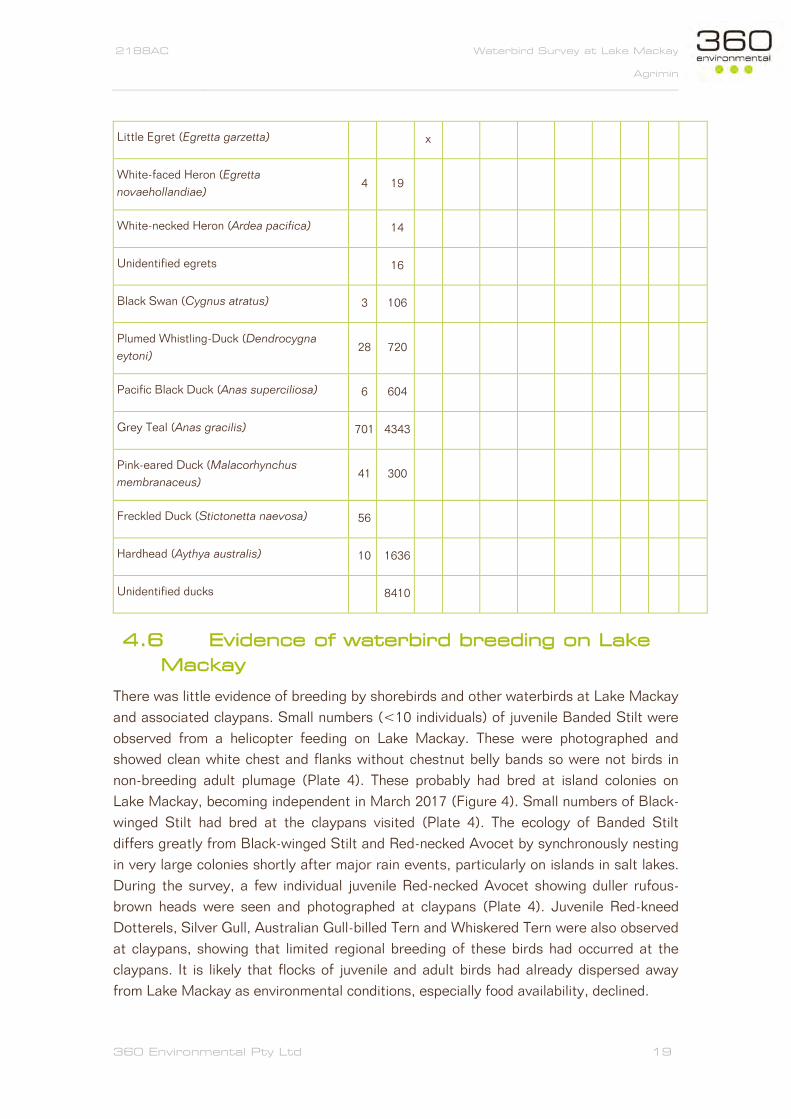
4.6 Evidence of waterbird breeding on Lake
Mackay
There was little evidence of breeding by shorebirds and other waterbirds at Lake Mackay
and associated claypans. Small numbers (<10 individuals) of juvenile Banded Stilt were
observed from a helicopter feeding on Lake Mackay. These were photographed and
showed clean white chest and flanks without chestnut belly bands so were not birds in
non-breeding adult plumage (Plate 4). These probably had bred at island colonies on
Lake Mackay, becoming independent in March 2017 (Figure 4). Small numbers of Black-
winged Stilt had bred at the claypans visited (Plate 4). The ecology of Banded Stilt
differs greatly from Black-winged Stilt and Red-necked Avocet by synchronously nesting
in very large colonies shortly after major rain events, particularly on islands in salt lakes.
During the survey, a few individual juvenile Red-necked Avocet showing duller rufous-
brown heads were seen and photographed at claypans (Plate 4). Juvenile Red-kneed
Dotterels, Silver Gull, Australian Gull-billed Tern and Whiskered Tern were also observed
at claypans, showing that limited regional breeding of these birds had occurred at the
claypans. It is likely that flocks of juvenile and adult birds had already dispersed away
from Lake Mackay as environmental conditions, especially food availability, declined.

2188AC Waterbird Survey at Lake Mackay Waterbird Survey at Lake Mackay
Agrimin
360 Environmental Pty Ltd 20
Figure 4. Breeding phenology of hypothetical colonies of Banded Stilt at Lake Mackay following the December 2016 rain event. Breeding data taken from Marchant and Higgins (1993).

2188AC Waterbird Survey at Lake Mackay Waterbird Survey at Lake Mackay
Agrimin
360 Environmental Pty Ltd 21
5 Discussion
5.1 The boom that went bust – waterbird
abundance in 2017
This waterbird survey of Lake Mackay added a wealth of new information on the
diversity, composition and abundance of waterbird species on the saline lake and nearby
freshwater claypans. The diversity and abundance of waterbirds on Lake Mackay at 114-
117 days after an extreme rainfall event was low. However, waterbirds at nearby
claypans had high diversity (26 species) and were abundant with evidence of breeding
for several species (Figure 5). Five Palearctic shorebird migrants were recorded including
more than 200 Red-necked Stints feeding in shallow water on Lake Mackay. One EPBC
Act listed species, the Australian Painted Snipe, was observed briefly in flight at a small
(13.3 ha) claypan, testament to the capacity of small wetlands to provide habitat for
birds of high conservation significance. A total of seven waterbirds were recorded for the
first time at Lake Mackay and surrounds during this survey: Black-tailed Native-hen,
Hoary-headed Grebe, Red-kneed Dotterel, Red-capped Plover, Black-fronted Dotterel,
Australian Painted Snipe and Freckled Duck. The Australian Painted Snipe record is
notable as it is Australia’s rarest waterbird with a population estimated at only 600-1,700
mature individuals (BirdLife International 2017). It is important to note that there was
only one record of the Australian Painted Snipe and it was approximately 25 km to the
east of one of the proposed infrastructure areas. It was recorded at a claypan and
satellite imagery shows that 1,000s of claypans occur around Lake Mackay.
Observations of Freckled Duck were also noteworthy distributional records, with at least
56 birds in total observed at three claypan sites.
There was secondary evidence of the relatively recent presence of 100-1,000s of
waterbirds at each site visited on the lake, but where only a few individual waterbirds
were actually present in April 2017. The rapid drying of Lake Mackay over hot summer
days with high evaporation presumably leads to the rapid decline of the abundance and
diversity of waterbirds as food availability declines and salinity increases (Kingsford-
Smith et al. 2010). Most waterbirds probably departed Lake Mackay 1-2 months before
the April surveys were carried out.

2188AC Waterbird Survey at Lake Mackay Agrimin
360 Environmental Pty Ltd 22
Figure 5. Comparing abundance of shorebirds, other waterbirds and landbirds on Lake Mackay and nearby claypan wetlands: (A) shorebirds, (B) other waterbirds and (C) landbirds. Birds are ordered from most abundant species on Lake Mackay to least abundant or absent.

2188AC Waterbird Survey at Lake Mackay Agrimin
360 Environmental Pty Ltd 23
Numerous prints of shorebirds and waterbirds were seen on the salt crust at all sites on
Lake Mackay, with large flocks probably departing the area in February or March prior to
the survey. At these sites, waterbirds were in very low numbers (<10 individuals) or
completely absent in April 2017 (see photos below).
5.2 The total number of waterbird species at
Lake Mackay
At least 40 waterbird species have been recorded at Lake Mackay, including 16
shorebird species and 24 other waterbirds (Table 4). In addition, the aerial survey by
Duguid (2005) reported on an additional seven taxa whose identity was unverified. This
might include several additional species, but several unidentified birds were probably
recorded definitively in the current survey. For example, the ‘unidentified shorebirds
smaller than Sharp-tailed Sandpiper’ probably refers to Red-necked Stint which was
observed several times during the present survey both on the lake and adjacent
claypans.
5.3 Boom-bust, rain, flood and evaporation:
comparison to the NT government waterbird
survey of 2001
Surveys by the Northern Territory Government included a fixed wing aerial survey on 6
September 2001 and ground surveys during 3-10 October 2001 (Duguid et al. 2005). A
total of 26 waterbird species were recorded (here excluding Australian Bustard as a
waterbird) including 20 species identified to species-level and six waterbird taxa where it
was impossible to accurately identify to species-level. Of the 20 waterbirds identified,
four were unrecorded in the present survey including three species of ibis and Great
Egret (Table 4). According to coordinates given by Duguid et al. (2005) for individual
waterbird records, all these were recorded on dryland or claypan habitats, rather than on
the saline habitats of Lake Mackay. The present survey was able to confirm the presence

2188AC Waterbird Survey at Lake Mackay Agrimin
360 Environmental Pty Ltd 24
of Whiskered Tern on Lake Mackay, which were observed foraging on saline and claypan
wetlands and breeding in the latter. The migratory White-winged Tern would be expected
to occur at Lake Mackay as an annual migrant in the region especially during September
to March depending on the presence of water. Discriminating Whiskered Tern from the
similarly plumaged White-winged Tern from aerial surveys would be impossible.
There were major differences in the abundance of waterbirds between the two visits. The
2001 aerial survey recorded more than 40,000 waterbirds, whereas in 2017 only 2,591
waterbirds were recorded. Obviously, the type of survey was different, but the major
difference was the extraordinary rainfall during the summer of 2001 where 808.2 mm
was recorded between January to March with three individual weeks receiving more than
100 mm of rain. The December 2016 extreme rainfall event was restricted to a single
week with a smaller total of 551.4 mm recorded from December 2016 up to the present
survey (Figure 6).
Figure 6. Weekly rainfall patterns prior to waterbird surveys on Lake Mackay – the September 2001 and April 2017 survey.

2188AC Waterbird Survey at Lake Mackay Agrimin
360 Environmental Pty Ltd 25
The total amount of rain, the spread and the timing are undoubtedly crucial in causing the
initial flooding, the level (depth) of flooding and in differing rates of evaporation. Early
summer rains such as those in December 2016 allows greater evaporation of any
resulting surface water because there were several months of 35°C plus days. In 2001,
the quantity of rain was greater and occurred over a longer period, with much of it
occurring late in summer, presumably with substantially lower rates of evaporation.
These differences undoubtedly lead to dramatic differences in inundation to Lake
Mackay and surrounding claypans. For example, water depth was measured at 40 cm in
October 2001 and was estimated to have reached a maximum depth of 120 cm (Duguid
et al. 2005) whereas in April 2017 maximum water depth was less than 20 cm, and
mostly only around 1-10 cm. It seems that Lake Mackay is most able to support
waterbird populations over extended periods (4-8 months) when there are a series of
extreme rainfall events, especially towards the end of summer.
There is no data on evaporation available, but 188 days after the rainfall event (5
October 2001) electrical conductivity (EC) was measured by Duguid et al. (2005) at
80,000 µS/cm, while in April 2017 it was substantially higher at 140,000 to 262,000
µS/cm. Seawater has electrical conductivity of approximately 50,000 µS/cm. Electrical
conductivity levels in salt lakes are a major determinant of food webs and the presence
and abundance of waterbirds. For example, Pedler et al. (2014) studied a breeding
colony of Banded Stilt on Lake Eyre when electrical conductivity was 66,000 µS/cm,
however satellite tagged birds had left the colony 7 weeks later when electrical
conductivity reached 127,000 µS/cm.

2188AC Waterbird Survey at Lake Mackay Agrimin
360 Environmental Pty Ltd 26
6 Conclusions
An anticipated boom in primary productivity which would attract and maintain large
numbers of waterbirds on Lake Mackay had largely busted at 114-117 days after a major
rainfall event. Lake Mackay was found to support low numbers of relatively few
waterbird species and no major breeding colonies were recorded. Flocks of 10,000s of
waterbirds may have been present on Lake Mackay up until around February-March
2017, but had moved during summer as water levels and food availability plummeted and
electrical conductivity increased. Many waterbird species obviously use both saline
habitats on Lake Mackay as well as claypans, but specialized species such as Banded
Stilt depend on saline lakes for breeding. This study highlights claypans as habitat
supporting waterbird communities of high conservation significance. Despite their small
areal extent, these held a diverse range and large numbers of waterbirds including EPBC
Act listed species such as the Australian Painted Snipe, Rostratula australis (Australia’s
rarest waterbird) and supported breeding by several waterbird species. Only seven
claypans were surveyed but satellite imagery shows that 1,000s of claypans occur about
Lake Mackay including at least 30 greater than 8 ha.

2188AC Waterbird Survey at Lake Mackay Agrimin
360 Environmental Pty Ltd 27
7 References
Atlas of Living Australia (2017). Atlas of Living Australia website at
http://www.ala.org.au. Accessed 10 April 2017.
Birdata. (2017). Birdata: Distribution Maps. Downloaded April 2017 from
http://birdata.birdlife.org.au/
BirdLife International (2017) Species factsheet: Rostratula australis. Downloaded from
http://www.birdlife.org on 01/05/2017.
Bureau of Meteorology. (2017). Climate data for Wulungurru (Kintore) and Rabbit Flat.
Available at: http://www.bom.gov.au/climate.
Department of Parks and Wildlife (DPaW). (2017). Threatened and Priority Fauna
Database (custom search). Perth, Western Australia.
Desert Wildlife Services (2010). Biological Resources of the Kiwirrkurra Region.
Unpublished report produced for the Ngaanyatjara Council.
Desert Wildlife Services. (2012). Kiwirrkurra Threatened Species Survey 2012.
Unpublished report produced for the Ngaanyatjara Council.
Duguid, A., Burniston, J., Clifford, B., Peavey, C., Albrecht, D., Rasler, J. & McNally, M.
(2005). Wetlands in the arid Northern Territory. A report to the Australian Government
Department of the Environment and Heritage on the inventory and significance of
wetlands in the arid NT. Northern Territory Government Department of Natural
Resources, Environment and the Arts. Alice Springs.
Duguid, A. (2005). Wetlands in the Arid Northern Territory. Volume 2: Information
Collated for Individual Wetlands. A report to the Australian Government Department of
the Environment and Heritage on the inventory and significance of wetlands in the arid
NT. Northern Territory Government Department of Natural Resources, Environment and
the Arts. Alice Springs.
Ecologia. (2017). Level 1 Fauna and single phase Level 2 flora assessment. Ecologia,
Perth.
Halse, S., Pearson, G. B., Hassel, C., Collins, P., Scanlon, M. D. & Minton, C. D. T.
(2005). Mandora Marsh, north-western Australia, an arid-zone wetland maintaining
continental populations of waterbirds. Emu 105: 115–125.
Hawkins, B. (2017) Bush Blitz ‘Kiwirrkurra Indigenous Protected Area’ Personal
communications April-May 2017.
IUCN 2017. The IUCN Red List of Threatened Species. Version 2017-1.
<http://www.iucnredlist.org>. Downloaded on 12 May 2017.
2188AC Waterbird Survey at Lake Mackay Agrimin
360 Environmental Pty Ltd 28
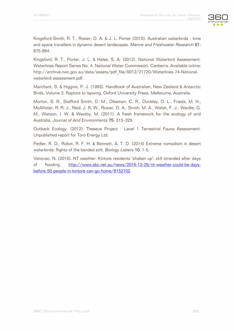
Kingsford-Smith, R. T., Rosier, D. A. & J. L. Porter (2010). Australian waterbirds - time
and space travellers in dynamic desert landscapes. Marine and Freshwater Research 61:
875-884.
Kingsford, R. T., Porter, J. L. & Halse, S. A. (2012). National Waterbird Assessment.
Waterlines Report Series No. 4. National Water Commission, Canberra. Available online:
http://archive.nwc.gov.au/data/assets/pdf_file/0012/21720/Waterlines-74-National-
waterbird-assessment.pdf.
Marchant, S. & Higgins, P. J. (1993). Handbook of Australian, New Zealand & Antarctic
Birds, Volume 2. Raptors to lapwing. Oxford University Press, Melbourne, Australia.
Morton, S. R., Stafford Smith, D. M., Dikeman, C. R., Dunkley, D. L., Frieda, M. H.,
McAllister, R. R. J., Reid, J. R. W., Rosier, D. A., Smith, M. A., Walsh, F. J., Wardle, G.
M., Watson, I. W. & Westby, M. (2011). A fresh framework for the ecology of arid
Australia. Journal of Arid Environments 75: 313–329.
Outback Ecology. (2012). Theseus Project - Level 1 Terrestrial Fauna Assessment.
Unpublished report for Toro Energy Ltd.
Pedler, R. D., Robot, R. F. H. & Bennett, A. T. D. (2014) Extreme nomadism in desert
waterbirds: flights of the banded stilt. Biology Letters 10: 1-5.
Vanovac, N. (2016). NT weather: Kintore residents "shaken up", still stranded after days
of flooding. http://www.abc.net.au/news/2016-12-29/nt-weather-could-be-days-
before-50-people-in-kintore-can-go-home/8152102.

2188AC Waterbird Survey at Lake Mackay Agrimin
360 Environmental Pty Ltd 29
8 Limitations
This report is produced strictly in accordance with the scope of services set out in the
contract or otherwise agreed in accordance with the contract. 360 Environmental makes
no representations or warranties in relation to the nature and quality of soil and water
other than the visual observation and analytical data in this report.
In the preparation of this report, 360 Environmental has relied upon documents,
information, data and analyses (“client’s information”) provided by the client and other
individuals and entities. In most cases where client’s information has been relied upon,
such reliance has been indicated in this report. Unless expressly set out in this report,
360 Environmental has not verified that the client’s information is accurate, exhaustive or
current and the validity and accuracy of any aspect of the report including, or based
upon, any part of the client’s information is contingent upon the accuracy,
exhaustiveness and currency of the client’s information. 360 Environmental shall not be
liable to the client or any other person in connection with any invalid or inaccurate aspect
of this report where that invalidity or inaccuracy arose because the client’s information
was not accurate, exhaustive and current or arose because of any information or
condition that was concealed, withheld, misrepresented, or otherwise not fully disclosed
or available to 360 Environmental.
Aspects of this report, including the opinions, conclusions and recommendations it
contains, are based on the results of the investigation, sampling and testing set out in
the contract and otherwise in accordance with normal practices and standards. The
investigation, sampling and testing are designed to produce results that represent a
reasonable interpretation of the general conditions of the site that is the subject of this
report. However, due to the characteristics of the site, including natural variations in site
conditions, the results of the investigation, sampling and testing may not accurately
represent the actual state of the whole site at all points.
It is important to recognise that site conditions, including the extent and concentration of
contaminants, can change with time. This is particularly relevant if this report, including
the data, opinions, conclusions and recommendations it contains, are to be used a
considerable time after it was prepared. In these circumstances, further investigation of
the site may be necessary.
Subject to the terms of the contract between the Client and 360 Environmental Pty Ltd,
copying, reproducing, disclosing or disseminating parts of this report is prohibited
(except to the extent required by law) unless the report is produced in its entirety
including this page, without the prior written consent of 360 Environmental Pty Ltd.

2188AC Waterbird Survey at Lake Mackay Agrimin
360 Environmental Pty Ltd 30
PLATES

2188AC Waterbird Survey at Lake Mackay Agrimin
360 Environmental Pty Ltd 31
Plate 1. Examples of shorebirds recorded during the survey.
(A) Black-winged Stilt at site C1, (B) Red-necked Avocet at C6, (C) flock of c. 190
Banded Stilt in breeding plumage, roosting near shoreline at L1, (D) Red-capped Plover
at C6, (E) Black-fronted Dotterel at C4, (F) Red-kneed Dotterel atC2, (G) Palearctic
migrant Sharp-tailed Sandpiper at C7, and (H) Palearctic migrant Red-necked Stints,
photographed from helicopter actively feeding on Lake Mackay at L9.

2188AC Waterbird Survey at Lake Mackay Agrimin
360 Environmental Pty Ltd 32
Plate 2. Examples of other waterbirds recorded during the survey.
(A) Freckled Duck at C7, (B) Grey Teal with Red-necked Avocet at C4, (C) Pink-eared
Duck at C7, (D) Hardhead with Grey Teal at C7, (E) Hoary-headed Grebe at C6, (F)
Black-tailed Native-hen at C2, (G) Silver Gull at H26, and (H) Australian Gull-billed Tern
at L2.

2188AC Waterbird Survey at Lake Mackay Agrimin
360 Environmental Pty Ltd 33
Plate 3. Examples of landbirds recorded during the survey:
(A) Spotted Harrier, (B) Australian Bustard, (C) Diamond Dove, (D) Brown Falcon, (E)
male Orange Chat, (F) female Orange Chat, (G) Masked Wood Swallow (H) female
Rufous Whistler, (I) Willy Wagtail, (J) female Red-capped Robin, (K) White-backed
Swallow, (L) Australasian Pipit, and (M) Zebra Finch.

2188AC Waterbird Survey at Lake Mackay Agrimin
360 Environmental Pty Ltd 34
Plate 4. Evidence of recent breeding success in the Lake Mackay area:
(A & B) Juvenile-plumaged Black-winged Stilt at C7, (C) juvenile plumaged Red-necked
Avocet at C7, (D) juvenile Banded Stilt on Lake Mackay at H7, (E) juvenile plumaged
Red-kneed Dotterel at C2, (F) juvenile plumaged Silver Gull at C6, (G) adult Australian
Gull-billed Tern followed by food-begging juvenile bird at left at C6, (H) two juvenile
Whiskered Tern and adult bird at right, at C1, (I) c. 35 mm long eggshell, probably of
Whiskered Tern at C2, (J) recently used nest at rapidly drying claypan, probably
Whiskered Tern at C2.

2188AC Waterbird Survey at Lake Mackay Agrimin
360 Environmental Pty Ltd 35
Plate 5. Aerial view of islands, water channels, large expanses of water and shoreline of Lake Mackay.

2188AC Waterbird Survey at Lake Mackay Agrimin
360 Environmental Pty Ltd 36
Plate 6. Examples of the diversity of bare and well-vegetated claypan wetlands near Lake Mackay.

2188AC Waterbird Survey at Lake Mackay Agrimin
360 Environmental Pty Ltd 37
APPENDIX A Definitions of Threatened Fauna Species Categories

2188AC Waterbird Survey at Lake Mackay Agrimin
360 Environmental Pty Ltd 38
Western Australian Threatened Fauna Categories Wildlife Conservation Act 1950 (WA)
CATEGORY CODE DESCRIPTION
Schedule 1 S1 Rare or likely to become extinct as critically endangered
fauna.
Schedule 2 S2 Fauna that is rare or is likely to become extinct as
endangered fauna.
Schedule 3 S3 Fauna that is rare or is likely to become extinct as vulnerable
fauna.
Schedule 4 S4 Fauna presumed to be extinct.
Schedule 5 S5 Migratory birds protected under an international agreement.
Schedule 6 S6 Fauna that is of special conservation need as conservation
dependent fauna.
Schedule 7 S7 Other specially protected fauna.
Department of Parks and Wildlife Fauna Priority Codes
CATEGORY CODE DESCRIPTION
Priority 1 P1 Taxa with few, poorly known populations on threatened lands.
Priority 2 P2 Taxa with few, poorly known populations on conservation
lands.
Priority 3 P3 Taxa with several, poorly known populations, some on
conservation lands.
Priority 4 P4
Taxa in need of monitoring: not currently threatened or in
need of special protection, but could become so.
Usually represented on conservation lands.
Priority 5 P5
Taxa in need of monitoring: not considered threatened, but
the subject of a specific conservation program, the cessation
of which would result in the species becoming threatened
within five years.
Categories of Threatened Fauna Species under the EPBC Act
CONSERVATION
CODE DESCRIPTION
Ex
Extinct
Taxa which at a particular time if, at the time, there is no reasonable doubt
that the last member of the species has died.
Exec Extinct in the Wild
Taxa which is known only to survive in cultivation, in captivity or as a
naturalised population well outside its past range; or it has not been
recorded in its known and/or expected habitat, at appropriate seasons,
anywhere in its past range, despite exhaustive surveys over a time frame
appropriate to its life cycle and form.

2188AC Waterbird Survey at Lake Mackay Agrimin
360 Environmental Pty Ltd 39
CE Critically Endangered
Taxa which at a particular time, it is facing an extremely high risk of
extinction in the wild in the immediate future, as determined in accordance
with the prescribed criteria.
E Endangered
Taxa which is not critically endangered and it is facing a very high risk of
extinction in the wild in the medium-term future, as determined in
accordance with the prescribed criteria.
V Vulnerable
Taxa which is not critically endangered or endangered and is facing a high
risk of extinction in the wild in the medium-term future, as determined in
accordance with the prescribed criteria.
CD Conservation Dependent
Taxa which at a particular time if, at that time, the species is the focus of a
specific conservation program, the cessation of which would result in the
species becoming vulnerable, endangered or critically endangered within a
period of 5 years.
MI Migratory
Taxa that migrate to Australia and its external territories, or pass through
or over Australian waters during their annual migrations, that are included
in an international agreement approved by the Minister for the
Environment, Heritage and the Arts and that have been placed on the
national List of Migratory Species under the provisions of the EPBC Act.
At present there are four such agreements:
the Bonn Convention
the China-Australia Migratory Bird Agreement (CAMBA)
the Japan-Australia Migratory Bird Agreement (JAMBA)
the Republic of Korea-Australia Migratory Bird Agreement
(ROKAMBA)
Ma Marine
Taxa protected in a Commonwealth Marine Protected Area by virtue of
section 248 of the EPBC Act. These taxa include certain seals, crocodiles,
turtles and birds, as well as various marine fish.
Commonwealth marine areas are matters of national environmental
significance under the EPBC Act.
An action will require approval if the:
action is taken in a Commonwealth marine area and the action has,
will have, or is likely to have a significant impact on the
environment, or
action is taken outside a Commonwealth marine area and the
action has, will have, or is likely to have a significant impact on the
environment in a Commonwealth marine area1

2188AC Waterbird Survey at Lake Mackay Agrimin
360 Environmental Pty Ltd 40
The Commonwealth marine area is any part of the sea, including the
waters, seabed, and airspace, within Australia's exclusive economic zone
and/or over the continental shelf of Australia, that is not State or Northern
Territory waters.
The Commonwealth marine area stretches from 3 to 200 nautical miles
(approximately 5-370 km) from the coast. Marine protected areas are
marine areas which are recognised to have high conservation value.
Source: Environment Protection and Biodiversity Conservation Act 1999

2188AC Waterbird Survey at Lake Mackay Agrimin
360 Environmental Pty Ltd 41
APPENDIX B Summary characteristics of the 45 sites surveyed by
helicopter on Lake Mackay and nearby claypans, including
location, date, and whether birds were present at site or
absent. Refer to ground survey sites in Table 1.

2188AC Waterbird Survey at Lake Mackay Agrimin
360 Environmental Pty Ltd 42
SITE
CODE
SIT
E F
UL
L
NA
ME
ZO
NE
EA
STIN
G
NO
RTH
ING
DA
TE
TIM
E
BIR
DS
PR
ES
EN
T
BIR
DS
AB
SE
NT
H6 Lake Mackay, Heli6,
claypan 52K 492953 7495775 14-Apr-17 15:10PM x
H7 Lake Mackay, Heli7,
claypan 52K 491792 7494368 14-Apr-17 15:11PM x
H8 Lake Mackay, Heli8,
claypan 52K 490807 7494395 14-Apr-17 14:20PM x
H24 Lake Mackay, Heli24,
claypan 52K 449634 7496858 16-Apr-17 10:50AM x
H30 Lake Mackay, Heli30,
claypan 52K 441053 7494299 15-Apr-17 17:26PM x
H26 Lake Mackay, Heli26,
claypan 52K 457535 7492729 16-Apr-17 10:54AM x
H15 Lake Mackay, Heli15 52K 491368 7500281 16-Apr-17 9:53AM x
H16 Lake Mackay, Heli16 52K 492411 7499266 16-Apr-17 9:57AM x
H17 Lake Mackay, Heli17 52K 489465 7495961 16-Apr-17 10:04AM x
H18 Lake Mackay, Heli18 52K 489225 7494882 16-Apr-17 10:05AM x
H19 Lake Mackay, Heli19 52K 489897 7493222 16-Apr-17 10:07AM x
H20 Lake Mackay, Heli20 52K 490019 7492574 16-Apr-17 10:08AM x
H21 Lake Mackay, Heli21 52K 486718 7491260 16-Apr-17 x
H22 Lake Mackay, Heli22 52K 483125 7492146 16-Apr-17 x
H25 Lake Mackay, Heli25 52K 454942 7494200 16-Apr-17 10:53AM x
H29 Lake Mackay, Heli29 52K 445227 7491788 15-Apr-17 17:22PM x
H31 Lake Mackay, Heli31 52K 437130 7493845 15-Apr-17 17:27PM x
H34 Lake Mackay, Heli34 52K 461057 7490964 16-Apr-17 10:55AM x

2188AC Waterbird Survey at Lake Mackay Agrimin
360 Environmental Pty Ltd 43
H35 Lake Mackay, Heli35 52K 482660 7492208 16-Apr-17 11:15AM x
H36 Lake Mackay, Heli36 52K 485846 7494445 16-Apr-17 x
H37 Lake Mackay, Heli37 52K 488913 7497488 16-Apr-17 x
H39 Lake Mackay, Heli39 52K 438664 7493257 17-Apr-17 7:44AM x
H48 Heli48 52K 483838 7512597 16-Apr-17 11:28AM x
H9 Heli9 52K 485806 7491949 15-Apr-17 x
H10 Heli10 52K 483170 7492594 15-Apr-17 x
H11 Heli11 52K 480983 7492596 15-Apr-17 x
H12 Heli12 52K 473246 7504289 15-Apr-17 x
H13 Heli13 52K 474430 7506850 15-Apr-17 x
H14 Heli14 52K 480300 7520184 15-Apr-17 x
H23 Heli23 52K 480607 7492557 16-Apr-17 x
H27 Heli27 52K 472818 7510650 15-Apr-17 17:10PM x
H32 Heli32 52K 482334 7500671 16-Apr-17 x
H33 Heli33 52K 479426 7500554 16-Apr-17 x
H38 Heli38 52K 488471 7506214 16-Apr-17 x
H40 Heli40 52K 485875 7509610 16-Apr-17 x
H41 Heli41 52K 480118 7512149 16-Apr-17 x
H42 Heli42 52K 479208 7514707 16-Apr-17 x
H43 Heli43 52K 476202 7514610 16-Apr-17 x
H44 Heli44 52K 478648 7511185 16-Apr-17 x
H45 Heli45 52K 476784 7513438 16-Apr-17 x
H46 Heli46 52K 480664 7503573 16-Apr-17 x

2188AC Waterbird Survey at Lake Mackay Agrimin
360 Environmental Pty Ltd 44
H47 Heli47 52K 478338 7504820 16-Apr-17 x
H49 Heli49 52K 476392 7507204 16-Apr-17 x
H50 Heli50 52K 473794 7510072 16-Apr-17 x
H51 Heli51 52K 469548 7514612 16-Apr-17 x

2188AC Waterbird Survey at Lake Mackay Agrimin
360 Environmental Pty Ltd 45
APPENDIX C
Photographic documentation of ground survey sites.
Refer to Table 1 for further site details

2188AC Waterbird Survey at Lake Mackay Agrimin
360 Environmental Pty Ltd 46
Lake Mackay 1 (L1) - aerial view on approach showing proximity of water to a small
island and view of shoreline of Lake Mackay.
Lake Mackay 1 (L1) - view of shoreline of Lake Mackay.

2188AC Waterbird Survey at Lake Mackay Agrimin
360 Environmental Pty Ltd 47
Lake Mackay 2 (L2) - small island view over Lake Mackay shoreline.
Lake Mackay 2 (L2) - view of shoreline and shallow water channel between islands in
lake.

2188AC Waterbird Survey at Lake Mackay Agrimin
360 Environmental Pty Ltd 48
Lake Mackay 5 (L5) - aerial view over well-watered extreme south-east corner of Lake
Mackay.
Site: Lake Mackay 6 (L6).

2188AC Waterbird Survey at Lake Mackay Agrimin
360 Environmental Pty Ltd 49
Site: Lake Mackay 7 (L7) - deep mud at this south-east Lake Mackay site meant that
aquatic sampling could not be done.
Site: Lake Mackay 8 (L8) - aerial view on landing, water sampled on left side of island at
narrow channel.

2188AC Waterbird Survey at Lake Mackay Agrimin
360 Environmental Pty Ltd 50
Site: Claypan1 (C1) - view over well vegetated freshwater basin wetland.
Site: Claypan2 (C1) - view over well vegetated freshwater basin wetland.

2188AC Waterbird Survey at Lake Mackay Agrimin
360 Environmental Pty Ltd 51
Site: Claypan3 (C3) - view over well vegetated freshwater basin wetland.
Site: Claypan4 (C4) - view over sparsely vegetated and turbid freshwater basin wetland.

2188AC Waterbird Survey at Lake Mackay Agrimin
360 Environmental Pty Ltd 52
Site: Claypan5 (C5) - view over rapidly drying and small claypan, devoid of waterbirds.
Site: Claypan6 (C6) - large deep open water claypan with 100s of ducks and other
waterbirds.

2188AC Waterbird Survey at Lake Mackay Agrimin
360 Environmental Pty Ltd 53
Site: Claypan7 (C7) - large deep, well-vegetated, open water claypan with 100s of ducks
and other waterbirds.
Site: Claypan7 (C7) - large deep, well-vegetated, open water claypan with 100s of ducks
and other waterbirds.

2188AC Waterbird Survey at Lake Mackay Agrimin
360 Environmental Pty Ltd 54
APPENDIX D
The 191 georeferenced bird by site records. Refer to
Table 2 and Appendix B for further site details.

2188AC Waterbird Survey at Lake Mackay Agrimin
360 Environmental Pty Ltd 55
SITE
CODE DATE TIME COMMON NAME SCIENTIFIC NAME COUNT
C7 04-17-2017 11:25 AM Australasian Bushlark Mirafra javanica 3
C1 04-15-2017 12:40 PM Australasian Pipit Anthus novaeseelandiae 2
C2 04-15-2017 1:30 PM Australasian Pipit Anthus novaeseelandiae 14
C3 04-16-2017 3:00 PM Australasian Pipit Anthus novaeseelandiae 2
C6 04-17-2017 12:35 PM Australasian Pipit Anthus novaeseelandiae 2
C7 04-17-2017 11:25 AM Australasian Pipit Anthus novaeseelandiae 2
L3 04-15-2017 8:00 AM Australasian Pipit Anthus novaeseelandiae 3
H25 04-16-2017 10:53 AM Australian Bustard Ardeotis australis 1
H31 04-15-2017 5:27 PM Australian Bustard Ardeotis australis 1
H34 04-16-2017 10:55 AM Australian Bustard Ardeotis australis 1
H39 04-17-2017 7:44 AM Australian Bustard Ardeotis australis 1
L3 04-15-2017 8:00 AM Australian Bustard Ardeotis australis 1
C2 04-15-2017 1:30 PM
Australian Painted
Snipe Rostratula australis 1
C4 04-17-2017 8:15 AM Banded Lapwing Vanellus tricolor 2
C3 04-16-2017 3:00 PM Banded Stilt Cladorhynchus leucocephalus 1
C7 04-17-2017 11:25 AM Banded Stilt Cladorhynchus leucocephalus 1
H16 04-16-2017 9:57 AM Banded Stilt Cladorhynchus leucocephalus 3
H18 04-16-2017 10:05 AM Banded Stilt Cladorhynchus leucocephalus 1
H20 04-16-2017 10:08 AM Banded Stilt Cladorhynchus leucocephalus 1
H6 04-14-2017 3:10 PM Banded Stilt Cladorhynchus leucocephalus 20
L1 04-14-2017 12:05 PM Banded Stilt Cladorhynchus leucocephalus 190

2188AC Waterbird Survey at Lake Mackay Agrimin
360 Environmental Pty Ltd 56
L2 04-14-2017 3:30 PM Banded Stilt Cladorhynchus leucocephalus 35
L9 04-16-2017 8:36 AM Banded Stilt Cladorhynchus leucocephalus 5
H30 04-17-2017 5:22 PM Black Swan Cygnus atratus 1
H8 04-14-2017 2:20 PM Black Swan Cygnus atratus 2
L10 04-15-2017 4:20 PM
Black-faced Cuckoo
shrike Coracina novaehollandiae 2
C4 04-17-2017 8:15 AM Black-fronted Dotterel Elseyornis melanops 1
C2 04-15-2017 1:30 PM Black-tailed Native-hen Tribonyx ventralis 18
C1 04-15-2017 12:40 PM Black-winged Stilt Himantopus leucocephalus 8
C2 04-15-2017 1:30 PM Black-winged Stilt Himantopus leucocephalus 13
C3 04-16-2017 3:00 PM Black-winged Stilt Himantopus leucocephalus 10
C7 04-17-2017 11:25 AM Black-winged Stilt Himantopus leucocephalus 80
H24 04-16-2017 10:50 AM Black-winged Stilt Himantopus leucocephalus 20
C2 04-15-2017 1:30 PM Brown Falcon Falco berigora 1
C3 04-16-2017 3:00 PM Brown Falcon Falco berigora 1
C1 04-15-2017 12:40 PM Budgerigar Melopsittacus undulatus 10
C3 04-16-2017 3:00 PM Budgerigar Melopsittacus undulatus 1
C4 04-17-2017 8:15 AM Budgerigar Melopsittacus undulatus 20
C5 04-17-2017 10:40 AM Budgerigar Melopsittacus undulatus 10
L4 04-15-2017 10:30 AM Budgerigar Melopsittacus undulatus 121
L9 04-16-2017 8:36 AM Budgerigar Melopsittacus undulatus 10
C2 04-15-2017 1:30 PM Cockatiel Nymphicus hollandicus 12
C7 04-17-2017 11:25 AM Common Greenshank Tringa nebularia 4
C4 04-17-2017 8:15 AM Crested Pigeon Ocyphaps lophotes 1

2188AC Waterbird Survey at Lake Mackay Agrimin
360 Environmental Pty Ltd 57
C2 04-15-2017 1:30 PM Diamond Dove Geopelia cuneata 1
C3 04-16-2017 3:00 PM Diamond Dove Geopelia cuneata 2
C7 04-17-2017 11:25 AM Eurasian Coot Fulica atra 30
C3 04-16-2017 3:00 PM Freckled Duck Stictonetta naevosa 6
C6 04-17-2017 12:35 PM Freckled Duck Stictonetta naevosa 44
C7 04-17-2017 11:25 AM Freckled Duck Stictonetta naevosa 6
C1 04-15-2017 12:40 PM Grey Teal Anas gracilis 42
C2 04-15-2017 1:30 PM Grey Teal Anas gracilis 4
C3 04-16-2017 3:00 PM Grey Teal Anas gracilis 70
C4 04-17-2017 8:15 AM Grey Teal Anas gracilis 77
C6 04-17-2017 12:35 PM Grey Teal Anas gracilis 128
C7 04-17-2017 11:25 AM Grey Teal Anas gracilis 120
H26 04-16-2017 10:54 AM Grey Teal Anas gracilis 120
H29 04-15-2017 5:22 PM Grey Teal Anas gracilis 40
H30 04-15-2017 5:26 PM Grey Teal Anas gracilis 100
C6 04-17-2017 12:35 PM
Australian Gull-billed
Tern Gelochelidon macrotarsa 11
C7 04-17-2017 11:25 AM
Australian Gull-billed
Tern Gelochelidon macrotarsa 18
L1 04-14-2017 12:05 PM
Australian Gull-billed
Tern Gelochelidon macrotarsa 3
L2 04-14-2017 3:30 PM
Australian Gull-billed
Tern Gelochelidon macrotarsa 1
L7 04-14-2017 2:30 PM
Australian Gull-billed
Tern Gelochelidon macrotarsa 1
L9 04-16-2017 8:36 AM
Australian Gull-billed
Tern Gelochelidon macrotarsa 5

2188AC Waterbird Survey at Lake Mackay Agrimin
360 Environmental Pty Ltd 58
C1 04-15-2017 12:40 PM Hardhead Aythya australis 4
C3 04-16-2017 3:00 PM Hardhead Aythya australis 4
C7 04-17-2017 11:25 AM Hardhead Aythya australis 2
C1 04-15-2017 12:40 PM Hoary-headed Grebe Poliocephalus poliocephalus 100
C2 04-15-2017 1:30 PM Hoary-headed Grebe Poliocephalus poliocephalus 40
C3 04-16-2017 3:00 PM Hoary-headed Grebe Poliocephalus poliocephalus 15
C6 04-17-2017 12:35 PM Hoary-headed Grebe Poliocephalus poliocephalus 20
C7 04-17-2017 11:25 AM Hoary-headed Grebe Poliocephalus poliocephalus 100
H26 04-16-2017 10:54 AM Hoary-headed Grebe Poliocephalus poliocephalus 40
H29 04-15-2017 5:22 PM Hoary-headed Grebe Poliocephalus poliocephalus 20
C1 04-15-2017 12:40 PM Little Buttonquail Turnix velox 1
C6 04-17-2017 12:35 PM Little Buttonquail Turnix velox 4
C7 04-17-2017 11:25 AM Little Buttonquail Turnix velox 1
C4 04-17-2017 8:15 AM Little Crow Corvus bennetti 1
C3 04-16-2017 3:00 PM Magpie-lark Grallina cyanoleuca 1
C5 04-17-2017 10:40 AM Masked Wood swallow Artamus personatus 2
C3 04-16-2017 3:00 PM Nankeen Kestrel Falco cenchroides 1
H39 04-16-2017 11:28 AM Nankeen Kestrel Falco cenchroides 1
L10 04-15-2017 4:20 PM Nankeen Kestrel Falco cenchroides 1
C4 04-17-2017 8:15 AM Orange Chat Epthianura aurifrons 1
C6 04-17-2017 12:35 PM Orange Chat Epthianura aurifrons 2
C7 04-17-2017 11:25 AM Orange Chat Epthianura aurifrons 42
C6 04-17-2017 12:35 PM Pacific Black Duck Anas superciliosa 6

2188AC Waterbird Survey at Lake Mackay Agrimin
360 Environmental Pty Ltd 59
C3 04-16-2017 3:00 PM Pink-eared Duck Malacorhynchus membranaceus 8
C4 04-17-2017 8:15 AM Pink-eared Duck Malacorhynchus membranaceus 2
C6 04-17-2017 12:35 PM Pink-eared Duck Malacorhynchus membranaceus 8
C7 04-17-2017 11:25 AM Pink-eared Duck Malacorhynchus membranaceus 23
C3 04-16-2017 3:00 PM Plumed Whistling-Duck Dendrocygna eytoni 11
C6 04-17-2017 12:35 PM Plumed Whistling-Duck Dendrocygna eytoni 17
C6 04-17-2017 12:35 PM Red-capped Plover Charadrius ruficapillus 1
C7 04-17-2017 11:25 AM Red-capped Plover Charadrius ruficapillus 23
L1 04-14-2017 12:05 PM Red-capped Plover Charadrius ruficapillus 2
L2 04-14-2017 3:30 PM Red-capped Plover Charadrius ruficapillus 3
L6 04-14-2017 9:40 AM Red-capped Plover Charadrius ruficapillus 20
L9 04-16-2017 8:36 AM Red-capped Plover Charadrius ruficapillus 22
C2 04-15-2017 1:30 PM Red-capped Robin Petroica goodenovii 2
C4 04-17-2017 8:15 AM Red-capped Robin Petroica goodenovii 1
L4 04-15-2017 10:30 AM Red-capped Robin Petroica goodenovii 1
C2 04-15-2017 1:30 PM Red-kneed Dotterel Erythrogonys cinctus 8
C3 04-16-2017 3:00 PM Red-kneed Dotterel Erythrogonys cinctus 3
C7 04-17-2017 11:25 AM Red-kneed Dotterel Erythrogonys cinctus 23
C3 04-16-2017 3:00 PM Red-necked Avocet Recurvirostra novaehollandiae 26
C4 04-17-2017 8:15 AM Red-necked Avocet Recurvirostra novaehollandiae 33
C7 04-17-2017 11:25 AM Red-necked Avocet Recurvirostra novaehollandiae 200
H26 04-16-2017 10:54 AM Red-necked Avocet Recurvirostra novaehollandiae 100
H30 04-17-2017 5:22 PM Red-necked Avocet Recurvirostra novaehollandiae 4

2188AC Waterbird Survey at Lake Mackay Agrimin
360 Environmental Pty Ltd 60
C7 04-17-2017 11:25 AM Red-necked Stint Calidris ruficollis 250
H15 04-16-2017 9:53 AM Red-necked Stint Calidris ruficollis 2
H18 04-16-2017 10:05 AM Red-necked Stint Calidris ruficollis 20
H21 04-16-2017 10:11 AM Red-necked Stint Calidris ruficollis 20
L2 04-14-2017 3:30 PM Red-necked Stint Calidris ruficollis 10
L9 04-16-2017 8:36 AM Red-necked Stint Calidris ruficollis 200
L3 04-15-2017 8:00 AM Rufous Songlark Megalurus mathewsi 3
L4 04-15-2017 10:30 AM Rufous Whistler Pachycephala rufiventris 2
C1 04-15-2017 12:40 PM Sharp-tailed Sandpiper Calidris acuminata 8
C2 04-15-2017 1:30 PM Sharp-tailed Sandpiper Calidris acuminata 20
C7 04-17-2017 11:25 AM Sharp-tailed Sandpiper Calidris acuminata 3
L9 04-16-2017 8:36 AM Sharp-tailed Sandpiper Calidris acuminata 6
C1 04-15-2017 12:40 PM Silver Gull Chroicocephalus novaehollandiae 19
C2 04-15-2017 1:30 PM Silver Gull Chroicocephalus novaehollandiae 4
C3 04-16-2017 3:00 PM Silver Gull Chroicocephalus novaehollandiae 151
C7 04-17-2017 11:25 AM Silver Gull Chroicocephalus novaehollandiae 2
H18 04-16-2017 10:05 AM Silver Gull Chroicocephalus novaehollandiae 3
H21 04-16-2017 10:11 AM Silver Gull Chroicocephalus novaehollandiae 25
H22 04-16-2017 10:12 AM Silver Gull Chroicocephalus novaehollandiae 2
H24 04-16-2017 10:50 AM Silver Gull Chroicocephalus novaehollandiae 4
H26 04-16-2017 10:54 AM Silver Gull Chroicocephalus novaehollandiae 120
H35 04-16-2017 11:15 AM Silver Gull Chroicocephalus novaehollandiae 4
H36 04-16-2017 11:20 AM Silver Gull Chroicocephalus novaehollandiae 4

2188AC Waterbird Survey at Lake Mackay Agrimin
360 Environmental Pty Ltd 61
H37 04-16-2017 11:22 AM Silver Gull Chroicocephalus novaehollandiae 3
H6 04-14-2017 3:10 PM Silver Gull Chroicocephalus novaehollandiae 2
H7 04-14-2017 3:11 PM Silver Gull Chroicocephalus novaehollandiae 60
L1 04-14-2017 12:05 PM Silver Gull Chroicocephalus novaehollandiae 4
L5 04-16-2017 1:05 PM Silver Gull Chroicocephalus novaehollandiae 1
L6 04-14-2017 9:40 AM Silver Gull Chroicocephalus novaehollandiae 5
L7 04-14-2017 2:30 PM Silver Gull Chroicocephalus novaehollandiae 64
L8 04-16-2017 12:00 PM Silver Gull Chroicocephalus novaehollandiae 1
L9 04-16-2017 8:36 AM Silver Gull Chroicocephalus novaehollandiae 7
L10 04-15-2017 4:20 PM Singing Honeyeater Gavicalis virescens 6
L9 04-16-2017 8:36 AM Singing Honeyeater Gavicalis virescens 3
C2 04-15-2017 1:30 PM Spotted Harrier Circus assimilis 1
C3 04-16-2017 3:00 PM Spotted Harrier Circus assimilis 1
C5 04-17-2017 10:40 AM Spotted Harrier Circus assimilis 1
L3 04-15-2017 8:00 AM Spotted Harrier Circus assimilis 1
C7 04-17-2017 11:25 AM Square-tailed Kite Lophoictinia isura 1
C2 04-15-2017 1:30 PM Tree Martin Petrochelidon nigricans 8
C2 04-15-2017 1:30 PM Variegated Fairywren Malurus lamberti 8
C6 04-17-2017 12:35 PM Variegated Fairywren Malurus lamberti 12
C1 04-15-2017 12:40 PM Whiskered Tern Chlidonias hybrida 74
C4 04-17-2017 8:15 AM Whiskered Tern Chlidonias hybrida 1
C7 04-17-2017 11:25 AM Whiskered Tern Chlidonias hybrida 4
H17 04-16-2017 10:04 AM Whiskered Tern Chlidonias hybrida 2

2188AC Waterbird Survey at Lake Mackay Agrimin
360 Environmental Pty Ltd 62
H19 04-16-2017 10:07 AM Whiskered Tern Chlidonias hybrida 5
H30 04-15-2017 5:26 PM Whiskered Tern Chlidonias hybrida 20
H36 04-16-2017 11:20 AM Whiskered Tern Chlidonias hybrida 1
L1 04-14-2017 12:05 PM Whiskered Tern Chlidonias hybrida 1
C1 04-15-2017 12:40 PM Whistling Kite Haliastur sphenurus 1
C2 04-15-2017 1:30 PM Whistling Kite Haliastur sphenurus 6
C7 04-17-2017 11:25 AM Whistling Kite Haliastur sphenurus 2
L3 04-15-2017 8:00 AM White-backed Swallow Cheramoeca leucosterna 7
L6 04-14-2017 9:40 AM White-backed Swallow Cheramoeca leucosterna 12
L8 04-16-2017 12:00 PM White-backed Swallow Cheramoeca leucosterna 3
C1 04-15-2017 12:40 PM White-faced Heron Egretta novaehollandiae 1
C6 04-17-2017 12:35 PM White-faced Heron Egretta novaehollandiae 2
C7 04-17-2017 11:25 AM White-faced Heron Egretta novaehollandiae 1
C1 04-15-2017 12:40 PM Willie Wagtail Rhipidura leucophrys 6
C2 04-15-2017 1:30 PM Willie Wagtail Rhipidura leucophrys 8
C3 04-16-2017 3:00 PM Willie Wagtail Rhipidura leucophrys 4
C4 04-17-2017 8:15 AM Willie Wagtail Rhipidura leucophrys 1
C5 04-17-2017 10:40 AM Willie Wagtail Rhipidura leucophrys 1
C6 04-17-2017 12:35 PM Willie Wagtail Rhipidura leucophrys 2
C7 04-17-2017 11:25 AM Willie Wagtail Rhipidura leucophrys 12
L10 04-15-2017 4:20 PM Willie Wagtail Rhipidura leucophrys 1
L3 04-15-2017 8:00 AM Willie Wagtail Rhipidura leucophrys 2
L4 04-15-2017 10:30 AM Willie Wagtail Rhipidura leucophrys 3

2188AC Waterbird Survey at Lake Mackay Agrimin
360 Environmental Pty Ltd 63
L9 04-16-2017 8:36 AM Willie Wagtail Rhipidura leucophrys 1
C1 04-15-2017 12:40 PM Zebra Finch Taeniopygia guttata castanotis 10
C2 04-15-2017 1:30 PM Zebra Finch Taeniopygia guttata castanotis 45
C3 04-16-2017 3:00 PM Zebra Finch Taeniopygia guttata castanotis 12
C4 04-17-2017 8:15 AM Zebra Finch Taeniopygia guttata castanotis 10
C5 04-17-2017 10:40 AM Zebra Finch Taeniopygia guttata castanotis 10
C7 04-17-2017 11:25 AM Zebra Finch Taeniopygia guttata castanotis 10
L3 04-15-2017 8:00 AM Zebra Finch Taeniopygia guttata castanotis 2
L4 04-15-2017 10:30 AM Zebra Finch Taeniopygia guttata castanotis 80
L6 04-14-2017 9:40 AM Zebra Finch Taeniopygia guttata castanotis 2
L9 04-16-2017 8:36 AM Zebra Finch Taeniopygia guttata castanotis 30