weather basics - united states naval academy...lutgens and tarbuck, 8th edition, 2001. resulting in...
TRANSCRIPT

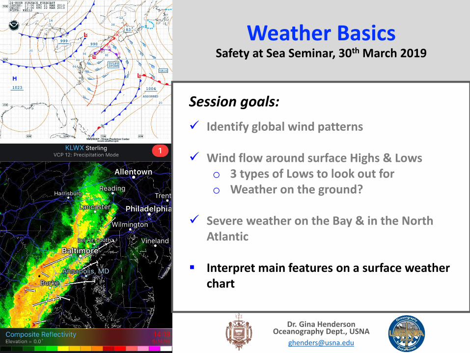
Weather BasicsSafety at Sea Seminar, 30th March 2019
Dr. Gina HendersonOceanography Dept., USNA
Session goals:
Identify global wind patterns
Wind flow around surface Highs & Lowso 3 types of Lows to look out foro Weather on the ground?
Severe weather on the Bay & in the North Atlantic
Interpret main features on a surface weather chart

Wind horizontal movement of air
‘Naming’ windo From source direction
Let’s take a step back to remember some basics:
Figures courtesy of Meteorology today, 11th edition, Ahrens, 1th edition, 2016

‘Naming’ windo From source direction
Measuring wind speedoKnots
oMPH
oBeaufort Scale
Let’s take a step back to remember some basics:
Image source: http://www.crh.noaa.gov/Image/iwx/publications/Beaufort_Wind_Chart.pdf
What makes air move creating wind?

Let’s take a step back to remember some basics:What makes wind blow?
1. Pressure gradient force is directed from H to L

Let’s take a step back to remember some basics:What makes wind blow?
1. Pressure gradient force is directed from H to L
Increased pressure gradient
increased wind speed

Let’s take a step back to remember some basics:What makes wind blow?
1. Pressure gradient force is directed from H to L
2. Coriolis force, due to Earth’s rotation, deflects air to the right of its path of motion

Let’s take a step back to remember some basics:What makes wind blow?
1. Pressure gradient force is directed from H to L
2. Coriolis force, due to Earth’s rotation, deflects air to the right of its path of motion
Pressure gradient + Coriolis = wind direction around a surface High & Low pressure
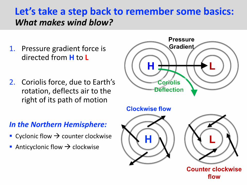
Let’s take a step back to remember some basics:What makes wind blow?
1. Pressure gradient force is directed from H to L
2. Coriolis force, due to Earth’s rotation, deflects air to the right of its path of motion
In the Northern Hemisphere:
Cyclonic flow counter clockwise
Anticyclonic flow clockwise

Resulting in wind patterns you have all heard of:
Trade Winds
Westerlies
Horse Latitudes
Doldrums
This even translates to global wind patterns……
H
L
LH
Figure courtesy of The Atmosphere, 8th edition, Lutgens and Tarbuck, 8th edition, 2001

Resulting in wind patterns you have all heard of:
Trade Winds
Westerlies
Horse Latitudes
Doldrums
This even translates to global wind patterns……
H
L
LH
Figure courtesy of The Atmosphere, 8th edition, Lutgens and Tarbuck, 8th edition, 2001
Apply pressure gradient & coriolis NE trades!

Let’s take a look at some Highs & Lows on a surface weather chart…..
Q High or low pressure in comparison to what? mean sea level pressure: 1013 mb
Q What is the direction of wind flow around this Low?
High pressure systems: clear, settled weather Wind strength dependent
on pressure gradient

3 types of Low pressure systems:
1. Mid-latitude Lows:
most common between 30-60 N/S move (in general) from W E associated with fronts
o boundary between air mass of different characteristics
Types of fronts include: Cold fronts Warm fronts Stationary fronts Occluded fronts

3 types of Low pressure systems: 1. Mid-latitude Low – cold front passage
Figure courtesy of Meteorology today, 11th edition, Ahrens, 1th edition, 2016
X

3 types of Low pressure systems: 1. Mid-latitude Low – warm front passage
X
Figure courtesy of The Atmosphere, 8th edition, Lutgens and Tarbuck, 8th edition, 2001

3 types of Low pressure systems: 1. Mid-latitude Low – stationary front
Cold air Warm air
Clouds will vary
Precipitation intensity will vary

3 types of Low pressure systems: 1. Mid-latitude Low – occluded front
Figure courtesy of Meteorology today, 11th edition, Ahrens, 1th edition, 2016

3 types of Low pressure systems: 2. Cut-off Lows
"Cut-off low, weatherman's woe” move very slowly & can drift for many days
Challenging to forecast Unsettled weather in east and northward quadrants of the low
Image source: https://www.weather.gov/jetstream/basic, accessed 03/29/19
Figure courtesy of Meteorology today, 11th edition, Ahrens, 1th edition, 2016

3 types of Low pressure systems: 3. Tropical Lows – cyclones/hurricanes
Storms fueled by warm tropical waters
Hurricanes are really tropical cyclones
Atlantic hurricane season is June 1st – Nov 30th
Tropical storm: sustained winds 34-63 knts Hurricane: sustained winds > 64 knts

3 types of Low pressure systems: 3. Tropical Lows – cyclones/hurricanes
Storms fueled by warm tropical waters
Hurricanes are really tropical cyclones
Atlantic hurricane season is June 1st – Nov 30th
Tropical storm: sustained winds 34-63 knts Hurricane: sustained winds > 64 knts

3 types of Low pressure systems: 3. Tropical Lows – cyclones/hurricanes
Storms fueled by warm tropical waters
Hurricanes are really tropical cyclones
Atlantic hurricane season is June 1st – Nov 30th
Tropical storm: sustained winds 34-63 knts Hurricane: sustained winds > 64 knts
Maximum wind speeds found in front right quadrant of tropical cycloneo sustained wind + forward movement
of storm
Figure courtesy of Meteorology today, 11th edition, Ahrens, 1th edition, 2016

Weather BasicsSafety at Sea Seminar, 30th March 2019
Dr. Gina HendersonOceanography Dept., USNA
Session goals:
Identify global wind patterns
Wind flow around surface Highs & Lowso 3 types of Lows to look out foro Weather on the ground?
Severe weather on the Bay & in the North Atlantic
Interpret main features on a surface weather chart

4 main types of thunderstorms, depending on how organized the system is…...
Extreme weather on the Bay4 main types of thunderstorms
1. Airmass away from frontal boundary driven by intense surface heating, rarely produces hail/tornadoes
2. Squall line a line of storms, often along a frontal boundary Associated with heavy precipitation, winds and potentially hail/tornadoes

Squall Lines… a line of thunderstorms

4 main types of thunderstorms, depending on how organized the system is…...
Extreme weather on the Bay4 main types of thunderstorms
3. Multi-cell storms occur in clusters Most common in spring/summer
4. Supercellmost intense and severe Supercell thunderstorm updrafts ALWAYS rotate

Supercell thunderstorm with anvil top
Weather BasicsSafety at Sea Seminar, 30th March 2019
Dr. Gina HendersonOceanography Dept., USNA
Session goals:
Identify global wind patterns
Wind flow around surface Highs & Lowso 3 types of Lows to look out foro Weather on the ground?
Severe weather on the Bay & in the North Atlantic
Interpret main features on a surface weather chart

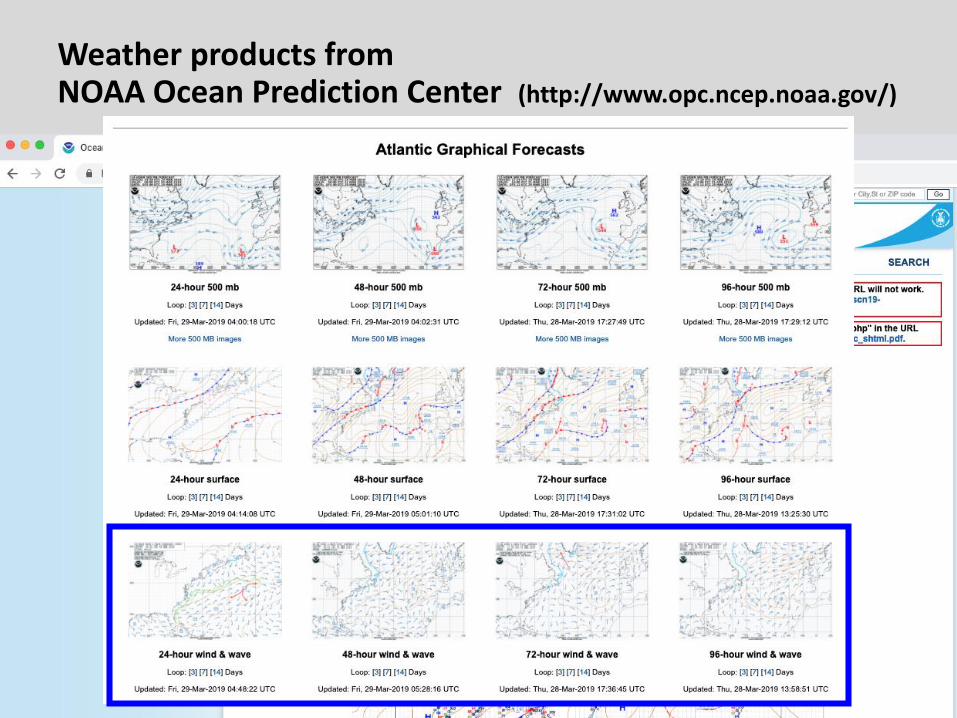
Weather products from NOAA Ocean Prediction Center (http://www.opc.ncep.noaa.gov/)

Weather products from NOAA Ocean Prediction Center (http://www.opc.ncep.noaa.gov/)

Weather products from NOAA Ocean Prediction Center (http://www.opc.ncep.noaa.gov/)

How do I interpret all the symbols & notation?

How do I interpret all the symbols & notation?

How do I interpret all the symbols & notation?

Image source: www.opc.ncep.noaa.gov
Let us identify some features on this Surface Analysis map:

Surface map “ISSUED” time analysis was
released “VALID” Time conditions
apply UTC/GMT/Zulu time
Image source: www.opc.ncep.noaa.gov
Let us identify some features on this Surface Analysis map:
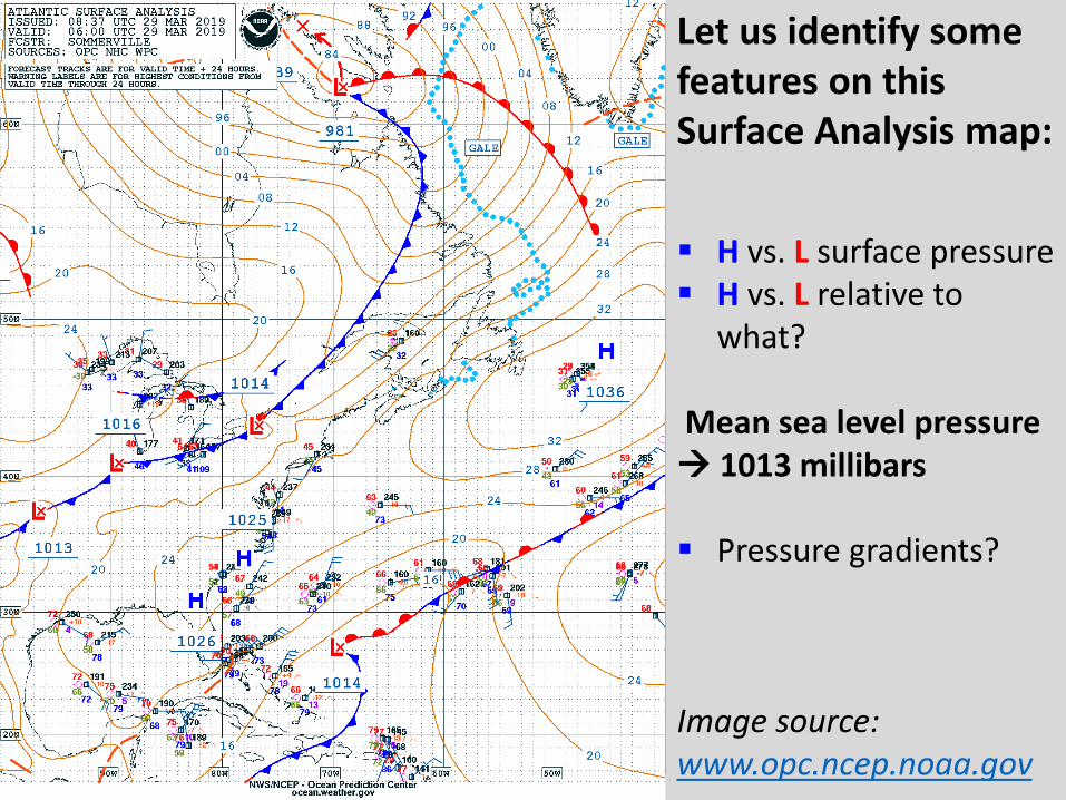
H vs. L surface pressure H vs. L relative to
what?
Mean sea level pressure 1013 millibars
Pressure gradients?
Image source: www.opc.ncep.noaa.gov
Let us identify some features on this Surface Analysis map:

Image source: www.opc.ncep.noaa.gov
Let us identify some features on this Surface Analysis map:
Interpreting a station model

Interpreting a station model: What information are we given?
Image source: http://www.wpc.ncep.noaa.gov/html/stationplot.shtml

Interpreting a station model: What information are we given?
Image source: http://www.wpc.ncep.noaa.gov/html/stationplot.shtml
Pressure range is 960 mb to 1060 mb…. Add 9 or 10 to front of number

How do we forecast where surface systems will move?
Look UP!

Image source: www.opc.ncep.noaa.gov
Let us identify some features on this Surface Analysis map:
Where will our surface systems move to?
Will they intensify or weaken?

500mb Chart: forecast -- Gives us the height where we reach 500mb of pressure

500mb Chart vs. Surface chart

500mb Chart: forecast -- Gives us the height where we reach 500mb of pressure

Let us track where our surface Low goes…...
L

500mb Chart: forecast -- Gives us the height where we reach 500mb of pressure
L

24-hour forecasted surface map
L

48-hour forecasted surface map
L
Weather products from NOAA Ocean Prediction Center (http://www.opc.ncep.noaa.gov/)

Weather BasicsSafety at Sea Seminar, 30th March 2019
Dr. Gina HendersonOceanography Dept., USNA
Session goals:
Identify global wind patterns
Wind flow around surface Highs & Lowso 3 types of Lows to look out foro Weather on the ground?
Severe weather on the Bay & in the North Atlantic
Interpret main features on a surface weather chart

Resources to learn more……
Online "school for weather" called JetStream, that is provided by NOAA and offers lots of information if you would like to learn more
o https://www.weather.gov/jetstream/
For more in-depth information, the following text book is what we currently use at the Academy for teaching synoptic meteorology:
ohttps://www.amazon.com/Midlatitude-Synoptic-Meteorology-Dynamics-Forecasting/dp/1878220101