weather forecasting: traditional knowledge of the … forecasting: traditional knowledge of the...
TRANSCRIPT

_____________________________________________________________________________________________________ *Corresponding author: Email: [email protected], [email protected];
Journal of Geography, Environment and Earth Science International
3(3): 1-14, 2015; Article no.JGEESI.19016
SCIENCEDOMAIN international
www.sciencedomain.org
Weather Forecasting: Traditional Knowledge of the People of Uttarakhand Himalaya
Piyoosh Rautela1* and Bhavna Karki1
1Department of Disaster Management, Disaster Mitigation and Management Centre, Uttarakhand
Secretariat, Rajpur Road, Dehradun – 248 001, Uttarakhand, India.
Authors’ contributions
This work was carried out in collaboration between both authors. Both authors read and approved the final manuscript.
Article Information
DOI: 10.9734/JGEESI/2015/19016
Editor(s): (1) Prof. Anthony R. Lupo, Department of Soil, Environmental, and Atmospheric Science, University of Missouri, Columbia,
USA. Reviewers:
(1) Anonymous, Kenya. (2) Anonymous, Ioannina University, Greece.
(3) Hongli Wang, National Center for Atmospheric Research, Boulder, Colorado, USA. (4) Anonymous, Argentine Institute Snow Research and Glaciology, Argentina.
Complete Peer review History: http://sciencedomain.org/review-history/10542
Received 21st May 2015 Accepted 15
th July 2015
Published 14th August 2015
ABSTRACT Aims: The objective of this study is to highlight and document indigenous weather forecasting knowledge of the people of Higher Himalaya in Uttarakhand so that the same could be improvised and used effectively for disaster risk reduction in remote and inaccessible areas. Study Design: The study is based on interactions with the community members in identified habitations of the four valleys selected for this research in Uttarakhand Himalaya. Place and Duration of Study: Four valleys in the state of Uttarakhand, India are taken up for the study; Johar, Byans and Niti valleys together with upper reaches of Bhagirathi valley. The data is collected between June 2012 and January 2015 through fieldwork carried out in the area. Methodology: The present study is based on the response of 871 persons of the selected 73 Higher Himalayan villages of Uttarakhand, recorded using a specially designed semi-structured questionnaire. Besides this, perception of the people is also gathered through focused group discussions, in-depth interviews and key informant interviews. Special care is taken to select elderly people for response as they have memories of longer time span and 50 percent of the respondents are more than 50 years in age. Special care is also taken to ensure gender balance.
Original Research Article
Rautela and Karki; JGEESI, 3(3): 1-14, 2015; Article no.JGEESI.19016
2
Conclusion: Traditional weather forecasting is used by the people of the study area for local level decision making in pursuits related to travel and agriculture as also for capturing timely information related to possible hazardous events. It is perceived that the traditional knowledge of the people is based upon uniformity of weather pattern that has lately been disturbed by climate change. People are therefore finding it increasingly difficult to use this knowledge effectively. The elderly persons however have faith in this knowledge. Backed with their experience they are able to improvise and include more reliable indicators for weather prediction. Formal recognition is however a must for these practices to be better utilized by the masses as also for planning process. Integrating this knowledge with the modern science can help in better understanding of various climate related parameters and in managing climate risk.
Keywords: Himalaya; weather forecasting; climate change; traditional knowledge; coping mechanisms; early warning.
1. INTRODUCTION
Weather forecasting, as understood today, relates to capability of assessing weather conditions in advance. This is done presently by analyzing huge volume of meteorological data collected from across the globe on real time basis and integrating the same with numerical weather prediction models using high end computing machines. Though not equipped with scientific instrumentation and analytical tools and techniques the local communities across the globe have developed the art of assessing weather conditions using their experience, observation and accumulated knowledge of generations. It is largely based on keen observation of various faunal, floral and other physical changes in their surroundings that precede or accompany meteorological phenomenon of larger interest. Weather forecasting ensured success of farming operations, with the exception of intermittent disasters [1].
Climate change is reportedly increasing level of weather extremes and variability, and high altitude ecosystems are considered particularly sensitive to these [2]. Scientific evidence on variability of events such as droughts and floods suggests that climatic oscillations have occurred in the past and may occur in future, potentially with large impacts on human society, economy and ecosystems [3]. The fragile landscapes of the Himalayan region are highly susceptible to natural hazards, leading to ongoing concern about current and future climate change impacts in the region [4]. Climate change concerns in the Himalayas are multifaceted and encompass floods, droughts, landslides [5], human health, biodiversity, endangered species, agriculture, livelihood, and food security [6]. There is evidence to show that slow and gradual changes in climate over the earth's history have been
interspersed with abrupt changes such as rapid cooling, warming, wetting and drying due to the forcing of earth systems across thresholds [7]. Adverse effects of climate change are threatening to undo decades of development efforts and negatively impact agriculture, health, settlements, and infrastructure in developing countries [8,9,10]. Changes in some types of extreme events are already being observed, for example, increase in frequency and intensity of heat wave and heavy precipitation events [11]. In longer term, global warming could lead to a rise in the snowline and disappearance of many glaciers causing serious impacts on the populations relying on the seven main rivers in Asia that are fed by melt water from the Himalayas. Throughout Asia one billion people could thus face water shortage leading to drought and land degradation by the 2050s [4,12].
From the very beginning weather conditions had a major influence on life and life support strategy of the people of the study area. This mostly revolved around trade, pastoralism and limited agriculture. Over the course of history and up to this day traditional local communities continue to rely heavily on their indigenous knowledge systems for dealing with natural hazards. These communities, particularly those living in hazard prone areas, have collectively generated a vast body of knowledge on disaster prevention and mitigation, early warning, preparedness, response and post - disaster recovery. This knowledge is acquired through observation and study, and is often based on cumulative experience handed down from generation to
generation [13]. Local communities have always aimed to adapt to variations in their climate. To do so, they make preparations based on their resources and their knowledge accumulated through experience of past weather patterns [14].

Rautela and Karki; JGEESI, 3(3): 1-14, 2015; Article no.JGEESI.19016
3
The people of the study area were traditionally traders who used to venture on long and difficult journeys to Tibet traversing high altitude passes of Himalaya for furthering their trading interests. They thus used to traverse all through the Himalayan mountain range where vagaries of fast changing weather are still a major challenge. Judiciousness of the decision related to timing of movement was thus vital for the success of these trading ventures.
These journeys were physically demanding and only the fit ones could undertake these. Women, children and elderly, together with ill, weak and challenged persons, therefore stayed back in their summer homes in the higher reaches where they engaged in cultivation of some niche crops. Survival during the trading journeys was largely dependent on judiciousness of the assessment of weather conditions and therefore people of the area developed an elaborate system of weather forecasting that was used for deciding timing of initiating the travel and halting at safe places on the way. The precision of forecasting a fair or bad weather was important for them as a wrong decision could as well wipe out the trading expedition all together. Decisions related to travel plan and route were thus taken after thorough review of various signs of nature. The tradition thus evolved out of the instinct of these people to survive in their trade related journeys. These people used to stay in Tibet from July to October, returning in November to do further business in the lower valleys and plains of northern India [15]. They travelled with goods, halting at various places and moving on at appropriate time. The traditional weather forecasting knowledge was in the form of bio - indicators and other physical factors that include wind direction, time of the year, colour of sky and position of stars.
Weather related knowledge is at the same time highly useful for farmers and shepherds. Shepherds depend on livestock for their sustenance and count on their knowledge to decide the timing of movement and halt of the large herds during summers so as to take advantage of diverse grazing resources. Success of limited farming within short duration also depends on timing of sowing, harvest and storage that are also traditionally decided upon by the knowledge of weather conditions. Local communities and farmers have developed a rich knowledge base of predicting weather events based on observation of animals, plants, and
celestial bodies and others [16].
Roncoli and others [17] through a study in Burkina Faso have demonstrated that indigenous knowledge on rainfall forecasting can form an important part of the scientific forecasts. It is urged that understanding of local communities’ perception to predict rainfall variability can add value to the scientific weather forecasts. Despite modern technological tools for predicting weather conditions for the next day or over the season in a specific location, traditional weather lore still remains an important source of local forecasting in many areas [18]. Reference of weather forecasting is also available in ancient Indian texts that rely on observational methods to assess atmospheric changes. These include cloud forms (sky features) and biological and phenological indicators [18].
The traditional weather forecasting knowledge of the people has the potential of being utilized for making modern weather related predictions more robust and effective but if not documented this rich knowledge of the people is likely to be lost forever. This study is thus designed to highlight and document indigenous weather forecasting knowledge of the people. The focus of the research is on recording the observations of the community members regarding changes in outer environment and on getting into collective experiences rather than on cross sectional comparative analysis of the impact of climate change.
2. THE STUDY AREA
Johar, Byans and Niti valleys together with upper reaches of Bhagirathi valley are taken up for the present study (Fig. 1). 73 villages of these valleys are covered by this study; 26 in the upper reaches of Bhagirathi river valley (Fig. 2), 16 in Niti valley (Fig. 3), 24 in Johar valley and 7 in Byans valley (Fig. 4). Except for Bhagirathi valley were the selected villages are located in the altitudinal rage of 750 to 2620 meters above mean sea level (msl), all other villages are located between 2200 and 3600 meters above msl.
Bhotiya tribe constitutes majority population of the study area. Though agro – pastoralism is presently the major economic activity of the area trans-Himalayan trade used to be traditional pursuit of these people. For this they used to maintain large animal herds; particularly those of sheep and yak that were utilized for transporting various tradable commodities from terai, in the foothills of Himalaya that used to be their abode

Rautela and Karki; JGEESI, 3(3): 1-14, 2015; Article no.JGEESI.19016
4
during harsh winter months, to Tibet traversing high-altitude passes and rugged Himalayan terrain.
Sugar, gur, misri, tobacco, spices, pulses, grain, coffee, vegetable oil, ghee and various miscellaneous consumable items constituted the package carried across [19] and commodities imported from Tibet included god dust, shawl wool (pashmina), sheep, goats, mules, ponies and horses, rugs, blankets, shawls, skins, yak
trails (used in Hindu rituals), musk, drugs and
parts of medicinal plants [20,21,22,23]. These tradable commodities essentially included products bartered by these people on way with local inhabitants. Local fairs of the region that coincided with the movement schedule of these migratory traders ensured that the local producers fetch a fair deal. Besides ensuring variety this at the same time infused new vigour into the economy of this region.
Fig. 1. Location of the four valleys in Pithoragarh, Chamoli and Pithoragarh districts taken up under the present
study
Fig. 2. Location of the villages covered under the study in Bhagirathi valley of Uttarkashi district
Fig. 3. Location of the villages covered under the study in Niti valley of Chamoli
district
Fig. 4. Location of the villages covered under
the study in Johar (Goriganga river) and Byans (Kali river) valleys of Pithoragarh district

Rautela and Karki; JGEESI, 3(3): 1-14, 2015; Article no.JGEESI.19016
5
The people of the area traditionally crossed over to Tibet through a number of identified passes. For the people of Johar valley it was Gonkhal Dhar, a ridge defining the eastern border of Milam village, where the traders were given a hearty send-off and accorded a warm welcome on their return [24]. From there route to Tibet was through Untadhura pass (5377 meters) that could be crossed between June and October [25]. People of Byans valley carried out trade through Lipulekh pass following the Kali valley and the importance of this route can well be assessed from the fact that Baz bahadur Chand, the king of Kumaun, personally supervised construction of this route [24]. En route Garbyang used to be a major trading destination and the importance of the same can well be assessed from ornate
multistoreyed buildings of the area [26]. In the Garhwal region trans - border trade was carried out through Niti, Mana [27] and the Nilang passes. The way to Niti pass was along Dhauliganga, Mana pass was through the higher reaches of the Alaknanda beyond Badrinath and Nilang pass was accessed through narrow gorge of Jadganga beyond Harsil.
For centuries these valleys have formed important sections of trade routes connecting the Indian subcontinent with Tibet and Central Asia [28]. The direct trade and transport across the high altitude passes was operated by different Bhotiya groups, who for a number of reasons were able to maintain monopoly over this trade from which they could accumulate substantial
wealth [20,29,30].
After the Sino-Indian war of 1962 the border was closed and this flourishing traditional commerce was suddenly disrupted. This forced the people to pay attention towards settled agriculture for supplementing their income. Lipulekh pass of the study area is first Indian border post to be opened for trade with China in 1992. This was followed by the opening of Shipki La in Himachal Pradesh in 1994 and Nathu La in Sikkim in 2006 [31]. Presently, Lipulekh pass is open for cross-border trade every year from June through September and people of the area still engage in traditional cross border trade. Their ethnic characteristics and linguistic skills together with traditional acumen to traverse difficult terrain that is still largely traversed on foot help them dominate this trade. Most people of the study area still resort to seasonal migration and live at high altitude in summer (May - June to October -
November) and migrate to lower altitudes around November till April. 3. METHODOLOGY Purposive sampling is used for the selection of geographical area and villages taken up under the present study. This method has been used in the present qualitative research for maximizing relevant representation based on prior knowledge. This is based on both primary and secondary sources of information as also extensive desk review undertaken before designing the research process and instruments. This study is based on the response of the people of the selected villages recorded using a specially designed semi-structured questionnaire. Focused group discussions (FGD), in-depth interviews (IDI) and key informant interviews (KII) were also done to recording perception of 871 persons on climate change, its impact and traditional methods of weather forecasting. Elderly people are specially selected for the study as they have memories of longer time span.
Data collection was difficult because people are little hesitant in giving the details to outsiders. Major portion of the fieldwork had thus to be devoted towards confidence building with local communities. There is at the same time lack of well – documented information or secondary data on this subject from the area. Data collected is mainly qualitative and based on the percentages. Attempt has been made to assess the perception of the community for forecasting relevant weather events. The focus was on collecting and documenting the information from the community and cross checking and analysing the same with various secondary sources.
The word forecast as used in the study refers to short – term assessment of weather conditions; up to one week. Traditional knowledge is explained as the knowledge of a group or a community from a particular area, based on their environmental understanding, interacting with nature and experiences within their area [32,33]. As defined by De Boef and others [33] the term traditional knowledge is used here as the knowledge of the people of the study area based on their interactions and experiences within that area, their traditions, and their incorporation of knowledge emanating from elsewhere into their production and economic systems [33].

Rautela and Karki; JGEESI, 3(3): 1-14, 2015; Article no.JGEESI.19016
6
4. RESULTS AND DISCUSSION
Responses of 871 persons from 73 villages of the four identified valleys are recorded using a specially designed semi-structured questionnaire (Table 1). Besides this a total of 12 FGDs, 24 IDIs and 30 KIIs are also conducted. Information contained in the folklores, sayings, folksongs, folktales and various religio-magical rites and traditional practices of the masses is at the same time analysed for better understanding of their efficacy in effective resource management.
Table 1. Details of respondents (n = 871)
Valley Villages covered
Number of respondents Total Male Female
Bhagirathi 26 312 134 178 Niti 16 205 141 64 Johar 24 201 67 134 Byans 7 153 59 94 Total 73 871 401 470
Gender balance is adhered to in the study and 54 percent of the respondents are females. As for the age profile almost half of the respondents (49 percent) are more than 50 years old (Fig. 5).
Fig. 5. Age group of the repondents in the four valleys
The forecast and bio- indictors used by people for weather forecasting in the study area are observed to be based on their long-standing familiarity with seasonal patterns of precipitation, temperature, wind and cloud pattern, position of stars, behaviour of animals and birds and other similar indicators and observations. These are grouped together based upon the parameters used for weather forecasting. The same are summarised in Table 2.
4.1 Floral Indicators
Blossoming peach (Prunus persica), apricot (Prunus armeniaca), fig (Ficus sp.) or budding in other trees in the surrounding farms is considered to indicate onset of
spring. Emergence and growth of new leaves indicates that the temperature is increasing and winter season is drawing to an end.
Abundant blossoming of peach, apricot and other trees is considered an indicator of good rainy season.
Flourishing of mushrooms, both edible and wild, is considered to indicate imminent rain as the same is associated with high humidity.
Physical state and flexibility of pine (Pinus sp.) cones is traditionally utilized by the people of the study area for assessing humidity in the atmosphere and predicting rainfall. The pine cones generally tend to open up and become stiff in dry weather but in the presence of high humidity these become flexible and often regain their original shape. It is this variation in the physical state of pine cones with changing humidity that is utilized for assessing humidity content in the air and predicting rainfall.
Flowers of certain lower plants open up in fine weather. In case the petals of these plants remain closed it is considered to indicate rain and bad weather.
Appearance of young leaves and grass in the mountains, particularly in the pastures, is considered to indicate good rains.
Dropping of fruits or drying of flowers before maturity is considered to indicate forthcoming very dry season.
4.2 Cloud Colour and Pattern
Dark clouds are considered to indicate heavy rainfall within a few hours.
Dark clouds approaching from north are considered to bring rain.
Red / pink clouds in the morning are considered to indicate possibility of rain where as red / pink clouds in the evening are considered to indicate that there would be no rain.
Dark clouds preceding strong winds are considered to indicate thunderstorm in a few hours.
Wind getting fast with a particular colour and movement pattern of clouds is considered to indicate rain.
4.3 Moisture In villages elderly farmers usually carry a
small bag of tambaku (tobacco) for hukka
Rautela and Karki; JGEESI, 3(3): 1-14, 2015; Article no.JGEESI.19016
7
(traditional smoking pipe). Moisture over the hukka is considered to indicate rain.
Moisture on dried chillies or tobacco leaves is considered to indicte high humidity and imminent rain.
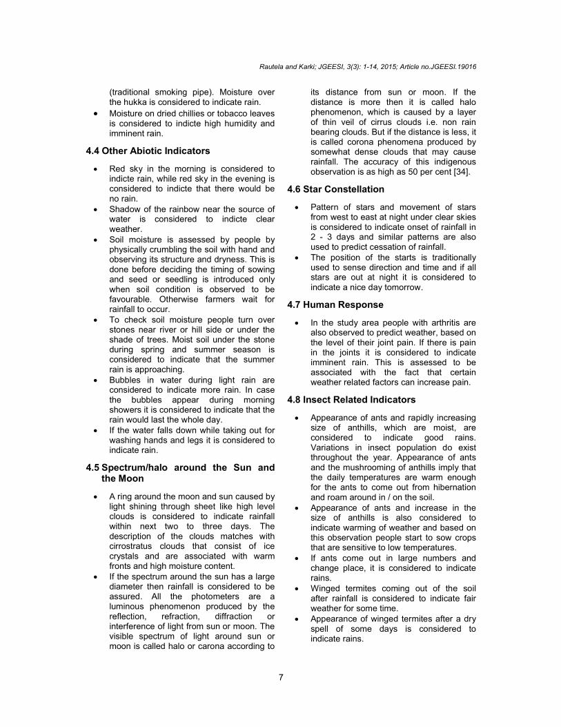
4.4 Other Abiotic Indicators
Red sky in the morning is considered to indicte rain, while red sky in the evening is considered to indicte that there would be no rain.
Shadow of the rainbow near the source of water is considered to indicte clear weather.
Soil moisture is assessed by people by physically crumbling the soil with hand and observing its structure and dryness. This is done before deciding the timing of sowing and seed or seedling is introduced only when soil condition is observed to be favourable. Otherwise farmers wait for rainfall to occur.
To check soil moisture people turn over stones near river or hill side or under the shade of trees. Moist soil under the stone during spring and summer season is considered to indicate that the summer rain is approaching.
Bubbles in water during light rain are considered to indicate more rain. In case the bubbles appear during morning showers it is considered to indicate that the rain would last the whole day.
If the water falls down while taking out for washing hands and legs it is considered to indicate rain.
4.5 Spectrum/halo around the Sun and the Moon
A ring around the moon and sun caused by light shining through sheet like high level clouds is considered to indicate rainfall within next two to three days. The description of the clouds matches with cirrostratus clouds that consist of ice crystals and are associated with warm fronts and high moisture content.
If the spectrum around the sun has a large diameter then rainfall is considered to be assured. All the photometers are a luminous phenomenon produced by the reflection, refraction, diffraction or interference of light from sun or moon. The visible spectrum of light around sun or moon is called halo or carona according to
its distance from sun or moon. If the distance is more then it is called halo phenomenon, which is caused by a layer of thin veil of cirrus clouds i.e. non rain bearing clouds. But if the distance is less, it is called corona phenomena produced by somewhat dense clouds that may cause rainfall. The accuracy of this indigenous observation is as high as 50 per cent [34].
4.6 Star Constellation
Pattern of stars and movement of stars from west to east at night under clear skies is considered to indicate onset of rainfall in 2 - 3 days and similar patterns are also used to predict cessation of rainfall.
The position of the starts is traditionally used to sense direction and time and if all stars are out at night it is considered to indicate a nice day tomorrow.
4.7 Human Response
In the study area people with arthritis are also observed to predict weather, based on the level of their joint pain. If there is pain in the joints it is considered to indicate imminent rain. This is assessed to be associated with the fact that certain weather related factors can increase pain.
4.8 Insect Related Indicators
Appearance of ants and rapidly increasing size of anthills, which are moist, are considered to indicate good rains. Variations in insect population do exist throughout the year. Appearance of ants and the mushrooming of anthills imply that the daily temperatures are warm enough for the ants to come out from hibernation and roam around in / on the soil.
Appearance of ants and increase in the size of anthills is also considered to indicate warming of weather and based on this observation people start to sow crops that are sensitive to low temperatures.
If ants come out in large numbers and change place, it is considered to indicate rains.
Winged termites coming out of the soil after rainfall is considered to indicate fair weather for some time.
Appearance of winged termites after a dry spell of some days is considered to indicate rains.

Rautela and Karki; JGEESI, 3(3): 1-14, 2015; Article no.JGEESI.19016
8
If the spiders leave their webs, this is considered to indicate rains. Spiders generally abandon their web and seek shelter with drop in atmospheric pressure and this observation is utilized by the people for predicting rains.
Sound of crickets calling or chirping throughout the night is considered to indicate change in weather.
When the bees come out of their hives it is considered a sign of clear weather.
Sight of bees moving untimely and in large numbers towards their hives is considered to indicate bad weather and rain.
4.9 Bird Related Indicators
Flock of small birds like common swallows (Hirundo rustica) together with proceeding black clouds is considered to indicate rain.
Birds taking dip in water is considered to indicate imminent rain.
Sight of red billed chough (Pyrrhocorax pyrrhocorax) is considered to indicate that the higher reaches have experienced snow and winter conditions are setting in.
Crow spreading and moving its wings near river or source of water is considered to indicate dry spell.
Flocks of birds flying high in the sky is considered to indicate fair weather. If the birds fly below their normal flight height this is considered to indicate rain or bad weather. Fall in air pressure due to bad weather conditions causes discomfort in birds' ears and in order to alleviate it they fly at lower elevations. Increase in humidity, at times of bad or wet weather, draws insects to the surface and this is another reason for insect-seeking birds to fly low.
Flock of sparrows flying around the sky with scattered clouds is considered to indicate rain in the afternoon.
Ground nesting bird species making their nest on higher ground is considered to indicate likely increase in water level of the water body (river / stream). The red-wattled lapwing (Vanellus indicus) generally lays eggs on bare ground and never constructs a nest. Laying of eggs by the lapwing on high ground is considered to indicate rise in water level of streams and rivers.
Migration and immigration of birds is considered an indicator changing season.
Loud chirping of birds in group and taking dip in water is considered to indicate rain.
Particular sound of the birds together with atmosphere becoming unusually calm is considered to indicate rains.
4.10 Animal Behaviour Grazing cows / yaks, juppu in local
parlance, returning home early is considered to indicate rains or bad weather.
Well-fed cows / calves jumping in herd on their way home from mountain pastures is considered to indicate rains or bad weather.
Grazing cows returning home early with raised tails is considered to indicate rains.
Consumption of excess fodder by cattle is considered to indicate harsh weather or dry conditions.
Croaking of frogs during afternoon is considered to indicate imminent rain during all seasons.
Sight of domestic hen / cocks searching food during rain is considered to indicate that the rain would continue. But if these do not search for food during rain it is considered to indicate that the rain would stop soon.
If the goats do not graze it is considered to indicate snowfall.
If burrowing animals like rats come out of their burrows and start to dig the ground it is considered to indicate some natural calamity.
Weeping like sound of animals is considered a bad omen and correlated with natural calamities.
4.11 Appearance of Reptiles
Sight of certain snakes moving down the mountain is considered to indicate good rains. Snakes generally come out of hibernation and proceed to downhill areas in search for prey and mating partners so as to reproduce in early summer season. This is to ensure that the eggs are hatched in time and baby snakes get enough time to fatten their bodies and prepare for cold season when they have to hibernate [35].
4.12 Earthquakes
Although not falling in the category of weather forecasting, animals, birds and
Rautela and Karki; JGEESI, 3(3): 1-14, 2015; Article no.JGEESI.19016
9
insects are believed to sense the approaching earthquake waves well in advance. This is believed to induce abnormal behaviour in these and the same is considered an indicator of an imminent earthquake.
It is believed that a few minutes prior to the earthquake, everything becomes completely still (no movement and no sound) e.g. birds chirping and flying around. Insects cease to make noise and stop to move around and there is total
silence and stillness. This unusual calm is considered to indicate earthquake activity.
Seconds before the earthquake it is believed that the dogs start to howl and other animals too become agitated and restless. After the earthquake has passed, similar silence is repeated for a couple of minutes.
Animals and birds have also been known to leave an area or region up to 48 hours prior to a major earthquake, not returning until well after the event [36].
Table 2. Traditional weather forecasting / prediction indicators
Indicator Observation Indicates
Floral indicators Blossoming peach (Prunus persica), apricot (Prunus armeniaca), fig (Ficus sp.)
Onset of spring
Budding or emergence and growth of new leaves in other trees
Increasing temperature & end of winter season
Abundant blossoming of peach, apricot and other trees
Forthcoming good rainy season
Flourishing -both edible and wild mushrooms High humidity, imminent rain
Opened and stiff pine cones Dry wind/ weather Flexible pine cone Good humidity content in the air and
imminent rain
Opening and closing of flowers of certain lower plants
Open up - fine weather.
Closed -indicate rain and bad weather.
Appearance of young leaves and grass in the mountains/pastures
Forthcoming good rain
Dropping of fruits or drying of flowers before maturity
Forthcoming very dry season
Cloud colour and pattern
Dark clouds Heavy rainfall within a few hours
Dark clouds approaching from north Imminent rain
Red / pink clouds in the morning Possibility of rain
Red / pink clouds in the evening No rain
Dark clouds preceding strong winds Thunderstorm in a few hours Wind getting fast with a particular colour and
movement pattern of clouds Indicates rain
Moisture Moisture over the hukka (traditional smoking pipe)
High humidity, imminent rain
Moisture on dried chillies or tobacco leaves High humidity, imminent rain.
Other abiotic indicators
Red sky in the morning Rain
Red sky in the evening No rain Shadow of the rainbow near the source of water Clear weather
Soil easily crumbled with hand Dry condition
Soil most or soft when crumbled with hand Good moisture content in soil
Moist soil under the stones near river or hill side or under the shade of the tree during spring and summer season
Summer rain approaching
Bubbles in water during light rain More rain In case the bubbles appear during morning
showers The rain would last the whole day
If the water falls down while taking out for Imminent rain
Rautela and Karki; JGEESI, 3(3): 1-14, 2015; Article no.JGEESI.19016
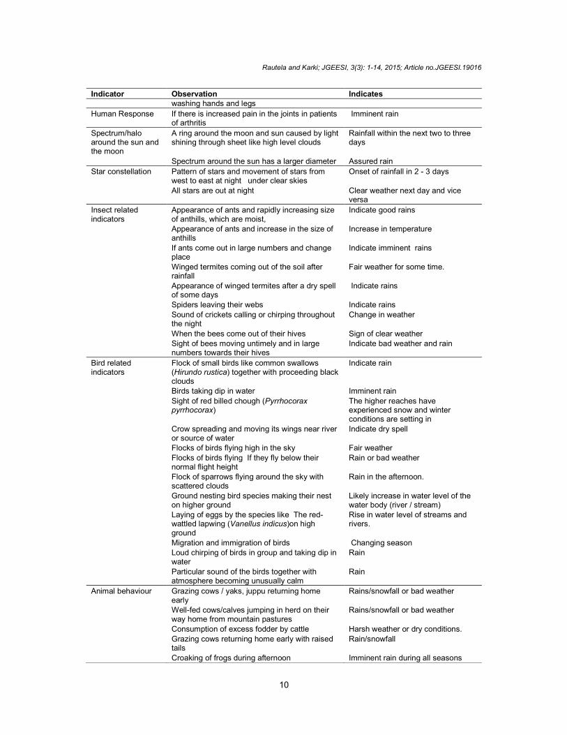
10
Indicator Observation Indicates washing hands and legs
Human Response If there is increased pain in the joints in patients of arthritis
Imminent rain
Spectrum/halo around the sun and the moon
A ring around the moon and sun caused by light shining through sheet like high level clouds
Rainfall within the next two to three days
Spectrum around the sun has a larger diameter Assured rain
Star constellation Pattern of stars and movement of stars from west to east at night under clear skies
Onset of rainfall in 2 - 3 days
All stars are out at night Clear weather next day and vice versa
Insect related indicators
Appearance of ants and rapidly increasing size of anthills, which are moist,
Indicate good rains
Appearance of ants and increase in the size of anthills
Increase in temperature
If ants come out in large numbers and change place
Indicate imminent rains
Winged termites coming out of the soil after rainfall
Fair weather for some time.
Appearance of winged termites after a dry spell of some days
Indicate rains
Spiders leaving their webs Indicate rains
Sound of crickets calling or chirping throughout the night
Change in weather
When the bees come out of their hives Sign of clear weather Sight of bees moving untimely and in large
numbers towards their hives Indicate bad weather and rain
Bird related indicators
Flock of small birds like common swallows (Hirundo rustica) together with proceeding black clouds
Indicate rain
Birds taking dip in water Imminent rain
Sight of red billed chough (Pyrrhocorax pyrrhocorax)
The higher reaches have experienced snow and winter conditions are setting in
Crow spreading and moving its wings near river or source of water
Indicate dry spell
Flocks of birds flying high in the sky Fair weather
Flocks of birds flying If they fly below their normal flight height
Rain or bad weather
Flock of sparrows flying around the sky with scattered clouds
Rain in the afternoon.
Ground nesting bird species making their nest on higher ground
Likely increase in water level of the water body (river / stream)
Laying of eggs by the species like The red-wattled lapwing (Vanellus indicus)on high ground
Rise in water level of streams and rivers.
Migration and immigration of birds Changing season Loud chirping of birds in group and taking dip in
water Rain
Particular sound of the birds together with atmosphere becoming unusually calm
Rain
Animal behaviour Grazing cows / yaks, juppu returning home early
Rains/snowfall or bad weather
Well-fed cows/calves jumping in herd on their way home from mountain pastures
Rains/snowfall or bad weather
Consumption of excess fodder by cattle Harsh weather or dry conditions.
Grazing cows returning home early with raised tails
Rain/snowfall
Croaking of frogs during afternoon Imminent rain during all seasons

Rautela and Karki; JGEESI, 3(3): 1-14, 2015; Article no.JGEESI.19016
11
Indicator Observation Indicates
Sight of domestic hen/cocks searching food during rain
Rain would continue and vice versa
If the goats do not graze Snowfall
If burrowing animals like rats come out of their burrows and start to dig the ground
Some natural calamity like earthquake
Weeping like sound of animals Bad omen and correlated with natural calamities
Abnormal behaviour of animals
Everything becomes completely still (no movement and no sound) e.g.
Birds chirping and flying around
Insects cease to make noise and stop to move around and there is total silence and stillness.
Dogs start to howl and other animals too become agitated and restless.
Earthquake
Appearance of reptiles
Sight of certain snakes moving down the mountain
Good rain
5. DISCUSSION Traditional weather forecasting refers to the use of various indicators for assessing weather conditions. The mechanisms and indicators used for forecasting however differ across communities, cultural backgrounds and environments. In South Africa and Western Kenya, inhabitants use birds, toads, and white ants to predict the summer season and onset of rains. Based on their observation they at the same time can predict temperature variation in the range of 18°C to 26°C [37,38]. In the northeastern Brazil appearance of crickets is used while in Tanzania forecast is made on the basis of behavioral patterns of birds and mammals. Activities of arthropods, such as fleas, cockroaches, houseflies, spiders and many others are considered to indicate arrival of the summer season in Japan [39,40]. Similar indicators and forecasting methods are observed all over the world.
The main advantage of traditional weather forecast is its simplicity and timeliness; a person can make an independent observation without use of complicated instruments and make use of the information when needed without resorting to complex analysis of the collected information. There is no need for consultation with experts and in fact the indicators observed by people in their immediate environment provide more accurate information than forecasts interpolated from data of the weather stations located at distant places. This holds good for remote and inaccessible terrains such as that of Uttarakhand where most meteorological observatories are restricted to district headquarters and the data from the same is extrapolated for making
predictions over large geographical areas. Remoteness of the places also hinders the accessibility of the people to scientific weather forecasts through television, newspapers or radio. This is important because before the onslaught of modern scientific methods for weather forecasting and climate prediction, farming and other livelihood pursuits were sustained by this traditional knowledge. Traditional knowledge can thus be used in conjunction with scientific weather forecasting information from meteorological department specially to improve the timing of agro-horticultural activities and for disaster risk reduction. The challenges for the integration of this traditional knowledge with mainstream science include the fact that observed environmental indicators lack sufficient scientific data for validation. The knowledge is based on cultural belief system of the people and often varies with different cultures and there is still no formal intergenerational transfer of knowledge amongst the communities. The indicators are based on ecological interactions and response of the indicator species, which is being altered by increasing variability in climate thus making these predictions increasingly less reliable. For possible integration of scientific weather forecasting and traditional knowledge there is need for extended research to correlate local indicators used for weather prediction with meteorological parameters. Agricultural decisions like sowing, planting, harvesting is still made

Rautela and Karki; JGEESI, 3(3): 1-14, 2015; Article no.JGEESI.19016
12
according to traditional knowledge and understanding of local environmental conditions. Understanding peoples’ perceptions of weather and climate is an important step in facilitating and promoting research on modern science – powered traditional agro – meteorological knowledge.
6. CONCLUSION Bereft of external interventions, the geo-environment around most local communities behaved as a closed system with little faunal and floral changes. Moreover there were little variations in the weather pattern. Though based upon intricate observation and record keeping of generations, the likelihood of the predictions being correct was at that time relatively high. Changed ground realities and changes being introduced in weather conditions by climate change are however making traditional weather forecasting tools increasingly unreliable. This is leading to mistrust amongst masses regarding the efficacy of traditional indicators. The elderly people however have faith in these and based upon their experience they resort to the use of multiple indicators for effective and reliable predictions. In the changed ground the traditional art of weather forecasting is fast loosing ground and being transmitted through oral tradition this knowledge is sure to be lost soon as the community would be disinterested in putting in effort for transmitting irrelevant knowledge. This knowledge is however the product of in depth observation and detailed documentation of natural phenomenon over an appreciably long span of time and therefore detailed scientific documentation of this knowledge together with standardization of indicators that are still pertinent is a must. This if done in right spirit and results made available to the masses, could greatly empower local communities. This effort, at the same time, would have the scope of initiating an all together new line of research wherein modern weather forecasting skills could be further sharpened though the incorporation of real time inputs on the standardized indicators from the community. Besides empowering the local communities this effort would be beneficial for the state as also others as improved weather forecasting would translate into better decision making, improved economic scenario and reduced loss from recurring disasters.
ACKNOWLEDGEMENTS Partial financial support for the study from Uttarakhand Council for Science and Technology, Government of Uttarakhand and Government of India – UNDP supported Climate Change Project is gratefully acknowledged.
COMPETING INTERESTS Authors have declared that no competing interests exist.
REFERENCES 1. Camberlin P. Rainfall anomalies in the
source of the Nile and their connection with the Indian Summer Monsoon. J. Clim. 1997;10:1380-1392.
2. Patz JA, Campbell-Lendrum D, Holloway T, Foley JA. Impact of Regional Climate Change on Human Health, Nature. 2005; 438(7066):310-317. DOI:10.1038/nature04188
3. Fisher RJ. If rain doesn’t, come: An Anthropological study of Drought and Human Ecology in Western Rajasthan, Sydney Studies, Manohar Publishers and Distributors; 1997.
4. Cruz RV, Harasawa H, Lal M, Wu S, Anokhin Y, Punsalmaa B, Honda Y, Safari M, Li C, Huu Ninh N. Asia. Climate Change, Impacts, Adaptation and Vulnerability. In Parry ML, Canziani OF, Palutikof JP, Van Der Linden PJ, Hanson CE, (Eds.) Contribution of Working Group II to the Fourth Assessment Report of the Intergovernmental Panel on Climate Change. Cambridge University Press, Cambridge, UK. 2007;469-506.
5. Barnett TP, Adam JC, Lettenmaier DP. Potential Impacts of a Warming Climate on Water Availability in Snow-dominated Regions. Nature. 2005;438:303-309.
6. Xu J, Grumbine RE, Shrestha A, Eriksson M, Yang X, Wang Y, Wilkes A. The Melting Himalayas: Cascading Effects of Climate Change on Water, Biodiversity, and Livelihoods. Conservation Biology. 2009; 23:520-530.
7. Bharara LP, Indigenous Knowledge-A Coping Mechanism in Drought-prone Areas, and Changes and Consequences of Accelerating Risks and Vulnerability to Desertification in Western Rajasthan, Paper presented at Seminar on control of
Rautela and Karki; JGEESI, 3(3): 1-14, 2015; Article no.JGEESI.19016
13
Drought, Desertification and Famine, New Delhi, Mimeo; 1986.
8. IPCC (Intergovernmental Panel on Climate Change) Climate change: The physical science basis. In: Averyt KB, Tignor M, Miller HL, Eds. Contribution of Working Group I to the Fourth Assessment Report of the Intergovernmental Panel on Climate Change, Cambridge University Press, Cambridge; 2007. Available:http://www. ipcc.ch/ publications_and_data/publications_ipcc_fourth_assessment_report_wg1_report_the_physical _science_basis.htm
9. Padgham J. Agricultural development under a changing climate: Opportunities and challenges for adaptation, joint departmental discussion paper-issue 1, agriculture and rural development & environment departments. The World Bank, Washington DC; 2009.
10. Thornton PK, Jones PG, Ericksen PJ, Challinor AJ. Agriculture and food systems in sub-Saharan Africa in a 4°C + world. Philosophical Transactions A. 2011;369: 117-136. Available:http://dx.doi.org/10.1098/rsta.2010.0246
11. Meehl GA, Stocker TF, Collins WD, Friedlingstein P, Gaye AT, Gregory JM, Kitoh A, Knutti R, Murphy J M,Noda A, Raper SCB, Watterson IG, Weaver AJ, Zhao ZC. Global Climate Projections. In: Climate Change 2007: The Physical Science Basis. Contribution of Working Group I to the Fourth Assessment Report of the Intergovernmental Panel on Climate Change [Solomon S, Qin D, Manning M, Chen Z, Marquis M, Averyt K B, Tignor M and Miller H L (eds)]. Cambridge University Press. Cambridge, United Kingdom and New York, NY, USA; 2007.
12. Christensen JH, Hewitson B, Busuioc A, Chen A, Gao X, Held I, Jones R, Kolli R K, Kwon WT, Laprise R, Magaña Rueda V, Mearns L, Menéndez CG, Räisänen J, Rinke A, Sarr A, Whetton P. Regional Climate Projections. In: Climate Change 2007: The Physical Science Basis. Contribution of Working Group I to the Fourth Assessment Report of the Intergovernmental Panel on Climate Change [Solomon S, Qin D, Manning M, Chen Z, Marquis M, Averyt KB, Tignor M and Miller H L (eds)]. Cambridge University Press. Cambridge, United Kingdom and New York, NY, USA; 2007.
13. Grenier Louise, Working with Indigenous Knowledge: A Guide for Researcher, (International development Centre: Ottawa); 1998.
14. Climate change: Impacts, vulnerabilities And adaptation In developing countries, report by United Nations Framework Convention on Climate Change (UNFCCC); 2007.
15. Chakrabarti C. Bhotias of the Bhotia Mahal. The Himalayan Journal. 2006;62,
16. Acharya S. Presage biology: Lessons from nature in weather forecasting. Indian Journal of Traditional Knowledge 2011;10: 114-124. Available:http://nopr.niscair.res.in /handle / 1234 56 78 9 /11072
17. Roncoli C, Ingram K, Kirshen P, Jost C. (Burkina Faso: Integrating indigenous and scientific rainfall forecasting, K Notes No. 39 Africa Region’s Knowledge and Learning Center; 2001. Available:http://www.worldbank.org/afr/ik/iknt39.pdf
18. Mishra SK, Dubey VK, Pandey RC. Rain Forecasting in Indian Almanacs (Panchangs): A case for making Krishi-Panchang. Asian Agri-History. 2002;6(1): 29-42.
19. Arpi C. Border Trade: Reopening the Tibet Border; 2012. Available:http://www.claudearpi.net/maintenance/ uploaded_pics/Border_Trade.pdf
20. Brown CW. The Goat is Mine, the Load is Yours: Morphogenesis of 'Bhotiya-Shauka', U.P., India. Lund Studies in Social Anthropology 1. Lund: University of Lund, Department of Social Anthropology; 1984.
21. Dangwal DD. The Lost Mobility: Pastoralism and Modernity in Uttarakhand Himalaya (India). In: Nomadic Peoples. 2009;13(2):84-101.
22. Pant SD. The social economy of the Himalayans. Based on a survey in the Kumaon Himalayas. London: Geogre Allen and Unwin; 1935.
23. Smyth E. Remembering Pundit Nain Singh. Originally published in: Proceedings of the Royal Geographical Society and Monthly Records of Geography, New Monthly Series. 1882;4:315-317. In: Pathak, S. and Bhatt, U. (eds.): Asia Ki Peeth Per. Pundit Nain Singh Rawat [Pundit Nain Singh Rawat: Life, Explorations and Writings of Pundit Nain Singh Rawat; in Hindi]. Vol. 1. Nainital: Pahar. 2006:161-164.

Rautela and Karki; JGEESI, 3(3): 1-14, 2015; Article no.JGEESI.19016
14
24. Atkinson ET. The Himalayan Gazetteer, Cosmo Publication, Delhi; 1882.
25. Rawat BS. Travails of Border Trade - Border Trade with Western Tibet- History of Trade marts in Tibet-Conventions and Agreements Published 2009 Malla Johr Vikas Samiti, Munsayri, Pithoragarh; 2009.
26. Rautela P, Ground subsidence: a silent disaster in Himalaya, Disaster Prevention and Management: An International Journal. 2005;14(3):395-406.
27. A`rpi C. A new India's Tibet Policy; 2012. Available:http://claudearpi.blogspot.in/2012/09/a-new-indias-tibet-policy.html
28. Zurick D, Pacheco J. Illustrierter Atlas des Himalaya. Zürich: AS Verlag; 2006.
29. Gerwin M, Nüsser M. Diversity, Complexity and Dynamics: Land Use Patterns in the Central Himalayas of Kumaon, Northern India (= Colloquium Geographicum 31). Sankt Augustin: Asgard-Verlag; 2008.
30. Majumdar DN. (1949): The Social Economy of the Bhotiyas. In: Pangtey, K. S. (ed.): Lonely Furrows of the Borderland. Second PAHAR. 2005;22:11. Nainital: PAHAR.
31. Project Gutenberg Self Publishing Press, Article Lipulekh Pass; 2015. Available:http://self.gutenberg.org/articles/lipulekh_pass
32. Shumba O. Coping with Drought: Status of Integrating Contemporary and Indigenous Climate/Drought Forecasting in Communal Areas of Zimbabwe; Consultancy Report to the United Nations Development Program Office to Combat Desertification and Drought; UNSO/UNDP/WMO: Harare, Zimbabwe; 1999.
33. De Boef W, Amanor K, Wellard K, Bebbington A. Cultivating knowledge:
Genetic diversity, farmer experimentation and crop research. London: Intermediate Technology Publications; 1993.
34. FAO, Chapter 8 - Weather forecasting; 2010. (Retrieved February 20, 2015). Available:http://www.fao.org/docrep/x5672e/x5672e09.htm
35. Marais J. What’s That Snake? A Starter’s Guide to Snakes of Southern Africa; Struik Publishers: Cape Town, South Africa; 2008.
36. WEATHER - Nature's Forecasters - Animals and Birds; 2011. (Retrieved February 20; 2015). Available:http://treechange.hubpages.com/hub/WEATHER-Natures- Forecasters-Animals-and-Birds
37. Merchant ME, Flanders RV, Williams RE. Seasonal abundance and parasitism of house fly (Diptera: Muscidae) pupae in enclosed, shallow-pit poultry houses in Indiana. Environ. Entomol. 1987;16:716-721.
38. Olbrich DL, King BH. Host and habitat use by parasitoids (Hymenoptera Pteromalidae) of house fly and stable fly (Diptera Muscidae) pupae. Great Lakes Entomol. 2003;36:79-190.
39. Dunn, R.R. Poetic entomology: Insects in Japanese haiku. Am. Entomol. 2000;46: 70–72.
40. Kihupi N, Kingamkono R, Dihenga H, Kingamkono M, Rwamugira W. Integrating Indigenous Knowledge and Climate Forecasts in Tanzania. In Coping with Climate Variability: The Use of Seasonal Climate Forecasts in Southern Africa; O’Brien K, Vogel C, Eds.; Ashgate Publishing Ltd.: Hampshire, UK and Burlington, VT, USA. 2003;155–169.
_________________________________________________________________________________ © 2015 Rautela and Karki; This is an Open Access article distributed under the terms of the Creative Commons Attribution License (http://creativecommons.org/licenses/by/4.0), which permits unrestricted use, distribution, and reproduction in any medium, provided the original work is properly cited.
Peer-review history: The peer review history for this paper can be accessed here:
http://sciencedomain.org/review-history/10542