weather hazard avoidance in modeling safety of motor ... · ed for a motor-driven ship and revised...
TRANSCRIPT
International Journal on Marine Navigation and Safety of Sea Transportation
Volume 6 Number 1
March 2012
71
1 INTRODUCTION
Weather routing methods and tools deal with a prob-lem of finding the most suitable vessel route. During the route optimization process they take into account changeable weather conditions and navigational constraints. Such a problem is mostly considered for ocean going ships where adverse weather conditions may impact both, often contradictory, economic and security aspects of voyage. Most of recent scientific researches in weather routing focus on shortening the passage time or minimization of fuel consump-tion alone.
One of the first weather routing approaches was a minimum time route planning based on weather forecasted data. Proposed by R.W. James (James 1957) an isochrone method, where recursively de-fined time-fronts are geometrically determined, was in wide use through decades. In late seventies based on the original isochrone method the first computer aided weather routing tools were developed. Numer-ous improvements to the method were proposed since early eighties, with (Hagiwara 1989, Spaans 1986, Wisniewski 1991) among others. Nonetheless, even the improved method has recently been dis-placed by genetic algorithms.
Evolutionary approach as a natural successor of genetic approach has become popular in the last two
decades and has been successfully applied to anti-collision maneuver modeling. Modern weather rout-ing tools often utilize evolutionary algorithms (Wisniewski et al. 2005) instead of the deprecated isochrone time-fronts. Due to multiobjective nature of weather routing the multicriteria versions of evo-lutionary algorithms have been also recently applied to the ship routing problem (Marie et al. 2009, Szlapczynska et al. 2009)
One of the authors has already proposed a mul-ticriteria weather routing algorithm - MEWRA (Szlapczynska et al. 2009) designed especially for a ship with hybrid propulsion. In this paper an adjust-ed for a motor-driven ship and revised version of the algorithm is presented. One of the key amendments is related with modeling the safety measure. Here a new measure, based on reducing the impact of weather hazards on ship is proposed. The new ap-proach towards modeling of ship safety is based on dynamical phenomena taking place while sailing in rough sea. As the ship behavior is strongly nonlinear and difficult for exact prediction (Landrini 2006) a sort of generalization is used. The proposed method is based on the IMO Circ. 1228, concisely compris-ing significant hazards resulting from complex inter-actions of ship’s hull and waves, especially follow-ing and quartering seas.
Weather Hazard Avoidance in Modeling Safety of Motor-Driven Ship for Multicriteria Weather Routing
P. Krata & J. Szlapczynska Gdynia Maritime University, Gdynia, Poland
ABSTRACT: Weather routing methods find the most suitable ocean’s route for a vessel, taking into account changeable weather conditions and navigational constraints. In the multicriteria approach based on the evolu-tionary SPEA algorithm one is able to consider a few constrained criteria simultaneously. The approach ap-plied for a ship with hybrid propulsions has already been presented by one of the authors on previous Trans-Nav’2009. This time a motor-driven version of the solution is presented. The paper is focused especially on a proposal of ship safety measure, based on restricting the impact of weather hazards on the ship. Besides the weather conditions and navigational restraint the safety of a vessel is one of more important factors to be con-sidered. The new approach towards a safety factor modeling is described and implemented.
72
The paper is organized as follows: section 2 re-calls the optimization model and key technical back-ground of original MEWRA algorithm for a hybrid propulsion ship. Section 3 describes the amendments required to suit MEWRA to motor-driven ship mod-el. Section 4 addresses ship stability and seakeeping performance as optimization factors. Then again in section 5 the new measure of safety for MEWRA is introduced. Finally, section 6 summarizes the mate-rial presented.
2 MULTICRITERIA WEATHER ROUTING FOR A SHIP WITH HYBRYD PROPULSION
The following subsections recall the optimization model and the general framework of the Multicrite-ria Evolutionary Weather Routing Algorithm -MEWRA (Szlapczynska et al. 2009) designed for a ship with hybrid propulsion.
2.1 Optimization model A proposed set of goal functions in the weather
routing optimization process is presented below:
min)(_ →= rrtimepassage ttf (1) (1)
min)(_ →= fcfcnconsumptiofuel vvf (2)
min)1()(_ →−= safetysafetyrisksvoyage iif (3)
where: tr – [h] passage time for given route and ship model, vfc – [t] total fuel consumption for given route and ship model, isafety – [-] safety coefficient for given route and ship model. It is defined as a value ranging [0;1], de-scribing a level to which the route is safe to be passed. “0” depicts totally impassable route and “1” absolutely safe route.
Exact formulas for goal functions (1) – (3) strongly depend on the assumed ship model. Thus, the explicit formulas for a ship model with hy-brid-propulsion can be found in (Szlapczynska et al. 2009).
Set of constraints in the considered optimization problem includes the following elements: − landmasses (land, islands) on given route, − predefined minimum acceptable level of safety
coefficient for given route, − shallow waters on given route (defined as waters
too shallow for given draught of ship model), − floating ice bergs expected on given route during
assumed ship’s passage, − tropical cyclones expected on given route during
assumed ship’s passage.
2.2 Mutlicriteria Evolutionary Weather Routing Algorithm (MEWRA)
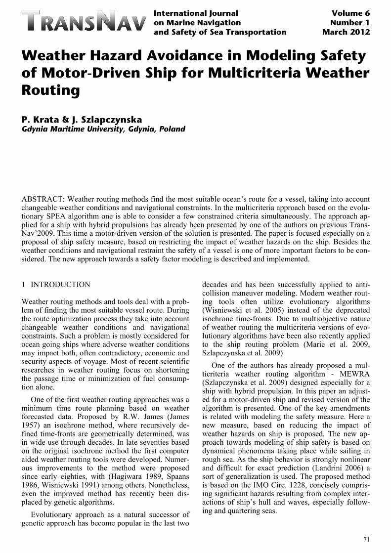
The Multicriteria Weather Routing Algorithm (MEWRA), presented in Figure 1, searches for an optimal route (according to goal functions (1) – (3)) for the assumed ship model. The input data for the algorithm are: − geographical coordinates of route’s origin & des-
tination, − weather forecasts (wind, wave and ice) for con-
sidered ocean area and time period of the voyage being planned.
Figure 1. Multicriteria Evolutionary Weather Routing Algo-rithm (MEWRA)
The algorithm starts with a generation of initial
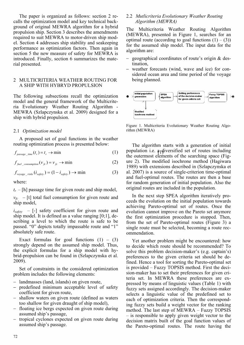
population i.e. a diversified set of routes including the outermost elements of the searching space (Fig-ure 2). The modified isochrone method (Hagiwara 1989) with extensions described in (Szlapczynska et al. 2007) is a source of single-criterion time-optimal and fuel-optimal routes. The routes are then a base for random generation of initial population. Also the original routes are included in the population.
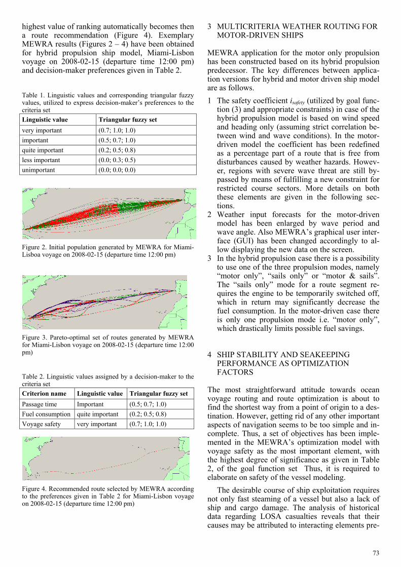
In the next step SPEA algorithm iteratively pro-ceeds the evolution on the initial population towards achieving Pareto-optimal set of routes. Once the evolution cannot improve on the Pareto set anymore the first optimization procedure is stopped. Then, from the set of Pareto-optimal routes (Figure 3) a single route must be selected, becoming a route rec-ommendation.
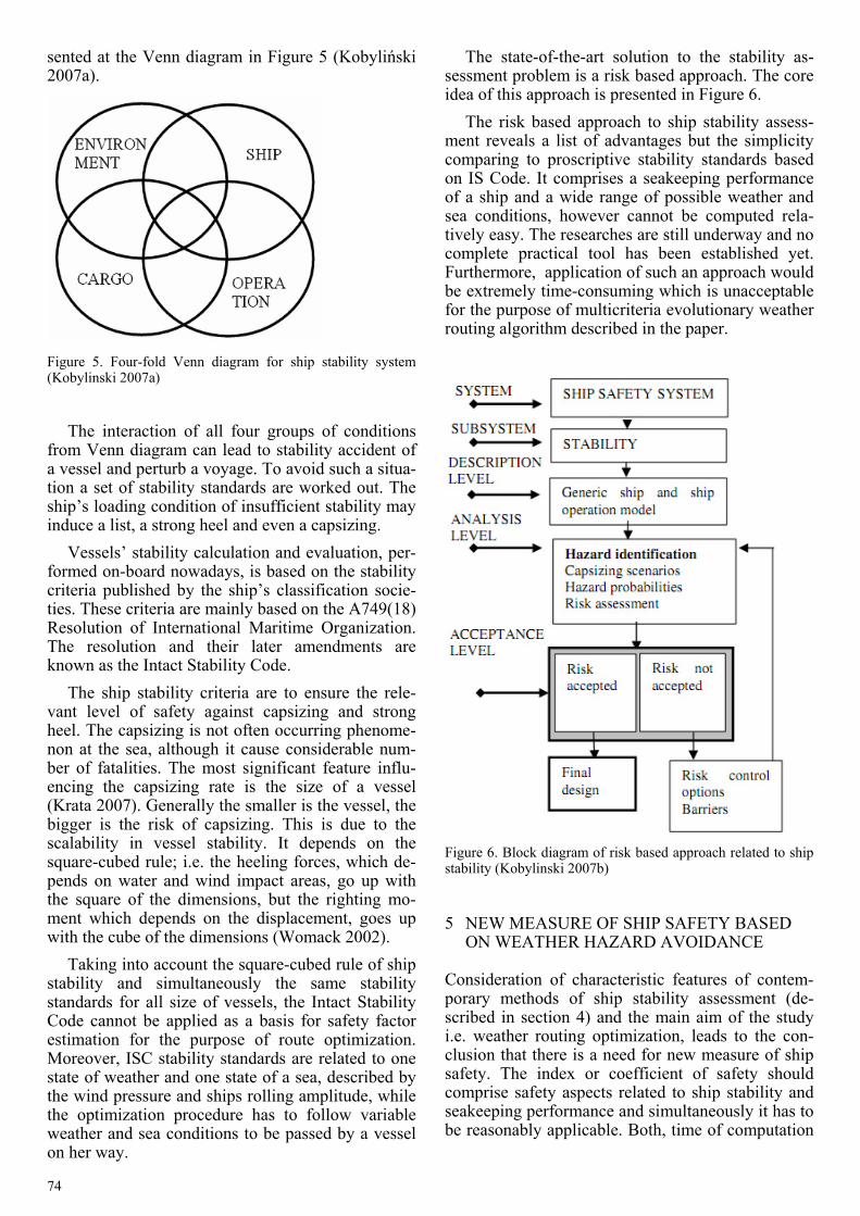
Yet another problem might be encountered: how to decide which route should be recommended? To solve this problem decision-maker’s (e.g. captain’s) preferences to the given criteria set should be de-fined. Hence a tool for sorting the Pareto-optimal set is provided – Fuzzy TOPSIS method. First the deci-sion-maker has to set their preferences for given cri-teria set. In MEWRA these preferences are ex-pressed by means of linguistic values (Table 1) with fuzzy sets assigned accordingly. The decision-maker selects a linguistic value of the predefined set to each of optimization criteria. Then the correspond-ing fuzzy sets build a weight vector for the ranking method. The last step of MEWRA – Fuzzy TOPSIS – is responsible to apply given weight vector to the decision matrix built of the goal function values of the Pareto-optimal routes. The route having the
73
highest value of ranking automatically becomes then a route recommendation (Figure 4). Exemplary MEWRA results (Figures 2 – 4) have been obtained for hybrid propulsion ship model, Miami-Lisbon voyage on 2008-02-15 (departure time 12:00 pm) and decision-maker preferences given in Table 2.
Table 1. Linguistic values and corresponding triangular fuzzy values, utilized to express decision-maker’s preferences to the criteria set Linguistic value Triangular fuzzy set very important (0.7; 1.0; 1.0) important (0.5; 0.7; 1.0) quite important (0.2; 0.5; 0.8) less important (0.0; 0.3; 0.5) unimportant (0.0; 0.0; 0.0)
Figure 2. Initial population generated by MEWRA for Miami-Lisboa voyage on 2008-02-15 (departure time 12:00 pm)
Figure 3. Pareto-optimal set of routes generated by MEWRA for Miami-Lisbon voyage on 2008-02-15 (departure time 12:00 pm)
Table 2. Linguistic values assigned by a decision-maker to the criteria set Criterion name Linguistic value Triangular fuzzy set Passage time Important (0.5; 0.7; 1.0) Fuel consumption quite important (0.2; 0.5; 0.8) Voyage safety very important (0.7; 1.0; 1.0)
Figure 4. Recommended route selected by MEWRA according to the preferences given in Table 2 for Miami-Lisbon voyage on 2008-02-15 (departure time 12:00 pm)
3 MULTICRITERIA WEATHER ROUTING FOR MOTOR-DRIVEN SHIPS
MEWRA application for the motor only propulsion has been constructed based on its hybrid propulsion predecessor. The key differences between applica-tion versions for hybrid and motor driven ship model are as follows. 1 The safety coefficient isafety (utilized by goal func-
tion (3) and appropriate constraints) in case of the hybrid propulsion model is based on wind speed and heading only (assuming strict correlation be-tween wind and wave conditions). In the motor-driven model the coefficient has been redefined as a percentage part of a route that is free from disturbances caused by weather hazards. Howev-er, regions with severe wave threat are still by-passed by means of fulfilling a new constraint for restricted course sectors. More details on both these elements are given in the following sec-tions.
2 Weather input forecasts for the motor-driven model has been enlarged by wave period and wave angle. Also MEWRA’s graphical user inter-face (GUI) has been changed accordingly to al-low displaying the new data on the screen.
3 In the hybrid propulsion case there is a possibility to use one of the three propulsion modes, namely “motor only”, “sails only” or “motor & sails”. The “sails only” mode for a route segment re-quires the engine to be temporarily switched off, which in return may significantly decrease the fuel consumption. In the motor-driven case there is only one propulsion mode i.e. “motor only”, which drastically limits possible fuel savings.
4 SHIP STABILITY AND SEAKEEPING PERFORMANCE AS OPTIMIZATION FACTORS
The most straightforward attitude towards ocean voyage routing and route optimization is about to find the shortest way from a point of origin to a des-tination. However, getting rid of any other important aspects of navigation seems to be too simple and in-complete. Thus, a set of objectives has been imple-mented in the MEWRA’s optimization model with voyage safety as the most important element, with the highest degree of significance as given in Table 2, of the goal function set Thus, it is required to elaborate on safety of the vessel modeling.
The desirable course of ship exploitation requires not only fast steaming of a vessel but also a lack of ship and cargo damage. The analysis of historical data regarding LOSA casualties reveals that their causes may be attributed to interacting elements pre-
74
sented at the Venn diagram in Figure 5 (Kobyliński 2007a).
Figure 5. Four-fold Venn diagram for ship stability system (Kobylinski 2007a)
The interaction of all four groups of conditions
from Venn diagram can lead to stability accident of a vessel and perturb a voyage. To avoid such a situa-tion a set of stability standards are worked out. The ship’s loading condition of insufficient stability may induce a list, a strong heel and even a capsizing.
Vessels’ stability calculation and evaluation, per-formed on-board nowadays, is based on the stability criteria published by the ship’s classification socie-ties. These criteria are mainly based on the A749(18) Resolution of International Maritime Organization. The resolution and their later amendments are known as the Intact Stability Code.
The ship stability criteria are to ensure the rele-vant level of safety against capsizing and strong heel. The capsizing is not often occurring phenome-non at the sea, although it cause considerable num-ber of fatalities. The most significant feature influ-encing the capsizing rate is the size of a vessel (Krata 2007). Generally the smaller is the vessel, the bigger is the risk of capsizing. This is due to the scalability in vessel stability. It depends on the square-cubed rule; i.e. the heeling forces, which de-pends on water and wind impact areas, go up with the square of the dimensions, but the righting mo-ment which depends on the displacement, goes up with the cube of the dimensions (Womack 2002).
Taking into account the square-cubed rule of ship stability and simultaneously the same stability standards for all size of vessels, the Intact Stability Code cannot be applied as a basis for safety factor estimation for the purpose of route optimization. Moreover, ISC stability standards are related to one state of weather and one state of a sea, described by the wind pressure and ships rolling amplitude, while the optimization procedure has to follow variable weather and sea conditions to be passed by a vessel on her way.
The state-of-the-art solution to the stability as-sessment problem is a risk based approach. The core idea of this approach is presented in Figure 6.
The risk based approach to ship stability assess-ment reveals a list of advantages but the simplicity comparing to proscriptive stability standards based on IS Code. It comprises a seakeeping performance of a ship and a wide range of possible weather and sea conditions, however cannot be computed rela-tively easy. The researches are still underway and no complete practical tool has been established yet. Furthermore, application of such an approach would be extremely time-consuming which is unacceptable for the purpose of multicriteria evolutionary weather routing algorithm described in the paper.
Figure 6. Block diagram of risk based approach related to ship stability (Kobylinski 2007b)
5 NEW MEASURE OF SHIP SAFETY BASED ON WEATHER HAZARD AVOIDANCE
Consideration of characteristic features of contem-porary methods of ship stability assessment (de-scribed in section 4) and the main aim of the study i.e. weather routing optimization, leads to the con-clusion that there is a need for new measure of ship safety. The index or coefficient of safety should comprise safety aspects related to ship stability and seakeeping performance and simultaneously it has to be reasonably applicable. Both, time of computation
75
and reliability of computation results need to be con-sidered and balanced.
The limitation of ISC-based approach is its disre-gard of size of a vessel and consideration of only one hydrometeorological conditions. Corresponding-ly the limitation of risk based approach towards ship stability is a lack of fully practical computational tools and a long time of processing. A sort of a trade-off between these two methods may be the new approach based on weather hazard avoidance.
The proposal of a new measure of ship safety or just a method for safety index calculation is derived form the Revised guidance to the master for avoid-ing dangerous situation in adverse weather and sea conditions, published by the International Maritime Organization as MSC Circular 1228. The relatively up to date publication (in comparison to dr. Rahola‘s findings from 1939 being the foundation of IS Code) comprises a set of remarks and advices re-garding avoidance of following dangerous dynam-ical phenomena at sea (IMO 2007): − surf-riding and broaching-to; − reduction of intact ship stability when riding a
wave crest amidships; − synchronous rolling motion; − parametric roll motions.
According to the IMO Circ. 1228 some combina-tions of wave length and wave height under certain operation conditions may lead to dangerous situa-tions for ships complying with the IS Code. As the sensitivity of a ship to dangerous phenomena de-pends on the actual stability parameters, hull geome-try, ship size and ship speed, the vulnerability to dangerous responses, including capsizing, and its probability of occurrence in a particular sea state may differ for each ship (IMO 2007). In addition the wave encounter period and the wave length and height depend on actual hydrometeorological condi-tions. These features are strictly advantageous for the purpose of weather routing applications and as a consequence they are desirable for safety index cal-culation in the course of route optimization.
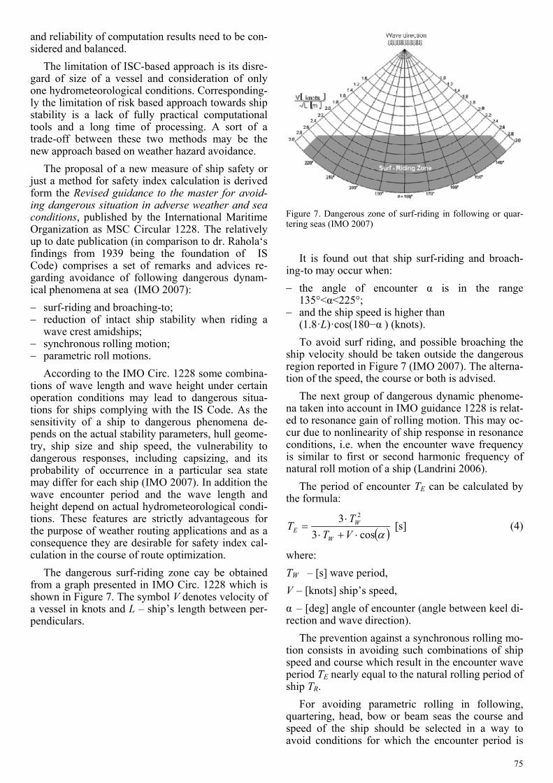
The dangerous surf-riding zone cay be obtained from a graph presented in IMO Circ. 1228 which is shown in Figure 7. The symbol V denotes velocity of a vessel in knots and L – ship’s length between per-pendiculars.
Figure 7. Dangerous zone of surf-riding in following or quar-tering seas (IMO 2007)
It is found out that ship surf-riding and broach-
ing-to may occur when: − the angle of encounter α is in the range
135°<α<225°; − and the ship speed is higher than
(1.8·L)·cos(180−α ) (knots). To avoid surf riding, and possible broaching the
ship velocity should be taken outside the dangerous region reported in Figure 7 (IMO 2007). The alterna-tion of the speed, the course or both is advised.
The next group of dangerous dynamic phenome-na taken into account in IMO guidance 1228 is relat-ed to resonance gain of rolling motion. This may oc-cur due to nonlinearity of ship response in resonance conditions, i.e. when the encounter wave frequency is similar to first or second harmonic frequency of natural roll motion of a ship (Landrini 2006).
The period of encounter TE can be calculated by the formula:
( )αcos33 2
⋅+⋅⋅
=VTT
TW
WE [s] (4)
where: TW – [s] wave period, V – [knots] ship’s speed, α – [deg] angle of encounter (angle between keel di-rection and wave direction).
The prevention against a synchronous rolling mo-tion consists in avoiding such combinations of ship speed and course which result in the encounter wave period TE nearly equal to the natural rolling period of ship TR.
For avoiding parametric rolling in following, quartering, head, bow or beam seas the course and speed of the ship should be selected in a way to avoid conditions for which the encounter period is
76
close to the ship roll period (TE ≈ TR ) or the encoun-ter period is close to one half of the ship roll period (TE ≈ 0,5 TR) (IMO 2007).
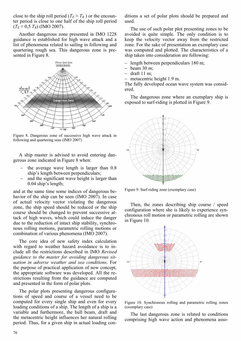
Another dangerous zone presented in IMO 1228 guidance is established for high wave attack and a list of phenomena related to sailing in following and quartering rough sea. This dangerous zone is pre-sented in Figure 8.
Figure 8. Dangerous zone of successive high wave attack in following and quartering seas (IMO 2007)
A ship master is advised to avoid entering dan-
gerous zone indicated in Figure 8 when: − the average wave length is larger than 0.8
ship’s length between perpendiculars; − and the significant wave height is larger than
0.04 ship’s length; and at the same time some indices of dangerous be-havior of the ship can be seen (IMO 2007). In case of actual velocity vector violating the dangerous zone, the ship speed should be reduced or the ship course should be changed to prevent successive at-tack of high waves, which could induce the danger due to the reduction of intact ship stability, synchro-nous rolling motions, parametric rolling motions or combination of various phenomena (IMO 2007).
The core idea of new safety index calculation with regard to weather hazard avoidance is to in-clude all the restrictions described in IMO Revised guidance to the master for avoiding dangerous sit-uation in adverse weather and sea conditions. For the purpose of practical application of new concept, the appropriate software was developed. All the re-strictions resulting from the guidance are computed and presented in the form of polar plots.
The polar plots presenting dangerous configura-tions of speed and course of a vessel need to be computed for every single ship and even for every loading conditions of a ship. The length of a ship is a variable and furthermore, the hull beam, draft and the metacentric height influences her natural rolling period. Thus, for a given ship in actual loading con-
ditions a set of polar plots should be prepared and used.
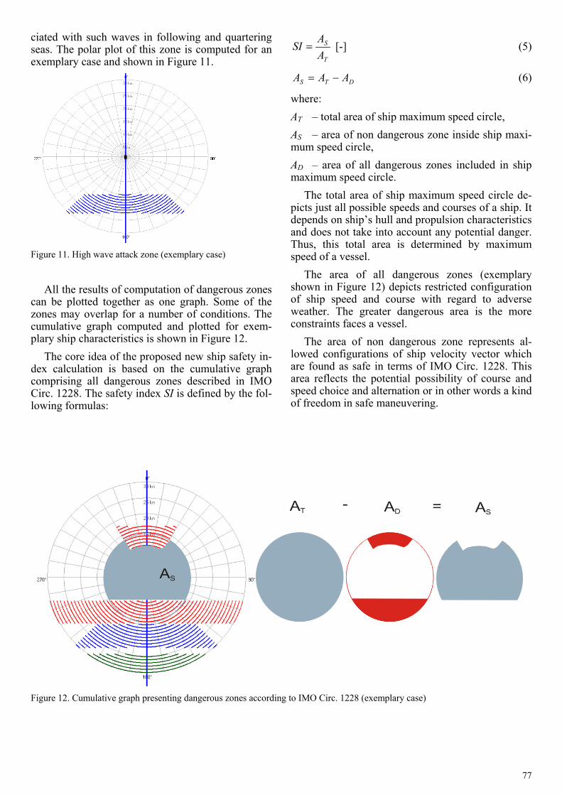
The use of such polar plot presenting zones to be avoided is quite simple. The only condition is to keep the velocity vector away from the restricted zone. For the sake of presentation an exemplary case was computed and plotted. The characteristics of a ship taken into consideration are following: − length between perpendiculars 180 m; − beam 30 m; − draft 11 m; − metacentric height 1.9 m. The fully developed ocean wave system was consid-ered.
The dangerous zone where an exemplary ship is exposed to surf-riding is plotted in Figure 9.
Figure 9. Surf-riding zone (exemplary case)
Then, the zones describing ship course / speed
configuration where she is likely to experience syn-chronous roll motion or parametric rolling are shown in Figure 10.
Figure 10. Synchronous rolling and parametric rolling zones (exemplary case)
The last dangerous zone is related to conditions comprising high wave action and phenomena asso-
77
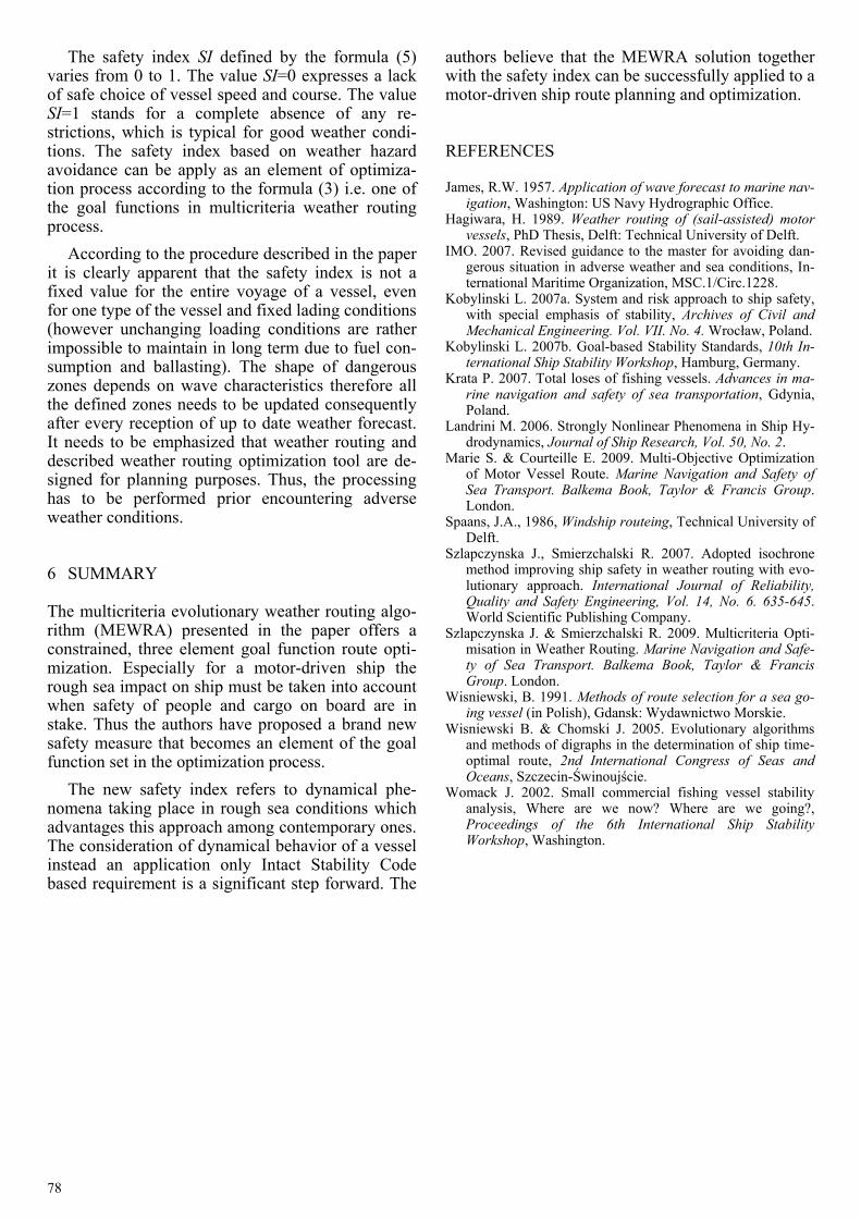
ciated with such waves in following and quartering seas. The polar plot of this zone is computed for an exemplary case and shown in Figure 11.
Figure 11. High wave attack zone (exemplary case)
All the results of computation of dangerous zones
can be plotted together as one graph. Some of the zones may overlap for a number of conditions. The cumulative graph computed and plotted for exem-plary ship characteristics is shown in Figure 12.
The core idea of the proposed new ship safety in-dex calculation is based on the cumulative graph comprising all dangerous zones described in IMO Circ. 1228. The safety index SI is defined by the fol-lowing formulas:
T
S
AA
SI = [-] (5)
DTS AAA −= (6)
where: AT – total area of ship maximum speed circle, AS – area of non dangerous zone inside ship maxi-mum speed circle, AD – area of all dangerous zones included in ship maximum speed circle.
The total area of ship maximum speed circle de-picts just all possible speeds and courses of a ship. It depends on ship’s hull and propulsion characteristics and does not take into account any potential danger. Thus, this total area is determined by maximum speed of a vessel.
The area of all dangerous zones (exemplary shown in Figure 12) depicts restricted configuration of ship speed and course with regard to adverse weather. The greater dangerous area is the more constraints faces a vessel.
The area of non dangerous zone represents al-lowed configurations of ship velocity vector which are found as safe in terms of IMO Circ. 1228. This area reflects the potential possibility of course and speed choice and alternation or in other words a kind of freedom in safe maneuvering.
Figure 12. Cumulative graph presenting dangerous zones according to IMO Circ. 1228 (exemplary case)
78
The safety index SI defined by the formula (5) varies from 0 to 1. The value SI=0 expresses a lack of safe choice of vessel speed and course. The value SI=1 stands for a complete absence of any re-strictions, which is typical for good weather condi-tions. The safety index based on weather hazard avoidance can be apply as an element of optimiza-tion process according to the formula (3) i.e. one of the goal functions in multicriteria weather routing process.
According to the procedure described in the paper it is clearly apparent that the safety index is not a fixed value for the entire voyage of a vessel, even for one type of the vessel and fixed lading conditions (however unchanging loading conditions are rather impossible to maintain in long term due to fuel con-sumption and ballasting). The shape of dangerous zones depends on wave characteristics therefore all the defined zones needs to be updated consequently after every reception of up to date weather forecast. It needs to be emphasized that weather routing and described weather routing optimization tool are de-signed for planning purposes. Thus, the processing has to be performed prior encountering adverse weather conditions.
6 SUMMARY
The multicriteria evolutionary weather routing algo-rithm (MEWRA) presented in the paper offers a constrained, three element goal function route opti-mization. Especially for a motor-driven ship the rough sea impact on ship must be taken into account when safety of people and cargo on board are in stake. Thus the authors have proposed a brand new safety measure that becomes an element of the goal function set in the optimization process.
The new safety index refers to dynamical phe-nomena taking place in rough sea conditions which advantages this approach among contemporary ones. The consideration of dynamical behavior of a vessel instead an application only Intact Stability Code based requirement is a significant step forward. The
authors believe that the MEWRA solution together with the safety index can be successfully applied to a motor-driven ship route planning and optimization.
REFERENCES
James, R.W. 1957. Application of wave forecast to marine nav-igation, Washington: US Navy Hydrographic Office.
Hagiwara, H. 1989. Weather routing of (sail-assisted) motor vessels, PhD Thesis, Delft: Technical University of Delft.
IMO. 2007. Revised guidance to the master for avoiding dan-gerous situation in adverse weather and sea conditions, In-ternational Maritime Organization, MSC.1/Circ.1228.
Kobylinski L. 2007a. System and risk approach to ship safety, with special emphasis of stability, Archives of Civil and Mechanical Engineering. Vol. VII. No. 4. Wrocław, Poland.
Kobylinski L. 2007b. Goal-based Stability Standards, 10th In-ternational Ship Stability Workshop, Hamburg, Germany.
Krata P. 2007. Total loses of fishing vessels. Advances in ma-rine navigation and safety of sea transportation, Gdynia, Poland.
Landrini M. 2006. Strongly Nonlinear Phenomena in Ship Hy-drodynamics, Journal of Ship Research, Vol. 50, No. 2.
Marie S. & Courteille E. 2009. Multi-Objective Optimization of Motor Vessel Route. Marine Navigation and Safety of Sea Transport. Balkema Book, Taylor & Francis Group. London.
Spaans, J.A., 1986, Windship routeing, Technical University of Delft.
Szlapczynska J., Smierzchalski R. 2007. Adopted isochrone method improving ship safety in weather routing with evo-lutionary approach. International Journal of Reliability, Quality and Safety Engineering, Vol. 14, No. 6. 635-645. World Scientific Publishing Company.
Szlapczynska J. & Smierzchalski R. 2009. Multicriteria Opti-misation in Weather Routing. Marine Navigation and Safe-ty of Sea Transport. Balkema Book, Taylor & Francis Group. London.
Wisniewski, B. 1991. Methods of route selection for a sea go-ing vessel (in Polish), Gdansk: Wydawnictwo Morskie.
Wisniewski B. & Chomski J. 2005. Evolutionary algorithms and methods of digraphs in the determination of ship time-optimal route, 2nd International Congress of Seas and Oceans, Szczecin-Świnoujście.
Womack J. 2002. Small commercial fishing vessel stability analysis, Where are we now? Where are we going?, Proceedings of the 6th International Ship Stability Workshop, Washington.