web 2.0 broker: a standards-based service for spatio-temporal
TRANSCRIPT

at SciVerse ScienceDirect
Applied Geography 35 (2012) 448e459
Contents lists available
Applied Geography
journal homepage: www.elsevier .com/locate/apgeog
Web 2.0 Broker: A standards-based service for spatio-temporal searchof crowd-sourced information
Laura Díaz a,*, Carlos Granell b,1, Joaquín Huerta a,2, Michael Gould a,3
aUniversity Jaume I, Institute of New Imaging Technologies, Av. Sos Baynat s/n, 12006 Castellón, Spainb European Commission, Joint Research Centre, Institute for Environment and Sustainability, Via E. Fermi 2749, I-21027 Ispra (VA), Italy
Keywords:Spatio-temporal searchCrowd-sourced dataOpenSearchWeb 2.0 BrokerWeb 2.0 services
* Corresponding author. Tel.: þ34 964 729 078; faxE-mail addresses: [email protected] (L. Díaz), c
(C. Granell), [email protected] (J. Huerta), [email protected] (M1 Tel.: þ39 0332 78 5758; fax: þ39 0332 78 6325.2 Tel.: þ34 964 728 319; fax: þ34 964 728 435.3 Tel.: þ34 964 728 317; fax: þ34 964 728 435.
0143-6228/$ e see front matter � 2012 Elsevier Ltd.http://dx.doi.org/10.1016/j.apgeog.2012.09.008
a b s t r a c t
Recent trends in information technology show that citizens are increasingly willing to share informationusing tools provided by Web 2.0 and crowdsourcing platforms to describe events that may have socialimpact. This is fuelled by the proliferation of location-aware devices such as smartphones and tablets;users are able to share information in these crowdsourcing platforms directly from the field at real time,augmenting this information with its location. Afterwards, to retrieve this information, users mustdeal with the different search mechanisms provided by the each Web 2.0 services. This paper exploreshow to improve on the interoperability of Web 2.0 services by providing a single service as a uniqueentry to search over several Web 2.0 services in a single step. This paper demonstrates the usefulness ofthe Open Geospatial Consortium’s OpenSearch Geospatial and Time specification as an interface fora service that searches and retrieves information available in crowdsourcing services. We presenthow this information is valuable in complementing other authoritative information by providing analternative, contemporary source. We demonstrate the intrinsic interoperability of the system showingthe integration of crowd-sourced data in different scenarios.
� 2012 Elsevier Ltd. All rights reserved.
Introduction
Geospatial Information Infrastructures (GIIs), also known asgeospatial cyberinfrastructures (Yang, Raskin,Goodchild, &Gahegan,2010) and Spatial Data Infrastructures (SDIs; Masser, 2005), haveprovided scientists andpublic sector organizationswith instrumentsfor organizing, sharing, access and exploiting the large amount ofgeospatial content for earth sciences decision-making. GIIs consist ofa network of distributed nodes based on well-defined architecturalstyles and standards specifications. A given GII publicly exposes a setof geospatial web services, according to principles of ServiceOriented Architectures (SOA), to allow software clients to discovery,access and retrieve geospatial data from them. To increase interop-erability, the Open Geospatial Consortium (OGC) has promoted thecreation of consensus specifications for data encodings and serviceinterfaces to standardize communication protocols between theseclients and services.
: þ34 964 728 [email protected]. Gould).
All rights reserved.
In parallel to the evolution of GIIs, we are witnessing theconsolidation of a new generation of social networks and Web 2.0services, which are characterized by greater levels of user partici-pation and ease of content sharing. The Web is now a collaborativeenvironment that has turned users into active providers (Coleman,Georgiadou, Labonte, 2009) capable of generatingmassive amountsof new content. This user-generated content often is georeferencedaccording to a user’s location at the time of data capture. Thismeans that a large amount of georeferenced user-generatedcontent is increasingly available in a wide variety of topics.
A clear dichotomy has emerged between top-down and bottom-up approaches to georeferenced data collection and sharing. On onehand, GIIs rely on top-down methodologies, constrained by stan-dards but which do not consider the participation of citizensoutside the official system of creation and publication of authori-tative geospatial data, collected and validated only by officialinstitutions and mapping agencies. Moreover, the lack of assistedtools for data publication (Díaz, Granell, Gould, & Huerta, 2011)combined with the resource-demanding and time-consuming taskof continuously updating these datasets (Zlatanova et al., 2009)have set real barriers in efficiently exploiting authoritative geo-spatial data. On the other hand, social networks are eminently user-centric and follow bottom-up methodologies whereby users arefree to produce and share their data using a diversity of aggregation

Fig. 1. The conceptual brokering approach.
4 https://twitter.com/.
L. Díaz et al. / Applied Geography 35 (2012) 448e459 449
and broadcast technologies that become de facto standards at best.These data are in many cases more timely and, therefore, moreuseful during emergencies and time-critical scenarios (Goodchild,2007). The diversity of solutions extends to service providers interms of different publication capabilities and variability of appli-cation programming interfaces (APIs) offered by each Web 2.0service. This makes ad hoc data access and retrieval difficult forclient applications because, as opposed to GIIs, standard serviceinterfaces and data encodings are not commonly followed.
The integration and interrelation of user-generated data withauthoritative geospatial datasets may potentially bring together thebest of both worlds for decision-making in many real-worldscenarios such as the assessment of environmental issues (Granell,Díaz, & Gould, 2010). In this context, however, to assess the abovehypothesis we need suitable mechanisms to seamlessly search andretrieve datasets from both worlds. Our ultimate goal is then toimprove the interoperability among the available heterogeneousWeb 2.0 services, so that distinct application scenarios can benefitfrom the integration of these search results and official datasets. Tothat end this paper addresses the following research questions:
� How can we retrieve user-generated content based on spatio-temporal criteria from multiple crowd-sourcing services?
� Under which circumstances can the integration of authorita-tive and non-authoritative data be valuable in scenariosbeyond the mere visualization of these datasets such as foranalysis and decision-making activities?
We propose an integrated, scalable software brokering solutionbased on standard specifications and well-defined software engi-neering patterns. We present a middleware component thatmediates between client applications and backendWeb 2.0 servicesand social networks. This component, called the Web 2.0 Broker(W2B), is implemented as a web service providing a single searchand retrieval interface based on the OGC OpenSearch Geo-Timespecification (Gonçalves, 2010). The component has been shownto improve interoperability in the discovery and retrieval of infor-mation across different crowd-sourcing services.
The remainder of this paper is structured as follows: Section 2defines the foundations of this work. Section 3 highlights themost important aspect of the Web 2.0 Broker from a technologicalpoint of view. Section 4 introduces the reference architecture tomake possible the integration of our solution in the proposedsystems and the description of a set of scenarios. Section 5 presentsa discussion on the described work. Section 6 ends the paper withsome conclusions.
Foundations
This section describes in detail the foundational pillars onwhichthe Web 2.0 Broker service rests.
Crowd-sourcing services: bottom-up approach
Due to the easiness to use data-creation tools available as Web2.0 services, millions of users have become data producers. At thecore of the Web 2.0 vision, simplicity allows users to produce andshare their own data through “one-click” services. User-generatedcontent is multidisciplinary and heterogeneous, making it aninvaluable source of social data to be used by scientific and businesscommunities. Nevertheless, at the same time, there is still a needfor adequate tools for data search and retrieval (Munro, 2012).
An additional factor on the shift in the role of users and theexponential proliferation of user-generated data is the massiveadoption of mobile devices. The inherent simplicity of sensor-
enabled mobile devices to be “data-capturing tools” has turnedusers into real-time and ubiquitous creators of any kind of mediacontent (e.g. text, videos, audio files, pictures). As such user-generated content refers to phenomena that are bound to a loca-tion, such a georeferenced content is acquiring a fundamental rolein a wide range of applications. For example simple georeferencedmessages from social networks such as Twitter4 may play a majorrole in response actions to emergencies (Roche, Propeck-Zimmermann, Mericskay, 2012; Schade et al., 2012). Even whendifferent types of data are combined, for example point of interestsand pictures, new scenarios come out such as volunteeredebasedmap creation (Neis, Zielstra & Zipf, 2012), and the collection of insitu biodiversity data (Newell, Pembroke & Boyd, 2012) and forestrydata (Aragó, Tamayo, Viciano, Huerta & Díaz, 2011). This phenom-enon has been tagged with different labels such as Neogeography(Turner, 2006), Cybercartography (Tulloch, 2007), and VolunteeredGeographic Information (VGI) (Goodchild, 2007), being VGI themost widely accepted term in the geospatial community.
Although VGI data still represents a small percentage, its growthis being greatly accelerated largely by the expansion of sensor-enabled devices. It is thus reasonable to foresee that huge amountsof georeferenced data will be available in an immediate future. Thisposes the questionwhether VGImay be seen as an alternative sourceof information to complement authoritative data from GIIs (Cragliaet al., 2008), so as to improve traditional geospatial analysis anddecision support tasks (Flanagin & Metzger, 2008; Pultar, Raubal,Cova & Goodchild, 2009) since it provides data at high spatiotemporal scales (Zook, Graham, Shelton, & Gorman, 2010). Expertsand decision makers may even benefit from VGI data in multipleanalysis situations suchas epidemiology (Aanensen,Huntley, Feil, al-Own & Spratt, 2009) and geo-demographics (Singleton & Longley,2009). In these cases the bottom-up approach exemplified bycrowd-sourcing services may complement the top-down method-ologies that articulate GIIs. In this paper we explore a mechanism toenhance the search and retrieval of data from crowd-sourcingservices to be integrated among others in the GII context.
Geospatial information infrastructures: top-down approach
GIIs or SDIs, offer the capability of discovering, accessing andsharing a diversity of geospatial resources via standards webservices among a wide range of actors at different scales (Masser,Rajabifard & Williamson, 2007; Rajabifard, Feeney & Williamson,2002). They comprise a set of policies and standard activitiespromoting the creation of geospatial information services to assist
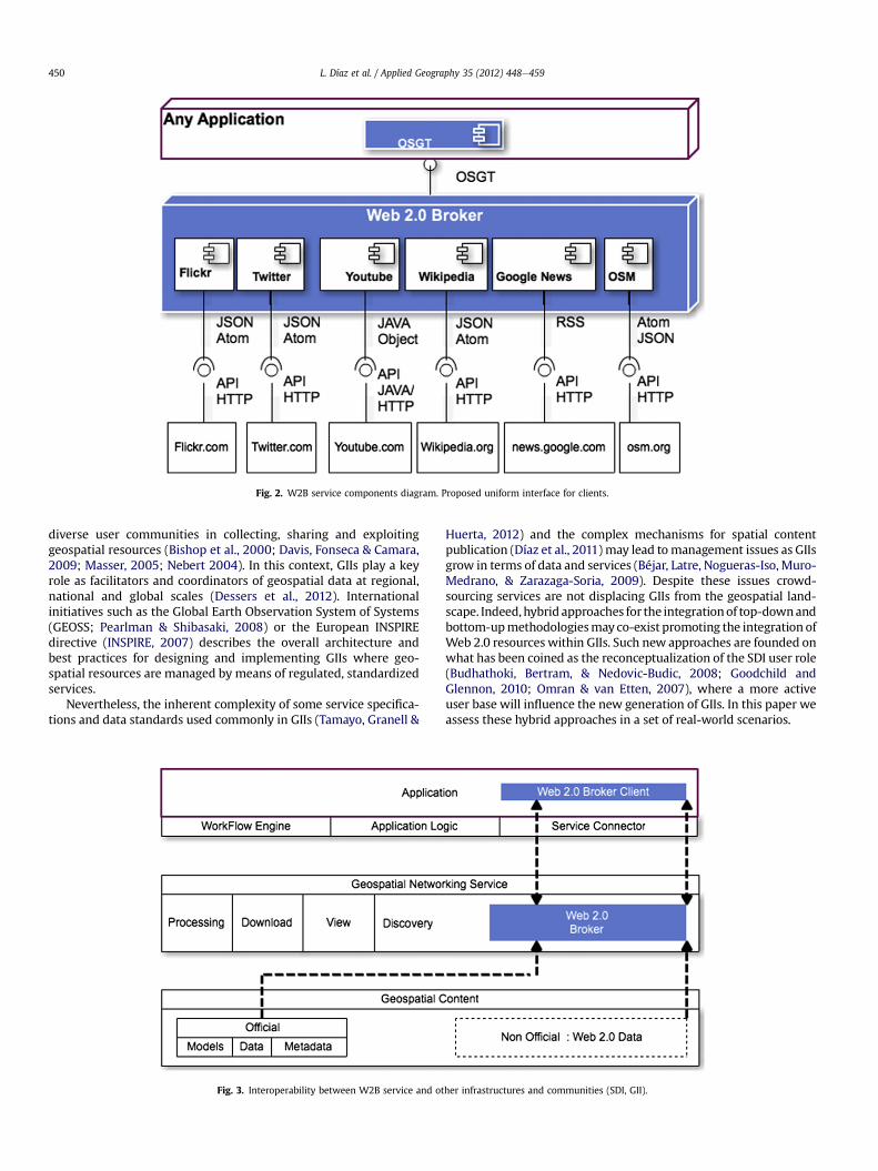
Fig. 2. W2B service components diagram. Proposed uniform interface for clients.
L. Díaz et al. / Applied Geography 35 (2012) 448e459450
diverse user communities in collecting, sharing and exploitinggeospatial resources (Bishop et al., 2000; Davis, Fonseca & Camara,2009; Masser, 2005; Nebert 2004). In this context, GIIs play a keyrole as facilitators and coordinators of geospatial data at regional,national and global scales (Dessers et al., 2012). Internationalinitiatives such as the Global Earth Observation System of Systems(GEOSS; Pearlman & Shibasaki, 2008) or the European INSPIREdirective (INSPIRE, 2007) describes the overall architecture andbest practices for designing and implementing GIIs where geo-spatial resources are managed by means of regulated, standardizedservices.
Nevertheless, the inherent complexity of some service specifica-tions and data standards used commonly in GIIs (Tamayo, Granell &
Fig. 3. Interoperability between W2B service and ot
Huerta, 2012) and the complex mechanisms for spatial contentpublication (Díaz et al., 2011) may lead tomanagement issues as GIIsgrow in terms of data and services (Béjar, Latre, Nogueras-Iso, Muro-Medrano, & Zarazaga-Soria, 2009). Despite these issues crowd-sourcing services are not displacing GIIs from the geospatial land-scape. Indeed,hybrid approaches for the integrationof top-downandbottom-upmethodologiesmay co-exist promoting the integration ofWeb 2.0 resources within GIIs. Such new approaches are founded onwhat has been coined as the reconceptualization of the SDI user role(Budhathoki, Bertram, & Nedovic-Budic, 2008; Goodchild andGlennon, 2010; Omran & van Etten, 2007), where a more activeuser base will influence the new generation of GIIs. In this paper weassess these hybrid approaches in a set of real-world scenarios.
her infrastructures and communities (SDI, GII).

Fig. 4. Reference architecture.
6 http://www.opensearch.org/Specifications/OpenSearch/Extensions.
L. Díaz et al. / Applied Geography 35 (2012) 448e459 451
A technological look inside W2B service
As seen above, GIIs and crowd-sourcing services follow differentapproaches but essentially pursue same objectives: facilitators ofdata. In order to explore the first research question mentionedearlier e the interplay of non-authoritative and authoritative datae we have developed the W2B service that enables to seamlesslysearch and retrieve datasets from both worlds. This section thusgives a brief summary of the main technological drivers that definethe W2B service so that it can be an integral part of the scenariosdescribed in Section 4. Díaz et al. (2012) complement this sectionfrom a technical perspective providing a deep discussion on theconceptual architecture and implementation details.
Brokering approach
Web 2.0 services provide public APIs to client applications tointeract with them via specific encodings and methods. Althougha few data formats are gaining popularity and wide acceptance (e.g.JSON), there is no standard consensus on the description of serviceinterfaces and data encodings used. This situation clearly raisesa technical barrier for discovering user generated content frommultiple crowdsourcing platforms in a uniform manner, becauseservice clients need to understand specific data formats andimplement diverse APIs to be able to access and retrieve data fromvarious Web 2.0 services. This issue has been long studied from theperspective of software engineering. Buschmann, Meunier,Rohnert, Sommerland and Stal (1996) proposed the architecturalpattern Broker that may be easily understood as a middlewarecomponent connecting heterogeneous components and systems toimprove scalability and interoperability.
The main goal of the W2B service is to facilitate the access andretrieval of data from diverse Web 2.0 services. Here, the brokerpattern meets our requirements. Indeed, the W2B service followsa brokering approach (Nativi, Craglia, Vaccari & Santoro, 2011),which extends the basic broker pattern by transferring the requiredbusiness logic such as coordinating requests and responses andhandling with specific standards for data encoding to a brokeringmiddleware. As Fig. 1 illustrated, a broker allows clients to connectwith multiple services that follow their own syntax for requestingand delivering data. This is the case of theW20 service that enablessmooth data discovery and access through a great variety ofdifferent APIs published by Web 2.0 services and platforms. Thisway theW2B service exposes one single interface (see next section)and makes it possible to transform a single user request intomultiple, API-based requests addressed to varied Web 2.0 services.
Spatio-temporal search and retrieval
The OpenSearch (OS) specification5 defines a set of searchparameters and a communication protocol. For a client application,an OS-enabled service exposes a search interface based on HTTP
5 http://www.opensearch.org.
GET requests with specific query parameters according to thespecification. These parameters such as query term must bedescribed using an OS Description Document file which is availableto enable clients to build proper queries.
The OS specification can be extended for particular purposesand functionalities.6 One of these extensions is the OpenSearchGeospatial and Time specification (OSGT) (Gonçalves, 2010),recently adopted by the Open Geospatial Consortium (OGC) asa standard specification. In short, OSGT extends the base OS spec-ification with parameters to support spatio-temporal discovery.User can specify a place name, area, point and radius, and a timeperiod as part of a spatio-temporal query (Díaz et al., 2012). TheW2B service has adopted the OSGT interface to provide a singleinterface from the client perspective (See Fig. 2, top). This way,regardless of the nature of the backendWeb 2.0 services supportedby the W2B service, potential clients only need to understanda single search interface.
Client applications build valid search queries by consulting theOSDescription Document file. Once received a query, the W2B servicetransforms it into specific queries (according to each particular API’sencodings and methods) by means of the specialized components(e.g. Flickr, YouTube, etc. in Fig. 2), and broadcasts them to therequested Web 2.0 services. In the response phase, the resultsencoding format must be known to client applications. Fig. 2(bottom) shows the array of Web 2.0 services mediated by the W2Band their interfaces and encoding formats. Although searchresponses are often encoded in lightweight data formats such asRSS,7 Atom8 and JSON9 theOS specification in reality doesnot imposeany particular response format. The W2B service transforms encod-ing formats used by the target Web 2.0 services into a middlewareencoding format. From our experiments, we suggest that candidateencoding formats should at least support two basic constraints: theymust support links and spatio-temporal features. Links are meant toprovide direct access to actual data that client applications areseeking for. The latter condition refers tonatively support and encodespatial and temporal information. To this respect the W2B servicesupports Atom and KML among others (Díaz et al., 2012).
Interoperability and compatibility
As earlier commented one of the key mechanisms to enablegeospatial data sharing is the establishment of GIIs. Current trendsin multilevel GII development enable end-users to share spatialdata in decentralized structures where a top-down structure aimsto achieve interoperability while the bottom-up structure aims tointegrate user knowledge. When we talk about interoperabilitybetween two distinct services, we mean that they can successfullyinteract with each other. Take for example Twitter and Open StreetMap services that do not interoperate a priori yet need to co-
7 http://www.rssboard.org/rss-specification/.8 http://tools.ietf.org/html/rfc4287.9 http://www.json.org/.

Fig. 5. EuroGEOSS discovery broker integration architecture.
10 http://www.eurogeoss.eu.
L. Díaz et al. / Applied Geography 35 (2012) 448e459452
operate jointly in our scenario, permitting then users to search forgeospatial data seamlessly from multiple Web 2.0 and crowd-sourcing services.
Fig. 3 shows a 3-tier architecture for GIIs where we can see howthe W2B service and client applications are deployed. Any clientapplication (as theWeb 2.0 Broker client in the figure) that requiresinteracting with the W2B service will simply access to this service(see discontinuous line) as if it were any other standards-basedgeospatial services available in GIIs (see middleware layer in thefigure), since the W2B service is regarded as a type of discoveryservice (Fig. 3). From themiddleware layer theW2B service accessesthe content layer for retrievingboth official and crowd-sourceddata.
Two determining factors are required to support the neededinteroperability in the scenario described in the early paragraph.First, the W2B service increases the interoperability between geo-spatial users and theWeb 2.0 services, since the brokering approachis flexible enough to make the access transparent to heterogeneoussources, capabilities and interfaces offered by the backend Web 2.0services. Second, the W2B service promotes compatibility withexisting standards and data formats already in use in current GIIs. Inthis sense, the W20 is able to integrate user generated data andofficial datasets in middleware formats (Section 3.2). This waysearch results through the W2B service can be easily consumed bytraditional GII clients (e.g. map viewers, desktop applications). Notonly is the ability to access and retrieve data fromWeb 2.0 servicesrelevant in our case, but also important is to promote collaborationand integration with existing geospatial components and infra-structures to avoid isolated silos, so that the geospatial communitymay benefit from new synergies and integrated developments(Kates et al., 2001; Reid et al., 2010). That is, theW2B service acts asdata discovery services available commonly inGIIs (Fig. 3). For doingso, the W2B service has been designed to be an easy-to-deployservice, which can be reusable in different environments andmaximize thus its use in varied scenarios.
Flexible deployments
In a system, interoperability and reusability trend to correlatepositively. This means that improvements in interoperability followgreater levels of reusability.However, someadditional efforts have tobe made to enhance reusability. Accordingly, the W2B service ach-ieves interoperability by adopting the brokering approach (Section3.1). As regards reusability, theW2B service is designed as a standardweb service, which makes it suitable to be smoothly deployed inservice-oriented architectures such as GIIs (see Fig. 3). Thanks to thesimplicity of theOSGT interface, different kinds of client applicationscan easily integrate a tiny OSGT-compliant component (see Section3.2), which is able to access and interact with theW2B service. Fig. 4illustrates the reference architecture that can be used to instantiatespecific architectures when deploying the W2B in GIIs.
In the next section we describe extensions of the referencearchitecturewhich have been implemented, deployed and tested invaried scenarios. These extensions range from aggregating theW2Bservicewith other brokers to the integration of tinyOSGT-compliantcomponents into existing web applications. These scenariosdemonstrate the key technological drivers and illustrate the value ofthe W2B service.
Scenarios with W2B service
The W2B service has been designed as an interoperable serviceimplementing a standard interface to be re-used in differentscenarios. To demonstrate the potential value of crowd-sourcedinformation beyond the mere visualization on maps, in this sectionwe describe how the W2B service has been deployed in a widevariety of scenarios. Section 5, however, discusses the applicability ofcrowd-sourced information, i.e. the outputof ourW2B service, in thecontext of these application scenarios.
Support for GEOSS components
One success story of the brokering approach mentioned earlier(Section 3.1) is the EuroGEOSS Discovery Broker (Nativi et al., 2011),an outcome of the European project EuroGEOSS10 and an overallcontribution toGEOSS (Global EarthObservation Systemof Systems)and its Common GEOSS Infrastructure (CGI) (Nativi, Craglia &Pearlman, 2012). The EuroGEOSS Discovery Broker providesa unique access point to services and data sources from three GEOSSsocietal benefit areas: biodiversity, forestry, and drought.
TheW2B is also a result from the EuroGEOSS project and followsthe same brokering approach. However, rather than focussing ondata sources provided and published in GIIs and other authoritativesources, as the EuroGEOSSDiscovery Broker does, theW2B service isdesigned to interact with crowd-sourcing platforms in which thespatio-temporal dimension is or may be relevant (Díaz et al., 2012).In this way the W2B service augments the functionality of theEuroGEOSS Discovery Broker with concepts emerging in the Web2.0 communities with respect to user interactions and Web 2.0resource discovery.
The scenario described here highlights the advantage of aggre-gatingvariousbrokers towork cooperatively toprovide an integratedfunctionality that augments that of any single broker (Vaccari,Craglia, Fugazza, Nativi, & Santoro, 2012). Fig. 5 shows an extensionto the reference architecture (Fig. 4), that integrates theW2B serviceinto the EuroGEOSSDiscoveryBroker. TheOSGTAccessor componentin Fig. 5 is functionally identical to theOSGT-compliant component inthe left part of Fig. 4. Both act as clients to interact with the W2B

Fig. 6. Screenshot of W2B integration into EuroGEOSS brokering platform.
L. Díaz et al. / Applied Geography 35 (2012) 448e459 453
service. In the case of the aggregated EuroGEOSSDiscovery Broker inFig. 5, theDiscoveryBroker is aimed to search forauthoritative, cross-thematic data (bottom part of Fig. 5), where the aim of the W2Bservice is to retrieve multidisciplinary user-generated data. Furtherdetails on implementation and service interfaces required to aggre-gate both brokers are described in Díaz et al. (2012).
Fig. 6 depicts a screenshot of a web client interacting with theEuroGEOSS Discovery Broker to retrieve Web 2.0 data from sourcessuch as Flickr. In this scenario, the W2B emphasizes some of thetechnology drivers described in Section 3, especially the brokeringapproach (Section 3.1). The W2B service may be aggregated withother brokers to build on-demand brokering solutions while at thesame time maintaining a simple service interface from the clientperspective. That is, business logic is transferred to the brokercomponents rather than to the client application.
Support for environmental monitoring applications
Aswehave seen in the previous example, following the referencearchitecture in Fig. 4, the W2B service can be aggregated into otherbrokers. Nextwe showhow theW2B service canwork in isolation tobe accessed by operational environmental monitoring applications,in this case the European Forest Fire Information System (EFFIS)(McInerney et al., 2012) and the Habitat Assessment and EcologicalForecasting system (Dubois et al., 2011), both developed and hostedby the Institute of Environment and Sustainability (IES) at the JointResearch Centre (JRC). In both cases, a small OGCT-client componenthas been developed and integrated in these client applications.
The EFFIS11 provides users with data and tools to monitor forestfires in Europe on a daily basis. Among others, EFFIS providesspecific models and services to help experts monitor the spatialdistribution of forest fires in order to evaluate fire damage as well asenvironmental (forestry resource, biodiversity loss and drought
11 http://effis.jrc.ec.europa.eu.
influences) and social impacts (McInerney et al., 2012). During themonitoring of a fire event, crowd-sourced information retrievedfromWeb 2.0 services may offer a more timely yet complementaryview to the authoritative data (Curtis and Mills, 2012; Díaz et al.,2012). In this direction we have shown the practical use of theW2B service by using it from the EFFIS front-end application toallow EFFIS users to contrast or support official information byretrieving related information from crowd-sourcing platforms. Theresulting architecture in Fig. 7 extends the reference architectureshown in Fig. 4 by including an OSGT-complaint client that allowskeyword and area search from diverse crowdsourcing services.
A second scenario is concerned with environmental monitoringapplications for assessment and forecasting of biodiversity habitats atworldwide scale: the e-Habitat12 web application. This application isdesigned for locating and assessing ecosystems with similar environ-mental properties (Dubois et al., 2011). Like in the case of EFFIS, the e-Habitat technicians implemented the samesolution illustrated in Fig. 7.
Fig. 8 shows the resulting e-Habitat client application that isable to interact with the W2B service to retrieve information aboutan avian species “Circus Maurus” in South Africa. In this scenario,the implementation of the OSGT-compliant client has amore or lessfixed set of parameters such as the search term fixed to scientificspecies name. For instance, users can select the “Bird” region on theright hand side and search for a species by its scientific name (e.g.“Circus Maurus”) from a dropdown list. The user is shown yellowsquares indicating the regional results.
Support for ad-hoc applications
In the context of the EuroGEOSS project we developed an ad-hocapplication called EuroGEOSS Web 2.0 client13 to interact with theW2B service. Thanks to the simplicity of the access interface, the
12 http://ehabitat.jrc.ec.europa.eu/content/web-services.13 It is currently available to the public at http://elcano.dlsi.uji.es/GF/.

Fig. 7. EFFIS Web 2.0 Broker integration architecture.
L. Díaz et al. / Applied Geography 35 (2012) 448e459454
creation of ad-hoc client applications that exploit the potential ofthe W2B service may be a straightforward, alternative solutionwhen the integration of such a client functionality is not possible inexisting applications due for instance to software policy restrictions.
In the following scenario the EuroGEOSS Web 2.0 client isintended tomonitor the status of a detected fire. The client providesa web map to visualize data coming from various sources. Addi-tionally, it shows the burned areas retrieved from the EFFIS dataservices, which allow users to overlap and study official and crowd-sourced data reported in most cases by citizens affected by thedisaster. This web client offers simple and advanced interfaces(customizable by the user) to specify search criteria and builda query. Users can add spatio-temporal criteria by selecting the areaof interest in the form of a rectangle on the map or by providingpoint and radius information. Additionally, users looking for resultswithin a certain time period may specify begin and end dates.
Next two examples show forest fires in Spain in different regionsand periods of time. The first forest fire event occurred in Mijas(Málaga) in 2011. For this example, we performed queries restrictedto the area ofMijas and time of the event. Fig. 9 showsgeoreferencedpictures taken by citizens who were near the fire event when ithappened. In the figure one observes the added value of mixingauthoritative and non-authoritative data. For instance, the convexhull of thepictures providedby the citizens closelyapproximates theofficial burned area provided by EFFIS. Here in the absence of officialburn area the citizen data gives a worthy estimate. In addition, thecrowdsourced data is available in near-real time, meaning that inmost cases this informationwill be useful for time-critical decisionsand potentially saving more human lives when responders act onthis data immediately rather than waiting for official sources.
The second example refers to recent severe forest fires (as ofJune 2012) in the Valencia region (east coast of Spain), wherealmost 50,000 ha were burned. In Fig. 10 we see the burned areasreported by EFFIS and user-generated data published during thefire period. We can see fire-fighting labours being reported,pictures and videos reporting the status of the towns nearbycompletely covered with ash, and complaints and proposals bycitizens living in the areas to avoid similar disasters in the future.
Event monitoring during the forest fire in a real world scenariodemonstrates the use of the W2B service, where users are able touse both volunteered contributions through Web 2.0 services inaddition to official environmental-related data. As we discuss inSection 5, these examples show how W2B make it easy to retrievecitizen contributions, which is not a substitute for scientific data buta complementary source of information that may assist decisionmakers in multidisciplinary monitoring scenarios such as in thecase of natural disasters and hazards such aswildfires or hurricanes.
Apart from web-based applications we have also developeda mobile application to show the wide range of clients that caninteract with the W20 service. Fig. 11 illustrates a screenshot of aniOS14 application that connects to the W2B and shows user
14 Apple’s operation system for mobile devices such as iPhone, http://www.apple.com/ios/.
generated data regarding requested terms. This application hasbeen designed to contain a base map (this case showing the topo-graphic map served by ESRI15) and a module to translate userqueries to OSGT and connect to the W2B, as the web-based clientapplications mentioned earlier do. Fig. 11, shows the results refer-ring to recent forest fires (as of September 2012) in themunicipalityof Chulilla16 again in the Valencia region; we can appreciate user-generated data reporting the event in the form of text messagespublished in Twitter, photographs retrieved from Flicker and videocapturing the situation available in YouTube.
Support for VGI applications
In the context of environmental monitoring there are alsovolunteerebased applications. This is the case of Geo-wiki, a globalnetwork of volunteers aiming to improve the quality of differentthematic datasets, with strong focus on land use (Fritz et al., 2009;Fritz et al., 2012). The Geo-wiki application shows authoritativedata layers such as CORINE Land cover to be validated by users whohave a great knowledge of their local surroundings and can validatesuch datasets. In this way the W2B service can search for relatedinformation published in crowdsourcing platforms to support theuser who validates or ground-truths a specific area. Following thesame principles the W2B service integration is implemented withthe same architecture shown in Fig. 7. The Geo-wiki techniciansintegrated a simplistic OSGT client to allow users to visualize termsretrieved by a default query.
Fig. 12 shows results obtained from the W2B service integratedinto the geo-wiki project. In this example the volunteeredgeographic information extracted from Web 2.0 services is relatedto Flickr content tagged as “nature” in Thailand (Schill et al., 2012).Note that in all these examples any publically accessible base mapmay be used; W2B is agnostic to that layer.
Support for Digital Earth applications
The vision of Digital Earth is widely regarded as a key milestonefor the geospatial community (Craglia et al., 2008; Craglia et al.,2012; Goodchild et al., 2012). The digital replica or model of theentire planet as a virtual globe is gaining acceptance mostly withinthe scientific community. Recent virtual globes developments suchas Google Earth, NASAWorld Wind, and ESRI ArcGIS Explorer haveleveraged experts in studying environmental, climate and geolog-ical issues at global scale (Bayley, 2011). Nevertheless, althoughrecent progress has been made towards virtual globe technologiesto create Digital Earth applications to analyse and visualizeauthoritative data in a more intuitivemanner than using traditional(2D) web map viewers and GIS desktops applications (Goodchildet al., 2012), the incorporation of crowd-sourcing data in suchDigital Earth applications is still an open research issue (Cragliaet al., 2012).
15 http://www.esri.com/.16 http://es.wikipedia.org/wiki/Chulilla.

Fig. 8. Screenshot of the third-party application e-Habitat.
L. Díaz et al. / Applied Geography 35 (2012) 448e459 455
In this context Beltran et al. (2012) presented a Virtual Globeapplication based on the NASA World Wind tool that exploits thecapabilities of the W2B. The authors developed an OSGT clientwithin the Virtual Globe so that users could perform spatial-temporal queries over Web 2.0 services. Georeferenced searchresults (e.g. video, pictures, tweets) were displayed over a virtualglobe in function of the media type.
Again, the great range of client applications, from web mashupapplications to specific web mapping clients to virtual global-basedapplications, demonstrate the flexibility and easy deployment ofthe W2B service to meet diverse requirements and needs.
Observations on the usage of crowd-sourced information
Users create and share massive amounts of data which areoften timely and freely available in crowdsourced platforms, and
Fig. 9. Screenshot of W2B results retrieved both from Flickr and bur
thus it is becoming a major source of information. However, dueto its heterogeneity, searching and integrating georeferencedcrowd-sourced information with authoritative geospatial datastill presents many challenges. In this section we discuss someadvantages and disadvantages of the application of theW2B serviceto the context of the real-world scenario commented earlier, as wellas open issues such as the interplay of crowdsourcing platformsand GIIs.
In previous sections we indicated clear differences betweencrowd-sourced and authoritative geospatial data collected bynational mapping agencies and institutions. With respect to thenature of data, crowd-sourced data is often timely, ofwide coverage,and comes with a variety of data types. In addition it is free and issubject to low-cost production means. On the other side, a clearlimitation is its quality compared with authoritative data. Someauthors have recently questioned the problem of assuring quality of
ned areas from EFFIS when doing a search for “incendio Mijas”.

Fig. 10. Screenshot of W2B service results of a search for “incendio” (fire) in the Valencia region and burned areas from EFFIS provided via the EuroGEOSS discovery broker.
Fig. 11. Screenshot of user generated data reporting a fire event in the municipality ofChulilla (Valencia, Spain).
crowdsourced data during its acquisition (Goodchild & Li, 2012),since much research is needed to analyse and filter such data toextract more accurate information out of the massive repositoryprovided by citizens. While authoritative data is collected anddocumented through well-established quality mechanisms bynational mapping agencies (Goodchild and Glennon, 2010).
Apart from differences in terms of the nature of data, both kindsof data also play distinct but complementary roles when they arejointly used in the same scenarios. Given that crowd-sourced data isnot tied to scientific procedures in its collection andmanagement, itmay be useful in the early, exploratory, and hypothesis-generatingstages of scientific projects, while not so much as data requiredfor scientific research activities such as decision-making processes,policies analysis, assessment modelling and simulation (Goodchild& Li, 2012; Díaz et al., 2012). This introduces the question whethercrowd-sourced data provides real added value in scientificscenarios. This is difficult to assess as the benefits of data dependstrongly on the scenario in which it is used. For instance, datacollected by amateur biologists is useful when is combined withquality mechanisms in a centralized manner (Newell et al., 2012).Another example is the use of crowd-sourced data to monitor andparticipate in environment conservation (Bernard, Barbosa &Carvalho, 2011). However, the issue of filtering useful data from“noise” is still a real impediment as Schade et al. (2012) concludedafter analysing millions of offline tweets (locally stored in a data-base) to extract those that referred to wildfires around Europe.Regarding quality, Ostermann and Spisanti (2011) performeda similar study using datamining techniques overmillions of tweetsto monitor forest fires and crisis management. They concluded thatthe added value and quality of VGI (georeferenced tweets) is diffi-cult to quantify because this data is mostly subjective to the targetuse case, the end user (consumer), and the VGI creator (producer).Returning to our scenario in Section 4.2 about the forestfire inMijas,a fire brigade was accompanied by a professional reporter who wasin charge of capturing pictures in situ. In that case, VGI data was ofhigh-quality and valuable for monitoring and decision-makingprocesses because some requirements were met at the same time:An expert in producing georeferenced data (professional photog-rapher), being at the right place and time to take pictures, and being
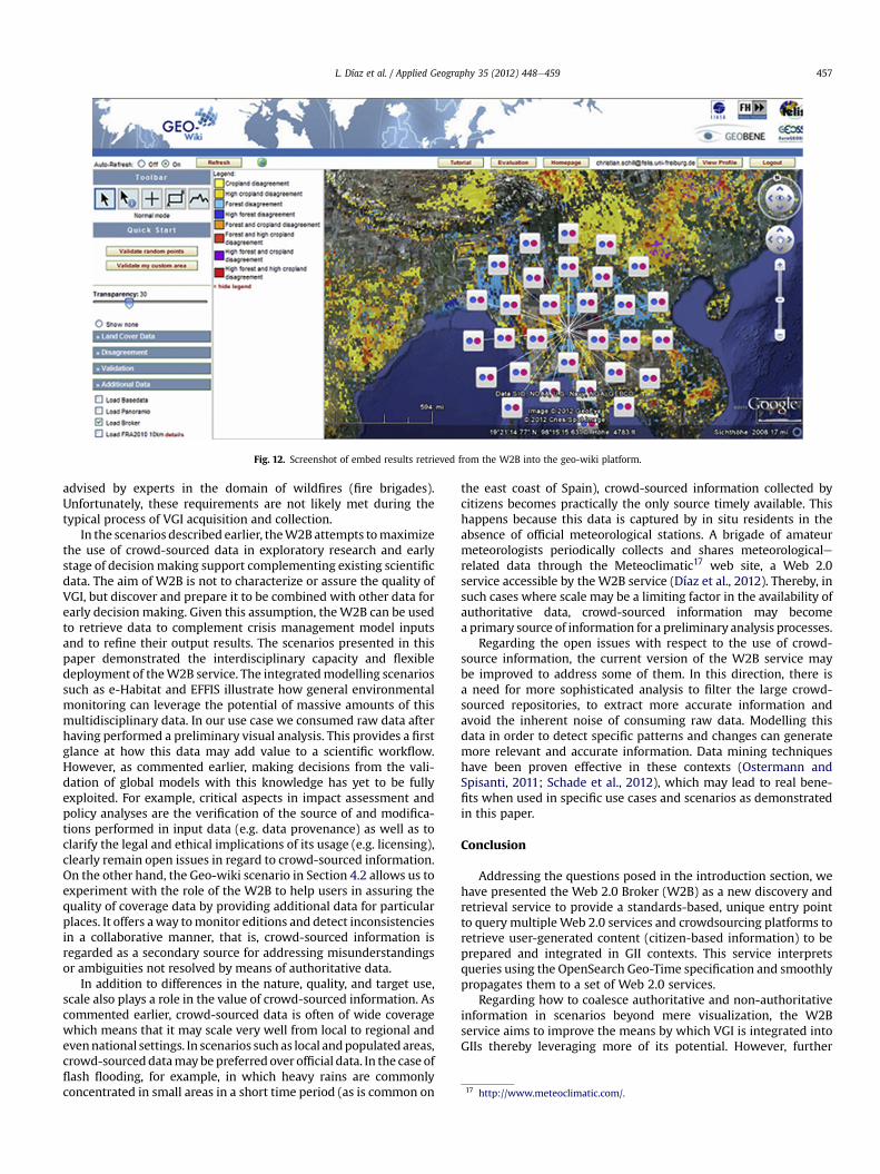
Fig. 12. Screenshot of embed results retrieved from the W2B into the geo-wiki platform.
17 http://www.meteoclimatic.com/.
L. Díaz et al. / Applied Geography 35 (2012) 448e459 457
advised by experts in the domain of wildfires (fire brigades).Unfortunately, these requirements are not likely met during thetypical process of VGI acquisition and collection.
In the scenarios described earlier, theW2B attempts tomaximizethe use of crowd-sourced data in exploratory research and earlystage of decisionmaking support complementing existing scientificdata. The aim of W2B is not to characterize or assure the quality ofVGI, but discover and prepare it to be combined with other data forearly decision making. Given this assumption, theW2B can be usedto retrieve data to complement crisis management model inputsand to refine their output results. The scenarios presented in thispaper demonstrated the interdisciplinary capacity and flexibledeployment of theW2B service. The integratedmodelling scenariossuch as e-Habitat and EFFIS illustrate how general environmentalmonitoring can leverage the potential of massive amounts of thismultidisciplinary data. In our use case we consumed raw data afterhaving performed a preliminary visual analysis. This provides a firstglance at how this data may add value to a scientific workflow.However, as commented earlier, making decisions from the vali-dation of global models with this knowledge has yet to be fullyexploited. For example, critical aspects in impact assessment andpolicy analyses are the verification of the source of and modifica-tions performed in input data (e.g. data provenance) as well as toclarify the legal and ethical implications of its usage (e.g. licensing),clearly remain open issues in regard to crowd-sourced information.On the other hand, the Geo-wiki scenario in Section 4.2 allows us toexperiment with the role of the W2B to help users in assuring thequality of coverage data by providing additional data for particularplaces. It offers away tomonitor editions and detect inconsistenciesin a collaborative manner, that is, crowd-sourced information isregarded as a secondary source for addressing misunderstandingsor ambiguities not resolved by means of authoritative data.
In addition to differences in the nature, quality, and target use,scale also plays a role in the value of crowd-sourced information. Ascommented earlier, crowd-sourced data is often of wide coveragewhich means that it may scale very well from local to regional andevennational settings. In scenarios such as local andpopulated areas,crowd-sourceddatamaybe preferred over official data. In the case offlash flooding, for example, in which heavy rains are commonlyconcentrated in small areas in a short time period (as is common on
the east coast of Spain), crowd-sourced information collected bycitizens becomes practically the only source timely available. Thishappens because this data is captured by in situ residents in theabsence of official meteorological stations. A brigade of amateurmeteorologists periodically collects and shares meteorologicalerelated data through the Meteoclimatic17 web site, a Web 2.0service accessible by the W2B service (Díaz et al., 2012). Thereby, insuch cases where scale may be a limiting factor in the availability ofauthoritative data, crowd-sourced information may becomea primary source of information for a preliminary analysis processes.
Regarding the open issues with respect to the use of crowd-source information, the current version of the W2B service maybe improved to address some of them. In this direction, there isa need for more sophisticated analysis to filter the large crowd-sourced repositories, to extract more accurate information andavoid the inherent noise of consuming raw data. Modelling thisdata in order to detect specific patterns and changes can generatemore relevant and accurate information. Data mining techniqueshave been proven effective in these contexts (Ostermann andSpisanti, 2011; Schade et al., 2012), which may lead to real bene-fits when used in specific use cases and scenarios as demonstratedin this paper.
Conclusion
Addressing the questions posed in the introduction section, wehave presented the Web 2.0 Broker (W2B) as a new discovery andretrieval service to provide a standards-based, unique entry pointto query multiple Web 2.0 services and crowdsourcing platforms toretrieve user-generated content (citizen-based information) to beprepared and integrated in GII contexts. This service interpretsqueries using the OpenSearch Geo-Time specification and smoothlypropagates them to a set of Web 2.0 services.
Regarding how to coalesce authoritative and non-authoritativeinformation in scenarios beyond mere visualization, the W2Bservice aims to improve the means by which VGI is integrated intoGIIs thereby leveraging more of its potential. However, further

L. Díaz et al. / Applied Geography 35 (2012) 448e459458
research is necessary in this field. We will continue extending thissolution by increasing the number of Web 2.0 resources to beaggregated as they become available. Additionally, wewill continueto analyse the massive data flow in order to extract observationsrelevant to specific use cases. The next steps are to define a datamodel to describe environmental observations and alarms therebyadding a new information source for emergency response scenariosand exploiting the intrinsic multidisciplinary character of the W2Bcomponent which favours a wide range of use cases.
Acknowledgements
This work has been partially supported by the FP7 Europeanproject EuroGEOSS (Project number 226487) and the GEOCLOUDproject reference (IPT-430000-2010-11, subprogram Innpacto2010; Ministerio de ciencia e innovación).
References
Aanensen, D. M., Huntley, D. M., Feil, E. J., al-Own, F., & Spratt, B. G. (2009). Epi-Collect: linking smartphones to web applications for epidemiology, ecology andcommunity data collection. PloS ONE, 4(9), e6968.
Aragó, P., Tamayo, A., Viciano, P., Huerta, J., & Díaz, L. (2011). Forest Fire Survey and Pro-cessing Tool forAndroid-BasedMobileDevices. In: INSPIREConference 2011. Edinburg.
Bailey, J. E. (2011). The role of virtual globes in geosciences. Computers &Geosciences, 37(1), 1e2.
Béjar, R., Latre, M.Á., Nogueras-Iso, J., Muro-Medrano, P. R., & Zarazaga-Soria, F. J.(2009). An architectural style for spatial data infrastructures. InternationalJournal of Geographical Information Science, 23(3), 271e294.
Beltrán, A., Abargues, C., Granell, C., Nuñez, M., Díaz, L., & Huerta, J. (2012). A virtualglobe tool for searching and visualizing geo-referenced media resources insocial networks. Multimedia Tools & Applications, . http://dx.doi.org/10.1007/s11042-012-1025-0.
Bernard, E., Barbosa, L., & Carvalho, R. (2011). Participatory GIS in a sustainable usereserve in Brazilian Amazonia: implications for management and conservation.Applied Geography, 31(2), 564e572.
Bishop, I. D., Escobar, F. J., Karuppannan, S., Suwarnarat, K., Williamson, I. P.,Yates, P. M., et al. (2000). Spatial data infrastructures for cities in developingcountries: lessons from the Bangkok experience. Cities, 17(2), 85e96.
Budhathoki, N. R., Bertram, B., & Nedovic-Budic, Z. (2008). Reconceptualizing therole of the user of spatial data infrastructure. Geojournal, 72(3e4), 149e160.
Buschmann, F., Meunier, R., Rohnert, H., Sommerland, P., & Stal, M. (1996). Pattern-oriented software architecture volume 1: A systemof patterns. JohnWiley& Sons Ltd.
Coleman, D. J., Georgiadou, P. Y., & Labonte, J. (2009). Volunteered geographicinformation: the nature and motivation of producers. International Journal ofSpatial Data Infrastructures Research, 4, 332e358.
Craglia, M., de Bie, K., Jackson, D., Pesaresi, M., Remetey-Fülöpp, G., Wang, C., et al.(2012). Digital Earth 2020: towards the vision for the next decade. InternationalJournal of Digital Earth, 5(1), 4e21.
Craglia, M., Goodchild, M. F., Annoni, A., Câmara, G., Gould, M., Kuhn, W., et al.(2008). Next-generation Digital Earth: a position paper from the vespucciinitiative for the advancement of geographic information science. InternationalJournal of Spatial Data Infrastructures Research, 3, 146e167.
Curtis, A., &Mills, J.W. (2012). Spatial video data collection in a post-disaster landscape:the Tuscaloosa Tornado of April 27th 2011. Applied Geography, 32(2), 393e400.
Davis, C. A., Jr., Fonseca, F. T., & Camara, G. (2009). Beyond SDI: integrating science andcommunities to create environmental policies for the sustainability of theAmazon. International Journal of Spatial Data Infrastructures Research, 4, 156e174.
Dessers, E., Crompvoets, J., Janssen, K., Vancauwenberghe, G., Vandenbroucke, D.,Vanhaverbeke, L., et al. (2012). Multidisciplinary research framework foranalysing SDI in the context of business processes. International Journal ofSpatial Data Infrastructures Research, 7, 125e150.
Díaz, L., Granell, C.,M., Gould, M., & Huerta, J. (2011). Managing user generatedinformation in geospatial cyberinfrastructures. Future Generation ComputerSystems, 27(3), 304e314.
Díaz, L., Nuñez, M., González, D., Gil, J., Aragó, P., Pultar, E., et al. (2012).Interoperable search mechanism for Web 2.0 resources. International Journal ofSpatial Data Infrastructure Research, 7, 2012.
Dubois, G., Skoien, J., Mendes de Jesus, J., Peedell, S., Hartley, A., Nativi, S., et al.(2011). eHabitat: A contribution to the model web for habitat assessments andecological forecasting. In Proceedings of the 34th international symposium onremote sensing of environment (pp. 1e4).
Flanagin, A. J., & Metzger, M. J. (2008). The credibility of volunteered geographicinformation. Geojournal, 72, 137e148.
Fritz, S., McCallum, I., Schill, C., Perger, C., Grillmayer, R., Achard, F., et al. (2009).Geo-Wiki.Org: the use of crowdsourcing to improve land cover. Remote Sensing,1(3), 345e354.
Fritz, S., McCallum, I., Schill, C., Perger, C., See, L., Schepaschenko, D., et al. (2012).Geo-Wiki: an online platform for improving global land cover. EnvironmentalModelling & Software, 31, 110e123.
Gonçalves, P. (Ed.), (2010). OpenGIS� opensearch geospatial extensions draftimplementation standard. Version 0.0.2. Open Geospatial Consortium Inc,Ref. OGC 09e084r3.
Goodchild, M. F. (2007). Citizens as voluntary sensors: spatial data infrastructure inthe world of Web 2.0. International Journal of Spatial Data InfrastructuresResearch, 2, 24e32.
Goodchild, M. F., Guo, H., Annoni, A., Bian, L., de Bie, K., Campbell, F., et al. (2012).Next-generation Digital Earth. Proceedings of the National Academy of Sciences,109(28), 11088e11094.
Goodchild, M. F., & Glennon, J. A. (2010). Crowdsourcing geographic information fordisaster response: a research frontier. International Journal of Digital Earth, 3(3),231e241.
Goodchild, M. F., & Li, L. (2012). Assuring the quality of volunteered geographicinformation. Spatial Statistics, 1, 110e120.
Granell, C., Díaz, L., & Gould, M. (2010). Service-oriented applications for environ-mental models: reusable geospatial services. Environmental Modelling & Soft-ware, 25(2), 182e198.
INSPIRE EU Directive. (2007). Directive 2007/2/EC of the European Parliament andof the Council of 14 March 2007 establishing an Infrastructure for SpatialInformation in the European Community (INSPIRE). Official Journal of theEuropean Union, L 108/1, 50.
Kates, R. W., Clark, W. C., Corell, R., Hall, J. M., Jaeger, C. C., Lowe, I., et al. (2001).Sustainability science. Science, 292(5517), 641e642.
McInerney, D., Bastin, L., Díaz, L., Figueiredo, C., Barredo, J. I., & San-Miguel-Ayanz, J.(2012). Developing a forest data portal to support multi-scale decision making.IEEE Journal of Selected Topics in Applied Earth Observations and Remote Sensing, .http://dx.doi.org/10.1109/JSTARS.2012.2194136.
Masser, I. (2005). GIS Worlds: Creating spatial data infrastructures. Redlands: ESRIPress.
Masser, I., Rajabifard, A., & Williamson, I. (2007). Spatially enabling governmentsthrough SDI implementation. International Journal of Geographical InformationScience, 22(1), 5e20.
Munro, R. (2012). Crowdsourcing and the crisis-affected community: Lessons learnedand looking forward from mission 4636. Information Retrieval. http://dx.doi.org/10.1007/s10791-012-9203-2.
Nativi, S., Craglia, M., & Pearlman, J. (2012). The brokering approach for multidis-ciplinary interoperability: a position paper. International Journal of Spatial DataInfrastructure Research, 7, 1e15.
Nativi, S., Craglia, M., Vaccari, L., Santoro, M. (2011). Searching the New Grail: inter-disciplinary interoperability. In Proceedings of the 14th AGILE internationalconference on Geographic information science e advancing geoinformation sciencefor a changing world, Utrecht, 2011. AGILE. (AGILE 2011). Utrecht, TheNetherlands, April 2011.
Nebert, D. (Ed.), (2004). Developing spatial data infrastructures: The SDI Cookbook.GSDI.
Neis, P., Zielstra, D., & Zipf, A. (2012). The street network evolution of crowdsourcedmaps: openstreetmap in Germany 2007e2011. Future Internet, 4(1), 1e21.
Newell, D. A., Pembroke, M. M., & Boyd, W. E. (2012). Crowd sourcing for conser-vation: Web 2.0 a powerful tool for biologists. Future Internet, 4(2), 551e562.
Omran, E. L. E., & van Etten, J. (2007). Spatial-data sharing: applying social-networkanalysis to study individual and collective behaviour. International Journal ofGeographical Information Science, 21(6), 699e714.
Ostermann, F., & Spinsanti, L. A conceptual workflow for automatically assessing thequality of volunteered geographic information for crisis management. InProceedings of the 14th AGILE international conference on geographic informationscience e Advancing geoinformation science for a changing world, Utrecht, 2011.AGILE. (AGILE 2011). Utrecht, The Netherlands, April 2011.
Pearlman, J., & Shibasaki, R. (2008). Global earth observation system of systems.IEEE Systems Journal, 2(3), 302e303.
Pultar, E., Raubal, M., Cova, T. J., & Goodchild, M. F. (2009). Dynamic GIS case studies:wildfire evacuation and volunteered geographic information. Transactions inGIS, 13(s1), 85e104.
Rajabifard, A., Feeney, M.-E. F., & Williamson, I. P. (2002). Future directions for SDIdevelopment. International Journal of Applied Earth Observation and Geo-information, 4, 11e22.
Reid, W. V., Chen, D., Goldfarb, L., Hackmann, H., Lee, Y. T., Mokhele, K., et al. (2010).Earth system science for global sustainability: grand challenges. Science,330(6006), 916e917.
Roche, S., Propeck-Zimmermann, E., & Mericskay, B. (2012). Geoweb and crisismanagement: issues and perspectives of volunteered geographic information.Geojournal, . http://dx.doi.org/10.1007/s10708-011-9423-9.
Schade, S., Díaz, L., Ostermann, F., Spinsanti, L., Luraschi, G., Cox, S., et al. (2012).Citizen-based sensing of crisis events: sensor Web enablement for volunteeredgeographic information. Applied Geomatics, . http://dx.doi.org/10.1007/s12518-011-0056-y.
Schill, C., Perger, C., Fritz, S., McAllum, I., Díaz, L., Nativi, S, et al. (2012). Web 2 toolsto improve global land cover: linking the EUROGEOSS broker and geo-wiki. InEuroGEOSS conference. Madrid 25e27 January 2012.
Singleton, A. D., & Longley, P. A. (2009). Geodemographics, visualisation, and socialnetworks in applied geography. Applied Geography, 29(3), 289e298.
Tamayo, A., Granell, C., & Huerta, J. (2012). Measuring complexity in OGC webservices XML schemas: pragmatic use and solutions. International Journal of

L. Díaz et al. / Applied Geography 35 (2012) 448e459 459
Geographical Information Science, 26(6). http://dx.doi.org/10.1080/13658816.2011.626602, ISSN 1365e8816. Taylor & Francis.
Tulloch, D. L. (2007). Many many maps: empowerment and online participatorymapping. First Monday, 12(2), Available at: http://firstmonday.org/htbin/cgiwrap/bin/ojs/index.php/fm/article/view/1620/1535.
Turner, A. (2006). Introduction to neogeography. Sebastopol: O’Reilly Media Inc.Vaccari, L., Craglia,M., Fugazza, C., Nativi, S., & Santoro,M. (2012). Integrative research:
the EuroGEOSS experience. IEEE Journal of Selected Topics in Applied Earth Obser-vations and Remote Sensing, . http://dx.doi.org/10.1109/JSTARS.2012.2190382.
Yang, C., Raskin, R., Goodchild, M. F., & Gahegan, M. (2010). Geospatial cyberin-frastructure: past, present and future. Computers, Environment, and UrbanSystems, 34(4), 264e277.
Zlatanova, S., & Fabbri, A. G. (2009). Geo-ict for risk and disaster management. InScholten., v/d Velde., & van Manen. (Eds.), Geospatial technology and the role oflocations in science (pp. 239e266). Dordrecht: Springer.
Zook, M., Graham, M., Shelton, T., & Gorman, S. (2010). Volunteered GeographicInformation and Crowdsourcing Disaster Relief: A Case Study of the HaitianEarthquake. World Medical & Health Policy, 2(2), 6e32.