· web viewappendix 2 - minnamurra river: from source to sea. created by andy grant, suzanne...
TRANSCRIPT
The Geography Bulletin: Student activities Edition 3, 2019 (Volume 51, No 3)
Appendix 2 - Minnamurra River: From Source to Sea
Created by Andy Grant, Suzanne Johnson, Mark Peters and David Brennan for GTANSW & ACT
The Geography Bulletin 2019 Edition 3 (Volume 51 No 3)https://www.gtansw.org.au/members/login.php
This document has been provided in both PDF and Word formats to allow teachers to add or delete elements as appropriate to their students.
Login to your account to access the relevant GTA Bulletin article.
The following data collection sheets are to be used by students when undertaking theMinnamurra River: From Source to Sea Fieldwork activity or similar fieldwork activity in another location.
Created by Kiama Conference attendees for GTANSW & ACT for Bulletin 3, 2019
The Geography Bulletin: Student activities Edition 3, 2019 (Volume 51, No 3)
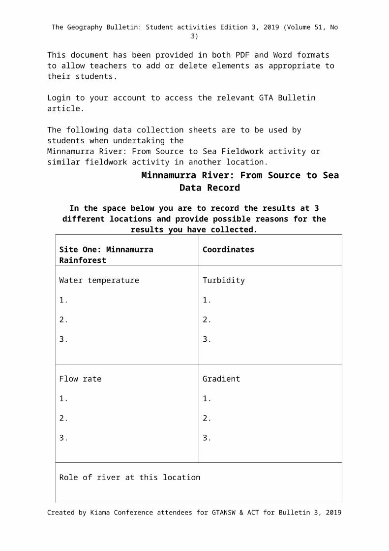
Minnamurra River: From Source to SeaData Record
In the space below you are to record the results at 3 different locations and provide possible reasons for the results you have collected.
Site One: Minnamurra Rainforest Coordinates
Water temperature
1.
2.
3.
Turbidity
1.
2.
3.
Flow rate
1.
2.
3.
Gradient
1.
2.
3.
Role of river at this location
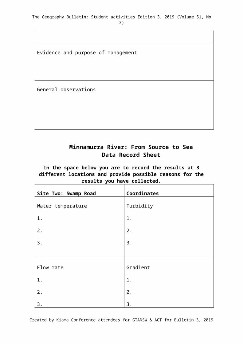
Evidence and purpose of management
General observations
Created by Kiama Conference attendees for GTANSW & ACT for Bulletin 3, 2019
The Geography Bulletin: Student activities Edition 3, 2019 (Volume 51, No 3)
Minnamurra River: From Source to Sea Data Record Sheet
In the space below you are to record the results at 3 different locations and provide possible reasons for the results you have collected.
Site Two: Swamp Road Coordinates
Water temperature
1.
2.
3.
Turbidity
1.
2.
3.
Flow rate
1.
2.
3.
Gradient
1.
2.
3.
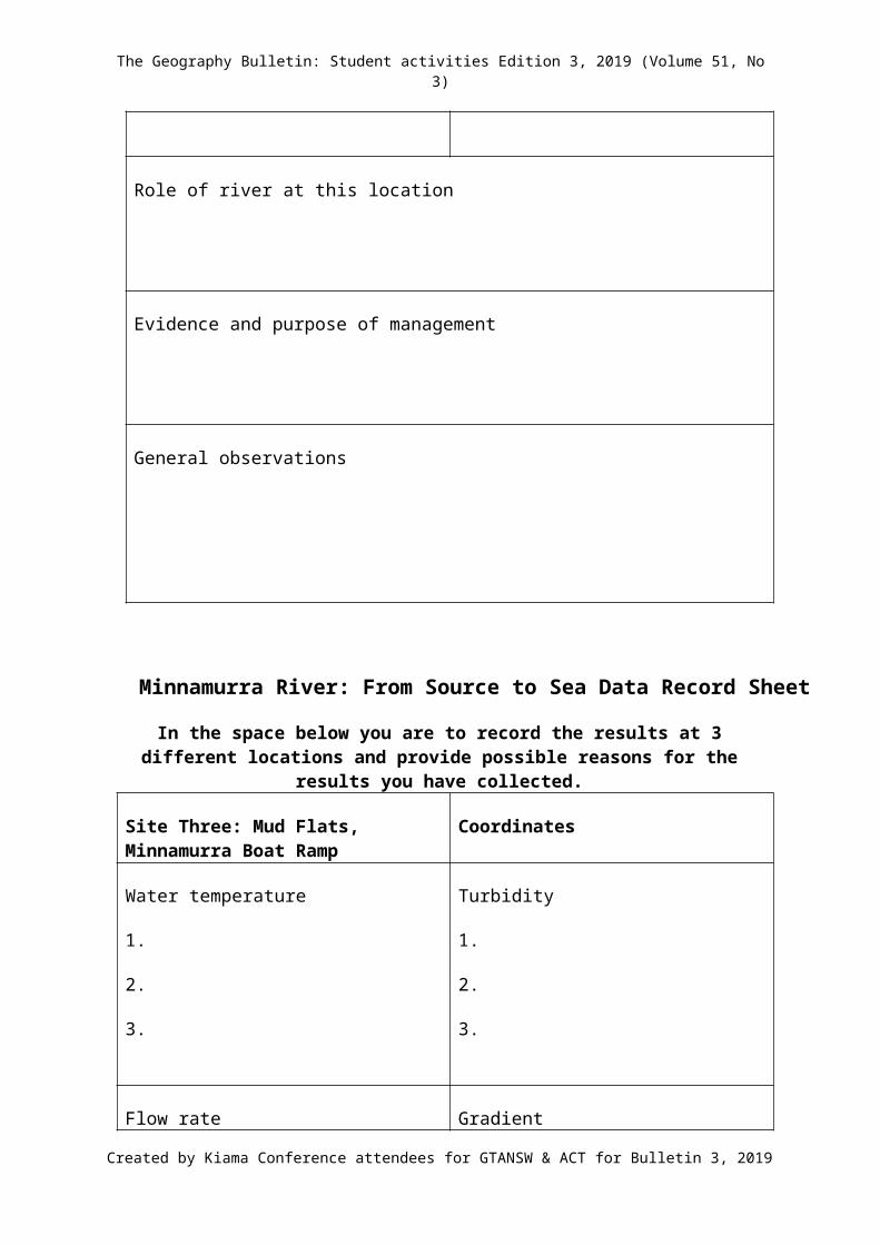
Role of river at this location
Evidence and purpose of management
General observations
Created by Kiama Conference attendees for GTANSW & ACT for Bulletin 3, 2019
The Geography Bulletin: Student activities Edition 3, 2019 (Volume 51, No 3)
Minnamurra River: From Source to Sea Data Record Sheet
In the space below you are to record the results at 3 different locations and provide possible reasons for the results you have collected.
Site Three: Mud Flats, Minnamurra Boat Ramp
Coordinates
Water temperature
1.
2.
3.
Turbidity
1.
2.
3.
Flow rate
1.
2.
3.
Gradient
1.
2.
3.
Role of river at this location
Evidence and purpose of management
General observations
Created by Kiama Conference attendees for GTANSW & ACT for Bulletin 3, 2019