images.pcmac.orgimages.pcmac.org/.../documentscategories/documents/… · web viewlargest...
TRANSCRIPT
APHUG FURLONG
APHUG STUDY GUIDE
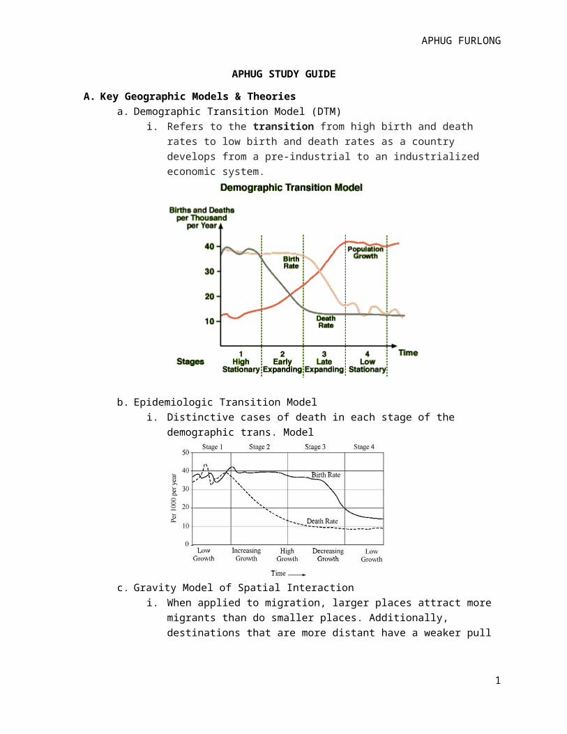
A. Key Geographic Models & Theoriesa. Demographic Transition Model (DTM)
i. Refers to the transition from high birth and death rates to low birth and death rates as a country develops from a pre-industrial to an industrialized economic system.
b. Epidemiologic Transition Modeli. Distinctive cases of death in each stage of the demographic trans. Model
c. Gravity Model of Spatial Interactioni. When applied to migration, larger places attract more migrants than do smaller
places. Additionally, destinations that are more distant have a weaker pull effect than do closer opportunities of the same caliber.
1

APHUG FURLONG
d. Zelinksy Model of Migration Transitioni. Migration trends follow demographic transition stages. People become
increasingly mobile as industrialization develops. More international migration is seen in stage 2 as migrants search for more space and opportunities in countries in stages 3 & 4. Stage 4 countries show less emigration and more intraregional migration.
e. Ravenstein’s Law of Migration
2

APHUG FURLONG
f. Von Thünen Model of Agricultural Land Usei. German geographer Johann Heinrich con Thünen
ii. Explains and predicts agricultural land use patternsiii. Thünen's model of agricultural land, created before industrialization, made the
following simplifying assumptions:
The city is located centrally within an "Isolated State."
The Isolated State is surrounded by wilderness.
The land is completely flat and has no rivers or mountains.
Soil quality and climate are consistent.
Farmers in the Isolated State transport their own goods to market via oxcart, across land, directly to the central city. There are no roads.
Farmers behave rationally to maximize profits.
g. Least Cost Theoryi. Alfred Weber theory of industrial location
ii. Explains and predicts where industries will locate based on cost analysis of transportation, labor, and agglomeration factors
iii. Assumes an industry will choose its location based on desire to minimize production costs & maximize profits
iv. Drawbacks are assumption of immobile and equal labor force
3

APHUG FURLONG
h. Locational Interdependencei. Hotelling’s theory asserts that an industry’s locational choices are heavily
influenced by the location of their chief competitors and related industriesi. Rostow’s Stages of Economic Development
i. 1950s, example of liberal development ideology, as opposed to structuralist theory
ii. All countries develop in five-stage processiii. Initiated by investment in a takeoff industry which sparks greater economic gain
that eventually diffuses throughout economyiv. Drawbacks include: not identifying cultural & historical development differences
because its base on North American & western European development
4

APHUG FURLONG
j. Borchert’s Model of Urban Evolutioni. Created in 1960s to predict & explain growth of cities in four phases of
transportation; fifth stage later added.
k. Central Place Theoryi. Hexagonal Market Areas predicted by Walter Christaller 1930s
ii. Explains & predicts patterns of urban spaces across the map
5

APHUG FURLONG
Unit Overviews
1. Geography: Its Nature and Perspectivesa. Geographers most interested looking into space and identifying, explaining, and
predicting human and physical patterns that developb. The Five Themes:
i. Location: explains where something is on Earth1. Absolute location-something’s location on global grid; lines of latitude
(parallel), lines of longitude (meridians)2. Only equator can serve as base line for latitude3. Prime Meridian (GMT) is base for longitude but technically any line can
serve as zero degrees longitude4. Relative location-something’s relationship to the places around it5. Site & Situation-describe place location
a. Site-place’s internal physical & cultural characteristicsb. Situation- location of context of a place relative to physical and
cultural characteristics around itii. Human Environment Interaction: how humans affect their environment and
how environmental changes impact human life1. Cultural ecology-study of aspects and outcomes of human-environment
interactioniii. Regions: a spatial unit, or group of places, that share similar characteristics
1. Three types:a. Formal region- are with common cultural or physical featuresb. Functional region-group of places liked by some type of
movementc. Perceptual region- group of places linked b/c of perceptions
about the regioniv. Place: All of human and physical attributes in location
1. Human attributes- religion, clothing, languages, politics, art2. Physical attributes- climate, terrain, natural resources3. The above give a place its “sense of place” that is different from other
placesv. Movement: all types of movement in a space-information, people, goods, and
more1. Spatial interaction-how places interact with each other2. Friction of distance-degree to which distance interferes or reduces the
amount of interaction between two places3. Distance decay- intensity of some phenome decreasing as distance from
it increasesc. Geographic Models
i. Created to understand why spatial patterns exist in the ways they doii. Demographic Transition Model-population change over time
d. Physical v. Human Geographyi. Physical- primarly concerned with spatial analysis of Earth’s natural phenomena
6

APHUG FURLONG
ii. Human- primarily concerned with spatial analysis of human patters on the Earth and their interactions with Earth
e. Mapmakingi. Cartography- process of making a map
1. Maps are 2-D model of Earth or portion of itii. Distortion- impossible to make round Earth on flat surface without distortion
(error)1. Globe is most accurate
iii. Four Properties of Maps1. Shape-geometric shapes of objects on map2. Size- relative amount of space take up on map by landforms or objects3. Distance- measurements between objects on map4. Direction- degree of accuracy representing cardinal directions (NESW)
iv. Projections1. Gall-Peters projection is equal area b/c it represents actual area of
landforms but distorts other properties like shape2. Mercator- conformal b/c it accurately represents shape of landforms
but not equal area b/c landforms are drastically distorted3. Equidistant- maintain distance but distort other properties4. Robinson- compromise projection b/c neither equal nor conformal; all
are slightly distorted, none drastically5. Azimuthal projection-flat-plan, direction is accurate and great circles are
evident6. Cognitive- (mental) drawn from memory, often reflect spatial
perceptions of those who draw themv. Scale- refers to relationship between distance on map & actual real world
measurement1. Scale of inquiry-scope of geographic analysis
vi. Categories of Maps1. Reference maps2. Thematic Maps3. Isoline thematic maps4. Chlorpleth Maps5. Proportional thematic maps6. Dot density maps7. Cartogram
f. Geographic Technology & Datai. Geographic Information Systems (GIS)- computer program that stores data and
produces maps through layeringii. Remote sensing-collection of information from satellites
iii. Global Position Systems (GPS)- satellite driven remote sensingiv. Primary v. Secondary Data- directly collected by geographer or data collected at
an earlier time being used laterv. Data Aggregation-size of geographic units presented on map
7

APHUG FURLONG
vi. Modifiable areal unit problem (MAUP) sometimes a source of error impacting spatial studies that uses data that’s been grouped
2. Populationa. Demography- study of human populationsb. Population Distribution- pattern of people across Earth’s surface, unevenly distributed
throughout historyi. Clustered around bodies of water and arable land
ii. 75% of all population live on 5% of Earth’s surfaceiii. Global population distribution
1. 80% lives in poor, LDCs in Latin America, Asia, & Africa2. Largest concentration in East Asia (China, Japan, Taiwan, North & South
Korea)3. Second largest in South Asia4. Third largest in Europe
iv. Population Density- the number of people in a particular area1. Arithmetic density-total number people divided by total land area2. Physiological density- number of people per unit of arable land3. Agricultural density- number of farmers per unit of arable land
v. Population Equation1. Global demographic accounting equation- calculates global population
change during an interval of time: P1=P0+B-D2. Sub-global demographic accounting equation-adds in immigration and
emigration: P1-P0+B-D+I-E3. Overpopulation-when region’s population outgrows its carrying capacity4. Carrying capacity- number of people the area can sustain5. Infrastructure-support systems in a region including, housing, police,
roads, education, food supplies, and health care6. Cohort-group of people that are same age
vi. Dependency Ratio-compares people not in workforce with those who are1. 15-64 considered nondependent
vii. Key Measurements of Fertility & Mortality1. Crude birth rate (CBR)- number of live births per 1000 per year2. Crude Death rate (CDR)- number of deaths per 1000 per year3. Rate of Natural Increase (RNI)-growth rate of population excluding
immigration & emigration4. Infant Mortality Rate (IMR)-number of infant deaths per 1000 live births
per year5. Life expectancy-avg number of years to be live by person6. Fecundity- ability of a woman to conceive, generally ages 15-457. General Fertility Rate (GFR)- number of births per 1000 women in their
fecund years8. Total fertility rate (TFR)-predicted number of births a woman will have
as she passes through her fecund yearsviii. Population Growth and Decline over space and time
8

APHUG FURLONG
1. 300 Earth has experienced dramatic increase in population2. 10k-12k years ago First Agricultural Revolution-domestication of crops3. 1700s Industrial Revolution diffused from England caused Second
Agricultural Revolution (new technology/machinery)ix. Theories of Population Growth
1. Thomas Malthus-population growing exponentially but food supply growing at slower rate
2. Karl Marx- problem isn’t population growth but unequal distribution of wages and resources
3. Ester Boserup- believed overpopulation could be avoided by increasing number of subsistence farmers
x. Population Policies1. Pro-natalist- (expansive) government to promote reproduction & bigger
families (tax breaks for families)2. Anti-natalist- (restrictive) discourage reproduction (one-child policies)
xi. Population Predictions1. Low-growth scenario- Earth’s population will begin declining, 7.5 billion
by 2050 & 5.1 billion by 21002. High-growth scenario- global population of 11 billion by 2050 & 16
billion by 2100xii. Epidemic v. Pandemic
1. Pandemic disease- HIV/AIDS affects very large numbers at global level2. Epidemic disease- affects local regions
xiii. Demographic Transition Model3. Migration- process of permanently moving from home region and crossing borders between
counties, states, or countriesa. Push & Pull factors-
i. Push-negative influences that make a person want to move, high taxes, high crime rates, abusive gov’t
ii. Pull-positive influences that pull a person towards a particular place; good schools, affordable housing, clean parks
b. Migration Streams- pathway from place of origin to a destinationi. If place has more people coming than going they have net in-migration
ii. If place has more leaving than staying they have net out-migrationc. Chain migration- develop because of information exchanged. Voluntary v. forced migration- migrant have option to move or are pushed from their
landi. Major regions of dislocation & refugees: Sub-Saharan Africa, Middle East,
Europe, & SE Asiae. Major Migrations over time:
i. U.S has seen three major waves of immigration1. Colonial era, both voluntary & involuntary to New World2. 19th century most from Ireland & Germany3. In 1980s-90s Asian and Latin American immigrants
9

APHUG FURLONG
ii. Internal Migration-movement within a country1. Interregional-from one region to another2. Intraregional-moving within a region (city to suburb)3. U.S. shifted population: Great Migration during WWI, 1970s return to
South; from Rustbelt in NE to Sunbelt in South as factories closedf. Predicting & explaining migration
i. Migration selectivity-evaluation of how likely someone is to migrate based on personal, social, and economic factors
ii. Education is major facto-more educated make longer movesiii. Ravenstein’s Migration laws: majority travel short distances, migrants traveling
far move to cities, rural more likely to migrate than urbaniv. Gravity Model-estimates spatial interaction and movement between two placesv. Zelinsky’s Model of Migration Transition-explains migration based on country’s
stage in demographic model4. Cultural Patterns and Processes
a. Conceptsi. Cultural geography- study of people’s lifestyles, creations, and relationships to
the Earth and supernatural; how and why culture is expressed1. Material components of culture- include tangible artifacts2. Non-material components of culture- thoughts and ideas of people such
as religion and lawsii. Cultural Landscape- physical imprint a culture makes on the environment
1. Carl Sauer-20th century geographer championed study of cultural landscape
2. Cultural ecology-study of human-environment interactioniii. Sequent Occupancy-theory that place can be occupied by different groups of
people and each group leaves its imprint from which the next group learnsb. Geographic Theories explaining Human-environment Interaction
i. Environmental determinism-theory developed as early as Greeks that argues human behavior is controlled by physical environment
ii. Possibilism-theory that developed as counterargument to environmental determinism; argues natural environment sets limits on set of choices available to people
iii. Cultural Determinism-theory that environment places no restrictions on humans whatsoever, only restrictions are those created by humans themselves
c. Political Ecology- attempts to answer why human cultures interact with environments in the ways they do; asserts gov’t of region affects environment of region which affects choices available to people
d. Layers of Culturei. Culture trait-single attribute of culture
ii. Culture complex-unique set of traits of combination of culture traitsiii. Culture regions- regions drawn around places/peoples with similarities in
culture systems
10

APHUG FURLONG
iv. Regional identity-emotional attachment to group of people & places associated with culture region
v. Culture realms-formed through fusing together of culture regions that share enough in common to be merged together
vi. Cultural Diffusion-material and nonmaterial human creations spreading across time and space
vii. Spatial diffusion-any phenomenon sucha s dieseas spreading across spaceviii. Two categories of diffusion
1. Expansion- spreads outward to new places while remaining strong in its hearth
a. Stimulus-idea diffuses from hearth outward but idea is changed by new adopters
b. Hierarchical-concept spreads from place or person of powerc. Contagious- diffusion occurs when numerous places/people
near hearth become adopters (or infected)2. Relocation-involves actual movement of original adopters from point of
origin to a new placea. Migrant diffusion-innovation spreads, lasts short time
3. Culture hearths-areas where innovations in culture began such as where agriculture, gov’t, and urbanization originated
4. Torsten Hagerstrand- theorized all innovation diffuse from hearths in stages; Diffusion S-Curve
5. Cultural convergence v. divergence
11

APHUG FURLONG
a. Convergence occurs when two cultures come into contact with one another and the weaker of the two adopts traits from the more dominant culture
b. Divergence occurs when two cultures become increasingly different, often when one moves away from territory or group
e. Ethnicity & Racei. Ethnicity-core component of cultural identity and relates to set of norms that
people create and define “their group”ii. Race-classification system of humans based on skin color and other physical
characteristicsf. Ethnic Conflict
i. Social distance-measures how distant two ethnicities or social groups are from each other but not in spatial sense
ii. Ethnic cleansing- a race or ethnic group attempts to expel from a territory another race or ethnic group
iii. Genocide- killing of race or ethnic group by another race/ethnic groupg. Gender
i. Classification of biological and social differences between men & womenii. Gender gap-differences in social, economic, and political power & opportunity
between men & womeniii. Patterns related to gender gap: high maternal mortality rate- women in poor
regions are 100-600 X more likely to die giving birth than women in wealthier countries, female infanticide rates- murder of female infants in regions where families want male children, dowry death- when bride is murdered by husband’s family b/c her father failed to pay dowry, women not given right to vote in most places until 20th century, gender imbalances-countries where men outnumber women
h. Folk & Popular Culturei. Folk- limited to smaller region and smaller groups of people
1. Isolated groups, long-lasting traits that haven’t changed much2. Spreads though relocation diffusion
ii. Popular- mass culture that diffuses rapidly1. Spreads through expansion diffusion2. Some believe pop culture threatens local or regional distinctiveness and
cause cultural sameness5. Religion
a. Fundamental part of human culture, is set of beliefs & activities that help humans celebrate & understand their place in the world
b. Universalizing v. Ethnic Religionsi. Universalizing have universal appeal & attract all people
ii. Branches, denominations, sectsiii. Ethnic religions attempt to appeal to one group in a specific place or ethnicity
c. Monotheistic v. Polytheistici. Monotheistic-Belief in one supreme being; Christianity, Islam, Judaism
12

APHUG FURLONG
ii. Polytheistic- belief in more than one supreme beingd. Buddhism- world’s first universalizing religion, founded by Prince Siddartha Guatama,
350 million people worldwidee. Christianity-second universalizing religion, an offshoot of Judaismf. Islam- third major universalizing religion, originated in Mecca through prophet
Muhammad6. Language
a. Culture trait, learned from one generation to anotherb. 2.5 millions years ago developedc. diffused through migration then divergence occurredd. Reverse reconstruction- process of tracking language diffusione. Language tree
i. 19 language families, each has own branches, branch has own groups, group has own language, language has own dialects
f. Language related conflicti. Multilingual states-contain linguistic minorities, can lead to struggles over
national identity and powerii. Monolingual states-speakers of only one language, can’t exist well in globalized
worldiii. Lingua franca- language used to facilitate trade among groups of different
language speakersg. Place Names
i. Toponyms-reflect cultural identity & impact cultural landscapeii. Can give clues to origins of related cultures
7. Political Organization of Spacea. Study of political human political organizationb. Three scales-supranational, national, and sub-national (local)c. Sovereignty-internationally recognized control of a place over the people and territory
within its bordersd. States-used to refer to countriese. Nations-refer to groups of people who share common culture and identify as cohesive
groupf. Multinational states v. nation-states- state or country that includes more than one
nation within its borders (Soviet Union) v. a state with only one nation in its borders (Japan)
g. Buffer state-independent country located between two larger countries that are in conflict, Russia & China have Mongolia as buffer
h. Satellite states-countries controlled by more powerful state (Taiwan is to China)
13

APHUG FURLONG
i. Shatterbelts-state or group of states that exist within sphere of competition between larger states and is often splintered culturally, economically, & politically (Eastern Europe post Cold War)
j. Political Boundaries-i. Geometric-straight line don’t relate to culture or physical features
ii. Physical-run along natural featuresiii. Cultural-divide according to religion or language
k. Frontiers- regions where boundaries are underdeveloped and territory is unclear (Antarctica)
l. Shapes of states
m. Enclaves & Exclavesi. enclave-state or part of state surrounded completely by another state (Lesotho
in South Africa)ii. exclave- land that is political extension of another state (Alaska to US)
n. microstate- very small self-governing state (Singapore)o. Colonialism & Imperialism
i. Colonialism-control by one state over another place, colonizing state usually has more industrialized economy than region it’s taking over
ii. Mercantilism- state acquires colonies that can provide raw materials to ship back to the mother country
iii. Imperialism- process of Est political, social, & economic dominance over a colonized area
iv. Dependency theory- many countries are poor today because of their colonization by European powers
v. Neocolonialism- continued economic dependence of new states on their former colonial masters
p. Organic theory- 19th century geopolitical, Friedrich Ratzel, argues states that are living organisms that hunger for land want to grow larger (Hitler used theory to justify invasions)
q. Heartland Theory- Halford Mackinder, Eurasia was key to dominating the world, linked to Communist efforts to dominate Eastern Europe and the US
r. Domino Theory- Cold War, democratic allies must protect from spread of communisms. Political Challenges
i. Core-region in state where political and economic power is concentratedii. Multicore states-countries having more than one core
14

APHUG FURLONG
iii. Primate cities-a capital city that is political and economic power of stateiv. Forward capital-capital city built by states in order to achieve some national goalv. Gerrymandering-redrawing electoral boundaries to give a political party and
advantage vi. Centrifugal forces-divide and tear state’s people and regions
vii. Centripetal forces-unify a state’s people and regionsviii. Devolution- process of transferring some power from the central government to
regional governmentsix. Supranationalism-growing trend to organize political and economic affairs at the
international level rather than national level8. Agricultural & Rural Land Use
a. Agriculture-growing of plants or raising of animals in order to produce food for sustenance for sale at market
b. Subsistence farming- when farmer grows only enough food to feed his own familyi. Shifting cultivation-farmers rotate fields in order to allow soil to replenish
nutrientsii. Slash-and-burn- land cleared by cutting existing plants and burning rest, form of
extensive subsistence farming (causes environmental problems)iii. Intensive subsistence farming- cultivating land very efficiently to produce food
for family (areas of high population)c. Commercial farming- farmers grow food to be sold in groceries and marketsd. Pastoralism-form of subsistence farming involving breeding & herding animalse. Origins- humans evolved from hunters/gatherers, diffused from multiple hearths
i. Carl Sauer-humans first learned to grow plants in SE Asia through vegetative planting (cutting stems and replanting)
f. First Agricultural revolution-12k years ago human development of seed agricultureg. Second Agricultural Revolution- coincided with Industrial Revolution, more efficient
machinery, movement towards urban areash. Mediterranean Agriculture-primarily associated with the region near the Mediterranean
Sea and places with climatesi. Mixed crop & livestock farming- farm that grows crops and raises animalsj. Ranching-commercial grazing or animal raisingk. Von Thunen Agricultural Location Theoryl. Third Agricultural Revolution- began in 19th century America, globalization of
mechanized technology and chemical fertilizersm. Green Revolution-began in 1940s, new strains of hybrid seeds & fertilizers invented that
dramatically increased crop outputi. Biotechnology- using living organisms to produce or change plant or animal
byproductsn. Agribusiness-combination of pieces of food-production industry, including, farms,
processing plants, packagers, fertilizer labs, distributors and advertisingo. Esther Boserup’s Theoryp. Soil erosion-trying to grow foods at faster rates and not allow soil enough time to
recoup nutrients destroying the fertile topsoil
15

APHUG FURLONG
9. Cities & Urban Land Usea. Urban hearths-cities born around 3500 BCE and spawned from agricultural villagesb. Preindustrial cities- developed prior to industrialization
i. Greek & Roman Empires most well-knownii. After fall of Roman empire cities declined on feudal system
iii. Colonial cities emerged with European imperialismiv. Diverse mix of economic functionsv. Shops, markets, homes jumbled together, wealthier living close to city center
c. “urban banana”-crescent shaped trade-centers extending from London to Tokyod. Industrialization & city structure-1800 5% people live in cities, 2010 50.5% people live in
citiesi. Mid 1700s sea trade centers emerged
ii. 1900s greatest cities were industrial cities (Manchester, Chicago, Barcelona)iii. Shock cities0urban places experiencing infrastructural challenges related to
massive and rapid urbanizationiv. Squatter settlements-makeshift, unsafe housing on land they don’t rent or ownv. Uneven development and diffusion; currently highest rates of urbanization
occurring in LDCse. Urban Systems & Central Place Theory
i. Urban systems-cities operate within a network of spatial interaction, each are interdependent on one another
ii. Christaller’s Central Place Theory-studies geographical patters of urban land use based on hexagonal market areas
iii. World and megacities1. Rank-size rule-there is relationship between city’s population size and
place on the urban hierarchy within its urban population2. Primate city-urban cities that have disproportionately large cities3. World city-powerful cities that control a disproportionately high
number of world’s economic, political, and cultural activities4. Megacities-high degree of centrality and primacy (less than world city)
and high level of influence over their country’s economies 5. Berchert’s Model of Urban Evolution
f. Comparative Models of North American Citiesi. Central business district (CBD)-original core of city’s economy
ii. Concentric Zone Modeliii. Bid-rent curveiv. Sector land use modelv. Multiple-Nuclei Model
vi. Urban Realms Modelg. Latin American Cities
i. Ford-Griffin Modelh. Uneven development-urban development not spread equally among city’s areasi. Edge cities-self-sufficient urban villages that often develop at highway exits and are part
of a larger metro complex
16

APHUG FURLONG
j. Ghettoization-growth of areas of concentrated povertyk. Gentrification- process where older urban zones are rediscovered and renovatedl. Functional character of cities
i. Basic jobs-jobs that bring money into area giving it its primary functionii. Non-basic jobs-jobs that shift money within the city
10. Industrialization & Economic Developmenta. Industrialization-growth of manufacturing activity in economy or a regionb. Economy-system of production, consumption, and distribution in a regionc. Major Economic classifications
i. Primary sector-raw materials (fishing, lumber)ii. Secondary sector-processing raw materials (raw corn into baby food),
manufacturingiii. Tertiary- professional and financial services (bank tellers, carpet cleaners)iv. Quaternary sector-economic activity involves information creation and transfer
(researchers, investment analysts)v. Quinary sector-sub class of quaternary, highest level of decision making
(congress, president, billionaire CEO, gov’t targeted research)d. Diffusion of industrialization
i. Industrial Revolution 1760s in Englandii. Rapid socio-economic change, machines replaced human labor, beginnings of
assembly lineiii. Began with coal energy, by 1960s oil became dominant source of energyiv. Commodification of labor-human labor as objects for tradev. 1920s Ford production method (assembly line based on division of labor)
vi. Alfred Weber’s Least Cost Theory-assumed industries want to maximize profits and minimize costs
vii. Bulk-losing processes-raw materials become less weight/size when manufactured (paper)
viii. Bulk-gaining-raw materials become more weight/size when manufactured (beverage bottling)
ix. Agglomeration-when industries clump together to share resourcesx. Deglomeration- unclumping due to high costs of overcrowding
e. GDP-value of total outputs of goods produced in a country per yearf. GNP-includes all goods/services owned and produced by a country overseasg. Informal sector-business transactions not reported to gov’t (street vendors, drugs,
prostitutes)h. UN Human Development Index- formula used by UN to measure country’s development
based on education, welfare, health care, and economic systemsi. Dependency Theory-argues LDCs are locked into a cycle of underdevelopment that
supports unequal structurej. Core-Periphery Model-world’s countries are in three groups
i. Core-industrialized countries, semi-periphery-newly industrialized, periphery-LDCs with low industrialization
17

APHUG FURLONG
k. Rostow’s Modernization Model-set in 1950s to explain and predict countries’ patterns of economic development
l. Improving Economic Developmenti. Self-sufficiency approach-pushed LDCs to provide for their own countries
limiting importsii. International Trade Approach-direct investment towards one or two industries
and trading globallyiii. Structural adjustments-involves supranational organizations to lend money
based on structural adjustmentsiv. Non-governmental organizations-run by charities and private organizations to
encourage infrastructure (Doctor’s without Borders)m. Globalization- increasing sense of interconnectedness and spatial interaction among
governments, cultures, and economies
18