eprints.soton.ac.ukeprints.soton.ac.uk/403075/1/surgewatch_paper2_manu… · web viewword count:...
TRANSCRIPT

Spatial and temporal analysis of extreme sea
level and storm surge events around the
coastline of the UK
Ivan D. Haigh1*, Matthew P. Wadey1,2, Thomas Wahl2,3, Ozgun Ozsoy1, Robert
J. Nicholls2, Jennifer M. Brown4, Kevin Horsburgh4 and Ben Gouldby5
1Ocean and Earth Science, National Oceanography Centre, University of Southampton,
European Way, Southampton, SO14 3ZH, UK;
*Corresponding Author: [email protected] of Engineering and the Environment, University of Southampton,
Southampton, SO17 1BJ, UK. 3Department of Civil, Environmental, and Construction Engineering and Sustainable Coastal
Systems Cluster, University of Central Florida, 12800 Pegasus Drive, Suite 211, Orlando, FL
32816-2450, USA. 4National Oceanography Centre, Joseph Proudman Building, 6 Brownlow Street,
Liverpool, L3 5DA, UK. 5Flood Management Group, HR Wallingford, Howbery Park, Wallingford
Oxfordshire, OX10 8BA
October 2015
Scientific Data
Word count:Abstract: 142 Main text: 3936Methods: 2074Figures: 7
Abstract In this paper we analyse the spatial footprint and temporal clustering of extreme sea level and
skew surge events around the UK coast over the last 100 years (1915-2014). The vast
majority of the extreme sea level events are generated by moderate, rather than extreme skew
surges, combined with spring astronomical high tides. We distinguish four broad categories of
spatial footprints of events and the distinct storm tracks that generated them. There have been
rare events when extreme levels have occurred along two unconnected coastal regions during
the same storm. The events that occur in closest succession (< 4 days) typically impact
different stretches of coastline. The spring/neap tidal cycle prevents successive extreme sea
level events from happening within 4-8 days. Finally, the 2013/14 season was highly unusual
in the context of the last 100 years from an extreme sea level perspective.
Introduction Coastal floods are a major global hazard leading to long-lasting and wide-ranging social,
economic and environmental consequences. In 2005, New Orleans was flooded by Hurricane
Katrina, resulting in 800 deaths and $40 billion in damages1,2,3. In 2008, Cyclone Nargis swept
seawater 50 km inland in the Irrawaddy Delta, killing 130,000 people4. In 2012, Hurricane
Sandy caused wide-spread flooding around New York on the US east coast resulting in
$71 billion in damages5. In 2013, Typhoon Haiyan impacted the Philippines killing 8,000
people and destroyed one million homes, much of the damage due to extreme sea levels6.
Recently in 2016, Hurricane Matthew caused considerable loss of life and destruction along
the coasts of the Caribbean and southeastern US. These events demonstrate the ever-present
threat of serious coastal flood impacts despite improved technology and experience, which
has provided tools to forecast and mitigate flooding risks. Furthermore, with sea-level rise
accelerating7, and possible changes in storminess8 and tides9, high sea levels will occur more
frequently in the future10,11,12,13,14. Without upgrades to flood protection and other appropriate
adaption measures, this will significantly impact the growing populations and cities around
the world’s coasts15. Continuing to improve the understanding of extreme sea level and coastal
flood events is therefore of utmost importance.
Over the winter of 2013/14 the UK experienced a remarkable sequence of extreme storms and
coastal floods16,17,18,19,20. These events caused an estimated £2.5 billion in damages, but much
1

greater destruction was prevented due to the effectiveness of defences21. What appears
noteworthy about this period is: (1) the large spatial ‘footprint’ of some of the events (i.e.
simultaneous flooding along extended coastline stretches during the same storm); and (2) the
temporal ‘clustering’ of the flooding events (i.e. events occurring one after another in close
succession)22. These two issues have important financial and practical implications for the risk
management sector, such as flood management, re-insurance, infrastructure reliability and
emergency response; as impact and losses may be spatially and temporally correlated. For
example, if multiple ports were damaged during the same storm this would affect national and
even international supply chains23,24. Temporal clustering of extreme sea levels could lead to
amplified flood damages due to attritional effects on defences and inadequate recovery/repair
time of natural (e.g. beaches) and human elements within the flood protection system25,26.
These are particularly important issues for the UK’s long27 and highly developed coastline and
other densely populated coastlines around the world. Recognition and analysis of spatial and
temporal extreme sea level characteristics and associated coastal flooding is, however,
lacking. Spatial footprints and temporal clustering have started to be examined for other
natural hazards28,29,30,31,32 but there has been limited assessment with regard to extreme sea
levels.
Here we undertake a detailed spatial and temporal analysis of extreme sea level events around
the UK coast using the SurgeWatch database (Data Citation 1) compiled by Haigh et al.33.
This database provides a systematic UK-wide record of extreme sea level events over the last
100 years (1915-2014) from tide gauge data at 40 sites (Fig. 1, Supplementary Table 1). We
investigate two types of events: (1) extreme sea level events (relevant to coastal flooding) that
reached or exceeded the 1 in 5 year return level as estimated by McMillian et al.34; and (2)
extreme skew surges that reached or exceeded the 1 in 5 year return level that we estimate
(see Methods). Some of the skew surge events coincide with the extreme sea level events,
when the storm surge occurred around the time of high water of a spring tide; others do not
coincide, because the surge occurred near low tide or on a neap tide. We chose the 1 in 5 year
threshold, because it gave a manageable number of extreme sea level (96) and skew surge
(111) events for analysis. In addition, tides reach a maximum every 4.4 years due to the lunar
perigean cycle35 and we wanted to ensure that the extreme sea level events identified arose as
consequence of a storm surge and not just a large astronomical tide.
2

ResultsComparison of eventsFirst we compare the dates and return periods of the two types of extreme events and ascertain
how many skew surge events resulted in extreme sea levels. 310 high waters reached or
exceeded the 1 in 5 year return level across the 40 study sites (Fig. 1). These were generated
by 96 distinct storms (Fig. 2a, Supplementary Table 2). In total, 261 skew surges reached or
exceeded the 1 in 5 year return period across the 40 sites, generated by 111 distinct storms
(Fig. 2b, Supplementary Table 3).
As discussed in Haigh et al.33, it is important to point out there are unavoidable issues with the
database that arise because tide gauge records do not all cover the full 100-year period
analysed (i.e., since the start of the Newlyn record in 1915). It is obvious examining Fig. 2c
that we are likely missing events before 1990, and particularly before 1965, when records
were spatially more sparse. It is also apparent that the highest return period (across sites –
shown in Figs. 2a and 2b) of several events is lower than it should be. Although we have data
at some sites for these events, tide gauges were not necessarily operational at the time along
the stretches of the coastline where the sea levels or skew surges were likely to have been
most extreme; this is the case for the benchmark 1953 event21. Notwithstanding these issues,
our analysis of the events that we have on record does provide important new insights, as
described below.
Interestingly, only 15 of the 111 (14%) extreme skew surge events led to extreme sea levels
(Fig. 2d), while the vast majority (86%) did not. Hence, most extreme sea levels arose from
moderate (i.e. <1 in 5 year return levels) skew surge events combined with astronomical
spring high tides.
Spatial AnalysisSecond we assess the spatial characteristics of the events around the coast. We use the number
of sites where the 1 in 5 year return period was reached or exceeded during an event, as a
proxy for the distance of coastline affected (i.e. the footprint) (Supplementary Figs. 1a and 1b,
Supplementary Tables 2 and 3, column 8). This is a reasonable assumption as the tide gauges
are located at approximately evenly spaced distances (Fig. 1a). Because the data is sparse in
3

the early part of the period, the footprint (i.e. number of sites impacted) of larger events are
inevitably underestimated.
As expected, there is a significant (95% confidence level) correlation (0.52 for the sea level
events and 0.38 for the skew surge event) between the highest return period of the events and
the number of sites impacted (Supplementary Fig. 1c and 1d). The footprints of the skew
surge events are consistently smaller than the footprints of extreme sea level events.
Next we examine the 19 sea level events that each impacted at least four sites, to assess the
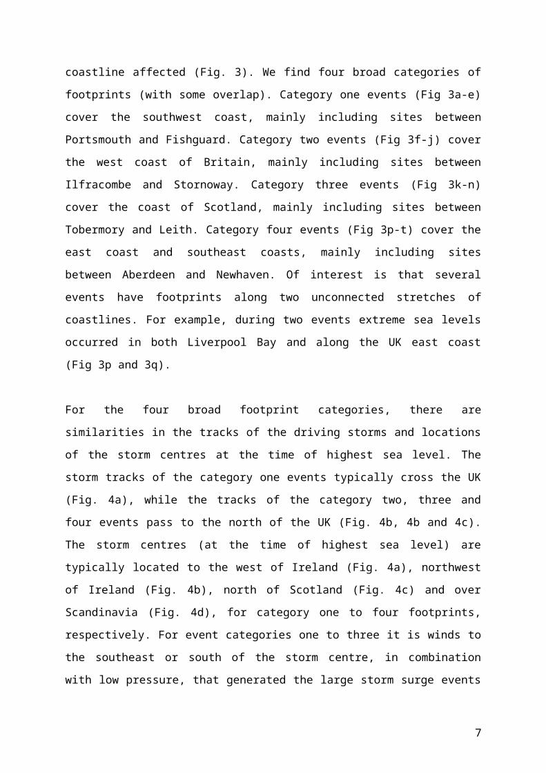
different spatial extents of coastline affected (Fig. 3). We find four broad categories of
footprints (with some overlap). Category one events (Fig 3a-e) cover the southwest coast,
mainly including sites between Portsmouth and Fishguard. Category two events (Fig 3f-j)
cover the west coast of Britain, mainly including sites between Ilfracombe and Stornoway.
Category three events (Fig 3k-n) cover the coast of Scotland, mainly including sites between
Tobermory and Leith. Category four events (Fig 3p-t) cover the east coast and southeast
coasts, mainly including sites between Aberdeen and Newhaven. Of interest is that several
events have footprints along two unconnected stretches of coastlines. For example, during two
events extreme sea levels occurred in both Liverpool Bay and along the UK east coast (Fig 3p
and 3q).
For the four broad footprint categories, there are similarities in the tracks of the driving storms
and locations of the storm centres at the time of highest sea level. The storm tracks of the
category one events typically cross the UK (Fig. 4a), while the tracks of the category two,
three and four events pass to the north of the UK (Fig. 4b, 4b and 4c). The storm centres (at
the time of highest sea level) are typically located to the west of Ireland (Fig. 4a), northwest
of Ireland (Fig. 4b), north of Scotland (Fig. 4c) and over Scandinavia (Fig. 4d), for category
one to four footprints, respectively. For event categories one to three it is winds to the
southeast or south of the storm centre, in combination with low pressure, that generated the
large storm surge events along the southwest, west and north coastlines (Supplementary Fig.
2a-2n). For event category four, it was mostly northerly winds behind the storm centre once it
passes into Scandinavia that generated the elevated sea levels in the North Sea
(Supplementary Fig. 2p-2t).
4

Distinct storm tracks are also observed for individual sites (Supplementary Fig. 3). There is a
clear northward shift in the average position of storm tracks moving from Newhaven (Site 1)
to Wick (Site 30), and then a southward shift of tracks moving from Wick down to Dover
(Site 40). Moving from sites 1 to 40, there is a clockwise rotation around the UK in the
location of the storm centre at time of maximum sea level (Supplementary Fig. 4).
We also observed four comparable broad categories in the footprints of the skew surge events
and corresponding similarities in the tracks of their driving storms (Supplementary Fig. 5 and
6). What is striking, however, is that the storms that generated the skew surge events follow a
much tighter path across the UK (Supplementary Fig. 7). The location of the storm centre, at
the time of maximum skew surge, is also closer to the UK (Supplementary Fig. 4b),
particularly for sites on the south and west coasts. This again emphasises that extreme sea
level events are mostly generated by moderate rather than extreme skew surges, combined
with larger astronomical tides.
Temporal AnalysisThird we examine the temporal variation in events. All of the extreme sea level events
occurred between August and April of the following year (Fig. 5a). The large number of
events in February, March, and October reflects the influence of astronomical tides, which are
largest around the time of the equinoxes36. The skew surge events all occurred between
September and March (Fig. 5b). This again demonstrates that extreme sea level events,
particularly those events occurring in April, August and September, are generated by
moderate skew surge events (including the 1 in 27 year extreme sea level event on 7 th April
1985). At seasonal and decadal scales there is considerable variation in the number of events
(Supplementary Fig. 8), but systematically comparing these over time is not possible because
of the incomplete data coverage (Fig. 2c).
We examine temporal clustering by considering the number of days between consecutive
events. There are seven pairs of sea level events (Fig. 6a) and 13 pairs of skew surge events
(Fig. 6b) that occurred within a period of less than four days. Due to lower data coverage in
the early part of the record (especially pre-1965), it is likely that the time between consecutive
events is overestimated on occasion, because we are missing events. Interestingly, there are
no instances of sea level events happening within 4-8 days of each other, whereas there are
5

occasions when pairs of skew surge events occurred within that time interval (Supplementary
Fig. 9). Importantly, the pairs of events that occurred in close succession (< 4 days) mostly
impact different sites and stretches of coastline (Fig. 7).
The unusual 2013/14 SeasonFinally we consider how unusual the 2013/14 season was in the context of the last 100 years,
from an extreme sea level and skew surge perspective. Across the 40 study sites, the storms
during the winter seasons of 2013/14 generated: (1) the maximum-recorded sea level (before
accounting for MSL rise) at 20 of the 40 sites; (2) the maximum-recorded sea level return
period (after removing MSL rise) at 16 of the 40 sites; and (3) the maximum observed skew
surges at 15 of the 40 sites (Supplementary Tables 4 and 5). From an event perspective, the
2013/14 season had: (1) the largest number of extreme sea level and skew surge events – there
were almost twice as many skew surge events than in any other season; (2) five occasions in
the top 10 largest spatial event footprints; and (3) two instances in the top 10 of the closest
inter-event time spacing between events. The seven sea level events in the 2013/14 season all
exceeded the 1 in 10 year return level and were in the top 50 events (Supplementary Table 2).
The season with the next largest number of extreme sea level events was 1994/95, during
which five events exceeded the 1 in 7 year return level, but the ranking of the events was
much lower. Four out of 11 skew surge events in the 2013/14 season ranked in the top 20
events, and seven in the top 35 events. The season with the next largest number of extreme
skew surge events was 1992/93 with six events, two in the top 20 events. These results
suggest that the 2013/14 season was an outlier in the last 100 years. However, it is difficult to
quantify this with high statistical certainty because of the reduced spatial coverage in tide
gauge sites, and hence incomplete records, especially prior to the 1960s.
DiscussionWe have used observational data to understand actual spatial extents and temporal sequences
of extreme sea level and skew surge events around the UK coast over the last 100 years. A
key finding is that the vast majority (86%) of the extreme sea level events were generated by
moderate, rather than extreme skew surges, combined with high spring tides. The dominant
influence of the astronomical tidal component upon observed sea levels is highlighted by the
fact that the spatial variation in maximum sea levels around the coast closely resembles the
variation in tidal range in most areas (Supplementary Fig. 10).
6
Using a simple qualitative approach, Zong and Tooley37 distinguished three main pathways of
storm tracks and three corresponding coastal sectors around the UK influenced by coastal
flooding. Our quantitative analysis here identified that there are four main storm track
pathways and four broad corresponding footprints of sea level events. These footprints could
be used to inform flood management, the insurance sector, and national emergency and
infrastructure resilience planning38,23. For example, they could be used to assess the likelihood
of multiple port failures during the same storm, and thus explore the key national
vulnerabilities in the UK port sector and related transport links and supply chains21. They
could also be used to facilitate a more intelligent spatial treatment of extreme sea level
scenarios, rather than assuming a simultaneous and unrealistic 1 in 1000-year return period
event, for example, everywhere around the UK coast.
Importantly, we identified that there have been occasional events, when extreme levels have
occurred along large lengths of coast and even along two unconnected stretches of coastlines
during the same event. This also has important implications for national emergency
preparedness and response and resilience planning. Extreme sea levels and flooding occurred
along two unconnected stretches of coast during the recent storm Xaver on 5-6/12/2013.
Examining the meteorological conditions and the track of the driving storm (Supplementary
Fig. 11), it is readily apparent why extreme sea levels occurred along two unconnected
stretches of coast. Wadey et al.21 highlighted that one key difference between this event and
the major 1953 event was that the former resulted in flooding in northwest England, as well as
along the east (North Sea) and south (English Channel) coasts, whereas the 1953 extreme sea
level and flood event appears to have been restricted to the east coast (but the data is more
limited in 1953, hindering a more direct comparison).
Clustering of storms is an important issue as it can lead, through compounding effects, to
large socioeconomic impacts and cumulative insurance losses32,29. Several studies30,31,32, have
recently investigated the mechanisms responsible for generating sequences of storms over
short periods. From the available data we identified seven pairs of extreme sea level events
and 13 pairs of extreme skew surge events that occurred within four days of each other. From
a flood risk perspective, a crucial finding is that these close succession events typically
impacted different sites and stretches of coastline. This is because the two storms did not
follow the same path, but rather deviated to the north or south of each other. Interestingly, we
7

found no recorded instances of extreme sea level events happening within 4-8 days of each
other. This is because if storms are separated by 4-8 days, one will always occur during neap
tide, and the combined sea level, even with a large storm surge, is unlikely to be high enough
to lead to extreme levels (we are aware of one exception - during the St Jude storm in October
2013 flooding occurred on a neap tide and this appeared to be due to an unusual
meteorological tsunami39). We hypothesize that where tidal ranges are small, such as in the
Mediterranean or Baltic Sea, the 4-8 day gap may not be as apparent.
The winter of 2013/14 set records for precipitation totals and the occurrence of extreme wind
speeds and experienced the most severe storminess for at least the last 143 years17. In regard
to extreme sea levels, our results suggest that the 2013/14 season was also exceptional. Since
1915, no season had this number of large extreme sea level and skew surge events. Our
analysis is, however, limited by the lack of data going back in time. In a complimentary study
we are undertaking a comprehensive review of a variety of ‘soft’ data sources (i.e.
unpublished reports, newspaper stories), to see if there is anecdotal evidence of any other
season (particularly earlier in the period) when so many events led to coastal flooding
(however, this analysis is also influenced by changes to defences over time, which complicate
the interpretation40). Building on our earlier study33, we have reviewed a wide range of
relevant sources41,37,42,40,43,44,45. Initial results suggest that no other season in the last 100 years
had the number and magnitude of coastal flooding events as seen in the 2013/14 season.
The possible climatological drives of this exceptional season have been discussed in detail in
Slingo et al.46, Huntingford et al.16 and Wild et al.47. In short, the UK’s wet and storm winter
was linked to record low temperatures on the North American continent48, and the contrast
between the warm tropical Atlantic and cold air advecting south across the United States are
likely to have been partly responsible for the persistence and unusual strength of the North
Atlantic jet stream, which created the ideal conditions for generation of storms. Huntingford
et al.16 argue that this in turn could have been related to the filling of the Aleutian Low in the
northeast Pacific, which itself could be linked to high sea surface temperatures and a
westward displacement of precipitation in the tropical Pacific. They also acknowledge the
possible influence of the tropical stratosphere and the potential for Arctic sea ice extent and
solar activity to affect the climate of the UK. Kendon and McCarthy48 stress the need for
further research to better understand the drivers of extreme UK winters and, due to their rare
nature and high impact, how they may be affected by climate change.
8

Herein we have pioneered what we call an ‘Event Analysis’ approach. Most past studies of
extreme sea levels have analyzed records from different sites individually. Studies that have
assessed the spatial nature of events have typically done this by considering secondary
parameters49,50 (e.g. the shape parameter of an extreme value distribution), rather than the
actual levels among sites. Studies that have compared levels across sites have tended to focus
on a limited (<5) number of events10,51 ,21. In contrast we have investigated the characteristics
of ~100 events across multiple sites. Our two-staged approach to identify events (see
Methods) allowed us to examine a particular event or site, or multiple events or sites, making
for a flexible and multifaceted analysis.
We investigated two types of events: (1) extreme sea level events; and (2) extreme skew
surges. Extreme sea level events directly lead to the exceedance of critical thresholds and
hence are the primary dataset that should be analysed when assessing flooding. However,
analyses of skew surge events are also useful, as they provide information on ‘near misses’.
As we have shown, some of the skew surge events coincided with the extreme sea level
events, when the storm surge occurred around the time of high water of a spring tide; most did
not coincide, because the surge occurred near low tide or on a neap tide. Had several of the
larger skew surge events occurred on a high spring tide, they would have resulted in higher
extreme sea levels than have been observed in the last 100 years. In addition, skew surge
time-series are more appropriate proxies for the inter-annual, multi-decadal and longer-term
changes in ‘storminess’ and the links to regional climate, compared to extreme sea level time-
series that are also influenced by astronomical tides.
The main limitation of our study (and most studies of natural hazards) is the significant
decline in data availability going back in time. As we outlined in Haigh et al.33, there are
several ways we could, and plan to, address the issue of missing events and hence the under-
or over-estimation of the parameters of interest. In the future we plan to include additional
tide-gauge records that do not form part of the National Network (such as at Southampton
where a record has been extended back to 193552). We also plan to supplement the database
with heights of sea level recorded in older journal papers and reports (or even flood markers
on buildings). Wadey et al.21 did this for the 1953 flood event, but this was a time-consuming
task, requiring meticulous examination of the data, and uncertainties still remain. Finally, we
9

plan to use sea level predictions from a multi-decadal simulated model hindcast, such as used
in various other studies53,54,55,56,57,58,.
Waves are also an important component of flooding around the UK coast, which we plan to
include in future analyses40.
We deliberately removed the influence of MSL, to directly compare the magnitude of events
throughout the period analysed. Consistent with other studies59,52, when we consider MSL, the
number of occurrences of extremes has increased over the last 100 years due to MSL rise and
this is expected to continue and accelerate.
Finally, our analysis has focused on the UK coastline, but storm surges and coastal flooding
are not limited to national borders during an event. Several of the larger events, such as 31 st
January – 1st February 1953 and 5th – 6th December 201321,60, have impacted other countries in
northern Europe. Our analysis could be extended to include tide gauge records from other
countries to assess the wider spatial footprint of events.
In summary, we have introduced a novel ‘Event Analysis’ approach and used it to assess
spatial footprints and temporal clustering of extreme events. Our results have provided
important new insights into various aspects of extreme sea level and skew surge events
around the UK coast that will improve the ways in which coastal flood risk is identified,
assessed and managed. Ongoing investment in the national network of tide gauges and
archaeology of historic analogue records52 is crucial to continue to provide the datasets upon
which our analyses are based. The methods that we developed and implemented can be easily
transferred to improve understanding of extreme events in other regions of the world where
suitable data exists.
10

MethodsThe three main data sources we utilized, and the methods we applied to identify extreme sea
level and skew surge events in the SurgeWatch database (Data Citation 1), are described in
detail by Haigh et al.33. We therefore provide only a brief overview here, but direct readers to
Haigh et al.33 for a more comprehensive account.
DataThe primary dataset we use comprises sea level records from the UK National Tide Gauge
Network (Data Citation 2). This network currently consists of 43 operational ‘A-class’ tide
gauges. It was setup after the 1953 flood event and is owned by the Environment Agency
(EA). The network underpins the UK Coastal Monitoring and Forecasting service and is
therefore maintained to a high standard. We downloaded the data from the British
Oceanographic Data Centre (BODC), who are responsible for the remote monitoring,
retrieval, quality-control and archiving of the data. We used data from 40 of the network’s
tide gauges (Fig. 1a, Supplementary Table 1). Three sites (Bangor and Portrush in Northern
Ireland and Jersey in the Channel Islands) were omitted, because the exceedance probabilities
(see description of second type of data below) used to assign return periods to high waters are
currently only available for England, Scotland and Wales. The mean data length for all
considered records is 38 years (Fig. 1b). We excluded all values which the BODC had flagged
as suspect and also undertook our own extensive checks. The frequency of the records
changed from hourly to 15-minutes after 1993. We deliberately did not interpolate the data
prior to 1993 to 15-minute resolution so that the values could be exactly matched back to the
original records.
The second dataset we use is exceedance probabilities from an EA study34,50. That study is the
most recent in a number of related UK investigations from the last six decades (see Haigh et
al.61 for a summary) and provides the latest still water level return period estimates around the
coastline of England, Scotland and Wales. We extracted the return levels for 16 return periods
(from 1 in 1 to 1 in 10,000 years), for each of the 40 tide gauge sites, using information listed
in Table 4.1 of McMillian et al.34. By linearly interpolating these 16 return periods, at each
site, we estimated the return periods of each extracted high water and identified those that
reached or exceeded the 1 in 5 year return level.
11

We use a third dataset of gridded mean sea level pressure and near-surface wind fields to: (1)
identify distinct extra-tropical storms that produced the extreme sea levels and skew surges
events; and (2) to capture the meteorological information from those storms. We used data
from the 20th Century global meteorological Reanalysis, Version 262 (Data Citation 3), which
has a spatial and temporal resolution of 2 degrees and 6 hours, respectively.
Analysis approachFor all 40 tide gauges we extracted extreme sea levels and skew surges that reached or
exceeded the 1 in 5 year return levels. Extreme sea levels arise as a combination of three main
factors: astronomical tide, storm surge and mean sea level (MSL)36 (waves can further elevate
sea levels, but their effect has not been considered here). We remove the influence of MSL, to
directly compare the magnitude of events throughout the period analysed. Many past studies
of storm surges in the UK63,49 ,64,65 ,66 have focused on analysing the non-tidal residual – the
component that remains once the astronomical tidal component has been removed from the
measured sea level record (Fig. 2). The non-tidal residual primarily contains the
meteorological contribution termed the ‘surge’, but may also contain harmonic prediction
errors or timing errors, and non-linear interactions, which can be large in certain regions, such
as the southern North Sea66. It is for this reason that we focused our analysis on skew surge,
and didn’t use the non-tidal residual. A skew surge is the difference between the maximum
observed sea level and the maximum predicted (astronomical) tidal level regardless of their
timing during the tidal cycle (Fig. 2). Hence each tidal cycle has one high water value and one
associated skew surge value. The advantage of using the skew surge is that it is a simple and
unambiguous measure of the storm surge relevant to any predicted high water, and
operationally it defines the quantity that may lead to flooding.
Following Haigh et al.33 we identified the two types of events using a two-staged approach.
The first stage of our analysis was to establish when observed sea levels or skew surges
reached or exceeded the 1 in 5 year return level. Identifying the extreme sea level events
involved several steps. First, we separated the measured sea level at each of the 40 study sites
into tidal and non-tidal components, so that the skew surge could be calculated and the
relative contribution of the tide could later be identified. The tidal component was predicted
using the T-Tide harmonic analysis software67. A separate tidal analysis was undertaken for
each calendar year using the standard 67 tidal constituents. For years with less than 6 months
12

of data coverage, the tidal component was predicted using harmonic constituents estimated for
the nearest year with sufficient data. Second, we extracted all twice-daily measured and
predicted high water levels at each site, using a turning point approach68, and then calculated
skew surges from the measured and predicted high waters. Third, we offset the extracted high
waters by the rate of linear MSL rise observed at each site (see Haigh et al. 33 for details). We
use a linear MSL trend so that the inter-annual and multi-decadal variations in MSL, which
can influence extreme sea levels13,14 remain in the time-series. Note, at a few sites with short
records the estimated linear trend was unrealistic. In these instances we used a rate
interpolated between neighbouring sites with longer records. We offset by MSL to directly
compare the return periods of the high water events throughout the record, independently of
MSL change. The EA return periods are relative to a baseline level which corresponds to the
average sea level in the year 200834. At sites that have undergone a rise in MSL over the
duration of the record, sea levels before 2008 would have a higher return period, and lower
return period thereafter. Fourth, we linearly interpolated the EA exceedance probabilities and
then estimated the return period of every high water, after offsetting for MSL, so that we
could directly compare events throughout the record. Fifth, we stored information associated
with the measured high waters, at each of the 40 sites that were equal to or greater than the
offset 1 in 5-year return level threshold. For each offset high water that exceeded the
threshold we recorded the: (1) date-time of the measured high water; (2) offset return period;
(3) measured high water level; (4) predicted high water level; (5) skew surge; and (6) site
number (site numbers are listed in Supplementary Table 1 and shown in Fig. 1).
In the SurgeWatch database (Data Citation 1) we stored information about the top 20 skew
surges at each site33. Here we carried out similar steps to that outlined above (to identify the
extreme sea level events) to identify all skew surges that reached or exceeded the 1 in 5 year
threshold, so that we could directly compare these to the extreme sea level events identified.
The EA study34 did not calculate return periods for skew surges. Hence, we calculated our
own skew surge return periods for each site. To do this we applied the Peaks over Threshold
(POT) method, by fitting a Generalized Pareto distribution (GPD) to all the skew surges that
exceeded the 99.75th percentile, at each site in turn. We used a declustering algorithm to
ensure independent events. We tested the fit of the GPD distribution using Gringorten’s
plotting positions, and found that the GPD fitted the data well at all sites except Portsmouth.
The fit at Portsmouth is poor, because this site has a relatively short record (1991-2014), and
the largest skew surge value exceeds the second largest value by a large amount (40 cm); this
13

skews the upper tail of the distribution. Hence, at Portsmouth we estimated return periods by
fitting a Gumbel distribution to the annual maximum value of each year of data. This
provided a better fit to the data and gave return periods that were more comparable to the
neighboring sites. The skew surge return levels, at each of the 40 sites, are listed in
Supplementary Table 6 for 16 return periods. At each of the 40 sites we stored information
associated with the skew surges that were equal to or greater than the 1 in 5-year return level
threshold. For each skew surge that reached or exceeded the threshold, we recorded the: (1)
date-time of the skew surge; (2) return period; (3) skew surge; (4) measured high water level;
(5) predicted high water level; and (6) site number.
The second stage of the analysis was to identify the distinct, extra-tropical storms that
produced the extreme sea levels and skew surges that were identified in stage 1, and then to
capture the meteorological information about those storms. This involved a two stepped
procedure. First, using a simple ‘storm window’ approach, we found that the effect of most
storms that caused high sea levels or skew surges in the UK typically lasted up to about 3.5
days. We started with the high water of highest return period, and found all of the other high
waters that occurred within a window of 1 day and 18 h before or after that high water (i.e.,
3.5 days). We then assigned to these the event number 1. We set all high waters associated
with event 1 aside and moved on to the high water with the next highest return period, and so
on. Second, we manually used the meteorological data to determine if our above-described
procedure had correctly linked high waters to distinct storms. To do this we created an
interactive interface in Matlab that displayed the 6-hourly progression of mean sea level
pressure and wind vectors over the North Atlantic Ocean and Northern Europe around the
time of maximum sea level. On most occasions our simple procedure correctly identified
distinct storms. On occasions that it did not (e.g. when examination of the meteorological
conditions showed that there were two distinct storms that crossed the UK in this period in
close succession; or when our simple procedure identified two events, whereas there was
actually only one event, associated with a particularly slow moving storm), we manually
separated the high waters into two distinct events, or combined them into one event, and
altered the event numbers accordingly. We repeated the procedure for the skew surges.
Using our interactive Matlab interface, we digitized the tracks of all storms that led to the
extreme sea level and skew surge events, starting when the low-pressure systems developed,
until they dissipated or moved beyond latitude 20°E. We captured the storm tracks by
14

selecting the grid point of lowest atmospheric pressure at each 6-hour time step. From the
start to the end of the storm we recorded the 6-hourly: (1) time; (2) latitude; and (3) longitude
of the minimum pressure cell; and (4) the minimum mean sea level pressure.
We used the 20th Century Reanalysis because it covers the full 100-year period (i.e. 1915-
2014) analysed. It is well known that reanalysis products are prone to inhomogeneities, due to
changes in the observing system, and these could influence our storm tracks, particularly
earlier in the period assessed69,70. However, it is encouragingly that even for events early in the
19th century, a storm was always evident in the reanalysis dataset at the exact time of the
extracted extreme sea level or skew surge events. Further, the storm centre, at time of
maximum sea level or skew surge was located in the expected region for that event (i.e. to the
west of the UK for events that affected the south and west coasts and to the east of the UK for
events that affected the east coast). Dangendorf et al.71 showed that the 20th Century
Reanalysis data have a high predictive skill back to the 1910s for the North Sea Region.
Further work could assess the difference in storm tracks obtained using a range of reanalysis
products and multiple ensemble members within reanlayses. We also recommend that these
sorts of studies be updated regularly using the latest reanalysis datasets available.
15

References1. RMS. Hurricane Katrina: Profile of a Super Cat, Lessons and Implications for
Catastrophe. Risk Management Solutions. http://forms2.rms.com/rs/729-DJX-
565/images/tc_2005_hurricane_katrina_lessons_implications.pdf (2005).
2. Jonkman, S. N., Maaskant, B., Boyd, E. & Levitan, M. L. Loss of Life Caused by
the Flooding of New Orleans After Hurricane Katrina: Analysis of the
Relationship Between Flood Characteristics and Mortality. Risk Analysis 29, 676–
698 (2009).
3. Nicholls, R. J., Reeder, T., Brown, S. & Haigh, I. D. The risks of sea-level rise for
coastal cities. In, King, D., Schrag, D., Dadi, Z., Ye, Q. and Ghosh, A. (eds.)
Climate change: a risk assessment. London, GB, Foreign and Commonwealth
Office, 94-98. (2015).
4. Fritz, H. M., Blount, C. D., Thwin, S., Thu, M. K. & Chan, N. Cyclone Nargis
storm surge in Myanmar. Nature Geoscience 2, 448–449 (2009).
5. Neria, Y. & Shultz, J. M. Mental Health Effects of Hurricane Sandy:
Characteristics, Potential Aftermath, and Response. JAMA 308, 2571–2572
(2012).
6. LeComte, D. International Weather Highlights 2013: Super Typhoon Haiyan,
Super Heat in Australia and China, a Long Winter in Europe. Weatherwise 67, 20–
27 (2014).
7. Haigh, I. D. et al. Timescales for detecting a significant acceleration in sea level
rise. Nature Communications 5, 3635 (2014).
8. Seneviratne, S.I., N. Nicholls, D. Easterling, C.M. Goodess, S. Kanae, J. Kossin,
Y. Luo, J. Marengo, K. McInnes, M. Rahimi,
M. Reichstein, A. Sorteberg, C. Vera, and X. Zhang. Changes in climate extremes
and their impacts on the natural physical environment. In: Managing the Risks of
Extreme Events and Disasters to Advance Climate Change Adaptation [Field,
C.B., V. Barros, T.F. Stocker, D. Qin, D.J. Dokken, K.L. Ebi, M.D. Mastrandrea,
K.J. Mach, G.-K. Plattner, S.K. Allen,
M. Tignor, and P.M. Midgley (eds.)]. A Special Report of Working Groups I and
II of the Intergovernmental Panel on Climate Change (IPCC). Cambridge
University Press, Cambridge, UK, and New York, NY, USA, pp. 109-230 (2012).
16
9. Mawdsley, R. J., Haigh, I. D. & Wells, N. C. Global secular changes in different
tidal high water, low water and range levels. Earths Future 3, 66–81 (2015).
10. Haigh, I. D., Nicholls, R. J. & Wells, N. C. Rising sea levels in the English
Channel 1900 to 2100. Proceedings of the ICE - Maritime Engineering 164, 81–92
(2011).
11. Menéndez, M. & Woodworth, P. L. Changes in extreme high water levels based
on a quasi‐global tide‐gauge data set. Journal of Geophysical Research: Oceans
115, C10011 (2010).
12. Hunter, J. A simple technique for estimating an allowance for uncertain sea-level
rise. Climatic Change 113, 239–252 (2012).
13. Marcos, M., Calafat, F. M., Berihuete, Á. & Dangendorf, S. Long‐term variations
in global sea level extremes. Journal of Geophysical Research: Oceans 120, 8115–
8134 (2015).
14. Mawdsley, R. J. & Haigh, I. D. Spatial and Temporal Variability and Long-Term
Trends in Skew Surges Globally. Front. Mar. Sci. 3, 277 (2016).
15. Hallegatte, S., Green, C., Nicholls, R. J. & Corfee-Morlot, J. Future flood losses in
major coastal cities. Nature Clim. Change 3, 802–806 (2013).
16. Huntingford, C. et al. Potential influences on the United Kingdom's floods of
winter 2013/14. Nature Clim. Change 4, 769–777 (2014).
17. Matthews, T., Murphy, C., Wilby, R. L. & Harrigan, S. Stormiest winter on record
for Ireland and UK. Nature Clim. Change 4, 738–740 (2014).
18. Thorne, C. Geographies of UK flooding in 2013/4. The Geographical Journal 180,
297–309 (2014).
19. Sibley, A., Cox, D. & Titley, H. Coastal flooding in England and Wales from
Atlantic and North Sea storms during the 2013/2014 winter. Weather 70, 62–70
(2015).
20. Spencer, T., Brooks, S. M., Evans, B. R., Tempest, J. A. & Möller, I. Southern
North Sea storm surge event of 5 December 2013: Water levels, waves and coastal
impacts. Earth-Science Reviews 146, 120–145 (2015).
21. Wadey, M. et al. A comparison of the 31 January–1 February 1953 and 5–6
December 2013 coastal flood events around the UK. Front. Mar. Sci. 2, 84 (2015).
22. Wadey, M. P., Haigh, I. D. & Brown, J. M. A century of sea level data and the
UK's 2013/14 storm surges: an assessment of extremes and clustering using the
Newlyn tide gauge record. Ocean Sci. 10, 1031–1045 (2014).
17

23. Achuthan, A., Roan, J. & Fujiyama, T. Resilience of the food supply to port
flooding on east coast. (DEFRA, 2015).
24. Hall, J. W., Tran, M., Hickford, A. J. & Nicholls, R. J. The Future of National
Infrastructure. (Cambridge University Press, 2016).
25. Wadey, M., Brown, J., Haigh, I. & Dolphin, T. Assessment and comparison of
extreme sea levels and waves during the 2013/2014 storm season in two UK
coastal regions. Nat. Hazards Earth Syst. Sci. 15, 2209–2225 (2015).
26. Karunarathna, H., Pender, D., Ranasinghe, R., Short, A. D. & Reeve, D. E. The
effects of storm clustering on beach profile variability. Marine Geology 348, 103–
112 (2014).
27. Mandelbrot, B. B. How long is the coast of Britain. Science 156, 636–638 (1967).
28. Weiss, J., Bernardara, P. & Benoit, M. Modeling intersite dependence for regional
frequency analysis of extreme marine events. Water Resources Research 50,
5926–5940 (2014).
29. Mailier, P. J. et al. Serial Clustering of Extratropical Cyclones. Monthly Weather
Review 134, 2224–2240 (2010).
30. Vitolo, R., Stephenson, D. B., Cook, I. M. & Mitchell-Wallace, K. Serial
clustering of intense European storms. Meteorol. Z. 18, 411–424 (2009).
31. Villarini, G., Smith, J. A., Vitolo, R. & Stephenson, D. B. On the temporal
clustering of US floods and its relationship to climate teleconnection patterns.
International Journal of Climatology 33, 629–640 (2013).
32. Pinto, J. G., Bellenbaum, N., Karremann, M. K. & Marta, Della, P. M. Serial
clustering of extratropical cyclones over the North Atlantic and Europe under
recent and future climate conditions. Journal of Geophysical Research:
Atmospheres 118, 12,476–12,485 (2013).
33. Haigh, I. D. et al. A user-friendly database of coastal flooding in the United
Kingdom from 1915–2014. Scientific Data 2, 150021 (2015).
34. McMillian, A. et al. Coastal flood boundary conditions for UK mainland and
islands. 1–142 (Environment Agency, 2011).
35. Haigh, I. D., Eliot, M. & Pattiaratchi, C. Global influences of the 18.61 year nodal
cycle and 8.85 year cycle of lunar perigee on high tidal levels. Journal of
Geophysical Research: Oceans (1978–2012) 116, C06025 (2011).
36. Pugh, D. & Woodworth, P. Sea-level science: understanding tides, surges,
tsunamis and mean sea-level changes. (Cambridge University Press, 2014).
18
37. Zong, Y. & Tooley, M. J. A historical record of coastal floods in Britain:
Frequencies and associated storm tracks. Nat Hazards 29, 13–36 (2003).
38. Cabinet Office. National Risk Register of Civil Emergencies.
https://www.gov.uk/government/uploads/system/uploads/attachment_data/file/
419549/20150331_2015-NRR-WA_Final.pdf (Cabinet Office, 2015).
39. Ozsoy, O., Haigh, I. D., Wadey, M. P., Nicholls, R. J. & Wells, N. C. High-
frequency sea level variations and implications for coastal flooding: A case study
of the Solent, UK. Continental Shelf Research 122, 1–13 (2016).
40. Ruocco, A. C., Nicholls, R. J., Haigh, I. D. & Wadey, M. P. Reconstructing coastal
flood occurrence combining sea level and media sources: a case study of the
Solent, UK since 1935. 59, 1773–1796 (2011).
41. Davison, M., Currie, I. & Ogley, B. The Hampshire and Isle of Wight Weather
Book. (Froglets Publications Ltd, 1993).
42. Eden, P. Great British Weather Disasters. (A&C Black, 2008).
43. Kundzewicz, Z. W., Pińskwar, I. & Brakenridge, G. R. Large floods in Europe,
1985–2009. Hydrological Sciences Journal 58, 1–7 (2013).
44. Stevens, A. J., Clarke, D. & Nicholls, R. J. Trends in reported flooding in the UK:
1884–2013. Hydrological Sciences Journal 61, 50–63 (2015).
45. Hickey, K. L. Documentary records of coastal storms in Scotland, 1500-1991 A.D.
(Coventry University. 1997).
46. Slingo, J. et al. The recent storms and floods in the UK.
http://www.metoffice.gov.uk/media/pdf/n/i/Recent_Storms_Briefing_Final_07023
.pdf (Met Office, 2014).
47. Haigh, I. D., Nicholls, R. & Wells, N. A comparison of the main methods for
estimating probabilities of extreme still water levels. Coastal Engineering 57, 838–
849 (2010).
48. Kendon, M. & McCarthy, M. The UK’s wet and stormy winter of 2013/2014.
Weather 70, 40–47 (2015).
49. Dixon, M. J. & Tawn, J. A. Estimates of extreme sea conditions – Final report,
spatial analysis for the UK coast.
http://www.ntslf.org/sites/ntslf/files/pdf/other_reports/id112.pdf (1997).
50. Batstone, C. et al. A UK best-practice approach for extreme sea-level analysis
along complex topographic coastlines. Ocean Engineering 71, 28–39 (2013).
19

51. Wadey, M. P., Nicholls, R. J. & Haigh, I. D. Understanding a coastal flood event:
the 10th March 2008 storm surge event in the Solent, UK. Natural Hazards, 67,
829–854 (2013).
52. Haigh, I. D., Nicholls, R. & Wells, N. Mean sea level trends around the English
Channel over the 20th century and their wider context. Continental Shelf Research
29, 2083–2098 (2009).
53. Weisse, R. & Plüβ, A. Storm-related sea level variations along the North Sea coast
as simulated by a high-resolution model 1958–2002. Ocean Dynamics 56, 16–25
(2005).
54. Bernier, N. B. & Thompson, K. R. Predicting the frequency of storm surges and
extreme sea levels in the northwest Atlantic. J. Geophys. Res. 111, C10009 (2006).
55. Sebastião, P., Guedes Soares, C. & Alvarez, E. 44 years hindcast of sea level in the
Atlantic Coast of Europe. Coastal Engineering 55, 843–848 (2008).
56. Haigh, I. D. et al. Estimating present day extreme water level exceedance
probabilities around the coastline of Australia: tides, extra-tropical storm surges
and mean sea level. Clim Dyn 42, 121–138 (2014).
57. Haigh, I. D. et al. Estimating present day extreme water level exceedance
probabilities around the coastline of Australia: tropical cyclone-induced storm
surges. Clim Dyn 42, 139–157 (2014).
58. Arns, A., Wahl, T., Haigh, I. D. & Jensen, J. Determining return water levels at
ungauged coastal sites: a case study for northern Germany. Ocean Dynamics 65,
539–554 (2015).
59. Ezer, T. & Atkinson, L. P. Accelerated flooding along the U.S. East Coast: On the
impact of sea-level rise, tides, storms, the Gulf Stream, and the North Atlantic
Oscillations. Earths Future 2, 362–382 (2014).
60. Dangendorf, S., Arns, A., Pinto, J. G., Ludwig, P. & Jensen, J. The exceptional
influence of storm ‘Xaver’ on design water levels in the German Bight. Environ.
Res. Lett. 11, 054001 (2016).
61. Haigh, I. D., Nicholls, R. & Wells, N. A comparison of the main methods for
estimating probabilities of extreme still water levels. Coastal Engineering 57, 838–
849 (2010).
62. Compo, G. P. et al. The Twentieth Century Reanalysis Project. Quarterly Journal
of the Royal Meteorological Society 137, 1–28 (2011).
20
63. Tawn, J. A. Extreme sea levels: the joint probabilities method revisited and
revised. Proceedings of the Institution of Civil Engineers (London). Part 1 -
Design & Construction 87, 429–442 (1989).
64. Butler, A., Heffernan, J. E., Tawn, J. A., Flather, R. A. & Horsburgh, K. J.
Extreme value analysis of decadal variations in storm surge elevations. Journal of
Marine Systems 67, 189–200 (2007).
65. Haigh, I., Nicholls, R. & Wells, N. Assessing changes in extreme sea levels:
Application to the English Channel, 1900–2006. Continental Shelf Research 30,
1042–1055 (2010).
66. Horsburgh, K. J. & Wilson, C. Tide‐surge interaction and its role in the
distribution of surge residuals in the North Sea. Journal of Geophysical Research:
Oceans (1978–2012) 112, C08003 (2007).
67. Pawlowicz, R., Beardsley, B. & Lentz, S. Classical tidal harmonic analysis
including error estimates in MATLAB using T_TIDE. Computers & Geosciences
28, 929–937 (2002).
68. Woodworth, P. L., Shaw, S. M. & Blackman, D. L. Secular trends in mean tidal
range around the British Isles and along the adjacent European coastline.
Geophysical Journal International 104, 593–609 (1991).
69. Krueger, O., Schenk, F., Feser, F. & Weisse, R. Inconsistencies between Long-
Term Trends in Storminess Derived from the 20CR Reanalysis and Observations.
J. Climate 26, 868–874 (2013).
70. Wang, X. L. et al. Is the storminess in the Twentieth Century Reanalysis really
inconsistent with observations? A reply to the comment by Krueger et al. (2013b).
Clim Dyn 42, 1113–1125 (2013).
71. Dangendorf, S. et al. North Sea Storminess from a Novel Storm Surge Record
since AD 1843*. J. Climate 27, 3582–3595 (2014).
21

Data Citations1. Haigh, I. D. et al. British Oceanographic Data Centre http://dx.doi.org/10/zcm (2015).
2. UK Tide Gauge Network, British Oceanographic Data Centre
https://www.bodc.ac.uk/data/online_delivery/ntslf/ (2015).
3. The 20th Century Reanalysis (V2) Project
http://www.esrl.noaa.gov/psd/data/gridded/data.20thC_ReanV2.html (2015).
22
AcknowledgementsWe thank the British Oceanographic Data Centre (BODC) for providing the sea level data and
the Environment Agency (EA) for providing the sea level return period statistics. I.D.H,
M.P.W. and J.M.B were funded for this work through the Engineering and Physical Science
Research Council Flood Memory Project (grant number EP/K013513/1). T.W. has received
funding from the European Union’s Horizon 2020 research and innovation programme under
the Marie Sklodowska-Curie grant agreement No 658025.
Author ContributionsI.D.H, M.P.W and J.M.B had the initial idea for the analysis. The analysis was undertaken by
I.D.H and he drafted the initial version of the manuscript. All the authors shared ideas
regarding the analysis and contributed to this manuscript.
Competing interestsThe authors declare no competing financial interests.
Corresponding authorCorrespondence to I.D. Haigh – [email protected]
23

Figure 1: Tide gauge sites and duration(a) Location of tide gauge sites around the UK, with site number; and (b) duration of the sea level records.

Figure 2: Extreme sea level and skew surge events(a) Return period of the highest sea levels in each of the 96 sea level events, offset for mean sea level; (b) return period of the highest skew surges in each of the 111 skew surge events; (c) the number of sites per annum for which sea level data is available across the 40 sites; and (d) pie chart showing the number of skew surge events that led to sea level events (blue) and the number that did not (green). The grey shading in (a) and (b) indicates the number of sites for which data is available for each year – the lighter the grey the more sites for which data is available.
25

Figure 3: Spatial footprints of extreme sea level eventsThe spatial footprints of all the sea level events that impacted at least four tide gauge sites. The first number in the top left hand corner indicates the event ranking and the number in the bracket is the number of sites where the 1 in 5 year return level was reached or exceeded. The category one, two, three and four footprint events are shown in the first, second, third and fourth row of panels, respectively.
26

Figure 4: Storm tracks of extreme sea level events for different spatial footprintsThe tracks of the storms that generated the sea level events shown in Fig. 3 that impacted at least four tide gauge sites, for the four categories identified. The dots indicate where the storms centres were at time of highest sea level return period.
27
Figure 5: Seasonal distribution of extreme sea level and skew surge eventsNumber of (a) sea level and (b) skew surge events per month for different return level thresholds.
28

Figure 6: Temporal clustering of extreme sea level and skew surge eventsNumber of days between successive (a) sea level and (b) skew surge events. The grey shading indicates the number of sites for which data is available for each year – the lighter the grey the more sites for which data is available.
29

Figure 7: Spatial footprint of sea level events with the closest inter-event spacingThe spatial footprints of the seven pairs of sea level events that had the closest inter-event time spacing (0.9 to 3.1 day intervals). The first number in the top left hand corner indicates the event ranking and the number in the brackets is the number of sites where the 1 in 5 year return level was reached or exceeded.
30