welcome to the ideas fair - richmond, british · pdf filequadrant steveston park richmond...
TRANSCRIPT

London / Steveston Park
1
www.richmond.ca
Williams Road
Steveston Highway
No.
2 R
oad
Gilb
ert
Road
Open House
Proposed Study Area
The planning process for the redesign of the western part of London/Steveston Neighbourhood Park is underway.
This process will focus on the area of the park proposed to be transferred to the City as part of the rezoning application for the former Steveston School site at 10440 and 10460 No. 2 Road.
We invite you to participate by sharing your ideas and providing input toward the preparation of the park concept plan.
Ways to be involved:• Visit www.LetsTalkRichmond.ca after February
12 to learn more about the plans and provide comments
• Attend the series of drop-in style public open houses for one-on-one interaction with City staff, display boards, handouts and comment form.
The City of Richmond invites your input about London/Steveston Neighbourhood Park
Dates, Times and Agenda:
Thursday, Feburary 12 ...... 7:00 – 9:00 p.m...........Sharing ideasSaturday, February 14 ...... 1:00 – 3:00 p.m...........Sharing ideasThursday, March 5 ........... 7:00 – 9:00 p.m...........Reviewing concept optionsTuesday, March 31 ........... 7:00 – 9:00 p.m...........Preparing a preferred design
Place: The Gilbert Lounge, Steveston-London Secondary School, 6600 Williams Road
For more information, contact the Parks Department at 604-244-1208 or visit www.richmond.ca/parksprojects.
Welcome to the ideas fair...
Existing site photos - credit Clayton Perry (http://claytonperryphotography.tumblr.com/)

London / Steveston Park Background & Community
Steveston Hwy
site of rezoning application of former London-Steveston School site.
ErringtonNeighbourhood School
Richmond Christian School
James MckinneyElementary school
Major Roads
Major Street Bike Lane
Bus stops
Secondary Roads
Pedestrian / Circulation ALR
Park Lane Neighbourhood Park
Maple LaneNeighbourhood School
Gilb
ert
Rd
No
2 R
d
Neighbourhood Plan - Existing Connections
0
100
200
300
metres
0m
25m
50m
75m
Entry to Site
Site Boundary
Steveston-LondonSecondary School
Pedestrian Circulation
Flexible Open Space
Soccer Field
Soccer Field
Site of proposed development by Polygon Homes
Playground
Former School Field
SoftballSoftball
SoftballSoftball
Caretaker Buiding
No
2 R
dGoldsmith Dr
Williams Rd
Site Plan - Existing Spatial Uses, Connections, Vegetation.
Site Analysis
Stur
geon
Ban
ks
South Arm Fraser River
South A
rm Fr
aser R
iver
Mid
dle
Arm
Fra
ser
North Arm Fraser
VANCOUVER
BURNABY
DELTA
ANNACISISLAND
LADNER
Alaksen NationalWildlife Area
Reifel IslandBird Sanctuary
SwishwashIsland
Don Island
Lion Isl
and
Steveston (Shady) Island
Mitchell Island
Arthur LaingBridge
Oak StreetBridge
Knight StreetBridge
Alex FraserBridge
No. 2 Road Bridge
DinsmoreBridge
MorayChannelBridge
SeaIslandBridge
VancouverInternationalAirport
GARRY PT. PARK
HUGH BOYDPARK
BURNETTTHOMPSON
MINORUPARK
SOUTH ARMPARK / WHITESIDE
McCALLAN PARK
TERRA NOVA
TERRA NOVANATURAL AREA
TERRA NOVANORTHWESTQUADRANT
STEVESTON PARK
RICHMONDNATURE PARK
RICHMONDNATURE PARK
EAST
KING GEORGE/CAMBIE
FLIGHT PATHPARK
McDONALD BEACH PARK & BOAT LAUNCH
LONDON FARM
BRITANNIA HERITAGESHIPYARD
McLEANPARK
HAMILTONPARK
GARDENCITYPARK
IONA ISLANDREGIONAL PARK- GVRD
MCMATH
RICHMONDSTREET
LORD BYNG
T. HOMMA
BIKE TERRAIN PARK
COMMUNITYGARDEN SOUTH
CITY NURSERY
WESTWIND
McKINNEY
KOZIER
SANDIFORD
BRANSCOMBEHOUSE
DIEFENBAKER
STEVES
DIXON
WOWK
KILGOUR
BLUNDELL
PARKLANE
ERRINGTON
MAPLE LANE
BRIDGE
RIDEAU
PALMER /GARDEN CITY
WALTER LEE
HEATHER
DEBECK
McNAIR
KIDD
CRESTWOOD
KINGSWOOD
WOODWARD
LEE SLOUGH MODEL AIRPLANE PARK
AGASSIZ
FERRIS
MARRINGTONGILMORE
QUILCHENA
MORRIS
McKAY
GARRATT
SAMUELBRIGHOUSE
COOK
LANG
BRIGHOUSE
RICHMOND HIGH
GENERAL CURRIE
TOMSETT
KILBY
TALMEY
TAIT
BRIDGEPORTINDUSTRIAL LANDS
ALBERT AIREYMITCHELL
HONDAFIELD
NO. 7 ROAD PIER
NORTH EASTBOG FOREST
HAMILTONVLA
HAMILTONHIGHWAYPARK
CAMBIE FIELD
BURKEVILLE
SEA ISLAND SCHOOL
TEMPLETONFIELD
SEA ISLANDCOM. CENTRE
MILLER
ODLIN
ODLINWOOD
DOVER
TERRA NOVASOUTH
THOMPSON
GIBBONS VLA TIFFANY
SKATEBOARDPARK
GARNET
GRAUER
TOYOTAMINI PARK
FRASERWOODPARK
FEDORUK KARTNER
WOODWARD'SLANDING
GREAT WESTCANNERY PARK
LONDON STEVESTON
McNEILANDERSON
MCLENNANSOUTH
IMPERIAL LANDINGPARK
COMMUNITYGARDEN NORTH
4
5
6
8
910
11
12
13
7
312
15
16
17
18
19
20
21
2327
28
25
26
24
22
14
P P
P P
P
P
P
P
PP
P
P
P
P
P
P
P
PP
P
P
P
P
P
P
P
P
PP
P P
P
P
P
PP
P
P
P
P
P
P
P
P
P
DOG OFFLEASH AREA
Steveston Highway
Finn Road
Steveston Highway
Moncton Street
Chatham Street
7th A
venu
e
Williams Road
Blundell Road
Granville Avenue
Bridgeport Road
Cambie Road Cambie Road
Francis Road
Williams Road
Blundell Road
Francis Road
Westminster Hwy. Westminster Hwy.
Alderbridge Way
River Road
No. 2
Road
No. 1
Road
No. 1
Road
Railw
ay Av
enue
Railw
ay Av
enue
Gilbe
rt Ro
ad
No. 2
Road
Gilbe
rt Ro
ad
Shell
Road
Shell
Road
Shell
Road
No. 3
Road
No. 3
Road
Mino
ru Bl
vd.
No. 4
Road
No. 4
Road
Gard
en Ci
ty R
oad
No. 4
Road
Gard
en Ci
ty Ro
adGa
rden
City
Road
No. 5
Road
Hig
hway
99
Sidaw
ay Ro
ad
No. 6
Road
No. 5
Road
Sidaw
ay Ro
ad
No. 6
Road
No. 7
Road
No. 8
Road
Dyke Road
Highway 91
Highway 91
Nelso
n Roa
d
No. 8
Road
No. 9
Road
Gray
bar R
oad
Boun
dary
Road
Westm
inster
Hwy.
River Road
Russ Baker
Way
Tem
pleto
n Roa
d
Triangle R
oad
Dyke Road
Dyke Road
Grauer Road
Miller Road
Sea Island Way
VancouverInternationalAirport
River Road
Steveston Greenways
Finn Road Trail
HorseshoeSlough Trail
Wes
t Dyk
e Tr
ail
Wes
t Dyk
e Tr
ail
Shel
l Roa
d Tr
ail
Bath SloughTrail
BridgeportTrail
Middle ArmTrail
Middle Arm Trail
Queen's Canal Trail
South Dyke Trail
LEGEND: City of Richmond Recreation Areas: City Centre East Richmond Hamilton Sea Island South Arm Steveston Thompson West Richmond Other Municipalities Marsh / Wet Lands Parks Trail - Pedestrian / cyclist / wheel chair accessible Commuter Cycling Routes (Designated bike lanes)
Connector Routes School sites 1 km Distance Markers Trail Trail Names Community Centre Aquatic Centres / Outdoor Pools Ice Skating Arenas Dyke Trail Access Points Points of Interest Picnic Table Areas (2 or more picnic tables per site)
Outdoor Tennis Courts Basketball Courts Lacrosse Box/Ball Hockey Courts Parking Handicapped Accessible (Note: Trail surface may be unpaved, use caution)
Dogs O�-Leash Areas Trail Washroom Facilities
1
P
LEGEND:
Marsh / Wet Lands
Parks
Trail - Pedestrian / cyclist /
Commuter Cycling Routes
Connector Routes
School sites
1 km Distance Markers
Trail Trail Names
Community Centre
Aquatic Centres / Outdoor Pools
Ice Skating Arenas
Dyke Trail Access Points
Points of Interest
Picnic Table Areas
Outdoor Tennis Courts
Basketball Courts
Lacrosse Box/Ball Hockey Courts
Parking
Handicapped Accessible
P
Trail Washroom Facilities
Dog O�-Leash Areas
1
(designated bike lanes)
Wheelchair accessible
2 km (12 minutes walk)from the park
Community Plan
London-Steveston School
1 km (12 minutes walk)from the park
2
London / Steveston Park
3Background & Community
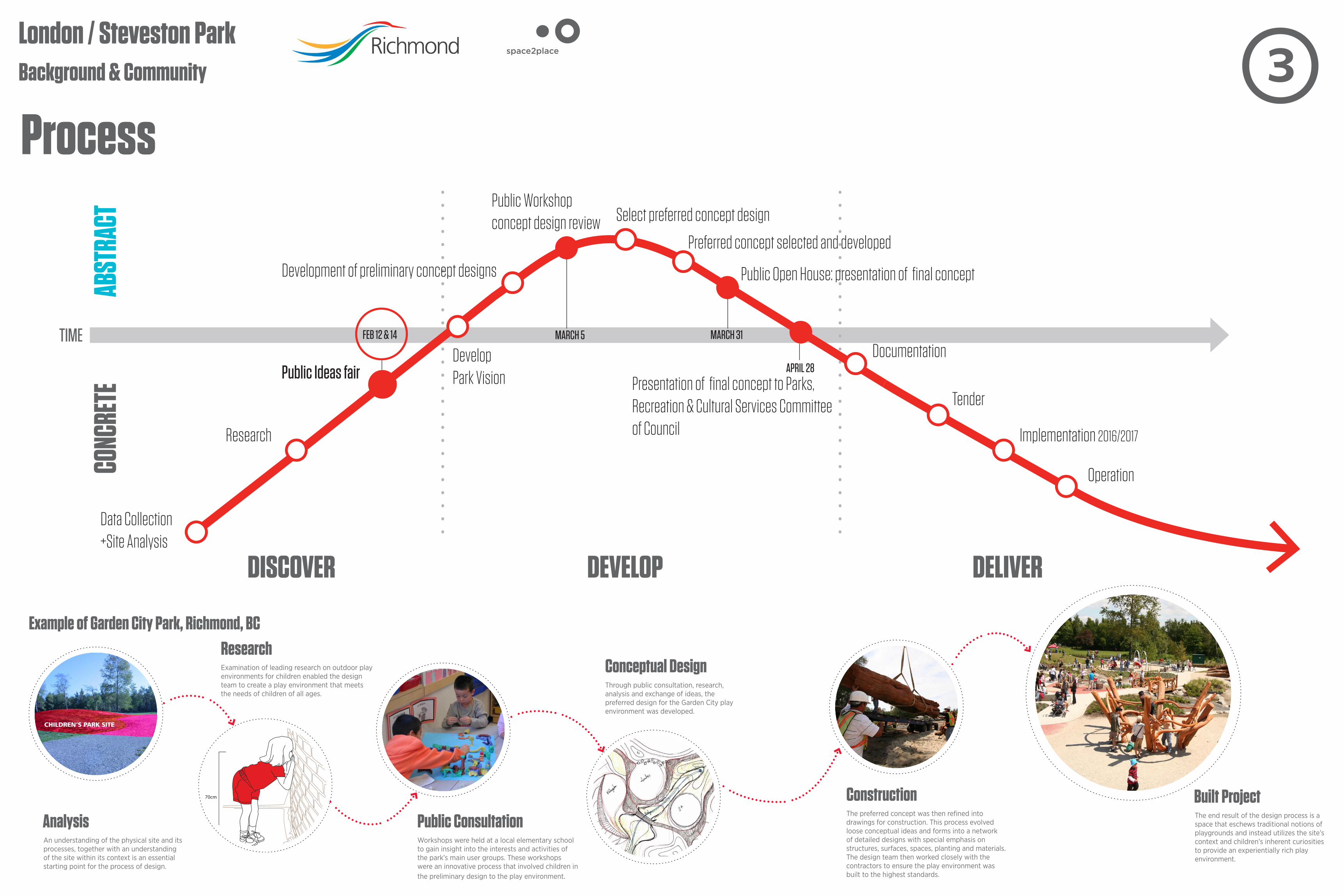
Process
Example of Garden City Park, Richmond, BC
AnalysisAn understanding of the physical site and its processes, together with an understanding of the site within its context is an essential starting point for the process of design.
ResearchExamination of leading research on outdoor play environments for children enabled the design team to create a play environment that meets the needs of children of all ages.
Public ConsultationWorkshops were held at a local elementary school to gain insight into the interests and activities of the park’s main user groups. These workshops were an innovative process that involved children in the preliminary design to the play environment.
Conceptual DesignThrough public consultation, research, analysis and exchange of ideas, the preferred design for the Garden City play environment was developed.
Built ProjectThe end result of the design process is a space that eschews traditional notions of playgrounds and instead utilizes the site’s context and children’s inherent curiosities to provide an experientially rich play environment.
70cm ConstructionThe preferred concept was then refined into drawings for construction. This process evolved loose conceptual ideas and forms into a network of detailed designs with special emphasis on structures, surfaces, spaces, planting and materials. The design team then worked closely with the contractors to ensure the play environment was built to the highest standards.
CONC
RETE
ABST
RACT
FEB 12 & 14 MARCH 5 MARCH 31
DISCOVER DEVELOP DELIVER
Data Collection+Site Analysis
Public Ideas fair
Research
Develop Park Vision
TIME
Public Workshopconcept design review Select preferred concept design
Preferred concept selected and developed
Public Open House: presentation of final concept
Documentation
Tender
Implementation 2016/2017
Operation
Development of preliminary concept designs
APRIL 28
Presentation of final concept to Parks, Recreation & Cultural Services Committee of Council

London / Steveston Park Tell us about the Park
I like the following qualities of the existing London-Steveston Park...
4

London / Steveston Park
If I could, I would change the following things about the park...
Tell us about the Park 5
London / Steveston Park future for the park / vision
The following is how I would decribe my vision for an ideal London / Steveston Park in 10 years...
6

London / Steveston Park
7Visual Explorer
Balance of uses within the Park redesign...
Organised Sports
Play Environment Social Amenities
Examples:Examples:
Examples:
London / Steveston Park
8
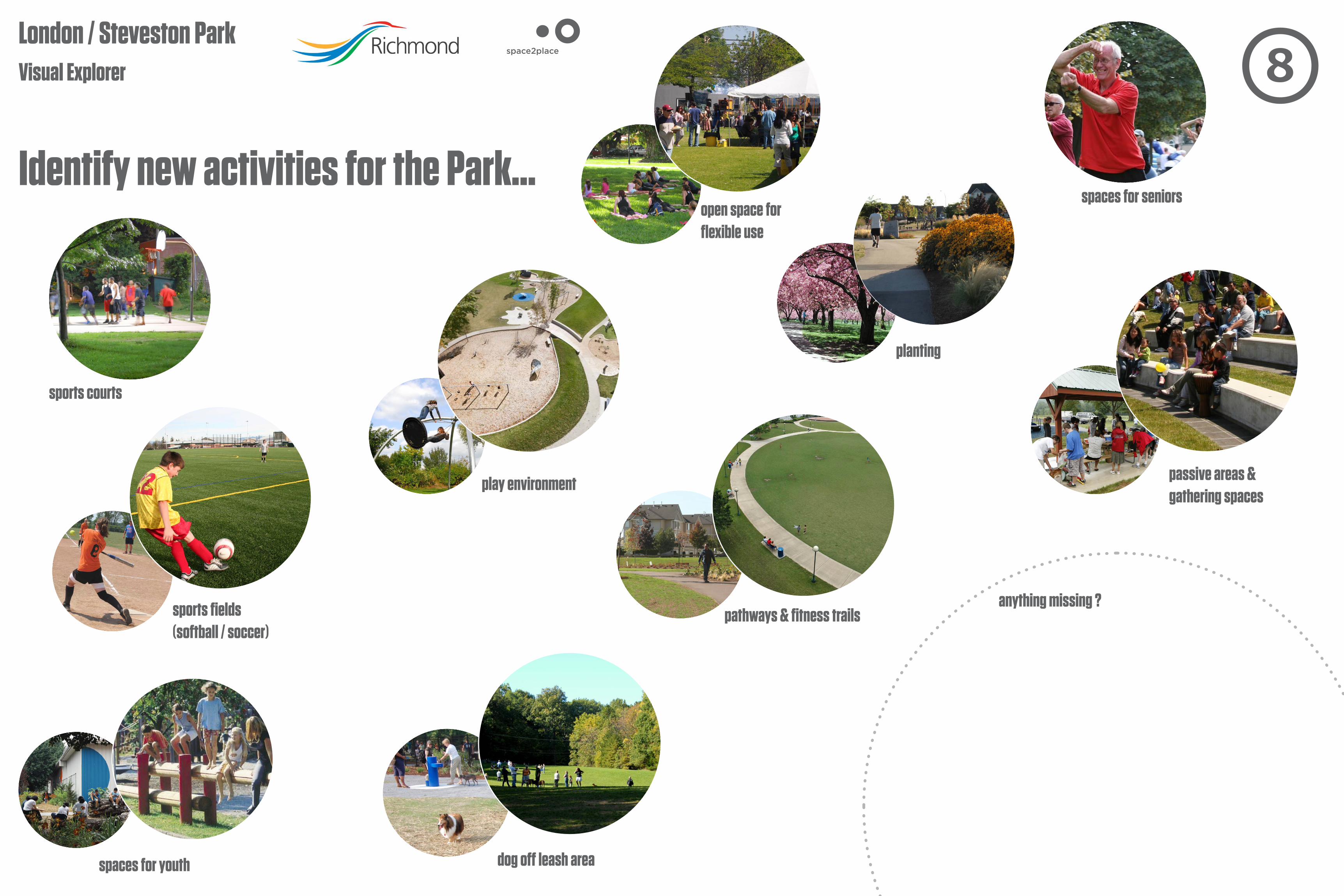
Visual Explorer
Identify new activities for the Park...
sports courts
dog off leash area
planting
spaces for seniors
spaces for youth
pathways & fitness trails
play environment
open space for flexible use
sports fields(softball / soccer)
passive areas & gathering spaces
anything missing ?