wellington city aerial imagery (2012) metadata
TRANSCRIPT
Metadata information for Geographic Information Systems Data Wellington City Council
Wellington City Aerial Imagery (2012) Metadata Name:
Wellington City Aerial Imagery (2012)
Abstract:
Wellington City orthophotography flown on the 17th January 2012.
Purpose of data:
Wellington City Council business.
Area of coverage:
Central Wellington, Mt Cook, Newtown and selected parts of Crofton Downs, Newlands, Johnsonville, Woodridge, Tawa, Kilbirnie and Owhiro Bay.
Date of capture / date created:
17 January 2012
Data type:
Raster
Native data format: Uncompressed Tiff / ESRI tfw
Update frequency:
Not updated
Positional accuracy:
+/- 0.3m (90% confidence level)
Accuracy statement:
Wellington City GIS data has been compiled from a number of sources and its accuracy may vary. This data is provided “as is” without warranty of any kind. The Wellington City Council recommends that you independently verify the accuracy, currency and reliability of any information upon which you intend to rely. The GIS data made available by Wellington City Council may be amended and updated by the Council without notification. There may be significant delays before data is updated to reflect changes in an area.
Image resolution / ground sample distance:
0.1m
Dataset history: Flown by NZ Aerial Mapping on behalf of Terralink International Ltd. Camera: UltraCam X. Scale: Approx 1:18,000. Altitude: Approx 5000 feet AMG. Lens: UCX = 100.5mm. Film Type: No Film – Digital camera used. Image Type: Intergraph JPEG compressed TIFF. Compression factor: Q4. Resolution: UCX – 7.2 micron. Terralink was able to utilise its existing database of Ground Control Points (GCPs) for this project which along with the WCC supplied GCPs and additional new GCPs acquired for the 2009 project, meant that no new Ground Control Points were required for this 2012 partial update.
Metadata information for Geographic Information Systems Data Wellington City Council
To see the coverage captured in this aerial project, refer to the Wellington City tile extent: Wellington City Ortho Tile Index NZTM 1 to 500.
Coordinate System: Horizontal Coordinate System: NZTM Geodetic Model: NZGD2000 Vertical Coordinate System: MSL (Wellington 1953)
License: Creative Commons Attribution 3.0 New Zealand
Additional Notes:
Point of Contact:
GIS Operations Team Wellington City Council Email: [email protected] Phone: (04) 801 4228
Metadata information for Geographic Information Systems Data Wellington City Council
Wellington City Aerial Imagery (2011) Metadata Name:
Wellington City Aerial Imagery (2011)
Abstract:
Wellington City orthophotography flown between 31 December 2010 and 10 January 2011.
Purpose of data:
Wellington City Council business
Area of coverage:
Central Wellington, Wellington Airport, Churton Park, Grenada North, Woodridge and other selected tiles.
Date of capture / date created:
31 December 2010 – 10 January 2011
Data type:
Raster
Native data format: Uncompressed Tiff / ESRI tfw
Update frequency:
Not updated
Positional accuracy:
+/- 0.3m (90% confidence level)
Accuracy statement:
Wellington City GIS data has been compiled from a number of sources and its accuracy may vary. This data is provided “as is” without warranty of any kind. The Wellington City Council recommends that you independently verify the accuracy, currency and reliability of any information upon which you intend to rely. The GIS data made available by Wellington City Council may be amended and updated by the Council without notification. There may be significant delays before data is updated to reflect changes in an area.
Image resolution / ground sample distance:
0.1m
Dataset history: Flown by NZ Aerial Mapping on behalf of Terralink International Ltd. Camera: UltraCam Xp and UltraCam X Scale: Approx 1:18,000 Altitude: Approx 5000 feet AMG Lens: UCXp & UCX = 100.5mm Film Type: No Film – Digital camera used Image Type: Intergraph JPEG compressed TIFF Compression factor: Q4 Resolution: UCXp - 6 microns and UCX – 7.2 micron Terralink was able to utilise its existing database of Ground Control Points (GCPs) for this project which along with the WCC supplied GCPs and additional new GCPs acquired for the 2009 project, meant that no new Ground Control Points were required for this 2011 update.
Metadata information for Geographic Information Systems Data Wellington City Council
Coordinate System: Horizontal Coordinate System: NZTM Geodetic Model: NZGD2000 Vertical Coordinate System: MSL (Wellington 1953)
License: Creative Commons Attribution 3.0 New Zealand
Additional Notes:
Point of Contact:
GIS Operations Team Wellington City Council Email: [email protected] Phone: (04) 801 4228
Metadata information for Geographic Information Systems Data Wellington City Council
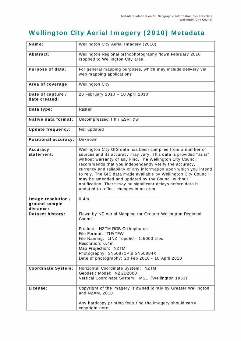
Wellington City Aerial Imagery (2010) Metadata Name:
Wellington City Aerial Imagery (2010)
Abstract:
Wellington Regional orthophotography flown February 2010 cropped to Wellington City area.
Purpose of data:
For general mapping purposes, which may include delivery via web mapping applications
Area of coverage:
Wellington City
Date of capture / date created:
20 February 2010 – 10 April 2010
Data type:
Raster
Native data format: Uncompressed Tiff / ESRI tfw
Update frequency:
Not updated
Positional accuracy:
Unknown
Accuracy statement:
Wellington City GIS data has been compiled from a number of sources and its accuracy may vary. This data is provided “as is” without warranty of any kind. The Wellington City Council recommends that you independently verify the accuracy, currency and reliability of any information upon which you intend to rely. The GIS data made available by Wellington City Council may be amended and updated by the Council without notification. There may be significant delays before data is updated to reflect changes in an area.
Image resolution / ground sample distance:
0.4m
Dataset history: Flown by NZ Aerial Mapping for Greater Wellington Regional Council. Product: NZTM RGB Orthophotos File Format: TIF/TFW File Naming: LINZ Topo50 - 1:5000 tiles Resolution: 0.4m Map Projection: NZTM Photography: SN50871P & SN50884X Date of photography: 20 Feb 2010 - 10 April 2010
Coordinate System: Horizontal Coordinate System: NZTM Geodetic Model: NZGD2000 Vertical Coordinate System: MSL (Wellington 1953)
License: Copyright of the imagery is owned jointly by Greater Wellington
and NZAM, 2010 Any hardcopy printing featuring the imagery should carry copyright note:

Metadata information for Geographic Information Systems Data Wellington City Council
“Regional Orthophotography Copyright : GWRC / NZAM 2010”
Additional Notes: For more information about this dataset contact Wellington Regional Council or New Zealand Aerial Mapping (NZAM)
Point of Contact:
GIS Operations Team Wellington City Council Email: [email protected] Phone: (04) 801 4228
Metadata information for Geographic Information Systems Data Wellington City Council
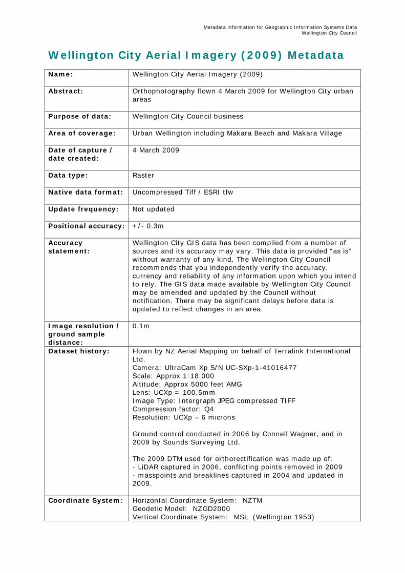
Wellington City Aerial Imagery (2009) Metadata Name:
Wellington City Aerial Imagery (2009)
Abstract:
Orthophotography flown 4 March 2009 for Wellington City urban areas
Purpose of data: Wellington City Council business
Area of coverage:
Urban Wellington including Makara Beach and Makara Village
Date of capture / date created:
4 March 2009
Data type:
Raster
Native data format: Uncompressed Tiff / ESRI tfw
Update frequency:
Not updated
Positional accuracy:
+/- 0.3m
Accuracy statement:
Wellington City GIS data has been compiled from a number of sources and its accuracy may vary. This data is provided “as is” without warranty of any kind. The Wellington City Council recommends that you independently verify the accuracy, currency and reliability of any information upon which you intend to rely. The GIS data made available by Wellington City Council may be amended and updated by the Council without notification. There may be significant delays before data is updated to reflect changes in an area.
Image resolution / ground sample distance:
0.1m
Dataset history: Flown by NZ Aerial Mapping on behalf of Terralink International Ltd. Camera: UltraCam Xp S/N UC-SXp-1-41016477 Scale: Approx 1:18,000 Altitude: Approx 5000 feet AMG Lens: UCXp = 100.5mm Image Type: Intergraph JPEG compressed TIFF Compression factor: Q4 Resolution: UCXp – 6 microns Ground control conducted in 2006 by Connell Wagner, and in 2009 by Sounds Surveying Ltd. The 2009 DTM used for orthorectification was made up of: - LiDAR captured in 2006, conflicting points removed in 2009 - masspoints and breaklines captured in 2004 and updated in 2009.
Coordinate System: Horizontal Coordinate System: NZTM Geodetic Model: NZGD2000 Vertical Coordinate System: MSL (Wellington 1953)

Metadata information for Geographic Information Systems Data Wellington City Council
License: Creative Commons Attribution 3.0 New Zealand
Additional Notes:
Point of Contact:
GIS Operations Team Wellington City Council Email: [email protected] Phone: (04) 801 4228
Metadata information for Geographic Information Systems Data Wellington City Council
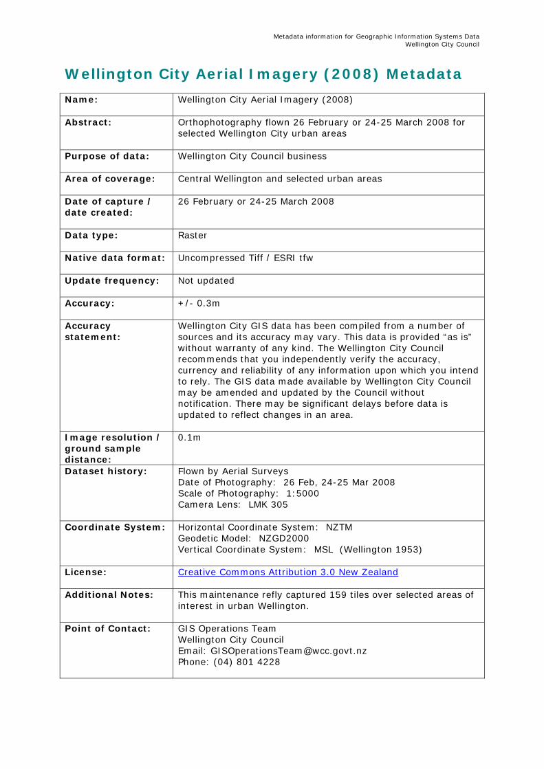
Wellington City Aerial Imagery (2008) Metadata Name:
Wellington City Aerial Imagery (2008)
Abstract:
Orthophotography flown 26 February or 24-25 March 2008 for selected Wellington City urban areas
Purpose of data: Wellington City Council business
Area of coverage:
Central Wellington and selected urban areas
Date of capture / date created:
26 February or 24-25 March 2008
Data type:
Raster
Native data format: Uncompressed Tiff / ESRI tfw
Update frequency:
Not updated
Accuracy:
+/- 0.3m
Accuracy statement:
Wellington City GIS data has been compiled from a number of sources and its accuracy may vary. This data is provided “as is” without warranty of any kind. The Wellington City Council recommends that you independently verify the accuracy, currency and reliability of any information upon which you intend to rely. The GIS data made available by Wellington City Council may be amended and updated by the Council without notification. There may be significant delays before data is updated to reflect changes in an area.
Image resolution / ground sample distance:
0.1m
Dataset history: Flown by Aerial Surveys Date of Photography: 26 Feb, 24-25 Mar 2008 Scale of Photography: 1:5000 Camera Lens: LMK 305
Coordinate System: Horizontal Coordinate System: NZTM Geodetic Model: NZGD2000 Vertical Coordinate System: MSL (Wellington 1953)
License: Creative Commons Attribution 3.0 New Zealand
Additional Notes: This maintenance refly captured 159 tiles over selected areas of
interest in urban Wellington.
Point of Contact:
GIS Operations Team Wellington City Council Email: [email protected] Phone: (04) 801 4228
Metadata information for Geographic Information Systems Data Wellington City Council
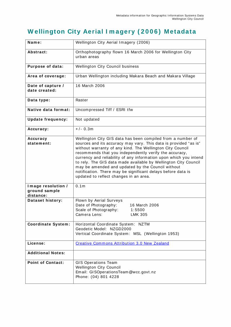
Wellington City Aerial Imagery (2006) Metadata Name:
Wellington City Aerial Imagery (2006)
Abstract:
Orthophotography flown 16 March 2006 for Wellington City urban areas
Purpose of data: Wellington City Council business
Area of coverage: Urban Wellington including Makara Beach and Makara Village
Date of capture / date created:
16 March 2006
Data type:
Raster
Native data format: Uncompressed Tiff / ESRI tfw
Update frequency:
Not updated
Accuracy:
+/- 0.3m
Accuracy statement:
Wellington City GIS data has been compiled from a number of sources and its accuracy may vary. This data is provided “as is” without warranty of any kind. The Wellington City Council recommends that you independently verify the accuracy, currency and reliability of any information upon which you intend to rely. The GIS data made available by Wellington City Council may be amended and updated by the Council without notification. There may be significant delays before data is updated to reflect changes in an area.
Image resolution / ground sample distance:
0.1m
Dataset history: Flown by Aerial Surveys Date of Photography: 16 March 2006 Scale of Photography: 1:5500 Camera Lens: LMK 305
Coordinate System: Horizontal Coordinate System: NZTM Geodetic Model: NZGD2000 Vertical Coordinate System: MSL (Wellington 1953)
License: Creative Commons Attribution 3.0 New Zealand
Additional Notes:
Point of Contact:
GIS Operations Team Wellington City Council Email: [email protected] Phone: (04) 801 4228
Metadata information for Geographic Information Systems Data Wellington City Council
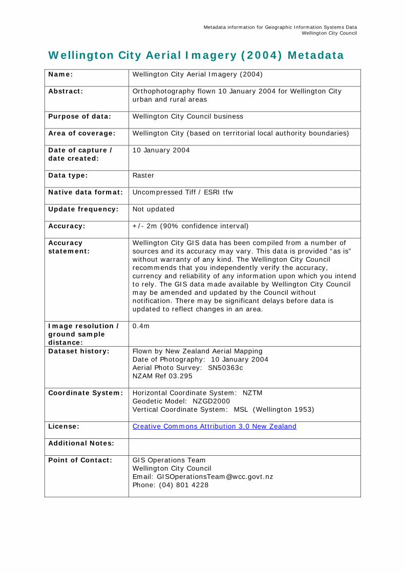
Wellington City Aerial Imagery (2004) Metadata Name:
Wellington City Aerial Imagery (2004)
Abstract:
Orthophotography flown 10 January 2004 for Wellington City urban and rural areas
Purpose of data: Wellington City Council business
Area of coverage:
Wellington City (based on territorial local authority boundaries)
Date of capture / date created:
10 January 2004
Data type:
Raster
Native data format: Uncompressed Tiff / ESRI tfw
Update frequency:
Not updated
Accuracy:
+/- 2m (90% confidence interval)
Accuracy statement:
Wellington City GIS data has been compiled from a number of sources and its accuracy may vary. This data is provided “as is” without warranty of any kind. The Wellington City Council recommends that you independently verify the accuracy, currency and reliability of any information upon which you intend to rely. The GIS data made available by Wellington City Council may be amended and updated by the Council without notification. There may be significant delays before data is updated to reflect changes in an area.
Image resolution / ground sample distance:
0.4m
Dataset history: Flown by New Zealand Aerial Mapping Date of Photography: 10 January 2004 Aerial Photo Survey: SN50363c NZAM Ref 03.295
Coordinate System: Horizontal Coordinate System: NZTM Geodetic Model: NZGD2000 Vertical Coordinate System: MSL (Wellington 1953)
License: Creative Commons Attribution 3.0 New Zealand
Additional Notes:
Point of Contact:
GIS Operations Team Wellington City Council Email: [email protected] Phone: (04) 801 4228
Metadata information for Geographic Information Systems Data Wellington City Council
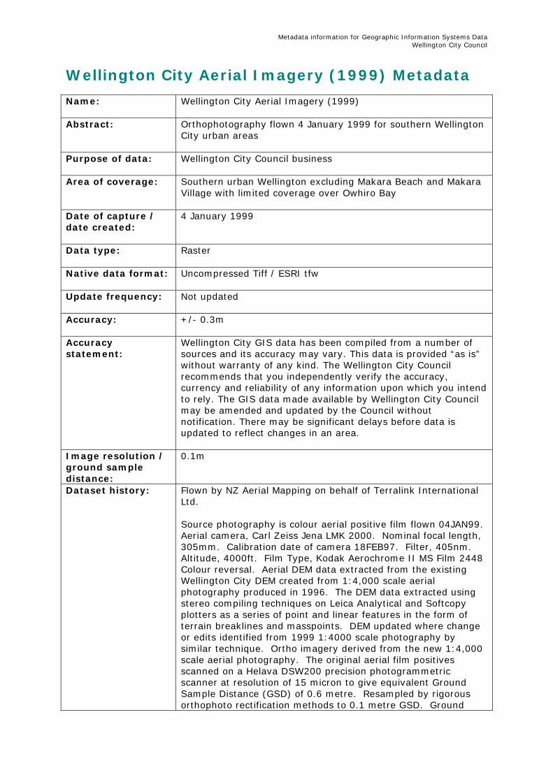
Wellington City Aerial Imagery (1999) Metadata Name:
Wellington City Aerial Imagery (1999)
Abstract:
Orthophotography flown 4 January 1999 for southern Wellington City urban areas
Purpose of data: Wellington City Council business
Area of coverage:
Southern urban Wellington excluding Makara Beach and Makara Village with limited coverage over Owhiro Bay
Date of capture / date created:
4 January 1999
Data type:
Raster
Native data format: Uncompressed Tiff / ESRI tfw
Update frequency:
Not updated
Accuracy:
+/- 0.3m
Accuracy statement:
Wellington City GIS data has been compiled from a number of sources and its accuracy may vary. This data is provided “as is” without warranty of any kind. The Wellington City Council recommends that you independently verify the accuracy, currency and reliability of any information upon which you intend to rely. The GIS data made available by Wellington City Council may be amended and updated by the Council without notification. There may be significant delays before data is updated to reflect changes in an area.
Image resolution / ground sample distance:
0.1m
Dataset history: Flown by NZ Aerial Mapping on behalf of Terralink International Ltd. Source photography is colour aerial positive film flown 04JAN99. Aerial camera, Carl Zeiss Jena LMK 2000. Nominal focal length, 305mm. Calibration date of camera 18FEB97. Filter, 405nm. Altitude, 4000ft. Film Type, Kodak Aerochrome II MS Film 2448 Colour reversal. Aerial DEM data extracted from the existing Wellington City DEM created from 1:4,000 scale aerial photography produced in 1996. The DEM data extracted using stereo compiling techniques on Leica Analytical and Softcopy plotters as a series of point and linear features in the form of terrain breaklines and masspoints. DEM updated where change or edits identified from 1999 1:4000 scale photography by similar technique. Ortho imagery derived from the new 1:4,000 scale aerial photography. The original aerial film positives scanned on a Helava DSW200 precision photogrammetric scanner at resolution of 15 micron to give equivalent Ground Sample Distance (GSD) of 0.6 metre. Resampled by rigorous orthophoto rectification methods to 0.1 metre GSD. Ground
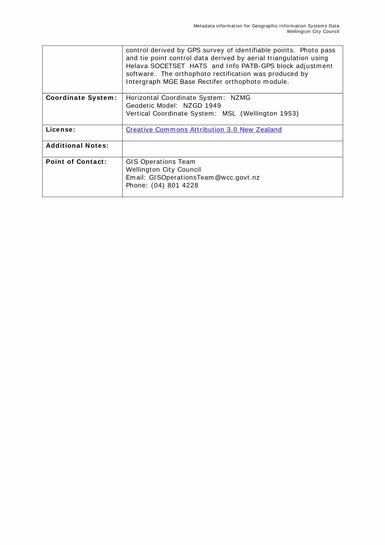
Metadata information for Geographic Information Systems Data Wellington City Council
control derived by GPS survey of identifiable points. Photo pass and tie point control data derived by aerial triangulation using Helava SOCETSET HATS and Info PATB-GPS block adjustment software. The orthophoto rectification was produced by Intergraph MGE Base Rectifer orthophoto module.
Coordinate System: Horizontal Coordinate System: NZMG Geodetic Model: NZGD 1949 Vertical Coordinate System: MSL (Wellington 1953)
License: Creative Commons Attribution 3.0 New Zealand
Additional Notes:
Point of Contact:
GIS Operations Team Wellington City Council Email: [email protected] Phone: (04) 801 4228
Metadata information for Geographic Information Systems Data Wellington City Council
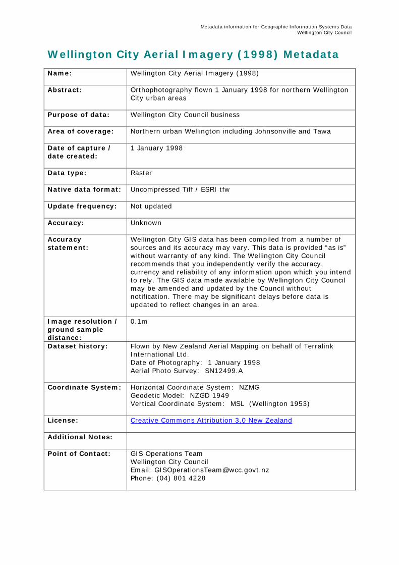
Wellington City Aerial Imagery (1998) Metadata Name:
Wellington City Aerial Imagery (1998)
Abstract:
Orthophotography flown 1 January 1998 for northern Wellington City urban areas
Purpose of data: Wellington City Council business
Area of coverage:
Northern urban Wellington including Johnsonville and Tawa
Date of capture / date created:
1 January 1998
Data type:
Raster
Native data format: Uncompressed Tiff / ESRI tfw
Update frequency:
Not updated
Accuracy:
Unknown
Accuracy statement:
Wellington City GIS data has been compiled from a number of sources and its accuracy may vary. This data is provided “as is” without warranty of any kind. The Wellington City Council recommends that you independently verify the accuracy, currency and reliability of any information upon which you intend to rely. The GIS data made available by Wellington City Council may be amended and updated by the Council without notification. There may be significant delays before data is updated to reflect changes in an area.
Image resolution / ground sample distance:
0.1m
Dataset history: Flown by New Zealand Aerial Mapping on behalf of Terralink International Ltd. Date of Photography: 1 January 1998 Aerial Photo Survey: SN12499.A
Coordinate System: Horizontal Coordinate System: NZMG Geodetic Model: NZGD 1949 Vertical Coordinate System: MSL (Wellington 1953)
License: Creative Commons Attribution 3.0 New Zealand
Additional Notes:
Point of Contact:
GIS Operations Team Wellington City Council Email: [email protected] Phone: (04) 801 4228
Metadata information for Geographic Information Systems Data Wellington City Council
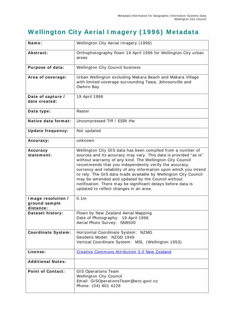
Wellington City Aerial Imagery (1996) Metadata Name:
Wellington City Aerial Imagery (1996)
Abstract:
Orthophotography flown 19 April 1996 for Wellington City urban areas
Purpose of data: Wellington City Council business
Area of coverage:
Urban Wellington excluding Makara Beach and Makara Village with limited coverage surrounding Tawa, Johnsonville and Owhiro Bay
Date of capture / date created:
19 April 1996
Data type:
Raster
Native data format: Uncompressed Tiff / ESRI tfw
Update frequency:
Not updated
Accuracy:
unknown
Accuracy statement:
Wellington City GIS data has been compiled from a number of sources and its accuracy may vary. This data is provided “as is” without warranty of any kind. The Wellington City Council recommends that you independently verify the accuracy, currency and reliability of any information upon which you intend to rely. The GIS data made available by Wellington City Council may be amended and updated by the Council without notification. There may be significant delays before data is updated to reflect changes in an area.
Image resolution / ground sample distance:
0.1m
Dataset history: Flown by New Zealand Aerial Mapping Date of Photography: 19 April 1996 Aerial Photo Survey: SN9500
Coordinate System: Horizontal Coordinate System: NZMG Geodetic Model: NZGD 1949 Vertical Coordinate System: MSL (Wellington 1953)
License: Creative Commons Attribution 3.0 New Zealand
Additional Notes:
Point of Contact:
GIS Operations Team Wellington City Council Email: [email protected] Phone: (04) 801 4228
Metadata information for Geographic Information Systems Data Wellington City Council
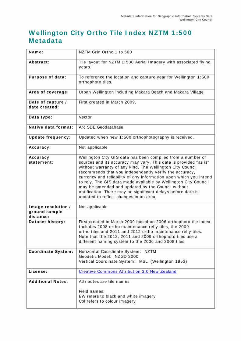
Wellington City Ortho Tile Index NZTM 1:500 Metadata Name:
NZTM Grid Ortho 1 to 500
Abstract:
Tile layout for NZTM 1:500 Aerial Imagery with associated flying years.
Purpose of data: To reference the location and capture year for Wellington 1:500 orthophoto tiles.
Area of coverage:
Urban Wellington including Makara Beach and Makara Village
Date of capture / date created:
First created in March 2009.
Data type:
Vector
Native data format: Arc SDE Geodatabase
Update frequency:
Updated when new 1:500 orthophotography is received.
Accuracy:
Not applicable
Accuracy statement:
Wellington City GIS data has been compiled from a number of sources and its accuracy may vary. This data is provided “as is” without warranty of any kind. The Wellington City Council recommends that you independently verify the accuracy, currency and reliability of any information upon which you intend to rely. The GIS data made available by Wellington City Council may be amended and updated by the Council without notification. There may be significant delays before data is updated to reflect changes in an area.
Image resolution / ground sample distance:
Not applicable
Dataset history: First created in March 2009 based on 2006 orthophoto tile index. Includes 2008 ortho maintenance refly tiles, the 2009 ortho tiles and 2011 and 2012 ortho maintenance refly tiles. Note that the 2012, 2011 and 2009 orthophoto tiles use a different naming system to the 2006 and 2008 tiles.
Coordinate System: Horizontal Coordinate System: NZTM Geodetic Model: NZGD 2000 Vertical Coordinate System: MSL (Wellington 1953)
License: Creative Commons Attribution 3.0 New Zealand
Additional Notes: Attributes are tile names
Field names: BW refers to black and white imagery Col refers to colour imagery
Metadata information for Geographic Information Systems Data Wellington City Council
Capture dates: 2006 photography - 16 March 2006 2008 photography - 26 Feb, 24 March or 25 March 2008 - refer to PhDate08 field 2009 photography - 04 March 2009 2011 photography - 30 December 2010 or 9 January 2011 – refer to PhDate11 field 2012 photography - 17 January 2012
Point of Contact:
GIS Operations Team Wellington City Council Email: [email protected] Phone: (04) 801 4228
Metadata information for Geographic Information Systems Data Wellington City Council
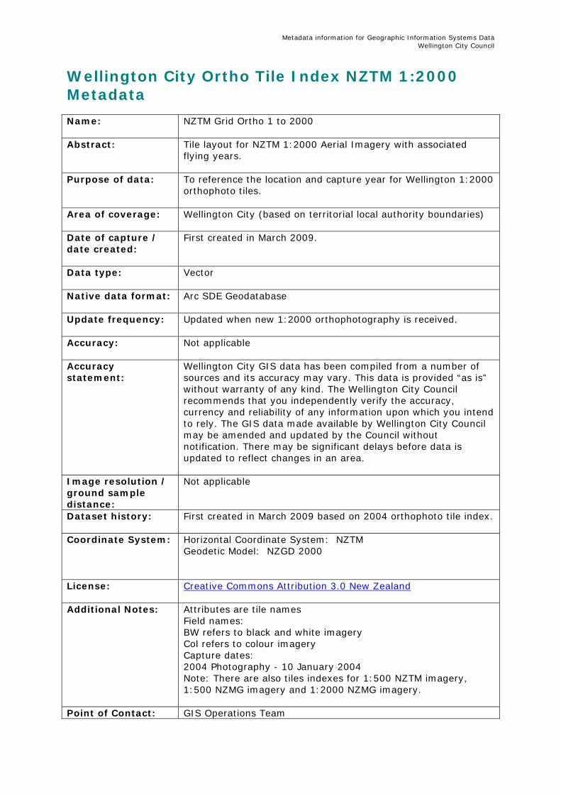
Wellington City Ortho Tile Index NZTM 1:2000 Metadata Name:
NZTM Grid Ortho 1 to 2000
Abstract:
Tile layout for NZTM 1:2000 Aerial Imagery with associated flying years.
Purpose of data: To reference the location and capture year for Wellington 1:2000 orthophoto tiles.
Area of coverage:
Wellington City (based on territorial local authority boundaries)
Date of capture / date created:
First created in March 2009.
Data type:
Vector
Native data format: Arc SDE Geodatabase
Update frequency:
Updated when new 1:2000 orthophotography is received.
Accuracy:
Not applicable
Accuracy statement:
Wellington City GIS data has been compiled from a number of sources and its accuracy may vary. This data is provided “as is” without warranty of any kind. The Wellington City Council recommends that you independently verify the accuracy, currency and reliability of any information upon which you intend to rely. The GIS data made available by Wellington City Council may be amended and updated by the Council without notification. There may be significant delays before data is updated to reflect changes in an area.
Image resolution / ground sample distance:
Not applicable
Dataset history: First created in March 2009 based on 2004 orthophoto tile index.
Coordinate System: Horizontal Coordinate System: NZTM Geodetic Model: NZGD 2000
License: Creative Commons Attribution 3.0 New Zealand
Additional Notes: Attributes are tile names Field names: BW refers to black and white imagery Col refers to colour imagery Capture dates: 2004 Photography - 10 January 2004 Note: There are also tiles indexes for 1:500 NZTM imagery, 1:500 NZMG imagery and 1:2000 NZMG imagery.
Point of Contact: GIS Operations Team

Metadata information for Geographic Information Systems Data Wellington City Council
Wellington City Council Email: [email protected] Phone: (04) 801 4228
Metadata information for Geographic Information Systems Data Wellington City Council
Wellington City 1m Contours (2012) Metadata Name:
Wellington City 1m Contours (2012)
Abstract:
1m Contours covering Central Wellington, Mt Cook, Newtown and selected parts of Crofton Downs, Newlands, Johnsonville, Woodridge, Tawa, Kilbirnie and Owhiro Bay. The contours were created from 2012 aerial photography. The DTM was created from 2006 LiDAR, 2009, 2011 and 2012 photogrammetry masspoints and breaklines. Contours generated from LiDAR and photogrametry should not be used for detailed engineering design.
Purpose of data: Wellington City Council business
Area of coverage:
Central Wellington, Mt Cook, Newtown and selected parts of Crofton Downs, Newlands, Johnsonville, Woodridge, Tawa, Kilbirnie and Owhiro Bay .
Date of capture / date created:
2012
Data type:
Vector
Native data format: Arc SDE Geodatabase
Update frequency:
Not updated
Accuracy:
+/- 0.5m in most areas (vertical). In some areas particularly in dense vegetation where no LiDAR data is available, the DTM is estimated and therefore less accurate.
Accuracy statement:
Wellington City GIS data has been compiled from a number of sources and its accuracy may vary. This data is provided “as is” without warranty of any kind. The Wellington City Council recommends that you independently verify the accuracy, currency and reliability of any information upon which you intend to rely. The GIS data made available by Wellington City Council may be amended and updated by the Council without notification. There may be significant delays before data is updated to reflect changes in an area.
Image resolution / ground sample distance:
Not applicable
Dataset history: LiDAR captured by AAMHatch March 2006. Points were removed where significant changes in the terrain were detected as part of the photogrammetry process in 2009 , 2011 and 2012. Mass points and breaklines captured by Terralink from 2009, 2011 and 2012 aerial photography.
Coordinate System: Horizontal Coordinate System: NZTM Geodetic Model: NZGD2000 Vertical Coordinate System: MSL Wellington 1953
License: Creative Commons Attribution 3.0 New Zealand

Metadata information for Geographic Information Systems Data Wellington City Council
Additional Notes: Contours generated from LiDAR and photogrammetry should not
be used for detailed engineering design.
Point of Contact:
GIS Operations Team Wellington City Council Email: [email protected] Phone: (04) 801 4228
Metadata information for Geographic Information Systems Data Wellington City Council
Wellington City 1m Contours (2011) Metadata Name:
Wellington City 1m Contours (2011)
Abstract:
1m Contours created from 2011 aerial photography. The DTM was created from 2006 LiDAR, 2009 and 2011 photogrametry masspoints and breaklines. Contours generated from LiDAR and photogrametry should not be used for detailed engineering design.
Purpose of data: Wellington City Council business
Area of coverage:
Central Wellington, Wellington Airport, Churton Park, Grenada North, Woodridge and other selected tiles.
Date of capture / date created:
2011
Data type:
Vector
Native data format: Arc SDE Geodatabase
Update frequency:
Not updated
Accuracy:
+/- 0.5m in most areas (vertical). In some areas particularly in dense vegetation where no LiDAR data is available, the DTM is estimated and therefore less accurate.
Accuracy statement:
Wellington City GIS data has been compiled from a number of sources and its accuracy may vary. This data is provided “as is” without warranty of any kind. The Wellington City Council recommends that you independently verify the accuracy, currency and reliability of any information upon which you intend to rely. The GIS data made available by Wellington City Council may be amended and updated by the Council without notification. There may be significant delays before data is updated to reflect changes in an area.
Image resolution / ground sample distance:
Not applicable
Dataset history: LiDAR captured by AAMHatch March 2006. Points were removed where significant changes in the terrain were detected as part of the photogrammetry process in 2009 and 2011. Mass points and breaklines captured by Terralink from 2009 & 2011 aerial photography.
Coordinate System: Horizontal Coordinate System: NZTM Geodetic Model: NZGD2000 Vertical Coordinate System: MSL Wellington 1953
License: Creative Commons Attribution 3.0 New Zealand
Additional Notes: Contours generated from LiDAR and photogrammetry should not
be used for detailed engineering design.

Metadata information for Geographic Information Systems Data Wellington City Council
Point of Contact:
GIS Operations Team Wellington City Council Email: [email protected] Phone: (04) 801 4228
Metadata information for Geographic Information Systems Data Wellington City Council
Wellington City 1m Contours Metadata Name:
Wellington City 1m Contours
Abstract:
1m contours for urban Wellington created from 2009 aerial photography.
Purpose of data: Wellington City Council business
Area of coverage:
Urban Wellington including Makara Beach and Makara Village
Date of capture / date created:
Based on a DTM created from 2006 LiDAR and 2009 photogrammetry masspoints and breaklines
Data type:
Vector
Native data format: Arc SDE Geodatabase
Update frequency:
Not updated
Accuracy:
+/- 0.5m in most areas (vertical). In some areas particularly in dense vegetation where no LiDAR data is available, the DTM is estimated and therefore less accurate.
Accuracy statement:
Wellington City GIS data has been compiled from a number of sources and its accuracy may vary. This data is provided “as is” without warranty of any kind. The Wellington City Council recommends that you independently verify the accuracy, currency and reliability of any information upon which you intend to rely. The GIS data made available by Wellington City Council may be amended and updated by the Council without notification. There may be significant delays before data is updated to reflect changes in an area.
Image resolution / ground sample distance:
Not applicable
Dataset history: LiDAR captured by AAMHatch March 2006. Points were removed where significant changes in the terrain were detected as part of the photogrammetry process in 2009. Mass points and breaklines were captured by Terralink from 2009 aerial photography. WCC generalised the contours by up to 0.2m in order to reduce the number of vertices in the dataset.
Coordinate System: Horizontal Coordinate System: NZTM Geodetic Model: NZGD2000 Vertical Coordinate System: MSL Wellington 1953
License: Creative Commons Attribution 3.0 New Zealand
Additional Notes: Contours generated from LiDAR and photogrammetry should not
be used for detailed engineering design.
Point of Contact: GIS Operations Team

Metadata information for Geographic Information Systems Data Wellington City Council
Wellington City Council Email: [email protected] Phone: (04) 801 4228

Metadata information for Geographic Information Systems Data Wellington City Council
Wellington City 5m Contours Metadata Name:
Wellington City 5m Contours
Abstract:
5m contours for rural and urban Wellington created from 2004 aerial photography
Purpose of data: Wellington City Council business
Area of coverage:
Wellington City (based on territorial local authority boundaries)
Date of capture / date created:
Derived from data captured as part of the Wellington City Rural Aerial Photography project 2004
Data type:
Vector
Native data format: Arc SDE Geodatabase
Update frequency:
Not updated
Accuracy:
+/- 5m estimated vertical accuracy
Accuracy statement:
Wellington City GIS data has been compiled from a number of sources and its accuracy may vary. This data is provided “as is” without warranty of any kind. The Wellington City Council recommends that you independently verify the accuracy, currency and reliability of any information upon which you intend to rely. The GIS data made available by Wellington City Council may be amended and updated by the Council without notification. There may be significant delays before data is updated to reflect changes in an area.
Image resolution / ground sample distance:
Not applicable
Dataset history: Rural Aerial Photography refly project carried by NZ Aerial Mapping Ltd Data supplied in ESRI shapefile (Polylines), June 2004 Feature Attributes: ELEVATION (DTM Point Elevation – metres) Coordinate System: NZMG/MSL:WGTN 1953 Products produced using; Aerial Photo Survey: SN50363c Date of Photography: 10 January 2004 NZAM Ref 03.295 Reprojected into NZTM coordinate system in 2009
Coordinate System: Horizontal Coordinate System: NZTM Geodetic Model: NZGD2000 Vertical Coordinate system: MSL Wellington 1953
License: Creative Commons Attribution 3.0 New Zealand
Additional Notes: Contours generated from photogrammetry should not be used
for detailed engineering design.

Metadata information for Geographic Information Systems Data Wellington City Council
Point of Contact:
GIS Operations Team Wellington City Council Email: [email protected] Phone: (04) 801 4228
Metadata information for Geographic Information Systems Data Wellington City Council
Wellington City Building Footprints Metadata Name:
Wellington City Building Footprints
Abstract:
Polygons representing building rooftop outlines. Each building has an associated elevation above MSL (Wellington 1953). The rooftop elevation does not include above roof structures such as aerials or chimneys.
Purpose of data: Wellington City Council business
Area of coverage: Urban Wellington including Makara Beach and Makara Village
Date of capture / date created:
Captured in 1996 and updated in 1998, 1999, 2002, 2006, 2009, 2011 and 2012 in conjunction with aerial photography refly projects.
Data type:
Vector
Native data format: Arc SDE Geodatabase
Update frequency:
Updated as part of aerial photography refly projects, approximately every three years.
Accuracy statement:
Wellington City GIS data has been compiled from a number of sources and its accuracy may vary. This data is provided “as is” without warranty of any kind. The Wellington City Council recommends that you independently verify the accuracy, currency and reliability of any information upon which you intend to rely. The GIS data made available by Wellington City Council may be amended and updated by the Council without notification. There may be significant delays before data is updated to reflect changes in an area. Most building roof elevations are estimated from stereo photogrammetry therefore should only be used as a guide.
Accuracy:
Horizontal: +/- 0.15 - 0.3m
Image resolution / ground sample distance:
Not applicable
Dataset history: The Wellington City Council has acquired Building outline data since 1987. The data was originally loaded on the old City Mapping system then completely recaptured in 1996 for the Council’s new GIS system. The data has been captured from aerial photographs (stereopairs) Since 1996 the data has been updated in 1998, 1999, 2002 and 2009, 2011 and 2012 by Terralink, and updated in 2006 by Aerial Surveys Refer to CD164 (aka AI103) for historic data City Mapping, 1996, 1998 and 1999 City Mapping:
Metadata information for Geographic Information Systems Data Wellington City Council
Positional accuracy 0.15m. Data was captured between 1987 and 1996. The last update was the Miramar Area from the 1996 re-fly. Some Karori buildings are missing. Buildings were represented as polylines. 1996: - Data derived from aerial photographs captured between February and March 1996 - Positional accuracy 0.15m for the Miramar Peninsula and 0.30m for the rest. - This data was captured independently from City Mapping data - Only the visible part of buildings partially hidden by trees has been captured. - minimum building area 10m² 1998: - Positional Accuracy 0.15m - Data derived from aerial photographs captured in January 1998 - Only new buildings have been captured however some are missing. - Data covers northern suburbs (north of line Y = 5 994 625 NZMG) 1999: - Positional Accuracy 0.15m - Data derived from aerial photographs captured on 4 January 1999 - Includes all buildings, kerblines and fence/wall data for southern suburbs.(south of line Y = 5 994 625 NZMG) - Data is an update of City Mapping data (see above). - For CBD area, elevation of building’s heighest point is included as an attribute. – The elevation is above mean sea level. - The building data has been captured in a different way than 1996 vector data e.g.: - multi-unit shown as single polygons instead of separate polygons - decks generally not included - there are many more smaller structures - invisible parts of buildings have been estimated (?) - It is not possible to do a straight comparison between 96 and 99 data e.g. increase in building density or change in number of buildings. Check to identify buildings with “holes”, removed “hole” polygons (checked on orthophoto) In some cases no hole could be identified and “hole” polygon was merged with main polygon Southern Areas, check to identify missing buildings i.e. buildings that are present in 96 data but not in 99 data. All missing buildings were checked. In most cases buildings no longer exist but in some cases buildings were missing and 1996 buildings added. Northern Areas, merged 1996 and 1998 buildings. Checked were 1998 overlaps 1996 building. Were overlap occurred deleted 1996 building. Visual check of overlay of buildings with 1998 orthophoto to identify 1996 buildings that no longer exist. It was noted that a number of new buildings were missing. In many cases buildings such as water reservoirs are also
Metadata information for Geographic Information Systems Data Wellington City Council
missing. Checked boundary line between 1998 and 1999 data to ensure seamless joins and avoid overlapping buildings. Attributes: Feat_code (string 15), Accurac_xy (string 15), Source (string 15), Area (Number 8,0), Elevation (number 8,0) feat_code = building (for all records) 2002: - Positional Accuracy 0.30m - Data derived from aerial photographs captured on 18 February 2006 -Data derived from aerial photographs captured on 16 March 2008 -Partial update. Data derived from aerial photographs captured on 16 March 2009 -Data derived from aerial photographs captured on 4 March 2011 -Partial update. Data derived from aerial photographs captured between 30 December and 9 January 2011 2012 -Partial update. Data derived from aerial photographs captured on 17 January 2012
Coordinate System: Horizontal Coordinate System: NZTM Geodetic Model: NZGD2000 Vertical Coordinate System: MSL (Wellington 1953)
License: Creative Commons Attribution 3.0 New Zealand
Additional Notes:
Point of Contact:
GIS Operations Team Wellington City Council Email: [email protected] Phone: (04) 801 4228
Metadata information for Geographic Information Systems Data Wellington City Council
Wellington City Kerbs Metadata Name:
Wellington City Kerbs
Abstract:
Lines representing kerb lines, edge of seal and traffic islands.
Purpose of data: Wellington City Council business
Area of coverage: Urban Wellington including Makara Beach and Makara Village
Date of capture / date created:
Captured in 1996 and updated in 1998, 1999, 2002, 2006, 2009, 2011 and 2012 in conjunction with aerial photography refly projects
Data type:
Vector
Native data format: Arc SDE Geodatabase
Update frequency:
Updated as part of aerial photography refly projects, approximately every three years.
Accuracy statement:
Wellington City GIS data has been compiled from a number of sources and its accuracy may vary. This data is provided “as is” without warranty of any kind. The Wellington City Council recommends that you independently verify the accuracy, currency and reliability of any information upon which you intend to rely. The GIS data made available by Wellington City Council may be amended and updated by the Council without notification. There may be significant delays before data is updated to reflect changes in an area.
Accuracy:
Horizontal: +/- 0.15 - 0.3m
Image resolution / ground sample distance:
Not applicable
Dataset history: The Wellington City Council has acquired Kerb Line data since 1987. The data was originally loaded on the old City Mapping system then completely recaptured in 1996 for the Council's new GIS system. The data has been captured from aerial photographs (stereopairs) Since 1996 the data has been updated in 1998, 1999, 2002, 2004, 2009 and 2011 by Terralink, and in 2006 by Aerial Surveys (formerly GeoSmart). Refer to CD164 (aka AI103) for historic data City Mapping, 1996, 1998 and 1999 City Mapping: Positional accuracy 0.15m. Data was captured between 1987 and 1996. The last update was the Miramar Area from the 1996 refly. Some Karori buildings are missing. Buildings were represented as polylines. 1996:
Metadata information for Geographic Information Systems Data Wellington City Council
- Data derived from aerial photographs captured between February and March 1996 - Positional accuracy 0.3m for the Miramar Peninsula and 0.30m for the rest. - This data was captured independently from City Mapping data 1998: - Positional Accuracy 0.3m - Data derived from aerial photographs captured in January 1998 - Data covers northern suburbs (north of line Y = 5 994 625 NZMG) 1999: - Positional Accuracy 0.3m - Data derived from aerial photographs captured on 4 January 1999 - Includes all kerblines for southern suburbs.(south of line Y = 5 994 625 NZMG) - Data is an update of City Mapping data (see above). - Merged 1998 and 1999 data. Checked data to ensure seamless joins to avoid duplications. Imported 1996 kerblines where 98 or 99 are missing. Snapped lines to 98/99 lines. -Adjusted 1999 bridges to ensure bridge display consistency i.e. bridge deck masks kerblines of road passing underneath. - Added Botanic Gardens pathways from Wynne Paterson McLeod 1995 Survey - Kerbline position have been approximated for Ngauranga Gorge - Newlands Rd Bridge over Highway. feat_code = rail, eos, kerb, path, track, bridge 2002: - Positional Accuracy 0.30m - Data derived from aerial photographs captured on 18 February 2002 2004 - Partial update 2006 - Positional Accuracy 0.30m - Data derived from aerial photographs captured on 16 March 2006 - feat_code = eos (edge of seal), kerb, ti (traffic island) - feat_code = rail, track, path, weighbridge, bridge were removed and added to a new dataset: linear features 2008 - Partial update 2009 - Positional Accuracy 0.30m - Data derived from aerial photographs captured on 4 March 2011 -Partial update. Data derived from aerial photographs captured between 30 December and 9 January 2011
Metadata information for Geographic Information Systems Data Wellington City Council
2012 -Partial update. Data derived from aerial photographs captured on 17 January 2012
Coordinate System: Horizontal Coordinate System: NZTM Geodetic Model: NZGD2000
License: Creative Commons Attribution 3.0 New Zealand
Additional Notes:
Point of Contact:
GIS Operations Team Wellington City Council Email: [email protected] Phone: (04) 801 4228
Metadata information for Geographic Information Systems Data Wellington City Council
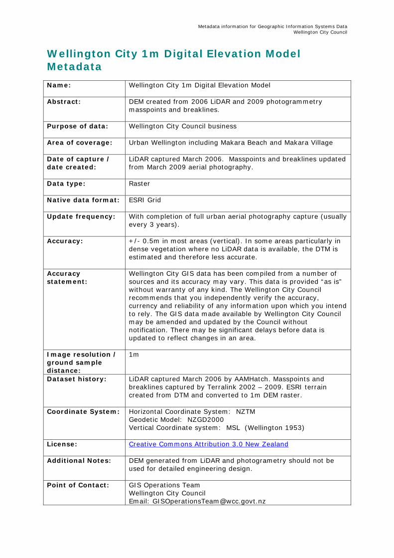
Wellington City 1m Digital Elevation Model Metadata Name:
Wellington City 1m Digital Elevation Model
Abstract:
DEM created from 2006 LiDAR and 2009 photogrammetry masspoints and breaklines.
Purpose of data: Wellington City Council business
Area of coverage:
Urban Wellington including Makara Beach and Makara Village
Date of capture / date created:
LiDAR captured March 2006. Masspoints and breaklines updated from March 2009 aerial photography.
Data type:
Raster
Native data format: ESRI Grid
Update frequency:
With completion of full urban aerial photography capture (usually every 3 years).
Accuracy:
+/- 0.5m in most areas (vertical). In some areas particularly in dense vegetation where no LiDAR data is available, the DTM is estimated and therefore less accurate.
Accuracy statement:
Wellington City GIS data has been compiled from a number of sources and its accuracy may vary. This data is provided “as is” without warranty of any kind. The Wellington City Council recommends that you independently verify the accuracy, currency and reliability of any information upon which you intend to rely. The GIS data made available by Wellington City Council may be amended and updated by the Council without notification. There may be significant delays before data is updated to reflect changes in an area.
Image resolution / ground sample distance:
1m
Dataset history: LiDAR captured March 2006 by AAMHatch. Masspoints and breaklines captured by Terralink 2002 – 2009. ESRI terrain created from DTM and converted to 1m DEM raster.
Coordinate System: Horizontal Coordinate System: NZTM Geodetic Model: NZGD2000 Vertical Coordinate system: MSL (Wellington 1953)
License: Creative Commons Attribution 3.0 New Zealand
Additional Notes: DEM generated from LiDAR and photogrametry should not be
used for detailed engineering design.
Point of Contact:
GIS Operations Team Wellington City Council Email: [email protected]

Metadata information for Geographic Information Systems Data Wellington City Council
Phone: (04) 801 4228
Metadata information for Geographic Information Systems Data Wellington City Council
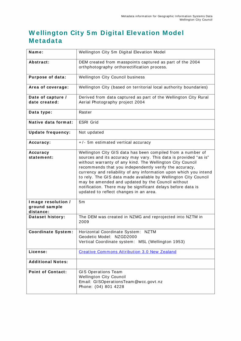
Wellington City 5m Digital Elevation Model Metadata Name:
Wellington City 5m Digital Elevation Model
Abstract:
DEM created from masspoints captured as part of the 2004 orthphotography orthorectification process.
Purpose of data: Wellington City Council business
Area of coverage:
Wellington City (based on territorial local authority boundaries)
Date of capture / date created:
Derived from data captured as part of the Wellington City Rural Aerial Photography project 2004
Data type:
Raster
Native data format: ESRI Grid
Update frequency:
Not updated
Accuracy:
+/- 5m estimated vertical accuracy
Accuracy statement:
Wellington City GIS data has been compiled from a number of sources and its accuracy may vary. This data is provided “as is” without warranty of any kind. The Wellington City Council recommends that you independently verify the accuracy, currency and reliability of any information upon which you intend to rely. The GIS data made available by Wellington City Council may be amended and updated by the Council without notification. There may be significant delays before data is updated to reflect changes in an area.
Image resolution / ground sample distance:
5m
Dataset history: The DEM was created in NZMG and reprojected into NZTM in 2009
Coordinate System: Horizontal Coordinate System: NZTM Geodetic Model: NZGD2000 Vertical Coordinate system: MSL (Wellington 1953)
License: Creative Commons Attribution 3.0 New Zealand
Additional Notes:
Point of Contact:
GIS Operations Team Wellington City Council Email: [email protected] Phone: (04) 801 4228
Metadata information for Geographic Information Systems Data Wellington City Council
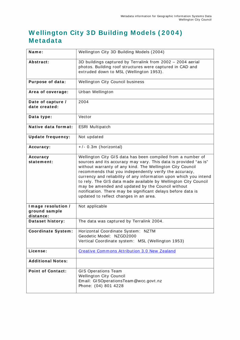
Wellington City 3D Building Models (2004) Metadata Name:
Wellington City 3D Building Models (2004)
Abstract:
3D buildings captured by Terralink from 2002 – 2004 aerial photos. Building roof structures were captured in CAD and extruded down to MSL (Wellington 1953).
Purpose of data: Wellington City Council business
Area of coverage:
Urban Wellington
Date of capture / date created:
2004
Data type:
Vector
Native data format: ESRI Multipatch
Update frequency:
Not updated
Accuracy:
+/- 0.3m (horizontal)
Accuracy statement:
Wellington City GIS data has been compiled from a number of sources and its accuracy may vary. This data is provided “as is” without warranty of any kind. The Wellington City Council recommends that you independently verify the accuracy, currency and reliability of any information upon which you intend to rely. The GIS data made available by Wellington City Council may be amended and updated by the Council without notification. There may be significant delays before data is updated to reflect changes in an area.
Image resolution / ground sample distance:
Not applicable
Dataset history: The data was captured by Terralink 2004.
Coordinate System: Horizontal Coordinate System: NZTM Geodetic Model: NZGD2000 Vertical Coordinate system: MSL (Wellington 1953)
License: Creative Commons Attribution 3.0 New Zealand
Additional Notes:
Point of Contact:
GIS Operations Team Wellington City Council Email: [email protected] Phone: (04) 801 4228
Metadata information for Geographic Information Systems Data Wellington City Council
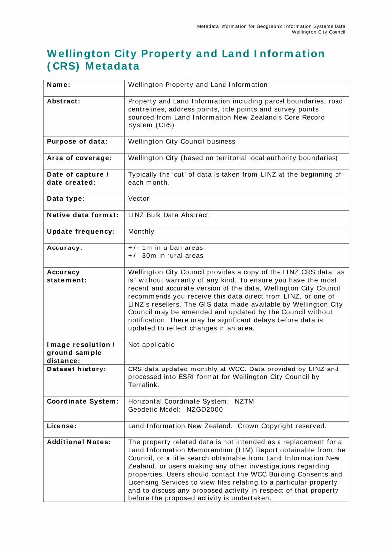
Wellington City Property and Land Information (CRS) Metadata Name:
Wellington Property and Land Information
Abstract:
Property and Land Information including parcel boundaries, road centrelines, address points, title points and survey points sourced from Land Information New Zealand’s Core Record System (CRS)
Purpose of data: Wellington City Council business
Area of coverage:
Wellington City (based on territorial local authority boundaries)
Date of capture / date created:
Typically the ‘cut’ of data is taken from LINZ at the beginning of each month.
Data type:
Vector
Native data format: LINZ Bulk Data Abstract
Update frequency:
Monthly
Accuracy:
+/- 1m in urban areas +/- 30m in rural areas
Accuracy statement:
Wellington City Council provides a copy of the LINZ CRS data “as is” without warranty of any kind. To ensure you have the most recent and accurate version of the data, Wellington City Council recommends you receive this data direct from LINZ, or one of LINZ’s resellers. The GIS data made available by Wellington City Council may be amended and updated by the Council without notification. There may be significant delays before data is updated to reflect changes in an area.
Image resolution / ground sample distance:
Not applicable
Dataset history: CRS data updated monthly at WCC. Data provided by LINZ and processed into ESRI format for Wellington City Council by Terralink.
Coordinate System: Horizontal Coordinate System: NZTM Geodetic Model: NZGD2000
License: Land Information New Zealand. Crown Copyright reserved.
Additional Notes: The property related data is not intended as a replacement for a Land Information Memorandum (LIM) Report obtainable from the Council, or a title search obtainable from Land Information New Zealand, or users making any other investigations regarding properties. Users should contact the WCC Building Consents and Licensing Services to view files relating to a particular property and to discuss any proposed activity in respect of that property before the proposed activity is undertaken.

Metadata information for Geographic Information Systems Data Wellington City Council
Point of Contact:
GIS Operations Team Wellington City Council Email: [email protected] Phone: (04) 801 4228
Metadata information for Geographic Information Systems Data Wellington City Council
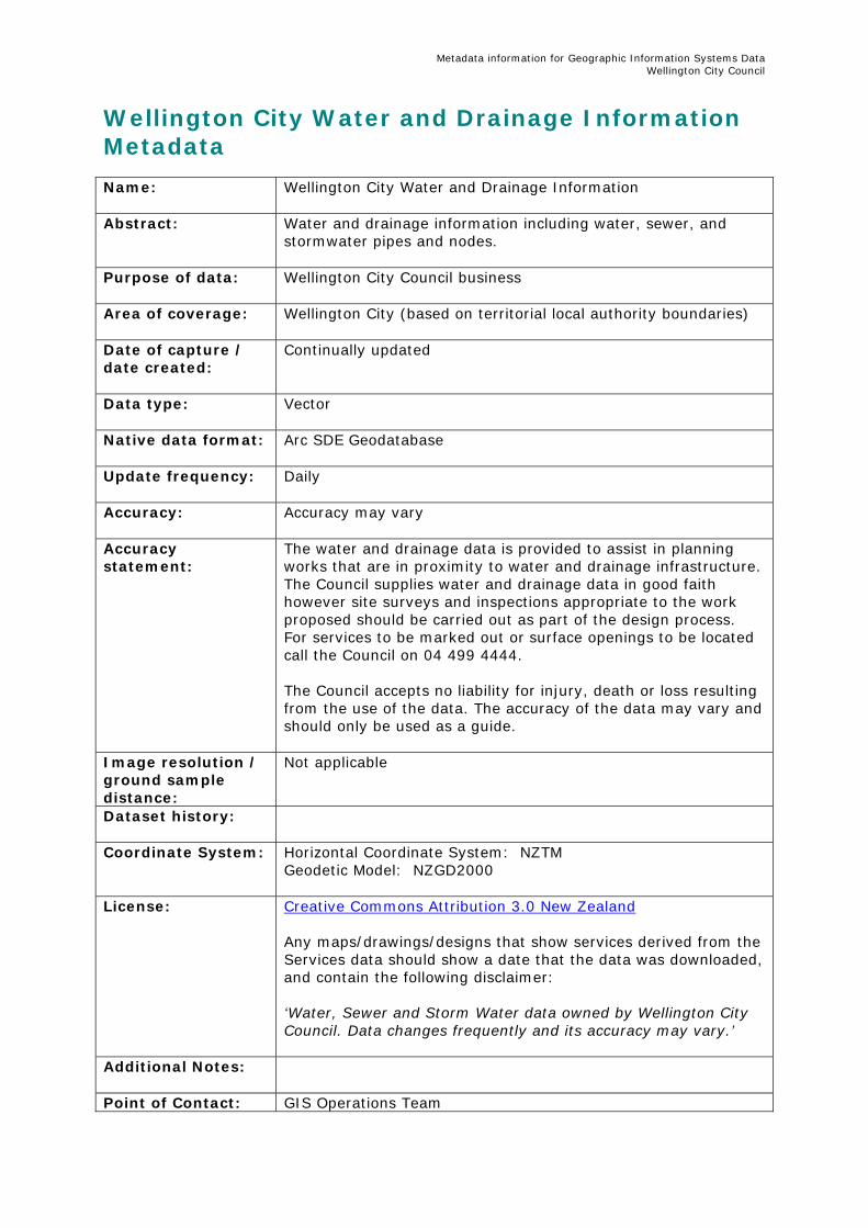
Wellington City Water and Drainage Information Metadata Name:
Wellington City Water and Drainage Information
Abstract:
Water and drainage information including water, sewer, and stormwater pipes and nodes.
Purpose of data: Wellington City Council business
Area of coverage:
Wellington City (based on territorial local authority boundaries)
Date of capture / date created:
Continually updated
Data type:
Vector
Native data format: Arc SDE Geodatabase
Update frequency:
Daily
Accuracy:
Accuracy may vary
Accuracy statement:
The water and drainage data is provided to assist in planning works that are in proximity to water and drainage infrastructure. The Council supplies water and drainage data in good faith however site surveys and inspections appropriate to the work proposed should be carried out as part of the design process. For services to be marked out or surface openings to be located call the Council on 04 499 4444. The Council accepts no liability for injury, death or loss resulting from the use of the data. The accuracy of the data may vary and should only be used as a guide.
Image resolution / ground sample distance:
Not applicable
Dataset history:
Coordinate System: Horizontal Coordinate System: NZTM Geodetic Model: NZGD2000
License: Creative Commons Attribution 3.0 New Zealand Any maps/drawings/designs that show services derived from the Services data should show a date that the data was downloaded, and contain the following disclaimer: ‘Water, Sewer and Storm Water data owned by Wellington City Council. Data changes frequently and its accuracy may vary.’
Additional Notes:
Point of Contact: GIS Operations Team

Metadata information for Geographic Information Systems Data Wellington City Council
Wellington City Council Email: [email protected] Phone: (04) 801 4228
Metadata information for Geographic Information Systems Data Wellington City Council
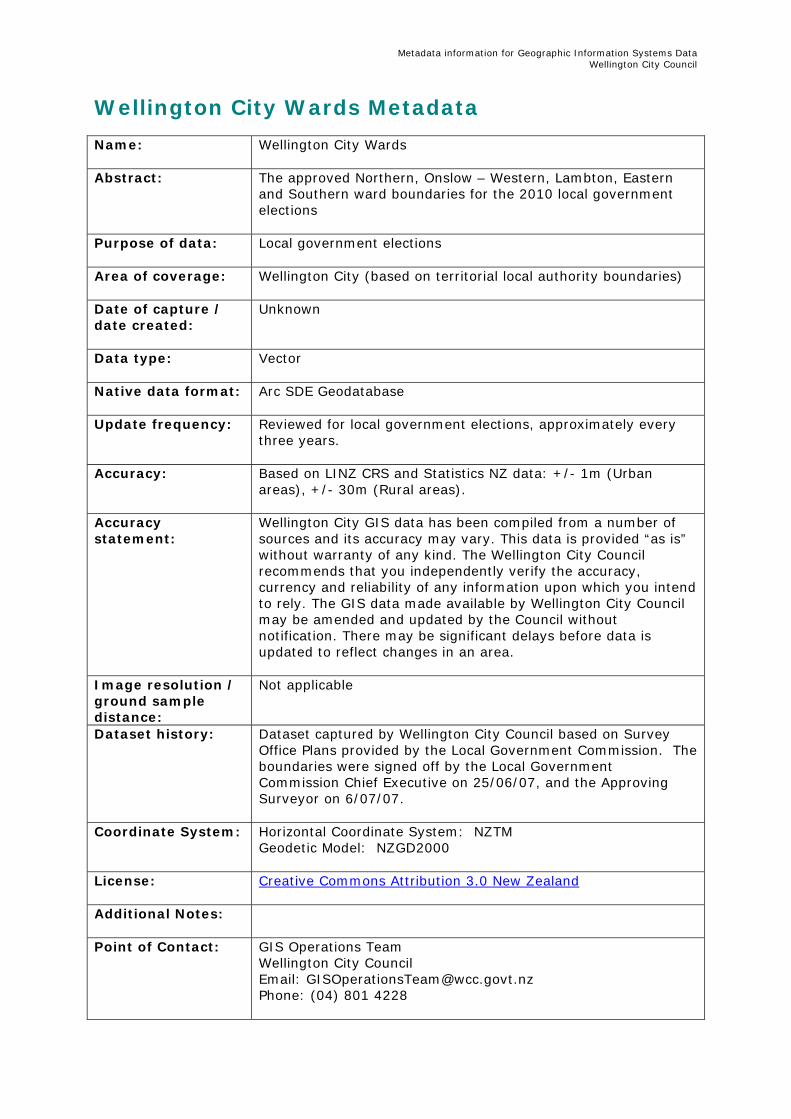
Wellington City Wards Metadata Name:
Wellington City Wards
Abstract:
The approved Northern, Onslow – Western, Lambton, Eastern and Southern ward boundaries for the 2010 local government elections
Purpose of data: Local government elections
Area of coverage:
Wellington City (based on territorial local authority boundaries)
Date of capture / date created:
Unknown
Data type:
Vector
Native data format: Arc SDE Geodatabase
Update frequency:
Reviewed for local government elections, approximately every three years.
Accuracy:
Based on LINZ CRS and Statistics NZ data: +/- 1m (Urban areas), +/- 30m (Rural areas).
Accuracy statement:
Wellington City GIS data has been compiled from a number of sources and its accuracy may vary. This data is provided “as is” without warranty of any kind. The Wellington City Council recommends that you independently verify the accuracy, currency and reliability of any information upon which you intend to rely. The GIS data made available by Wellington City Council may be amended and updated by the Council without notification. There may be significant delays before data is updated to reflect changes in an area.
Image resolution / ground sample distance:
Not applicable
Dataset history: Dataset captured by Wellington City Council based on Survey Office Plans provided by the Local Government Commission. The boundaries were signed off by the Local Government Commission Chief Executive on 25/06/07, and the Approving Surveyor on 6/07/07.
Coordinate System: Horizontal Coordinate System: NZTM Geodetic Model: NZGD2000
License: Creative Commons Attribution 3.0 New Zealand
Additional Notes:
Point of Contact:
GIS Operations Team Wellington City Council Email: [email protected] Phone: (04) 801 4228
Metadata information for Geographic Information Systems Data Wellington City Council
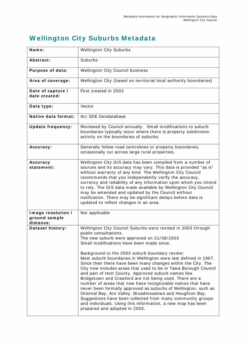
Wellington City Suburbs Metadata Name:
Wellington City Suburbs
Abstract:
Suburbs
Purpose of data: Wellington City Council business
Area of coverage:
Wellington City (based on territorial local authority boundaries)
Date of capture / date created:
First created in 2003
Data type:
Vector
Native data format: Arc SDE Geodatabase
Update frequency:
Reviewed by Council annually. Small modifications to suburb boundaries typically occur where there is property subdivision activity on the boundaries of suburbs.
Accuracy:
Generally follow road centrelines or property boundaries, occasionally cut across large rural properties.
Accuracy statement:
Wellington City GIS data has been compiled from a number of sources and its accuracy may vary. This data is provided “as is” without warranty of any kind. The Wellington City Council recommends that you independently verify the accuracy, currency and reliability of any information upon which you intend to rely. The GIS data made available by Wellington City Council may be amended and updated by the Council without notification. There may be significant delays before data is updated to reflect changes in an area.
Image resolution / ground sample distance:
Not applicable
Dataset history: Wellington City Council Suburbs were revised in 2003 through public consultations. The new suburb were approved on 21/08/2003 Small modifications have been made since. Background to the 2003 suburb boundary review: Most suburb boundaries in Wellington were last defined in 1967. Since then there have been many changes within the City. The City now includes areas that used to be in Tawa Borough Council and part of Hutt County. Approved suburb names like Bridgetown and Crawford are not being used. There are a number of areas that now have recognizable names that have never been formally approved as suburbs of Wellington, such as Oriental Bay, Aro Valley, Broadmeadows and Houghton Bay. Suggestions have been collected from many community groups and individuals. Using this information, a new map has been prepared and adopted in 2003.

Metadata information for Geographic Information Systems Data Wellington City Council
Coordinate System: Horizontal Coordinate System: NZTM Geodetic Model: NZGD2000
License: Creative Commons Attribution 3.0 New Zealand
Additional Notes:
Point of Contact:
GIS Operations Team Wellington City Council Email: [email protected] Phone: (04) 801 4228
Metadata information for Geographic Information Systems Data Wellington City Council
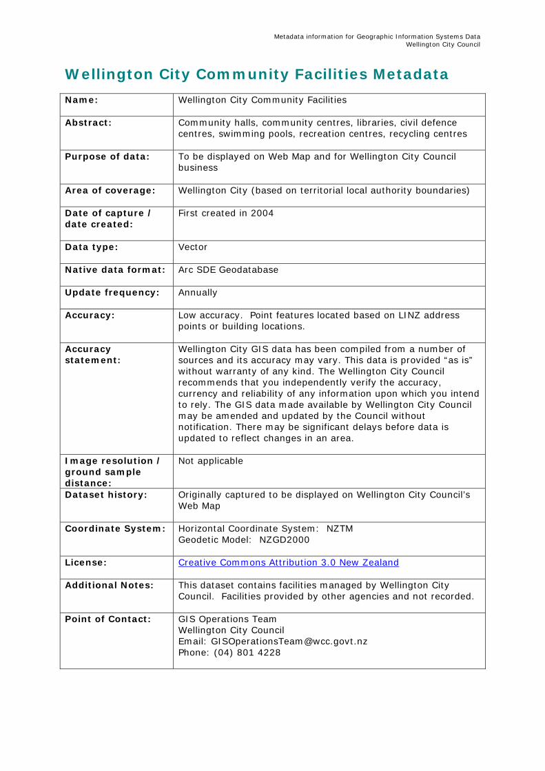
Wellington City Community Facilities Metadata Name:
Wellington City Community Facilities
Abstract:
Community halls, community centres, libraries, civil defence centres, swimming pools, recreation centres, recycling centres
Purpose of data: To be displayed on Web Map and for Wellington City Council business
Area of coverage:
Wellington City (based on territorial local authority boundaries)
Date of capture / date created:
First created in 2004
Data type:
Vector
Native data format: Arc SDE Geodatabase
Update frequency:
Annually
Accuracy:
Low accuracy. Point features located based on LINZ address points or building locations.
Accuracy statement:
Wellington City GIS data has been compiled from a number of sources and its accuracy may vary. This data is provided “as is” without warranty of any kind. The Wellington City Council recommends that you independently verify the accuracy, currency and reliability of any information upon which you intend to rely. The GIS data made available by Wellington City Council may be amended and updated by the Council without notification. There may be significant delays before data is updated to reflect changes in an area.
Image resolution / ground sample distance:
Not applicable
Dataset history: Originally captured to be displayed on Wellington City Council’s Web Map
Coordinate System: Horizontal Coordinate System: NZTM Geodetic Model: NZGD2000
License: Creative Commons Attribution 3.0 New Zealand
Additional Notes: This dataset contains facilities managed by Wellington City Council. Facilities provided by other agencies and not recorded.
Point of Contact:
GIS Operations Team Wellington City Council Email: [email protected] Phone: (04) 801 4228
Metadata information for Geographic Information Systems Data Wellington City Council
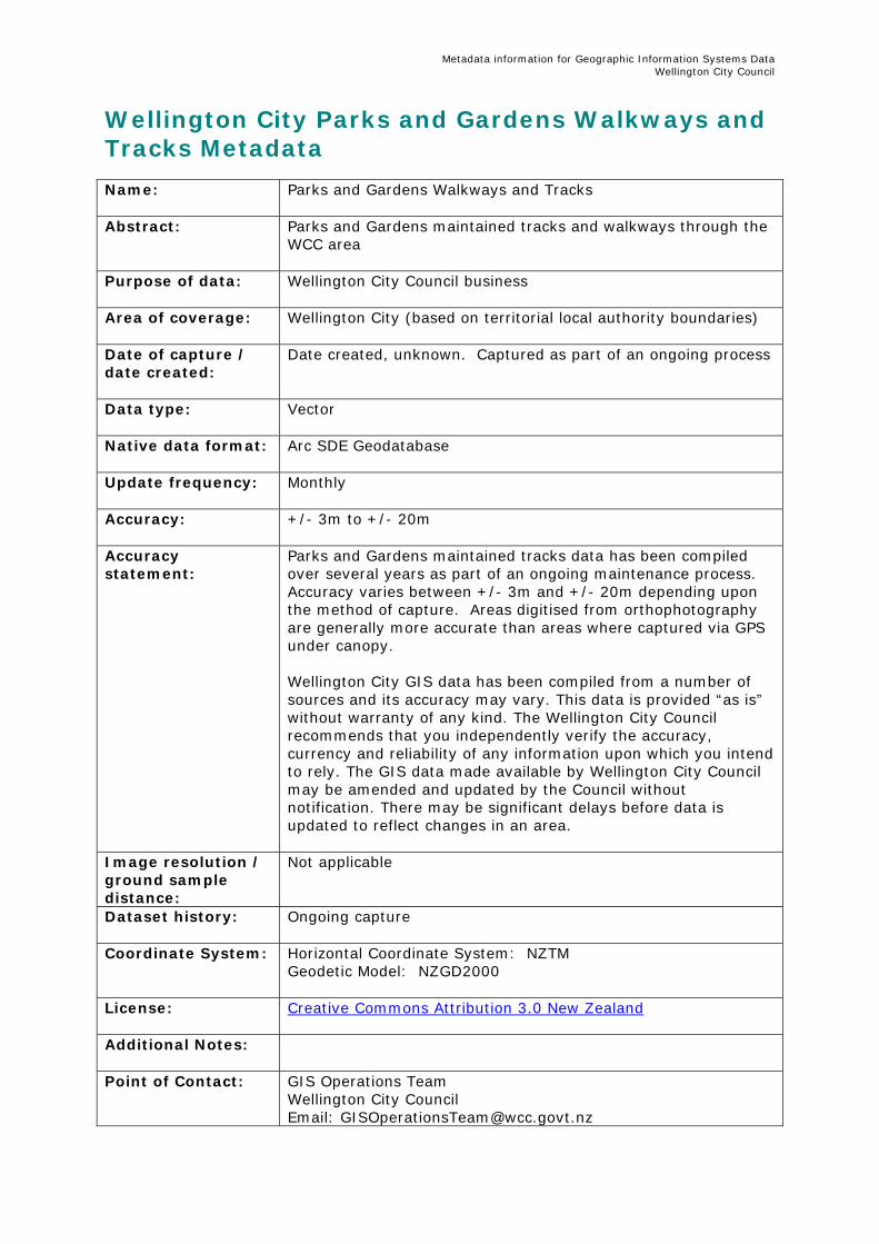
Wellington City Parks and Gardens Walkways and Tracks Metadata Name:
Parks and Gardens Walkways and Tracks
Abstract:
Parks and Gardens maintained tracks and walkways through the WCC area
Purpose of data: Wellington City Council business
Area of coverage:
Wellington City (based on territorial local authority boundaries)
Date of capture / date created:
Date created, unknown. Captured as part of an ongoing process
Data type:
Vector
Native data format: Arc SDE Geodatabase
Update frequency:
Monthly
Accuracy:
+/- 3m to +/- 20m
Accuracy statement:
Parks and Gardens maintained tracks data has been compiled over several years as part of an ongoing maintenance process. Accuracy varies between +/- 3m and +/- 20m depending upon the method of capture. Areas digitised from orthophotography are generally more accurate than areas where captured via GPS under canopy. Wellington City GIS data has been compiled from a number of sources and its accuracy may vary. This data is provided “as is” without warranty of any kind. The Wellington City Council recommends that you independently verify the accuracy, currency and reliability of any information upon which you intend to rely. The GIS data made available by Wellington City Council may be amended and updated by the Council without notification. There may be significant delays before data is updated to reflect changes in an area.
Image resolution / ground sample distance:
Not applicable
Dataset history: Ongoing capture
Coordinate System: Horizontal Coordinate System: NZTM Geodetic Model: NZGD2000
License: Creative Commons Attribution 3.0 New Zealand
Additional Notes:
Point of Contact:
GIS Operations Team Wellington City Council Email: [email protected]

Metadata information for Geographic Information Systems Data Wellington City Council
Phone: (04) 801 4228

Metadata information for Geographic Information Systems Data Wellington City Council
Wellington City Recreation and Leisure Facilities Metadata Name:
Wellington City Recreation and Leisure Facilities
Abstract:
Sportsgrounds, playgrounds, public conveniences, sculptures, lookouts.
Purpose of data: To be displayed on Web Map and for Wellington City Council business
Area of coverage:
Wellington City (based on territorial local authority boundaries)
Date of capture / date created:
Date created unknown. Captured as part of an ongoing process
Data type:
Vector
Native data format: Arc SDE Geodatabase
Update frequency:
Monthly
Accuracy:
Digitised from aerial photography,+/- 3m
Accuracy statement:
Wellington City GIS data has been compiled from a number of sources and its accuracy may vary. This data is provided “as is” without warranty of any kind. The Wellington City Council recommends that you independently verify the accuracy, currency and reliability of any information upon which you intend to rely. The GIS data made available by Wellington City Council may be amended and updated by the Council without notification. There may be significant delays before data is updated to reflect changes in an area.
Image resolution / ground sample distance:
Not applicable
Dataset history: Captured to manage Wellington City Councils Parks and Gardens assets
Coordinate System: Horizontal Coordinate System: NZTM Geodetic Model: NZGD2000
License: Creative Commons Attribution 3.0 New Zealand
Additional Notes:
Point of Contact:
GIS Operations Team Wellington City Council Email: [email protected] Phone: (04) 801 4228
Metadata information for Geographic Information Systems Data Wellington City Council
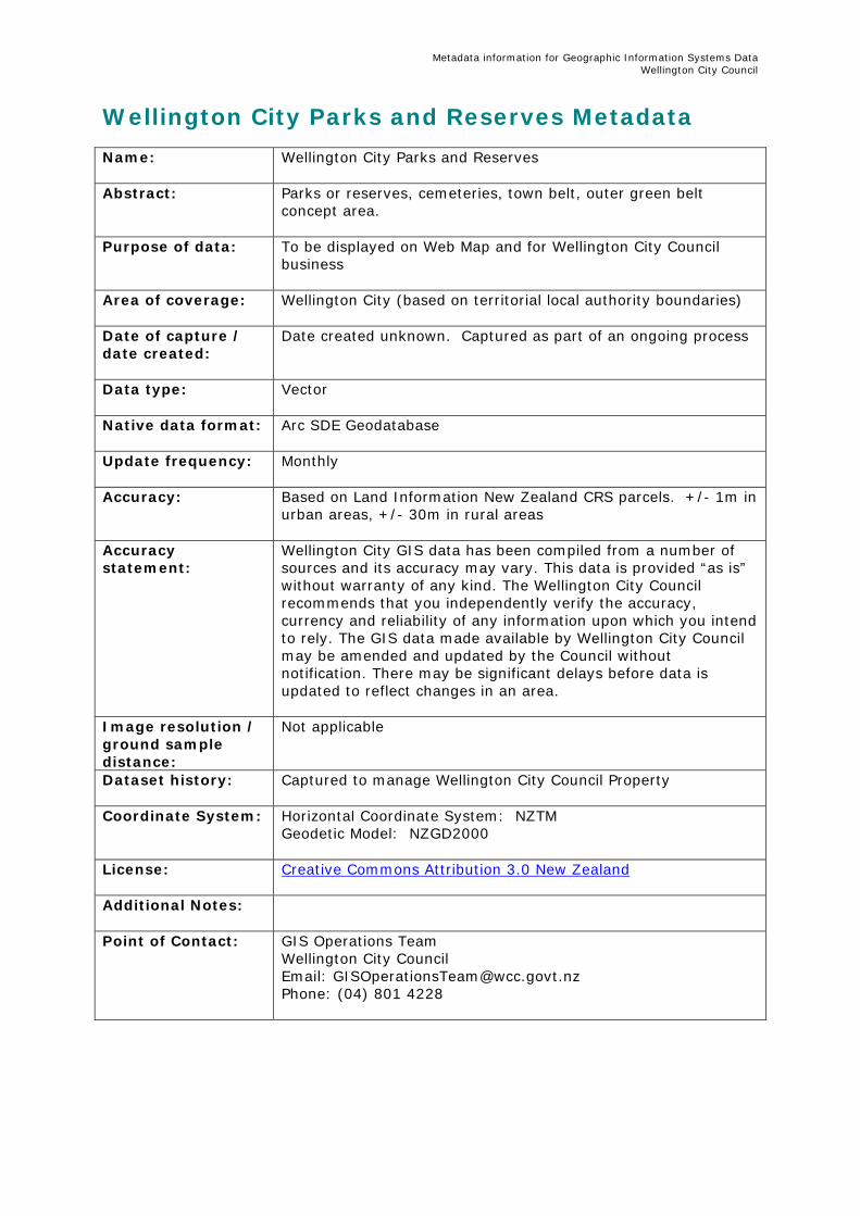
Wellington City Parks and Reserves Metadata Name:
Wellington City Parks and Reserves
Abstract:
Parks or reserves, cemeteries, town belt, outer green belt concept area.
Purpose of data: To be displayed on Web Map and for Wellington City Council business
Area of coverage:
Wellington City (based on territorial local authority boundaries)
Date of capture / date created:
Date created unknown. Captured as part of an ongoing process
Data type:
Vector
Native data format: Arc SDE Geodatabase
Update frequency:
Monthly
Accuracy:
Based on Land Information New Zealand CRS parcels. +/- 1m in urban areas, +/- 30m in rural areas
Accuracy statement:
Wellington City GIS data has been compiled from a number of sources and its accuracy may vary. This data is provided “as is” without warranty of any kind. The Wellington City Council recommends that you independently verify the accuracy, currency and reliability of any information upon which you intend to rely. The GIS data made available by Wellington City Council may be amended and updated by the Council without notification. There may be significant delays before data is updated to reflect changes in an area.
Image resolution / ground sample distance:
Not applicable
Dataset history: Captured to manage Wellington City Council Property
Coordinate System: Horizontal Coordinate System: NZTM Geodetic Model: NZGD2000
License: Creative Commons Attribution 3.0 New Zealand
Additional Notes:
Point of Contact:
GIS Operations Team Wellington City Council Email: [email protected] Phone: (04) 801 4228
Metadata information for Geographic Information Systems Data Wellington City Council
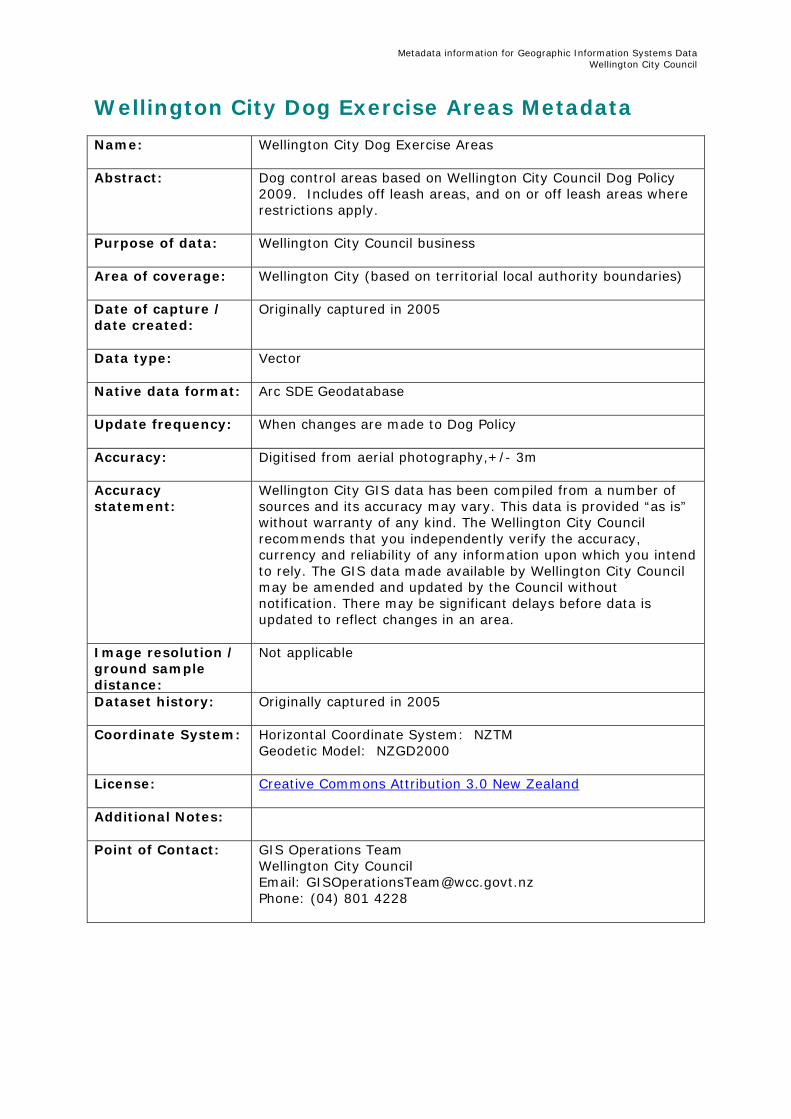
Wellington City Dog Exercise Areas Metadata Name:
Wellington City Dog Exercise Areas
Abstract:
Dog control areas based on Wellington City Council Dog Policy 2009. Includes off leash areas, and on or off leash areas where restrictions apply.
Purpose of data: Wellington City Council business
Area of coverage:
Wellington City (based on territorial local authority boundaries)
Date of capture / date created:
Originally captured in 2005
Data type:
Vector
Native data format: Arc SDE Geodatabase
Update frequency:
When changes are made to Dog Policy
Accuracy:
Digitised from aerial photography,+/- 3m
Accuracy statement:
Wellington City GIS data has been compiled from a number of sources and its accuracy may vary. This data is provided “as is” without warranty of any kind. The Wellington City Council recommends that you independently verify the accuracy, currency and reliability of any information upon which you intend to rely. The GIS data made available by Wellington City Council may be amended and updated by the Council without notification. There may be significant delays before data is updated to reflect changes in an area.
Image resolution / ground sample distance:
Not applicable
Dataset history:
Originally captured in 2005
Coordinate System: Horizontal Coordinate System: NZTM Geodetic Model: NZGD2000
License: Creative Commons Attribution 3.0 New Zealand
Additional Notes:
Point of Contact:
GIS Operations Team Wellington City Council Email: [email protected] Phone: (04) 801 4228
Metadata information for Geographic Information Systems Data Wellington City Council
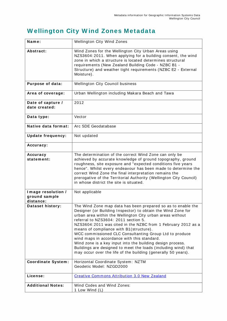
Wellington City Wind Zones Metadata Name:
Wellington City Wind Zones
Abstract:
Wind Zones for the Wellington City Urban Areas using NZS3604:2011. When applying for a building consent, the wind zone in which a structure is located determines structural requirements (New Zealand Building Code - NZBC B1 - Structure) and weather tight requirements (NZBC E2 - External Moisture).
Purpose of data: Wellington City Council business
Area of coverage:
Urban Wellington including Makara Beach and Tawa
Date of capture / date created:
2012
Data type:
Vector
Native data format: Arc SDE Geodatabase
Update frequency:
Not updated
Accuracy:
Accuracy statement:
The determination of the correct Wind Zone can only be achieved by accurate knowledge of ground topography, ground roughness, site exposure and "expected conditions five years hence". Whilst every endeavour has been made to determine the correct Wind Zone the final interpretation remains the prerogative of the Territorial Authority (Wellington City Council) in whose district the site is situated.
Image resolution / ground sample distance:
Not applicable
Dataset history: The Wind Zone map data has been prepared so as to enable the Designer (or Building Inspector) to obtain the Wind Zone for urban area within the Wellington City urban areas without referral to NZS3604: 2011 section 5. NZS3604:2011 was cited in the NZBC from 1 February 2012 as a means of compliance with B1(structure). WCC commissioned CLC Consultanting Group Ltd to produce wind maps in accordance with this standard. Wind zone is a key input into the building design process. Buildings are designed to meet the loads (including wind) that may occur over the life of the building (generally 50 years).
Coordinate System: Horizontal Coordinate System: NZTM Geodetic Model: NZGD2000
License: Creative Commons Attribution 3.0 New Zealand
Additional Notes: Wind Codes and Wind Zones: 1 Low Wind (L)

Metadata information for Geographic Information Systems Data Wellington City Council
2 Medium Wind (M) 3 High Wind (H) 4 Very High Wind (VH) 5 Specific Design (zone outside the scope of NZS3604:2011) (SEG) 6 Extra High (EH) 1000 Unknown
Point of Contact:
GIS Operations Team Wellington City Council Email: [email protected] Phone: (04) 801 4228
Metadata information for Geographic Information Systems Data Wellington City Council
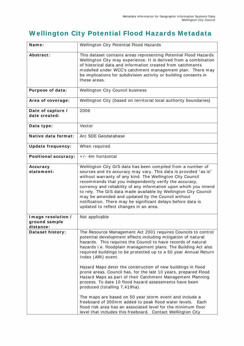
Wellington City Potential Flood Hazards Metadata Name:
Wellington City Potential Flood Hazards
Abstract:
This dataset contains areas representing Potential Flood Hazards Wellington City may experience. It is derived from a combination of historical data and information created from catchments modelled under WCC's catchment management plan. There may be implications for subdivision activity or building consents in these areas.
Purpose of data: Wellington City Council business
Area of coverage:
Wellington City (based on territorial local authority boundaries)
Date of capture / date created:
2006
Data type:
Vector
Native data format: Arc SDE Geodatabase
Update frequency:
When required
Positional accuracy:
+/- 4m horizontal
Accuracy statement:
Wellington City GIS data has been compiled from a number of sources and its accuracy may vary. This data is provided “as is” without warranty of any kind. The Wellington City Council recommends that you independently verify the accuracy, currency and reliability of any information upon which you intend to rely. The GIS data made available by Wellington City Council may be amended and updated by the Council without notification. There may be significant delays before data is updated to reflect changes in an area.
Image resolution / ground sample distance:
Not applicable
Dataset history: The Resource Management Act 2001 requires Councils to control potential development effects including mitigation of natural hazards. This requires the Council to have records of natural hazards i.e. floodplain management plans. The Building Act also required buildings to be protected up to a 50 year Annual Return Index (ARI) event. Hazard Maps deter the construction of new buildings in flood prone areas. Council has, for the last 10 years, prepared Flood Hazard Maps as part of their Catchment Management Planning process. To date 10 flood hazard assessments have been produced (totalling 7,419ha). The maps are based on 50 year storm event and include a freeboard of 300mm added to peak flood water levels. Each flood risk area has an associated level for the minimum floor level that includes this freeboard. Contact Wellington City
Metadata information for Geographic Information Systems Data Wellington City Council
Council for more information about minimum floor levels. Potential Flood Hazard areas were modelled in MIKE21 using a 4m grid size. Results were then smoothed using 100mm contours derived from a WCC 2m DTM.
Coordinate System: Horizontal Coordinate System: NZTM Geodetic Model: NZGD2000
License: Creative Commons Attribution 3.0 New Zealand
Additional Notes:
Point of Contact:
GIS Operations team Wellington City Council Email: [email protected] Phone: (04) 801 4228
Metadata information for Geographic Information Systems Data Wellington City Council
Wellington City Tsunami Evacuation Zones Metadata Name:
Wellington City Tsunami Evacuation Zones
Abstract:
The evacuation zones are designed to encompass the range of inundation patterns for many individual possible tsunami. The use of tsunami evacuation areas/zones has the advantage of simplicity for emergency planning, public awareness and understanding.
Purpose of data: Civil Defence Emergency Management
Area of coverage:
Wellington TLA’s coastline
Date of capture / date created:
December 2009
Data type:
Vector
Native data format: Shapefile
Update frequency:
Ad-hoc or if spatial/attribute details need to be revised by GNS Science/GWRC or the Wellington Regional CDEM Group.
Accuracy:
Not applicable
Accuracy statement:
Wellington City GIS data has been compiled from a number of sources and its accuracy may vary. This data is provided “as is” without warranty of any kind. The Wellington City Council recommends that you independently verify the accuracy, currency and reliability of any information upon which you intend to rely. The GIS data made available by Wellington City Council may be amended and updated by the Council without notification. There may be significant delays before data is updated to reflect changes in an area.
Image resolution / ground sample distance:
Not applicable
Dataset history: Primary input were the tsunami inundation areas created with GNS Science/GWRC and Wellington Regional CDEM Group analysis. The evacuation zones serve to illustrate evacuation bands into manageable shapes (i.e to follow a road, block of houses etc). First provided to WCC in March 2009, update received in December 2009 to include additional attributes.
Coordinate System: Horizontal Coordinate System: NZTM Geodetic Model: NZGD2000
License: Creative Commons Attribution - No Derivative Works 3.0 New Zealand
Additional Notes: The use of at least two and a maximum of three evacuation areas is recommended for nationally consistent tsunami planning

Metadata information for Geographic Information Systems Data Wellington City Council
in New Zealand communities. The recommended standard for distinguishing the three evacuation zones on evacuation maps is the use of the colours red, orange and yellow. For more information, visit the Civil Defence Tsunami Evacuation Zones Guideline document.
Point of Contact:
GIS Operations Team Wellington City Council Email: [email protected] Phone: (04) 801 4228
Metadata information for Geographic Information Systems Data Wellington City Council
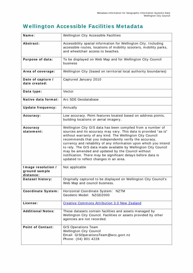
Wellington Accessible Facilities Metadata Name:
Wellington City Accessible Facilities
Abstract:
Accessibility spatial information for Wellington City. Including accessible routes, locations of mobility scooters, mobility parks, and wheelchair access to beaches.
Purpose of data: To be displayed on Web Map and for Wellington City Council business
Area of coverage:
Wellington City (based on territorial local authority boundaries)
Date of capture / date created:
Captured January 2010
Data type:
Vector
Native data format: Arc SDE Geodatabase
Update frequency:
Annually
Accuracy:
Low accuracy. Point features located based on address points, building locations or aerial imagery.
Accuracy statement:
Wellington City GIS data has been compiled from a number of sources and its accuracy may vary. This data is provided “as is” without warranty of any kind. The Wellington City Council recommends that you independently verify the accuracy, currency and reliability of any information upon which you intend to rely. The GIS data made available by Wellington City Council may be amended and updated by the Council without notification. There may be significant delays before data is updated to reflect changes in an area.
Image resolution / ground sample distance:
Not applicable
Dataset history: Originally captured to be displayed on Wellington City Council’s Web Map and council business.
Coordinate System: Horizontal Coordinate System: NZTM Geodetic Model: NZGD2000
License: Creative Commons Attribution 3.0 New Zealand
Additional Notes: These datasets contain facilities and assets managed by Wellington City Council. Facilities or assets provided by other agencies are not recorded.
Point of Contact:
GIS Operations Team Wellington City Council Email: [email protected] Phone: (04) 801 4228
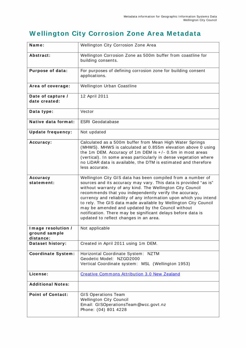
Metadata information for Geographic Information Systems Data Wellington City Council
Wellington City Corrosion Zone Area Metadata Name:
Wellington City Corrosion Zone Area
Abstract:
Wellington Corrosion Zone as 500m buffer from coastline for building consents.
Purpose of data: For purposes of defining corrosion zone for building consent applications.
Area of coverage:
Wellington Urban Coastline
Date of capture / date created:
12 April 2011
Data type:
Vector
Native data format: ESRI Geodatabase
Update frequency:
Not updated
Accuracy:
Calculated as a 500m buffer from Mean High Water Springs (MHWS). MHWS is calculated at 0.855m elevation above 0 using the 1m DEM. Accuracy of 1m DEM is +/- 0.5m in most areas (vertical). In some areas particularly in dense vegetation where no LiDAR data is available, the DTM is estimated and therefore less accurate.
Accuracy statement:
Wellington City GIS data has been compiled from a number of sources and its accuracy may vary. This data is provided “as is” without warranty of any kind. The Wellington City Council recommends that you independently verify the accuracy, currency and reliability of any information upon which you intend to rely. The GIS data made available by Wellington City Council may be amended and updated by the Council without notification. There may be significant delays before data is updated to reflect changes in an area.
Image resolution / ground sample distance:
Not applicable
Dataset history: Created in April 2011 using 1m DEM.
Coordinate System: Horizontal Coordinate System: NZTM Geodetic Model: NZGD2000 Vertical Coordinate system: MSL (Wellington 1953)
License: Creative Commons Attribution 3.0 New Zealand
Additional Notes:
Point of Contact:
GIS Operations Team Wellington City Council Email: [email protected] Phone: (04) 801 4228
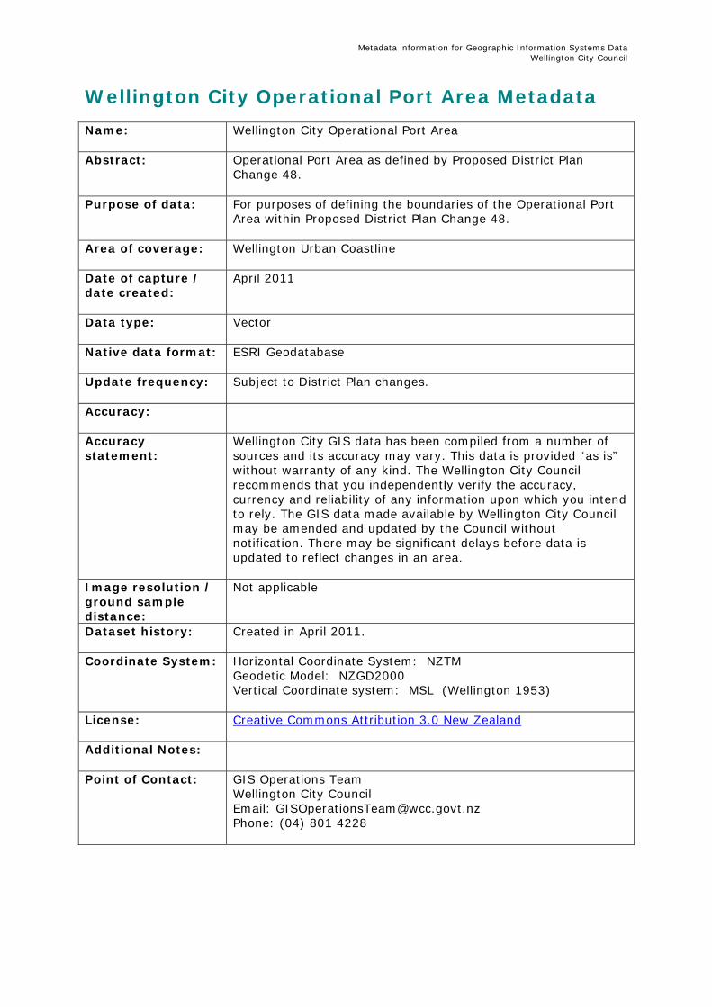
Metadata information for Geographic Information Systems Data Wellington City Council
Wellington City Operational Port Area Metadata Name:
Wellington City Operational Port Area
Abstract:
Operational Port Area as defined by Proposed District Plan Change 48.
Purpose of data: For purposes of defining the boundaries of the Operational Port Area within Proposed District Plan Change 48.
Area of coverage:
Wellington Urban Coastline
Date of capture / date created:
April 2011
Data type:
Vector
Native data format: ESRI Geodatabase
Update frequency:
Subject to District Plan changes.
Accuracy:
Accuracy statement:
Wellington City GIS data has been compiled from a number of sources and its accuracy may vary. This data is provided “as is” without warranty of any kind. The Wellington City Council recommends that you independently verify the accuracy, currency and reliability of any information upon which you intend to rely. The GIS data made available by Wellington City Council may be amended and updated by the Council without notification. There may be significant delays before data is updated to reflect changes in an area.
Image resolution / ground sample distance:
Not applicable
Dataset history: Created in April 2011.
Coordinate System: Horizontal Coordinate System: NZTM Geodetic Model: NZGD2000 Vertical Coordinate system: MSL (Wellington 1953)
License: Creative Commons Attribution 3.0 New Zealand
Additional Notes:
Point of Contact:
GIS Operations Team Wellington City Council Email: [email protected] Phone: (04) 801 4228

Metadata information for Geographic Information Systems Data Wellington City Council
Wellington City Buildings Metadata Name:
Wellington City Buildings
Abstract:
Boundary area definition of Wellington City Council Buildings as located on Wellington City Council sites.
Purpose of data: For purposes of recording the physical boundaries of Wellington City Council building assets.
Area of coverage:
Wellington City (based on territorial local authority boundaries)
Date of capture / date created:
11 May 2011
Data type:
Vector
Native data format: ESRI Geodatabase
Update frequency:
Dataset updated on an ad hoc basis as notifications are received from Property.
Accuracy:
Captured using aerial photography + / - 0.1m. Buildings based on the 2D Building Footprint layer
Accuracy statement:
Wellington City GIS data has been compiled from a number of sources and its accuracy may vary. This data is provided “as is” without warranty of any kind. The Wellington City Council recommends that you independently verify the accuracy, currency and reliability of any information upon which you intend to rely. The GIS data made available by Wellington City Council may be amended and updated by the Council without notification. There may be significant delays before data is updated to reflect changes in an area.
Image resolution / ground sample distance:
Not applicable
Dataset history: Created in May 2011.
Coordinate System: Horizontal Coordinate System: NZTM Geodetic Model: NZGD2000 Vertical Coordinate system: MSL (Wellington 1953)
License: Creative Commons Attribution 3.0 New Zealand
Additional Notes:
Point of Contact:
GIS Operations Team Wellington City Council Email: [email protected] Phone: (04) 801 4228
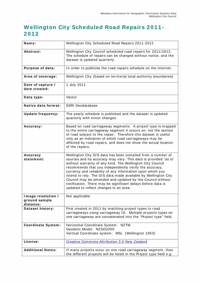
Metadata information for Geographic Information Systems Data Wellington City Council
Wellington City Scheduled Road Repairs 2011-2012 Name:
Wellington City Scheduled Road Repairs 2011-2012
Abstract:
Wellington City Council scheduled road repairs for 2011/2012. The schedule of repairs can be changed without notice, and the dataset is updated quarterly.
Purpose of data: In order to publicise the road repairs schedule on the internet.
Area of coverage:
Wellington City (based on territorial local authority boundaries)
Date of capture / date created:
1 July 2011
Data type:
Vector
Native data format: ESRI Geodatabase
Update frequency:
The yearly schedule is published and the dataset is updated quarterly with minor changes.
Accuracy:
Based on road carriageway segments. A project type is mapped to the entire carriageway segment it occurs on, not the section of road subject to the repair. Therefore this dataset is useful only as an indication of which road carriageways may be affected by road repairs, and does not show the actual location of the repairs.
Accuracy statement:
Wellington City GIS data has been compiled from a number of sources and its accuracy may vary. This data is provided “as is” without warranty of any kind. The Wellington City Council recommends that you independently verify the accuracy, currency and reliability of any information upon which you intend to rely. The GIS data made available by Wellington City Council may be amended and updated by the Council without notification. There may be significant delays before data is updated to reflect changes in an area.
Image resolution / ground sample distance:
Not applicable
Dataset history: First created in 2011 by matching project types to road carriageways using carriageway ID. Multiple projects types on one carriageway are concatenated into the “Project type” field.
Coordinate System: Horizontal Coordinate System: NZTM Geodetic Model: NZGD2000 Vertical Coordinate system: MSL (Wellington 1953)
License: Creative Commons Attribution 3.0 New Zealand
Additional Notes: If many projects occur on one road carriageway segment, then the different projects will be listed in the Project type field e.g.
Metadata information for Geographic Information Systems Data Wellington City Council
“Road Resurfacing, Minor Safety”. The Symbol field indicates “Mixed” if there are multiple projects, otherwise records the one project type. There is more information about the maintenance programme on council website here: http://www.wellington.govt.nz/services/rdstraffic/maintpro/maintpro.html
Point of Contact:
GIS Operations Team Wellington City Council Email: [email protected] Phone: (04) 801 4228 Kai Chan Transport Assets Programme Coordinator Email: [email protected] Phone: (04) 499 4444
Metadata information for Geographic Information Systems Data Wellington City Council
Wellington City CBD Taxi Stands Metadata Name:
Wellington City CBD Taxi Stands
Abstract:
All taxi stands within the Wellington CBD.
Purpose of data: Wellington City Council business
Area of coverage:
Wellington City CBD
Date of capture / date created:
31 January 2011
Data type:
Vector
Native data format: ESRI Geodatabase
Update frequency:
6 monthly as needed
Accuracy:
Digitised from aerial photography,+/- 3m
Accuracy statement:
Wellington City GIS data has been compiled from a number of sources and its accuracy may vary. This data is provided “as is” without warranty of any kind. The Wellington City Council recommends that you independently verify the accuracy, currency and reliability of any information upon which you intend to rely. The GIS data made available by Wellington City Council may be amended and updated by the Council without notification. There may be significant delays before data is updated to reflect changes in an area.
Image resolution / ground sample distance:
Not applicable
Dataset history: The development of this dataset was driven by the requests received from the general public. The Taxi Stand data were sourced from the reconfirmation of Traffic Resolution that went before Wellington City Council in September 2009. The data were reviewed and updated from the Infrastructure database - RAMM (Road Assessment and Maintenance Management). The dataset was created on 31 January 2011 and will be maintained by the Infrastructure Planning and Data Team.
Coordinate System: Horizontal Coordinate System: NZTM Geodetic Model: NZGD2000 Vertical Coordinate system: MSL (Wellington 1953)
License: Creative Commons Attribution 3.0 New Zealand
Additional Notes:
Point of Contact:
GIS Operations Team Wellington City Council Email: [email protected] Phone: (04) 801 4228

Metadata information for Geographic Information Systems Data Wellington City Council
Asset Data Administrator Infrastructure Planning and Data Wellington City Council Email: [email protected] Phone: (04) 499 4444
Metadata information for Geographic Information Systems Data Wellington City Council
Wellington Historic Thomas Ward Maps Name:
Wellington Historic Thomas Ward Maps
Abstract:
Thomas Ward, a licensed surveyor and civil engineer, was contracted in 1889 to produce a detailed map of Wellington central city.
The maps show legal boundaries of properties and streets, buildings and what they were constructed of, street-lamp and fireplug locations.
Purpose of data: Information about early Wellington
Area of coverage:
Wellington City CBD
Date of capture / date created:
January 1891 (digitised and published July 2011)
Data type:
Raster
Native data format: Uncompressed Tiff / ESRI tfw
Update frequency:
Not updated
Accuracy:
The rectification of the Thomas Ward maps was completed by the GIS Operations Team at Wellington City Council. As the scanned images had some skew, the rectification process was unable to be carried out to a high level of accuracy. The quality of the rectification of the images also depends on the accuracy of the 2011 cadastre vector data which was used as base data as well as the content coverage of the maps to find sufficient and reliable reference points. Please note that a best-fit recitfication over each individual map sheet was attempted, so generally the whole sheet is located correctly, but accuracy of features at any particular location may be slightly misaligned. The geofereferenced Thomas Ward maps should only be used as a guide as to the location of historic features.
Accuracy statement:
Wellington City GIS data has been compiled from a number of sources and its accuracy may vary. This data is provided “as is” without warranty of any kind. The Wellington City Council recommends that you independently verify the accuracy, currency and reliability of any information upon which you intend to rely. The GIS data made available by Wellington City Council may be amended and updated by the Council without notification. There may be significant delays before data is updated to reflect changes in an area.
Image resolution / ground sample distance:
0.08m
Dataset history: Thomas Ward - Authorised Surveyors: Map of the City of Wellington - January 1891- clipped, georeferenced and rectified
Metadata information for Geographic Information Systems Data Wellington City Council
in July 2011 Thomas Ward, a licensed surveyor and civil engineer, was contracted in 1889 to produce a detailed map of Wellington central city. Over three years, Ward collected information and compiled it into scale map tiles. The maps show legal boundaries of properties and streets, buildings and what they were constructed of, street-lamp and fireplug locations. The Thomas Ward survey map provides much information about early Wellington. Where building records are not complete, the map is useful for discovering whether present-day buildings were in existence before 1892. It also hints at the nature of the late 19th century city where high-density housing is evident in some parts. The rectification of the Thomas Ward maps was completed by the GIS Operations Team at Wellington City Council in 2011. As the scanned images had some skew, the rectification process was unable to be carried out to a high level of accuracy. The quality of the rectification of the images also depends on the accuracy of the 2011 cadastre vector data which was used as base data as well as the content coverage of the maps to find sufficient and reliable reference points. Please note that a best-fit recitfication over each individual map sheet was attempted, so generally the whole sheet is located correctly, but accuracy of features at any particular location may be slightly misaligned. The geofereferenced Thomas Ward maps should only be used as a guide as to the location of historic features.
Coordinate System: Horizontal Coordinate System: NZTM Geodetic Model: NZGD2000
License: Creative Commons Attribution 3.0 New Zealand
Additional Notes:
Point of Contact:
GIS Operations Team Wellington City Council Email: [email protected] Phone: (04) 801 4228
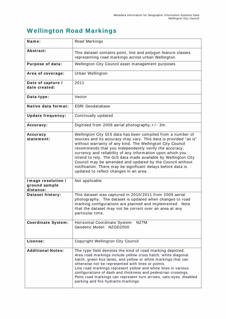
Metadata information for Geographic Information Systems Data Wellington City Council
Wellington Road Markings Name:
Road Markings
Abstract:
This dataset contains point, line and polygon feature classes representing road markings across urban Wellington.
Purpose of data: Wellington City Council asset management purposes
Area of coverage:
Urban Wellington
Date of capture / date created:
2011
Data type:
Vector
Native data format: ESRI Geodatabase
Update frequency:
Continually updated
Accuracy:
Digitised from 2009 aerial photography,+/- 3m.
Accuracy statement:
Wellington City GIS data has been compiled from a number of sources and its accuracy may vary. This data is provided “as is” without warranty of any kind. The Wellington City Council recommends that you independently verify the accuracy, currency and reliability of any information upon which you intend to rely. The GIS data made available by Wellington City Council may be amended and updated by the Council without notification. There may be significant delays before data is updated to reflect changes in an area.
Image resolution / ground sample distance:
Not applicable
Dataset history: This dataset was captured in 2010/2011 from 2009 aerial photography. The dataset is updated when changes to road marking configurations are planned and implemented. Note that the dataset may not be correct over an area at any particular time.
Coordinate System: Horizontal Coordinate System: NZTM Geodetic Model: NZGD2000
License: Copyright Wellington City Council
Additional Notes: The type field denotes the kind of road marking depicted. Area road markings include yellow cross hatch, white diagonal hatch, green bus lanes, and yellow or white markings that can otherwise not be represented with lines or points. Line road markings represent yellow and white lines in various configurations of dash and thickness and pedestrian crossings. Point road markings can represent turn arrows, cats-eyes, disabled parking and fire hydrants markings.

Metadata information for Geographic Information Systems Data Wellington City Council
Point of Contact:
GIS Operations Team Wellington City Council Email: [email protected] Phone: (04) 801 4228
Metadata information for Geographic Information Systems Data Wellington City Council
Wellington Heritage Features Name:
Heritage Features
Abstract:
The heritage objects and buildings datasets identify buildings, objects with particular emotional, historical, design or technological significance.
Heritage trees represent individual and groups of trees within the City which have ecological, amenity or heritage value.
Maori sites denote sites of significance to tangata whenua for a variety of reasons. These may have particular historical significance, act as a marker on the landscape or be an example of a particular type of site. For example maunga (hills), pa, kainga (small village), waahi tapu (sacred site), waahi tupuna (ancestral site), taurnga waka (canoe landing site), puna (springs), ngakina (gardens) or ana tupa paku (burial caves).
Purpose of data: Wellington City Council District Planning
Area of coverage:
Urban Wellington
Date of capture / date created:
Unknown
Data type:
Vector
Native data format: ESRI Geodatabase
Update frequency:
Updated intermittently
Accuracy:
Digitised from aerial photography,+/- 3m.
Accuracy statement:
Wellington City GIS data has been compiled from a number of sources and its accuracy may vary. This data is provided “as is” without warranty of any kind. The Wellington City Council recommends that you independently verify the accuracy, currency and reliability of any information upon which you intend to rely. The GIS data made available by Wellington City Council may be amended and updated by the Council without notification. There may be significant delays before data is updated to reflect changes in an area.
Image resolution / ground sample distance:
Not applicable
Dataset history: Coordinate System: Horizontal Coordinate System: NZTM
Geodetic Model: NZGD2000
License: Copyright Wellington City Council
Additional Notes: Information concerning the cultural heritage of each listed item is contained in the Council's Schedule of Heritage Areas, buildings, Objects, Trees & Maori Sites, in Volume 1, Chapter 21

Metadata information for Geographic Information Systems Data Wellington City Council
of the District Plan.
Point of Contact:
GIS Operations Team Wellington City Council Email: [email protected] Phone: (04) 801 4228
Metadata information for Geographic Information Systems Data Wellington City Council
Wellington Infrastructure Roading Assets Name:
Infrastructure roading assets
Abstract:
Road catagories, road carriageways, street furniture, street lights, traffic islands
Purpose of data: Wellington City Council Infrastructure Asset Management
Area of coverage:
Urban Wellington
Date of capture / date created:
Unknown
Data type:
Vector
Native data format: ESRI Geodatabase
Update frequency:
Updated intermittently
Accuracy:
Unknown
Accuracy statement:
WARNING – street furniture, street lights and traffic islands may be very out of date. Wellington City GIS data has been compiled from a number of sources and its accuracy may vary. This data is provided “as is” without warranty of any kind. The Wellington City Council recommends that you independently verify the accuracy, currency and reliability of any information upon which you intend to rely. The GIS data made available by Wellington City Council may be amended and updated by the Council without notification. There may be significant delays before data is updated to reflect changes in an area.
Image resolution / ground sample distance:
Not applicable
Dataset history: Coordinate System: Horizontal Coordinate System: NZTM
Geodetic Model: NZGD2000
License: Copyright Wellington City Council
Additional Notes: Point of Contact:
GIS Operations Team Wellington City Council Email: [email protected] Phone: (04) 801 4228
Metadata information for Geographic Information Systems Data Wellington City Council
Wellington City Buildings Solar Radiation Metadata Name:
Wellington City Buildings Solar Radiation
Abstract:
Indicative solar radiation for Wellington buildings. This dataset was created for indicative purposes to raise public awareness and promote sustainable energy. There is no guarantee of accuracy within the indicated radiation levels in this dataset. There are many assumptions which include:- average solar radiation for each building is for the roof surface only, not vertical walls- area values are in terms of 2d area (horizontal area)- many buildings are modelled with a flat roof due to limited 3D information for buildings in some areas- some buildings were not included or may be inaccurate due to the age of building information compared with building activity- cloud cover and distant topography variables were limited in the scope of the analysis due to data processing performance factors- vegetation was excluded from the focus of the analysis so buildings may have significantly lower solar radiation in some instances- solar radiation calculated using a 1m Digital Elevation Model. On-site field solar radiation readings should be taken to establish true radiation levels for scoping available energy or return of investment on any solar asset installation. This dataset only serves as an indicative guide. Wellington City Council may require resource consent and/or building consents to be issued before installation of solar energy harnessing equipment - check with the Council before installing. Ensure all electrical work is carried out by a qualified electrician.
Purpose of data:
Wellington City Council business
Area of coverage:
Urban areas of Wellington
Date of capture / date created:
Data created May 2012
Data type:
Vector (direct and total radiation) and Raster (direct radiation)
Native data format:
ESRI File Geodatabase Raster format
Update frequency:
No update schedule
Accuracy:
Wellington City Council does not guarantee the accuracy of solar radiation for buildings.
Accuracy statement:
Wellington City GIS data has been compiled from a number of sources and its accuracy may vary. This data is provided “as is” without warranty of any kind. The Wellington City Council recommends that you independently verify the accuracy, currency and reliability of any information upon which you intend to rely. The GIS data made available by Wellington City Council may be amended and updated by the Council without notification. There may be significant delays before data is updated to reflect changes in an area.
Metadata information for Geographic Information Systems Data Wellington City Council
Image resolution / ground sample distance:
1m
Dataset history:
This process required ArcGIS ArcInfo license, 3D Analyst and Spatial Analyst extensions, as well as some custom tools and python scripts. 1. Loaded 3D buildings data into the 1m DEM of Wellington urban areas. A custom tool is available for this: http://resources.arcgis.com/gallery/file/java/details?entryID=2929E846-1422-2418-A0DD-16627D87B471 2. Also loaded 3D buildings from 2004, and then 2D buildings extruded to estimated height where no 3D data available. 3. DEM was clipped into 10 tiles covering the Wellington urban areas, with large overlaps to reduce error around tile boundaries. 4. Each tile was run through the 'Area Solar Radiation' tool in Spatial Analyst using the following parameters (batch processed): Latitude: -41 Sky size: 200 Time configuration: WholeYear 2012 Day interval: 14 Hour interval: 0.5 Each interval: NOINTERVAL Z factor: 1 Slope aspect input type: FROM_DEM Calculation directions: 32 Zenith divisions: 8 Azimuth divisions: 8 Diffuse model type: "UNIFORM_SKY" Diffuse proportion: 0.3 Transmittivity: 0.5 5. Multipatch footprints of the buildings were used to extract average & max solar radiation for 'global' and 'direct' radiation rasters. 6. Buildings within the overlap areas of tiles were manually selected to participate in the analysis of a specific tile. 7. Each building was converted to raster and calculated using Spatial Analyst Zonal Statistics tool, mosaic into 1 raster, then converted back to vector. 8. The vector layers were joined back to a master file to display 4 values: Max direct, Average direct, Max global, Average global. 9. The direct solar radiation raster was used to symbolise solar radiation.
Coordinate System:
Horizontal Coordinate System: NZTM Geodetic Model: NZGD2000 Vertical Coordinate system: MSL (Wellington 1953)
License: Creative Commons Attribution 3.0 New Zealand

Metadata information for Geographic Information Systems Data Wellington City Council
Additional Notes:
Solar radiation information should not be used for detailed engineering design.
Point of Contact:
GIS Operations Team Wellington City Council Email: [email protected] Phone: (04) 801 4228