west flemish pass exploration drilling project: project
TRANSCRIPT

West Flemish Pass Exploration Drilling Project: Project Description Summary
Prepared for: Chevron Canada Limited
Prepared by: Stantec Consulting Ltd. 141 Kelsey Drive St. John’s, NL A1B 0L2 Tel: (709) 576-1458 Fax: (709) 576-2126
File No: 121415690
Report
October 22, 2018

WEST FLEMISH PASS EXPLORATION DRILLING PROJECT: PROJECT DESCRIPTION SUMMARY
i
Table of Contents
ABBREVIATIONS .....................................................................................................................III
1.0 INTRODUCTION ............................................................................................................ 1 1.1 PROJECT CONTEXT AND OBJECTIVES ..................................................................... 1 1.2 PROPONENT INFORMATION ....................................................................................... 1 1.3 REGULATORY CONTEXT ............................................................................................. 2
2.0 PROJECT DESCRIPTION ............................................................................................. 3 2.1 PROJECT LOCATION ................................................................................................... 3 2.2 PROJECT COMPONENTS AND ACTIVITIES ................................................................ 3
2.2.1 Vertical Seismic Profiling ................................................................................ 7 2.2.2 Well Evaluation and Testing ........................................................................... 7 2.2.3 Well Abandonment ......................................................................................... 8 2.2.4 Supply and Servicing ..................................................................................... 8
2.3 EMISSIONS, DISCHARGES AND WASTE MANAGEMENT .......................................... 9 2.3.1 Atmospheric Emissions .................................................................................. 9 2.3.2 Underwater Sound ....................................................................................... 10 2.3.3 Drilling Waste ............................................................................................... 10 2.3.4 Liquid Discharges ......................................................................................... 11 2.3.5 Hazardous and Non-Hazardous Solid Wastes ............................................. 11
2.4 PROJECT SCHEDULE .................................................................................................11 2.5 POTENTIAL ACCIDENTAL EVENTS ............................................................................12
3.0 ENVIRONMENTAL SETTING .......................................................................................12 3.1 PHYSICAL ENVIRONMENT .........................................................................................12 3.2 BIOLOGICAL ENVIRONMENT......................................................................................13 3.3 HUMAN ENVIRONMENT ..............................................................................................19 3.4 EXISTING ENVIRONMENTAL STUDIES ......................................................................21
4.0 CONSULTATION AND ENGAGEMENT .......................................................................22 4.1 INDIGENOUS ENGAGEMENT......................................................................................22 4.2 STAKEHOLDER ENGAGEMENT ..................................................................................23
4.2.1 Government and Regulatory Stakeholders ................................................... 23
5.0 POTENTIAL PROJECT-RELATED CHANGES TO THE ENVIRONMENT AND SCOPING CONSIDERATIONS .....................................................................................30
5.1 ROUTINE PROJECT ACTIVITIES ................................................................................30 5.2 NON-ROUTINE PROJECT ACTIVITIES .......................................................................33 5.3 SCOPING CONSIDERATIONS .....................................................................................35
6.0 REFERENCES ..............................................................................................................36

WEST FLEMISH PASS EXPLORATION DRILLING PROJECT: PROJECT DESCRIPTION SUMMARY
ii
LIST OF TABLES Table 1 Project Area Coordinates ............................................................................................. 3 Table 2 Special Areas in the Eastern Newfoundland Offshore Area ........................................15 Table 3 Summary of Engagement to Date (as of October 19, 2018) ........................................25 Table 4 Potential Environmental Interactions with Routine Project Activities ...........................30 Table 5 Potential Environmental Interactions with Non-routine Project Activities .....................33
LIST OF FIGURES Figure 1 Project Area ................................................................................................................. 4 Figure 2 Illustration of Drill Ship (front) and Semi-submersible (back) ........................................ 5 Figure 3 Schematic of a Floating Rig While Drilling in a Closed Loop Circulating System .......... 6 Figure 4 Special Areas .............................................................................................................18 Figure 5 Commercial Fishing Activity in the Project Area and Surrounding Areas .....................20

WEST FLEMISH PASS EXPLORATION DRILLING PROJECT: PROJECT DESCRIPTION SUMMARY
iii
Abbreviations
Accord Acts Canada-Newfoundland and Labrador Atlantic Accord Implementation Act and the Canada-Newfoundland and Labrador Atlantic Accord Implementation Newfoundland and Labrador Act
ADW Approval to Drill a Well ASP Association of Seafood Producers BHA Bottom Hole Assembly BOP BOP Blow-out Preventer CEAA 2012 Canadian Environmental Assessment Act, 2012 CEA Agency Canadian Environmental Assessment Agency C-NLOPB Canada-Newfoundland and Labrador Offshore Petroleum Board CO Carbon Monoxide CO2 Carbon Dioxide CO2e Carbon Dioxide Equivalent COSEWIC Committee on the Status of Endangered Wildlife in Canada DFO Fisheries and Oceans Canada DND Department of National Defence EA Environmental Assessment EBSA Ecologically and Biologically Significant Area ECCC Environment and Climate Change Canada EEM Environmental Effects Monitoring EEZ Exclusive Economic Zone EIS Environmental Impact Statement EL Exploration Licence FFAW-Unifor Fisheries, Food and Allied Workers FSC Food, Social and Ceremonial GEAC Groundfish Enterprise Allocation Council GHGs Greenhouse Gases IBAs Important Bird Areas km Kilometre MARPOL International Convention for the Prevention of Pollution from Ships m Metre MODU Mobile Offshore Drilling Unit MPA Marine Protected Area NAFO Northwest Atlantic Fisheries Organization NL Newfoundland and Labrador nm Nautical Mile NOX Nitrogen Oxides NGO Non-governmental Organization

WEST FLEMISH PASS EXPLORATION DRILLING PROJECT: PROJECT DESCRIPTION SUMMARY
iv
NRCAN Natural Resources Canada OA Operations Authorization OCI Ocean Choice International OWTG Offshore Waste Treatment Guidelines PM Particulate Matter The Project West Flemish Pass Exploration Drilling Project PSV Project supply vessel ROV Remotely Operated Vehicle SARA Canadian Species at Risk Act SBM Synthetic-based Drilling Mud SEA Strategic Environmental Assessment SO2 Sulfur Dioxide UTM Universal Transverse Mercator VC Valued Component VME Vulnerable Marine Ecosystem VSP Vertical Seismic Profile WBM Water-based Drilling Mud

WEST FLEMISH PASS EXPLORATION DRILLING PROJECT: PROJECT DESCRIPTION SUMMARY
October 22, 2018
1
1.0 INTRODUCTION
Chevron proposes to conduct an exploration drilling program on Exploration Licence (EL) 1138 in the Flemish Pass area (the West Flemish Pass Exploration Drilling Project; the Project). The Project may involve drilling up to eight exploration and delineation / appraisal wells over the term of the EL (2021 to 2030), with an initial well proposed to be drilled in 2021 pending regulatory approval.
The drilling, testing, and abandonment of offshore exploratory wells, under certain circumstances, is a designated project under the Canadian Environmental Assessment Act, 2012 (CEAA 2012). This Project Description has been prepared to address the information requirements pursuant to the CEAA 2012 and its regulations, as well as requirements under the Canada-Newfoundland and Labrador Atlantic Accord Implementation Act and the Canada-Newfoundland and Labrador Atlantic Accord Implementation Newfoundland and Labrador Act (the Accord Acts). It also assists regulatory agencies, Indigenous organizations, and stakeholders in identifying potential interests in the Project for consideration during Project planning and the environmental assessment (EA) review process, as required. This Project Description Summary is provided to the Canadian Environmental Assessment Agency (CEA Agency) so that it may determine whether an EA is required.
1.1 PROJECT CONTEXT AND OBJECTIVES
The Project includes the drilling and abandonment of exploration wells using a mobile offshore drilling unit (MODU). It may involve drilling up to eight exploration and delineation / appraisal wells over nine years (2021 to 2030), with an initial well proposed to be drilled in 2021 pending regulatory approval. The Project is located in the eastern region of the Newfoundland and Labrador (NL) offshore area.
The Project includes activities associated with offshore exploration drilling and there is no production capacity associated with the Project.
1.2 PROPONENT INFORMATION
Communications regarding the environmental assessment for the Project should be directed to the following contacts:
Gordon Miller Exploration Manager Chevron Canada Resources Limited 500 - Fifth Avenue SW Calgary, AB T2P 0L7 403-234- 5652 [email protected]
Michelle Gilders Regulatory & Environmental Lead Chevron Canada Resources Limited 500 - Fifth Avenue SW Calgary, AB T2P 0L7 403-234- 5092 [email protected]
WEST FLEMISH PASS EXPLORATION DRILLING PROJECT: PROJECT DESCRIPTION SUMMARY
October 22, 2018
2
1.3 REGULATORY CONTEXT
The Project will constitute the first drilling, testing, and abandonment of offshore exploratory wells within the EL issued to Chevron by the Canada-Newfoundland and Labrador Offshore Petroleum Board (C-NLOPB) and it is, therefore, expected to require an EA under CEAA 2012. Schedule I of the Regulations Designating Physical Activities (SOR/2012-147) designates “The drilling, testing and abandonment of offshore exploratory wells in the first drilling program in an area set out in one or more exploration licences issued in accordance with the Canada-Newfoundland and Labrador Atlantic Accord Implementation Act or the Canada-Nova Scotia Offshore Petroleum Resources Accord Implementation Act” as a designated project under the CEAA 2012.
An EA is also required as part of operations authorizations pursuant to the Accord Acts that are granted by the C-NLOPB for the Project. The C-NLOPB is responsible for regulating activities related to the exploration, development, production, and transportation of oil and gas offshore of NL through permits and approvals. It is expected that an Environmental Impact Statement (EIS) completed to satisfy the CEAA 2012 requirements will satisfy the C-NLOPB EA requirements. In addition to the requirements for an EA, a Drilling Program Authorization and one (or more) Approvals to Drill a Well (ADW) are required from the C-NLOPB. A provincial-level EA under the Environmental Protection Act is not anticipated based on the current Project scope.
Under the Accord Acts, the C-NLOPB issues licences for offshore exploration and development and is responsible for the management and conservation of offshore petroleum resources, and protection of the environment, as well as the health and safety of offshore workers, while enhancing employment and industrial benefits for NL residents and Canadians.
Offshore petroleum activities and the C-NLOPB’s decision-making processes are governed by a variety of legislation, regulations, guidelines, and memoranda of understanding. Exploration drilling programs require an Operations Authorization (OA) under the Accord Acts. In addition to the OA and ADW from the C-NLOPB pursuant to the Accord Acts, and EA approval under CEAA 2012 (if required), the Project is subject to various federal legislative and regulatory requirements, including:
• Canada Shipping Act • Canadian Environmental Protection Act, 1999 • Fisheries Act • Migratory Birds Convention Act, 1994 • Species at Risk Act (SARA) • Navigation Protection Act
A Migratory Bird Handling Permit will likely be required from Environment and Climate Change Canada (ECCC) to permit the salvage of stranded birds on offshore vessels during the Project.
Chevron will not be constructing onshore facilities as part of the Project and will use third-party facilities that have the necessary permits and approvals to undertake activities related to offshore oil and gas projects.

WEST FLEMISH PASS EXPLORATION DRILLING PROJECT: PROJECT DESCRIPTION SUMMARY
October 22, 2018
3
2.0 PROJECT DESCRIPTION
2.1 PROJECT LOCATION
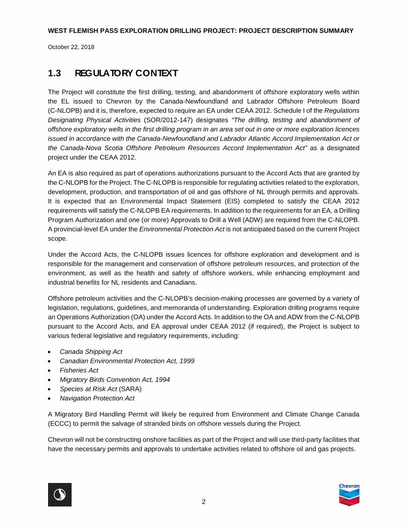
The Project is located in the Flemish Pass area, approximately 375 km northeast of St. John’s, NL, Canada area. The Project Area has been proposed that encompasses the EL and incorporates an approximate 20 km buffer. The EIS would define study area boundaries that will extend beyond the Project Area based on potential environmental interactions with routine and unplanned Project activities and in recognition of potential cumulative environmental effects. Project Area coordinates are provided in Table 1; the Project Area is shown on Figure 1.
Table 1 Project Area Coordinates
Label X_UTM
NAD 83, Zone 22 Y_UTM
NAD 83, Zone 22 X_deg Y_deg A 805009.6153 5390072 46° 51' 48.156" W N48° 35' 21.655"
B 809057.4088 5312548 46° 51' 54.621" W N47° 53' 30.259"
C 733017.1165 5309106 47° 52' 57.174" W N47° 53' 34.585"
D 730288.8723 5373550 47° 53' 2.643" W N48° 28' 22.328"
E 739197.9915 5381353 47° 45' 33.296" W N48° 32' 22.667"
F 753957.5124 5382022 47° 33' 33.256" W N48° 32' 23.437"
G 753699.4323 5387538 47° 33' 33.716" W N48° 35' 22.141"
2.2 PROJECT COMPONENTS AND ACTIVITIES
The Project may include drilling up to eight wells using either a semi-submersible rig or a drillship (Figure 2), referred to generically as a MODU. A drillship is typically used in relatively deep waters (either on anchor or using dynamic positioning (DP) systems at greater depths) or in areas where increased mobility is required due to ice or other factors and operational risks. A drillship would either be moored in position over the drilling site or, as is more likely for this drilling program, maintained on station by DP. A semi-submersible rig is typically used at moderate depths, such as on the Grand Banks, and anchored in place. Rig intake activities will include a rigorous inspection and certification before an OA will be issued by the C-NLOPB.
WEST FLEMISH PASS EXPLORATION DRILLING PROJECT: PROJECT DESCRIPTION SUMMARY
October 22, 2018
4
Figure 1 Project Area

WEST FLEMISH PASS EXPLORATION DRILLING PROJECT: PROJECT DESCRIPTION SUMMARY
October 22, 2018
5
Figure 2 Illustration of Drill Ship (front) and Semi-submersible (back)
Wellbore construction will typically begin with the spud of the well into the seabed and running and setting conductor and surface casing followed by cementing. During this process, drilling is typically done with a water-based mud system (WBM), where drill cuttings, drilling mud, and cement returns from casing cementing will be circulated to the seabed surrounding the wellhead. More information on the management of drilling waste is provided in Section 2.3.3. An unplanned or planned side-track (i.e., drilling perpendicular from an original wellbore) may be drilled to meet the Project objectives.
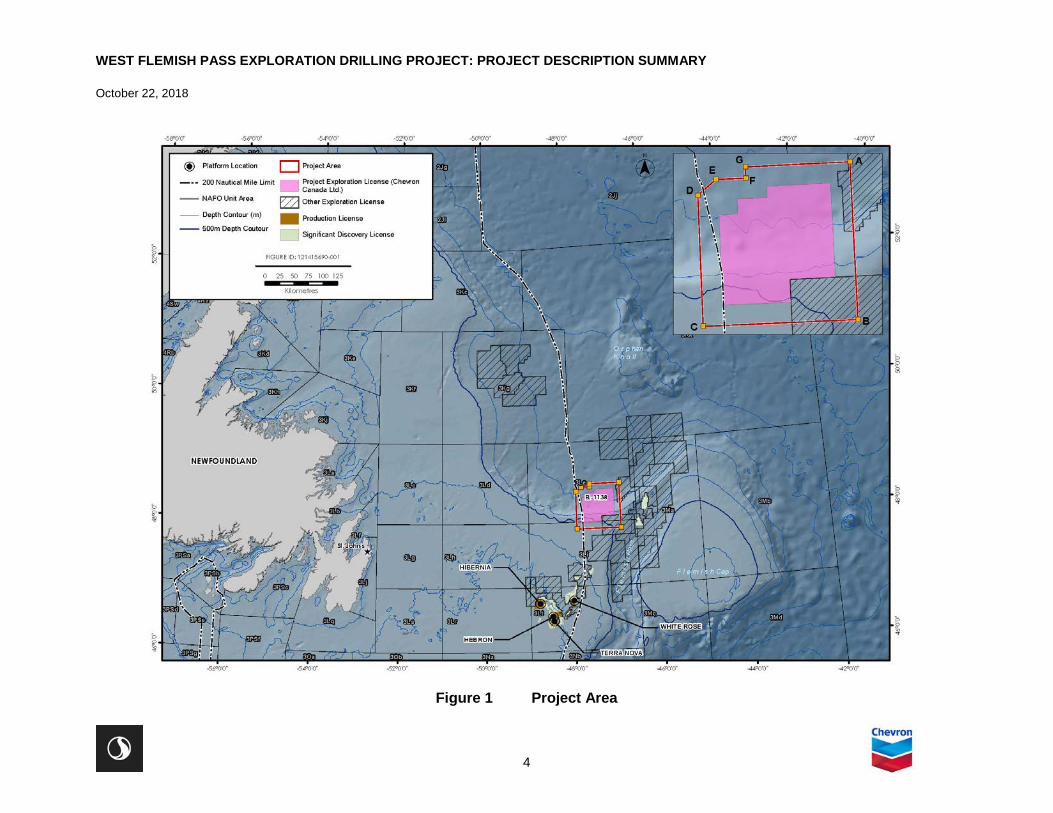
The blow out preventer (BOP), a piece of safety equipment that prevents hydrocarbons from escaping the wellbore into the environment, will then be run on the marine riser, landed and latched onto the wellhead, with the riser being connected to the drilling rig (Figure 3).
WEST FLEMISH PASS EXPLORATION DRILLING PROJECT: PROJECT DESCRIPTION SUMMARY
October 22, 2018
6
Source: Chevron 2018 Note: For illustration purposes only and not to scale. Additional casing strings may be necessary depending on the approved well design
Figure 3 Schematic of a Floating Rig While Drilling in a Closed Loop Circulating System
The riser will serve as the main conduit for remaining drilling activities at depth. Drilling will then resume in a closed loop drilling mud circulation system. The mud is pumped down the drilling string where it is used to cool and lubricate the bit and to transport cuttings and formation gas back to the rig for geological evaluation. The mud is then processed on the drilling rig and then recirculated back into the well. Drilling parameters including mud volumes will be closely monitored.
Chevron proposes to commence drilling in Q2 2021, pending regulatory approval. Depending on the results of the initial well, up to eight wells may be drilled over the term of the EL. It is anticipated that it will take approximately 180 days to drill each well.

WEST FLEMISH PASS EXPLORATION DRILLING PROJECT: PROJECT DESCRIPTION SUMMARY
October 22, 2018
7
Since geohazard surveys are regulated by the C-NLOPB we are planning to submit an application for those activities to the C-NLOPB. Geohazard surveys and are a planning tool used by exploration engineers to understand the conditions at the seabed and locate potential unstable conditions and hazardous features that could compromise potential future activities or installations. A geohazard survey is typically conducted three to four months in advance of drilling to gather information that will be used to design the Project. As such, a geohazard survey is required to support site selection and engineering and is not inherently part of designated Project (i.e., drilling). Under the C-NLOPB’s regulatory requirements, a geohazard survey is required prior to issuance of an Approval to Drill a Well. The C-NLOPB requires an environmental assessment of each geohazard survey that is completed under their EA process. Chevron will submit a separate environmental assessment for its geohazard surveys as an explicit element required by the C-NLOPB authorization process.
Once a specific wellsite has been determined and prior to drilling, the wellsite location is surveyed, generally using an ROV to inspect the seabed for sensitive habitat (e.g., habitat-forming corals). This survey is distinct from the geohazard survey noted above and is included in the EA as part of the Project scope.
2.2.1 Vertical Seismic Profiling
Vertical seismic profiling (VSP) is conducted to obtain accurate “time to depth ties” following the drilling of each well to its target depth (where hydrocarbon reservoirs are predicted to be located). It allows the correlation of seismic data (which are recorded in time measurements) to well depth (recorded in metres (m)). VSP operations involve deploying an acoustic sound source from the drilling or support vessel, while receivers are positioned at different levels within the drilled hole to measure the travel time.
Typically, between three and six sound sources are used, with a volume of 150 to 250 cubic inches each, although there could be up to 12 sound sources in a larger array. These sound sources are generally positioned at 5 to 10 m water depth. VSP operations typically take approximately one to three days to complete for each well. Specific details of the VSP program will depend on the geological target and the objectives of the VSP operation.
2.2.2 Well Evaluation and Testing
Well evaluation and testing help to determine the viability of a prospect and commercial potential of the reservoir and is required if hydrocarbons are discovered during an exploration drilling program. Well flow testing involves flowing the well fluids through temporary test equipment located on the drilling vessel and requires flaring of gases or other hydrocarbons that come to surface for safe disposal.
There are typically three levels of well evaluation for hydrocarbons. The first occurs while drilling in real time where data are collected both from downhole electronic tools in the bottom hole assembly (BHA) and from mud logging data collected from the mud returns from the well. Formation data are transmitted to the surface from the downhole tools while drilling and a separate evaluation of drill cuttings samples and gas entrained in the drilling mud are evaluated for hydrocarbon show. Both datasets are presented in real time logs to be monitored and evaluated at the rig site and data transmitted via satellite system to shore base.

WEST FLEMISH PASS EXPLORATION DRILLING PROJECT: PROJECT DESCRIPTION SUMMARY
October 22, 2018
8
The second level of evaluation usually occurs upon favorable data observed while drilling and when the targeted formation(s) have been fully drilled. Additional logs and formation pressures may be run on dedicated tool runs either on drill pipe or wireline, which collect advanced datasets to evaluate a potential hydrocarbon reservoir.
The third level of evaluation to fully determine a reservoir’s potential for oil production is the well test. A well test involves the rigging up of temporary production facilities on the drilling rig to allow the well to flow in a steady state and controlled manner to surface to obtain a dynamic dataset. Samples of oil are collected to fulfill requirements of a significant discovery. The oil produced throughout this period is usually directed to a flare boom and burned (flared) with a safe and efficient burner system that limits emissions and the risk of spillage to the sea. The amount of time flaring in a well test operation will be kept to a minimum but will need to be of sufficient time to collect necessary datasets. It is anticipated that two rig-days of flaring will be sufficient for a well test. There are emerging downhole technologies that may have the potential to substitute the requirements of the surface well test.
A well test may not occur right after the drilling phase but may be scheduled at a later date depending on rig schedule, anticipated sea states, and weather conditions. In the event of a delayed well test, the well will be secured with required barriers in place and suspended prior to moving the drilling rig off location.
Well testing will be subject to Chevron’s well test assurance process, which is designed to promote safe and efficient well test operations.
2.2.3 Well Abandonment
Upon acceptable evaluation of the well for hydrocarbons and upon C-NLOPB approval, the well will be permanently abandoned. An abandonment program will be executed using a configuration of cement and permanent mechanical bridge plugs. As a minimum, the C-NLOPB drilling and production guidelines related to abandonment will be adhered to. If Chevron abandonment criteria is more stringent, Chevron standard operating procedures will prevail. Once the well is abandoned, the last stage in the process is to remove the wellhead from the seabed depending on regulatory requirements. If determined that the wellhead needs to be removed, the preferred method is the mechanical cutter that can cut the wellhead below the seabed and then retrieved to surface. If a mechanical cutter cannot be used, an explosive charge may be used to sever the wellhead from the sea bed.
2.2.4 Supply and Servicing
Supply vessels and helicopters are used to transport personnel, equipment, and materials to and from the MODU during an offshore drilling initiative according to work schedules and rotations, workforce numbers, distances, and other factors. Supply vessels typically make regular trips to the MODU throughout a drilling program, and a dedicated stand-by vessel will attend to the rig.
The wellsite will be located offshore in a remote location more than 300 km from the port of St. John’s, NL. As with all offshore projects in this region, logistics and service requirements for a drilling rig can be challenging especially during seasons of heavy weather, fog, sea ice and icebergs, and sea states. The primary land base for offshore operations will be St. John’s for supply vessels and helicopter support. In

WEST FLEMISH PASS EXPLORATION DRILLING PROJECT: PROJECT DESCRIPTION SUMMARY
October 22, 2018
9
the event of sea ice impeding entrance to the harbour, a secondary base at Bay Bulls harbour (approximately a 15-minute drive from St. John’s) will be used. If there are heavy ice conditions near the coast and both ports are not accessible, the ice-free harbour at Marystown in Fortune Bay can be used; however, it is several hours away. While the rig is on location, a dedicated stand-by vessel will be stationed near the rig for emergencies and for secondary storage of well tubulars and drilling mud if required. A second vessel will service the rig by transporting equipment and people (in the event helicopters cannot fly) to and from the rig. It is anticipated that two to three sailings per week will be required but more is possible if a rig crew change is required. Similar to the drilling rig, supply vessels will need certification and approval in order to work in NL waters.
Helicopter support will be from St. John’s and will be the primary method to transport personnel to and from the rig. If helicopters cannot fly because of poor visibility from fog or from high winds, consideration will be given to transport by vessel depending on the long-term weather forecast and the urgency to get people to the rig. Emergency response, safety procedures, and protocol will be in place for transport of personnel offshore.
2.3 EMISSIONS, DISCHARGES AND WASTE MANAGEMENT
2.3.1 Atmospheric Emissions
Atmospheric emissions expected to be associated with Project activities are primarily related to the combustion of marine fuel by the drilling vessel and Project supply vessels (PSVs). Emissions are also associated with short-term flaring during well testing, if testing is performed. These emissions will include carbon monoxide (CO), carbon dioxide (CO2), sulphur dioxide (SO2), nitrogen oxides (NOX), and particulate matter (PM). Chevron will comply with the provincial Air Pollution Control Regulations, Ambient Air Quality Objectives under the Canadian Environmental Protection Act, regulations under the International Convention for the Prevention of Pollution from Ships (MARPOL), and the intent of the Global Gas Flaring Reduction Partnership (which seeks to increase the use of associated natural gas and thus reduce flaring and venting).
With respect to greenhouse gas (GHG) emissions, it is estimated that there could be approximately 348 tonnes of CO2 equivalent (CO2e) emissions associated with operational drilling, vessel traffic, and helicopter traffic per day or approximately 62,566 tonnes CO2e over the drilling program, assuming a 180-day drilling program. These emissions represent 0.58% of the total reported provincial GHG emissions for 2016 (10,790,000 tonnes CO2e) and 0.009% of the 2016 national emissions (704,000,000 tonnes CO2e) (ECCC 2018). Assuming that there could be between zero to three wells drilled per year over the term of the EL, annual GHG emissions resulting from the Project are estimated to be up to approximately 187,698 tonnes CO2e.
Artificial light emissions associated with the Project include navigation and deck lighting from the MODU and PSVs. Artificial lighting will be reduced to the extent that it does not affect worker and vessel safety. In the event of flaring during well testing, there will be temporary (e.g., up to two or three days) light and thermal emissions associated with the flare. Atmospheric sound will be generated by the MODU, PSVs, and helicopter traffic. However, there is limited predicted interaction with human receptors given the

WEST FLEMISH PASS EXPLORATION DRILLING PROJECT: PROJECT DESCRIPTION SUMMARY
October 22, 2018
10
distance of the MODU offshore and that the PSVs and helicopter will operate out of existing port and airport facilities. The sound generated by Project traffic will be comparable to existing vessel and helicopter traffic.
2.3.2 Underwater Sound
Underwater sound is generated by the MODU and supply vessels, as well as during VSP operations. The level of underwater sound generated is influenced by the type of drilling vessel (e.g., semi-submersible versus drillship) and method of positioning on station (e.g., use of thrusters for DP versus anchoring). The propagation of underwater sound with distance from a source is influenced by water column and seabed characteristics. Underwater sound associated with the MODU is continuous during a drilling program. Underwater sound generated during VSP operations is impulsive, with higher sound level pulses occurring over of a much shorter duration (up to approximately three days, depending on the VSP method selected).
2.3.3 Drilling Waste
Drilling muds are fluids which lubricate and cool the drill bit and hole, circulate cuttings and carry them back to the surface, and help to maintain appropriate hydrostatic pressure in the well to overbalance formation pressure, providing the primary barrier for well control (BOP forms part of the secondary barrier). Several types of drilling muds will be used, WBMs primarily being used for the riserless sections of a well. Synthetic-based drilling muds (SBMs) are generally used once the riser has been installed, and WBMs can also be used in certain applications. The primary component of WBMs is seawater, with other additives including bentonite (clay), barite, and potassium chloride. Other approved chemicals are also added as required to achieve and control the required mud properties.
The initial (i.e., surface) sections are normally drilled riserless with WBM, with mud and cuttings returned to the seabed where they will accumulate near the wellhead. The discharge of WBM cuttings at the seabed, while drilling the first two-hole sections, is accepted as industry standard practice and is consistent with the Offshore Waste Treatment Guidelines (OWTG). Spent and excess WBM may be discharged from the drilling vessel without treatment as per the OWTG. The deeper (lower hole) sections of the wells will likely be drilled with SBM. The marine riser located between the BOP and the drilling vessel acts as a conduit for the return of drilling mud and cuttings back to the drilling vessel for treatment prior to disposal of cuttings to the seabed in accordance with the OWTG.
On the drilling vessel, the drilled cuttings and drilling mud are separated and cleaned using solids control equipment. The mud returns carrying the drilled cuttings initially pass through a shale shaker, where most of the mud is separated from the cuttings. Where SBM is used, cuttings from the shale shaker pass through a cuttings dryer, which removes SBM from cuttings. Residual synthetics-on-cuttings discharged to the marine environment is treated in accordance with the OWTG prior to discharge. Monitoring of the residual base mud-on-cuttings levels is carried out during well sections involving use of SBM. After recovery and treatment of drill muds, the drill cuttings are discharged from the drilling vessel at the well site. No surplus SBM is discharged to the sea; spent SBM that cannot be reused during drilling is brought to shore for disposal in an approved licensed facility.
Drilling cement is pumped into the casing / wellbore annuli after the casing is installed. Prior to installation of the marine riser and BOP, excess cement is discharged on the seabed surrounding the wellhead.

WEST FLEMISH PASS EXPLORATION DRILLING PROJECT: PROJECT DESCRIPTION SUMMARY
October 22, 2018
11
Cement returned to the drilling unit will be transported back to shore and disposed of at an appropriate facility. During commissioning and testing of a cement unit, small volumes of cement may be discharged into the sea.
2.3.4 Liquid Discharges
Liquid wastes generated from the MODU and/or the supply vessels may include:
• Produced water • Bilge and deck drainage water • Ballast water • Grey / black water (sewage) • Cooling water • Well treatment fluids • Fire control testing water • BOP fluid
The OWTG specifies allowable chemical properties for offshore disposal to the marine environment and associated reporting requirements, including in some cases, required sampling and analysis prior to ocean discharge. Where discharges occur offshore, the points of discharge will be below the water surface. Liquid discharges that do not meet OWTG performance targets for ocean disposal are transported back to shore for disposal at an approved licensed disposal facility.
2.3.5 Hazardous and Non-Hazardous Solid Wastes
Hazardous and non-hazardous solid wastes will also be generated by Project activities. Non-hazardous wastes may include domestic waste, scrap metal, recyclables, and other miscellaneous non-hazardous wastes. Hazardous wastes (including waste dangerous goods) could include oily waste (filters, rags, waste oil), waste chemicals and containers, batteries, and biomedical waste. Food wastes and domestic sewage will be macerated in accordance with the OWTG and MARPOL prior to discharge at sea (below the water surface). Other solid waste generated offshore will be transported to shore for appropriate treatment and/or disposal in accordance with applicable regulations and municipal by-laws.
Chevron will retain a third-party licensed waste management contractor to manage and dispose of wastes transported onshore. Hazardous wastes will be stored in dedicated and appropriate waste receptacles and then disposed of at approved facilities in compliance with applicable regulations and approvals.
2.4 PROJECT SCHEDULE
Chevron proposes to commence exploration drilling with an initial well in 2021 pending regulatory approval to proceed. Up to eight exploration wells could be drilled over the term of the EL (2021 to 2030) contingent on the drilling results of the initial well. Drilling activities will not be continuous and will be in part determined by rig availability and previous wells’ results. It is anticipated that each well will take approximately 180 days to drill.

WEST FLEMISH PASS EXPLORATION DRILLING PROJECT: PROJECT DESCRIPTION SUMMARY
October 22, 2018
12
Chevron’s preference is to conduct drilling between May and September, although the EIS (if required under CEAA 2012) will assume year-round drilling. VSP operations will take approximately one to three days per well and well testing, where required, would occur over a one to three-month period. Well abandonment will likely be conducted following drilling and/or well flow testing. Wells may be designed for suspension and re-entry but this will be determined through further prospect evaluation.
2.5 POTENTIAL ACCIDENTAL EVENTS
Chevron has an integrated Corporate Operational Excellence (OE) Risk Management process that has been designed to identify and address the health, environment, safety, and asset risks to facilities and activities. The process is designed to prevent high-consequence incidents and impacts by systematically assessing risk across OE focus areas, identifying the safeguards that need to be in place, and ensuring that those safeguards function as intended.
Multiple preventative and response barriers are put in place to manage risk, both in terms of the incident arising in the first place, and to mitigate and respond to incidents to manage potential consequences. Potential accidental events that could occur during exploration drilling and potentially result in a release to the environment, include vessel collision, dropped objects, loss of well control (e.g., blowout), and spills and releases from MODU or supply vessels.
Chevron will conduct predictive spill modelling to help assess the risk of adverse environmental effects that might occur as a result of potential accidental events associated with the Project. The EIS (if required under CEAA 2012) will also provide an overview of Chevron’s overall oil spill preparedness and response capability which will include a range of specific response measures such as offshore containment and recovery, chemical dispersant use, in situ burning, shoreline protection, and oiled wildlife response.
3.0 ENVIRONMENTAL SETTING
3.1 PHYSICAL ENVIRONMENT
The geology of the eastern Newfoundland offshore area is complex and dynamic, as the current bedrock and surficial characteristics of the area have been shaped by various natural and human factors and processes over time (AMEC 2014). The main sedimentary basins in the area include the Orphan, Flemish Pass, Jeanne d’Arc, and Carson basins (Fader et al. 1989). The primary reservoirs are located in the shallow marine and fluvial sandstones deposited during the Late Jurassic and Early Cretaceous periods of the Mesozoic Era. The Late Jurassic Egret member of the Rankin Formation is a world-class source rock that is recognized as the primary source of the oil and gas discovered in the Jeanne d’Arc Basin, which is the only basin off eastern Newfoundland containing presently developed producing oil fields. This rock type has also proven to be widespread in the Flemish Pass Basin (G and G Exploration Consulting Ltd. 2003).
The Project Area experiences weather conditions typical of a marine climate, including reduced visibilities, low cloud heights, and large amounts of precipitation (LGL 2011a). Prevailing winds are from the west to northwest in winter and from the south and west in summer with extreme wind gusts greater than 100 knots

WEST FLEMISH PASS EXPLORATION DRILLING PROJECT: PROJECT DESCRIPTION SUMMARY
October 22, 2018
13
(51 m/s) (AMEC 2014). The surrounding waters have a moderating effect on temperature and air temperatures are coolest in February and warmest in July. In the Flemish Cap area and surrounding region, most precipitation events are in the form of rain or, in the winter, snow, while other precipitation types, such as mixed rain and snow, freezing rain, and hail, occur far less frequently. Rain occurs most frequently in October and November while snowfall is at its peak in January and February. Freezing rain and drizzle are relatively infrequent, occurring <1% of the time in any given month. There is a year-round potential for thunderstorms and hail, with the highest frequency of occurrence in July (AMEC 2014).
Circulation in the Project Area off the coast of NL is dominated the Labrador Current and the North Atlantic Current (Colbourne and Foote 2000, in LGL 2011a). The main current in the Project Area is the Labrador Current, which consists of two streams: an inshore branch which transports sub-polar water to lower latitudes along the Continental Shelf of Eastern Canada; and an offshore branch that flows along the outer edge of the Grand Banks. Sea surface temperatures generally average about 3.4°C in February to 12.8°C to 16°C in the August / September period (AMEC 2014). Within the Project Area, and in surrounding areas, the largest seas are typically found farthest offshore, usually during the winter season between December and January.
Air quality within the Project Area, and in surrounding areas, is good, with occasional exposure to exhaust products from supply vessels, other marine traffic, helicopters, and existing offshore oil production facilities in the Jeanne d’Arc Basin (Hibernia, Terra Nova, White Rose, and Hebron). The area also receives long-range contaminants from the Northeast Seaboard and industrial mid-west of the United States (ExxonMobil Canada Properties 2011, in Husky Energy 2012).
3.2 BIOLOGICAL ENVIRONMENT
The eastern Newfoundland offshore area is a highly-productive ecosystem and there are many species of fish, marine mammals, sea turtles, and marine birds that occur, or could potentially occur, in the Project Area. Some of these species are listed as species at risk under SARA and/or are identified as species of conservation interest by the Committee on the Status of Endangered Wildlife in Canada (COSEWIC).
A variety of fish species and assemblages occur with “shallow water” groups (e.g., yellowtail flounder, Atlantic cod, redfish, and skates) giving way to “slope” assemblages (e.g., Greenland halibut, roughhead grenadier, wolffish) and finally to “deep slope-abyssal assemblages” (e.g., lanternfish, grenadiers, blue hake, dogfish). Within such depth zones, habitat complexity can also be a determining factor of species presence and prevalence.
The highest diversity of benthic species on the Flemish Cap was observed between 500 and 1,000 m depths, with corals and sponges as the most dominant trawl captured taxa, followed by echinoderms, arthropods, and molluscs (Vàsquez et al. 2013; Murillo et al. 2016). Sponges and cnidarians represented the highest number of taxa, followed by arthropods, echinoderms, and molluscs. The Flemish Cap has a relatively higher coral richness than other parts of the Project Area and surrounding marine environments, likely because of the diversity of habitat types and depth gradients in comparison to other areas (Murillo et al. 2011, 2016).

WEST FLEMISH PASS EXPLORATION DRILLING PROJECT: PROJECT DESCRIPTION SUMMARY
October 22, 2018
14
The waters off eastern Newfoundland support a diverse assemblage of marine fauna that includes some 20 marine mammals and several sea turtle species, many of which are considered to be at risk or otherwise of special conservation concern. Marine mammal (cetacean) species that are known or considered likely to occur within eastern Newfoundland include mysticetes (baleen whales), odontocetes (toothed whales and porpoises), and pinnipeds (seals).
A variety of seabirds and other marine-associated birds, including gannets, phalaropes, large gulls, kittiwakes, terns, alcids (auks), jaegers and skuas, fulmars, petrels, and shearwaters occur within the Project Area and in adjacent marine and coastal regions. Important habitats for breeding, feeding, migration, and other seabird activities have been identified at locations along the coastline of eastern Newfoundland, within and well outside of the proposed Project Area (AMEC 2014). Waterfowl occur in large numbers in marine habitats off eastern Newfoundland, especially during the winter months, but they prefer open water in coastal areas and are thus not likely to frequent the offshore environments that characterize the Project Area (AMEC 2014). The region also contains several designated Important Bird Areas (IBAs), which provide important habitat for nationally and/or globally important numbers of birds and/or avian species at risk, and there are various other sites of provincial and regional significance to birds. Although none of these areas or sites occurs within the Project Area itself, some of the bird species that make use of these designated habitats may spend time in the Project Area.
A number of land-based, marine, and coastal areas within and off eastern Newfoundland have been designated as protected under provincial, federal, and/or other legislation and processes, or have been formally identified through relevant forums and processes as being otherwise special or sensitive due to their ecological, historical, and/or socio-cultural characteristics and importance (Table 2). Given its location nearly 400 km offshore, the Project will not occur within, or otherwise interact directly with, the existing provincial or federal Parks, Ecological Reserves, Wildlife Reserves, Marine Protected Areas (MPAs), Migratory Birds Sanctuaries, IBAs, or other locations that have been designated as protected on or around the Island of Newfoundland (AMEC 2014). However, the Project Area does overlap with two Ecologically and Biologically Significant Areas (EBSAs) off eastern Newfoundland: Northeast Shelf and Slope; and Slopes of the Flemish Cap and Grand Bank (Figure 4).
Currently, there are no MPAs established within the vicinity of the Project Area. However, in December 2017, the Minister of Fisheries and Oceans and the Canadian Coast Guard announced the establishment of several marine refuges off the coasts of Nunavut and NL. The Northeast Newfoundland Slope Closure is a marine refuge that overlaps with the Project Area (Figure 4). It has been established to contribute to long-term conservation of biodiversity by protecting corals and sponges from bottom contact fishing gear (Government of Canada 2017).
Outside of Canada’s 200 nm Exclusive Economic Zone (EEZ), Northwest Atlantic Fisheries Organization (NAFO) has identified vulnerable marine ecosystems that are regulated through their Conservation and Enforcement Measures, created to monitor and regulate bottom fishing activities by the member states of NAFO. These conservation and enforcement measures, such as carrying scientific observers on board to report encounters with vulnerable marine ecosystems indicator species, are specific for bottom fishing activities and does not include oil and gas activities (NAFO 2016).

WEST FLEMISH PASS EXPLORATION DRILLING PROJECT: PROJECT DESCRIPTION SUMMARY
October 22, 2018
15
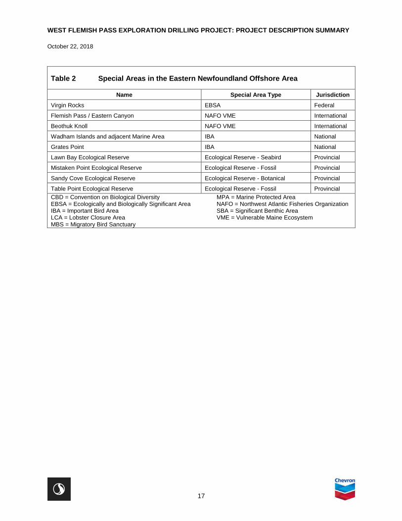
Table 2 Special Areas in the Eastern Newfoundland Offshore Area
Name Special Area Type Jurisdiction Hamilton Inlet EBSA Federal
Labrador Marginal Trough EBSA Federal
Labrador Slope EBSA Federal
Hawke Channel Closure Area National
Gilbert Bay MPA Gilbert Bay EBSA Federal
St. Peter Bay IBA National
Small Gorgonian Significant Benthic Areas SBA Federal
Seabird Foraging Zone in the Southern Labrador Sea CBD EBSA Northeast Newfoundland Slope-Tobin's Point 1 Closure Area National
Orphan Spur EBSA Federal
Orphan Knoll CBD EBSA Orphan Knoll NAFO VME International
Point Amour, Strait of Belle Isle IBA National
Watts Point Ecological Reserve Ecological Reserve - Botanical Provincial
Burnt Cape Ecological Reserve Ecological Reserve - Botanical Provincial
Grey Islands EBSA Federal
Hare Bay Islands Ecological Reserve Ecological Reserve - Seabird Provincial
Fischot Islands IBA National
Northern Groais Island IBA National
Bell Island South Coast IBA National
Ile aux Canes and Shepherd Island MBS Funk Island Deep Closure Area National
Notre Dame Channel EBSA Federal
Sea Pen Significant Benthic Areas SBA Federal
Mouse Island LCA Glover's Harbour LCA Fogo Shelf EBSA Federal
Gander Bay LCA Funk Island IBA National
Funk Island Ecological Reserve Ecological Reserve - Seabird Provincial
Tobin's Point 2 Closure Area National
Bonivista Cod Box Voluntary Fisheries Closures Area -
Slopes of the Flemish Cap and Grand Bank CBD EBSA Cape Freels Coastline and Cabot Island IBA National

WEST FLEMISH PASS EXPLORATION DRILLING PROJECT: PROJECT DESCRIPTION SUMMARY
October 22, 2018
16
Table 2 Special Areas in the Eastern Newfoundland Offshore Area
Name Special Area Type Jurisdiction West Brook Ecological Reserve Ecological Reserve - Botanical Provincial
Eastport MPA Terra Nova MBS Terra Nova National Park IBA National
Sackville Spur NAFO VME International
Northern Flemish Cap NAFO VME International
Northeast Flemish Cap NAFO VME International
Smith Sound EBSA Federal
Gooseberry Island LCA Baccalieu Island IBA National
Baccalieu Island Ecological Reserve Ecological Reserve - Seabird Provincial
Northeast Shelf and Slope EBSA Federal
Northwest Flemish Cap NAFO VME International
Eastern Flemish Cap NAFO VME International
Burgeo Bank EBSA Federal
Penguin Island LCA Green Island IBA National
Fortune Head Ecological Reserve Ecological Reserve - Fossil Provincial
Middle Lawn Island IBA National
Corbin Island IBA National
Placentia Bay Extension EBSA Federal
Placentia Bay IBA National
Cape St. Mary's IBA National
Cape St. Mary's Ecological Reserve Ecological Reserve - Seabird Provincial
Hawke Hill Ecological Reserve Ecological Reserve - Botanical Provincial
Cape St. Francis IBA National
Quidi Vidi Lake IBA National
Eastern Avalon EBSA Federal
Witless Bay Islands IBA National
Witless Bay Ecological Reserve Ecological Reserve - Seabird Provincial
The Cape Pine and St. Shotts Barren IBA National
Mistaken Point IBA National
St. Pierre Bank EBSA Federal
Laurentian Channel and Slope EBSA Federal
Large Gorgonian Significant Benthic Areas SBA Federal
WEST FLEMISH PASS EXPLORATION DRILLING PROJECT: PROJECT DESCRIPTION SUMMARY
October 22, 2018
17
Table 2 Special Areas in the Eastern Newfoundland Offshore Area
Name Special Area Type Jurisdiction Virgin Rocks EBSA Federal
Flemish Pass / Eastern Canyon NAFO VME International
Beothuk Knoll NAFO VME International
Wadham Islands and adjacent Marine Area IBA National
Grates Point IBA National
Lawn Bay Ecological Reserve Ecological Reserve - Seabird Provincial
Mistaken Point Ecological Reserve Ecological Reserve - Fossil Provincial
Sandy Cove Ecological Reserve Ecological Reserve - Botanical Provincial
Table Point Ecological Reserve Ecological Reserve - Fossil Provincial CBD = Convention on Biological Diversity MPA = Marine Protected Area EBSA = Ecologically and Biologically Significant Area NAFO = Northwest Atlantic Fisheries Organization IBA = Important Bird Area SBA = Significant Benthic Area LCA = Lobster Closure Area VME = Vulnerable Maine Ecosystem MBS = Migratory Bird Sanctuary

WEST FLEMISH PASS EXPLORATION DRILLING PROJECT: PROJECT DESCRIPTION SUMMARY
October 22, 2018
18
Figure 4 Special Areas
WEST FLEMISH PASS EXPLORATION DRILLING PROJECT: PROJECT DESCRIPTION SUMMARY
October 22, 2018
19
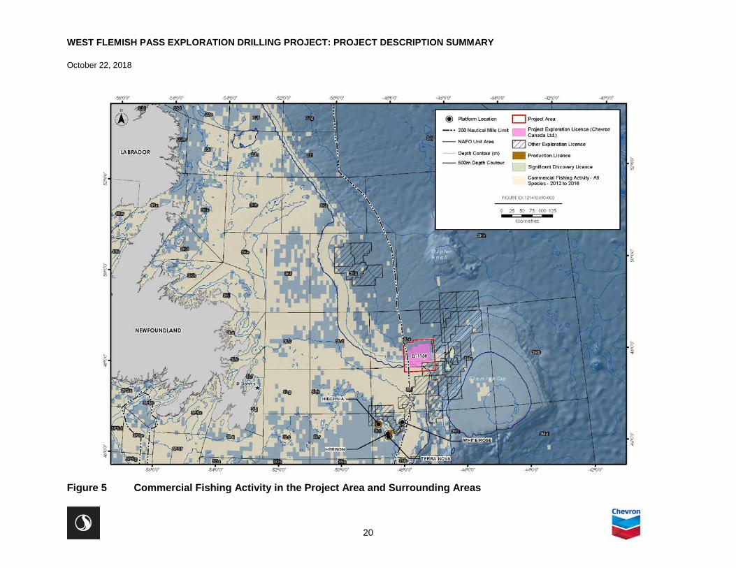
3.3 HUMAN ENVIRONMENT
Fisheries are an important component of the socio-economic environment of NL and other parts of Canada, including the various communities and regions that extend along the coastline of eastern Newfoundland who participate in commercial fishing as a source of economic stimulus to the local economy. Commercial fisheries in this region are diverse, and involve a range of target species, use of various gear types, and occur at higher intensities at certain times of the year. The Project Area is in a region (Flemish Pass) where multiple fishers harvest for commercial purposes. EL 1138 is located within NAFO Subdivision 3L, where commercial fishing activity has historically been high in certain areas (Figure 5).
A portion of EL 1138 overlaps a small portion where commercial fishing activity has historically occurred. Species that have been historically harvested for commercial purposes in eastern offshore NL include snow crab, northern shrimp, Greenland halibut, Atlantic halibut, Atlantic cod, American plaice, redfish, and flounder (yellowtail and witch). Fisheries for pelagic species such as capelin and mackerel do occur in offshore NL but are located closer to the coast and nearshore areas. Commercial fisheries for large pelagic species such as swordfish and tuna, and for invertebrates such as clams and scallops also occur, but on a smaller scale than those for crab, shrimp, and groundfish.
Innu Nation, Nunatsiavut Government, NunatuKavut Community Council, Miawpukek First Nation, Qalipu Mi’kmaq First Nation Band, and Mi'kmaq Alsumk Mowimsikik Koqoey Association have communal commercial fishing licences issued under the Aboriginal Communal Fishing Licences Regulations. There are no food, social, and ceremonial (FSC) fisheries in the Project Area, or in surrounding areas. The closest FSC fishery in NL is a multi-species coastal fishery undertaken by Miawpukek First Nation in Conne River, over 500 km to the southwest of the Project Area (Nexen Energy ULC 2017).
NL has five Indigenous communities and/or governing bodies; three in Labrador (Nunatsiavut Government, Innu Nation, and Nunatukavut Community Council) and two on the Island of Newfoundland (Miawpukek First Nation; Qalipu Mi’kmaq First Nation). EL 1138 is approximately 590 km to the nearest reserve (Miawpukek).
Other human activities also take place in parts of the Project Area and surrounding marine environment on either a year-round or seasonal basis. Offshore oil and gas production has been occurring off the coast of NL for approximately 20 years, and exploration in the region has occurred for a much longer period. Various international oil and gas operators have held, and currently hold, interests in the NL offshore area.
International shipping lanes transit through the eastern Newfoundland offshore area, and there is potential for vessel traffic in the Project Area and in surrounding areas. The eastern region of Newfoundland has approximately 17 ports that are used for both domestic and international shipping activities. Marine research and scientific studies regularly occur in the Project Area, and in surrounding areas. DFO activities include annual multi-species trawl surveys to monitor fish populations, collection of data from buoys and moorings for DFO’s Rapid Climate Change program study, and the Atlantic Zone Off-Shelf Monitoring Program.
WEST FLEMISH PASS EXPLORATION DRILLING PROJECT: PROJECT DESCRIPTION SUMMARY
October 22, 2018
20
Figure 5 Commercial Fishing Activity in the Project Area and Surrounding Areas

WEST FLEMISH PASS EXPLORATION DRILLING PROJECT: PROJECT DESCRIPTION SUMMARY
October 22, 2018
21
Naval training exercises also occur in the general area, which involve both surface vessels and submarines. There are also known and potential unexploded ordnance sites in the Atlantic Ocean, which include shipwrecks and submarines, as well as munitions dump sites off eastern Newfoundland (AMEC 2014). Marine cable networks (active and decommissioned) also cross through the region.
3.4 EXISTING ENVIRONMENTAL STUDIES
Environmental assessments have been completed for various exploration drilling, production drilling, and seismic survey projects for nearly three decades in the Canada-Newfoundland and Labrador Offshore Area. These assessments are important sources of information on the region’s existing environmental setting, as well as the potential environmental issues and interactions that may be associated with Project activities. The primary studies that are cited in this Project Description to describe the existing environmental setting in the Project Area and surrounding areas, include project-specific EAs conducted for other projects with similar spatial boundaries. Of particular relevance is the Strategic Environmental Assessment (SEA) for the eastern NL offshore region (AMEC 2014).
Other key relevant environmental studies for consideration include:
• Nexen Energy ULC’s Flemish Pass Exploration Drilling Project (2018-2028) (Nexen Energy ULC 2018) • Equinor Canada Ltd. (Statoil Canada Ltd.) Flemish Pass Exploration Drilling Project 2018-2028
(Equinor Canada 2017) • ExxonMobil Canada Limited Eastern Newfoundland Offshore Exploration Drilling Project 2018-2030
(ExxonMobil Canada Limited 2017) • Husky Energy Exploration Drilling Project 2018-2025 (Husky Energy 2018) • BP Canada Energy Group ULC Newfoundland Orphan Basin Exploration Drilling Program, 2017-2026
(BP Canada Energy Group ULC 2018) • Eastern Newfoundland SEA (AMEC 2014) • Environmental Assessment East Canada CSEM Survey, 2014-2018 (LGL Limited 2014) • Suncor Energy’s Eastern Newfoundland Offshore Area 2D / 3D / 4D Seismic Program, 2014-2024
(Suncor Energy 2013) • White Rose Extension Project Environmental Assessment (Husky 2012) • Hebron Project Comprehensive Study Report (ExxonMobil Canada Properties 2011) • Environmental Assessment of Chevron’s North Grand Banks Regional Seismic Program, 2011-2017
(LGL 2011a) • Environmental Assessment of Statoil’s Geophysical Program for Jeanne d’Arc Basin and Central Ridge
/ Flemish Pass Basins, 2011-2019. (LGL 2011b). • Environmental Assessment of Husky’s Jeanne d’Arc Basin / Flemish Pass Regional Seismic Program,
2012-2020 (LGL 2011c) • Environmental Assessment of StatoilHydro Canada Ltd. Exploration and Appraisal/Delineation Drilling
Program for Offshore Newfoundland, 2008-2016 (LGL 2008) • Husky Delineation/Exploration Program for Jeanne d’Arc Basin Area, 2008-2017, Environmental
Assessment (LGL 2007) • Husky White Rose Development Project: New Drill Centre Construction and Operations Program
Environmental Assessment (LGL 2006) • Orphan Basin SEA (LGL 2003a) • Orphan Basin Exploration Drilling Program Environmental Assessment (LGL 2005) • White Rose Oilfield Comprehensive Study (Husky Oil 2000)

WEST FLEMISH PASS EXPLORATION DRILLING PROJECT: PROJECT DESCRIPTION SUMMARY
October 22, 2018
22
4.0 CONSULTATION AND ENGAGEMENT
4.1 INDIGENOUS ENGAGEMENT
Chevron recognizes the importance of early and ongoing Indigenous and stakeholder engagement that continues over the life of the Project. Chevron believes that it is important to operate in NL by building relationships with Indigenous groups and key stakeholders. Chevron is committed to collaborating with Indigenous peoples of Canada and communities to build long-term trusting and mutually beneficial relationships based on the principles of inclusion, transparency, respect, and accountability. As mentioned in Section 3.3, the Indigenous organizations in eastern NL that hold commercial communal fishing licences for NAFO Divisions that overlap the Project Area are:
• Labrador Inuit (Nunatsiavut Government) • Labrador Innu (Innu Nation) • NunatuKavut Community Council • Qalipu Mi’kmaq First Nation Band • Miawpukek Mi'kmamawey Mawi'omi (Miawpukek First Nation)
Ongoing engagement will include confirmation of appropriate organization and/or community contacts and methods for future engagement, learning more about how these groups may potentially be affected by Project activities, providing Project planning updates, and listening and responding to questions and concerns raised by Indigenous groups in a timely manner. Feedback obtained during engagement will be incorporated into Project planning as applicable and appropriate. The EIS (if required under CEAA 2012) will document concerns and priorities raised and demonstrate how these have influenced Project planning and/or been addressed in the EIS. Indigenous groups in New Brunswick, Nova Scotia, Prince Edward Island, and Quebec will be engaged in the EIS preparation process:
• New Brunswick − Elsipogtog First Nation − Mi’gmawe’l Tplu’taqnn Inc. (MTI), which represents the following Mi’kmaq First Nation groups
o Tjipõgtõtjg (Buctouche) First Nation o Natoaganeg (Eel Ground) First Nation o Ugpi’ganjig (Eel River Bar) First Nation o Esgenoôpetitj (Burnt Church) First Nation o Amlamgog (Fort Folly) First Nation o L’nui Menikuk (Indian Island) First Nation o Metepenagiag Mi’kmaq Nation o Oinpegitjoig (Pabineau) First Nation
− Wolastoqey Nation of New Brunswick (WNNB), which coordinates consultation with the following five Maliseet First Nations o Kingsclear First Nation o Madawaska Maliseet First Nation o Oromocto First Nation o Saint Mary’s First Nation o Tobique First Nation

WEST FLEMISH PASS EXPLORATION DRILLING PROJECT: PROJECT DESCRIPTION SUMMARY
October 22, 2018
23
− Woodstock First Nation − Peskotomuhkati Nation at Skutik (Passamaquoddy)
• Nova Scotia − Kwilmu’kw Maw-klusuaqn Negotation Office (KMKNO), which represents the following 11 Mi’kmaq
First Nations in Nova Scotia in consultation and engagement o Acadia First Nation o Annapolis Valley First Nation o Bear River First Nation o Eskasoni First Nation o Glooscap First Nation o Membertou First Nation o Potlotek First Nation o Paq’tnkek First Nation o Pictou Landing First Nation o Wagmatcook First Nation o We’koqmaq First Nation
− Sipekne'katik First Nation − Millbrook First Nation
• Prince Edward Island − Mi’kmaq Confederacy of PEI (MCPEI), which represents the following Mi’kmaq First Nations in
consultation o Abegweit First Nation o Lennox Island First Nation
• Quebec − Conseil des Montagnais de Natashquan − Conseil des Innus de Ekuanitshit − Mi’gmawei Mawiomi Secretariat (MMS), which represents the following Mi’gmaq First Nation
groups: o La Nation Micmac de Gespeg o Listuguj Mi'gmaq Government o Micmacs of Gesgapegiag
4.2 STAKEHOLDER ENGAGEMENT
4.2.1 Government and Regulatory Stakeholders
As of October 19, 2018, Chevron has engaged with a number of regulatory stakeholders to confirm specific regulatory requirements / processes and/or data requests, including:
• C-NLOPB • Government of Canada
− CEA Agency − DFO − ECCC − Canadian Coast Guard − Natural Resources Canada (NRCan) − Department of National Defence (DND) − Transport Canada

WEST FLEMISH PASS EXPLORATION DRILLING PROJECT: PROJECT DESCRIPTION SUMMARY
October 22, 2018
24
• Government of NL − Municipal Affairs and Environment − Fisheries and Land Resources − Natural Resources
• Fisheries − One Ocean − Fish, Food and Allied Workers-Unifor (FFAW-Unifor) − Association of Seafood Producers (ASP) − Ocean Choice International (OCI) − Groundfish Enterprise Allocation Council (GEAC) − Canadian Association of Prawn Producers (CAPP-Prawn)
A summary of stakeholder engagement to date is in Table 3.
Chevron will continue to engage these organizations and other government departments and agencies, industry associations, and Non-Governmental Organizations during the EA process and subsequent regulatory approvals for the Project.

WEST FLEMISH PASS EXPLORATION DRILLING PROJECT: PROJECT DESCRIPTION SUMMARY
October 22, 2018
25
Table 3 Summary of Engagement to Date (as of October 19, 2018)
Organization Date Type of Engagement
Purpose Comments / Concerns
CEA Agency August 24, 2018
Email Project introduction. Meeting request. Included map of lease area of interest.
Email response August 27th, 2018. Meeting set for September 21st, 2018.
C-NLOPB August 24, 2018
Email Project introduction. Meeting request. Included map of lease area of interest.
Email response August 24th, 2018. Meeting set for September 18th, 2018.
DFO August 24, 2018
Email Project introduction. Meeting request. Included map of lease area of interest.
Email response August 24, 2018. Meeting set for September 20th, 2018.
ECCC August 24, 2018
Email Project introduction. Meeting request. Included map of lease area of interest.
Email response to Stantec on September 7, 2018. Meeting date set for September 18th, 2018.
Transport Canada September 25, 2018
Email Project introduction. Request for comments, concerns, or questions regarding the project. Included map of lease area of interest.
No response.
DND and the Canadian Armed Forces
September 25, 2018
Email Project introduction. Request for comments, concerns, or questions regarding the project. Included map of lease area of interest.
Email response September 26, 2018.
Health Canada August 31, 2018
Email Project introduction. Request for comments, concerns, or questions regarding the project. Included map of lease area of interest.
Email response on September 5, 2018 stating interest in EA review with focus on indigenous recreational / commercial fishing and accident / malfunctions potentially affecting harvesting.
NRCan August 31, 2018
Email Project introduction. Request for comments, concerns, or questions regarding the project. Included map of lease area of interest.
Email response on September 7, 2018. Indicated that NRCan will review the Project Description once it is submitted to CEAA and will provide expertise as part of the EA process. NRCan does not have any environmental guidance documents to provide at this time.
NL Department of Natural Resources
September 26, 2018
Email Project introduction. Request for comments, concerns, or questions regarding the project. Included map of lease area of interest.
Email response on September 27th, 2018 offering assistance, if needed.

WEST FLEMISH PASS EXPLORATION DRILLING PROJECT: PROJECT DESCRIPTION SUMMARY
October 22, 2018
26
Table 3 Summary of Engagement to Date (as of October 19, 2018)
Organization Date Type of Engagement
Purpose Comments / Concerns
One Ocean August 24, 2018
Email Project introduction. Meeting request. Included map of lease area of interest.
Email response on August 24th, 2018. Meeting confirmed for September 17th, 2018.
FFAW-Unifor August 24, 2018
Email Project introduction. Meeting request. Included map of lease area of interest.
Email response August 24th, 2018. Meeting confirmed for September 19th, 2018
OCI August 24, 2018
Email Project introduction. Meeting request. Included map of lease area of interest.
Email response August 24th, 2018. Meeting confirmed for September 17th, 2018.
ASP August 23, 2018
Email Project introduction. Meeting request. Email response August 23rd, 2018. Meeting confirmed for September 17, 2018.
CAPP - Prawn August 31, 2018
Email Project introduction. Request for comments, concerns, or questions regarding the project. Included map of lease area of interest.
No response.
GEAC August 31, 2018
Email Project introduction. Request for comments, concerns, or questions regarding the project. Included map of lease area of interest.
No response.
One Ocean, OCI September 17, 2018
Meeting Project introduction with representatives from Chevron Canada and Stantec. Request for comments, information, concerns, or questions regarding the project.
Association of Seafood Producers unable to attend. Met with One Ocean and OCI. One Ocean offered to brief ASP on the meeting. Participants expressed need for improved communications and notifications based on previous experiences with other projects. Discussed available data sets, annual variability and distribution in fisheries, and emerging fisheries.
C-NLOPB September 18, 2018
Meeting Project introduction with representatives from Chevron Canada and Stantec. Request for comments, information, concerns, or questions regarding the project.
Discussion on oil spill modelling expectations, ongoing Newfoundland Regional Environmental Assessment, rig intakes, and marine spatial planning.

WEST FLEMISH PASS EXPLORATION DRILLING PROJECT: PROJECT DESCRIPTION SUMMARY
October 22, 2018
27
Table 3 Summary of Engagement to Date (as of October 19, 2018)
Organization Date Type of Engagement
Purpose Comments / Concerns
ECCC-Canadian Wildlife Service (CWS)
September 18, 2018
Meeting Project introduction with representatives from Chevron Canada and Stantec. Request for comments, information, concerns, or questions regarding the project.
Met ECCC and Canadian Wildlife Service (CWS). Discussion on lighting, bird strikes, flares, oil spill modelling, cumulative effects, and wind / metocean data sets.
FFAW-Unifor September 19, 2018
Meeting Project introduction with representatives from Chevron Canada and Stantec. Request for comments, information, concerns, or questions regarding the project.
Discussed oil spill modelling and dispersants, inshore fisheries, communications, and advance notification of activities.
DFO September 20, 2018
Meeting Project introduction with representatives from Chevron Canada and Stantec. Request for comments, information, concerns, or questions regarding the project.
Discussed species at risk, species of special interest, critical habitat, salmon, sensitive benthic habitats, oil spill modelling, drill cuttings deposition modelling, and DFO data availability.
CEA Agency September 21, 2018
Meeting Project introduction with representatives from Chevron Canada and Stantec. Request for comments, information, concerns, or questions regarding the project.
Discussed CEA Agency’s project management, regional assessment, submission of the draft and final Project Description, Indigenous consultation, oil spill modelling, underwater noise, and geohazard surveys.
Newfoundland and Labrador Indigenous Groups
Labrador Inuit (Nunatsiavut Government)
October 4, 2018
Email Project introduction, including map of lease area of interest
Labrador Innu (Innu Nation)
October 4, 2018
Email Project introduction, including map of lease area of interest
NunatuKavut Community Council
October 4, 2018
Email Project introduction, including map of lease area of interest

WEST FLEMISH PASS EXPLORATION DRILLING PROJECT: PROJECT DESCRIPTION SUMMARY
October 22, 2018
28
Table 3 Summary of Engagement to Date (as of October 19, 2018)
Organization Date Type of Engagement
Purpose Comments / Concerns
Qalipu Mi’kmaq First Nation Band
October 4, 2018
Email Project introduction, including map of lease area of interest
Miawpukek Mi'kmamawey Mawi'omi (Miawpukek First Nation)
October 4, 2018
Email Project introduction, including map of lease area of interest
Quebec Indigenous Groups
Mi’gmawei Mawiomi Secretariat (MMS)
October 4, 2018
Email Project introduction, including map of lease area of interest
Les Innus de Ekuanitshit
October 4, 2018
Email Project introduction, including map of lease area of interest
Montagnais de Nutashkuan
October 4, 2018
Email Project introduction, including map of lease area of interest
New Brunswick
Mi’gmawe’l Tplu’taqnn Inc. (MTI)
October 4, 2018
Email Project introduction, including map of lease area of interest
Elsipogtog First Nation October 4, 2018
Email Project introduction, including map of lease area of interest
Wolastoqey Nation of New Brunswick (WNNB) • Oromocto First Nation • Madawaska Maliseet
First Nation
October 4, 2018
Email Project introduction, including map of lease area of interest
• Email response, October 4, 2018 • Email response, October 15, 2018

WEST FLEMISH PASS EXPLORATION DRILLING PROJECT: PROJECT DESCRIPTION SUMMARY
October 22, 2018
29
Table 3 Summary of Engagement to Date (as of October 19, 2018)
Organization Date Type of Engagement
Purpose Comments / Concerns
Woodstock First Nation October 4, 2018
Email Project introduction, including map of lease area of interest
Peskotomuhkati Nation at Skutik (Passamaquoddy)
October 4, 2018
Email Project introduction, including map of lease area of interest
Prince Edward Island
Mi’kmaq Confederacy of PEI (MCPEI)
October 4, 2018
Email Project introduction, including map of lease area of interest
Nova Scotia
Kwilmu’kw Maw-klusuaqn Negotation Office (KMKNO)
October 4, 2018
Email Project introduction, including map of lease area of interest
Sipekne’katik First Nation
October 4, 2018
Email Project introduction, including map of lease area of interest
Millbrook First Nation October 4, 2018
Email Project introduction, including map of lease area of interest

WEST FLEMISH PASS EXPLORATION DRILLING PROJECT: PROJECT DESCRIPTION SUMMARY
October 22, 2018
30
5.0 POTENTIAL PROJECT-RELATED CHANGES TO THE ENVIRONMENT AND SCOPING CONSIDERATIONS
5.1 ROUTINE PROJECT ACTIVITIES
Potential routine Project activities that may result in changes to the environment include:
• Presence and operation of a drilling vessel (including lights and flare, underwater sound, and safety zone)
• VSP surveys (underwater sound) • Discharges and emissions (e.g., drill muds and cuttings, liquid discharges, atmospheric emissions) • Well abandonment • PSV (underwater sound) and helicopter operations
Under CEAA 2012, the Project Description is required to describe potential changes to fish and fish habitat, aquatic species, and migratory birds that may be affected as a result of carrying out the Project. The Project Description must also provide information on the effects of potential environmental changes to federal or transboundary lands, and on Indigenous peoples.
Table 4 lists the potential environmental interactions with routine Project activities that may result in changes to the environmental components identified in CEAA 2012. These potential interactions would be assessed in more detail in the EIS if a federal EA process is required under CEAA 2012.
Table 4 Potential Environmental Interactions with Routine Project Activities
Environmental Component of
Concern
Relevant Section of CEAA 2012
Potential Environmental Interactions
Fish, Fish Habitat, and Aquatic Species
5(1)(a)(i) 5(1)(a)(ii)
Routine Project activities have the potential to result in changes affecting fish, fish habitat, aquatic species as defined under SARA, marine mammals, and other aquatic species (including aquatic plants), due to the following interactions: • Aquatic species response to underwater sound emissions
associated with PSV transit, drilling and VSP activities • Localized degradation and disturbance to the benthic
environment (including benthic species) due to seabed disposal at drill site(s) (i.e., drill mud / cuttings, cement) including potential smothering and mortality of benthic organisms
• Localized effects on marine water quality due to routine ocean discharges (e.g., waste water) from the drilling vessel and PSVs
• Potential injury or mortality to marine mammal(s) from PSV collisions

WEST FLEMISH PASS EXPLORATION DRILLING PROJECT: PROJECT DESCRIPTION SUMMARY
October 22, 2018
31
Table 4 Potential Environmental Interactions with Routine Project Activities
Environmental Component of
Concern
Relevant Section of CEAA 2012
Potential Environmental Interactions
Migratory Birds 5(1)(a)(iii) Routine Project activities have the potential to result in changes affecting migratory birds, as defined under the Migratory Birds Convention Act, 1994, due to the following interactions: • Attraction of migratory birds to PSV and drilling vessel lighting
(including flares) and discharges (e.g., food wastes) • Mortality or stranding of migratory birds on the drilling vessel or
PSVs
Project Activities Occurring on Federal Lands
5(1)(b)(i) Routine Project activities may result in changes to the environment that would occur on federal waters as a result of the Project Area being located within Canada’s EEZ and thus within federal waters under the jurisdiction of the Government of Canada. These potential effects occurring in federal waters are described within this table. In addition to components of the environment previously addressed above (e.g., effects on water quality, fish, fish habitat, aquatic species and migratory birds) there could also be effects on the atmospheric environment (e.g., air emissions, sound emissions).
Transboundary Issues
5(1)(b)(ii) In addition to components of the environment previously addressed above (e.g., effects on water quality, fish, fish habitat, aquatic species and migratory birds) there could also be effects on the atmospheric environment (e.g., air, GHG, and noise emissions).
Health and Socio-Economic Conditions for Indigenous People
5(1)(c)(i) Routine Project activities have the potential to result in the following changes to the environment that may affect Indigenous fishing activities, including those carried out under commercial communal licences in and around the Project Area, and associated potential effects to socio-economic conditions: • Establishment of a safety zone (fisheries exclusion zone) around
the drilling vessel during drilling activities, as required by the C-NLOPB, and associated spatial and temporal restrictions on Indigenous fish harvesting activity
• Fish species response to underwater sound emissions, including changes in behaviour and distribution of targeted species
• The Project is also expected to have economic benefits, including economic and contracting opportunities.
• Routine PSV operations outside of the safety zone will be consistent with existing offshore and nearshore shipping traffic in the region and are not anticipated to result in changes to the environment that would affect Indigenous fishing activities.
• Routine Project activities are not expected to result in changes to the environment that would affect the health conditions of Indigenous peoples.

WEST FLEMISH PASS EXPLORATION DRILLING PROJECT: PROJECT DESCRIPTION SUMMARY
October 22, 2018
32
Table 4 Potential Environmental Interactions with Routine Project Activities
Environmental Component of
Concern
Relevant Section of CEAA 2012
Potential Environmental Interactions
Health and Socio-Economic Conditions
5(2)(b)(i) Routine Project activities have the potential to result in the following changes to the environment that may affect commercial fishing activities, including those carried out under commercial licences in and around the Project Area: • Establishment of a safety zone (fisheries exclusion zone) around
the drilling vessel during drilling activities, as required by the C-NLOPB, and associated spatial and temporal restrictions on commercial fish harvesting activity
• Fish species response to underwater sound emissions, and associated changes in behavior and distribution of commercial fish species
• The Project is also expected to have economic benefits, including economic and contracting opportunities.
• Routine supply vessel operations outside of the safety zone will be consistent with existing offshore and nearshore shipping traffic in the region and are not anticipated to result in changes to the environment that would affect commercial fishing activities.
• Routine Project activities are not expected to result in changes to the environment that would affect health conditions.
Physical and Cultural Heritage or Resources of historical, Archaeological, Paleontological, or Architectural Significance
5(1)(c)(ii) 5(1)(c)(iv) 5(2)(b)(ii) 5(2)(b)(iii)
Routine Project activities are not anticipated to result in changes to the environment that would affect physical and cultural heritage areas or resources including shipwrecks that have been recorded in the Project Area. Information gathered during 3D seismic surveys previously conducted by others and pre-drill ROV site surveys in the Project Area will document the presence/absence of marine heritage resources on the seabed before seabed disturbance takes place. If concerns related to this matter are identified during Indigenous engagement for this Project, they will be considered in the EIS.
Current Use of Lands and Resources for Traditional Purposes by Indigenous People
5(1)(c)(iii) Routine Project activities are not anticipated to result in changes to the environment that would have an effect on the current use of land and resources for traditional purposes by Indigenous peoples, other than commercial communal fisheries and associated socio-economic interactions (discussed above), given the Project Area’s water depth and distance from shore. Routine PSV activities will be consistent with existing shipping traffic in the region and are not anticipated to result in changes to the environment that would have an effect on traditional Indigenous fisheries and resource use. Additional information regarding traditional Indigenous fisheries and traditional resource use will be gathered through Indigenous engagement, and concerns related to this matter identified during engagement will be considered in the EIS.

WEST FLEMISH PASS EXPLORATION DRILLING PROJECT: PROJECT DESCRIPTION SUMMARY
October 22, 2018
33
Table 4 Potential Environmental Interactions with Routine Project Activities
Environmental Component of
Concern
Relevant Section of CEAA 2012
Potential Environmental Interactions
Other Changes to the Environment Directly Related or Necessarily Incidental to a Federal Authority’s Exercise of a Power or Performance of Duty or Function in Support of the Project
5(2)(a) 5(1)(b)(i)
Routine Project activities authorized by the C-NLOPB have the potential to result in directly related or necessarily incidental changes to the atmospheric environment due to the release of air emissions.
5.2 NON-ROUTINE PROJECT ACTIVITIES
Environmental interactions can also occur from non-routine Project activities, such as accidental events and malfunctions (Table 5). These events include blowouts (uncontrolled release of hydrocarbons during drilling) and platform and vessel batch spills and releases (e.g., hydraulic fluid, drilling mud, diesel). Accidental releases, or “spills”, have the potential to occur in the offshore (e.g., during drilling) or nearshore (e.g., during supply vessel transit) environment. Spill trajectory modelling will be conducted as part of the environmental assessment process to predict areas that could potentially be affected by a spill. Potential environmental interactions can occur within the spill trajectory or as a result of transitory species or their prey travelling through an affected area.
Table 5 Potential Environmental Interactions with Non-routine Project Activities
Environmental Component of Concern
Relevant Section of CEAA 2012 Potential Environmental Interactions
Fish, Fish Habitat, and Aquatic Species
5(1)(a)(i) 5(1)(a)(ii)
A spill during Project activities could potentially result in changes to fish, fish habitat, aquatic species as defined in SARA, marine mammals, and other aquatic species, including: • Reduced availability and quality of habitat • Degradation and reduction in marine water quality • Injury, mortality and/or reduced health for fish and other
aquatic species
Migratory Birds 5(1)(a)(iii) A spill during Project activities could potentially result in changes to migratory birds, as defined under the Migratory Birds Convention Act, 1994, including injury, mortality and/or reduced health for migratory bird species.

WEST FLEMISH PASS EXPLORATION DRILLING PROJECT: PROJECT DESCRIPTION SUMMARY
October 22, 2018
34
Table 5 Potential Environmental Interactions with Non-routine Project Activities
Environmental Component of Concern
Relevant Section of CEAA 2012 Potential Environmental Interactions
Project Activities Occurring on Federal Lands
5(1)(b)(i) A spill during Project activities could potentially result in changes to the environment that would occur in federal waters as a result of the Project Area being located within Canada’s EEZ and thus within federal waters under the jurisdiction of the Government of Canada. These potential effects occurring in federal waters are described within this table. Components of the environment not previously addressed above include potential effects on the atmospheric environment (e.g., air and noise emissions).
Transboundary Issues 5(1)(b)(ii) A spill may result in transboundary effects outside of NL or Canadian offshore areas. A spill may enter international waters, which fall outside the Canadian EEZ. Spill-related effects in international waters could include adverse effects to birds, fish, fish habitat, and commercial fisheries.
Health and Socio-Economic Conditions for Indigenous People
5(1)(c)(i) A spill during Project activities could potentially result in the following changes to the environment that may affect Indigenous fisheries and associated socio-economic conditions: • Contamination-related closure of commercial fishing
areas, and associated restrictions on commercial communal fish harvesting activity
• Reduced catchability associated with damage to fishing gear (e.g., fouling) and changes in population health, behavior, and distribution of commercial fish species as a result of marine pollution
• Changes in population size and health of individuals among commercial fish species, and associated loss of income through reduced catch value
A vessel collision with fishing gear could also potentially result in changes to the environment that may affect human health and safety for Indigenous peoples.
Health and Socio-Economic Conditions
5(2)(b)(i) A spill during Project activities could potentially result in the following changes to the environment that affect fisheries: • Contamination-related closure of commercial fishing
areas, and associated restrictions on commercial fish harvesting activity
• Reduced catchability associated with damage to fishing gear (e.g., fouling) and changes in population health, behavior, and distribution of commercial fish species as a result of marine pollution
• Changes in population size and health of individuals among commercial fish species, and associated loss of income through reduced catch value
A vessel collision with fishing gear could also potentially result in changes to the environment that may affect human health and safety.

WEST FLEMISH PASS EXPLORATION DRILLING PROJECT: PROJECT DESCRIPTION SUMMARY
October 22, 2018
35
Table 5 Potential Environmental Interactions with Non-routine Project Activities
Environmental Component of Concern
Relevant Section of CEAA 2012 Potential Environmental Interactions
Physical and Cultural Heritage or Resources of historical, Archaeological, Paleontological, or Architectural Significance
5(1)(c)(ii) 5(1)(c)(iv) 5(2)(b)(ii) 5(2)(b)(iii)
A spill during Project activities could potentially cause a change to the environment that may affect physical and cultural heritage area (including shipwrecks). However, given the location of the Project offshore, and the ROV survey prior to drilling, non-routine Project activities are not expected to result in changes to resources of historical, archeological, paleontological, or architectural significance.
Current Use of Lands and Resources for Traditional Purposes by Indigenous People
5(1)(c)(iii) A spill during Project activities could potentially result in the following changes to the environment that may affect traditional Indigenous fisheries, including the Aboriginal and/or Treaty rights to fish, in the area: • Contamination-related closure of traditional fishing
areas, and associated restrictions on traditional fish harvesting activity
• Reduced catchability associated with damage to fishing gear (e.g., fouling) and changes in population size, behaviour, and distribution of targeted fish species as a result of marine pollution
• Changes in population size and health of individuals among targeted fish species, and associated reduction in fishery for traditional use
These changes could potentially occur within the spill trajectory or as a result of migratory fish species transiting through the affected area.
Other Changes to the Environment Directly Related or Necessarily Incidental to a Federal Authority’s Exercise of a Power or Performance of Duty or Function in Support of the Project
5(2)(a) 5(1)(b)(i)
A spill occurring as a result of Project activities authorized by the C-NLOPB could potentially result in temporary and localized changes to marine and atmospheric environment. These potential changes have been discussed above.
If a federal EA process is required under CEAA 2012, it will describe and assess such accidental events and malfunctions that could potentially occur, including the results of associated spill modelling conducted for the Project (if and as required) which will form an integrated part of the associated environmental effects analysis and the identification of appropriate mitigation. The EIS will also describe relevant accident prevention and emergency response plans and procedures.in the unlikely event that they should occur.
5.3 SCOPING CONSIDERATIONS
If a federal EA process is required under CEAA 2012, the potential interactions of the Project will be evaluated in the EIS by considering individual biophysical and socio-economic components that could be affected by the Project, and resultant Project-related effects. The EIS for this Project will be planned and prepared in accordance with the requirements of CEAA 2012 and its associated Regulations, and in compliance with the EIS Guidelines that may be issued by the Agency following governmental and public

WEST FLEMISH PASS EXPLORATION DRILLING PROJECT: PROJECT DESCRIPTION SUMMARY
October 22, 2018
36
review and input. The EIS will provide the required information about the Project, its existing environmental setting, potential environmental effects, proposed mitigations, and associated residual environmental effects and proposed follow-up initiatives.
Although final direction on these matters would be provided in the EIS Guidelines, based on the interactions discussed in Tables 3 and 4 and recent EAs for similar exploration projects, the proposed valued components (VCs) to be assessed in an EIS (if required) will likely include:
• Marine Fish and Fish Habitat (including species at risk and species of conservation concern) • Marine and Migratory Birds (including species at risk and species of conservation concern) • Marine Mammals and Sea Turtles (including species at risk and species of conservation concern) • Special Areas • Commercial Fisheries and Other Ocean Users • Indigenous Communities and Activities
The selection of proposed environmental components considers existing facilities in eastern Newfoundland will be used for supply, support, and logistical functions. The Project may involve each of the components and activities described previously in Chapter 2, including those associated with the drilling of exploration and possibly appraisal wells, VSP surveys, well testing and eventual decommissioning and abandonment or suspension, and relevant supply and service activities.
The Project will not require the development of new infrastructure or upgrades to existing facilities to support Project operations. Third-party service providers will be responsible for obtaining and/or maintaining applicable regulatory approvals to operate their facilities. Logistical support from supply vessels and helicopters is also well established for the offshore Newfoundland oil and gas industry but is proposed to be assessed as it travels from the existing onshore supply base to the MODU. It is proposed that the scope of the EIS will therefore be limited to offshore components should a federal EA process be required under CEAA 2012.
6.0 REFERENCES
AMEC. 2014. Eastern Newfoundland Offshore Area Strategic Environmental Assessment. Prepared for the Canada – Newfoundland and Labrador Offshore Petroleum Board, St. John’s, NL. Available at: http://www.cnlopb.ca/sea/eastern.php.
BP Canada. 2018. BP Canada Energy Group ULC Newfoundland Orphan Basin Exploration Drilling Program, 2017-2026 Environmental Assessment.
Colbourne, E.B. and K.D. Foote. 2000. Variability of the stratification and circulation on the Flemish Cap during the decades of the 1950s-1990s. J. Northw. Atl. Fish. Sci., 26: 103-122.
ECCC (Environment and Climate Change Canada). 2018. 2016 Emissions Data, Facility GHG Emissions by Province/Territory. Available at: https://climate-change.canada.ca/facility-emissions/.

WEST FLEMISH PASS EXPLORATION DRILLING PROJECT: PROJECT DESCRIPTION SUMMARY
October 22, 2018
37
Equinor Canada Ltd. 2017. Statoil Canada Ltd. Flemish Pass Exploration Drilling Project 2018-2028 Environmental Assessment.
ExxonMobil Canada Limited. 2017. ExxonMobil Canada Limited Eastern Newfoundland Offshore Exploration Drilling Project 2018-2030 Environmental Assessment.
ExxonMobil Canada Properties. 2011. Hebron Project Comprehensive Study Report. Submitted to the Canada-Newfoundland and Labrador Offshore Petroleum Board, St. John’s, NL.
Fader, G.B., G.D.M. Cameron and M.A. Best. 1989. Geology of the Continental Margin of Eastern Canada, Geological Survey of Canada. Map 1705A.
G and G Exploration Consulting Ltd. 2003. Hydrocarbon Potential of Parcels 1-12, C-NOPB Call for Bids NF 03-1. Orphan Basin Offshore Newfoundland. Can. J. Earth Sci., 22: 504-526.
Government of Canada. 2017. New marine refuges off the coast of Nunavut and Newfoundland and Labrador. News Release. December 21, 2017. Available at: https://www.canada.ca/en/fisheries-oceans/news/2017/12/new_marine_refugesoffthecoastsofnunavutandnewfoundlandandlabrado.html
Husky Energy. 2012. Husky Energy White Rose Extension Project Environmental Assessment. Prepared by Stantec Consulting Ltd., St. John’s, NL for Husky Energy, St. John’s, NL.
Husky Energy. 2018. Husky Energy Exploration Drilling Project 2018-2025 Environmental Assessment.
LGL Limited. 2003a. Orphan Basin Strategic Environmental Assessment. LGL Rep. SA767. Prepared by LGL Limited, St. John’s, NL for Canada-Newfoundland Offshore Petroleum Board.
LGL Limited. 2005. Orphan Basin Exploration Drilling Program Environmental Assessment. LGL Rep. SA825. Rep. by LGL Limited, St. John’s, NL, Canning & Pitt Associates Inc., St. John’s, NL, SL Ross Environmental Research, Ottawa, ON, Oceans Limited, St. John’s, NL, Lorax Environmental, Vancouver, BC and PAL Environmental Services, St. John’s, NL for Chevron Canada Limited, Calgary, AB, ExxonMobil Canada Ltd., St. John’s, NL, Imperial Oil Resources Ventures Limited, Calgary, AB and Shell Canada Limited. 353 pp.
LGL Limited. 2006. Husky White Rose Development Project: New Drill Centre Construction & Operations Program Environmental Assessment. LGL Rep. SA883. Rep. by LGL Limited, St. John’s, NL for Husky Energy Inc., Calgary, AB. 299 pp. + Appendices.
LGL Limited. 2007. Husky Delineation / Exploration Drilling Program for Jeanne d’Arc Basin Area, 2008-2017, Environmental Assessment. LGL Rep. SA935. Rep. by LGL Limited, St. John’s, NL, Canning & Pitt Associates Inc., St. John’s, NL, Oceans Limited, St. John’s, NL, and PAL Environmental Services, St. John’s, NL for Husky Energy Inc., Calgary, AB. 231 pp. + Appendices.

WEST FLEMISH PASS EXPLORATION DRILLING PROJECT: PROJECT DESCRIPTION SUMMARY
October 22, 2018
38
LGL Limited. 2008. Environmental Assessment of StatoilHydro Canada Ltd. Exploration and Appraisal / Delineation Drilling Program for Offshore Newfoundland, 2008-2016. LGL Rep. SA947b. Rep. by LGL Limited, St. John’s, NL, Canning & Pitt Associates Inc., St. John’s, NL and Oceans Limited, St. John’s, NL for StatoilHydro Canada Ltd., St. John’s, NL. 292 pp. + Appendices.
LGL Limited. 2011a. Environmental Assessment of Chevron’s North Grand Banks Regional Seismic Program, 2011-2017. LGL Report SA1119. Prepared by LGL Limited in association with Canning and Pitt Associates Inc., St. John’s, NL, and Oceans Ltd., St. John’s, NL for Chevron Canada Limited, Calgary, AB. 226 p. + Appendices.
LGL Limited. 2011b. Environmental Assessment of Statoil’s Geophysical Program for Jeanne d’Arc and Central Ridge / Flemish Pass Basins, 2011-2019. LGL Rep. SA1121. Rep. by LGL Limited, St. John’s, NL, Canning & Pitt Associates Inc., St. John’s, NL and Oceans Limited, St. John’s, NL for Statoil Canada Ltd., St. John’s, NL. 227 pp. + Appendices.
LGL Limited. 2011c. Environmental Assessment of Husky’s Jeanne d’Arc Basin / Flemish Pass Regional Seismic Program, 2012-2020. LGL Rep. SA1144. Rep. by LGL Limited, St. John’s, NL, Canning & Pitt Associates Inc., St. John’s, NL, and Oceans Limited, St. John’s, NL for Husky Energy, St. John’s, NL. 320 pp. + Appendices.
LGL Limited. 2014. Environmental Assessment East Canada CSEM Survey, 2014-2018. LGL Rep. SA1248 by LGL Limited, St. John’s, NL for Electromagnetic Geoservices Canada (Operator) (EMGS), Vancouver, BC. 192 pp. + Appendices.
Murillo, F.J., P.D. Muñoz, A. Altuna and A. Serrano. 2011. Distribution of deep-water corals of the Flemish Cap, Flemish Pass, and the Grand Banks of Newfoundland (Northwest Atlantic Ocean): interaction with fishing activities. ICES J. Mar. Sci., 68(2): 319-332.
Murillo, F.J., A. Serrano, E. Kenchington and J. Mora. 2016. Epibenthic assemblages of the Tail of the Grand Bank and Flemish Cap (northwest Atlantic) in relation to environmental parameters and trawling intensity. Deep Sea Research Part I: Oceanographic Res. Pap., 109: 99-122.
NAFO (Northwest Atlantic Fisheries Organization). 2016. Northwest Atlantic Fisheries Organization Conservation and Enforcement Measures 2016. Available at: https://archive.nafo.int/open/fc/2016/fcdoc16-01.pdf
Nexen Energy ULC. 2018. Nexen Energy ULC’s Flemish Pass Exploration Drilling Project (2018-2028) Environmental Assessment.
Suncor Energy. 2013. Environmental Assessment of Suncor Energy’s Eastern Newfoundland Offshore Area 2D / 3D / 4D Seismic Program, 2014-2024. LGL Rep. SA1233. Rep. by LGL Limited, St. John’s, NL for Suncor Energy, St. John’s, NL. 210 pp. + Appendices.