west leeds gateway supplementary planning document leeds gateway spd.pdf · wl 18 – supporting...
TRANSCRIPT

WL.18(a)
WL.13
WL.4 (iii)
WL.5
WL.6
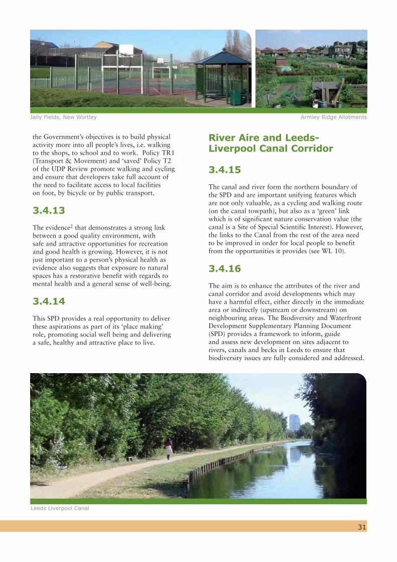
WL.10
WL.4 (ii)
WL.4 (v)
WL.24
WL.23
WL.22
WL.33
WL.18 (c)
WL.4 (iv)
WL.8 (iii)
WL.12
WL.30
WL.8 (ii)
WL.18 (b)
WL.14WL.14
WL.8 (i)
Armley Park
WL.3 (xi)
WL.3 (v iii)
WL.8 (v)
WL.3 (v i)
WL.3 (v)
WL.3 (v ii)
WL.3 (ix)
WL.3 (ii)
Wortley Recreation Ground
WL.3 (iii)
WL.3 (i)
WL.3 (iv)
WL.27
WL.3 (x)
(11)
(65)
WL.8 (iv)
A
Armley Mills
NewWortley
Armley TownCentre
WL.14WL.15
WL.31
Kirkstall Renaissance Area
Stanningley Road
Tong Road
Oldfie ld Lane
Oldfield Lane Centre
Kirkstall Road
A
WL.19
WL.4 (i) WL.16
CA.12WL.20
CA.12WL.14
CA.14WL.17
WL.32
WL.32
CA.14WL.21
WL.35
WL.25
WL.28
WL.2
WL.29
WL.26
This map is based upon the Ordnance Survey’s Digital Data with the permission of the Ordnance survey on behalf of the Controller of Her Majesty’s Stationery Office.© Unauthorised reproduction infringes Crown Copyright and may lead to prosecution of civil proceedings.© Crown Copyright. All rights reserved. Leeds City Council O.S. Licence No. – 100019567 - 2010
PRODUCED BY LEEDS CITY COUNCIL OScale 1:14,000 @ A4
West Leeds Gateway BoundaryNew Wortley (WL.27)
Extension to Armley Town Centre (WL.14)
Employment Protection (WL.34)Site Suitable for Employment (WL.33)
Existing Greenspace (WL.3)Allotments (WL.3)Priority Areas for Greenspace Improvements (WL.4)Proposed Protected Playing Pitch (WL.8)
k Armley Mills Conservation Area
Site Specific Proposal#
Sites Suitable for Housing
A
Mixed Use
Town CentreLocal Centre
West Leeds Gateway Supplementary Planning Document
(X
River
Leeds & Liverpool Canal
Town & Local Centre Boundaries
k Armley Town Centre Conservation Area (WL.1)(11)(65)
Proposed Greenspace (WL.3)
Protected Playing Pitch (WL.8)
Railway Line
( SSSI - Site of Special Scientific InterestSEGI - Site of Geological & Geographic Importance )
West Leeds Gateway Supplementary Planning Document

West Leeds Gateway Leeds Local Development Framework
Supplementary Planning DocumentAdopted October 2010

This publication can also be made available in braille or audio cassette. Please call:0113 247 8092
0113 247 8092
0113 247 8092
0113 247 8092
0113 247 8092
0113 247 8092
If you do not speak English:
If you do not speak English and need help in understanding this document, please phone: 0113 247 8092 and state the name of your language. We will then contact an interpreter. This is a free service and we can assist with 100+ languages.
Write to: WLG Team Forward Planning and Implementation City Development Leeds City Council 2 Rossington Street LEEDS LS2 8HD
Telephone: 0113 247 8092
Email: [email protected]
Web: www.leeds.gov.uk/ldf
Contact Details
Seeking Independent Advice and Support
Yorkshire Planning Aid provides a free, independent and professional planning advice service to individuals and groups from within the Yorkshire and Humber region who cannot afford professional fees. The organisation may be able to assist groups and individuals who would like support and advice in order to get involved in this consultation process.
Contact ourPlanning Advice Helpline:
Telephone: 0870 850 9808
Email: [email protected]
The Studio32 The Calls, Leeds LS2 7EWwww.planningaid.rtpi.org.uk
The Ordnance Survey mapping included within this publication is provided by Leeds City Council under licence from the Ordnance Survey in order to fulfil its public function to act as a planning authority. Persons viewing this mapping should contact Ordnance Survey copyright for advice where they wish to licence Ordnance Survey mapping for their own use.

1
Proposals - a quick reference Pg. 4
1. Introduction Pg. 7
2. Planning Context Pg. 12
3. The 5 Strategic Themes Pg. 20
West Leeds – A Place To Be Proud Of Pg. 22- Historical context- Conservation Areas- Armley Mills A Green & Healthy West Leeds Pg. 26- Protecting greenspace- Improving greenspaces- Health & well being- River & Canal corridor- West Leeds Country Park- Playing fields
A Well Connected Area Pg. 36- Public transport- pedestrian & cycle access (improving connectivity)- Car parking – Armley town centre- Armley gyratory
A Vibrant Town Centre & Local Centres Pg. 42- Central Armley- Local centres
An Attractive Place to Live and Work Pg. 48- Land suitable for housing- New Wortley- Employment land & premises- Education & Training- Outdoor advertising- Signage & Identity
4. Delivery and Monitoring Pg. 60
Appendix 1 Pg. 63– Strategic Delivery and Implementation Plan
Glossary Pg. 84
Footnotes Pg. 88
Contents
© Crown Copyright. All rights reserved. Leeds City Council O.S. Licence No. - 100019567. 2010
32
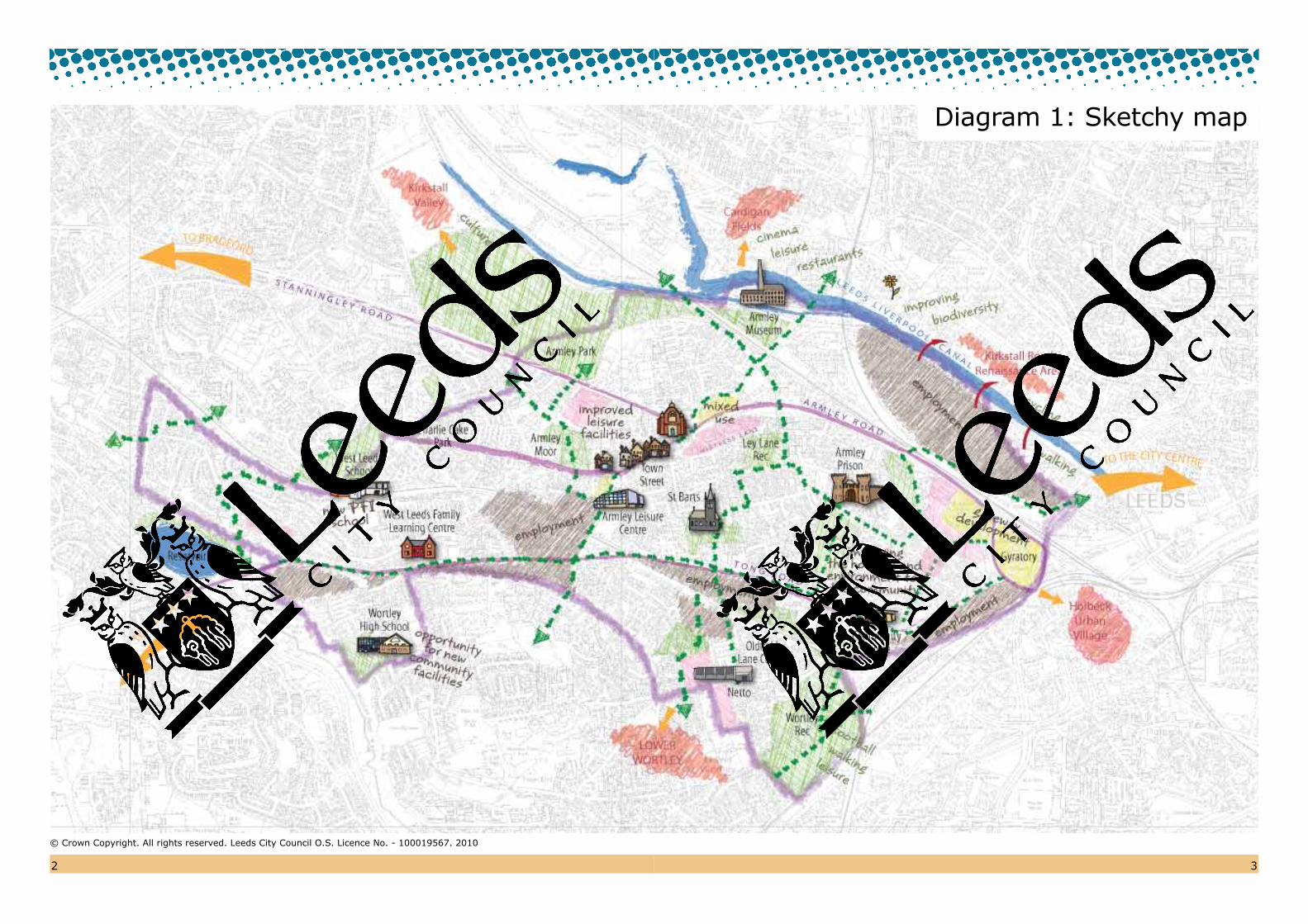
Diagram 1: Sketchy map
4
Proposals – a quick reference
Whingate Junction Cedar Place
STRATEGIC THEME – West Leeds – A Place To Be Proud Of
page no.
WL 1 – Armley Conservation Area – Guidance for new development 23WL 2 – Improving the Armley Mills complex, (including the Industrial Museum) 25
STRATEGIC THEME – A Well Connected Area
page no.
WL 9 – Supporting a feasibility study for improved connectivity on the rail network between Leeds and Bradford 38WL 10 – Promoting the use of the Canal as a pedestrian and cycle route 38WL 11 – Promoting pedestrian and cycle routes along primary links for people to move through
the area to reach key facilities and neighbouring areas 39WL 12 – Integrating the Armley Road area with the Kirkstall Road Renaissance area to the north 39WL 13 – Promoting a comprehensive landscaping scheme along Armley Road 40
STRATEGIC THEME – A Green & Healthy West Leeds
page no.
WL 3 – Protected greenspaces 27WL 4 – Greenspaces prioritised for improvement 30WL 5 – Enhancing the historic interest of the Canal environment 32WL 6 – Flood risk assessment of development proposals alongside canal and river 32WL 7 – Promotion of walking & cycling routes throughout the SPD area 32WL 8 – Protecting playing pitches 33
5
STRATEGIC THEME – Vibrant Town Centres and Local Centres
page no.
WL 14 – Suggested extension to Armley Town Centre 43WL 15 – Implementation of environmental improvements in Armley Town Centre 44WL 16 – Redevelopment or refurbishment of Gelder Road commercial units 45WL 17 – Improvements to the appearance of no. 2 Branch Road – a ‘gateway’ Listed Building 46WL 18 – Supporting and improving local centres at Oldfield Lane, New Wortley and Whingate 47
page no.Diagram 1 – Sketchy Map 2Diagram 2 – Aerial View of the SPD area 6Diagram 3 – Extract from the Leeds Rim Study (Renaissance Leeds) 17Diagram 4 – Location of West Leeds in relation to other Regeneration areas in Leeds 18Diagram 5 – Armley Conservation Area 24Diagram 6 – Armley Mills Conservation Area 25Diagram 7 – Greenspace and Green Links Plan 34Diagram 8 – Connectivity within and around West Leeds 37Diagram 9 – Proposed extensions to Armley Town Centre 43Diagram 10 – SPD Map provided separately
STRATEGIC THEME – An Attractive Place To Live and Work
page no.HOUSINGWL 19 – Land suitable for housing at Far Fold 49WL 20 – Land suitable for housing at Mistress Lane 50WL 21 – Suggested mixed use development, at the ‘Island site’, Armley Road 50WL 22 – Land suitable for housing at Oldfield Lane, (the former Leeds School’s
Sports Association playing pitch) 51WL 23 – Land suitable for housing at Highfield Gardens 51WL 24 – Land suitable for housing at Evelyn Place 51WL 25 – Land suitable for housing on land adjacent to Whingate Primary School(Tong Road) 51WL 26 – Land suitable for housing at Farrow Road 52WL 27 – Regeneration of New Wortley Estate through selective demolition, redevelopment of vacant sites,
refurbishment of existing properties and environmental improvements 53WL 28 – Land suitable for housing at the Former Liberal Club site 53WL 29 – Land suitable for housing at Gassy Fields 54WL 30 – Land suitable for housing at Holdforth Place 54 WL 31 – Proposed ‘shared areas’ in New Wortley to improve pedestrian safety,
car parking and amenity landscaping 55MIXED USEWL 32 – Suggested mixed use development (to include housing & employment) on the
training centre and gyratory site 55EMPLOYMENTWL 33 – Support for the development of employment uses on land at Chelsea Close 56WL 34 – Retention of existing employment uses along Armley Road, Stanningley Road and Tong Road 57EDUCATION/COMMUNITY WL 35 – Safeguarding the Wortley High School site for possible community/educational uses 58ADVERT CONTROL WL 36 – Audit of outdoor adverts to review their planning status and environmental impact 59SIGNAGEWL 37 – Improvement of directional signage to improve accessibility for pedestrians, cyclists and car users 59
6
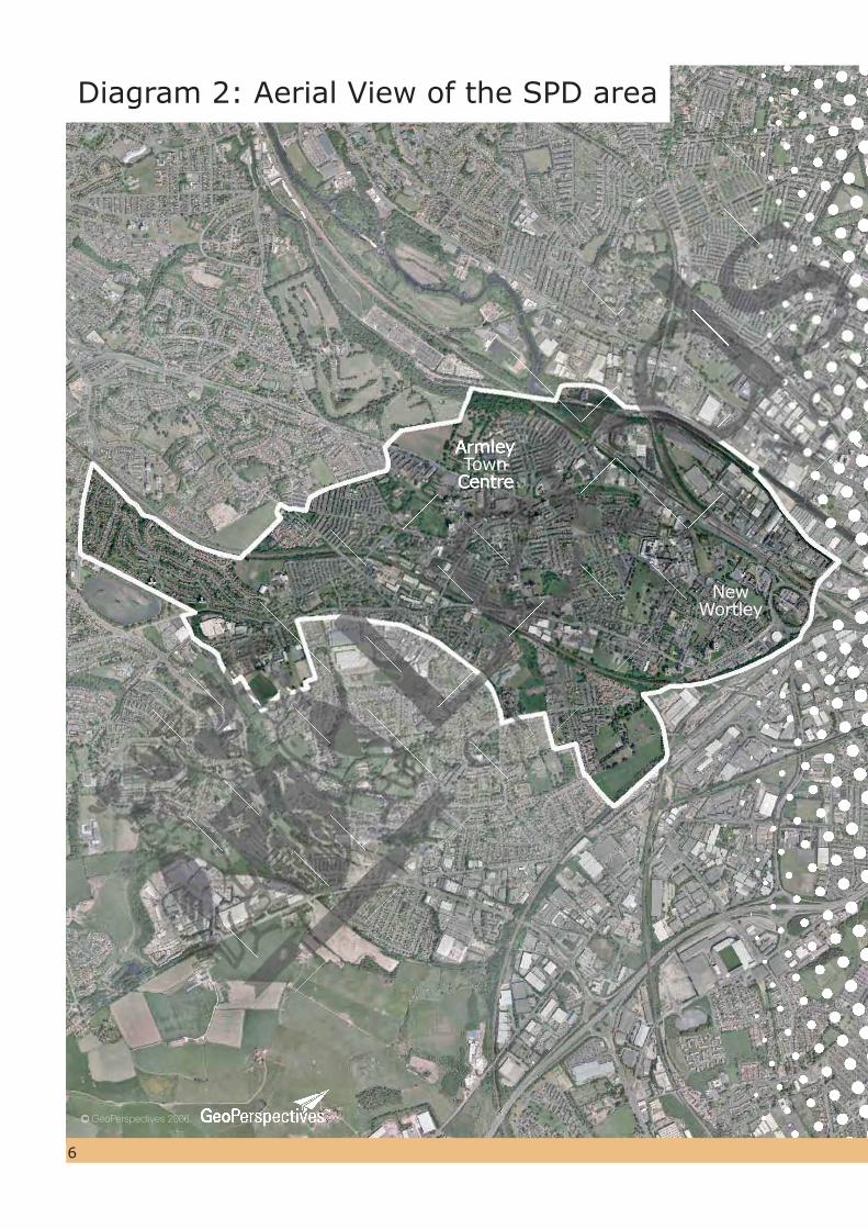
Diagram 2: Aerial View of the SPD area
©GeoPerspectives 2006
Armley Town
Centre
New Wortley
Town
7
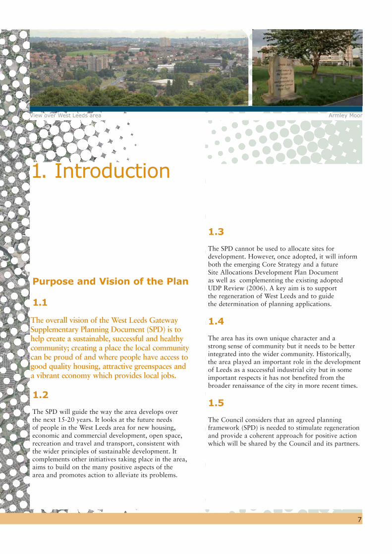
1. Introduction
View over West Leeds area Armley Moor
1.3
The SPD cannot be used to allocate sites for development. However, once adopted, it will inform both the emerging Core Strategy and a future Site Allocations Development Plan Document as well as complementing the existing adopted UDP Review (2006). A key aim is to support the regeneration of West Leeds and to guide the determination of planning applications.
1.4
The area has its own unique character and a strong sense of community but it needs to be better integrated into the wider community. Historically, the area played an important role in the development of Leeds as a successful industrial city but in some important respects it has not benefited from the broader renaissance of the city in more recent times.
1.5
The Council considers that an agreed planning framework (SPD) is needed to stimulate regeneration and provide a coherent approach for positive action which will be shared by the Council and its partners.
Purpose and Vision of the Plan
1.1
The overall vision of the West Leeds Gateway Supplementary Planning Document (SPD) is to help create a sustainable, successful and healthy community; creating a place the local community can be proud of and where people have access to good quality housing, attractive greenspaces and a vibrant economy which provides local jobs.
1.2
The SPD will guide the way the area develops over the next 15-20 years. It looks at the future needs of people in the West Leeds area for new housing, economic and commercial development, open space, recreation and travel and transport, consistent with the wider principles of sustainable development. It complements other initiatives taking place in the area, aims to build on the many positive aspects of the area and promotes action to alleviate its problems.

1.6
The key purpose and objectives of the SPD are to:
1. Provide a catalyst to promote improved joint working between public and private agencies that have a responsibility to improve the health, prosperity and well being of the people of West Leeds.
2. Improve the vitality and viability of Armley Town Centre.
3. Improve the built environment, through promoting high quality design and by preserving and enhancing the area’s heritage to reinforce its distinct identity and sense of place.
4. Help to rejuvenate Armley Mills (Leeds Industrial Museum) as a visitor destination, supported by complementary uses, which will be a focus of local pride, incorporating improved pedestrian and cycle links to the Cardigan Fields Leisure complex in Kirkstall.
5. Improve the quality and usability of greenspace for the enjoyment and improved health and well being of the local community.
6. Contribute to raising educational achievement and employment skills.
8
7. Maintain a variety of employment opportunities.
8. Make the West Leeds Gateway Area a safer and more attractive place in which to live, work and play.
9. Support the provision of accessible neighbourhood facilities, including health care provision, education, training and leisure opportunities.
10. Support the improvement of the existing housing stock, especially the New Wortley Estate, and provide opportunities for the provision of new housing.
11. Improve accessibility for pedestrians, cyclists and public transport users through traffic management measures and links to green corridors. A key aim is to improve linkages to adjoining areas, including the City Centre. The Canal corridor should become the key artery for walking and cycling to the City Centre, and to Kirkstall and the West Leeds Country Park to the West.
1.7
The delivery of these objectives will help to create a more vibrant and successful community which is better connected into the life of the city and where its industrial and cultural heritage is recognised and appreciated by the city as a whole.
1.8
The word “Gateway” in the title of this SPD reflects the fact that the area occupies a pivotal position as both a gateway to the City Centre and to the rest of West Leeds. As such, it signals the Council’s longer term aspirations to spread regeneration activity beyond the boundary of this area, and to link up with similar initiatives taking shape in the Bradford district. It is intended that opportunities to strengthen the links with Bradford along this corridor will be addressed in both Council’s emerging Core Strategies.
Description of the Area
1.9
The SPD area (shown on Diagrams 1 and 2) extends from the edge of Leeds City Centre at the Armley Gyratory in the east to the Heights Estate to the west. It includes the New Wortley Estate; Armley; Lower Wortley; Upper Wortley; the Aviaries; Armley Park; and Wortley Recreation Ground. Overall, it is a mixed area of older private housing, existing and former public sector housing, maisonettes and tower blocks with significant business activity concentrated along Wellington Road, Tong Road and the area to the north of Armley Road.
9
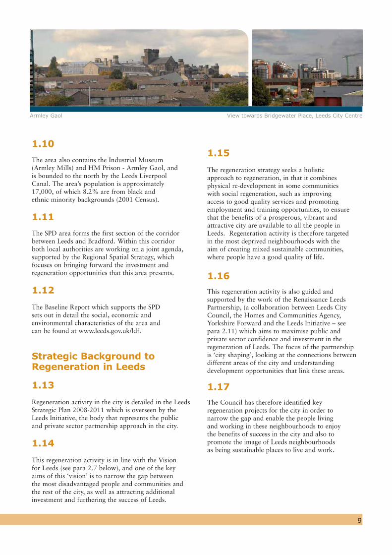
1.10
The area also contains the Industrial Museum (Armley Mills) and HM Prison - Armley Gaol, and is bounded to the north by the Leeds Liverpool Canal. The area’s population is approximately 17,000, of which 8.2% are from black and ethnic minority backgrounds (2001 Census).
1.11
The SPD area forms the first section of the corridor between Leeds and Bradford. Within this corridor both local authorities are working on a joint agenda, supported by the Regional Spatial Strategy, which focuses on bringing forward the investment and regeneration opportunities that this area presents.
1.12
The Baseline Report which supports the SPD sets out in detail the social, economic and environmental characteristics of the area and can be found at www.leeds.gov.uk/ldf.
Strategic Background to Regeneration in Leeds
1.13
Regeneration activity in the city is detailed in the Leeds Strategic Plan 2008-2011 which is overseen by the Leeds Initiative, the body that represents the public and private sector partnership approach in the city.
1.14
This regeneration activity is in line with the Vision for Leeds (see para 2.7 below), and one of the key aims of this ‘vision’ is to narrow the gap between the most disadvantaged people and communities and the rest of the city, as well as attracting additional investment and furthering the success of Leeds.
1.15
The regeneration strategy seeks a holistic approach to regeneration, in that it combines physical re-development in some communities with social regeneration, such as improving access to good quality services and promoting employment and training opportunities, to ensure that the benefits of a prosperous, vibrant and attractive city are available to all the people in Leeds. Regeneration activity is therefore targeted in the most deprived neighbourhoods with the aim of creating mixed sustainable communities, where people have a good quality of life.
1.16
This regeneration activity is also guided and supported by the work of the Renaissance Leeds Partnership, (a collaboration between Leeds City Council, the Homes and Communities Agency, Yorkshire Forward and the Leeds Initiative – see para 2.11) which aims to maximise public and private sector confidence and investment in the regeneration of Leeds. The focus of the partnership is ‘city shaping’, looking at the connections between different areas of the city and understanding development opportunities that link these areas.
1.17
The Council has therefore identified key regeneration projects for the city in order to narrow the gap and enable the people living and working in these neighbourhoods to enjoy the benefits of success in the city and also to promote the image of Leeds neighbourhoods as being sustainable places to live and work.
Armley Gaol View towards Bridgewater Place, Leeds City Centre

Why West Leeds is a Priority Regeneration Area
1.18
Within the strategic context set out above, the need to deliver positive change in West Leeds is compelling. The Baseline Report sets out the underlying reasons which justify intervention by the Council and partner agencies in this area. It is clear from this that the Lower Armley and Upper Wortley area of Leeds has suffered from high levels of deprivation over a number of years. Compared to the rest of the city, the area has more than double the number of workless households, has less than half the levels of educational attainment, has more crime, more empty properties and higher levels of sickness. However, despite such challenges, the area offers considerable potential for improvement.
1.19
The need for multi-agency action to regenerate this part of Leeds was first officially recognised in April 2004 when Leeds Initiative, the Local Strategic Partnership, approved the establishment of a ‘West Leeds Gateway Regeneration Area’ in order to help:
Narrow the gap between the poorest areas of the city and the rest
Assist Leeds in realising the city’s full economic potential as a regional capital
1.20
The prioritisation of West Leeds for regeneration has been subsequently recognised in reports to the Executive Board (May 2005), Vision for Leeds (2004-20) – the Community Strategy, Leeds Regeneration Plan (2005-8), West Leeds District Partnership – Strategy for Success (Action Plan 2005-8) and the Council Plan (2007-8).
10
1.21
However, the case for prioritising the regeneration of West Leeds lies not only in its levels of deprivation, but also in the realistic opportunities for sustainable intervention by the Council and other agencies. The area’s locational and physical assets that offer opportunities for real progress to be made may be summarised as follows:
A strong sense of community and local identity
close proximity to the City Centre and opportunities for improved connectivity
a key location within the Leeds-Bradford corridor where there is a joint regeneration agenda between the two cities (ref: Policies LCR1 and LCR 2 of the Regional Spatial Strategy)
a compact town centre in Armley
key ‘landmark’ sites with potential for striking, transformational redevelopment
a valuable built heritage, including Armley Mills, Leeds Prison and St. Bartholomew’s Church
an abundance of greenspaces and networks which provide spaces for recreation and the opportunity to facilitate healthy lifestyles.
A thriving local economy
A good variety of housing
1.22
Producing the SPD has been a collaboration between the Council, local communities, businesses and other local organisations. Ongoing joint working between these agencies is continuing to help create a strong sense of place and give spatial expression to the aspirations of the wider community.
Holdforth Place, New Wortley Gelder Road

11
How the Plan has Been Prepared
1.23
Work on a regeneration plan for West Leeds started in 2005 with a process of community consultation to help identify key challenges and drivers for change. This culminated in the production of an ‘Issues and Alternative Options Paper’ (Area Action Plan) in Autumn 2006 which set out broad options for the future of West Leeds, which were dependant upon different levels of intervention.
1.24
The local community and other stakeholders were consulted over a 6 week period on these options and the comments received were used to prepare a ‘Preferred Options’ document which was published for comment over a 6 week period between February and April 2008. The document was subsequently changed to become a Supplementary Planning Document (SPD) and a further 6 week period of consultation was undertaken between 15th June and 27th July 2010. The SPD was adopted by the City Council's Executive Board on the 13th October 2010.
1.25
The SPD has therefore evolved and the Council believes that it addresses the key issues that were identified at the outset. The public consultation process and the outcomes (including changes made to it) have been drawn together in a “Consultation Statement" (Supporting Document 2).
1.26
A key objective running through the whole of the SPD is to ensure that the proposals which emerge are inherently sustainable and represent the best choice for people, the environment and the local economy.
The baseline study justifies how the proposals in the SPD are best suited to addressing the key issues and opportunities for the area that were identified at the outset. The Baseline Study is available on request or can be found online at www.leeds.gov.uk/ldf.
1.27
The supporting documents to the SPD are listed below:
Supporting Documents
1. Baseline Study
2. Consultation Statement
3. PPG 17 Study – Needs Assessment
4. PPG 17 Study – Children’s & Young People’s Consultation Report (2008)
5. New Wortley Community Plan (2009)
6. Armley Conservation Area Appraisal
Community Consultation Armley One Stop Centre
Oldfi eld Lane
12
2.2
Of particular relevance is the Government’s Sustainable Communities agenda which is a long term programme to create places where people want to live and work, now and in the future. A sustainable community should:
Meet the diverse needs of existing and future residents
Be sensitive to the environment Contribute to a high quality of life Be safe and inclusive Be well planned and built Offer equal opportunity and
good services to all.
National Policies
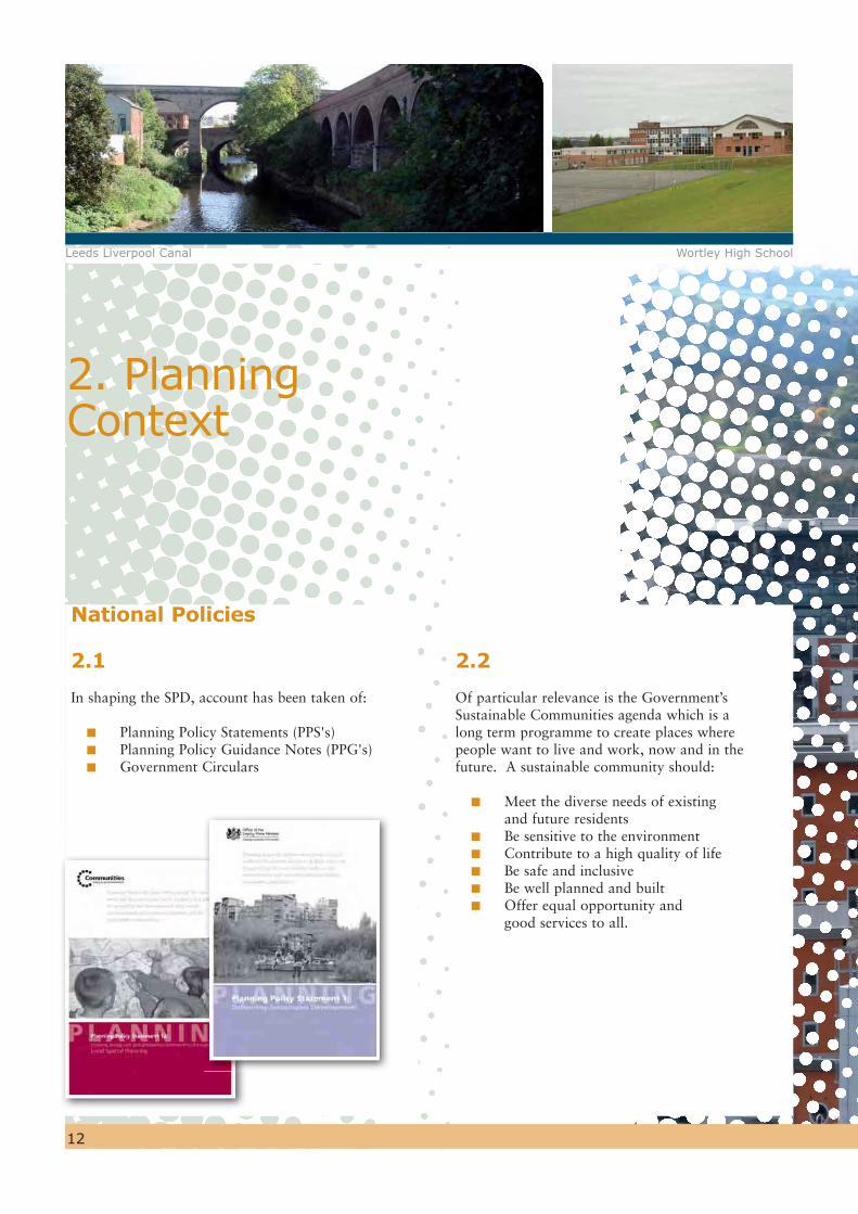
2.1
In shaping the SPD, account has been taken of:
Planning Policy Statements (PPS's) Planning Policy Guidance Notes (PPG's) Government Circulars
2. Planning Context
Leeds Liverpool Canal Wortley High School
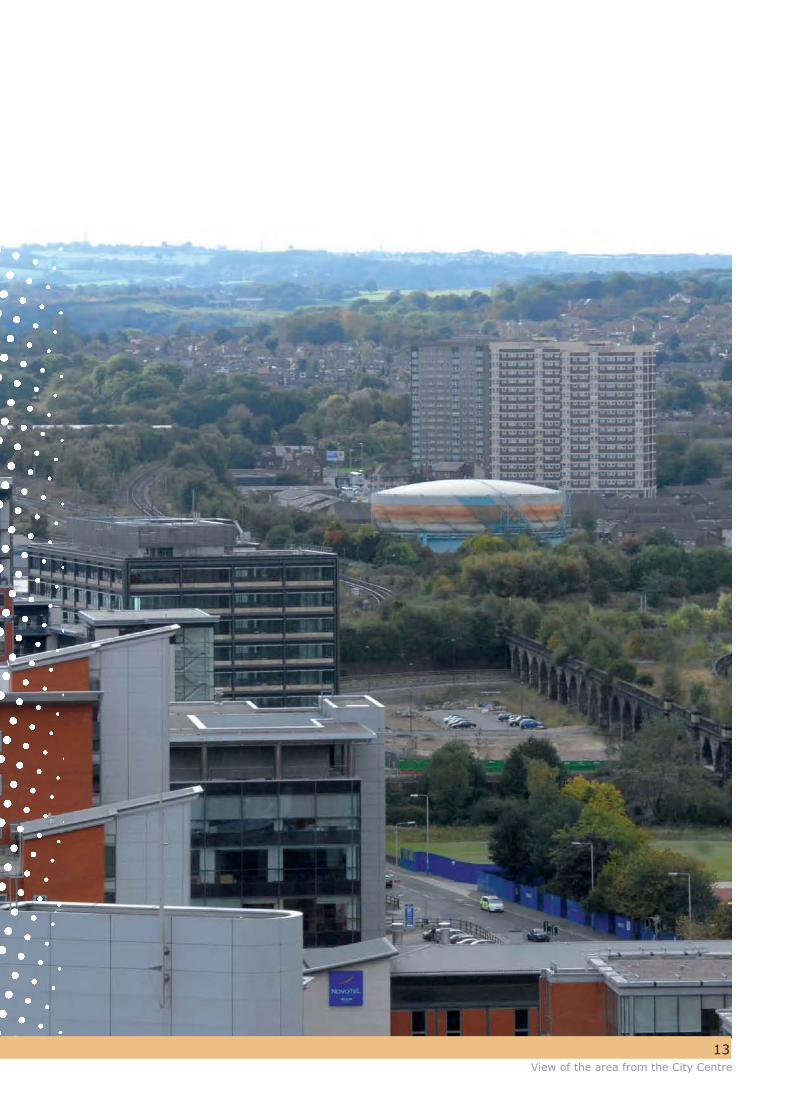
13View of the area from the City Centre

14
Regional Policy
2.3
The Leeds City Region Investment Plan (2010-2014) sets out the investment programme(s) for the Homes and Communities Agency and other complementary public sector funding to deliver city-region housing and regeneration strategic ambitions. Within this broad Investment Plan, the Leeds-Bradford Corridor is seen as a strategic theme for urban renewal. The corridor stretches for nine miles between the city centres of the first and third largest economies in Yorkshire and the Humber. The key aim of identifying the renewal area is to facilitate cross-boundary collaboration to accelerate investment activity and to make the Leeds-Bradford Corridor a leading example of collaborative place making in the UK.
2.4
To help deliver these regeneration objectives, a partnership between the two local authorities has been established. This seeks to build on the current strengths of Leeds and Bradford through joint working and to use the economic growth of the respective city centres to benefit the deprived urban areas that lie between them. The area covered by the SPD represents the easternmost section of this corridor and will provide a catalyst for regeneration and improved transport links within the broader corridor.
Local Policy
Vision for Leeds
2.5
The Community Strategy for Leeds (Vision for Leeds 2004 to 2020) has the following main aims:
‘Going up a league as a city’ making Leeds an internationally competitive city and the best place in the country to live, work and learn, with a high quality of life for everyone.
‘Narrowing the gap’ between the most disadvantaged people and communities and the rest of the city.
‘Developing Leeds’ role as the regional capital’, contributing to the national economy as a competitive European city, supporting and supported by a region that is becoming increasingly prosperous.
Castleton Mills and Leeds Liverpool Canal

15
2.6
The SPD has the potential to contribute to all three aims of the Community Strategy:
going up a league – creating a sustainable living and working environment which raises the image of the area;
narrowing the gap – enabling local people to take advantage of the opportunities presented by the regeneration of the area and its improved integration with adjoining neighbourhoods;
developing Leeds as a regional capital – the proximity of the area to the city centre and surrounding neighbourhoods such as Holbeck Urban Village, gives it the potential to make a significant contribution to the future long term growth and success of the City.
The Leeds Strategic Plan
2.7
The Leeds Strategic Plan (2008 to 2011) sets out the strategic outcomes and improvement priorities which have been agreed following extensive consultation with councillors, stakeholder
groups and the public across the city. The Leeds Strategic Plan is also the Local Area Agreement for Leeds, a formal agreement with central government about how to improve outcomes on shared priorities. The contents of the Strategic Plan are aligned with the Vision for Leeds (2004 to 2020) and can be seen as the delivery plan for the Vision for Leeds.
2.8
At the heart of the Leeds Strategic Plan is the ambition to transform the quality of life in Leeds to see:
people happy, healthy, safe, successful and free from the effects of poverty;
young people equipped to contribute to their own and the city’s future well being and prosperity;
local people engaged in decisions about their neighbourhood and community and helping to shape local services;
neighbourhoods that are inclusive, varied and vibrant offering housing options and quality facilities and free from harassment and crime;
an environment that is clean, green, attractive and above all, sustainable; and
a city-region that is prosperous, innovative and distinctive enabling individuals and businesses to achieve their economic potential.
The Renaissance Leeds Strategy
2.9
The Renaissance Leeds Partnership, a collaboration between the City Council, Yorkshire Forward, the Homes and Communities Agency and the Leeds Initiative, was formed in 2005 in order to oversee the physical and spatial development of the city. An earlier Renaissance Leeds report1 published by Leeds City Council and Yorkshire Forward in 2004, saw West Leeds as one of the “spokes” – driven by the growth of the city centre – but ‘dis-connected’ from it and not sharing in the wealth it creates.
2.10
The SPD area is specifically described as forming part of a “Rim of Disconnectivity,” (see diagram 3) owing to the way in which the community has been severed from the city centre and other communities by motorways, other road systems and railways. The overall effect is poor connectivity and an absence of a good quality public environment which undermines the area's identity and character.
2.11
The SPD addresses the above issue by seeking to increase the permeability of the area, connecting it into the wider “rim” around the city centre and to the city centre itself.
16
Unitary Development Plan
2.12
The Revised Unitary Development Plan (2006) forms part of the Development Plan for Leeds and remains an important policy context for this SPD. The SPD effectively translates the regeneration objectives contained in the adopted Leeds Unitary Development Plan Review (2006) into delivery on the ground.
2.13
As a consequence of changes to the Development Plans system introduced by the Planning & Compulsary Purchase Act 2004, the Secretary of State has agreed that the majority of UDP Policies can be saved until they are replaced by new policies in an adopted Development Plan Document, prepared under the Local Development Framework.
2.14
The schedule of UDP Policies which are ‘saved’ and which will continue to apply to the West Leeds Gateway area can be viewed at www.leeds.gov.uk/UDP.
The Core Strategy
2.15
The emerging Core Strategy sets out the vision for the future of Leeds over the next two decades and provides broad policies to shape development. All other documents prepared as part of the Local Development Framework, including
this SPD, have to fit with the Core Strategy and contain policies and proposals which support its strategic vision. The SPD has therefore been informed by the emerging Core Strategy at every stage.
2.16
The SPD aims to tackle environmental, economic and social issues in an integrated way and contribute to the delivery of the Core Strategy by:
enabling a deprived neighbourhood to share in the success of the city and increase prosperity
contributing to a wider urban renaissance creating an attractive place which is good to
live and work in helping to create a well-connected city developing a healthy local economy and a
successful town centreRaising the quality of greenspaces to help improve people’s health and well being.

KeyWest Leeds GatewayCity CentreOther Regeneration AreasRIM AreaLeeds - Bradford Corridor
17
Links to other Regeneration Areas
2.17
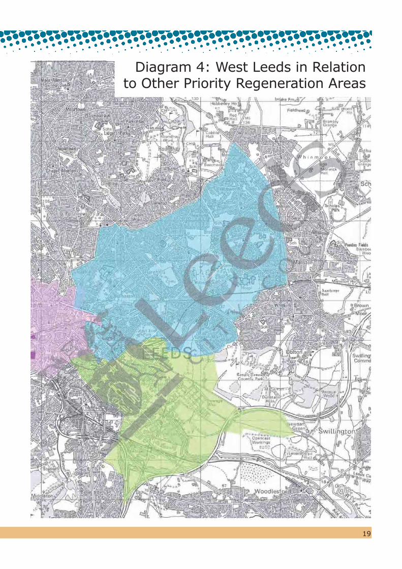
Diagram 4 shows the SPD in relation to the other priority regeneration areas in Leeds. It is proposed that opportunities will be taken to improve links with the Kirkstall Renaissance Area, the City Centre, the City Centre Rim and Holbeck Urban Village.
Diagram 3: Extract from the RIM study (Renaissance Leeds)
© Crown Copyright. All rights reserved. Leeds City Council O.S. Licence No. - 100019567. 2010
R

18
© Crown Copyright. All rights reserved. Leeds City Council O.S. Licence No. - 100019567. 2010
19
Diagram 4: West Leeds in Relation to Other Priority Regeneration Areas

20
3. The 5 Strategic Themes
3.1
3.1 Central to the Council’s approach in moving towards the achievement of the long term objectives described in para.1.6 above, is that the principles of sustainability are fully integrated into the Plan. There is a particular emphasis on areas of change where policies and proposals are designed to provide long-lasting benefits to the area with the objective of creating a vibrant neighbourhood and providing opportunities to access employment and community facilities.
New Wortley Estate Armley Library
3.2 Within the context of higher level principles of sustainability is the desire to take practical action at a local level. The following five strategic themes for action have therefore been identified which address the key issues of specific relevance to West Leeds. The themes are:
West Leeds – A Place to be Proud of
A Green and Healthy West Leeds
A Well Connected Area
Vibrant Town and Local Centres
An Attractive Place to Live

21View towards St Bartholomew's
22
3.3.3
Armley was well located for trade, being close to the Leeds and Liverpool Canal (completed in 1816) which at the time of the Industrial Revolution provided the most important transport link for the movement of wool and other goods. The railways also left their mark on the area and remain significant features. At one time there were two stations in Armley with significant sidings and connections to local industry. Canal Road, between Armley Mills and Stanningley Road was the focus of much of the industrial production, with a number of buildings remaining from that time.
3.3.4
To house the significant influx of new workers, there was a massive expansion of terrace houses between 1861 and 1932. Much of this housing remains, although many areas were cleared in the post war period and were replaced with high rise blocks, such as Burnsall Grange and Croft to the north of Armley Town Street. Significant areas of dense terrace housing were also cleared to create the New Wortley Estate, laid out in the then fashionable ‘Radburn’ style.
3.3.5
The area is also characterised by areas of greenspace which reflect the history of the area, including parks, allotments and cemeteries. Armley Park once formed the grounds of Armley House (Gotts Park) and stretches from Stanningley Road down towards the Leeds and Liverpool Canal. Armley Moor, just outside the Town Centre, is informal in nature and was formerly a tenter field for the drying of wool.
3.3.6
Reflecting the historical legacy of the area, there are a number of listed buildings in the area including Grade II* listed Armley Gaol, St Bartholomew's Church and part of the Armley Mills complex, which is also designated as a Conservation Area. A new Conservation Area for central Armley focussing around Armley Town Street was designated on 19th October 2007.
History - the factors that have helped to shape West Leeds
3.3.1
The historic legacy of the area, particularly its listed buildings and Conservation Areas, should play an important role in the area’s regeneration, increase tourism and be a source of local pride which is equally valued by the city as a whole.
3.3.2
The built form of the area still reflects the origins of Armley as a village and its rapid growth during the industrial expansion of Leeds from the late 18th Century. This expansion was largely as a result of the growth of the textile industry from small weavers cottages (some remain at the western end of Town Street) to large textile mills, most notably Armley Mills on Canal Road, built by Benjamin Gott in the early 1800s, and at one time the world’s largest woollen mill.
3.3 West Leeds - A Place to be Proud of
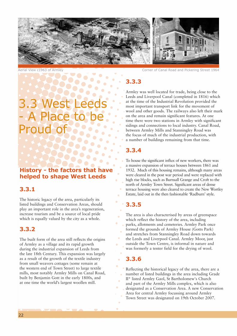
Aerial View c1963 of Armley Corner of Canal Road and Pickering Street 1964
23
Conservation Areas
Central Armley
3.3.7
A Conservation Area Appraisal was adopted in October 2007 by the City Council as non-statutory planning guidance and this explains its special character and attributes, highlighting particular areas for enhancement. In addition, a management plan has also been drawn up for the area which sets down measures to maintain and enhance that special character. Both these documents are complementary to saved UDP policies (policies N14-22 of Volume 1 and BC1-9 of Volume 2).
3.3.8
It is important that buildings which make a positive contribution to the Conservation Area are retained in accordance with the considerations at para. 3.19 of Planning Policy Guidance Note 15. ‘Positive’ buildings which contribute to the special character or appearance of the Conservation Area are identified in the Armley Conservation Appraisal. New development is encouraged in the Conservation Area as long as it does not detract from its special character or appearance. In this respect, new buildings do not have to slavishly copy existing buildings but there should be a respect for fundamental spatial and architectural characteristics.
3.3.9
A key objective in the Conservation Area is to retain traditional shop fronts and to take opportunities to re-instate those which may have been ‘modernised’ so that they are appropriate to the building. Signage applied to the shop fronts is also important to the character and appearance of the Conservation Area. New signage should therefore avoid cluttering the street scene.
3.3.10
The elevated position of Armley and the location of important buildings in prominent positions mean that views into and out of the Conservation Area are important. For example, St Bartholomew’s Church is a landmark building which is important to the image and identity of Armley. It is recognised that development both within and immediately adjacent to the Conservation Area could potentially have a harmful effect. Therefore every effort should be made to enhance these views, including long distance views, and avoid visual harm to its setting. Key views are identified in the Armley Conservation Area Appraisal (supporting document 6).
3.3.11
The public realm (highways and other publicly owned spaces) provides the setting for historic buildings and it is important that every effort should be made to keep traditional materials and reinstate appropriate high quality materials and street furniture. Therefore, the siting and design of road signs and street furniture in the Conservation Area should be sympathetic to the area’s historic character and have regard to the current ‘Streets for All’ guidance.
WL 1Proposals for development within the Armley Conservation Area should reflect the following principles: (i) ‘positive’ buildings should be retained
unless it can be shown that it is not viable or the replacement preserves or enhances the Conservation Area.
(ii) new development should respect the form and character of spaces. Therefore, the infilling of gardens and other open spaces will only be permitted if it preserves or enhances the character or appearance of the Conservation Area.
(iii) the replacement of traditional shop fronts will be resisted and their repair encouraged.
(iv) new buildings should respect the siting, massing, form, proportions and materials of adjoining buildings.
"We endorse the identification of the area’s rich heritage as one of the key opportunities which can assist in the area’s Regeneration” (English Heritage)
To make West Leeds a place to be proud of, celebrating its industrial heritage and architectural quality

3.3.13
The Mill has great potential due to its close proximity to the City Centre and unique position on the Leeds Liverpool Canal (part of National Cycle Network Route 66) and the River Aire. It is only 800m from Armley Town
Street, yet the Mill does not connect well with the Armley area generally due to poor pedestrian links. Equally, it is also poorly connected into the Cardigan Fields Leisure Complex which lies immediately to the north across the river. There would be clear mutual benefits in
having stronger pedestrian links between the two complexes.
“The museum should bedeveloped to
include a possible shop and cafe and made more
accessible”
24
Armley Mills
3.3.12
Armley Mills is a Listed Building (Grade II &II*) of great attractiveness, with a unique setting and considerable architectural and historic value. It has housed the Leeds Industrial Museum, telling the story of the City’s diverse industrial heritage, since 1982.
To breathe new life into the industrial museum at Armley Mills and improve its physical links with Cardigan Fields Leisure complex
Diagram 5: Armley Conservation Area
© Crown Copyright. All rights reserved. Leeds City Council O.S. Licence No. - 100019567. 2010

3.3.14
To the rear of the Museum car park is Dunkirk Hill, an area of greenspace which is managed by the Council. This was originally laid out as a picnic area and whilst it offers good views of Leeds from its summit, its design and purpose is now outdated and it has become a focus for anti social behaviour. The consequence of this is that the main approach to the Museum is unattractive and uninviting.
3.3.15
However, despite these negative features, visitor numbers to the Museum are improving in response to new events and exhibitions and it is considered that there is further scope for improvement.
3.3.16
Parts of the overall complex are now in need of investment and in order to maintain and further improve the Museum’s attractiveness and long term future, the following actions should be considered:
accommodating a complementary use(s) in part of the Mill complex
improving the adjoining greenspace at Dunkirk Hill
improving the car park and by providing an attractive ‘gateway’ or entrance feature which would give the Museum a higher profile
improving the pedestrian link with the Cardigan Fields Leisure complex to the north of the River Aire.
3.3.17
The suggestion of accommodating an ancillary use(s) at the Museum is designed to help underpin the Museum’s long term future as a visitor attraction, and this is under investigation. Creating space for such uses would need to be done by consolidating and relocating some of the Museum's collections within the Mill complex to free up space. If this is possible, the emphasis would be upon introducing uses which would complement the Museum’s role and help to strengthen it as a visitor attraction. This
25
will be done in the context of improving other waterfront attractions along the Aire Valley.
3.3.18
A long term solution to the future of the area in which the Museum is located is needed and a comprehensive approach, developed through a planning brief, will guide any further development.
WL 2The City Council will, in consultation with the Environment Agency and British Waterways (and as necessary other agencies), prepare a planning brief to promote the regeneration of the Armley Mills complex, including the adjoining Dunkirk Hill in order to:
(i) take account of the Leeds Flood Alleviation Scheme objective of reducing flood risk to the Armley Mills site and adjoining properties
(ii) facilitate improved pedestrian connectivity between the Mills and Kirkstall Leisure Complex at Cardigan Fields;
(iii) support the rationalisation of museum floorspace to facilitate the occupation of complementary uses;
(iv) improve the adjoining Dunkirk Hill as an area of greenspace and a more attractive entrance to the museum
(v) improve car parking to support the museum and other potential uses
(vi) improve pedestrian access from Dunkirk Hill to the Canal and Kirkstall Nature Reserve beyond
(vii) improve biodiversity across the site(viii) explore the utilisation of low or zero carbon
energy sources at the Mill complex, to include solar, wind and water power.
Diagram 6: Armley Mills Conservation Area
Armley Mills Industrial Museum

26
purposes of the study into 10 geographic areas, including ‘West Inner’ which covers the SPD area. The following conclusions for this area are summarised below.
3.4.3
Compared to the district-wide position, the views of West Leeds residents were that there are not enough:
natural areas children’s play areas allotment gardens tennis courts
3.4.4
A key finding across ‘West Inner’ in common with other parts of Leeds, was that the majority of respondents have a strong preference for being able to walk to a range of facilities: parks & gardens, amenity areas, children’s playgrounds, teenage facilities and grass pitches.
Consulting Children and Young People
3.4.5
In order to obtain the views of young people within the area, the Council worked alongside Leeds Primary Care Trust to consult children and young people in West Leeds in order to better understand how they felt about their local environment and to identify changes that could be introduced to improve their health and well-being.This included their use and access to greenspaces and the routes they use to move around the area. The ‘Children & Young People’s Consultation Report (2008)’ is Supporting Document 4.
3.4.1
The poor condition of greenspace in West Leeds and the need to improve it was a key issue raised by people during early consultation. Consequently, a key aim is to create well designed, safe (e.g. overlooked), high quality and accessible greenspaces which will give the area a strong sense of place which local people can enjoy and use for active or informal recreation. As well as being a source of community pride and attracting new investment, improved greenspaces will make a positive contribution to raising the quality of life for all sections of the local community and encourage healthier lifestyles.
3.4.2
In 2008/9 the Council carried out an ‘Audit’ of greenspace in Leeds and a ‘Needs Assessment’ under the guidelines contained in Planning Policy Guidance Note17 (PPG17). The primary purpose of this study is to inform the emerging Core Strategy for Leeds and other local development documents, as well as this SPD. Supporting Document 3 explains the methodology employed in carrying out this work and the way in which the Leeds district was sub-divided for the
3.4 A Green and Healthy West Leeds
Strawberry Lane / St Bartholomew's Churchyard Armley Park
27
3.4.6
The key findings of that study were as follows:
the major concerns of young people when moving around their local community were traffic, the people they meet and the buildings they have to walk past. They thought that marking out safer routes, including the best road crossing points, and telling pupils through school assemblies about these routes was a good idea.
The same concern was expressed about getting to and from Parks, making sure everyone knows about the best and safest routes which are shared by everyone, not just children.
Traffic was a major concern, with children commenting that many drivers speed and do not slow down in areas where children and young people are, e.g. schools, parks, leisure centres
Parks need to be improved as many had broken or no equipment. More exciting equipment and other additions are needed to make them more attractive. Teenagers were often cited as those responsible for vandalism. However, when asked, teenagers identified young adults as those responsible and felt threatened by them, preventing them using facilities such as Multi-Use Games Areas.
Children and young people thought that parks were only accessible if local, within a reasonable walking distance and on a safe route. Parents would not allow their children to go to parks if they had to go through an unsafe area or they felt the park was in an unsafe area.
Children and young people recommended that:
a) equipment should be provided for all age groups in separate areas, but that these should be visible and not hidden away.
b) equipment and activities should include traditional and non-traditional, e.g. swings, skate parks, youth shelters, benches, mini golf, multi-use games areas, things to climb, bins, flowers, ponds, toilets and refreshments,
c) parks should be cleaner and looked after.
Protecting greenspaces in West Leeds
3.4.7
The PPG17 Audit of greenspace provision is nearing completion (May 2010) and revised standards of greenspace provision will be formulated for the whole of the Leeds Metropolitan District at the conclusion of this study. However, the PPG17 Audit is clearly showing that some of the area’s greenspaces are poorly maintained, unattractive and not fully used or appreciated.
3.4.8
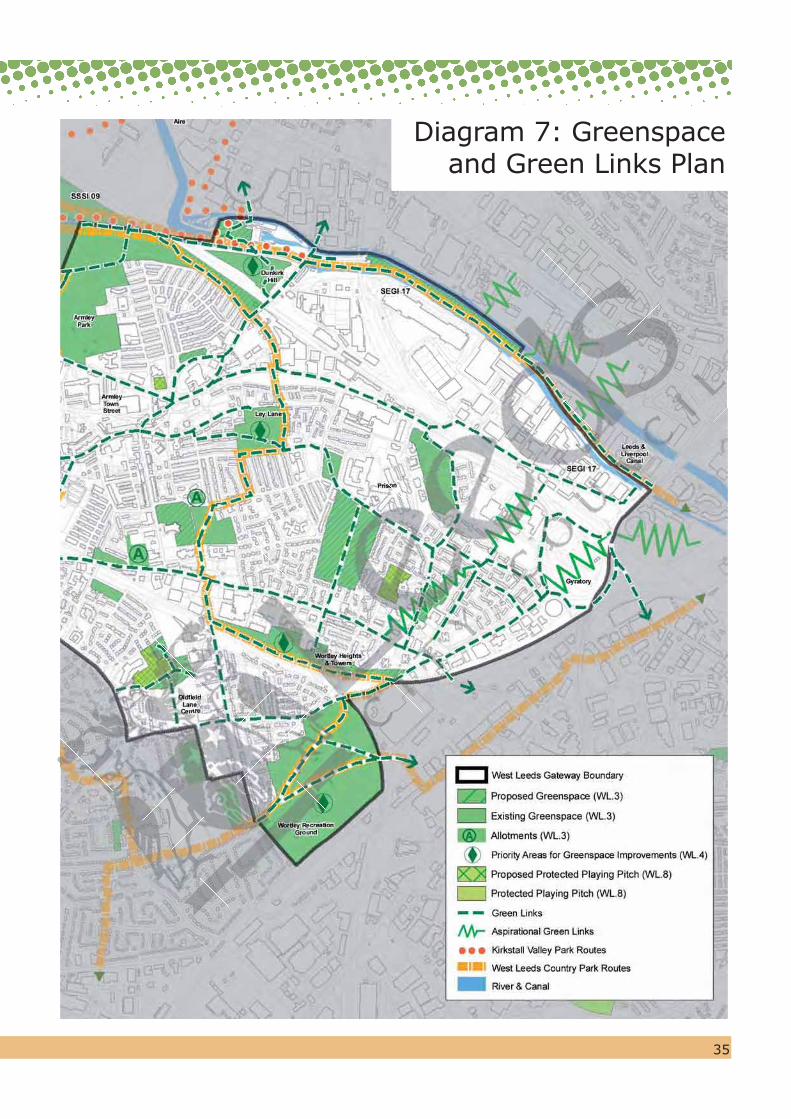
Within the SPD area, 21 greenspaces, covering a total area of 44 ha. are already protected under ‘saved’ Policy N1 of the UDP. Some of these areas continue beyond the SPD boundary and the total area (gross) extends to 92 ha. which are accessible to the local community. The SPD proposes the addition of 11 sites of over 0.2 ha. to those already protected under UDP Policy N1. It is proposed that the these additional sites will eventually be incorporated into Leeds' Site Allocations Development Plan Document, which will replace/update the land use allocations in the current Unitary Development Plan. The sites are:
i) Land adjacent to the railway at Moor End and at College Lawn (0.6 ha)
ii) Area to the south of Wortley Heights and Towers along the side of the railway line (2.8 ha), which has the potential to become a green link and already forms an integral part of the Leeds Core Cycle Network.
iii) Open space adjacent to Five Lanes Primary School, an area of public open space laid out as part of the development of the school (0.94 ha).
iv) Land between the Canal and River Aire, (part of Yorkshire Chemicals Site) (1.2 ha).
v) Churchyard at St Bartholomew’s Church (0.89 ha).vi) Allotments adjacent to the Mosque at Hall
Lane and Brooklyn Terrace (0.2 ha).vii) New Wortley Cemetery (2.3 ha). viii) Land between Canal Road, the railway
and Armley Park Road (1.0 ha)ix) Land adjacent to Phil May Court,
New Wortley (0.4 ha)x) Ledgard Way/Salisbury Grove (0.8 ha)xi) Armley Mills (0.6 ha)
WL 3The greenspace sites listed above are identified on the proposals map and will be protected from development in addition to those already protected under Policy N1 of the UDP.
“Some areas of open land and other small patches of underdeveloped land, could be developed as greenspace,
in denser housing areas”.

28
for investment in order to restore it to its former glory. However, the site’s overall management is poor, with inappropriate and unauthorised horse grazing, poor infrastructure (such as seats, litter bins and paths) and a generally unwelcoming environment.
2. Ley Lane
Ley Lane is another area of greenspace which is very accessibile to the local community. However, it performs a different function to Armley Moor in that it caters for active sport. The site scored poorly in the PPG17 audit and could benefit from signage, improved facilities on site and better maintenance.
Improving greenspaces
3.4.9
In addition to continuing to protect greenspaces, an important aim of the SPD is to improve their overall quality and attractiveness so that more local people will use them for active or passive recreation. Armley Park is a key local asset which also serves a wider area of West Leeds. The Council will continue to invest in raising the quality of this Park in order to achieve ‘Green Flag’ status. Achieving high quality greenspaces is a key part of successful ‘place making’ and will address the concerns expressed by residents about their poor condition compared with parks and greenspaces in other parts of the city. Based on the PPG17 Audit and upon the wider potential regeneration benefits of particular sites, a number of priorities for improvement have been identified. Some of the areas are managed by the Armley Common Rights Trust and new partnership arrangements between the Trust and the Council are needed to facilitate this. The sites identified for priority spending are listed in WL 4. These are:
1. Armley Moor
Armley Moor is an informal greenspace centrally located adjacent to Armley Town Centre. The Armley Conservation Area Appraisal considers Armley Moor to be the most important open space in the Conservation Area and highlights the need
Armley Moor

29
3. Dunkirk Hill
Dunkirk Hill is a ‘semi-natural’ greenspace which is located adjacent to Armley Mills. Unfortunately, management issues have led to the site gaining a negative reputation. The site has therefore been prioritised for improvements which may consist of opening up the site visually, improving security and surveillance and the creation of an improved entrance to Armley Mills. Detailed proposals will be brought forward as part of a comprehensive scheme for the improvement of the whole Armley Mills complex (refer to WL 2).
4. Area to the south of Wortley Heights and Towers
This is a green corridor which forms part of the West Leeds Country Park route through the area. The corridor follows the railway line westwards through informal greenspace and past rugby and football pitches. This area of greenspace has the potential to be a very attractive route through the area but requires significant investment to improve its accessibility and usability.
To improve the quality of greenspaces making them more
attractive for people to use, adding to the attractiveness of
the area generally and improving people’s sense of well-being
Ley Lane
Dunkirk Hill

5. Wortley Recreation Ground
Wortley Recreation Ground is a valuable community park but it requires significant investment in order to bring it up to ‘Green Flag’ standards. In addition to improvements to the formal and informal parkland areas, the playing pitches require drainage improvements in order to make them more useable throughout the year.
30
WL 4The protected greenspaces shown on the SPD Plan which have an additional dark green ‘diamond’ notation, will, subject to monitoring and review, be given priority in spending programmes in order to raise their quality and attractiveness to the local community and facilitate better connectivity within the SPD area and neighbouring communities.The sites identified are:
i) Armley Moorii) Ley Laneiii) Dunkirk Hilliv) Area to the south of Wortley Heights
and Towersv) Wortley Recreation Ground
3.4.10
The provision of new or improved ‘greenspace’ (or improvements to public space generally) will also be sought in commercial developments where this provides an opportunity to link up or improve access to nearby greenspaces.
Health & Well-Being
3.4.11
Evidence2 shows that the West Leeds area suffers from higher levels of sickness than the District average and the spatial planning for the area therefore seeks to provide the infrastructure to encourage healthier lifestyles, such as safe routes for walking and cycling as well as better quality greenspaces. There is clearly a strong relationship between the protection and improvement of greenspaces and the opportunity to contribute to improved health and a sense of well being in the community.
3.4.12
It is important to appreciate that issues relating to good health are cross-cutting and are therefore relevant to a number of policy areas in the SPD, especially the promotion of walking and cycling and the broader aim of improving connectivity. One of
31
River Aire and Leeds-Liverpool Canal Corridor
3.4.15
The canal and river form the northern boundary of the SPD and are important unifying features which are not only valuable, as a cycling and walking route (on the canal towpath), but also as a ‘green’ link which is of significant nature conservation value (the canal is a Site of Special Scientific Interest). However, the links to the Canal from the rest of the area need to be improved in order for local people to benefit from the opportunities it provides (see WL 10).
3.4.16
The aim is to enhance the attributes of the river and canal corridor and avoid developments which may have a harmful effect, either directly in the immediate area or indirectly (upstream or downstream) on neighbouring areas. The Biodiversity and Waterfront Development Supplementary Planning Document (SPD) provides a framework to inform, guide and assess new development on sites adjacent to rivers, canals and becks in Leeds to ensure that biodiversity issues are fully considered and addressed.
Jaily Fields, New Wortley Armley Ridge Allotments
the Government’s objectives is to build physical activity more into all people’s lives, i.e. walking to the shops, to school and to work. Policy TR1 (Transport & Movement) and ‘saved’ Policy T2 of the UDP Review promote walking and cycling and ensure that developers take full account of the need to facilitate access to local facilities on foot, by bicycle or by public transport.
3.4.13
The evidence2 that demonstrates a strong link between a good quality environment, with safe and attractive opportunities for recreation and good health is growing. However, it is not just important to a person’s physical health as evidence also suggests that exposure to natural spaces has a restorative benefit with regards to mental health and a general sense of well-being.
3.4.14
This SPD provides a real opportunity to deliver these aspirations as part of its ‘place making’ role, promoting social well being and delivering a safe, healthy and attractive place to live.
Leeds Liverpool Canal

32
West Leeds Country Park
3.4.19
This initiative promotes the use of greenspace and footpaths in the wider West Leeds Area. The area contains opportunities to enhance access to the countryside through the rights of way network and by linking up existing parks and recreation grounds. The provision of improved signage and information panels at key points will also help to improve the area’s identity.
3.4.20
The Country Park is important in separating the urban conurbations of Leeds and Bradford. Starting at Granary Wharf in Leeds City Centre, a circular route links some 20 miles of footpaths and encircles many of the major districts of West Leeds. The Country Park also links into the Kirkstall Valley Park, a network of greenspace and routes through the Kirkstall Valley.
3.4.21
The SPD aims to strengthen these and other footpath and bridleway links in the area to improve the accessibility and attractiveness of the nearby countryside and greenspace for local people to enjoy.
Linkages
3.4.22
Connectivity between the greenspaces and routes in the area needs improvement. The SPD therefore aims to not only preserve and enhance existing greenspace but also create better links between them. This will include the identification, promotion and signposting of a pedestrian link from the area to the City Centre.
WL 7The City Council will, as opportunities arise, directly and through developer contributions, provide better links between greenspaces, and along routes identified on diagram 7 (Greenspace & Green Links) to promote walking and cycling. Particular priority will be given to the improvement of links to the West Leeds Country Park, the City Centre and to the canal.
The historic interest of the canal should also be promoted through environmental improvements, directional signage and visitor information. Where appropriate, developer contributions will be sought from sites lying in proximity to the canal.
WL 5The council will also seek, either directly or through developer contributions where appropriate, to enhance the historic interest of the canal environment by environmental improvements, directional signage and visitor information.
3.4.17
Any developments should also have regard to the Leeds Waterfront Strategy, (SPG21), which aims to add vitality to the waterways and waterfront through good planning and design. The City Council is working in partnership with Yorkshire Water, the Environment Agency and British Waterways through Aire Action Leeds to coordinate various initiatives such as West Leeds Country Park and Kirkstall Valley Park.
3.4.18
Due to the topography of the SPD area, the flood risks tend to be where the land falls to lower levels around the River Aire. However flood risk can effect anywhere and therefore all development should be assessed having regard to the requirements of PPS25.
WL 6Development proposals adjacent to and nearby the river and canal corridor will be subject to a sequential test and a comprehensive flood risk assessment in consultation with the Environment Agency.

33
playing pitches without full public access, including private playing fields, have been identified with a separate notation as Protected Playing Fields on both the UDP Proposals Map and this SPD.
3.4.25
Given the nature of the demand for playing pitches and people/teams willingness to travel to facilities, the need to protect pitches from inappropriate development cannot be considered solely within the boundaries of the SPD. Therefore such a wider view will be taken in the event of any development pressure on protected pitches in line with the guidance contained in PPG17.
River Aire, West Leeds Country Park Jaily Fields
Playing pitches, Armley Park
Playing Fields
3.4.23
Playing fields, pitches, courts and bowling greens perform a special function for formal outdoor sport and recreation, allied to that of greenspace. A total of 5 playing pitch sites in the area, covering a total area of 9.9 ha. are already protected under ‘saved’ Policy N6 of the UDP. However, the SPD proposes the deletion of one site (Oldfield Lane –refer to Policy WL 22) for future housing use and the addition of five sites to those protected under UDP Policy N6. It is proposed that these changes will be incorporated into Leeds' Site Allocations Development Plan Document, which will replace/update the land use allocations in the current Unitary Development Plan. These additional areas are at:
(i) Wortley High School (extending an existing protected pitch)
(ii) Castleton Primary School
(iii) Whingate Primary School
(iv) Five Lanes Primary School
(v) Bowling Green at Armley Liberal Club
WL 8The playing pitch sites listed above are identified on the SPD Plan and will be protected from development in addition to those already protected under Policy N6 of the UDP.
3.4.24
For clarity, the approach in the Unitary Development Plan and supported in this SPD is that where the public has full access to a playing field (for example within a park), the playing field has been included within the broader protected greenspace designation (Policy N1) on the UDP Proposals Map. Elsewhere,

34
© Crown Copyright. All rights reserved. Leeds City Council O.S. Licence No. - 100019567. 2010
35
Diagram 7: Greenspace and Green Links Plan
36
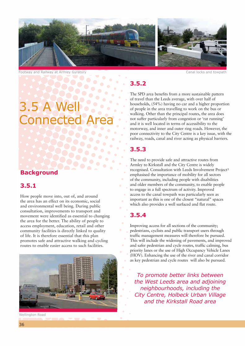
3.5.2
The SPD area benefits from a more sustainable pattern of travel than the Leeds average, with over half of households, (54%) having no car and a higher proportion of people in the area travelling to work on the bus or walking. Other than the principal routes, the area does not suffer particularly from congestion or ‘rat running’ and it is well located in terms of accessibility to the motorway, and inner and outer ring roads. However, the poor connectivity to the City Centre is a key issue, with the railway, roads, canal and river acting as physical barriers.
3.5.3
The need to provide safe and attractive routes from Armley to Kirkstall and the City Centre is widely recognised. Consultation with Leeds Involvement Project3 emphasised the importance of mobility for all sectors of the community, including people with disabilities and older members of the community, to enable people to engage in a full spectrum of activity. Improved access to the canal towpath was particularly seen as important as this is one of the closest “natural” spaces which also provides a well surfaced and flat route.
3.5.4
Improving access for all sections of the community; pedestrians, cyclists and public transport users through traffic management measures will therefore be pursued. This will include the widening of pavements, and improved and safer pedestrian and cycle routes, traffic calming, bus priority lanes or the use of High Occupancy Vehicle Lanes (HOV). Enhancing the use of the river and canal corridor as key pedestrian and cycle routes will also be pursued.
Background
3.5.1
How people move into, out of, and around the area has an effect on its economic, social and environmental well being. During public consultation, improvements to transport and movement were identified as essential to changing the area for the better. The ability of people to access employment, education, retail and other community facilities is directly linked to quality of life. It is therefore essential that this plan promotes safe and attractive walking and cycling routes to enable easier access to such facilities.
3.5 A Well Connected Area
Footway and Railway at Armley Gyratory Canal locks and towpath
Wellington Road
To promote better links between the West Leeds area and adjoining
neighbourhoods, including the City Centre, Holbeck Urban Village
and the Kirkstall Road area

37
Public Transport
Bus Transport
3.5.5
Public Transport to and from the area is considered to be good with landmark schemes like the FTR (FTR = future) bus route providing a frequent service both into the City Centre and out to West Leeds. This service in particular has also attracted local authority investment in highway improvements, including new bus stops and the Wellington Road bus lane.
3.5.6
Support is given for a number of improvements to transport infrastructure in the West Yorkshire Local Transport Plan 2 (LTP2) - West Yorkshire's strategic transport planning alliance between METRO and the 5 West Yorkshire District Councils. Schemes provisionally allocated funding include:
Carriageway/footway Improvements to Tong/Road Wellington Road corridor
A647 Quality Bus Initiative (Programmed)
Phase 1 – Bus Priority Measures – Construction due to start April 09
Phase 2 – Armley Road High Occupancy Vehicle Priority Lane (between ‘Mike’s Carpets’ and the Gyratory) – currently on hold pending the identification of funding
Potential schemes to be brought forward:
Copley Hill / Oldfield Lane / Tong Road Junction signalisation
LEED
S B
RAD
FORD
CO
RRID
OR
BRADFORD
LEEDSCITY
CENTRE
KIRKSTALL ROAD RENAISSANCE AREA
CARDIGAN FIELDS LEISURE PARKArmley
MillsMuseum
Armley
WORTLEY
LaneCentre
NewWortley
BEESTON HILL & HOLBECK
REGENERATION AREA
WI
TH
I N&
A R O U N D W E S T L E E D SG A T E
W
AY
RIVER & CANAL CORRIDOR
Diagram 8: Connectivity

38
Rail Transport
3.5.7
Armley has previously been identified as a possible location for a new rail halt in the Passenger Transport Executive’s Rail Plan 5. However this option was not identified as a priority in Rail Plan 6 – which covers the life of the LTP 2 (2006-2011) and a site has yet to be identified. There are inherent physical and other site constraints to be overcome before a rail halt in Armley can be realised, including signalling and timetabling issues. However as part of a longer term vision to provide an alternative to private car use beyond the life of the LTP 2, work should continue to identify a suitable site for a rail halt in Armley ensuring that:
It is well sited in relation to the local population
Accessibility requirements are met
The new halt does not adversely affect the existing train service in terms of signalling, timetabling or passenger comfort (crowding).
3.5.8
The two Leeds to Bradford rail links are being examined as part of a Leeds-Bradford corridor study: the Calderdale Line and Airedale line. The study will examine the possibility of separating express and stopping traffic on these two lines. This may have the effect of allowing greater flexibility in the timetabling between Leeds and Bradford on the Airedale line where a train station for Armley may be located. The City Council will maintain partnership work with the Department for Transport, Metro and Bradford Council to conclude this feasibility work.
WL 9The City Council will maintain partnership work with the Department for Transport, Metro and Bradford Council to further investigate the feasibility of delivering improved connectivity on the rail network between Leeds and Bradford to benefit local communities.
Pedestrian and Cycle Access
The River Aire and Leeds Liverpool Canal Corridor
3.5.9
This corridor is important as a level and well surfaced route which can be enjoyed by all sectors of the community. It is already well used as a cycling and walking route (the canal towpath is a National Cycle Network route). However, there is clearly an opportunity to promote the canal as a key pedestrian and cycle artery to the City Centre and to the West Leeds Country Park as it is a level well surfaced route which is suitable for people of all abilities. The aim is to facilitate easier level access to the canal from the SPD area and avoid developments which may impede this. In particular, the opportunity will be taken to strengthen the link from Armley Mills and Cardigan Fields Leisure Complex onto the canal towpath as part of any redevelopment proposals.
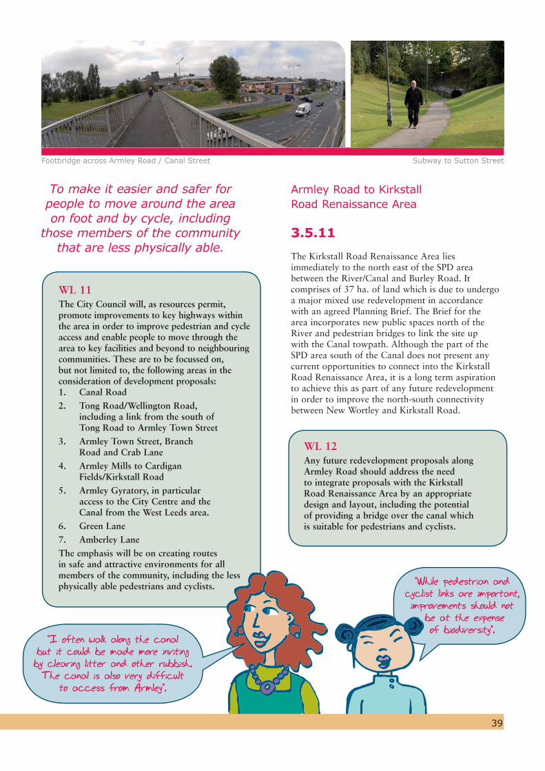
WL 10The City Council will, in partnership with British Waterways, promote the use of the canal as a pedestrian and cycle route, linking West Leeds to the City Centre and the West Leeds Country Park. Safety, environmental and access improvements will be promoted to ensure that the route will be accessible for all members of the community, including the less physically able.
3.5.10
In addition to the main east-west artery of the canal towpath and linked routes, the provision of safe and accessible walking and cycling routes throughout the area will promote more active and healthy lifestyles and reduce reliance on the car. These links are identified on Diagram 7 (Greenspace and Green Links Plan). The Council is committed to improving the Public Rights of Way network district wide and has adopted a Rights of Way Improvement Plan which includes a programme to complete the Definitive Map for Leeds, the legal record of Public Rights of Way.
“Improved access to the canal towpath is a major issue, particularly for the disabled”.
Armley Road to Kirkstall Road Renaissance Area
3.5.11
The Kirkstall Road Renaissance Area lies immediately to the north east of the SPD area between the River/Canal and Burley Road. It comprises of 37 ha. of land which is due to undergo a major mixed use redevelopment in accordance with an agreed Planning Brief. The Brief for the area incorporates new public spaces north of the River and pedestrian bridges to link the site up with the Canal towpath. Although the part of the SPD area south of the Canal does not present any current opportunities to connect into the Kirkstall Road Renaissance Area, it is a long term aspiration to achieve this as part of any future redevelopment in order to improve the north-south connectivity between New Wortley and Kirkstall Road.
WL 12Any future redevelopment proposals along Armley Road should address the need to integrate proposals with the Kirkstall Road Renaissance Area by an appropriate design and layout, including the potential of providing a bridge over the canal which is suitable for pedestrians and cyclists.
WL 11The City Council will, as resources permit, promote improvements to key highways within the area in order to improve pedestrian and cycle access and enable people to move through the area to key facilities and beyond to neighbouring communities. These are to be focussed on, but not limited to, the following areas in the consideration of development proposals:1. Canal Road2. Tong Road/Wellington Road,
including a link from the south of Tong Road to Armley Town Street
3. Armley Town Street, Branch Road and Crab Lane
4. Armley Mills to Cardigan Fields/Kirkstall Road
5. Armley Gyratory, in particular access to the City Centre and the Canal from the West Leeds area.
6. Green Lane7. Amberley LaneThe emphasis will be on creating routes in safe and attractive environments for all members of the community, including the less physically able pedestrians and cyclists.
Footbridge across Armley Road / Canal Street Subway to Sutton Street
“While pedestrian and cyclist links are important, improvements should not be at the expense
of biodiversity”.
To make it easier and safer for people to move around the area on foot and by cycle, including
those members of the community that are less physically able.
“I often walk along the canal but it could be made more inviting by clearing litter and other rubbish. The canal is also very difficult
to access from Armley”.
39
40
Car Parking – Armley Town Centre
3.5.14
An appropriate balance needs to be struck between vehicle users and those travelling by foot, bus and cycle in order to create attractive, lively, safe and interesting places. This does not mean excluding the car. Vehicular access and parking within Armley Town Centre is a key issue for traders and it is recognised that additional short stay parking and improved directional signing is required to support the town centre and local businesses (see para. 3.6.10).
Developer Contributions – Public Transport
3.5.15
Developers will be expected to contribute to improved physical infrastructure and improved public transport services. Any development proposal will therefore be assessed in accordance with the guidance contained within the City Council’s SPD “Public Transport Improvements and Developer Contributions,” August 2008. This assessment will establish whether or not a developer contribution will be required to secure enhancements to public transport infrastructure in order to help address the travel impact of the proposed development.
3.5.16 Development proposals also need to include a Travel Plan prepared in accordance with the guidance contained within the City Council’s draft SPD “Travel Plans”, May 2007 (adopted for development control purposes from 1st June 2007 onwards).
Armley Road/New Wortley
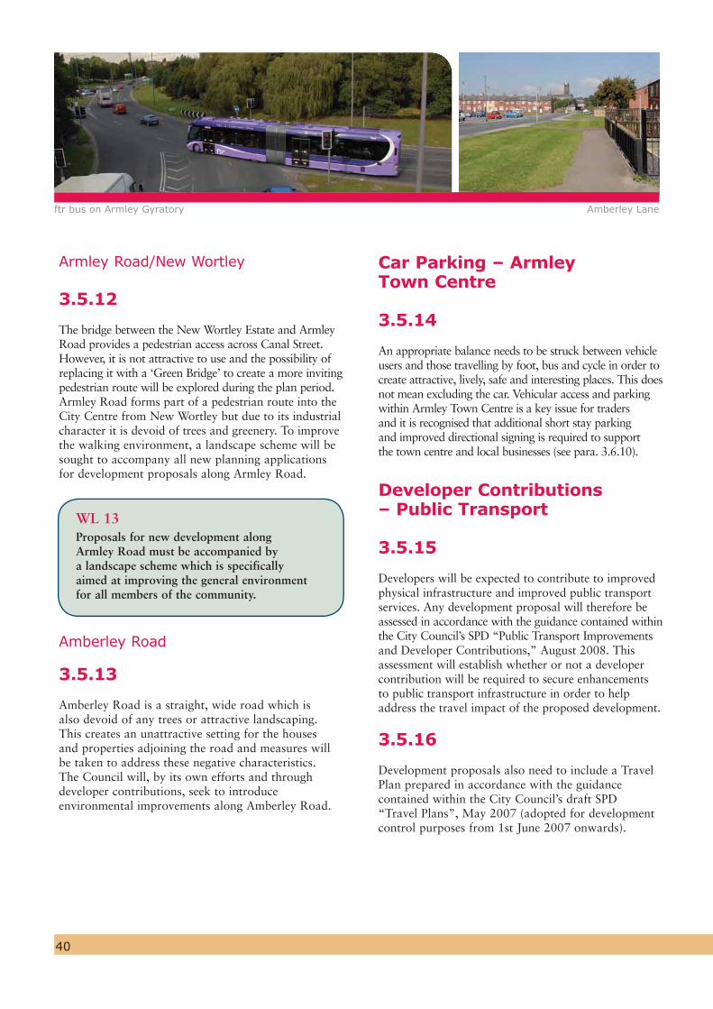
3.5.12
The bridge between the New Wortley Estate and Armley Road provides a pedestrian access across Canal Street. However, it is not attractive to use and the possibility of replacing it with a ‘Green Bridge’ to create a more inviting pedestrian route will be explored during the plan period. Armley Road forms part of a pedestrian route into the City Centre from New Wortley but due to its industrial character it is devoid of trees and greenery. To improve the walking environment, a landscape scheme will be sought to accompany all new planning applications for development proposals along Armley Road.
WL 13Proposals for new development along Armley Road must be accompanied by a landscape scheme which is specifically aimed at improving the general environment for all members of the community.
Amberley Road
3.5.13
Amberley Road is a straight, wide road which is also devoid of any trees or attractive landscaping. This creates an unattractive setting for the houses and properties adjoining the road and measures will be taken to address these negative characteristics. The Council will, by its own efforts and through developer contributions, seek to introduce environmental improvements along Amberley Road.
ftr bus on Armley Gyratory Amberley Lane
41
Armley Gyratory
“Linkages to the city centre for pedestrians and cyclists via the gyratory need significant improvements as presently it is a very unattractive and unsafe route”.
Armley Gyratory
3.5.17
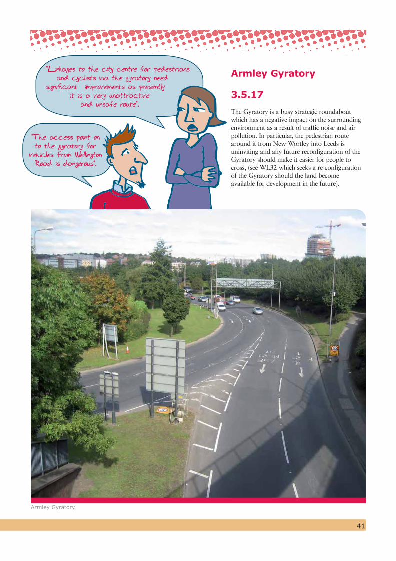
The Gyratory is a busy strategic roundabout which has a negative impact on the surrounding environment as a result of traffic noise and air pollution. In particular, the pedestrian route around it from New Wortley into Leeds is uninviting and any future reconfiguration of the Gyratory should make it easier for people to cross, (see WL32 which seeks a re-configuration of the Gyratory should the land become available for development in the future).
“The access point on to the gyratory for
vehicles from Wellington Road is dangerous”.
Armley Town Centre
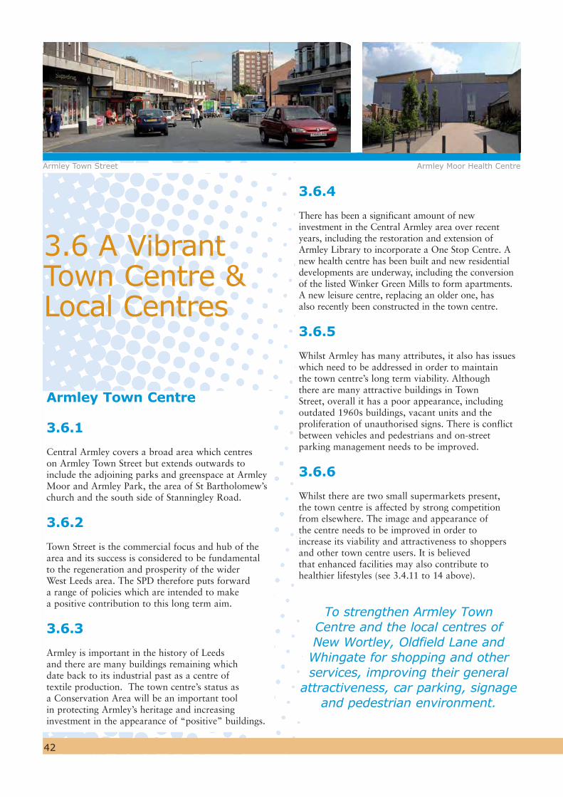
3.6.1
Central Armley covers a broad area which centres on Armley Town Street but extends outwards to include the adjoining parks and greenspace at Armley Moor and Armley Park, the area of St Bartholomew’s church and the south side of Stanningley Road.
3.6.2
Town Street is the commercial focus and hub of the area and its success is considered to be fundamental to the regeneration and prosperity of the wider West Leeds area. The SPD therefore puts forward a range of policies which are intended to make a positive contribution to this long term aim.
3.6.3
Armley is important in the history of Leeds and there are many buildings remaining which date back to its industrial past as a centre of textile production. The town centre’s status as a Conservation Area will be an important tool in protecting Armley’s heritage and increasing investment in the appearance of “positive” buildings.
42
3.6.4
There has been a significant amount of new investment in the Central Armley area over recent years, including the restoration and extension of Armley Library to incorporate a One Stop Centre. A new health centre has been built and new residential developments are underway, including the conversion of the listed Winker Green Mills to form apartments. A new leisure centre, replacing an older one, has also recently been constructed in the town centre.
3.6.5
Whilst Armley has many attributes, it also has issues which need to be addressed in order to maintain the town centre’s long term viability. Although there are many attractive buildings in Town Street, overall it has a poor appearance, including outdated 1960s buildings, vacant units and the proliferation of unauthorised signs. There is conflict between vehicles and pedestrians and on-street parking management needs to be improved.
3.6.6
Whilst there are two small supermarkets present, the town centre is affected by strong competition from elsewhere. The image and appearance of the centre needs to be improved in order to increase its viability and attractiveness to shoppers and other town centre users. It is believed that enhanced facilities may also contribute to healthier lifestyles (see 3.4.11 to 14 above).
3.6 A Vibrant Town Centre & Local Centres
Armley Town Street Armley Moor Health Centre
To strengthen Armley Town Centre and the local centres of New Wortley, Oldfield Lane and
Whingate for shopping and other services, improving their general
attractiveness, car parking, signage and pedestrian environment.

43
3.6.7
Saved Policy S2 of the adopted UDP seeks to protect the vitality and viability of the town centres, including Armley, and the City Council will continue to control and steer development to in-centre locations, consistent with national planning policy (Planning Policy Statement 4). A key objective is to ensure that Armley fulfils its true potential and remains the principal location for retail and other appropriate town centre services for local residents.
Town Centre Boundary
3.6.8
Although the former leisure centre was located within the town centre, its replacement has been built on a site which currently falls just outside of the town centre boundary. It would therefore be appropriate to redraw the town centre boundary, to reflect this recent development.
3.6.9
The Armley One Stop Centre also lies just outside the designated town centre boundary. To reflect its important role within the town centre, it is logical to revise the boundary from that shown in the UDP, to include the building within the town centre area. It is proposed that this change will be incorporated into Leeds' Site Allocations Development Plan Document, which will replace/update the land use allocations in the current Unitary Development Plan.
WL 14The town centre boundary should be extended to include the area of the new leisure centre and the One Stop Centre, defined on the SPD Plan.
Diagram 9: Proposed extensions to Armley Town Centre
© Crown Copyright. All rights reserved. Leeds City Council O.S. Licence No. - 100019567. 2010
Arm

44
Traffic Management and Parking
3.6.10
The existing arrangements for on-street parking in the town centre area has led to a large amount of long stay and all-day parking on adjoining streets, which impacts on shoppers. It is recognised that better management of parking, including designated short stay parking, would encourage greater usage of the shopping and other facilities in addition to improving pedestrian safety. Although there are very limited opportunities to provide additional off-street parking in the town centre, the new leisure centre provides additional car parking which will be available for town centre users. In addition, the site at Gelder Road (see WL 16) may also have potential for additional short stay parking.
Town Centre Improvement
3.6.11
It is considered that Armley Town Centre lacks an overall ‘look’ in terms of shopping frontages, street furniture, signage and surface treatment. Parking areas are generally poorly marked out and there is a clutter of highway signage. The City Council has therefore programmed improvements to Armley Town Centre through the ‘Town and District Centre Regeneration Scheme’ in order to improve public areas and the street scene. This is designed to make visits to the town centre a more pleasant experience and help to underpin its commercial success. This work is to include resurfacing the pavements in Yorkstone, replacing the existing street furniture with new heritage-style railings, seating and lighting columns and introducing public art. It is hoped that individual property owners will support this initiative by bringing forward improvement schemes for their business premises.
WL 15The City Council will improve the visual and general environment of the town centre by implementing an improvement scheme by the end of 2010 which will include the following work:
- Resurfacing of footpaths and kerbs from Armley One Stop Centre to Armley Moor in Yorkstone and granite
- Install black heritage-style lighting columns- Re-paint the cctv masts in black to
match the new street lighting- Introducing matching heritage-style street
furniture, in black; steel benches, litter bins, cycle racks and pedestrian guards
- Introduce artwork to include a historic timeline, in the form of a series of 14 keystones at intervals on town street, noting historic events and people, a compass in stone and granite depicting distances and directions to towns and cities around the world.
Beyond 2010, the council will, in partnership with the local business community and others, continue to support improvements to the town centre which will help to maintain its viability and attractiveness.
“Need to improve car parking around Armley Town Street in order to support local businesses”.
Armley Town Street looking East

45
3.6.12 Gelder Road to the north of Town Street is bordered by a terrace of small retail units. The units have a poor appearance and suffer from low occupancy. Whilst retailing uses would be acceptable, given their location to the rear of the main shopping area, it is considered that this area may be better suited to managed workshop units, offices or even car parking.
WL 16The council will encourage the refurbishment or redevelopment of the Gelder Road commercial units for either retail, leisure, office or workspace for small businesess or start up units. The site is also suitable as a car park to serve the town centre.
3.6.13
The town centre is adjoined by a large resident population and pedestrian and cycle access will be encouraged both within and from outside
the centre through the provision of safe, convenient and attractive links (See WL 11).
3.6.14
Armley Moor is located immediately on the edge of the town centre but its potential as a recreational area and an important pedestrian route is not fully realised. The site has therefore been prioritised for improvement under WL 4 in order to make it a distinguishing feature of Armley town centre and a space that people will find attractive to use.
3.6.15
The City Council has successfully applied to the Heritage Lottery for funding under the Townscape Heritage Initiative Scheme (THI) following designation of the Conservation Area in central Armley. Grant aid will be made available to owners of historic property on Branch Road and Town Street to carry out appropriate repairs, reinstatement and work to bring vacant space back into use. The THI will also match fund the public realm improvements which are programmed to be completed in 2010, ensuring that high quality natural materials are used.
Illustration of Branch Road Gateway

46
3.6.16
One of the priorities for improvement is No.2 Branch Road, (known locally as Mike’s Carpets). This is a former chapel and a Grade II Listed Building which lies in a prominent gateway location at the junction of Branch Road and Stanningley Road. The building suffers from unsightly unauthorised signage and its fabric is in a poor state. The building therefore needs significant investment and an alternative use would ensure a sustainable future for the building and create a positive entrance to Armley Town Centre.
WL 17Number 2 Branch Road, a listed Grade II former chapel, occupies a prominent gateway position to Armley Town Centre. The City Council will take action to remove unauthorised signage and work towards securing an alternative use which would ensure a sustainable future for this important building.
Local Centres
3.6.17
Three local centres fall within the SPD area: Oldfield Lane, New Wortley and Whingate. These local centres are vital in being able to offer easily accessible day-to-day shopping and other community facilities to meet resident’s needs. As the centres are located at the heart of the communities they serve, they are the most sustainable means of grouping and accessing shopping and local services. The centres are shown on the SPD Plan and are intended to be formally carried forward into the proposed Site Allocations Development Plan Document.
Oldfield Lane Local Centre
3.6.18
The Local Centre consists of a supermarket, associated smaller stores and car park, together with three shops located close to the junction of Oldfield Lane and Amberley Road.
Mike's Carpets, Branch Road
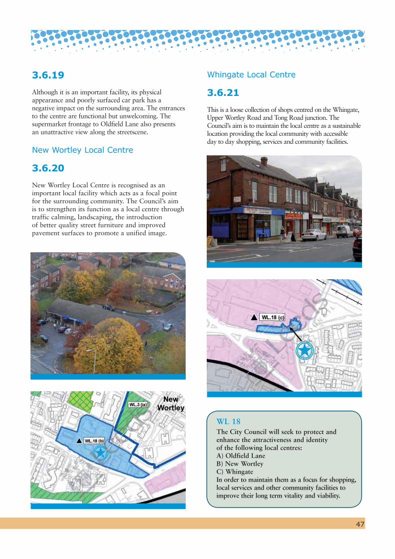
Whingate Local Centre
3.6.21
This is a loose collection of shops centred on the Whingate, Upper Wortley Road and Tong Road junction. The Council’s aim is to maintain the local centre as a sustainable location providing the local community with accessible day to day shopping, services and community facilities.
WL 18The City Council will seek to protect and enhance the attractiveness and identity of the following local centres:A) Oldfield LaneB) New WortleyC) WhingateIn order to maintain them as a focus for shopping, local services and other community facilities to improve their long term vitality and viability.
3.6.19
Although it is an important facility, its physical appearance and poorly surfaced car park has a negative impact on the surrounding area. The entrances to the centre are functional but unwelcoming. The supermarket frontage to Oldfield Lane also presents an unattractive view along the streetscene.
New Wortley Local Centre
3.6.20
New Wortley Local Centre is recognised as an important local facility which acts as a focal point for the surrounding community. The Council’s aim is to strengthen its function as a local centre through traffic calming, landscaping, the introduction of better quality street furniture and improved pavement surfaces to promote a unified image.
47

Land Suitable for Housing
3.7.1
The context for housing land release is contained in the adopted UDP Review (2006). The key approach in the UDP is that new housing development should focus on the reuse of previously developed sites (brownfield land) and the regeneration of the urban area. The West Leeds Gateway clearly falls into the category where housing development of the right quality will contribute to such an urban renaissance in a sustainable location close to the City Centre.
3.7.2
The SPD identifies a number of sites which would be suitable for housing and which are described below. In line with the UDP, priority is given to re-using previously developed land. Although the SPD cannot allocate land, it is intended that the approach set out in this SPD will inform the Leeds' Site Allocations Development Plan Document (DPD) which will replace/update the land use allocations in the current Unitary Development Plan. Prior to the adoption of the Site AllocationsDPD, the Council would be minded to support planning
48
applications which are in conformity with this SPD and saved policies in the UDP Review.
3.7.3
In addition to promoting sites for new housing, West North West Homes is embarking on a major programme of housing improvement work on the New Wortley estate in order to bring homes up to the required ‘decency standard’. This work has now commenced and once completed will have a positive impact upon the quality and energy efficiency of the existing housing stock.
3.7.4
The Council is also looking at options for the improvement of older private housing stock in the area. This will include group repair and face-lift schemes to improve the external fabric of properties, gardens and yards. Currently the options are being considered with a view to making an initial bid to Leeds City Region in 2010 for funding from 2011 onwards. If successful it is hoped that this would be the first round of a number of bids to allow the continual long term improvement of the older private stock in West Leeds as part of the comprehensive approach to the regeneration of the area.
3.7 An Attractive Place to Live and Work
View of The Heights from Farnley Laurel Terrace / Brentwood Terrace
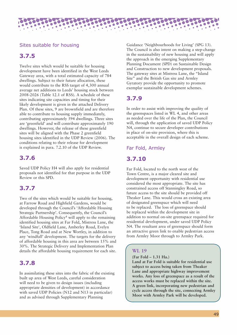
49
Sites suitable for housing
3.7.5
Twelve sites which would be suitable for housing development have been identified in the West Leeds Gateway area, with a total estimated capacity of 784 dwellings. Subject to their future allocation, these would contribute to the RSS target of 4,300 annual average net additions to Leeds’ housing stock between 2008-2026 (Table 12.1 of RSS). A schedule of these sites indicating site capacities and timing for their likely development is given in the attached Delivery Plan. Of these sites, 9 are brownfield and are therefore able to contribute to housing supply immediately, contributing approximately 594 dwellings. Three sites are ‘greenfield’ and will contribute approximately 190 dwellings. However, the release of these greenfield sites will be aligned with the Phase 2 greenfield housing sites identified in the UDP Review (2006). The conditions relating to their release for development is explained in para. 7.2.10 of the UDP Review.
3.7.6
Saved UDP Policy H4 will also apply for residentialproposals not identified for that purpose in the UDPReview or this SPD.
3.7.7
Two of the sites which would be suitable for housing, at Farrow Road and Highfield Gardens, would be developed through the Council’s ‘Affordable Housing Strategic Partnership’. Consequently, the Council’s Affordable Housing Policy4 will apply to the remaining identified housing sites at Far Fold, Mistress Lane, the ‘Island Site', Oldfield Lane, Amberley Road, Evelyn Place, Tong Road and at New Wortley, in addition to any ‘windfall’ development. The targets for the delivery of affordable housing in this area are between 15% and 30%. The Strategic Delivery and Implementation Plan details the affordable housing requirement for each site.
3.7.8
In assimilating these sites into the fabric of the existing built up area of West Leeds, careful consideration will need to be given to design issues (including appropriate densities of development) in accordance with saved UDP Policies (N12 and N13 in particular) and as advised through Supplementary Planning
Guidance ‘Neighbourhoods for Living’ (SPG 13). The Council is also intent on making a step-change in the sustainability of new housing and will apply the approach in the emerging Supplementary Planning Document (SPD) on Sustainable Design and Construction to new development proposals. The gateway sites at Mistress Lane, the “Island Site” and the British Gas site and Armley Gyratory provide the opportunity to promote exemplar sustainable development schemes.
3.7.9
In order to assist with improving the quality of the greenspaces listed in WL 4, and other areas as needed over the life of the Plan, the Council will, through the application of saved UDP Policy N4, continue to secure developer contributions in place of on-site provision, where this is acceptable in the overall design of each scheme.
Far Fold, Armley
3.7.10
Far Fold, located to the north west of the Town Centre, is a major cleared site and development opportunity with residential use considered the most appropriate. The site has constrained access off Stanningley Road, so future access to the site should be provided off Theaker Lane. This would cross an existing area of designated greenspace which will needto be replaced. The loss of greenspace should be replaced within the development site inaddition to normal on-site greenspace required for residential development, under saved UDP Policy N4. The resultant area of greenspace should form an attractive green link to enable pedestrian access from Armley Moor through to Armley Park.
WL 19 (Far Fold – 1.31 Ha.)Land at Far Fold is suitable for residential use subject to access being taken from Theaker Lane and appropriate highway improvement works. Any loss of greenspace as a result of the access works must be replaced within the site. A green link, incorporating new pedestrian and cycle access through the site, connecting Armley Moor with Armley Park will be developed.

50
an opportunity to create an attractive pedestrian route towards Armley Mills. It is envisaged that the predominant use will be residential. Given that it will be difficult to provide useable on-site greenspace on this site, a commuted sum in lieu of on-site provision, would be acceptable in order to enable the Council to invest this in raising the quality of nearby greenspaces.
WL 21
(The ‘Island Site’ – 0.86 Ha.)The City Council will prepare a planning brief for ‘the Island Site’ in order to promote a comprehensive and high quality development for this gateway site, which is regarded as suitable for predominantly residential use.
Oldfield Lane
3.7.13
Just to the east of the existing supermarket and to the north of Oldfield Lane is a disused playing field which is partly owned by Leeds Schools Sports Association (LSSA) and partly by the City Council. This site has been disused for several years as it was no longer ‘fit for purpose’ for the LSSA to use for exhibition matches and as the home of Leeds City Boys. The pitch has never been in general community use and retaining this single pitch is not consistent with the Council’s strategy for playing pitches. The site is now being made available for housing development. This proposal is on the basis that the developer would need to replace the pitch elsewhere within Leeds and fund improvements to the playing pitches at the nearby Wortley Recreation Ground in order to raise their quality and playability.
Mistress Lane, Armley
3.7.11
The Mistress Lane development site is owned by the City Council. It is located at the entrance to the Town Centre in a prominent position. The site lies adjacent to two tower blocks, Westerly Croft and Westerly Rise. Redevelopment schemes for the site must provide 40 car spaces for these retained flats. In bringing forward a development scheme, the opportunity should be taken to improve the visual attributes of the tower blocks and create a strong frontage to Armley Road and Crab Lane, producing a striking but sympathetic building which wraps around this prominent corner site. Development on the Mistress Lane frontage should be lower scale and more in keeping with existing residential properties. Given that it will be difficult to provide useable on-site greenspace on this site, a commuted sum in lieu of on-site provision would be acceptable in order to enable the Council to invest this in raising the quality of nearby greenspaces.
WL 20 (Mistress Lane – 1.19 ha)Mistress Lane is suitable for residential use. Redevelopment of this gateway site is expected to retain the two existing tower blocks and be designed to create a prominent frontage to Armley Road and Crab Lane as well as respect the character of Mistress Lane.
The ‘Island’ site
3.7.12
To the south of Canal Road the City Council has identified a site which presently detracts from the streetscene, but which has the potential to offer major improvements of benefit to the wider area if it is developed in an appropriate manner. The site incorporates two public houses and a historic lifting tower which have architectural merit and contribute positively to the area. However, to the rear of these are a number of buildings that are vacant and in a poor state of repair. The City Council believes that a comprehensive redevelopment of the whole site, while maintaining the positive features referred to, would greatly enhance the character of the area and provide Mistress Lane Site
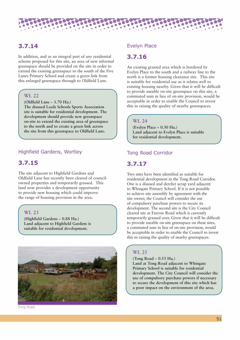
51
Evelyn Place
3.7.16
An existing grassed area which is bordered by Evelyn Place to the south and a railway line to the north is a former housing clearance site. This site is suitable for residential use as it relates well to existing housing nearby. Given that it will be difficult to provide useable on-site greenspace on this site, a commuted sum in lieu of on-site provision, would be acceptable in order to enable the Council to invest this in raising the quality of nearby greenspaces.
WL 24(Evelyn Place – 0.30 Ha.)Land adjacent to Evelyn Place is suitable for residential development.
Tong Road Corridor
3.7.17
Two sites have been identified as suitable for residential development in the Tong Road Corridor. One is a disused and derelict scrap yard adjacent to Whingate Primary School. If it is not possible to achieve site assembly by agreement with the site owner, the Council will consider the use of compulsory purchase powers to secure its development. The second site is the City Council cleared site at Farrow Road which is currently temporarily grassed over. Given that it will be difficult to provide useable on-site greenspace on these sites, a commuted sum in lieu of on-site provision, would be acceptable in order to enable the Council to invest this in raising the quality of nearby greenspaces.
WL 25
(Tong Road – 0.53 Ha.)Land at Tong Road adjacent to Whingate Primary School is suitable for residential development. The City Council will consider the use of compulsory purchase powers if necessary to secure the development of this site which has a poor impact on the environment of the area.
3.7.14
In addition, and as an integral part of any residential scheme proposed for this site, an area of new informal greenspace should be provided on the site in order to extend the existing greenspace to the south of the Five Lanes Primary School and create a green link from this enlarged greenspace through to Oldfield Lane.
WL 22
(Oldfield Lane – 1.70 Ha.)The disused Leeds Schools Sports Association site is suitable for residential development. The development should provide new greenspace on-site to extend the existing area of greenspace to the north and to create a green link across the site from this greenspace to Oldfield Lane.
Highfield Gardens, Wortley
3.7.15
The site adjacent to Highfield Gardens and Oldfield Lane has recently been cleared of council-owned properties and temporarily grassed. This land now provides a development opportunity to provide new housing which could improve the range of housing provision in the area.
WL 23
(Highfield Gardens – 0.88 Ha.)Land adjacent to Highfield Gardens is suitable for residential development.
Tong Road
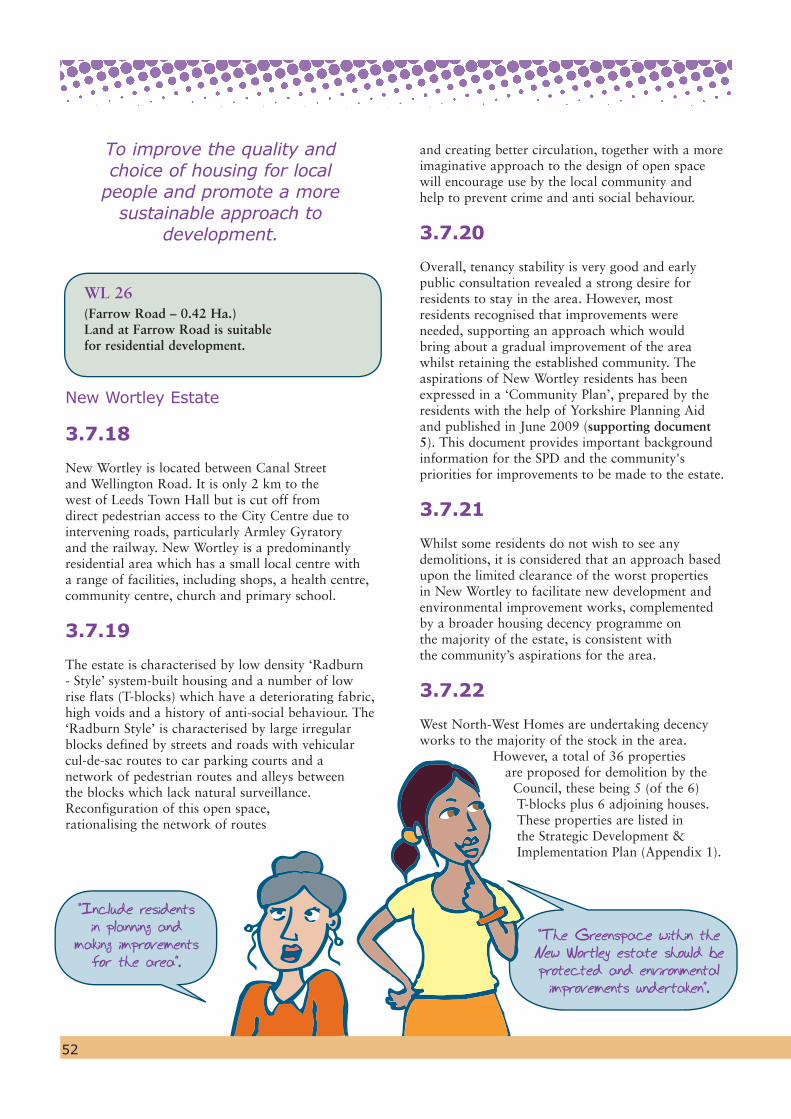
“Include residents in planning and
making improvements for the area”.
WL 26
(Farrow Road – 0.42 Ha.)Land at Farrow Road is suitable for residential development.
New Wortley Estate
3.7.18
New Wortley is located between Canal Street and Wellington Road. It is only 2 km to the west of Leeds Town Hall but is cut off from direct pedestrian access to the City Centre due to intervening roads, particularly Armley Gyratory and the railway. New Wortley is a predominantly residential area which has a small local centre with a range of facilities, including shops, a health centre, community centre, church and primary school.
3.7.19
The estate is characterised by low density ‘Radburn - Style’ system-built housing and a number of low rise flats (T-blocks) which have a deteriorating fabric, high voids and a history of anti-social behaviour. The ‘Radburn Style’ is characterised by large irregular blocks defined by streets and roads with vehicular cul-de-sac routes to car parking courts and a network of pedestrian routes and alleys between the blocks which lack natural surveillance. Reconfiguration of this open space, rationalising the network of routes
“The Greenspace within the New Wortley estate should be protected and environmental improvements undertaken”.
and creating better circulation, together with a more imaginative approach to the design of open space will encourage use by the local community and help to prevent crime and anti social behaviour.
3.7.20
Overall, tenancy stability is very good and early public consultation revealed a strong desire for residents to stay in the area. However, most residents recognised that improvements were needed, supporting an approach which would bring about a gradual improvement of the area whilst retaining the established community. The aspirations of New Wortley residents has been expressed in a ‘Community Plan’, prepared by the residents with the help of Yorkshire Planning Aid and published in June 2009 (supporting document 5). This document provides important background information for the SPD and the community's priorities for improvements to be made to the estate.
3.7.21
Whilst some residents do not wish to see any demolitions, it is considered that an approach based upon the limited clearance of the worst properties in New Wortley to facilitate new development and environmental improvement works, complemented by a broader housing decency programme on the majority of the estate, is consistent with the community’s aspirations for the area.
3.7.22
West North-West Homes are undertaking decency works to the majority of the stock in the area.
However, a total of 36 properties are proposed for demolition by the
Council, these being 5 (of the 6) T-blocks plus 6 adjoining houses. These properties are listed in the Strategic Development & Implementation Plan (Appendix 1).
52
To improve the quality and choice of housing for local
people and promote a more sustainable approach to
development.
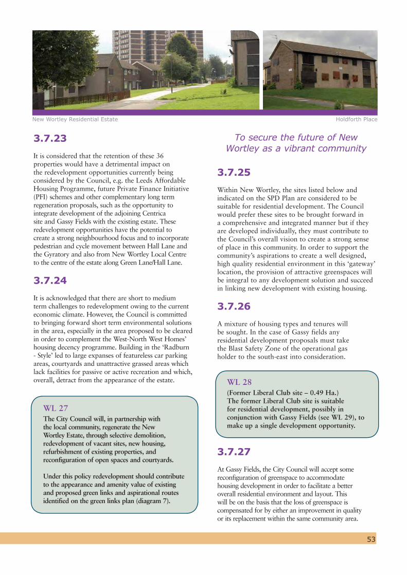
New Wortley Residential Estate Holdforth Place
53
3.7.23
It is considered that the retention of these 36 properties would have a detrimental impact on the redevelopment opportunities currently being considered by the Council, e.g. the Leeds Affordable Housing Programme, future Private Finance Initiative (PFI) schemes and other complementary long term regeneration proposals, such as the opportunity to integrate development of the adjoining Centrica site and Gassy Fields with the existing estate. These redevelopment opportunities have the potential to create a strong neighbourhood focus and to incorporate pedestrian and cycle movement between Hall Lane and the Gyratory and also from New Wortley Local Centre to the centre of the estate along Green Lane/Hall Lane.
3.7.24
It is acknowledged that there are short to medium term challenges to redevelopment owing to the current economic climate. However, the Council is committed to bringing forward short term environmental solutions in the area, especially in the area proposed to be cleared in order to complement the West-North West Homes’ housing decency programme. Building in the ‘Radburn - Style’ led to large expanses of featureless car parking areas, courtyards and unattractive grassed areas which lack facilities for passive or active recreation and which, overall, detract from the appearance of the estate.
WL 27The City Council will, in partnership with the local community, regenerate the New Wortley Estate, through selective demolition, redevelopment of vacant sites, new housing, refurbishment of existing properties, and reconfiguration of open spaces and courtyards.
Under this policy redevelopment should contribute to the appearance and amenity value of existing and proposed green links and aspirational routes identified on the green links plan (diagram 7).
3.7.25
Within New Wortley, the sites listed below and indicated on the SPD Plan are considered to be suitable for residential development. The Council would prefer these sites to be brought forward in a comprehensive and integrated manner but if they are developed individually, they must contribute to the Council’s overall vision to create a strong sense of place in this community. In order to support the community’s aspirations to create a well designed, high quality residential environment in this ‘gateway’ location, the provision of attractive greenspaces will be integral to any development solution and succeed in linking new development with existing housing.
3.7.26
A mixture of housing types and tenures will be sought. In the case of Gassy fields any residential development proposals must take the Blast Safety Zone of the operational gas holder to the south-east into consideration.
WL 28
(Former Liberal Club site – 0.49 Ha.) The former Liberal Club site is suitable for residential development, possibly in conjunction with Gassy Fields (see WL 29), to make up a single development opportunity.
3.7.27
At Gassy Fields, the City Council will accept some reconfiguration of greenspace to accommodate housing development in order to facilitate a better overall residential environment and layout. This will be on the basis that the loss of greenspace is compensated for by either an improvement in quality or its replacement within the same community area.
To secure the future of New Wortley as a vibrant community
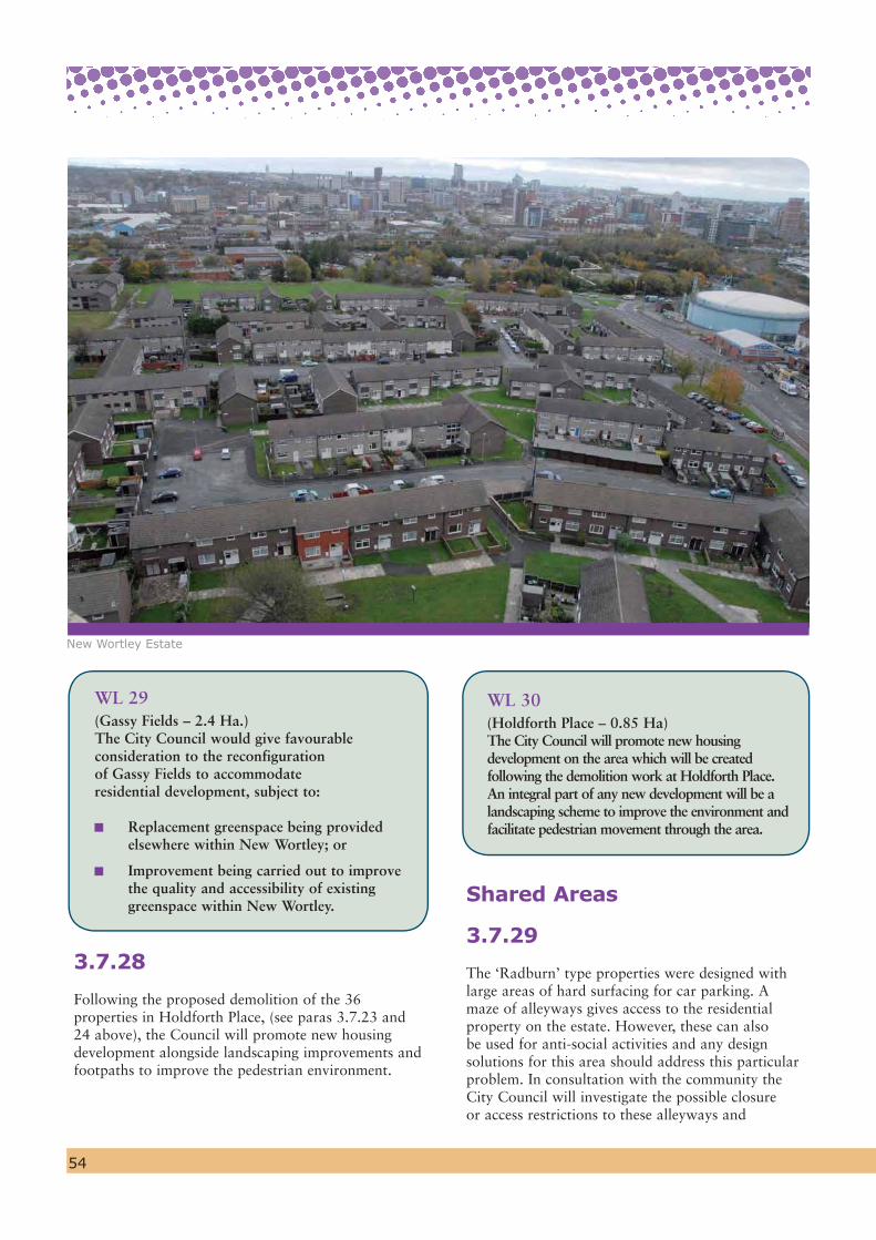
54
WL 29
(Gassy Fields – 2.4 Ha.)The City Council would give favourable consideration to the reconfiguration of Gassy Fields to accommodate residential development, subject to:
Replacement greenspace being provided elsewhere within New Wortley; or
Improvement being carried out to improve the quality and accessibility of existing greenspace within New Wortley.
3.7.28
Following the proposed demolition of the 36 properties in Holdforth Place, (see paras 3.7.23 and 24 above), the Council will promote new housing development alongside landscaping improvements and footpaths to improve the pedestrian environment.
WL 30 (Holdforth Place – 0.85 Ha)The City Council will promote new housing development on the area which will be created following the demolition work at Holdforth Place. An integral part of any new development will be a landscaping scheme to improve the environment and facilitate pedestrian movement through the area.
Shared Areas
3.7.29
The ‘Radburn’ type properties were designed with large areas of hard surfacing for car parking. A maze of alleyways gives access to the residential property on the estate. However, these can also be used for anti-social activities and any design solutions for this area should address this particular problem. In consultation with the community the City Council will investigate the possible closure or access restrictions to these alleyways and
New Wortley Estate

55
City Centre for pedestrians and cyclists. Vehicles accessing the junction from Tong Road in the peak hours also have significant difficulties.
3.7.33
Therefore, any future development of the Training Centre and Gyratory site would have to address these issues. The clear objective is to find a more efficient highway layout that improves connectivity between New Wortley and the City Centre and provides a convenient, accessible and safe route for pedestrians and cyclists. The opportunity to connect into the planned ‘green viaduct’ (a proposed high level pedestrian route), which runs from the eastern side of the Gyratory into Holbeck Urban Village should also be considered as part of any planned improvement.
3.7.34
The City Council will therefore work in conjunction with the landowner to overcome site constraints and guide future alternative uses of the sites should they become available for development.
WL 32The City Council will support the redevelopment of the Training Centre site, (Canal Street) and the Gyratory as a gateway development for a mix of uses to include residential and employment which;
Promotes the strategic location as a gateway site to the West Leeds area
Is of a high quality design which respects the scale of surrounding development
Improves links for pedestrians and cyclists between New Wortley and the City Centre by providing accessible, safe and logical routes through the site.
Provides high quality useable greenspaces which are designed to integrate new development with existing houses
Contributes to the Councils’ aim of improving the existing gyratory system with a more efficient highway layout that also reduces the barriers to pedestrian accessibility between West Leeds and the City Centre.
carry out environmental improvements in the form of ‘Shared Areas’, i.e. shared surfaced areas for car parking, walking and cycling, landscaping and play.
WL 31The City Council will consult with the local community to develop a network of shared areas and courtyards to ensure appropriate parking provision and an improved environment. Consideration will also be given to the closure of, or restricting access to, the alleyways within the New Wortley estate.
Training Centre, Canal Street
3.7.30
The Training Centre, located adjacent to Canal Street with its associated car parking on the Gyratory, is a significant employer within the area. However, it is anticipated that the training centre may be relocated during the life of the plan. In such circumstances it is considered that the site could be successfully developed for a mix of uses, with individual uses being configured within the site to ensure that they would be compatible with existing neighbouring uses in and around the New Wortley estate.
3.7.31
The location of the site is strategically important and presents an opportunity to create a ‘Gateway’ development at the entrance to the West Leeds area. High quality design is therefore of paramount importance, as is the need to respect the scale of existing development nearby. Any new development would also need to provide accessible and safe routes for pedestrians and cyclists through the site to improve links between New Wortley and the City Centre.
Armley Gyratory
3.7.32
The Armley Gyratory is a key junction linking the motorway network to Leeds City Centre. It currently experiences significant peak hour queuing, causing congestion, delay and related air quality problems. It also has a poor accident history. The Gyratory is also a major physical barrier between West Leeds and the
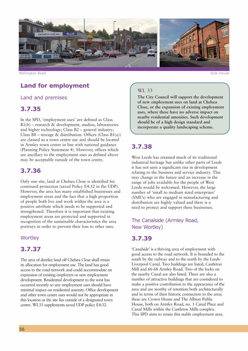
56
Land for employment
Land and premises
3.7.35
In the SPD, ‘employment uses’ are defined as Class B1(b) – research & development, studios, laboratories and higher technology; Class B2 – general industry; Class B8 – storage & distribution. Offices (Class B1(a)) are classed as a town centre use and should be located in Armley town centre in line with national guidance (Planning Policy Statement 4). However, offices which are ancillary to the employment uses as defined above may be acceptable outside of the town centre.
3.7.36
Only one site, land at Chelsea Close is identified for continued protection (saved Policy E4:32 in the UDP). However, the area has many established businesses and employment areas and the fact that a high proportion of people both live and work within the area is a positive attribute which needs to be supported and strengthened. Therefore it is important that existing employment areas are protected and supported in recognition of the sustainable characteristics the area portrays in order to prevent their loss to other uses.
Wortley
3.7.37
The area of derelict land off Chelsea Close shall retain its allocation for employment use. The land has good access to the road network and could accommodate an expansion of existing employers or new employment development. Residential development to the west has occurred recently so any employment uses should have minimal impact on residential amenity. Office development and other town centre uses would not be appropriate in this location as the site lies outside of a designated town centre. WL33 supplements saved UDP policy E4:32.
WL 33The City Council will support the development of new employment uses on land at Chelsea Close, or the expansion of existing employment uses, where these have no adverse impact on nearby residential amenities. Such development should be of a high design standard and incorporate a quality landscaping scheme.
3.7.38
West Leeds has retained much of its traditional industrial heritage but unlike other parts of Leeds it has not seen a significant rise in development relating to the business and service industry. This may change in the future and an increase in the range of jobs available for the people of West Leeds would be welcomed. However, the large number of ‘small to medium sized enterprises’ (SME’s) who are engaged in manufacturing and distribution are highly valued and there is a need to protect and support these businesses.
The Canalside (Armley Road, New Wortley)
3.7.39
‘Canalside’ is a thriving area of employment with good access to the road network. It is bounded to the south by the railway and to the north by the Leeds-Liverpool Canal. Two buildings are listed, Castleton Mill and 66-68 Armley Road. Two of the locks on the nearby Canal are also listed. There are also a number of attractive buildings that are considered to make a positive contribution to the appearance of the area and are worthy of retention both architecturally and in terms of their historic connection to the area; these are Crown House and The Albion Public House, both on Armley Road, no. 1 Canal Place and Canal Mills within the Castleton Mills complex. This SPD aims to retain this stable employment area.
Wellington Road Solk House

57
3.7.40
The tight boundaries of this area defined by the Leeds-Liverpool Canal, the railway and the Gyratory, together with associated noise and activities from existing industrial uses mean that it is an unattractive location for residential development. Any proposals for residential development in this location will therefore be resisted to ensure that good quality employment land remains available. If any redevelopment proposals for employment-led uses do come forward in the plan period, WL12 above seeks to ensure that the opportunity is taken, through careful design, to create a visual link into the Kirkstall Road Renaissance Area and waterfront area. In order to improve the north-south connectivity, development proposals should also explore the feasibility of a physical pedestrian link by bridging over the Canal.
Tong Road/Wellington Road Corridor
3.7.41
Long stretches of Tong Road are taken up by business uses which provide an important source of employment for local communities as well as making an important contribution to the wider Leeds economy.
3.7.42
The City Council will therefore seek to retain existing employment land and support business growth where it would not unduly compromise other planning and highway matters.
WL 34The City Council will seek to retain existing employment land and premises in the key employment areas defined on the SPD Plan, including along Armley Road, Stanningley Road and Tong Road.
Helping the local community to access jobs
3.7.43
The provision of land and premises is only one part of a much wider ranging set of initiatives to support the local economy and get people into jobs. This includes the West Leeds Family Learning Centre which aims to provide local residents with the skills and training courses needed, and by working with local businesses.
To protect employment areas which provide local jobs. e.g. along Armley
Road, Stanningley Road and Tong Road
Armley Road

58
3.7.44
Similarly, discussions will continue to be held with the Leeds Local Enterprise Growth Initiative (LEGI), to establish what additional support measures could be introduced in the West Leeds Gateway area to address the needs of individuals and enterprises, to promote innovation, enterprise and creativity over the life of the Plan.
Education & Training
3.7.45
Education Leeds is the champion for learning in the city and, building on the achievements of the last five years, is now promoting new community based learning centres. This includes a major review and change to both the 14-19 curriculum and the organisation of learning opportunities. As part of this exercise the former Wortley and West Leeds High Schools merged in September 2009 and relocated to a completely new school on the current West Leeds High School site. The new School has been named Swallow Hill Community College.
3.7.46
Although it is likely that for 2 years following 2009, the vacated Wortley High School site will be used to accommodate a transitional surge in pupil numbers, the site should be protected from being redeveloped for alternative uses, such as residential, until its potential for alternative community/educational use has been thoroughly investigated.
3.7.47
An Enterprise Centre is one such potential use. The need for this in West Leeds has been identified due to high levels of unemployment, low levels of self-employment and high levels of benefit dependency. The Centre will encourage the creation and growth of businesses to provide employment for local people and provide space for businesses with a wide range of requirements, giving
on-site independent support and advice to help companies establish and grow. Development of an Enterprise Centre for West Leeds will complete the vision of the Leeds Local Enterprise Growth Initiative for a network of centres providing a single access point for enterprise support right in the heart of local communities. This initiative is therefore a key component of the Council’s strategy to address deprivation in the Plan area.
WL 35The City Council will safeguard the site of the former Wortley High School from development to enable a feasibility study to be carried out into its potential future use for new community or educational facilities to serve the West Leeds community. Subject to the site not being required for community or education use, the preferred alternative use will be residential. Any use of the site would be subject to the continued protection of the school playing pitches, either for their current use or as alternative greenspace.
Outdoor Advertising
3.7.48
In terms of its effect on visual amenity, the area suffers from too much unsightly advertising, particularly on shop fronts, hoardings and billboards, giving a poor impression of it as a place to live, work and invest. Much of the advertising pays little respect to the architecture or historic attributes of buildings.
New Wortley High School Leeds West City Learning Centre
To de-clutter the area of unsightly adverts and introduce
better coordinated signage to give the area an improved
appearance and identity

59
3.7.49
It is proposed that unauthorised advertisements should be removed or brought under control. For those advertisements which are authorised, their impact on the image of the area will be reviewed.
3.7.50
Advertising on the main roads in the area gives not only a bad impression of West Leeds but also the City as a whole. Away from the main roads, other advert hoardings also give a poor impression to people moving around the area. It is therefore proposed that a strategy is adopted to control the level of advertising more effectively in the future.
WL 36 The City Council will, as resources permit, undertake an audit of outdoor adverts including those on shop fronts, billboards and hoardings within the SPD area by the end of 2011. Priority for improvements will be given to the following key locations:
1. Armley Town Centre,2. Wellington Street and Tong Road corridor,
(including Whingate junction),3. Canal Road and Ledgard Way and4. Stanningley Road, Canal Street and Armley Road;
The planning status of advert hoardings will be reviewed and their visual or other impact on the local environment assessed. Appropriate action will then be taken in the context of Planning Policy Guidance PPG19 (outdoor advertisement control, paragraph 29) and the Town and Country Planning (Control of Advertisements) Regulations 2007 (SI no. 783. Circular 03/07).
Hoarding on Stanningley Road
Signage and Identity
3.7.51
It is considered that the image and identity of the area could be significantly improved through better signposting and information boards to direct people around the area. A unified design for signage could help raise the area’s image and help to make shops, open spaces and car parks more identifiable and accessible.
3.7.52
Better signage would also be helpful in directing people around the area and to specific facilities. A key area for improvement is to direct people around Armley Town Centre to support local shops and services.
3.7.53
Council funding will be directed towards these objectives, with a particular focus on Armley Town Centre and the area immediately around it (see WL15).
WL 37The City Council will improve directional signage in the area utilising a locally consistent design that will help build on the identity of West Leeds and improve its accessibility to pedestrians, cyclists and car users. Where appropriate, developers will be expected to contribute to or provide appropriate signage on their site/buildings to complement the Council’s actions.
4. Delivery and Monitoring
60
4.1
Appendix 1 – The Strategic Delivery & Implementation Plan - sets out how the Council will address and resource the short to medium term regeneration priorities in the area. It also clarifies anticipated timescales and which lead agency will be responsible for implementation.
4.2
It is clear that this SPD will require a sustained partnership between the City Council, West North West Leeds Homes, local businesses, developers/investors, the local community and other organisations who have a ‘stake’ or interest in the area. A multi-agency West Leeds Gateway Programme Board has therefore been established to coordinate action and monitor progress.
4.3
Whilst the SPD has identified the broad direction of change, many other opportunities for the beneficial development or improvement of land and property will arise during the plan period. It is therefore important that initiatives that contribute to the implementation of the plan and the renaissance of West Leeds are encouraged and supported following the adoption of this document.
4.4
Regular monitoring is an important part of the new planning system. Enabling the City Council to respond quickly to changing priorities and circumstances. Monitoring will be vital to reviewing how effective the SPD is.
4.5
The Planning and Compulsory Purchase Act (2004) requires local planning authorities to produce an Annual Monitoring Report (AMR). This will be the main means of reporting on the SPD’s performance and effects.
4.6
A number of proposals in this SPD look ahead to the preparation of the Core Strategy for Leeds and a subsequent Site Allocations Development Plan Document. It is intended that proposals in this SPD influence and inform the preparation of these higher level plans in order that the regeneration of the West Leeds Gateway is supported and maintained in the longer term.

61View of the area from the west looking towards the City Centre
62Armley Mills and Leeds-Liverpool Canal

Appendix 1Strategic Delivery and
Investment Plan
63
A1. The achievement of the West Leeds Gateway vision and objectives and the delivery of the SPD proposals is a priority for the City Council. This is recognised within the Councils Strategic Plan (2008-2011) and sister document, the Council Business Plan (2008-2011). These documents identify the outcomes and priorities agreed with Leeds’s partners to help deliver the long term aspirations for the city as set out in the Vision for Leeds 2004 to 2020.
Our Approach
A2. Table 1 below follows the order of the five strategic themes and proposals, as set out in earlier chapters. It identifies which of the following 11 objectives each proposal is linked to:
1. Provide a catalyst to promote improved joint working between public and private agencies that have a responsibility to improve the health, prosperity and well being of the people of West Leeds.
2. Improve the vitality and viability of Armley Town Centre.
3. Improve the built environment, through promoting high quality design and by preserving and, where appropriate, enhancing the area’s heritage to reinforce its distinct identity and sense of place.
4. Help to rejuvenate Armley Mills (Leeds Industrial Museum) as a visitor destination, supported by complementary uses, which will be a focus of local pride, incorporating improved pedestrian and cycle links to the Cardigan Fields Leisure complex and Kirkstall immediately to the north of the river and canal corridor.
5. Improve the quality and usability of greenspace for the enjoyment and improved well being of the local community.
6. Contribute to raising educational achievement and employment skills
7. Maintain a variety of employment opportunities.
8. Make the West Leeds Gateway Area a safer and more attractive place in which to live, work and play.
9. Support the provision of accessible neighbourhood facilities, including health care provision, education, training and leisure opportunities.
10. Support the improvement of the existing housing stock, especially the New Wortley estate, and provide opportunities for the provision of new housing to provide a variety of tenure types.
11. Improve accessibility for pedestrians, cyclists and public transport users through traffic management measures and links to green corridors. The aim is to improve linkages within the area and also to adjoining areas, including the City Centre. The Canal corridor should become the key artery for walking and cycling to the City Centre and to Kirkstall and the West Leeds Country Park to the west.
64
Lead Partners
A.3 The SPD sets the planning and spatial framework within which council departments and external partners will work together to deliver a co-ordinated approach to regeneration in West Leeds. The aim is to create a sustainable, successful and healthy community, a place the local community can be proud of which has good quality housing, attractive greenspaces and a vibrant economy. To secure the infrastructure and delivery of the SPD proposals it will be necessary for the Council to work with a wide range of stakeholders and funding providers. The key partners working along side Leeds City Council will include:
The Government Office for Yorkshire and the Humber (GOYH)
Yorkshire Forward (YF)
Homes and Communities Agency (HCA)
West North West Homes Leeds (WNWHL)
Leeds Primary Care Trust (PCT)
West Yorkshire Police (WYP)
Community and voluntary groups, e.g. New Wortley Residents Action Group
Existing businesses and business organisations
Landowners and potential developers
Environment Agency (EA)
British Waterways (BW)
Yorkshire Water (YW)
Metro
Network Rail
Department of Transport (DoT)
Bradford City Council (BCC)
Delivery
A.4 The scale of investment required to achieve sustainable and beneficial change in West Leeds is beyond the availability of public sector resources. However, any funds arising from Council land sales will be used to spend on regeneration activity in the plan area and where public funding is available either through land holdings or partnerships, this will enable leverage for private sector investment. The proposals for new development will rely in the main on private sector investment and therefore the City Council will use it’s planning and development powers to proactively manage development through planning applications and related processes to make sure that new developments within West Leeds
contribute to regeneration objectives and comply with the proposals set out in the SPD.
A.5 Developer contributions towards the provision of new infrastructure (i.e. affordable housing, greenspace and public realm, education, public transport and highways) will be sought and secured through planning conditions/obligations/agreements attached to planning permissions. Contributions will include appropriate maintenance and management and will be retained for spending within the area.
A.6 In addition to developer contributions, investment in the West Leeds Gateway area will be supported by a range of actions, including:
A programme of improvements to Armley Town Centre through the ‘Town and District Centre Regeneration Scheme’
Investment to assist in the repair of historic properties in Central Armley through the ‘Townscape Heritage Initiative Scheme’
The Council’s Affordable Housing Strategic Partnership
The West North West Homes “Decency Work”
A programme of greenspace priorities and improvements
The Local Transport Plan – supporting and implementing a number of initiatives and schemes.
On going enabling and guidance – providing advice and support to individuals, organisations, businesses and investors/developers in regard to planning and other regulations.
Complementary Measures
A.7 The SDIP also provides a separate table (Table 2) showing complementary measures that are taking place in the West Leeds area. These are not direct actions/measures to deliver proposals promoted in the SPD, but are nevertheless contributing towards the regeneration objectives for West Leeds. They reflect the fact that many other opportunities for the beneficial development or improvement of land and property will arise during the plan period. The list of complementary ‘measures’ will evolve and change over the life time of the SPD, adding to and complementing a wide range of individual actions and interventions that collectively regenerate the West Leeds area. For example, the new leisure centre at Carr Crofts in Armley, provided through

65
the Private Finance Initiative (PFI) is underway and will be completed in early 2010. This will provide an important new leisure facility in the heart of Armley, supporting it’s role and function of the town centre and the health and leisure needs of the wider community.
Uncertainties and risk
A.8 At the time of publication of the SPD, the general state of the housing market and the economy in general is in decline. Given that the implementation of the SPD is mainly reliant on private investment, this raises important questions about the risks and uncertainties in the deliverability of the SPD proposals.
A.9 Although the SPD cannot allocate land, it promotes changes in the use of land which will be taken up in the forthcoming Site Allocations Development Plan Document. Even once the sites are allocated, this does not provide a guarantee that individual sites are developed. The role of the SPD is to promote land use changes and initiatives that will benefit the area and support its regeneration and provide a longer term strategy for the area, acting as a focus for resources. Having a clear long term strategy and policies in place for the regeneration of the area is more likely to attract private developer interest and secure complementary funding when the housing market becomes more buoyant.
A.10 Whilst there is uncertainty in the housing market, there will still be interventions and funding sources available to regenerate the area, as identified by the programme of additional actions underway and the complimentary measures that will continue to evolve throughout the plan period.
A.11 The amount of housing and employment cannot be prescriptive, and as such the proposals in the SPD allow for flexibility. The SDIP table below provides assumptions for new housing development in terms of site densities and capacity, but these are only a broad indication of potential development. Monitoring is therefore especially important in order to assess the effectiveness of the proposals and determine whether the SPD needs to be amended or replaced in light of changes in circumstance.
Monitoring
A.12 To ensure successful delivery of the SPD it will be necessary to review and monitor its proposals and objectives.
A.13 To support the SDIP a monitoring framework has been designed that will help determine whether the proposals in the SPD need to be amended or replaced in light of changes to national and regional policy or to reflect local changes in circumstance. The Monitoring Framework is provided in the Baseline Report.
A.14 There will also be a more detailed Working Plan, which will provide more detail for each of the three phases on the key milestones/interventions and delivery mechanisms, including costs.
Timetable
A.15 The proposals identified in the following table have been assessed against short, medium and long term deliverability targets. These broad time frames or phases reflect:
Short term (2008–2011)
Medium term (2012–2016)
Long term (2017 onwards)
A.16 Many of the proposals and improvements will take place across all three phases. Therefore the table also identifies, were appropriate more specific key milestones/interventions as well as the key delivery mechanisms.

66
RegenerationObjectives
SPDProposal
Short term2008 - 2011
DevelopmentOpportunity
1 West Leeds Gateway Strategic Theme: West Leeds – A Place to be Proud of
Obj. 3To improve the built environment, through high quality, sustainable design initiatives whilst preserving and, where appropriate, enhancing the area’s heritage and reinforcing its distinct identity
Obj. 4Help rejuvenate Armley Mills (Leeds Industrial Museum) as a visitor destination, supported by complementary uses, which will be a focus of local pride, incorporating improved pedestrian and cycle links to the Cardigan Fields Leisure Complex and Kirkstall
Armley Mills,Dunkirk Hill & Cardigan Fields(located adjacent to the West Leeds area
Outline development proposals for private owned Cardigan Fields – prepared (Sep 08)
Soft market testing development opportunities at Armley Mills –commenced (Sep 08)
Audit of museum artefacts – completed (Jan 09)/
Flood Alleviation proposals out to public consultation – Apr/May 09
WL2:The City Council will, in consultation with the EA and British Waterways (and as necessary other agencies), prepare a planning brief to investigate the potential of Armley Mills complex, including the adjoining Dunkirk
Table 1: Strategic Delivery and Implementation Plan
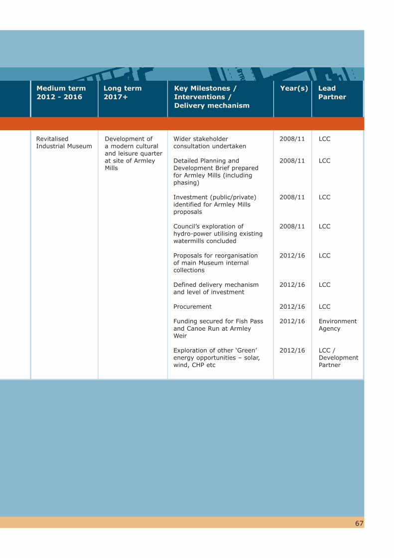
67
Revitalised Industrial Museum
Development of a modern cultural and leisure quarter at site of Armley Mills
Wider stakeholder consultation undertaken
Detailed Planning and Development Brief prepared for Armley Mills (including phasing)
Investment (public/private) identified for Armley Mills proposals
Council’s exploration of hydro-power utilising existing watermills concluded
Proposals for reorganisation of main Museum internal collections
Defined delivery mechanism and level of investment
Procurement
Funding secured for Fish Pass and Canoe Run at Armley Weir
Exploration of other ‘Green’ energy opportunities – solar, wind, CHP etc
2008/11
2008/11
2008/11
2008/11
2012/16
2012/16
2012/16
2012/16
2012/16
LCC
LCC
LCC
LCC
LCC
LCC
LCC
Environment Agency
LCC / Development Partner
Key Milestones /Interventions / Delivery mechanism
Year(s) Lead Partner
Medium term2012 - 2016
Long term2017+

68
RegenerationObjectives
SPD Proposal DevelopmentOpportunity
Obj. 5To improve the quality and usability of greenspace
Obj. 5 &11To enhance the green corridors of waterways
Short term2008 - 2011
i. Armley Moor Attractive greenspace not reaching its full potential as a community resource
ii. Ley LaneLarge area of greenspace laid out as a playing pitch and had a former children’s play area
iii. Dunkirk HillLarge ‘natural’ piece of greenspace with picnic area adjacent to Armley Mills currently subject to anti-social behaviour
iv. Area south of Wortley Heights and Towers An important green link across the West Leeds Gateway area which currently has access and maintenance issues
v. Lower WortleyRecreation GroundCurrently not achieving Leeds Quality Park Standard
Leeds/Liverpool Canal towpath
Improved greenspace attractiveness and usability
Improved signage, facilities and maintenance
Maintenance addressed
Improvements made working towards Leeds Quality Park status. Better quality playing pitches
Improvements made and access from the park to the canal increased
Leeds Waterfront Strategy produced by Aire Action Leeds (Jul 08). Provides a framework for key partners to develop a set of integrated projects to develop and deliver an enhanced corridor of waterways in West Leeds
WL4:The protected greenspaces allocated on the proposals map will be given priority in spending programmes in order to raise their quality and attractiveness and facilitate better connectivity
WL6:The council will also seek either directly or through developer contributions to enhance the historic interest of the canal environment by environmental improvements, directional signage and visitor information
2 West Leeds Gateway Strategic Theme: A Green and Healthy West Leeds
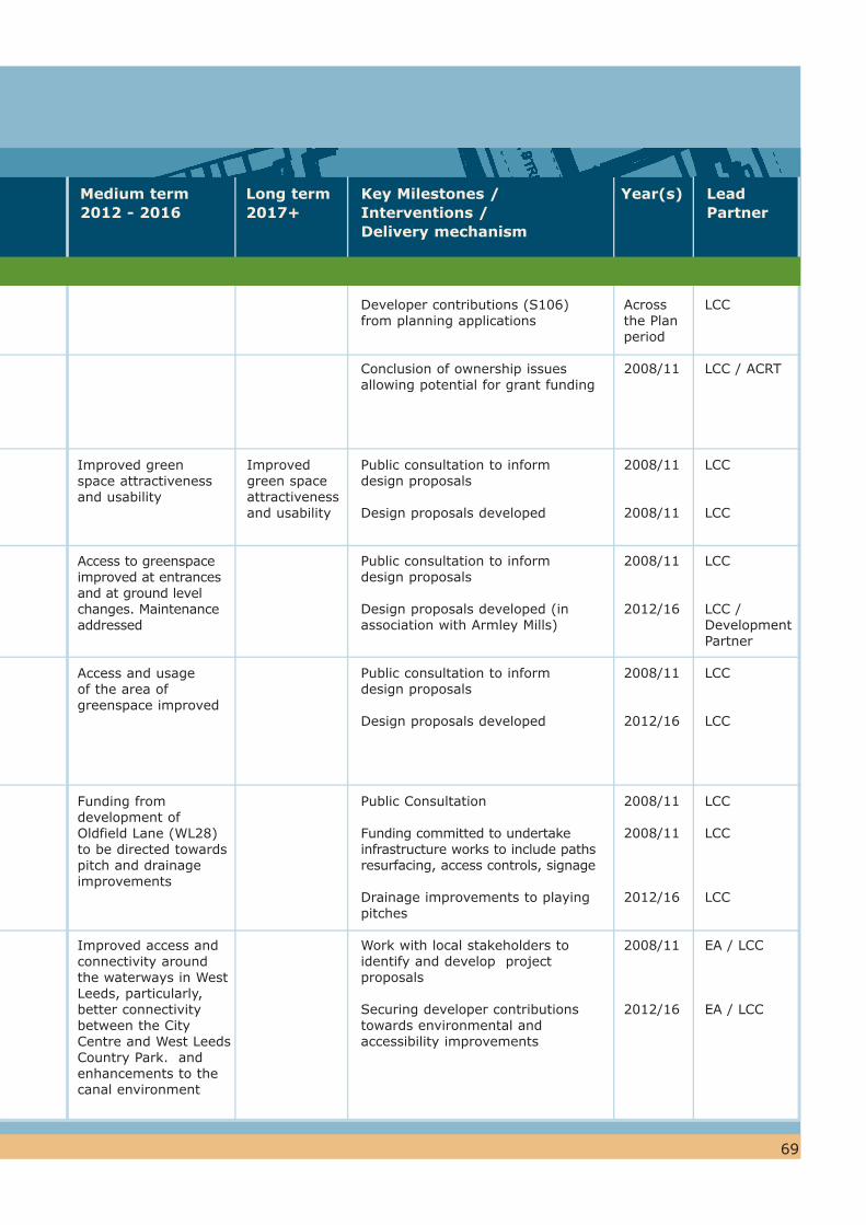
69
Improved green space attractiveness and usability
Access to greenspace improved at entrances and at ground level changes. Maintenance addressed
Access and usage of the area of greenspace improved
Funding from development of Oldfield Lane (WL28) to be directed towards pitch and drainage improvements
Improved access and connectivity around the waterways in West Leeds, particularly, better connectivity between the City Centre and West Leeds Country Park. and enhancements to thecanal environment
Improved green space attractiveness and usability
Developer contributions (S106) from planning applications
Conclusion of ownership issues allowing potential for grant funding
Public consultation to inform design proposals
Design proposals developed
Public consultation to inform design proposals
Design proposals developed (in association with Armley Mills)
Public consultation to inform design proposals
Design proposals developed
Public Consultation
Funding committed to undertake infrastructure works to include paths resurfacing, access controls, signage
Drainage improvements to playing pitches
Work with local stakeholders to identify and develop project proposals
Securing developer contributions towards environmental and accessibility improvements
Acrossthe Plan period
2008/11
2008/11
2008/11
2008/11
2012/16
2008/11
2012/16
2008/11
2008/11
2012/16
2008/11
2012/16
LCC
LCC / ACRT
LCC
LCC
LCC
LCC / Development Partner
LCC
LCC
LCC
LCC
LCC
EA / LCC
EA / LCC
Key Milestones /Interventions / Delivery mechanism
Year(s) Lead Partner
Medium term2012 - 2016
Long term2017+

70
RegenerationObjectives
SPD Proposal DevelopmentOpportunity
Obj. 11To improve connectivity into and out of the area for residents and visitors taking full advantage of the area’s proximity to the two major cities of Leeds & Bradford
Obj. 5 & 11Improve connectivity within the area and links to attractions and greenspaces with specific action required to improve pedestrian links to City Centre (via gyratory) and Kirkstall Renaissance area)
Obj.11Specific action required to improve the environment for pedestrians and cyclists
Short term2008 - 2011
Improved rail transport network between Leeds and Bradford
Enhance existing walking & cycling routes
i. Canal Roadii. Tong Road/
Wellington Roadiii. Armley Town Streetiv. Armley Mills to
Cardigan Fields/ Kirkstall Road
v. The Gyratoryvi. The Canal and Rivervii. Green Lane
New green bridge between New Wortley Estate and Armley Road to provide pedestrian access across Canal Street
Improved environment and public space
Feasibility work to examine the possibility of separating express and stopping trains on the Calderdale and Airedale railway lines
Exploration and identification of opportunities to enhance walking and cycling routes
Feasibility work undertaken to promote a network of green routes as primary links for pedestrians and cyclists
Design work and consultation undertaken
WL9:The City Council will maintain partnership work with the department for Transport, Metro and Bradford Council to further investigate the feasibility of delivering improved connectivity on the rail network between Leeds and Bradford to benefit local communities
WL10: Promote the use of the Canal as a pedestrian and cycle route
WL11: pedestrian and cycle routes will be promoted as primary links
WL12: Any future redevelopment along Armley Road for Employment uses (See WL34) should address the need to integrate proposals with the Kirkstall Renaissance area by an appropriate design and layout including the potential for providing a bridge over the canal
WL13: Environmental improvements to Armley Road
3 West Leeds Gateway Strategic Theme: A Well Connected Area
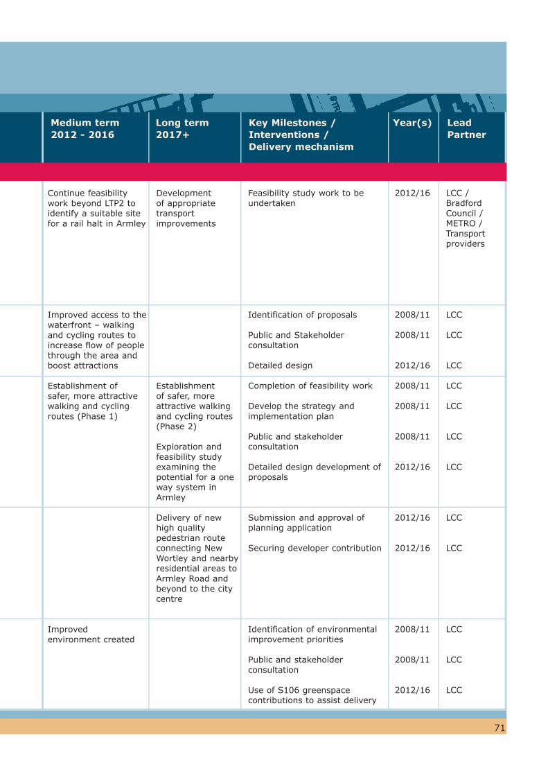
71
Continue feasibility work beyond LTP2 to identify a suitable site for a rail halt in Armley
Improved access to the waterfront – walking and cycling routes to increase flow of people through the area and boost attractions
Establishment of safer, more attractive walking and cycling routes (Phase 1)
Improved environment created
Development of appropriate transport improvements
Establishmentof safer, more attractive walking and cycling routes (Phase 2)
Exploration and feasibility study examining the potential for a one way system in Armley
Delivery of new high quality pedestrian route connecting New Wortley and nearby residential areas to Armley Road and beyond to the city centre
Feasibility study work to be undertaken
Identification of proposals
Public and Stakeholder consultation
Detailed design
Completion of feasibility work
Develop the strategy and implementation plan
Public and stakeholder consultation
Detailed design development of proposals
Submission and approval of planning application
Securing developer contribution
Identification of environmental improvement priorities
Public and stakeholder consultation
Use of S106 greenspace contributions to assist delivery
2012/16
2008/11
2008/11
2012/16
2008/11
2008/11
2008/11
2012/16
2012/16
2012/16
2008/11
2008/11
2012/16
LCC / Bradford Council / METRO / Transport providers
LCC
LCC
LCC
LCC
LCC
LCC
LCC
LCC
LCC
LCC
LCC
LCC
Key Milestones /Interventions / Delivery mechanism
Year(s) Lead Partner
Medium term2012 - 2016
Long term2017+

72
RegenerationObjectives
SPD Proposal DevelopmentOpportunity
Obj. 2To improve the vitality and viability of the Armley Town Centre
Obj. 3To create an inviting and prominent local ‘gateway’ to the area.
Short term2008 - 2011
Armley Town Centre – Townscape Heritage Initiative (THI)
Armley Town Centre
Gelderd Road commercial units
2 Branch Road
Improved pedestrian environment on Town Street, complemented by enhanced bin yard areas as part of the group repair scheme.
Conservation Management Plan approved (Dec 08).
Acquisition of building by LCC. Removal of signage and development of a scheme to restore the building and curtilage. New short / medium term use developed with community benefit
WL15:The City Council will improve the visual and General Environment of the Town Centre by Implementing a Town Centre improvement scheme by the end of 2010
WL16:Supporting the potential refurbishment or redevelopment of Gelder Road units for town centre uses
WL17:2 Branch Road - Remove unauthorised signage and secure a viable future use.
WL18: seek to protect and enhance the attractiveness and identity of Oldfield Lane, New Wortley and Whingate local centres
4 West Leeds Gateway Strategic Theme: A Vibrant Town & Local Centre
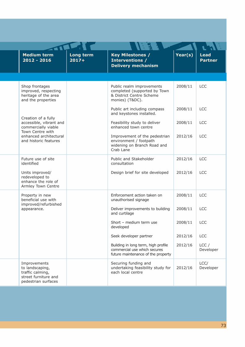
73
Shop frontages improved, respecting heritage of the area and the properties
Creation of a fully accessible, vibrant and commercially viable Town Centre with enhanced architectural and historic features
Future use of site identified
Units improved/ redeveloped to enhance the role of Armley Town Centre
Property in new beneficial use with improved/refurbished appearance.
Improvements to landscaping, traffic calming, street furniture and pedestrian surfaces
Public realm improvements completed (supported by Town & District Centre Scheme monies) (T&DC).
Public art including compass and keystones installed.
Feasibility study to deliver enhanced town centre
Improvement of the pedestrian environment / footpath widening on Branch Road and Crab Lane
Public and Stakeholder consultation
Design brief for site developed
Enforcement action taken on unauthorised signage
Deliver improvements to building and curtilage
Short – medium term use developed
Seek developer partner
Building in long term, high profile commercial use which secures future maintenance of the property
Securing funding and undertaking feasibility study for each local centre
2008/11
2008/11
2008/11
2012/16
2012/16
2012/16
2008/11
2008/11
2008/11
2012/16
2012/16
2012/16
LCC
LCC
LCC
LCC
LCC
LCC
LCC
LCC
LCC
LCC
LCC / Developer
LCC/Developer
Key Milestones /Interventions / Delivery mechanism
Year(s) Lead Partner
Medium term2012 - 2016
Long term2017+
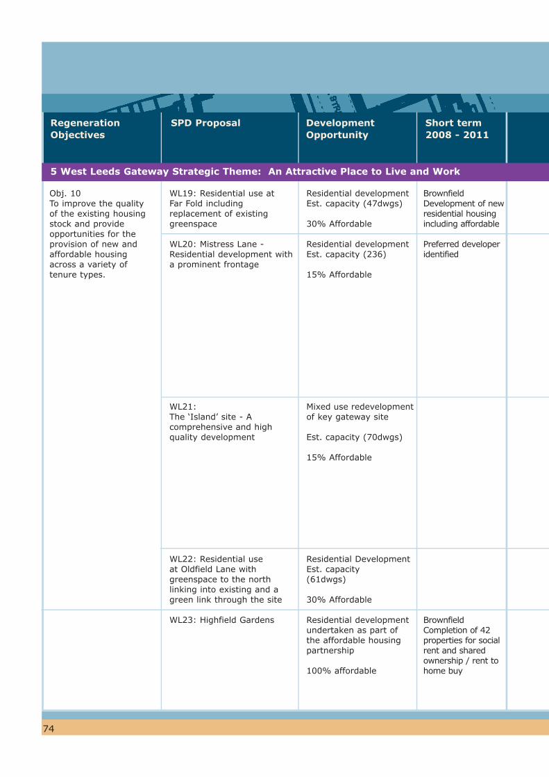
74
RegenerationObjectives
SPD Proposal DevelopmentOpportunity
Obj. 10To improve the quality of the existing housing stock and provide opportunities for the provision of new and affordable housing across a variety of tenure types.
Short term2008 - 2011
Residential development Est. capacity (47dwgs)
30% Affordable
Residential development Est. capacity (236)
15% Affordable
Mixed use redevelopment of key gateway site
Est. capacity (70dwgs)
15% Affordable
Residential DevelopmentEst. capacity (61dwgs)
30% Affordable
Residential development undertaken as part of the affordable housing partnership
100% affordable
Brownfield Development of new residential housing including affordable
Preferred developer identified
Brownfield Completion of 42 properties for social rent and shared ownership / rent to home buy
WL19: Residential use at Far Fold including replacement of existing greenspace
WL20: Mistress Lane - Residential development with a prominent frontage
WL21:The ‘Island’ site - A comprehensive and high quality development
WL22: Residential use at Oldfield Lane with greenspace to the north linking into existing and a green link through the site
WL23: Highfield Gardens
5 West Leeds Gateway Strategic Theme: An Attractive Place to Live and Work
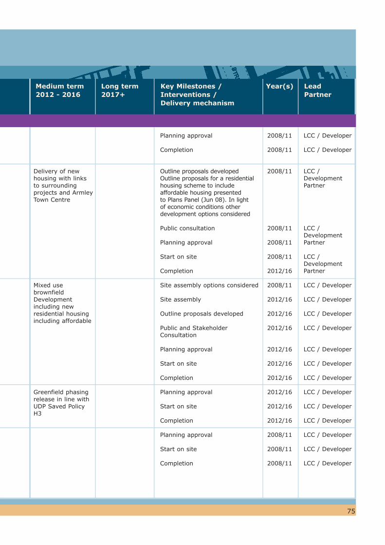
75
Delivery of new housing with links to surrounding projects and Armley Town Centre
Mixed use brownfieldDevelopment including new residential housing including affordable
Greenfield phasing release in line with UDP Saved Policy H3
Planning approval
Completion
Outline proposals developedOutline proposals for a residential housing scheme to include affordable housing presented to Plans Panel (Jun 08). In light of economic conditions other development options considered
Public consultation
Planning approval
Start on site
Completion
Site assembly options considered
Site assembly
Outline proposals developed
Public and Stakeholder Consultation
Planning approval
Start on site
Completion
Planning approval
Start on site
Completion
Planning approval
Start on site
Completion
2008/11
2008/11
2008/11
2008/11
2008/11
2008/11
2012/16
2008/11
2012/16
2012/16
2012/16
2012/16
2012/16
2012/16
2012/16
2012/16
2012/16
2008/11
2008/11
2008/11
LCC / Developer
LCC / Developer
LCC / Development Partner
LCC / Development Partner
LCC / Development Partner
LCC / Developer
LCC / Developer
LCC / Developer
LCC / Developer
LCC / Developer
LCC / Developer
LCC / Developer
LCC / Developer
LCC / Developer
LCC / Developer
LCC / Developer
LCC / Developer
LCC / Developer
Key Milestones /Interventions / Delivery mechanism
Year(s) Lead Partner
Medium term2012 - 2016
Long term2017+
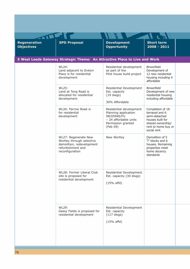
76
RegenerationObjectives
SPD Proposal DevelopmentOpportunity
Short term2008 - 2011
Residential development as part of thePilot house build project
Residential DevelopmentEst. capacity (19 dwgs)
30% Affordable
Residential development Planning application 08/05946/FU– 24 affordable units Permission granted(Feb 09)
New Wortley
Residential Development. Est. capacity (30 dwgs)
(15% affd)
Residential Development Est. capacity(117 dwgs)
(15% affd)
Brownfield Development of 12 new residential housing including 4 affordable
Brownfield Development of new residential housing including affordable
Completion of 18 terraced and 6 semi-detached houses built for shared ownership/ rent to home buy or social rent
Demolition of 5 ‘T’ blocks and 6 houses. Remaining properties meet home decency standards
WL24:Land adjacent to Evelyn Place is for residential development
WL25:Land at Tong Road is allocated for residential development
WL26: Farrow Road is for residential development
WL27: Regenerate New Wortley through selective demolition, redevelopment refurbishment and reconfiguration
WL28: Former Liberal Club site is proposed for residential development
WL29:Gassy Fields is proposed for residential development
5 West Leeds Gateway Strategic Theme: An Attractive Place to Live and Work
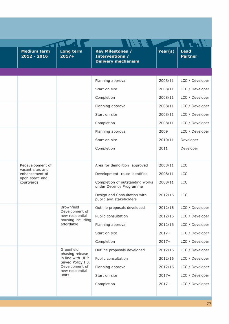
77
Redevelopment of vacant sites and enhancement of open space and courtyards
BrownfieldDevelopment of new residential housing including affordable
Greenfieldphasing release in line with UDP Saved Policy H3. Development of new residential units.
Planning approval
Start on site
Completion
Planning approval
Start on site
Completion
Planning approval
Start on site
Completion
Area for demolition approved
Development route identified
Completion of outstanding works under Decency Programme
Design and Consultation with public and stakeholders
Outline proposals developed
Public consultation
Planning approval
Start on site
Completion
Outline proposals developed
Public consultation
Planning approval
Start on site
Completion
2008/11
2008/11
2008/11
2008/11
2008/11
2008/11
2009
2010/11
2011
2008/11
2008/11
2008/11
2012/16
2012/16
2012/16
2012/16
2017+
2017+
2012/16
2012/16
2012/16
2017+
2017+
LCC / Developer
LCC / Developer
LCC / Developer
LCC / Developer
LCC / Developer
LCC / Developer
LCC / Developer
Developer
Developer
LCC
LCC
LCC
LCC
LCC / Developer
LCC / Developer
LCC / Developer
LCC / Developer
LCC / Developer
LCC / Developer
LCC / Developer
LCC / Developer
LCC / Developer
LCC / Developer
Key Milestones /Interventions / Delivery mechanism
Year(s) Lead Partner
Medium term2012 - 2016
Long term2017+
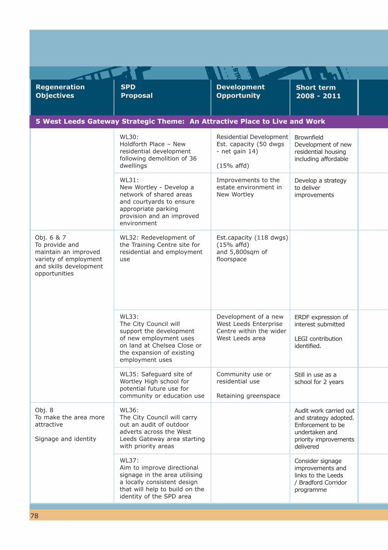
78
RegenerationObjectives
SPDProposal
DevelopmentOpportunity
Obj. 6 & 7To provide and maintain an improved variety of employment and skills development opportunities
Obj. 8 To make the area more attractive
Signage and identity
Short term2008 - 2011
Residential Development Est. capacity (50 dwgs - net gain 14)
(15% affd)
Improvements to the estate environment in New Wortley
Est.capacity (118 dwgs)(15% affd)and 5,800sqm of floorspace
Development of a new West Leeds Enterprise Centre within the wider West Leeds area
Community use or residential use
Retaining greenspace
Brownfield Development of new residential housing including affordable
Develop a strategy to deliver improvements
ERDF expression of interest submitted
LEGI contribution identified.
Still in use as a school for 2 years
Audit work carried out and strategy adopted.Enforcement to be undertaken and priority improvements delivered
Consider signage improvements and links to the Leeds / Bradford Corridor programme
WL30:Holdforth Place – New residential development following demolition of 36 dwellings
WL31:New Wortley - Develop a network of shared areas and courtyards to ensure appropriate parking provision and an improved environment
WL32: Redevelopment of the Training Centre site for residential and employment use
WL33:The City Council will support the development of new employment uses on land at Chelsea Close or the expansion of existing employment uses
WL35: Safeguard site of Wortley High school for potential future use for community or education use
WL36:The City Council will carry out an audit of outdoor adverts across the West Leeds Gateway area starting with priority areas
WL37:Aim to improve directional signage in the area utilising a locally consistent design that will help to build on the identity of the SPD area
5 West Leeds Gateway Strategic Theme: An Attractive Place to Live and Work

79
Development of site in conjunction with other cleared sites
Improved environment delivered in conjunction with development of Holdforth Place and selective demolition
West Leeds Enterprise Centre provided in the area. (Note that this centre may not be located directly within the SPD area)
Feasibility to identify development potential
Delivery of signage improvements and complementarybranding.
Brownfield mixed use development including residential and affordable housing subject to relocation of Centrica training centre
Site to benefit from highway improvements in the gyratory area
Where appropriate development of site
Consistent approach to signage in West Leeds and throughout the Leeds / Bradford Corridor
Development route identified
Design and consultation
Open space improvements
Outline proposals developed
Public consultation on proposals
Secure developer contributions
Initial consultation on proposals for site
Project specification agreed and developed
Feasibility study undertaken
Audit work carried out and strategy adopted to control advertisements in the area
Develop brief
2008/11
2008/11
2012/16
2008/11
2008/11
2012/16
2012/16
2008/11
2012/16
2010/11
2008/11
LCC
LCC
LCC
LCC
LCC
LCC
LCC
LCC
LCC
LCC
LCC
Key Milestones /Interventions / Delivery mechanism
Year(s) Lead Partner
Medium term2012 - 2016
Long term2017+

80
Medium term2012 - 2016
Short term2008 -2011
DevelopmentOpportunity
1 West Leeds Gateway Strategic Theme: West Leeds – A Place to be Proud of
Armley Park
Little Moor and Charlie Cake Park
Historic stone steps and entrance 'arches' from Armley Park at 'Aviaries' down to canal towpath
Armley Leisure Centre
Strawberry Lane Public Open Space
i. Armley Gyratory
ii. A647 Bus Priority measures (Phase 1)
Inner West Area Committee funding used to develop design proposals for areas of greenspace
The steps require improvements to make them more accessible and open up this route from the park to the towpath (part of the West Leeds Country Park & Green Gateways project)
New Leisure Centre provided
Lottery funding allocated to St Bartholomew’s Primary school for the ‘Field of Dreams’ project – fencing access control gates and informal play space
Long term proposals being developed by Highways to reduce size of roundabout and reconfigure roads
Construction commenced April 09
Green flag Status
Delivery of greenspace improvements
Production of detailed plans and identification of potential funding sources
Extra capacity created on westbound carriageway at junction with Branch Road
Table 2: Complementary Projects / Improvements / Funding
2 West Leeds Gateway Strategic Theme: A Green and Healthy West Leeds
3 West Leeds Gateway Strategic Theme: A Well Connected Area
A range of measures for the Armley area is included in the Local Transport Plan 2:
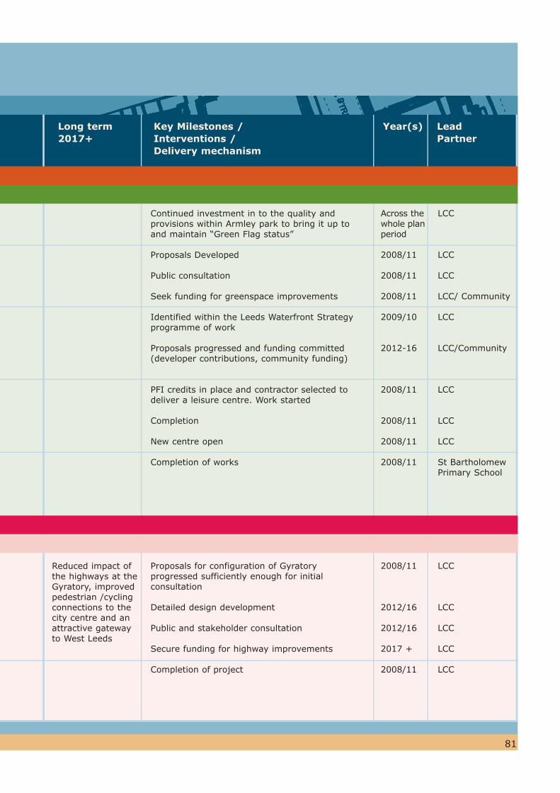
81
Reduced impact of the highways at the Gyratory, improved pedestrian /cycling connections to the city centre and an attractive gateway to West Leeds
Continued investment in to the quality and provisions within Armley park to bring it up to and maintain “Green Flag status”
Proposals Developed
Public consultation
Seek funding for greenspace improvements
Identified within the Leeds Waterfront Strategy programme of work
Proposals progressed and funding committed (developer contributions, community funding)
PFI credits in place and contractor selected to deliver a leisure centre. Work started
Completion
New centre open
Completion of works
Proposals for configuration of Gyratory progressed sufficiently enough for initial consultation
Detailed design development
Public and stakeholder consultation
Secure funding for highway improvements
Completion of project
Across the whole plan period
2008/11
2008/11
2008/11
2009/10
2012-16
2008/11
2008/11
2008/11
2008/11
2008/11
2012/16
2012/16
2017 +
2008/11
LCC
LCC
LCC
LCC/ Community
LCC
LCC/Community
LCC
LCC
LCC
St Bartholomew Primary School
LCC
LCC
LCC
LCC
LCC
Key Milestones /Interventions / Delivery mechanism
Year(s) Lead Partner
Long term2017+
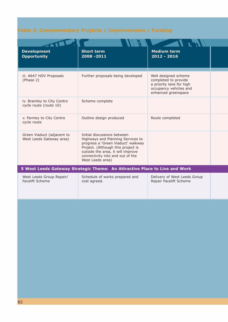
82
Medium term2012 - 2016
Short term2008 -2011
DevelopmentOpportunity
iii. A647 HOV Proposals (Phase 2)
iv. Bramley to City Centre cycle route (route 10)
v. Farnley to City Centre cycle route
Green Viaduct (adjacent to West Leeds Gateway area)
West Leeds Group Repair/Facelift Scheme
Further proposals being developed
Scheme complete
Outline design produced
Initial discussions between Highways and Planning Services to progress a ‘Green Viaduct’ walkway Project. (Although this project is outside the area, it will improve connectivity into and out of the West Leeds area)
Schedule of works prepared and cost agreed.
Well designed scheme completed to provide a priority lane for high occupancy vehicles and enhanced greenspace
Route completed
Delivery of West Leeds Group Repair Facelift Scheme
Table 2: Complementary Projects / Improvements / Funding
5 West Leeds Gateway Strategic Theme: An Attractive Place to Live and Work

83
Design work undertaken
Public and Stakeholder consultation
Construction completed
Detail design completed
Implementation
Detail design completed
Implementation
Renaissance Leeds Partnership Board to approve development projects, potential routes and infrastructure requirements
Confirmation of funds from Regional Housing Board (RHB)
Submission of bid
2008/11
2008/11
2012/16
2008/11
2008/11
2012/16
2012/16
2012/16
2008/11
2012/16
LCC
LCC
LCC
LCC
LCC
LCC
LCC
LCC
LCC
Key Milestones /Interventions / Delivery mechanism
Year(s) Lead Partner
Long term2017+
84
Glossary
Acronym Term Explanation
AffordableHousing
Affordable Housing is housing which provides for the needs of local people who cannot afford to buy or rent on the open market. There are two main types of affordable housing;
- Social rented housing through a Housing Association or Local Authority
- Intermediate Housing - housing at prices and rents above social rents but below market price or rents. Intermediate housing includes 3 main types: (i) shared equity/ownership (where you own a share of the property - get a mortgage for part of the property and pay rent on the remainder), (ii) discounted sale (where the housing association sells at a discounted price - a lease ensures it is sold on at the same level of discount) (iii) intermediate/submarket rent - rented properties where the rents are above social rent but below market rents.
Low cost market housing is not by definition in PPS3 affordable housing.
Brownfield land Any land or premises that has previously been used or developed in association with a permanent structure. It includes gardens, but excludes parks, recreation grounds and allotments.
Consultation A process by which people and organisations are asked their view and are able to make their comments. Consultation is carried out in accordance with the Leeds Statement of Community Involvement (SCI) which was adopted in Feb. 2007. The SCI specifies how stakeholders and communities should be involved in matters relating to planning applications and documents.
CommunityStrategy
A long term vision (10-15 years) for improving the social, economic and environmental well-being of a local area. The Community Strategy for Leeds is the Vision for Leeds 2 (2004-2020).
ConservationArea
An area, designated by a local planning authority for preservation or enhancement because of its special architectural or historic interest under the Planning (Listed Buildings and Conservation Areas) Act 1990.
DEC Development Enquiry Centre
This is the reception for the Council’s City Development Department. It is located at:
The Leonardo Building2 Rossington Street Leeds LS2 8HDTel: (0113) 247 8000 Minicom (0113) 247 4305, Fax: (0113) 247 4117Email: [email protected]: Monday to Friday 08:30–17:00, except Wednesdays 09:30–17:00.

85
Glossary
Acronym Term Explanation
Leeds Bradford Corridor
Partnership between the two cities to revitalise neighbourhoods, employment opportunities, environmental and transport links in the corridor.
Kirkstall Road RenaissanceArea
An area along Kirkstall Road between the A58 flyover and the railway viaduct which is subject to development pressure. A planning framework has been prepared to guide developers for the regeneration of the area.
Greenfield land Land that has not previously been used for urban development. It is normally used for agriculture, forestry, or parks.
Greenspace A collective term to describe greenspace which the public have a right to enter and use for formal or informal recreation. Examples include recreation grounds, parks, linear spaces along canal towpaths or former railway lines, pedestrian areas in the city centre, small play spaces within housing areas, and woodlands.
(Ha) Hectare One hectare (Ha) is equivalent to 10,000 square metres (100m x 100m). This is approximately the same size as a full size football pitch.
Index of multipledeprivation
The most commonly used method of measuring the level of problems and issues in an area. It looks at a number of factors such as income, level of employment, health, and education.
DPD Development Plan document
Documents which Local Planning Authorities are required to prepare in order to set out the future spatial planning framework for their area, as part of the Local Development Framework (LDF). They include the Core Strategy, the Proposals Maps, and Area Action Plans. All DPDs must be subject to rigorous procedures of community involvement, consultation and independent examination. Once adopted, decisions on planning applications must be made in accordance with them.
HMA Leeds Housing MarketAssessment
This study set out a picture of the need for housing across five housing market zones in Leeds, and suggests means to deliver affordable housing to meet the housing need in the future.
LEGI Leeds Local EnterpriseGrowthInitiative
The Initiative aims to promote enterprise within disadvantaged communities, support the growth of locally owned business, and attract investment into deprived areas.
86
Glossary
Acronym Term Explanation
Listed Building Building or other structure of special architectural or historic interest included on a statutory list and assigned a grade (I, II* or II).
LDF Local DevelopmentFramework
The LDF is a collection of development documents which set out the local planning authority’s policies. They take into account the impact of development on the economy, the environment and the social make up of the area. The LDF will eventually replace the UDP(Unitary Development Plan).
Local centres Local centres provide for the day-to-day shopping needs (mainly food and household necessities) of the immediately surrounding communities.
LTP Local Transport Plan
Sets out the agenda for transport planning and investments. West Yorkshire Local Transport Plan 2 (LTP2) sets out a programme for improvements to local transport up to 2011.
Planning Aid Planning Aid is a voluntary service offering free, independent and professional advice and support on planning matters to community groups and individuals who cannot afford to employ a planning consultant. Yorkshire Planning Aid can be contacted on (0113) 204 2462 or email [email protected]
Planning Planning is about how we plan for and make decisions about the future of our cities, towns and countryside. Leeds City Council, as the local planning authority, is responsible for deciding whether a development - anything from an extension on a house to a new shopping centre - should go ahead.
PPG Planning Policy Guidance note
Government guidance on national planning policy. They will be replaced with Planning Policy Statements (PPSs).
Planning Brief A document summarising the planning authority’s guidelines and requirements for the development of a particular site, which includes land use, design and access requirements.
Planning Policy Guidance note 17 Assessment
In order to decide whether a playing field or land/buildings used for sport can be developed for another use, a study must assess whether there is sufficient land or buildings used for sport elsewhere within the local area.
Glossary
Acronym Term Explanation
PPS Planning PolicyStatement
Government statements of national planning policy. PPSs are replacing Planning Policy Guidance notes (PPGs). PPSs are available from the Department of Communities and Local Government by contacting their Enquiry Helpdesk on 020 7944 4400, or they can be viewed online at www.communities.gov.uk.
87
Quality Bus Corridor
A scheme to provide a high standard of bus service along highly congested routes into Leeds city centre. It uses elements such as new bus lanes, Traffic Light Priority and improvements to passenger facilities.
Rapid Transit Route
High quality bus-based public transport routes, with very similar characteristics to a tram scheme, i.e. segregated from other road traffic, highly reliable, and with high quality vehicles.
Rail Plan The strategy for the development of the rail network for the period 2006-11 and which also sets out an approach to longer term developments beyond this period towards 2030.
RenaissanceLeeds
A joint project between Leeds City Council, English Partnerships (now forms part of the Homes & Communities Agency), Yorkshire Forward and Leeds Initiative. It has a key role in delivering major development projects.
SPD Supplementary PlanningDocument
SPDs deal with specific issues (thematic or site specific) and elaborate upon the policy and proposals in Development Plan Documents (DPDs). SPDs will replace Supplementary Planning Guidance.
SDIP Strategic Delivery and ImplemenationPlan
Document identifying the key actions to bring forward te objectives of the West Leeds Gateway Supplementary Planning Document, including the delivery mechanisms, key partners and timescales.
SEGI Site designated as being of county-wide importance for its flora, fauna, geology or landforms.
Site of Ecological or GeologicalImportance
SSSI Site of Special ScientificInterest
Site designated as being of national or international importance for its flora, fauna, geology or landforms. This is a statutory designation operated throughout Great Britain.
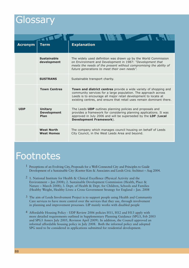
88
Glossary
Footnotes
Acronym Term Explanation
Sustainabledevelopment
The widely used definition was drawn up by the World Commission on Environment and Development in 1987: “Development that meets the needs of the present without compromising the ability of future generations to meet their own needs”.
UDP Unitary DevelopmentPlan
The Leeds UDP outlines planning policies and proposals and provides a framework for considering planning applications. It was approved in July 2006 and will be superseded by the LDF (LocalDevelopment Framework).
SUSTRANS Sustainable transport charity.
Town Centres Town and district centres provide a wide variety of shopping and community services for a large population. The approach across Leeds is to encourage all major retail development to locate at existing centres, and ensure that retail uses remain dominant there.
West NorthWest Homes
The company which manages council housing on behalf of Leeds City Council, in the West Leeds Area and beyond.
1 Perceptions of an Evolving City, Proposals for a Well-Connected City and Principles to Guide Development of a Sustainable City (Koetter Kim & Associates and Leeds Civic Architect – Aug 2004.
2 1. National Institute for Health & Clinical Excellence (Physical Activity and the Environment – Jan 2008); 2. Sustainable Development Commission (Health, Place & Nature – March 2008); 3. Dept. of Health & Dept. for Children, Schools and Families (Healthy Weight, Healthy Lives: a Cross Government Strategy for England – Jan. 2008
3 The aim of Leeds Involvement Project is to support people using Health and Community Care services to have more control over the services that they use, through involvement in planning and improvement processes. LIP mainly works with disabled people
4 Affordable Housing Policy - UDP Review 2006 policies H11, H12 and H13 apply with more detailed requirements outlined in Supplementary Planning Guidance (SPG3, Feb 2003 and SPG3 Annex July 2005, Revision April 2009). In addition, the Council approved an informal affordable housing policy in July 2008. Both the informal policy and adopted SPG need to be considered in applications submitted for residential development.


West Leeds Gateway Leeds Local Development Framework
Supplementary Planning DocumentAdopted October 2010
Contact Details
Write to: WLG Team Forward Planning and Implementation City Development Leeds City Council 2 Rossington Street LEEDS LS2 8HD
Telephone: (0113) 247 8092
Email: [email protected]
Web: www.leeds.gov.uk/ldf
Cov
er p
rinte
d o
n p
aper
mad
e fr
om
80%
post
consu
mer
was
te a
nd 2
0%
rec
ycle
d indust
rial
fi b
res