west river watershed plan ct
DESCRIPTION
The West River watershed is home to approximately 75,000 residents.Issues Facing the WatershedDegraded Water QualityA 3.2-mile segment of the West River stretching from Konolds Pond to Edgewood Park Pond is impaired. The Statewide Bacteria TMDL for the West River can be achieved by implementing actions that will reduce bacterial loads using a watershed framework. This watershed-based plan therefore provides a framework for implementing the TMDL. Ultimately, the goal of both the watershed plan and the TMDL is to improve the water quality of the West River.TRANSCRIPT
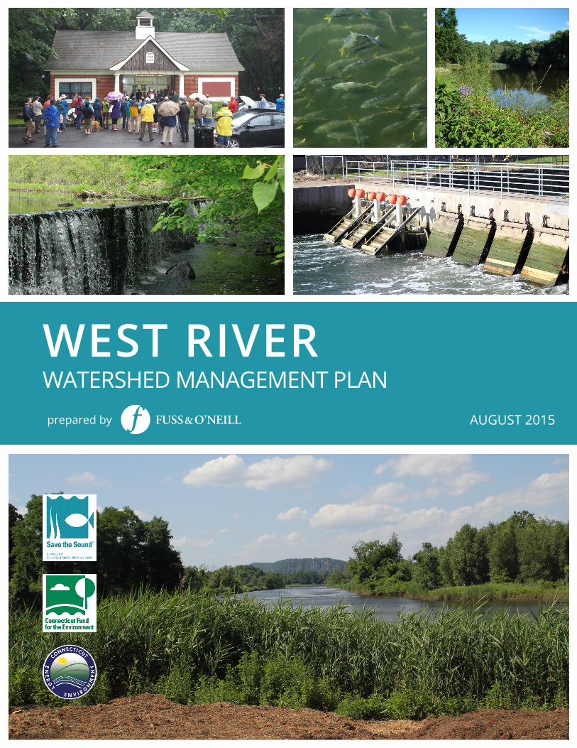
WEST RIVERWATERSHED MANAGEMENT PLAN
AUGUST 2015prepared by
West River Watershed Management Plan
AcknowledgementsWe would like to thank the following individuals and organizations for their contributions of time and effort tothe development of this plan:
Project Steering CommitteeChelsea Auerback, West River Watershed Coalition, New Haven Resident, Student, Yale LawLynne Bonnett, Greater New Haven Waterworks Coalition, New Haven Environmental Justice NetworkFrank Cochran, New Haven, Friends of Edgewood ParkFrank Deleo, Woodbridge Resident, West River Watershed Coalition MemberKathy Fay, Neighborhood Housing Services, New HavenChris Malik, Connecticut Department of Energy and Environmental ProtectionAdam Marchand, Alderman, Ward 25, New HavenCourtney McGinnis, Hamden Resident, Assistant Professor of Biology at Quinnipiac UniversityMary Mushinsky, River Advocates of South Central Connecticut (formerly with Mill River WatershedAssociation)Stacy R. Spell, West River Community Member, Civic LeaderRon Walters, South Central Connecticut Regional Water AuthorityGiovanni Zinn, City Engineer, City of New HavenGary Zrelak, Greater New Haven Water Pollution Control Authority
Other Involved StakeholdersCity of New Haven – Karyn Gilvarg, Executive Director, City Plan Department; Rebecca Bombero, Director NewHaven Parks, Recreation and TreesCity of West Haven – Gail Burns, City Council Member, 10th District; Rob Librandi, Assistant City PlannerCommon Ground High School – David Edgeworth, Joel Toleman and the Common Ground West River StewardsFriends of Beaver Ponds Park – Nan Bartow and William BidwellFriends of Edgewood Park – Stephanie FitzgeraldNeighborhood Housing ServicesSolar Youth – Joanne SculliTown of Hamden – Robert Brinton, City Engineer; Tom Vocelli, Inland Wetlands Enforcement OfficerTown of Woodbridge – Ellen Scalettar, First SelectwomanUrban Resources Initiative – Collen Murphy Dunning, Executive DirectorWest River Watershed CoalitionWestville Village Renaissance Alliance – Chris Heitman, Executive Director
Save the Sound/Connecticut Fund for the EnvironmentKendall Barbery, Green Infrastructure Program ManagerJohn Champion, Director of Green ProjectsGwen Macdonald, Director of Habitat RestorationAnnalisa Paltauf, Green Projects Administrative AssistantBrian Holdt, Green Projects Administrator
Consultant – Fuss & O’Neill, Inc.Erik Mas, P.E.; Diane Mas, Ph.D.; Meghan Flanagan, EIT; Kristine Baker, P.E.; Jonathan Allard, PLA; David Askew,CPESC
Cover photos taken and provided by Save the Sound/Connecticut Fund for the Environment.
Funding support for this plan was provided by the Connecticut Department of Energy and Environmental Protectionthrough a U.S. EPA Clean Water Act Section 319 grant.
Table of ContentsWest River Watershed Management Plan
West River Watershed Management Plan i
1 Introduction ................................................................................ 11.1 Background ..................................................................................................................... 11.2 Why Develop a Watershed Plan? ..................................................................................... 81.3 Plan Development Process .............................................................................................. 81.4 Public Participation and Outreach ................................................................................... 11
2 Watershed Management Goals and Objectives ................... 13
3 Management Recommendations ........................................... 163.1 Capacity Building ............................................................................................................ 17
3.1.1 Establish a Framework and Lead Entity .................................................................... 173.1.2 Promote Inter-Municipal Coordination .................................................................... 173.1.3 Promote Regional Collaboration ............................................................................... 193.1.4 Identify and Pursue Funding ..................................................................................... 203.1.5 Conduct Streamwalk Assessments ........................................................................... 203.1.6 Prepare and Implement Subwatershed Action Plans ................................................ 22
3.2 Water Quality ................................................................................................................. 243.2.1 Water Quality Monitoring ........................................................................................ 243.2.2 Combined Sewer Overflows ..................................................................................... 283.2.3 Green Infrastructure and Low Impact Development ................................................ 293.2.4 Residential Low Impact Development ...................................................................... 343.2.5 Municipal Stormwater Management Programs ........................................................ 383.2.6 Subsurface Sewage Disposal Systems ....................................................................... 393.2.7 Illicit Connections and Discharges ............................................................................ 413.2.8 Commercial and Industrial Land Use ........................................................................ 433.2.9 Wildlife and Pet Waste ............................................................................................. 463.2.10 Natural Stream Buffers ............................................................................................. 48
3.3 Habitat Protection and Restoration ................................................................................ 513.3.1 Protect and Restore In-Stream Habitat ..................................................................... 513.3.2 Protect and Restore Forested Areas and Tree Canopy .............................................. 543.3.3 Manage Invasive Plant Species ................................................................................. 553.3.4 Protect and Restore High-Priority Wetland and Open Water Habitat ....................... 56
3.4 Sustainable Land Use, Open Space, and Public Access ..................................................... 593.4.1 Strengthen Land Use Regulations ............................................................................. 593.4.2 Increase Flood Resilience Using a Watershed Approach .......................................... 633.4.3 Preserve and Protect Open Space ............................................................................. 653.4.4 Increase Public Access to the River ........................................................................... 66
3.5 Education and Outreach ................................................................................................. 693.5.1 Implement a Public Outreach Campaign .................................................................. 693.5.2 Homeowner Education and Outreach ...................................................................... 753.5.3 Outreach to Municipalities and Volunteer Groups ................................................... 77
Table of ContentsWest River Watershed Management Plan
West River Watershed Management Plan ii
3.5.4 Outreach to Business Community ............................................................................ 773.5.5 Outreach to Institutional Property Owners .............................................................. 783.5.6 Promote Community Engagement Events ................................................................ 783.5.7 Promote Youth Education, Community Service, and Stewardship Programs ........... 793.5.8 Address Homeless Encampments ............................................................................. 79
4 Pollutant Load Reductions ....................................................... 81
5 Funding Sources ....................................................................... 87
6 References ................................................................................ 88
Tables Page3-1 Capacity Building Recommendations 183-2 Local, Regional and State Organizations 193-3 Target Subwatersheds for Development of Subwatershed Action Plans 233-4 Water Quality Monitoring Recommendations 273-5 Combined Sewer Overflow and Green Infrastructure Recommendations 303-6 Residential Low Impact Development Recommendations 373-7 Municipal Stormwater Management Program Recommendations 403-8 Subsurface Sewage Disposal Systems Recommendations 403-9 Illicit Connections and Discharges Recommendations 423-10 Commercial and Industrial Land Use Recommendations 453-11 Wildlife and Pet Waste Recommendations 473-12 Stream Buffer Recommendations 493-13 Habitat Protection and Restoration Recommendations 523-14 Land Use, Open Space, and Public Access Recommendations 603-15 Education and Outreach Recommendations 715-1 Modeled Annual Pollutant Load Reductions 845-2 Modeled Annual Pollutant Load Reductions for Varying Levels of Green Infrastructure
Implementation 84
Figures Page1-1 West River Watershed 21-2 Aerial View of West River Watershed 31-3 Maltby Lakes Subwatershed 41-4 Water Quality Impairments in the West River Watershed 65-1 Modeled Reductions in Annual Fecal Indicator Bacteria Loads and Runoff Volumes 855-2 Modeled Existing (2014) and Future (2036) Annual Fecal Indicator Bacteria Loads 85
Table of ContentsWest River Watershed Management Plan
West River Watershed Management Plan iii
Appendices End of DocumentA West River Watershed Management Plan, Technical Memorandum #1: State of the Watershed (on CD)B Watershed Survey ResponsesC Technical Memorandum #2: Low Impact Development and Green Infrastructure Assessment (on CD)D Project Steering Committee Meeting SummariesE Community Workshop Meeting SummariesF Streamwalk Assessment Training and Preliminary ResultsG Pollutant Load Reduction Model ResultsH Potential Funding Sources
West River Watershed Management Plan 1
1 Introduction1.1 Background
The West River and Its Watershed
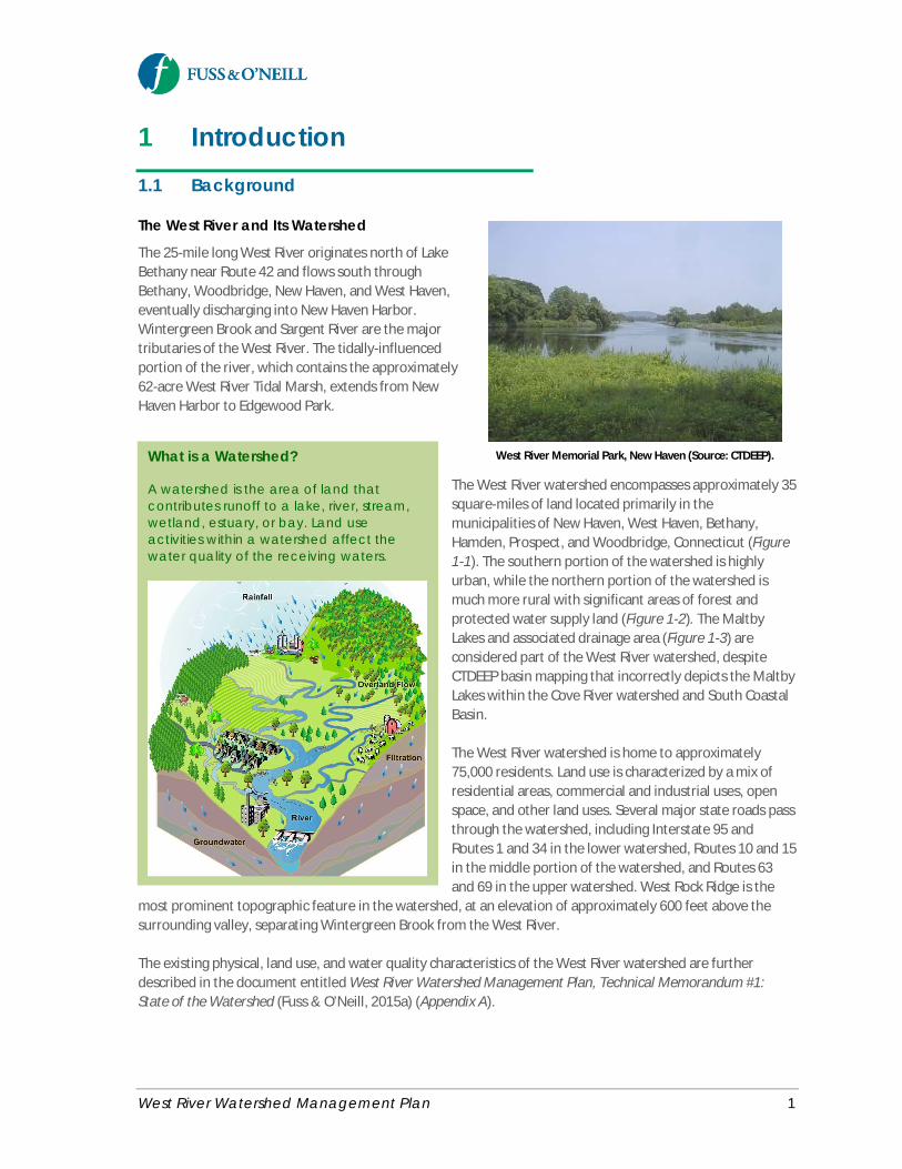
The 25-mile long West River originates north of LakeBethany near Route 42 and flows south throughBethany, Woodbridge, New Haven, and West Haven,eventually discharging into New Haven Harbor.Wintergreen Brook and Sargent River are the majortributaries of the West River. The tidally-influencedportion of the river, which contains the approximately62-acre West River Tidal Marsh, extends from NewHaven Harbor to Edgewood Park.
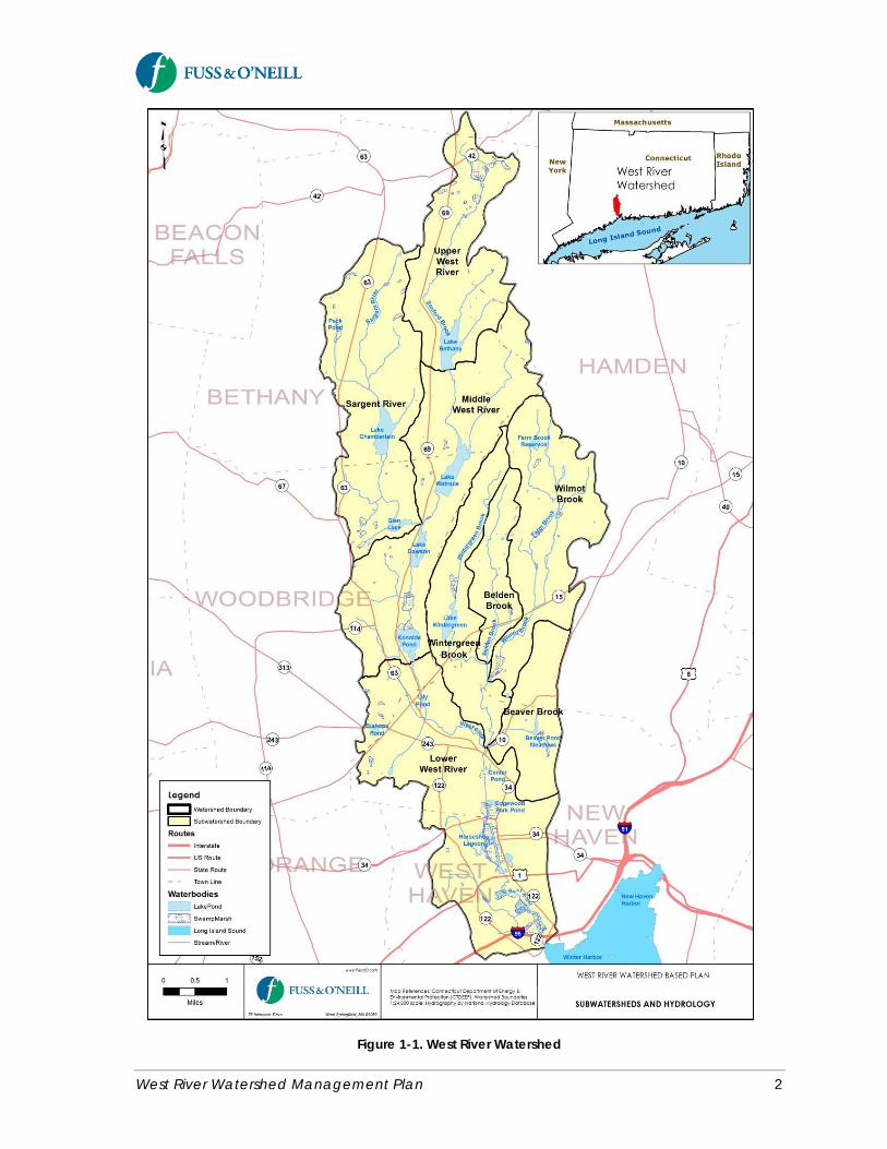
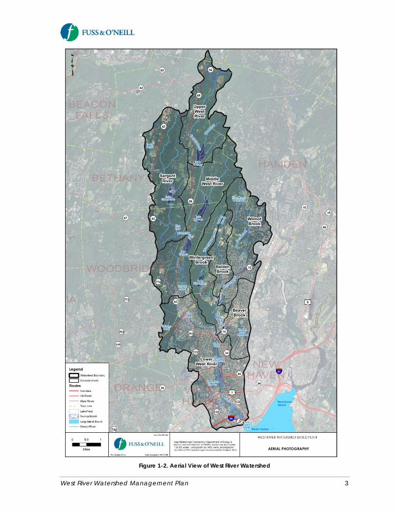
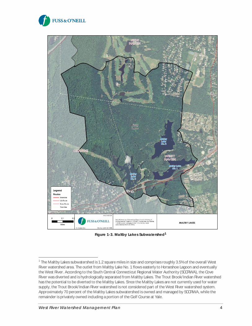
The West River watershed encompasses approximately 35square-miles of land located primarily in themunicipalities of New Haven, West Haven, Bethany,Hamden, Prospect, and Woodbridge, Connecticut (Figure1-1). The southern portion of the watershed is highlyurban, while the northern portion of the watershed ismuch more rural with significant areas of forest andprotected water supply land (Figure 1-2). The MaltbyLakes and associated drainage area (Figure 1-3) areconsidered part of the West River watershed, despiteCTDEEP basin mapping that incorrectly depicts the MaltbyLakes within the Cove River watershed and South CoastalBasin.
The West River watershed is home to approximately75,000 residents. Land use is characterized by a mix ofresidential areas, commercial and industrial uses, openspace, and other land uses. Several major state roads passthrough the watershed, including Interstate 95 andRoutes 1 and 34 in the lower watershed, Routes 10 and 15in the middle portion of the watershed, and Routes 63and 69 in the upper watershed. West Rock Ridge is the
most prominent topographic feature in the watershed, at an elevation of approximately 600 feet above thesurrounding valley, separating Wintergreen Brook from the West River.
The existing physical, land use, and water quality characteristics of the West River watershed are furtherdescribed in the document entitled West River Watershed Management Plan, Technical Memorandum #1:State of the Watershed (Fuss & O’Neill, 2015a) (Appendix A).
What is a Watershed?
A watershed is the area of land thatcontributes runoff to a lake, river, stream,wetland, estuary, or bay. Land useactivities within a watershed affect thewater quality of the receiving waters.
West River Memorial Park, New Haven (Source: CTDEEP).
West River Watershed Management Plan 2
Figure 1-1. West River Watershed
West River Watershed Management Plan 3
Figure 1-2. Aerial View of West River Watershed
West River Watershed Management Plan 4
Figure 1-3. Maltby Lakes Subwatershed1
1 The Maltby Lakes subwatershed is 1.2 square miles in size and comprises roughly 3.5% of the overall WestRiver watershed area. The outlet from Maltby Lake No. 1 flows easterly to Horseshoe Lagoon and eventuallythe West River. According to the South Central Connecticut Regional Water Authority (SCCRWA), the CoveRiver was diverted and is hydrologically separated from Maltby Lakes. The Trout Brook/Indian River watershedhas the potential to be diverted to the Maltby Lakes. Since the Maltby Lakes are not currently used for watersupply, the Trout Brook/Indian River watershed is not considered part of the West River watershed system.Approximately 70 percent of the Maltby Lakes subwatershed is owned and managed by SCCRWA, while theremainder is privately owned including a portion of the Golf Course at Yale.
West River Watershed Management Plan 5
Issues Facing the Watershed
Degraded Water QualityThe West River, like many suburban and urban rivers andstreams in Connecticut, has been impacted by historicaldevelopment and land use activities in its watershed.Water quality in the lower reaches of the West River isdegraded due to elevated bacteria levels resulting fromstormwater runoff, agriculture, combined seweroverflows, illicit discharges, pets, wildlife, and othersources. This has resulted in water quality “impairments,”which means that the waterbodies cannot supportcertain types of uses such as recreation or habitat foraquatic life. In contrast, the water quality in the upperportions of the watershed is very good, supportingsurface drinking water supplies and cold water fisheries,which reflects the large areas of forested land and sparsedevelopment in the upper watershed.
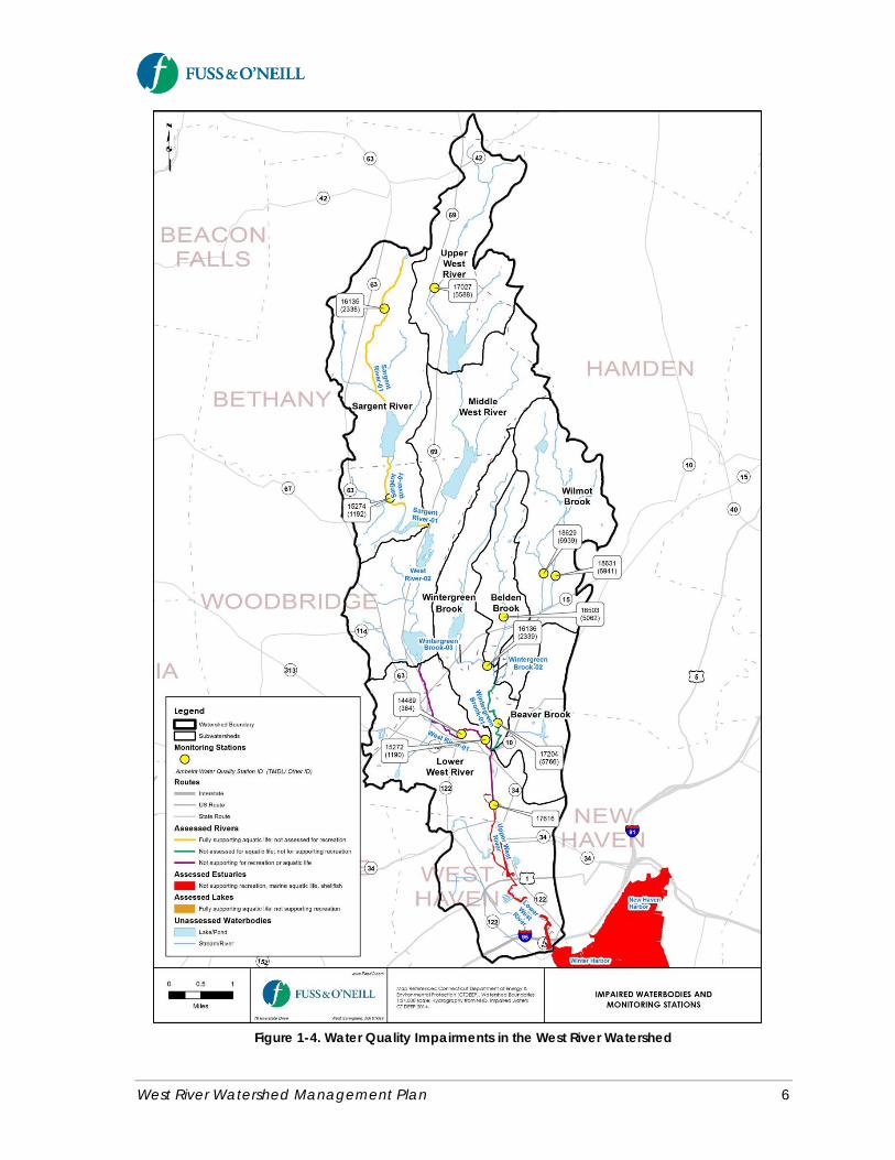
A 3.2-mile segment of the West River stretching from theoutlet of Konolds Pond to Edgewood Park Pond has beenidentified as impaired for recreation due to bacteria andimpaired for aquatic life due to unknown causes (Figure1-4). The estuary portions of the West River south ofEdgewood Park Pond are impaired for recreation due tobacteria; marine life due to dissolved oxygen saturation,nutrients, oils and grease, dissolved oxygen, and PCBs; and shellfish due to bacteria. Edgewood Park Pond isimpaired for recreation due to bacteria. The southern portion of Wintergreen Brook where it joins the WestRiver is also impaired for recreation due to bacteria (CTDEEP, 2012).
In 2012, the Connecticut Department of Energy and Environmental Protection (CTDEEP) developed a TotalMaximum Daily Load (TMDL) – essentially a “pollution budget” – for bacteria-impacted waterbodies statewide,including the West River, to begin addressing the bacteria impairments. The TMDL identified reductions infecal indicator bacteria loads to the West River that are necessary for the impaired segments to meet Statewater quality standards and once again support contact recreation and provide suitable aquatic habitat.
The Statewide Bacteria TMDL for the West River can be achieved by implementing actions that will reducebacterial loads using a watershed framework. This watershed-based plan therefore provides a framework forimplementing the TMDL. Ultimately, the goal of both the watershed plan and the TMDL is to improve the waterquality of the West River.
The West River – A Contrast in WaterQualityThe water quality in the lower reaches ofthe West River is degraded due to elevatedlevels of bacteria and other pollutantsresulting from combined sewer overflows,illicit discharges, and nonpoint sources suchas stormwater runoff from developedareas. The poor water quality in the lowerWest River cannot support contactrecreation or habitat for aquatic life.
In contrast, the water quality in the upperportions of the watershed is very good,supporting surface drinking water suppliesand cold water fisheries.
The difference in water quality betweenthe upper and lower portions of the WestRiver highlights the strong influence ofwatershed land use activities on waterquality and the importance of watershedmanagement to address the water qualityproblems in the lower watershed.
West River Watershed Management Plan 6
Figure 1-4. Water Quality Impairments in the West River Watershed
West River Watershed Management Plan 7
Urban stormwater runoff is a significant source of pollutants and a leading cause of water quality impairmentsin the West River. Stormwater runoff from developed areas and other nonpoint sources of pollution in thewatershed are major contributors of bacteria, sediment, and nutrients. Stormwater runoff collected by thecombined sanitary and storm sewer system in the City of New Haven also contributes to Combined SewerOverflow (CSO) discharges to the West River during periods of heavy rainfall, when the combined sewersystem becomes overwhelmed and untreated sewage is discharged directly to the river.
The Greater New Haven Water Pollution Control Authority (GNHWPCA) is in the process of implementing along-term plan to reduce CSOs to the West River, which includes traditional gray infrastructure and greeninfrastructure2 approaches. In addition to GNHWPCA, the City of New Haven, private development, and othergroups are implementing green infrastructure in the West River watershed, which will reduce CSO discharges,runoff volumes, and wet weather pollutant loads.
Loss of HabitatHistorical development in the watershed and other factors are also responsible for loss of important habitatsincluding inland wetlands, tidal marsh, natural vegetation along stream corridors, aquatic habitat, and forests.The West River and its tributaries were once important habitat for anadromous3 fish species, although urbandevelopment and flood control projects have diminished the quality and extent of fisheries in the watershed.The lower portions of the West River (e.g., West River Memorial Park and Edgewood Park) have been the focusof efforts by various groups over the past decade to restore lost or degraded habitat.
Limited River AccessAccess to many portions of the West River is limited due to development along the river and the presence ofmajor roads that cut-off the river from the surrounding neighborhoods (e.g., Ella T. Grasso Boulevard).Improved access to the West River and its tributaries is needed to enhance recreational opportunities as wellas public appreciation and stewardship of the river.
FloodingPortions of the West River and its tributaries have a long history of flooding as a result of historicaldevelopment in the watershed. The U.S. Army Corps of Engineers spent much of the 1900s redirecting theWest River to suit industrial and flood control needs. Urban flooding is common in some of the more urbanizedareas of the watershed where storm drainage systems are over-capacity during some storms. Riverine floodingis also a significant and frequent problem in some areas, particularly near Blake Street, the Woodbridge Flatsarea, and along Wilmot Brook (also known locally as Farm Brook).
2 Green infrastructure refers to systems and practices that reduce runoff through the use of vegetation, soils,and natural processes to manage water and create healthier urban and suburban environments (EPA, 2014).When applied to sites or neighborhoods, green infrastructure includes stormwater management practices suchas rain gardens, permeable pavement, green and blue roofs, green streets, infiltration planters, trees and treeboxes, and rainwater harvesting. These practices capture, manage, and/or reuse rainfall close to where it falls,thereby reducing stormwater runoff and keeping it out of receiving waters.
3 Anadromous fish begin life in freshwater, migrate to the sea to reach maturity, and return to freshwater tospawn.
West River Watershed Management Plan 8
1.2 Why Develop a Watershed Plan?
Save the Sound, the West River Watershed Coalition, thewatershed communities, and the CTDEEP recognize the need toaddress the water quality issues of the West River and itstributaries using a watershed-based approach. A primary way todo this is by developing and implementing a comprehensivewatershed management plan. The watershed plan provides ablueprint to help groups within the watershed work acrossmunicipal boundaries to better protect and restore waterresource conditions throughout the watershed.
The major objectives of developing a watershed-based management plan for the West River are to:
· Characterize current watershed conditions and issues· Identify specific actions to protect and improve water quality, but also address related issues such as
habitat restoration, land use planning, open space protection, public access and recreation, andflooding
· Incorporate ongoing and planned stewardship efforts in the watershed· Facilitate capacity-building and engage the watershed municipalities and other stakeholder groups in
the watershed planning process and future plan implementation· Promote collaboration across municipal boundaries, bringing the watershed communities and groups
together to cooperate around shared issues of concern and objectives without compromising their“home rule” principles
· Create a plan that satisfies EPA and CTDEEP requirements for watershed-based plans to betterposition the West River for future grant funding from certain State and Federal sources.
1.3 Plan Development Process
Save the Sound partnered with the West River Watershed Coalition, CTDEEP, the watershed municipalities, andother groups to develop a watershed management plan for the West River. Funding for this project wasprovided by the CTDEEP through a U.S. EPA Clean Water Act Section 319 grant. Fuss & O’Neill, Inc. wasretained by Save the Sound to lead the development of the watershed management plan.
This plan has been developed consistent with EPA and CTDEEP guidance for watershed-based plans. Theguidance outlines nine key elements (see text box on the following page) that establish the structure of theplan, including specific goals, objectives, and strategies to protect and restore water quality; methods to buildand strengthen working partnerships; a dual focus on addressing existing problems and preventing new ones;a strategy for implementing the plan; and a feedback loop to evaluate progress and revise the plan asnecessary. Following this approach will enable implementation projects under this plan to be considered forfunding under Section 319 of the Clean Water Act and improve the chances for funding through other Stateand Federal sources.
Watershed ManagementWatershed planning is a process thatidentifies ways to protect and restorethe water quality and other naturalresources in a watershed. Theoutcome of the watershed planningprocess is documented in awatershed management plan.
West River Watershed Management Plan 9
Development of the watershed management planconsisted of the following tasks.
Project Steering CommitteeA Project Steering Committee was formed to guide theplan development. The Steering Committee consisted ofrepresentatives from the watershed municipalities,government organizations, educational institutions, non-profit organizations, and others who live and work withinthe watershed.
A series of workshop meetings were held with theSteering Committee and other invited stakeholders todiscuss issues of concern in the watershed and to identifywatershed planning goals and objectives that would formthe basis of the plan recommendations. The SteeringCommittee and other stakeholders also provided reviewcomments on draft deliverables. The watershed planreflects the combined efforts of Save the Sound, the WestRiver Watershed Coalition, the watershed municipalities,CTDEEP, other stakeholders, and the Fuss & O’Neillproject team. Members of the Project Steering Committee and other individuals involved in the plandevelopment process are listed in the Acknowledgments section at the beginning of this document.
State of the Watershed AssessmentA baseline assessment was performed to document the existing physical, land use, and water qualitycharacteristics of the West River watershed. The project team reviewed existing watershed data, studies, andreports; compiled and analyzed GIS mapping of the watershed and various subwatersheds; and developedpollutant loading and impervious cover estimates for the watershed. The document entitled West RiverWatershed Management Plan, Technical Memorandum #1: State of the Watershed (Fuss & O’Neill, 2015a)serves as a basis for the watershed plan recommendations and also provides a background referencedocument to support future implementation activities within the watershed. A copy of the technicalmemorandum is provided on CD in Appendix A of this plan.
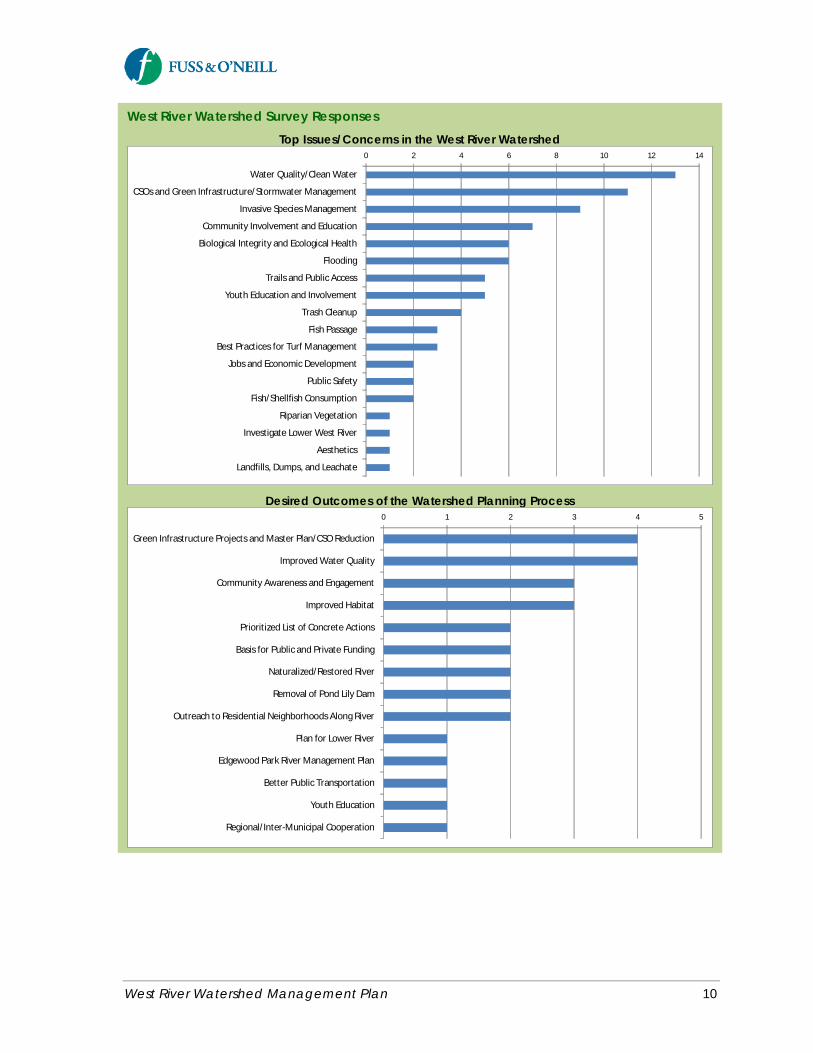
Watershed SurveyA survey was conducted to obtain early feedback from the Project Steering Committee and other stakeholdersregarding the top concerns and issues in the West River watershed and the desired outcomes of the watershedplanning process. The survey was completed on-line using Constant Contact and by filling out paper forms insome cases. The survey results are provided in Appendix B of this plan. The following text box summarizes keyresponses to the watershed survey.
EPA Nine Key Elements of a Watershed-Based Plan
a. Identify causes and sources ofpollution
b. Estimate pollutant loading to thewatershed and the expected loadreductions
c. Describe management measuresthat will achieve load reductionsand targeted critical areas
d. Estimated amount of technical andfinancial assistance and therelevant authorities needed toimplement the plan
e. Develop andinformation/education component
f. Develop a project scheduleg. Describe the interim, measurable
milestonesh. Identify indicators to measure
progressi. Develop a monitoring component
West River Watershed Management Plan 10
West River Watershed Survey ResponsesTop Issues/Concerns in the West River Watershed
0 2 4 6 8 10 12 14
Water Quality/Clean Water
CSOs and Green Infrastructure/Stormwater Management
Invasive Species Management
Community Involvement and Education
Biological Integrity and Ecological Health
Flooding
Trails and Public Access
Youth Education and Involvement
Trash Cleanup
Fish Passage
Best Practices for Turf Management
Jobs and Economic Development
Public Safety
Fish/Shellfish Consumption
Riparian Vegetation
Investigate Lower West River
Aesthetics
Landfills, Dumps, and Leachate
Desired Outcomes of the Watershed Planning Process0 1 2 3 4 5
Green Infrastructure Projects and Master Plan/CSO Reduction
Improved Water Quality
Community Awareness and Engagement
Improved Habitat
Prioritized List of Concrete Actions
Basis for Public and Private Funding
Naturalized/Restored River
Removal of Pond Lily Dam
Outreach to Residential Neighborhoods Along River
Plan for Lower River
Edgewood Park River Management Plan
Better Public Transportation
Youth Education
Regional/Inter-Municipal Cooperation
West River Watershed Management Plan 11
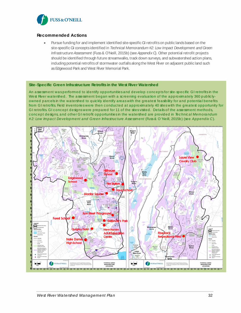
Green Infrastructure AssessmentAn assessment was performed to identify opportunities and develop concepts for site-specific greeninfrastructure retrofits in the West River watershed. The assessment included a screening evaluation to quicklyidentify areas of the watershed with the greatest feasibility for and potential benefits from green infrastructureretrofits, field inventories of the most promising green infrastructure retrofit opportunities in the watershedidentified from the screening step, and green infrastructure concept designs for selected retrofit sites. The site-specific project concepts are intended to serve as future implementation projects and examples of the types ofprojects that could also be implemented for other similar land uses and locations in the watershed. Themethods and findings of this assessment are documented in Technical Memorandum #2: Low ImpactDevelopment and Green Infrastructure Assessment (Fuss & O’Neill, 2015b). A copy of the technicalmemorandum is provided on CD in Appendix C of this plan.
Plan Goals and ObjectivesThe project team developed a series of goals and objectives for the watershed plan. The goals and objectiveswere further refined by the Project Steering Committee and other watershed stakeholders and are presentedin Section 2 of this document.
Plan RecommendationsPotential management actions were identified for each of the plan goals and objectives and subsequentlyrefined based upon input from the Project Steering Committee and other stakeholders, culminating in themanagement recommendations that are presented in Section 3 of this document.
1.4 Public Participation and Outreach
Public participation and outreach was conducted as part of the watershed planning process to increase publicunderstanding of issues affecting the watershed, to encourage participation in the development of thewatershed plan, and to build support for implementation of the plan. The following public outreach activitiesoccurred during the watershed planning process:
· October 2014 – A Project Steering Committee was formed in October 2014. An initial project kickoffmeeting was held with the Steering Committee and other invited stakeholders on October 16, 2014 atNeighborhood Housing Services of New Haven. The watershed survey was circulated to thestakeholders at this meeting to identify issues of concern and watershed planning priorities. Ameeting summary is included in Appendix D of this plan.
· November 2014 – A Project Steering Committee workshop meeting was held on December 16, 2014at Neighborhood Housing Services of New Haven. The purpose of the meeting was to review thewatershed survey responses, baseline watershed conditions, and the watershed plan goals. AppendixD contains a summary of the meeting.
· April 2015 - A second Project Steering Committee workshop meeting was held on April 22, 2015 atNeighborhood Housing Services of New Haven. The purpose of the meeting was to review updates toTechnical Memorandum #1 and the draft Technical Memorandum #2 (Green InfrastructureAssessment).
West River Watershed Management Plan 12
· May 2015 – Two community workshop meetings open to the public were held on May 13 and May 27,2015. The May 13 meeting was held at the Edgewood Park Coogan Pavilion, while the May 27 meetingwas held at the West River Memorial Park Barnard Nature Center. The workshops consisted of apresentation on the current watershed conditions and major issues facing the West River watershed,followed by group discussion of local issues of importance and desired outcomes of the watershedplanning process. Summaries of the meetings (main concerns, desired outcomes of the watershedplan, and project recommendations) and questionnaires completed by the workshop participants areincluded in Appendix E of this plan.
· June 2015 – Fuss & O’Neill and staff from the Connecticut office of the Natural ResourcesConservation Service (NRCS) conducted streamwalk assessment training on June 22, 2015 for Save theSound, members of the West River Watershed Coalition, and other volunteers, including students andfaculty of the Common Ground High School in New Haven. The training provided volunteers with basicinformation on conducting stream assessments of the West River and its tributaries following theNRCS protocols for performing visual stream assessments in Connecticut. Further details of thestream assessments are discussed later in this plan.
· August 2015 – The watershed plan was presented to the public on August 18, 2015. Questions andcomments were received during and following the meeting. Public comments have been incorporatedinto the final watershed management plan.
Other related watershed outreach activities led by Save the Sound have included:
· Monthly participation in West River Watershed Coalition meetings· West River watershed streamwalks with volunteers· Coordination/outreach with Common Ground High School including general watershed education,
streamwalk training, and streamwalk surveys· Consulting with Edgewood School on Urban Oasis Program rain garden and erosion prevention
activities (with Audubon Connecticut)· Presentation to New Haven Parks Commission seeking permission to install rain gardens in the
median island on Edgewood Avenue - permission granted· Coordination with New Haven Engineering Department on Edgewood Avenue rain garden· Coordination with the New Haven City Plan Department regarding development of the watershed
plan.
West River Watershed Management Plan 13
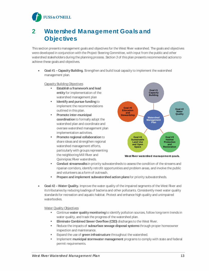
2 Watershed Management Goals andObjectives
This section presents management goals and objectives for the West River watershed. The goals and objectiveswere developed in conjunction with the Project Steering Committee, with input from the public and otherwatershed stakeholders during the planning process. Section 3 of this plan presents recommended actions toachieve these goals and objectives.
· Goal #1 – Capacity Building. Strengthen and build local capacity to implement the watershedmanagement plan.
Capacity Building Objectives§ Establish a framework and lead
entity for implementation of thewatershed management plan
§ Identify and pursue funding toimplement the recommendationsoutlined in this plan.
§ Promote inter-municipalcoordination to formally adopt thewatershed plan and coordinate andoversee watershed management planimplementation activities.
§ Promote regional collaboration toshare ideas and strengthen regionalwatershed management efforts,particularly with groups representingthe neighboring Mill River andQuinnipiac River watersheds.
§ Conduct streamwalks in priority subwatersheds to assess the condition of the streams andriparian corridors, identify retrofit opportunities and problem areas, and involve the publicand volunteers as a form of outreach.
§ Prepare and implement subwatershed action plans for priority subwatersheds.
· Goal #2 – Water Quality. Improve the water quality of the impaired segments of the West River andits tributaries by reducing loadings of bacteria and other pollutants. Consistently meet water qualitystandards for recreation and aquatic habitat. Protect and enhance high quality and unimpairedwaterbodies.
Water Quality Objectives§ Continue water quality monitoring to identify pollution sources, follow long-term trends in
water quality, and track the progress of the watershed plan.§ Eliminate Combined Sewer Overflow (CSO) discharges to the West River.§ Reduce the impacts of subsurface sewage disposal systems through proper homeowner
inspection and maintenance.§ Expand the use of green infrastructure throughout the watershed.§ Implement municipal stormwater management programs to comply with state and federal
permit requirements.
WatershedManagement
Plan
Goal #1CapacityBuilding
Goal #2Water
Quality
Goal #3Habitat
Protectionand
Restoration
Goal #4SustainableLand Useand Open
Space
Goal #5Education
andStewardship
West River watershed management goals.
West River Watershed Management Plan 14
§ Protect and restore natural streamside vegetation in the watershed to protect and improvewater quality.
§ Reduce bacteria loads from wildlife and pet waste.§ Identify and remove illicit connections and non-stormwater discharges to the West River
and its tributaries.§ Promote sustainable lawn care practices to reduce the use of water, fertilizer, and toxic
chemicals.§ Reduce the threats to water quality from commercial and industrial land uses.§ Protect public drinking water supplies in the upper watershed through ongoing source
water protection and open space acquisition.
· Goal #3 – Habitat Protection and Restoration. Protect and restore terrestrial, streamside, and aquatichabitat.
Habitat Objectives§ Protect and restore in-stream habitat for resident and migratory fish species in the West
River and portions of Wintergreen Brook by removing barriers to fish passage.§ Protect and restore natural vegetated buffers along the West River, its tributaries, and other
water bodies.§ Protect and restore high-priority wetland and open water habitat including the West River
Tidal Marsh and reflecting pool, Pond Lily, Konolds Pond, and Beaver Ponds.§ Manage invasive plant species that threaten local biodiversity and ecosystem function in the
watershed.§ Protect and restore forested areas and tree canopy within the watershed.
· Goal #4 – Sustainable Land Use, Open Space, and Public Access. Promote sustainable land use andappropriate development in the watershed while protecting and improving water quality and naturalresources, enhancing public access to and connectivity of waterbodies and open space, andaddressing current and future flooding problems.
Land Use, Open Space, and Public Access Objectives§ Preserve existing open space and prioritize additional lands for open space conservation.§ Increase public access to and connectivity of water bodies and open space to improve
public use, appreciation, and stewardship.§ Strengthen municipal land use policy and regulations for broader implementation of low
impact development and green infrastructure.§ Increase flood resilience through a watershed approach.
· Goal #5 – Education and Stewardship. Promote stewardship of the watershed through education andoutreach, improved access to the West River and its tributaries, and citizen involvement in science,conservation, and restoration activities.
West River Watershed Management Plan 15
Education and Stewardship Objectives§ Implement a green infrastructure public outreach campaign focused on citizens,
businesses, and communities.§ Provide incentives for residential “green” practices.§ Conduct homeowner education and outreach on animal waste, sustainable lawn care and
landscaping practices, streamside buffers, and septic system maintenance.§ Promote, publicize, and support existing community engagement events that focus on the
West River and its watershed such as the annual “West River Water Festival”.§ Conduct education and outreach for the watershed business community on pollution
prevention.§ Conduct municipal education and outreach on animal waste, parks and open space
maintenance, green infrastructure, storm sewer system and BMP maintenance, andidentification and removal of illicit connections.
§ Enhance youth education, community service, and environmental stewardship programs.§ Conduct outreach to public and private institutional property owners in the watershed
such as Yale University, Southern Connecticut State University, University of New Haven, andothers.
§ Increase watershed stewardship signage in targeted areas.§ Address homeless encampments near the West River through support of City shelters and
services to reduce homelessness, periodic cleanups, providing public restrooms, andpartnering with non-governmental organizations to address homelessness.

West River Watershed Management Plan 16
3 Management RecommendationsThis section describes recommended actions to meet the watershed management goals and objectivesoutlined in Section 2. The recommendations include watershed-wide and targeted actions:
· Watershed-wide Recommendations are recommendations that can be implemented throughout theWest River watershed. These basic measures can be implemented in most areas of the watershed andare intended to address nonpoint source pollution. The water quality benefits of these measures areprimarily long-term and cumulative in nature resulting from runoff reduction, source control,pollution prevention, and improved stormwater management.
· Targeted Recommendations include site-specific projects and/or actions intended to address issueswithin specific subwatersheds or areas, rather than watershed-wide. Targeted recommendations alsoinclude actions to address common types of problems that are identified at representative locationsthroughout the watershed, but where additional field assessments or evaluations are required todevelop site-specific recommendations. Targeted recommendations can have both short and long-term benefits.
Due to the large size of the West River watershed and limited field assessment scope of the watershedplanning process, additional field assessments are recommended to further characterize pollutant sources andpotential site-specific restoration projects. An objective of the proposed stream assessments is to help identifyadditional site-specific projects and develop action plans for targeted subwatersheds, which is more effectiveat the subwatershed scale.
The recommendations presented in this section are classified according to their timeframe andimplementation priority. Recommendations include ongoing, short-term, mid-term, and long-term actions:
· Ongoing Actions are actions that occur annually or more frequently such as routine water qualitymonitoring, fundraising, and education and outreach.
· Short-Term Actions are initial actions to be accomplished within the first two years of planimplementation. These actions have the potential to demonstrate immediate progress and successand/or help establish the framework for implementing subsequent plan recommendations.
· Mid-Term Actions involve continued programmatic and operational measures, delivery ofeducational and outreach materials, and construction of larger retrofit and/or restoration projectsbetween two and five years after plan adoption.
· Long-Term Actions consist of continued implementation of watershed projects, as well as anevaluation of progress, accounting of successes and lessons learned, and an update of the watershedmanagement plan. Long-term actions are intended to be completed between 5 and 10 years or longerafter plan adoption. The feasibility of long-term actions, many of which involve significantinfrastructure improvements, depends upon the availability of sustainable funding programs andmechanisms.
The remainder of this section describes the recommended actions presented in this watershed managementplan. The recommended actions are categorized according to the five major goals of this plan – (1) capacitybuilding, (2) water quality, (3) habitat protection and restoration, (4) sustainable land use, open space, andpublic access, and (5) education and stewardship.
West River Watershed Management Plan 17
Goal Statement: Strengthen and build local capacity to implement the watershed management plan.
3.1 Capacity Building
The success of this watershed plan will depend on effective leadership, active participation by the watershedstakeholders, and local “buy-in” of the plan recommendations by the watershed municipalities, in addition tofunding and technical assistance. Fortunately, significant local support and “capacity” for watershed protectionand restoration already exists within the West River Watershed, led by the West River Watershed Coalition andother stakeholder groups. Strengthening local capacity for implementing this watershed plan, by building onthe existing network of volunteers and programs, is a critical early and ongoing part of the watershed planimplementation process. Table 3-1 summarizes Capacity Building recommendations, which are describedbelow in greater detail.
3.1.1 Establish a Framework and LeadEntity
Recommended Actions· The West River Watershed Coalition has limited capacity to implement the watershed plan without a
funded watershed coordinator position. Secure funding for and hire a watershed coordinator to assistthe WRWC and to lead watershed management plan implementation activities such as:
o Coordinating the efforts of plan implementation sub-committeeso Identifying funding sources, as well as pursuing grant funding for projectso Periodically reviewing and updating action items in the plano Developing annual work plans (i.e., specific “to-do” lists)o Coordinating and leading public outreach activitieso Hosting public meetings to celebrate accomplishments, recognize participants, review
lessons learned, and solicit feedback on plan updates and next steps.
An example of a funded watershed coordinator position is the Niantic River Watershed Coordinator,which has been funded through a series of Section 319 Nonpoint Source Pollution program grantsawarded to the Eastern Connecticut Conservation District.
· Form watershed plan implementation sub-committees around the watershed plan goals – waterquality, habitat restoration, land use/open space, and education/outreach. The sub-committeeswould ideally consist of volunteers with a particular interest or area of expertise in each topic.
· Hold regular meetings/forums for citizen input.
· Create and maintain a website dedicated to the West River watershed to serve as a centralized sourceof information on the watershed and management plan implementation activities.
3.1.2 Promote Inter-MunicipalCoordination
Many of the recommendations in this watershed management plan can benefit from a partnership among thewatershed municipalities. For example, applying jointly for grants to fund the implementation of theseactivities allows the sharing of grant-writing assistance, and the leveraging of match and in-kind services.

West River Watershed Management Plan 18
Table 3-1. Capacity Building Recommendations
Actions Who Timeframe Products/Evaluation Criteria
EstimatedCosts
Potential FundingSources
1. Secure funding for and hire a watershedcoordinator
WRWC, STS,SWCD
0-2 years Funded watershedcoordinator position
$$$ Grants
2. Form watershed plan implementation sub-committees or work groups· Recruit members· Develop work plans· Hold regular forums for citizen input
WRWC 0-2 years Committee membershipand work plans
$ Grants
3. Create and maintain a West River watershedwebsite
WRWC andconsultant
0-2 years Dedicated website $$$ Grants
4. Obtain municipal endorsement of thewatershed plan
STS and WRWC 0-2 years Memorandum ofAgreement (MOA), inter-municipal agreement,compact or similarmechanism
$
5. Engage and involve local, state, and regionalorganizations. Promote grassrootsinvolvement.
WRWC andgroups listed inTable 3-2
Ongoing Active participation inwatershed plan activitiesby organizations
$
6. Identify and pursue funding· Review and prioritize funding sources· Prepare and submit grant applications
STS and WRWC 0-2 yearsOngoing
List of funding sources andfunding pursued
$$ See Section 5 andAppendix H of thisplan for fundingsources
7. Conduct streamwalk assessments· Complete streamwalks· Compile and analyze data· Plan and conduct “track down” surveys
STS andvolunteers
0-2 years(repeatstreamwalksevery 5 yrs)
Streamwalk assessmentand track down surveyfindings andrecommendations
$$
8. Prepare and implement subwatershed actionplans
WRWC andconsultant
0-2 years Subwatershed action plansprepared and implemented
$$$
$ = $0 to $5,000 $$ = $5,000 to $10,000 $$$ = $10,000 to $50,000 $$$$ = Greater than $50,000
STS = Save the Sound/Connecticut Fund for the Environment WRWC = West River Watershed Coalition SWCD = Southwest Conservation District
West River Watershed Management Plan 19
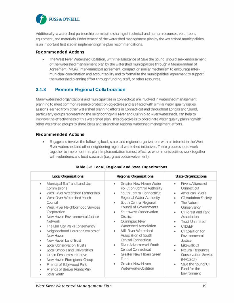
Additionally, a watershed partnership permits the sharing of technical and human resources, volunteers,equipment, and materials. Endorsement of the watershed management plan by the watershed municipalitiesis an important first step in implementing the plan recommendations.
Recommended Actions· The West River Watershed Coalition, with the assistance of Save the Sound, should seek endorsement
of the watershed management plan by the watershed municipalities through a Memorandum ofAgreement (MOA), inter-municipal agreement, compact or similar mechanism to encourage inter-municipal coordination and accountability and to formalize the municipalities’ agreement to supportthe watershed planning effort through funding, staff, or other resources.
3.1.3 Promote Regional Collaboration
Many watershed organizations and municipalities in Connecticut are involved in watershed managementplanning to meet common resource protection objectives and are faced with similar water quality issues.Lessons learned from other watershed planning efforts in Connecticut and throughout Long Island Sound,particularly groups representing the neighboring Mill River and Quinnipiac River watersheds, can help toimprove the effectiveness of this watershed plan. This objective is to coordinate water quality planning withother watershed groups to share ideas and strengthen regional watershed management efforts.
Recommended Actions· Engage and involve the following local, state, and regional organizations with an interest in the West
River watershed and other neighboring regional watershed initiatives. These groups should worktogether to implement this plan. Implementation is most effective when municipalities work togetherwith volunteers and local stewards (i.e., grassroots involvement).
Table 3-2. Local, Regional and State Organizations
Local Organizations Regional Organizations State Organizations
· Municipal Staff and Land UseCommissions
· West River Watershed Partnership· West River Watershed Youth
Council· West River Neighborhood Services
Corporation· New Haven Environmental Justice
Network· The Elm City Parks Conservancy· Neighborhood Housing Services of
New Haven· New Haven Land Trust· Local Conservation Trusts· Local Schools and Universities· Urban Resources Initiative· New Haven Bioregional Group· Friends of Edgewood Park· Friends of Beaver Ponds Park· Solar Youth
· Greater New Haven WaterPollution Control Authority
· South Central ConnecticutRegional Water Authority
· South Central RegionalCouncil of Governments
· Southwest ConservationDistrict
· Quinnipiac RiverWatershed Association
· Mill River WatershedAssociation of SouthCentral Connecticut
· River Advocates of SouthCentral Connecticut
· Greater New Haven GreenFund
· Greater New HavenWaterworks Coalition
· Rivers Alliance ofConnecticut
· American Rivers· CT Audubon Society· The Nature
Conservancy· CT Forest and Park
Association· Trout Unlimited· CTDEEP· CT Coalition for
EnvironmentalJustice
· Bikewalk CT· Natural Resources
Conservation Service(NRCS-CT)
· Save the Sound/CTFund for theEnvironment
West River Watershed Management Plan 20
3.1.4 Identify and Pursue Funding
Many actions in this plan are only achievable with sufficient funding and staffing. A variety of fundingopportunities should be pursued to implement the recommendations outlined in this plan.
Recommended Actions· Review and prioritize potential funding sources that have been preliminarily identified in this
watershed plan (see Section 6). High-priority funding sources that should be considered include:o CTDEEP/EPA Section 319 Nonpoint Source Grantso National Fish and Wildlife Foundation Long Island Sound Futures Fundo Connecticut Clean Water Fundo HUD Community Development Block Grants for green infrastructure and coastal resilienceo Community Foundation for Greater New Haveno Stormwater utilities and other innovative stormwater program financing mechanisms
· Prepare and submit grant applications for projects identified in this plan on an ongoing basis.· Pursue funding for ongoing, long-term water quality monitoring within the watershed.· Advocate for state and federal funding, working jointly with other watershed organizations in the
region and state.· Explore EPA designation of the West River, Mill River, and Quinnipiac River watersheds (i.e., “Greater
New Haven Watershed”) as an eligible geographic location (co-located with 18 existing Urban WatersFederal Partnership locations nation-wide) under the EPA Urban Waters Small Grants program. Atsome point in the future, eligible geographic location/Federal Partnership designation will be re-evaluated by EPA.
3.1.5 Conduct Streamwalk Assessments
Visual stream assessments or streamwalks are a simplified assessment protocol to evaluate the condition ofaquatic ecosystems associated with streams. They help to evaluate the overall condition of the stream, riparianbuffer, and floodplain based on a consideration of in-stream habitat, vegetative protection, bank erosion,floodplain connection, vegetated buffer width, floodplain vegetation and habitat, and floodplainencroachment. Visual stream assessments also help to identify problem areas and provide a basis for furtherdetailed field investigation and potential restoration opportunities. Streamwalks also provide an idealopportunity to involve the public and volunteers as a form of outreach.
Fuss & O’Neill and staff from the Connecticut office of the Natural Resources Conservation Service (NRCS)conducted streamwalk assessment training on June 22, 2015 for Save the Sound, members of the West RiverWatershed Coalition, and other volunteers. The classroom and field training provided information onconducting stream assessments of the West River and its tributaries following the NRCS protocols forperforming visual stream assessments in Connecticuthttp://www.nrcs.usda.gov/wps/portal/nrcs/detail/ct/water/?cid=nrcs142p2_011198.
Appendix F of this plan contains materials from the streamwalk assessment training.
West River Watershed Management Plan 21
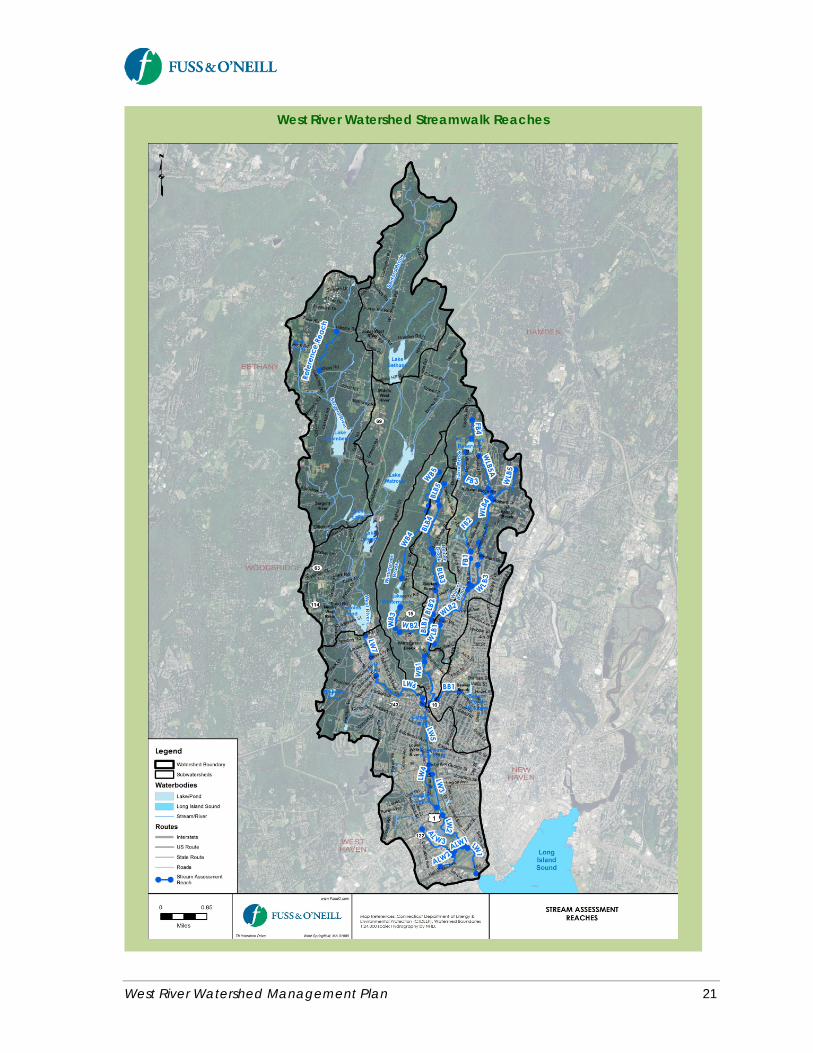
West River Watershed Streamwalk Reaches
West River Watershed Management Plan 22
Save the Sound, members of the West River Watershed Coalition, students and faculty from the CommonGround School, and other volunteers conducted streamwalk assessments of selected reaches of the West Riverand its tributaries during the summer of 2015. The selected reaches are primarily within the lower impairedsections of the West River and Wintergreen Brook subwatersheds. A reach on the Sargent River withdocumented high-quality water is also included as a reference reach for comparison. Initial results from thestreamwalks are presented in Appendix F.
Recommended Actions· Complete streamwalk assessment surveys of all selected reaches in the watershed using the
Connecticut NRCS protocols and field data collection sheets.· Compile and analyze the collected data.· Following the streamwalks and evaluation of the assessment results, plan and conduct subwatershed
visual “track down” surveys of identified or suspected pollution sources. Visual track down surveysare a tool commonly used by the Connecticut Conservation Districts to help identify conditionsresponsible for water quality impairments in streams. The goals of the track down survey are tocollect information on the possible causes of impairment and recommend and implement solutions toaddress the identified issues of concern.
· Subwatershed stream assessments and track down surveys should be updated every five to ten yearsto monitor changing watershed conditions and the progress of plan implementation.
3.1.6 Prepare and ImplementSubwatershed Action Plans
Development and implementation of site-specific restoration and protection strategies is most effective at thesubwatershed scale for larger watersheds such as the West River watershed. Although this watershed planidentifies a number of site-specific recommendations and green infrastructure concepts that are examples ofthe types of projects that could be implemented elsewhere in the watershed, the limited scope of thiswatershed planning effort did not allow for comprehensive field assessments of the West River and its entirewatershed. Additional targeted watershed assessment and planning is recommended for varioussubwatersheds, including streamwalk assessments, track down surveys, and volunteer monitoring. Theseadditional assessments will help to better characterize current conditions within specific reaches of the WestRiver, its tributaries, and upland areas of the subwatersheds. The goal of the streamwalks and track downsurveys is to develop action plans for each priority subwatershed and identify additional site-specificrestoration projects.
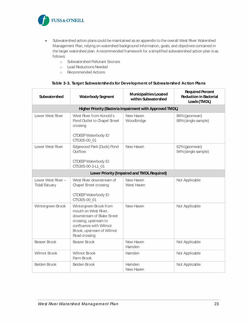
Recommended Actions· Prepare and implement more detailed subwatershed action plans for priority subwatersheds based on
the findings of streamwalk assessments and associated track down surveys (see recommendations inprevious section).
· Target subwatersheds, including major tributaries and municipalities located within eachsubwatershed, are summarized in Table 3-3. The municipalities located within each subwatershedshould be encouraged to participate in development and implementation of the respectivesubwatershed action plans. Table 3-3 also includes the average percent reductions in bacterial loadsto meet water quality standards, as reported in the statewide bacteria TMDL for the West River.Higher priority subwatersheds are those watersheds containing water bodies with bacterialimpairments listed in the TMDL. Lower priority subwatersheds include other West River tributarieswith listed water quality impairments, but for which a TMDL has not yet been developed.
West River Watershed Management Plan 23
· Subwatershed action plans could be maintained as an appendix to the overall West River WatershedManagement Plan, relying on watershed background information, goals, and objectives contained inthe larger watershed plan. A recommended framework for a simplified subwatershed action plan is asfollows:
o Subwatershed Pollutant Sourceso Load Reductions Neededo Recommended Actions
Table 3-3. Target Subwatersheds for Development of Subwatershed Action Plans
Subwatershed Waterbody Segment Municipalities Locatedwithin Subwatershed
Required PercentReduction in Bacterial
Loads (TMDL)
Higher Priority (Bacteria Impairment with Approved TMDL)
Lower West River West River from Konold’sPond Outlet to Chapel Streetcrossing
CTDEEP Waterbody IDCT5305-00_01
New HavenWoodbridge
86% (geomean)88% (single sample)
Lower West River Edgewood Park (Duck) PondOutflow
CTDEEP Waterbody IDCT5305-00-3-L1_01
New Haven 62% (geomean)94% (single sample)
Lower Priority (Impaired and TMDL Required)
Lower West River –Tidal/Estuary
West River downstream ofChapel Street crossing
CTDEEP Waterbody IDCT5305-00_01
New HavenWest Haven
Not Applicable
Wintergreen Brook Wintergreen Brook frommouth on West River,downstream of Blake Streetcrossing, upstream toconfluence with WilmotBrook, upstream of WilmotRoad crossing
New Haven Not Applicable
Beaver Brook Beaver Brook New HavenHamden
Not Applicable
Wilmot Brook Wilmot BrookFarm Brook
Hamden Not Applicable
Belden Brook Belden Brook HamdenNew Haven
Not Applicable
West River Watershed Management Plan 24
Goal Statement: Improve the water quality of the impaired segments of the West River and its tributaries by reducingloadings of bacteria and other pollutants. Consistently meet water quality standards for recreation and aquatic habitat.Protect and enhance high quality and unimpaired waterbodies.
3.2 Water Quality
3.2.1 Water Quality Monitoring
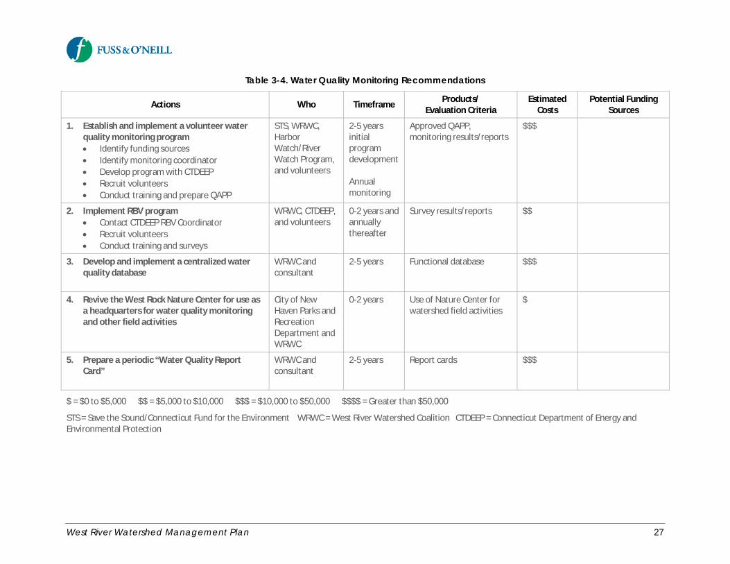
Ongoing water quality monitoring is recommended for the West River watershed to refine the understandingof water quality impacts from potential point and non-point pollution sources in the watershed, to measurethe progress toward meeting watershed management goals and TMDL pollutant load reductions, andultimately support removal of the impaired segments of the West River and its tributaries from the CTDEEPimpaired waters list. Water quality monitoring recommendations are summarized in Table 3-4.
Recommended Actions· Consider establishing a volunteer water quality monitoring program for the West River. Volunteer
monitoring promotes citizen awareness, involvement, and environmental stewardship. Volunteermonitoring can also help to identify ambient water quality and trends, fill in gaps in statewidemonitoring data, and provides data for regulatory and land use decision-making. Many examples ofsuccessful volunteer monitoring programs exist around Long Island Sound. Additional informationabout the CTDEEP Volunteer Monitoring Program is available online athttp://www.ct.gov/deep/streamvolmon.
· Consistent with the bacteria TMDL for the West River watershed, the monitoring program should bedesigned to accomplish two objectives: (1) source detection to identify specific sources of bacterialloading and (2) fixed station monitoring to track water quality improvements.
o Bacteria Source Detection – Source detection monitoring may include visual inspection ofstorm sewer outfalls under dry weather conditions, event sampling of individual storm seweroutfalls, and monitoring of ambient (in-stream) conditions at closely spaced intervals toidentify “hot spots” for more detailed investigations leading to specific sources of highbacteria loads. Source detection monitoring should be informed by the findings ofstreamwalk assessments and follow-up track down surveys. Source detection monitoringshould also be implemented by the watershed municipalities as part of their “Illicit DischargeDetection and Elimination” efforts as required by the MS4 permit.
o Fixed Station Bacteria Monitoring – Conduct routine bacteria monitoring at fixed sites alongthe impaired reaches of West River (and the Edgewood Park Pond outflow) and WintergreenBrook to measure progress toward achieving the watershed plan and TMDL pollutant loadreduction goals. Sampling should be scheduled at regularly spaced intervals during therecreational season. Therefore, the data set at the end of each season would include ambientvalues for both “wet” and “dry” conditions in relative proportion to the number of “wet” and“dry” days that occurred during the monitoring period. The TMDL calculations can beupdated over time to compare the percent reductions needed under “dry” and “wet”conditions to the percent reductions that were needed at the time of TMDL adoption.
West River Watershed Management Plan 25
· Also consider implementing the Riffle Bioassessment by Volunteers (RBV) Program within the WestRiver watershed. The RBV program is a volunteer water quality monitoring protocol developed andadministered by the CTDEEP. Volunteers are trained to assess benthic macroinvertebrates in smallwadeable streams to screen local stream segments for water quality. Volunteers could includestudents and faculty from local schools and universities. The non-tidal portions of the West River andboth impaired and unimpaired segments of its major tributaries are potential candidates for RBVsurveys. Information on the RBV Program is available at http://www.ct.gov/deep/rbv.
· Develop and implement a centralized water quality database for historical and new water qualitymonitoring data for the West River watershed. The database could be made accessible to the WestRiver Watershed Coalition, educational groups for teaching purposes, and the general public. Thedatabase could be implemented using an existing tool such as the Global Learning and Observationsto Benefit the Environment (GLOBE) Program https://www.globe.gov/home, which is an internationalscience and education program that provides students and the public worldwide with the opportunityto participate in data collection, data entry, and data visualization, or a custom software applicationsuch as the recently developed water quality database and web resource for the Bronx Riverhttp://bronxriverwater.org/.
· Pursue dedicated funding to finance future monitoring and reporting.
· Revive the inactive West Rock Nature Center for use as a headquarters for water quality monitoring,stream surveys, and other field-related and restoration activities in the West River watershed.
· Prepare a periodic “Water Quality Report Card” for the West River modeled after similar report cardsthat have been prepared for other rivers and embayments around Long Island Sound and elsewhere inthe U.S. The report card would provide a transparent, timely, and geographically detailed assessmentof water quality for the West River to inform the public of water quality conditions and actions thatare occurring to improve and protect water quality in the river. Report card scores are determined bycomparing water quality indicators to scientifically-derived ecological thresholds or goals.
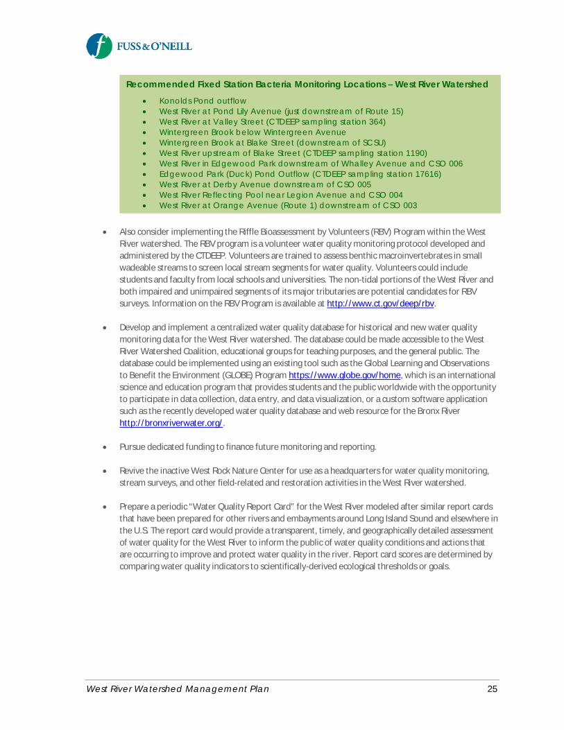
Recommended Fixed Station Bacteria Monitoring Locations – West River Watershed· Konolds Pond outflow· West River at Pond Lily Avenue (just downstream of Route 15)· West River at Valley Street (CTDEEP sampling station 364)· Wintergreen Brook below Wintergreen Avenue· Wintergreen Brook at Blake Street (downstream of SCSU)· West River upstream of Blake Street (CTDEEP sampling station 1190)· West River in Edgewood Park downstream of Whalley Avenue and CSO 006· Edgewood Park (Duck) Pond Outflow (CTDEEP sampling station 17616)· West River at Derby Avenue downstream of CSO 005· West River Reflecting Pool near Legion Avenue and CSO 004· West River at Orange Avenue (Route 1) downstream of CSO 003

West River Watershed Management Plan 26
Water Quality Report CardAn example of a water quality report card developed for HempsteadHarbor on the north shore of Long Island.http://www.nfwf.org/whoweare/mediacenter/pr/Documents/hempstead-harbor-report-card.pdf
West River Watershed Management Plan 27
Table 3-4. Water Quality Monitoring Recommendations
Actions Who Timeframe Products/Evaluation Criteria
EstimatedCosts
Potential FundingSources
1. Establish and implement a volunteer waterquality monitoring program· Identify funding sources· Identify monitoring coordinator· Develop program with CTDEEP· Recruit volunteers· Conduct training and prepare QAPP
STS, WRWC,HarborWatch/RiverWatch Program,and volunteers
2-5 yearsinitialprogramdevelopment
Annualmonitoring
Approved QAPP,monitoring results/reports
$$$
2. Implement RBV program· Contact CTDEEP RBV Coordinator· Recruit volunteers· Conduct training and surveys
WRWC, CTDEEP,and volunteers
0-2 years andannuallythereafter
Survey results/reports $$
3. Develop and implement a centralized waterquality database
WRWC andconsultant
2-5 years Functional database $$$
4. Revive the West Rock Nature Center for use asa headquarters for water quality monitoringand other field activities
City of NewHaven Parks andRecreationDepartment andWRWC
0-2 years Use of Nature Center forwatershed field activities
$
5. Prepare a periodic “Water Quality ReportCard”
WRWC andconsultant
2-5 years Report cards $$$
$ = $0 to $5,000 $$ = $5,000 to $10,000 $$$ = $10,000 to $50,000 $$$$ = Greater than $50,000
STS = Save the Sound/Connecticut Fund for the Environment WRWC = West River Watershed Coalition CTDEEP = Connecticut Department of Energy andEnvironmental Protection
West River Watershed Management Plan 28
3.2.2 Combined Sewer Overflows
As described in West River Watershed Management Plan, Technical Memorandum #1: State of the Watershed(Fuss & O’Neill, 2015a), during wet weather portions of the combined sanitary and storm sewer system in theCity of New Haven become overwhelmed and combined sewage overflows to nearby receiving waters. Thesedischarges are referred to as Combined Sewer Overflows (CSOs). There are four permitted CSO outfalls to theWest River – CSOs 003, 004, 005, and 006. The Greater New Haven Water Pollution Control Authority(GNHWPCA) is in the process of implementing a phased plan to reduce CSOs to the West River, which includestraditional gray infrastructure and green infrastructure approaches.
GNHWPCA should continue to implement CSO abatement measures to further reduce CSO discharges to theWest River consistent with its CSO abatement plan. Specific CSO-related recommendations are describedbelow and summarized in Table 3-5.
Recommended Actions· Complete the CSO wet weather capacity improvements in the West River watershed that are
identified in the 2014 West River CSO Abatement Report (CH2MHILL, 2014a) and 2014 HydraulicModel Update Report (CH2MHILL, 2015), including but not limited to:
o Raising the overflow weir at Regulators 004 and 005 (completed in 2014)o Making improvements to the Truman CSO Storage Tank (completed in 2015)o Cleaning the lower Boulevard Trunk Sewero Maximizing pumping from the Boulevard Pump Stationo Relocating Regulator 003 off of Ella Grasso Boulevard and constructing a new mechanically
controlled adjustable weir at a higher elevationo Relocating Regulator 004 off of Ella Grasso Boulevard and constructing a new mechanically
controlled adjustable weir at a higher elevationo Modifying Regulator 006 by constructing a new access chamber and installing stop logs at a
higher elevation.
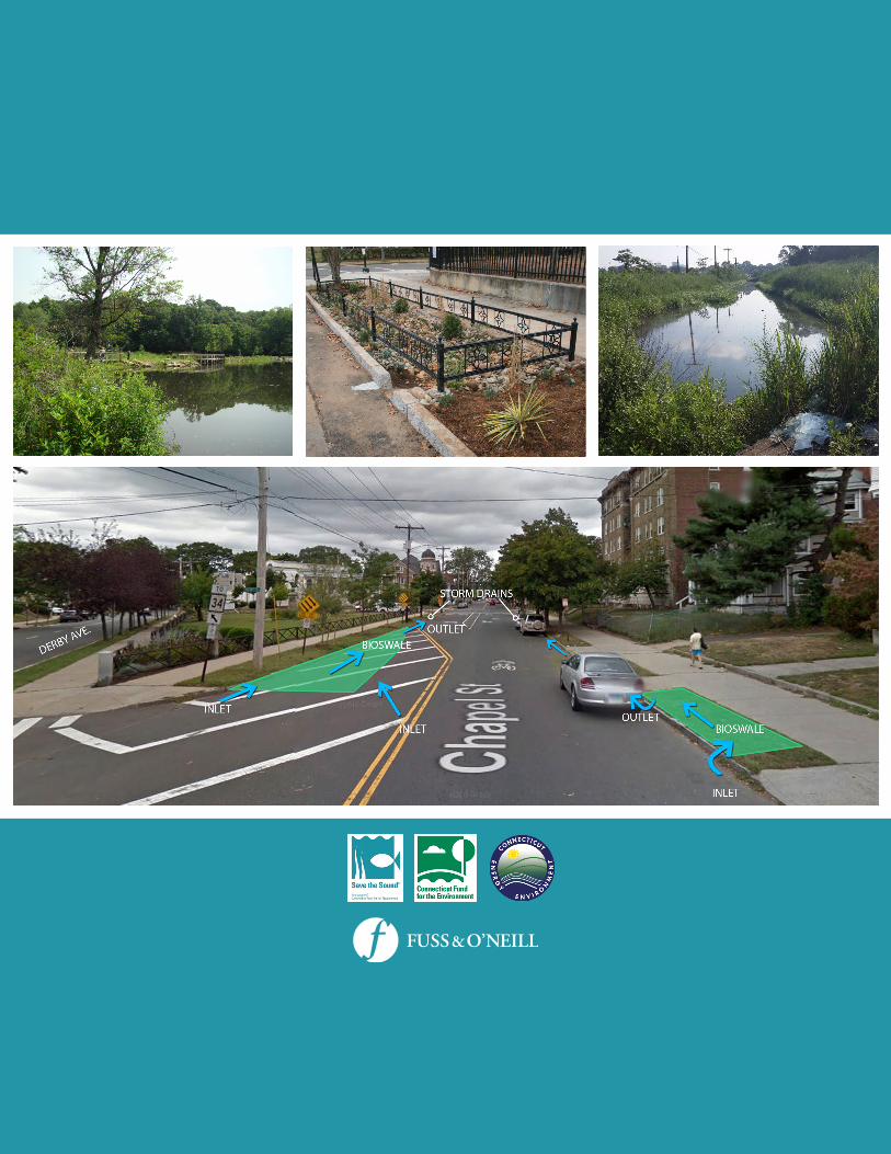
· Implement green infrastructure projects within the Boulevard Trunk Sewer tributary areas (CSOsewersheds 003 and 004), as identified in the Green Infrastructure Suitability Pilot Study (GreenInfrastructure Improvement Report) completed in August 2014 (CH2MHILL, 2014b).
· Update and implement the CSO Long Term Control Plan (2016 Update), which will identify anddevelop short, intermediate and long term CSO control measures to achieve zero discharges from CSOoutfalls for up to a 2-year, 6-hour rainfall event by 2036.
· Continue to require the use of green infrastructure stormwater management practices (e.g.,infiltrators and drywells, rain water storage tanks, bioswales and tree wells, water features) fordevelopment projects within combined sewer areas in accordance with the GNHWPCA Permitting andDesign Criteria Manual (retain runoff on-site for the 2-year, 6-hour rainfall event, or approximately2.05 inches).
· Continue to collect flow monitoring data to evaluate the effectiveness of the ongoing CSOimprovements in the West River watershed (i.e., CSO events, volumes, and pollutant loads)
· Compare annual measured CSO volumes with the annual CSO volume predicted by the December2014 hydraulic model update (14.65 million gallons). Several years of monitoring data may be neededto adequately characterize annual CSO discharges under a variety of wet weather conditions.
West River Watershed Management Plan 29
· Foster a partnership between the GNHWPCA and the Greater New Haven Waterworks Coalition tohelp promote green infrastructure within the GHNWPCA service areas with combined sewers. TheGreater New Haven Waterworks Coalition would have a role in helping to establish success measuresand provide some oversight and reporting back to the community.
3.2.3 Green Infrastructure and Low ImpactDevelopment
Urban stormwater runoff is a significant source of pollutants and a leading cause of water quality impairmentsin the West River. Stormwater runoff from developed areas and other nonpoint sources of pollution in thewatershed are major contributors of bacteria, sediment, and nutrients. As discussed previously, CSOs are also amajor source of pollutants to the West River during wet weather.
Green infrastructure (GI) refers to systems and practices thatreduce runoff through the use vegetation, soils, and naturalprocesses to manage water and create healthier urban andsuburban environments (EPA, 2014). When applied to sites orneighborhoods, green infrastructure includes stormwatermanagement practices such as rain gardens, permeablepavement, green and blue roofs, green streets, infiltrationplanters, trees and tree boxes, and rainwater harvesting. Thesepractices capture, manage, and/or reuse rainfall close to where itfalls, thereby reducing stormwater runoff and keeping it out ofreceiving waters.
In addition to reducing polluted runoff and improving waterquality, GI has been shown to provide other social and economicbenefits relative to reduced energy consumption, improved airquality, carbon reduction and sequestration, improved propertyvalues, recreational opportunities, overall economic vitality, andadaptation to climate change (Center for NeighborhoodTechnology and American Rivers, 2010; EPA Green Infrastructure Websitehttp://water.epa.gov/infrastructure/greeninfrastructure/gi_why.cfm). For these reasons, many communitiesare exploring the use of and are adopting GI within their municipal infrastructure programs.
As described in Technical Memorandum #1: State of the Watershed (Fuss & O’Neill, 2015a), GI is beingimplemented by the City of New Haven, GNHWPCA, private development, and other groups working in theWest River watershed. An important objective of the West River Watershed Management Plan is to reduce CSOdischarges, runoff volumes, and pollutant loads through the use of GI by building on the previous and ongoingGI initiatives in the watershed and region. Additional opportunities for GI retrofits in the West River watershedwere identified during the development of this watershed plan and are documented in TechnicalMemorandum #2: Low Impact Development and Green Infrastructure Assessment (Fuss & O’Neill, 2015b).Table 3-5 contains green infrastructure recommendations for the West River watershed.
Green Infrastructure (GI) can bedefined as the natural and man-madelandscapes and features that can beused to manage runoff. Examples ofnatural green infrastructure includeforests, meadows and floodplains.Examples of man-made greeninfrastructure include green roofs, raingardens and rainwater cisterns.
Low Impact Development (LID) is aland development approach that isintended to reduce developmentrelated impacts on water resourcesthrough the use of stormwatermanagement practices that infiltrate,evapotranspirate, or harvest and usestormwater on the site where it falls.
West River Watershed Management Plan 30
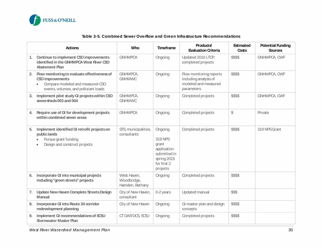
Table 3-5. Combined Sewer Overflow and Green Infrastructure Recommendations
Actions Who Timeframe Products/Evaluation Criteria
EstimatedCosts
Potential FundingSources
1. Continue to implement CSO improvementsidentified in the GNHWPCA West River CSOAbatement Plan
GNHWPCA Ongoing Updated 2016 LTCP,completed projects
$$$$ GNHWPCA, CWF
2. Flow monitoring to evaluate effectiveness ofCSO improvements· Compare modeled and measured CSO
events, volumes, and pollutant loads
GNHWPCA,GNHWWC
Ongoing Flow monitoring reportsincluding analysis ofmodeled and measuredparameters
$$$$ GNHWPCA, CWF
3. Implement pilot study GI projects within CSOsewersheds 003 and 004
GNHWPCA,GNHWWC
Ongoing Completed projects $$$$ GNHWPCA, CWF
4. Require use of GI for development projectswithin combined sewer areas
GNHWPCA Ongoing Completed projects $ Private
5. Implement identified GI retrofit projects onpublic lands· Pursue grant funding· Design and construct projects
STS, municipalities,consultants
Ongoing
319 NPSgrantapplicationsubmitted inspring 2015for first 2projects
Completed projects $$$$ 319 NPS Grant
6. Incorporate GI into municipal projectsincluding “green streets” projects
West Haven,Woodbridge,Hamden, Bethany
Ongoing Completed projects $$$$
7. Update New Haven Complete Streets DesignManual
City of New Haven,consultant
0-2 years Updated manual $$$
8. Incorporate GI into Route 34 corridorredevelopment planning
City of New Haven Ongoing GI master plan and designconcepts
$$$$
9. Implement GI recommendations of SCSUStormwater Master Plan
CT DAS/DCS, SCSU Ongoing Completed projects $$$$

West River Watershed Management Plan 31
Table 3-5. Combined Sewer Overflow and Green Infrastructure Recommendations
Actions Who Timeframe Products/Evaluation Criteria
EstimatedCosts
Potential FundingSources
10. Evaluate and modify existing municipal landuse regulations and policy to require the useof GI and LID for development projects· Conduct land use regulatory review· Implement recommendations of land use
regulatory review
UConn NEMO(regulatory review)
Municipalities,consultants(implementrecommendations)
0-2 years
2-5 years
Final project report
Amendments to local landuse regulations andpolicies
$$$$
$$$$
Long Island SoundStudy
NFWF Long IslandSound Futures Fund,CTDEEPSupplementalEnvironmentalProject Funds, 319NPS Grants
11. Pursue sustainable, long-term funding sourcesfor large-scale GI implementation
Regionalcollaboration ofSTS, SCRCOG,GNHWPCA,Municipalities
5-10 years Framework and actionplan to evaluate andimplement stormwaterinfrastructure financing
$$$$ Stormwater utilities,property tax creditsand incentive ratestructures, greenbonds, public privatepartnerships, CWF
$ = $0 to $5,000 $$ = $5,000 to $10,000 $$$ = $10,000 to $50,000 $$$$ = Greater than $50,000
GNHWPCA = Greater New Haven Water Pollution Control Authority STS = Save the Sound/Connecticut Fund for the Environment CTDEEP = ConnecticutDepartment of Energy and Environmental Protection SCRCOG = South Central Regional Council of Governments CT DAS/DCS = Connecticut Department ofAdministrative Services, Division of Construction Services CWF = Connecticut Clean Water Fund GNHWWC = Greater New Haven Waterworks Coalition
West River Watershed Management Plan 32
Recommended Actions· Pursue funding for and implement identified site-specific GI retrofits on public lands based on the
site-specific GI concepts identified in Technical Memorandum #2: Low Impact Development and GreenInfrastructure Assessment (Fuss & O’Neill, 2015b) (see Appendix C). Other potential retrofit projectsshould be identified through future streamwalks, track down surveys, and subwatershed action plans,including potential retrofits of stormwater outfalls along the West River on adjacent public land suchas Edgewood Park and West River Memorial Park.
Site-Specific Green Infrastructure Retrofits in the West River WatershedAn assessment was performed to identify opportunities and develop concepts for site-specific GI retrofits in theWest River watershed. The assessment began with a screening evaluation of the approximately 360 publicly-owned parcels in the watershed to quickly identify areas with the greatest feasibility for and potential benefitsfrom GI retrofits. Field inventories were then conducted at approximately 40 sites with the greatest opportunity forGI retrofits. GI concept designs were prepared for 11 of the sites visited. Details of the assessment methods,concept designs, and other GI retrofit opportunities in the watershed are provided in Technical Memorandum#2: Low Impact Development and Green Infrastructure Assessment (Fuss & O’Neill, 2015b) (see Appendix C).
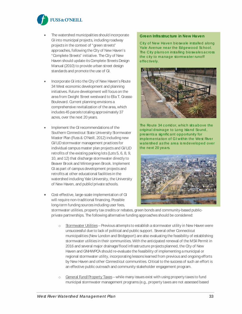
West River Watershed Management Plan 33
· The watershed municipalities should incorporateGI into municipal projects, including roadwayprojects in the context of “green streets”approaches, following the City of New Haven’s“Complete Streets” initiative. The City of NewHaven should update its Complete Streets DesignManual (2010) to provide urban street designstandards and promote the use of GI.
· Incorporate GI into the City of New Haven’s Route34 West economic development and planninginitiatives. Future development will focus on thearea from Dwight Street westward to Ella T. GrassoBoulevard. Current planning envisions acomprehensive revitalization of the area, whichincludes 45 parcels totaling approximately 37acres, over the next 20 years.
· Implement the GI recommendations of theSouthern Connecticut State University StormwaterMaster Plan (Fuss & O’Neill, 2012) including newGI/LID stormwater management practices forindividual campus master plan projects and GI/LIDretrofits of the existing parking lots (Lots 5, 6, 8, 9,10, and 12) that discharge stormwater directly toBeaver Brook and Wintergreen Brook. ImplementGI as part of campus development projects andretrofits at other educational facilities in thewatershed including Yale University, the Universityof New Haven, and public/private schools.
· Cost-effective, large-scale implementation of GIwill require non-traditional financing. Possiblelong-term funding sources including user fees,stormwater utilities, property tax credits or rebates, green bonds and community-based public-private partnerships. The following alternative funding approaches should be considered:
o Stormwater Utilities – Previous attempts to establish a stormwater utility in New Haven wereunsuccessful due to lack of political and public support. Several other Connecticutmunicipalities (New London and Bridgeport) are also evaluating the feasibility of establishingstormwater utilities in their communities. With the anticipated renewal of the MS4 Permit in2016 and several major drainage/flood infrastructure projects planned, the City of NewHaven and GNHWPCA should re-evaluate the feasibility of implementing a municipal orregional stormwater utility, incorporating lessons learned from previous and ongoing effortsby New Haven and other Connecticut communities. Critical to the success of such an effort isan effective public outreach and community stakeholder engagement program.
o General Fund/Property Taxes – while many issues exist with using property taxes to fundmunicipal stormwater management programs (e.g., property taxes are not assessed based
Green Infrastructure in New HavenCity of New Haven bioswale installed alongYale Avenue near the Edgewood School.The City plans on installing bioswales acrossthe city to manage stormwater runoffeffectively.
The Route 34 corridor, which sits above theoriginal drainage to Long Island Sound,presents a significant opportunity forimplementation of GI within the West Riverwatershed as the area is redeveloped overthe next 20 years.
West River Watershed Management Plan 34
on runoff generation, some significant runoff generators are tax-exempt, many competingpriorities for general funds), tax credits or incentive rate structures could be explored thatwould incentivize the use of green infrastructure by property owners.
o Clean Water Fund – grant and loan funding from the Connecticut Clean Water Fund shouldcontinue to be focused on implementing green infrastructure projects in the combined sewerareas of the West River watershed.
o Green Bonds – Green Bonds are a growing mechanism for funding green projects, includinggreen infrastructure and flood resilience projects. Green bonds are debt instruments issuedto finance environmental projects focused on climate change initiatives. The identificationand labeling of a green bond is typically based on a set of voluntary standards drafted by aconsortium of investment banks that outlines the process for issuers to designate specificgreen projects. The guidelines specify that a bond issue qualifies as green if the issuer usesthe proceeds solely for capital expenditures associated with green or climate-relatedenvironmental benefits in accordance with certain standards.
o Public Private Partnerships – A Community-Based Public Private Partnership (CBP3) is beingimplemented by Prince George’s County, Maryland with the support of EPA Region 3(http://www.epa.gov/reg3wapd/greeninfrastructure/GI_CB_P3_Guide_%20EPA_R3_FINAL_042115_508.pdf). A P3 is an arrangement between government and the private sector inwhich the private sector assumes a large share of the risk in terms of financing, constructing,and maintaining the infrastructure. Government repays the private sector over the long termif the infrastructure is built and maintained according to specifications. Prince George’sCounty is implementing a P3 program to retrofit 2,000 acres of impervious surfaces in thepublic right of way. Private funds will finance 30% to 40% of the program costs upfront,enabling project construction to begin sooner and proceed more quickly.
3.2.4 Residential Low Impact Development
Residential land use accounts for approximately 36% of the land area in the West River watershed. Residentialareas are a significant source of runoff and nonpoint source pollutant loads to the West River. The actions ofindividual homeowners can help to reduce runoff and pollutant loads to the combined and separate stormsewer systems in residential areas. The previous section describes larger-scale green infrastructurerecommendations primarily targeted at municipalities, institutions, and private development. Low ImpactDevelopment (LID) management practices can also be implemented by homeowners on individual residentiallots.
Residences in parts of the watershed generate significant quantities of rooftop runoff, which can also be asource of bacterial loads from birds and squirrels especially in areas with overhead tree canopy. Opportunitiesexist to disconnect residential rooftop runoff from the combined or storm drainage systems and reuse orredirect it to pervious areas through the use of rain barrels, rain gardens, and drywells.

West River Watershed Management Plan 35
Downspout disconnection can be a cost-effective option, incertain residential settings4, for reducing the volume andcost of stormwater that requires public management. Theuse of pervious materials for patios, walkways anddriveways, as well as pavement removal and planting newyard trees, can also reduce impervious surfaces onresidential lots and the contribution of runoff and pollutantloads to waterbodies.
Residential LID retrofits on individual lots target small areas,requiring the participation of many homeowners to make ameasurable difference across a watershed. A coordinatedeffort is required for widespread participation in such aprogram, which typically includes a combination of targetededucation, technical assistance, and financial subsidies tohomeowners. Successful implementation ofresidential/small-scale LID practices therefore requireshomeowner education and incentive programs.
Recommendations for implementation of residential LIDpractices in the West River watershed are described belowand summarized in Table 3-6.
Recommended Actions· Encourage disconnection of rooftop runoff from
the storm drainage system by redirecting exteriorroof leaders to pervious lawn areas and throughthe use of dry wells, rain barrels or rain gardens.
· The watershed municipalities, together with theGNHWPCA, should consider developing residential LID incentive programs to encourageimplementation of LID practices by homeowners, which will help reduce the burden on municipalstormwater and wastewater infrastructure for managing runoff from residential lots. Incentives toencourage residential property owners to use LID include:
o Stormwater Fee Discounts or Credits – reduced fees or utility bills by installing LID practices;requires a stormwater utility or similar fee-based system
o Rebates and Installation Financing – funding, property tax credits (i.e., reduction in propertytaxes), or reimbursements to property owners who install green infrastructure
o Workshop and Give-Away Programs - rain barrel workshops for homeowners that provide afree rain barrel to each participating household, along with training on how to install andmaintain the rain barrel
o Certification and Recognition Programs – certification of residential properties as watershed-friendly by implementing LID practices
4 In densely developed urban areas with combined sewer systems, such as parts of the West River watershed inNew Haven, downspout disconnection (i.e., roof leader separation) can be extremely expensive and less cost-effective than other BMPs since disconnecting roof leaders from the combined sewer system often requirescostly interior plumbing modifications.
Disconnecting Roof DownspoutsDisconnecting roof downspouts is one of theeasiest things homeowners can do to helpreduce stormwater runoff. Disconnectingdownspouts will reroute the runoff into rainbarrels or permeable areas like lawns or raingarden instead of the sewer.http://reducerunoff.org/downspout.htm(Save the Sound).
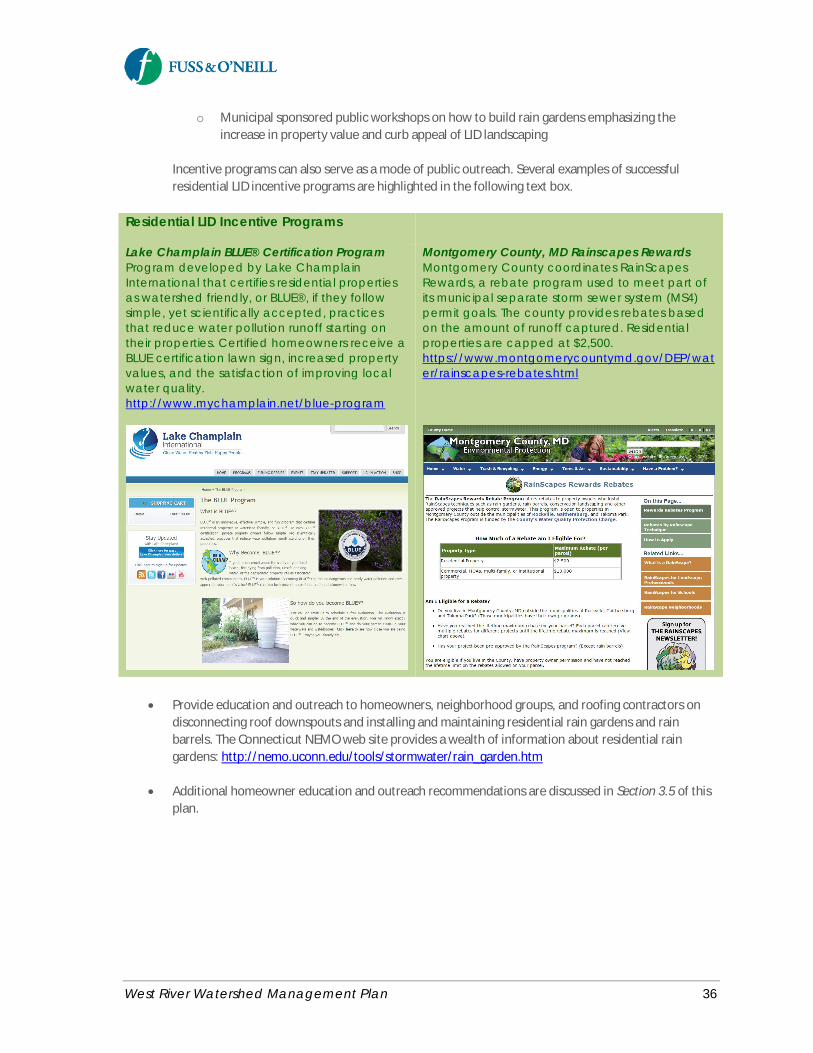
West River Watershed Management Plan 36
o Municipal sponsored public workshops on how to build rain gardens emphasizing theincrease in property value and curb appeal of LID landscaping
Incentive programs can also serve as a mode of public outreach. Several examples of successfulresidential LID incentive programs are highlighted in the following text box.
Residential LID Incentive Programs
Lake Champlain BLUE® Certification ProgramProgram developed by Lake ChamplainInternational that certifies residential propertiesas watershed friendly, or BLUE®, if they followsimple, yet scientifically accepted, practicesthat reduce water pollution runoff starting ontheir properties. Certified homeowners receive aBLUE certification lawn sign, increased propertyvalues, and the satisfaction of improving localwater quality.http://www.mychamplain.net/blue-program
Montgomery County, MD Rainscapes RewardsMontgomery County coordinates RainScapesRewards, a rebate program used to meet part ofits municipal separate storm sewer system (MS4)permit goals. The county provides rebates basedon the amount of runoff captured. Residentialproperties are capped at $2,500.https://www.montgomerycountymd.gov/DEP/water/rainscapes-rebates.html
· Provide education and outreach to homeowners, neighborhood groups, and roofing contractors ondisconnecting roof downspouts and installing and maintaining residential rain gardens and rainbarrels. The Connecticut NEMO web site provides a wealth of information about residential raingardens: http://nemo.uconn.edu/tools/stormwater/rain_garden.htm
· Additional homeowner education and outreach recommendations are discussed in Section 3.5 of thisplan.
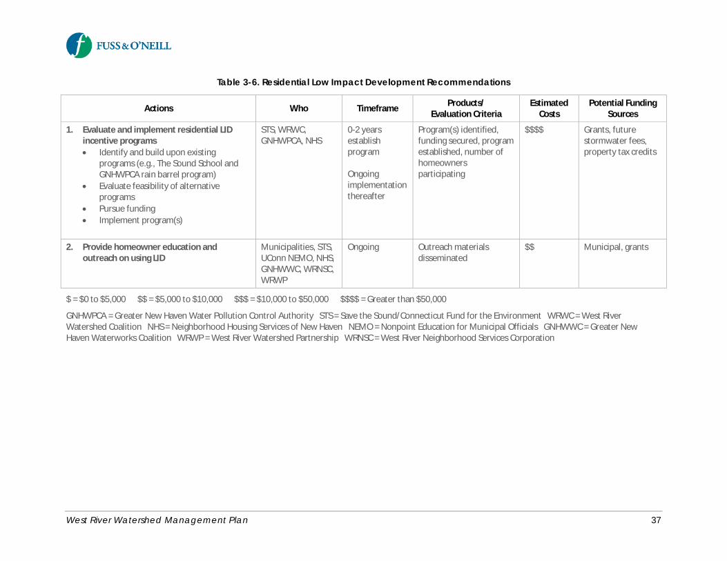
West River Watershed Management Plan 37
Table 3-6. Residential Low Impact Development Recommendations
Actions Who Timeframe Products/Evaluation Criteria
EstimatedCosts
Potential FundingSources
1. Evaluate and implement residential LIDincentive programs· Identify and build upon existing
programs (e.g., The Sound School andGNHWPCA rain barrel program)
· Evaluate feasibility of alternativeprograms
· Pursue funding· Implement program(s)
STS, WRWC,GNHWPCA, NHS
0-2 yearsestablishprogram
Ongoingimplementationthereafter
Program(s) identified,funding secured, programestablished, number ofhomeownersparticipating
$$$$ Grants, futurestormwater fees,property tax credits
2. Provide homeowner education andoutreach on using LID
Municipalities, STS,UConn NEMO, NHS,GNHWWC, WRNSC,WRWP
Ongoing Outreach materialsdisseminated
$$ Municipal, grants
$ = $0 to $5,000 $$ = $5,000 to $10,000 $$$ = $10,000 to $50,000 $$$$ = Greater than $50,000
GNHWPCA = Greater New Haven Water Pollution Control Authority STS = Save the Sound/Connecticut Fund for the Environment WRWC = West RiverWatershed Coalition NHS = Neighborhood Housing Services of New Haven NEMO = Nonpoint Education for Municipal Officials GNHWWC = Greater NewHaven Waterworks Coalition WRWP = West River Watershed Partnership WRNSC = West River Neighborhood Services Corporation
West River Watershed Management Plan 38
3.2.5 Municipal Stormwater ManagementPrograms
The stormwater collection and drainage systems within thewatershed consist of drainage infrastructure operated andmaintained by the watershed municipalities and theConnecticut Department of Transportation. Each of theseentities is a regulated small Municipal Separate Storm SewerSystem (MS4) under the CTDEEP General Permit for theDischarge of Stormwater from Small Municipal SeparateStorm Sewer Systems (MS4 Permit).
Through their MS4 Permit stormwater managementprograms and other planning initiatives, the watershedmunicipalities have developed and implemented a variety ofBest Management Practices to address stormwater qualityand quantity issues associated with municipal activities aswell as land development and redevelopment projects.
Construction sites that disturb one or more acres of land areregulated by the CTDEEP under the General Permit for theDischarge of Stormwater and Dewatering Wastewaters fromConstruction Activities. Municipalities also have jurisdictionover construction sites that disturb 0.5 or more acres of land.
Municipal stormwater management recommendations are summarized in Table 3-7.
Recommended ActionsThe watershed municipalities should continue to implement municipal stormwater management programs fortheir regulated MS4s, as required by the MS4 Permit. The six minimum control measures of the MS4 Permitinclude public education, public involvement, illicit discharge detection and elimination, construction siterunoff control, post-construction runoff control, and pollution prevention and good housekeeping. Specificrecommendations include:
· The South Central Regional Council of Governments (SCRCOG), together with the Capitol RegionCouncil of Governments (CRCOG), has expressed interest in forming a regional coalition of regulatedMS4s to facilitate sharing of resources to more cost-effectively comply with the new MS4 Permit.SCRCOG and CRCOG should take the lead in forming a regional coalition, borrowing from thesuccesses of similar regional stormwater coalitions in Massachusetts such as the CentralMassachusetts Regional Stormwater Coalition (http://centralmastormwater.org/Pages/index).
· The municipalities should consider requesting approval from CTDEEP for an alternative MS4 Permitmonitoring program to more effectively address the bacteria impairments in the West Riverwatershed. Monitoring may be performed by municipal staff, citizen volunteers, or contracted to anenvironmental consulting firm. The program must include sampling to address both objectives(source detection and progress quantification). Source detection monitoring may include suchactivities as visual inspection of storm sewer outfalls under dry weather conditions, event sampling ofindividual storm sewer outfalls, and monitoring of ambient (in-stream) conditions at closely spaced
Reissuance of CTDEEP MS4 Permit
CTDEEP is working with theConnecticut Conference ofMunicipalities, the Council of SmallTowns, and the Connecticut Fund forthe Environment to finalize the MS4Permit, which is expected to be re-issued in early 2016. The new permit isanticipated to contain more stringentrequirements relative to storm systemmapping, illicit discharge detectionand elimination, monitoring, andmore prescriptive requirements fordischarges to impaired waters, suchas the West River. The re-issuance ofthe MS4 Permit will require thewatershed municipalities to reviewand update their municipalstormwater management programsto meet the new permit requirements.
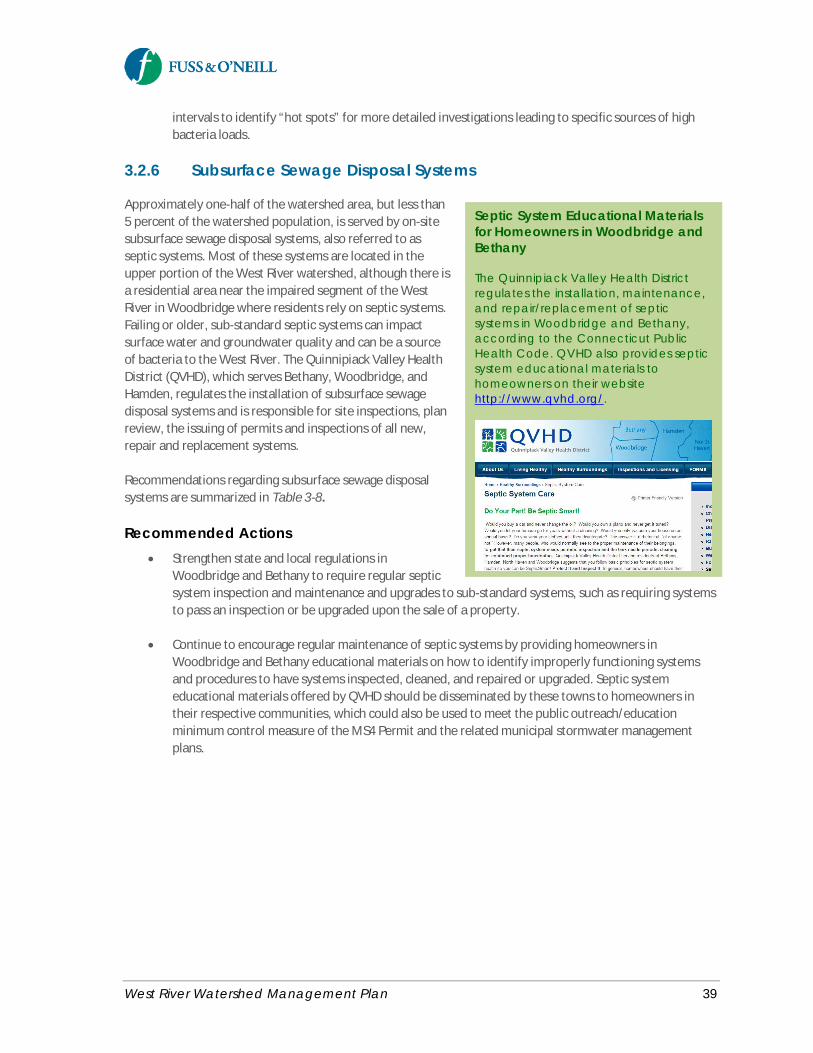
West River Watershed Management Plan 39
intervals to identify “hot spots” for more detailed investigations leading to specific sources of highbacteria loads.
3.2.6 Subsurface Sewage Disposal Systems
Approximately one-half of the watershed area, but less than5 percent of the watershed population, is served by on-sitesubsurface sewage disposal systems, also referred to asseptic systems. Most of these systems are located in theupper portion of the West River watershed, although there isa residential area near the impaired segment of the WestRiver in Woodbridge where residents rely on septic systems.Failing or older, sub-standard septic systems can impactsurface water and groundwater quality and can be a sourceof bacteria to the West River. The Quinnipiack Valley HealthDistrict (QVHD), which serves Bethany, Woodbridge, andHamden, regulates the installation of subsurface sewagedisposal systems and is responsible for site inspections, planreview, the issuing of permits and inspections of all new,repair and replacement systems.
Recommendations regarding subsurface sewage disposalsystems are summarized in Table 3-8.
Recommended Actions· Strengthen state and local regulations in
Woodbridge and Bethany to require regular septicsystem inspection and maintenance and upgrades to sub-standard systems, such as requiring systemsto pass an inspection or be upgraded upon the sale of a property.
· Continue to encourage regular maintenance of septic systems by providing homeowners inWoodbridge and Bethany educational materials on how to identify improperly functioning systemsand procedures to have systems inspected, cleaned, and repaired or upgraded. Septic systemeducational materials offered by QVHD should be disseminated by these towns to homeowners intheir respective communities, which could also be used to meet the public outreach/educationminimum control measure of the MS4 Permit and the related municipal stormwater managementplans.
Septic System Educational Materialsfor Homeowners in Woodbridge andBethany
The Quinnipiack Valley Health Districtregulates the installation, maintenance,and repair/replacement of septicsystems in Woodbridge and Bethany,according to the Connecticut PublicHealth Code. QVHD also provides septicsystem educational materials tohomeowners on their websitehttp://www.qvhd.org/.
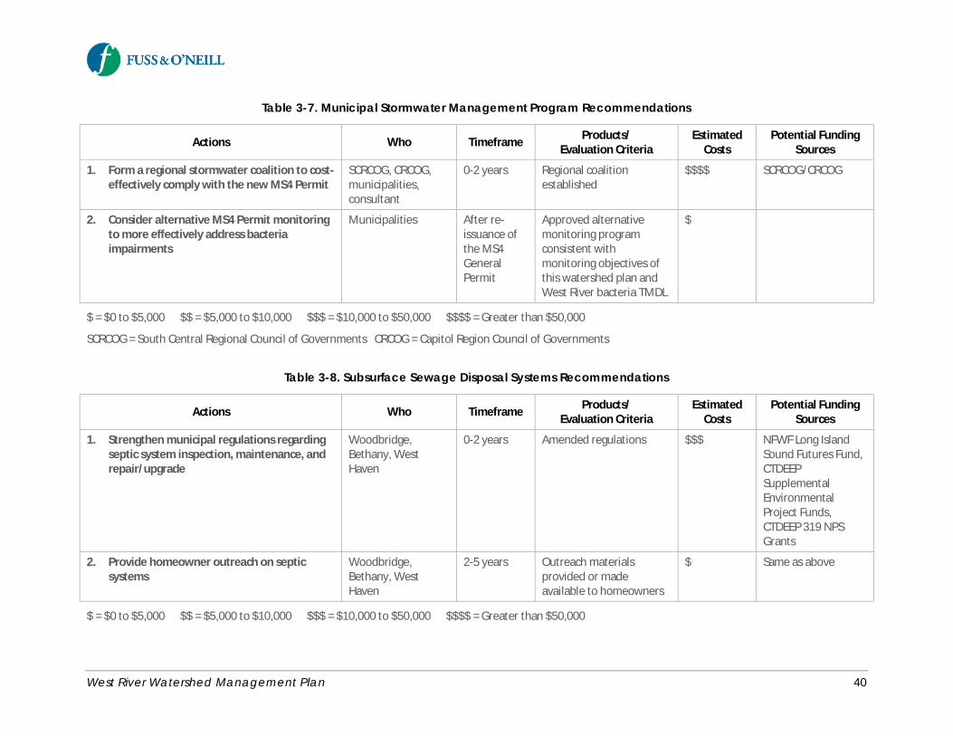
West River Watershed Management Plan 40
Table 3-7. Municipal Stormwater Management Program Recommendations
Actions Who Timeframe Products/Evaluation Criteria
EstimatedCosts
Potential FundingSources
1. Form a regional stormwater coalition to cost-effectively comply with the new MS4 Permit
SCRCOG, CRCOG,municipalities,consultant
0-2 years Regional coalitionestablished
$$$$ SCRCOG/CRCOG
2. Consider alternative MS4 Permit monitoringto more effectively address bacteriaimpairments
Municipalities After re-issuance ofthe MS4GeneralPermit
Approved alternativemonitoring programconsistent withmonitoring objectives ofthis watershed plan andWest River bacteria TMDL
$
$ = $0 to $5,000 $$ = $5,000 to $10,000 $$$ = $10,000 to $50,000 $$$$ = Greater than $50,000
SCRCOG = South Central Regional Council of Governments CRCOG = Capitol Region Council of Governments
Table 3-8. Subsurface Sewage Disposal Systems Recommendations
Actions Who Timeframe Products/Evaluation Criteria
EstimatedCosts
Potential FundingSources
1. Strengthen municipal regulations regardingseptic system inspection, maintenance, andrepair/upgrade
Woodbridge,Bethany, WestHaven
0-2 years Amended regulations $$$ NFWF Long IslandSound Futures Fund,CTDEEPSupplementalEnvironmentalProject Funds,CTDEEP 319 NPSGrants
2. Provide homeowner outreach on septicsystems
Woodbridge,Bethany, WestHaven
2-5 years Outreach materialsprovided or madeavailable to homeowners
$ Same as above
$ = $0 to $5,000 $$ = $5,000 to $10,000 $$$ = $10,000 to $50,000 $$$$ = Greater than $50,000
West River Watershed Management Plan 41
3.2.7 Illicit Connections and Discharges
Illicit discharges are non-stormwater flows that discharge into the stormwater drainage system or directly intosurface waters. Wastewater connections to the storm drain system, sanitary sewer overflows, and illegaldumping are among the types of illicit discharges that may exist in sewered residential and commercial areaswithin the watershed. Identifying and eliminating these discharges is an important means of pollution sourcecontrol for the watershed. Dry weather sources of bacteria such as illicit connections are the most likely to beidentified and effectively managed (and to include human sources). Controlling dry weather sources of bacteriais typically more cost-effective than trying to address elevated bacteria in wet weather conditions.
All of the watershed municipalities are subject to the requirements of the CTDEEP General Permit for theDischarge of Stormwater from Small Municipal Separate Storm Sewer Systems (MS4 Permit). The MS4 Permitregulates the quality of discharges from municipal storm drainage systems. The permit requires municipalitiesto implement an ordinance or other regulatory mechanism to effectively prohibit non-stormwater dischargesinto the municipal storm drainage system, as well as sanctions to ensure compliance. This includes developingand implementing an Illicit Discharge Detection and Elimination (IDDE) program to systematically find andeliminate sources of non-stormwater discharges to its municipal separate storm sewer system and implementprocedures to prevent such discharges.
Recommendations relative to eliminating illicit connections and discharges to the West River and its tributariesare summarized in Table 3-9.
Recommended Actions· The watershed municipalities should implement IDDE programs as required by the existing and future
re-issued MS4 Permit, including an ordinance or other regulatory mechanism to effectively prohibitnon-stormwater discharges into the regulated municipal separate storm sewer system and an IDDEprogram to detect and eliminate existing and future non-stormwater discharges, including illegaldumping.
o Educate municipal staff and the public about illicit discharges and the importance ofeliminating or avoiding such discharges.
o Implement priority stream cleanups identified by streamwalks and track down surveys.o Conduct follow-up illicit discharge investigations at priority outfalls identified during
stormwater outfall monitoring, streamwalks, and track down surveys.
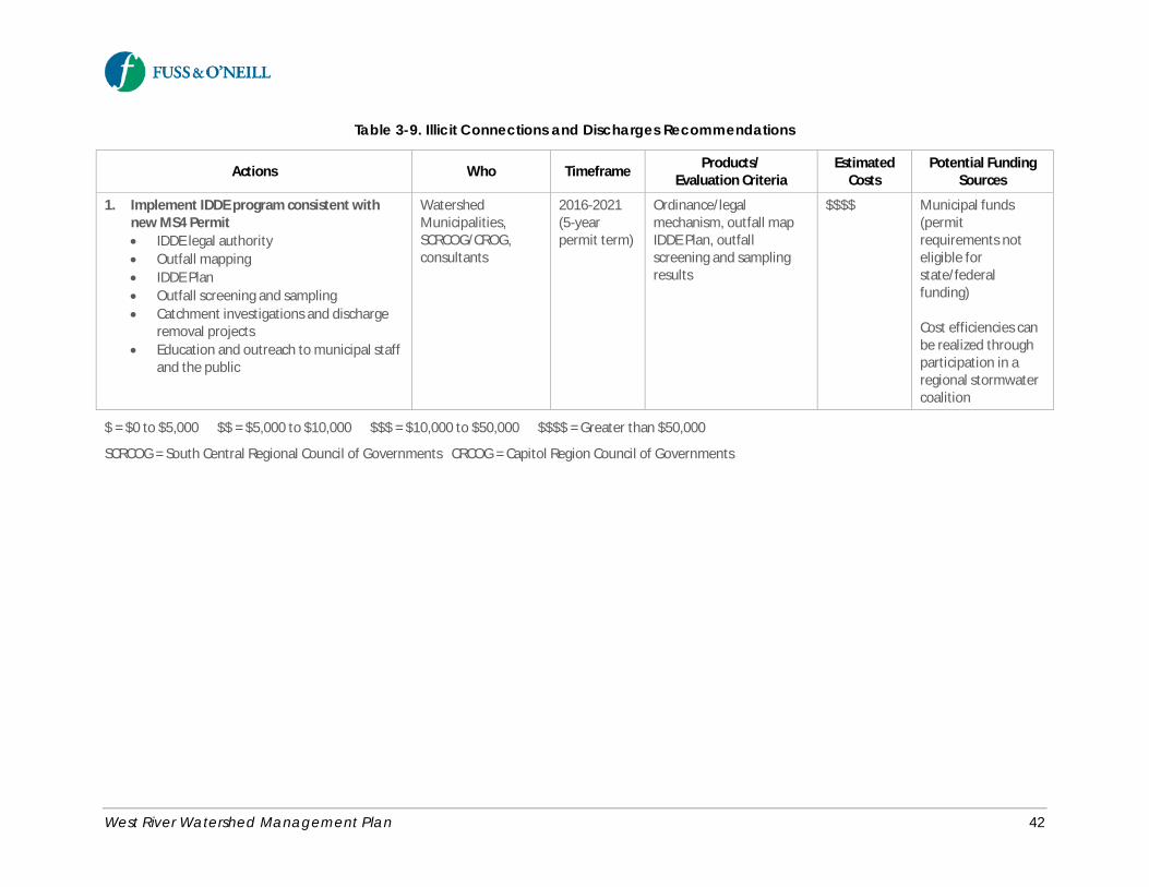
West River Watershed Management Plan 42
Table 3-9. Illicit Connections and Discharges Recommendations
Actions Who Timeframe Products/Evaluation Criteria
EstimatedCosts
Potential FundingSources
1. Implement IDDE program consistent withnew MS4 Permit· IDDE legal authority· Outfall mapping· IDDE Plan· Outfall screening and sampling· Catchment investigations and discharge
removal projects· Education and outreach to municipal staff
and the public
WatershedMunicipalities,SCRCOG/CROG,consultants
2016-2021(5-yearpermit term)
Ordinance/legalmechanism, outfall mapIDDE Plan, outfallscreening and samplingresults
$$$$ Municipal funds(permitrequirements noteligible forstate/federalfunding)
Cost efficiencies canbe realized throughparticipation in aregional stormwatercoalition
$ = $0 to $5,000 $$ = $5,000 to $10,000 $$$ = $10,000 to $50,000 $$$$ = Greater than $50,000
SCRCOG = South Central Regional Council of Governments CRCOG = Capitol Region Council of Governments

West River Watershed Management Plan 43
3.2.8 Commercial and Industrial Land Use
Commercial and industrial land uses have the potential for higher potential pollutant loads due to the pollutantsources associated with commercial and industrial activities and the significant runoff generated from thesehighly impervious sites. Most of the commercial development in the watershed is located along the majortransportation corridors including Route 15 and 63, Route 10 (Whalley Avenue), and Route 34 in the middleand lower watershed, and along Route 63 and 69 near the headwaters of the West River. Industrial land use isprimarily concentrated along the lower West River and tidal marsh south of Route 1, as well as isolatedindustrial properties such as the industrial park southeast of Konolds Pond.
Commercial and Industrial Land Uses in the Lower West RiverThe commercial and industrial areas along the lower West River south of Route 1 (highlighted in yellowbelow) are a source of stormwater runoff and associated pollutant loads to the impaired section of the river.
The commercial and industrial sites on the west side of Ella T. Grasso Boulevard in New Haven have largeamounts of impervious cover and discharge stormwater directly to the West River, with little or no naturalvegetation along the river. These public and privately-owned sites should be the focus of greeninfrastructure (GI) retrofits, or large-scale GI implementation during future redevelopment, and stream bufferrestoration. GI recommendations for the site of the New Haven Adult Education Center and Helene GrantSchool are provided in Appendix C.
The industrial sites on the west side of the river in West Haven, as well as other industrial facilities in thewatershed, should implement good housekeeping and source control best management practices toreduce exposure of materials and activities to stormwater runoff.

West River Watershed Management Plan 44
Recommendations related to reducing the impacts from commercial and industrial land uses are summarizedin Table 3-10.
Recommended Actions· Conduct outreach to commercial and industrial property owners in the watershed explaining how
their activities contribute to the water quality impairments of the West River.
· Consider establishing or strengthening municipal ordinances requiring covered trash enclosures andfrequent cleaning to reduce the bacteria load associated with dumpsters, consistent with the goodhousekeeping requirements in the CTDEEP industrial and commercial stormwater permit programs,which apply to certain categories of industrial facilities and to larger commercial sites such asshopping centers (e.g., Whalley Commons). Leaking dumpsters can be a major source of fecalindicator bacteria during wet weather. Include dumpster and trash management issues in commercialand industrial outreach.
· Strengthen CTDEEP inspection and enforcement of commercial and industrial facilities in thewatershed that are regulated under the CTDEEP industrial and commercial stormwater permitprograms, particularly those facilities that are located adjacent to that discharge directly to the WestRiver or its tributaries.
· Review the commercial and industrial facilities in the watershed to identify sites that are subject tothe CTDEEP industrial and commercial stormwater permit programs, but that are not currentlyregistered.
· Ensure that reissued NPDES industrial water discharge permits in the watershed contain provisions forTMDL implementation, LID, runoff volume reduction, and water quality protection.
· Promote green infrastructure and stream buffer restoration during redevelopment of largecommercial and industrial sites such as the properties along the east side of the lower West Riversouth of Route 1 and west of Ella T. Grasso Boulevard.
· Cleanup and promote sustainable re-use of contaminated sites including the use of greeninfrastructure.
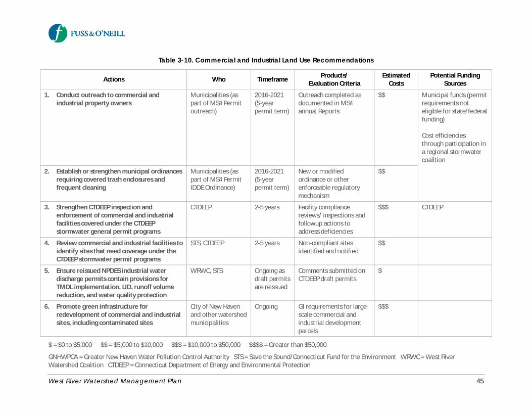
West River Watershed Management Plan 45
Table 3-10. Commercial and Industrial Land Use Recommendations
Actions Who Timeframe Products/Evaluation Criteria
EstimatedCosts
Potential FundingSources
1. Conduct outreach to commercial andindustrial property owners
Municipalities (aspart of MS4 Permitoutreach)
2016-2021(5-yearpermit term)
Outreach completed asdocumented in MS4annual Reports
$$ Municipal funds (permitrequirements noteligible for state/federalfunding)
Cost efficienciesthrough participation ina regional stormwatercoalition
2. Establish or strengthen municipal ordinancesrequiring covered trash enclosures andfrequent cleaning
Municipalities (aspart of MS4 PermitIDDE Ordinance)
2016-2021(5-yearpermit term)
New or modifiedordinance or otherenforceable regulatorymechanism
$$
3. Strengthen CTDEEP inspection andenforcement of commercial and industrialfacilities covered under the CTDEEPstormwater general permit programs
CTDEEP 2-5 years Facility compliancereviews/ inspections andfollowup actions toaddress deficiencies
$$$ CTDEEP
4. Review commercial and industrial facilities toidentify sites that need coverage under theCTDEEP stormwater permit programs
STS, CTDEEP 2-5 years Non-compliant sitesidentified and notified
$$
5. Ensure reissued NPDES industrial waterdischarge permits contain provisions forTMDL implementation, LID, runoff volumereduction, and water quality protection
WRWC, STS Ongoing asdraft permitsare reissued
Comments submitted onCTDEEP draft permits
$
6. Promote green infrastructure forredevelopment of commercial and industrialsites, including contaminated sites
City of New Havenand other watershedmunicipalities
Ongoing GI requirements for large-scale commercial andindustrial developmentparcels
$$$
$ = $0 to $5,000 $$ = $5,000 to $10,000 $$$ = $10,000 to $50,000 $$$$ = Greater than $50,000
GNHWPCA = Greater New Haven Water Pollution Control Authority STS = Save the Sound/Connecticut Fund for the Environment WRWC = West RiverWatershed Coalition CTDEEP = Connecticut Department of Energy and Environmental Protection
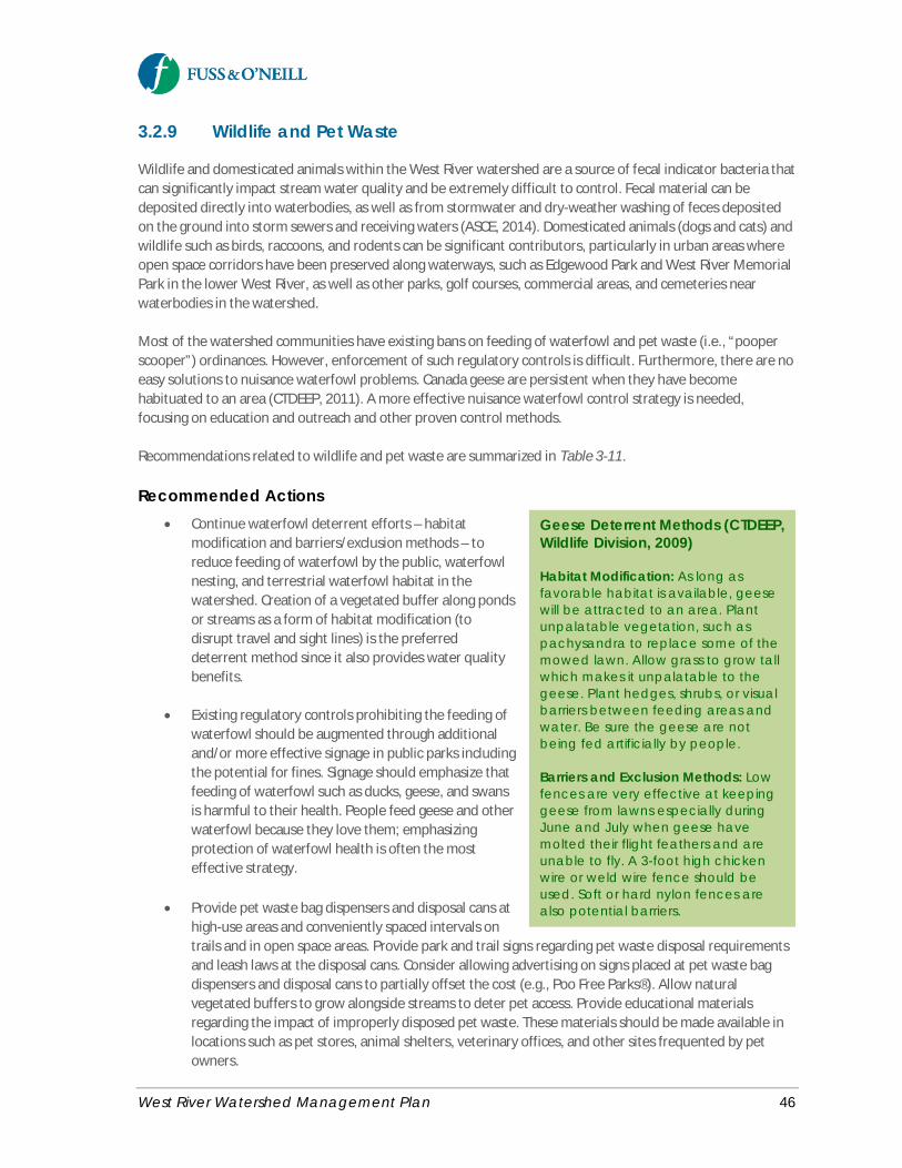
West River Watershed Management Plan 46
3.2.9 Wildlife and Pet Waste
Wildlife and domesticated animals within the West River watershed are a source of fecal indicator bacteria thatcan significantly impact stream water quality and be extremely difficult to control. Fecal material can bedeposited directly into waterbodies, as well as from stormwater and dry-weather washing of feces depositedon the ground into storm sewers and receiving waters (ASCE, 2014). Domesticated animals (dogs and cats) andwildlife such as birds, raccoons, and rodents can be significant contributors, particularly in urban areas whereopen space corridors have been preserved along waterways, such as Edgewood Park and West River MemorialPark in the lower West River, as well as other parks, golf courses, commercial areas, and cemeteries nearwaterbodies in the watershed.
Most of the watershed communities have existing bans on feeding of waterfowl and pet waste (i.e., “pooperscooper”) ordinances. However, enforcement of such regulatory controls is difficult. Furthermore, there are noeasy solutions to nuisance waterfowl problems. Canada geese are persistent when they have becomehabituated to an area (CTDEEP, 2011). A more effective nuisance waterfowl control strategy is needed,focusing on education and outreach and other proven control methods.
Recommendations related to wildlife and pet waste are summarized in Table 3-11.
Recommended Actions· Continue waterfowl deterrent efforts – habitat
modification and barriers/exclusion methods – toreduce feeding of waterfowl by the public, waterfowlnesting, and terrestrial waterfowl habitat in thewatershed. Creation of a vegetated buffer along pondsor streams as a form of habitat modification (todisrupt travel and sight lines) is the preferreddeterrent method since it also provides water qualitybenefits.
· Existing regulatory controls prohibiting the feeding ofwaterfowl should be augmented through additionaland/or more effective signage in public parks includingthe potential for fines. Signage should emphasize thatfeeding of waterfowl such as ducks, geese, and swansis harmful to their health. People feed geese and otherwaterfowl because they love them; emphasizingprotection of waterfowl health is often the mosteffective strategy.
· Provide pet waste bag dispensers and disposal cans athigh-use areas and conveniently spaced intervals ontrails and in open space areas. Provide park and trail signs regarding pet waste disposal requirementsand leash laws at the disposal cans. Consider allowing advertising on signs placed at pet waste bagdispensers and disposal cans to partially offset the cost (e.g., Poo Free Parks®). Allow naturalvegetated buffers to grow alongside streams to deter pet access. Provide educational materialsregarding the impact of improperly disposed pet waste. These materials should be made available inlocations such as pet stores, animal shelters, veterinary offices, and other sites frequented by petowners.
Geese Deterrent Methods (CTDEEP,Wildlife Division, 2009)
Habitat Modification: As long asfavorable habitat is available, geesewill be attracted to an area. Plantunpalatable vegetation, such aspachysandra to replace some of themowed lawn. Allow grass to grow tallwhich makes it unpalatable to thegeese. Plant hedges, shrubs, or visualbarriers between feeding areas andwater. Be sure the geese are notbeing fed artificially by people.
Barriers and Exclusion Methods: Lowfences are very effective at keepinggeese from lawns especially duringJune and July when geese havemolted their flight feathers and areunable to fly. A 3-foot high chickenwire or weld wire fence should beused. Soft or hard nylon fences arealso potential barriers.
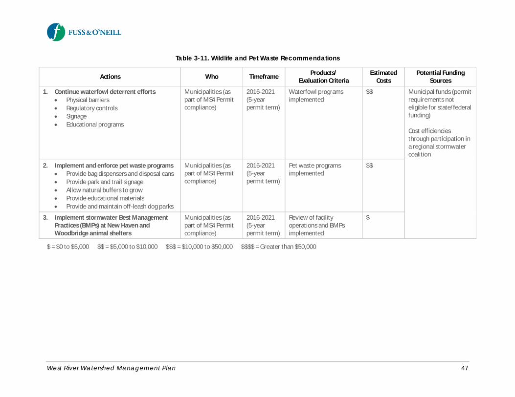
West River Watershed Management Plan 47
Table 3-11. Wildlife and Pet Waste Recommendations
Actions Who Timeframe Products/Evaluation Criteria
EstimatedCosts
Potential FundingSources
1. Continue waterfowl deterrent efforts· Physical barriers· Regulatory controls· Signage· Educational programs
Municipalities (aspart of MS4 Permitcompliance)
2016-2021(5-yearpermit term)
Waterfowl programsimplemented
$$ Municipal funds (permitrequirements noteligible for state/federalfunding)
Cost efficienciesthrough participation ina regional stormwatercoalition
2. Implement and enforce pet waste programs· Provide bag dispensers and disposal cans· Provide park and trail signage· Allow natural buffers to grow· Provide educational materials· Provide and maintain off-leash dog parks
Municipalities (aspart of MS4 Permitcompliance)
2016-2021(5-yearpermit term)
Pet waste programsimplemented
$$
3. Implement stormwater Best ManagementPractices (BMPs) at New Haven andWoodbridge animal shelters
Municipalities (aspart of MS4 Permitcompliance)
2016-2021(5-yearpermit term)
Review of facilityoperations and BMPsimplemented
$
$ = $0 to $5,000 $$ = $5,000 to $10,000 $$$ = $10,000 to $50,000 $$$$ = Greater than $50,000
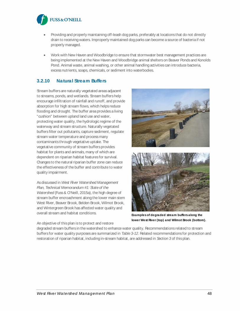
West River Watershed Management Plan 48
· Providing and properly maintaining off-leash dog parks, preferably at locations that do not directlydrain to receiving waters. Improperly maintained dog parks can become a source of bacteria if notproperly managed.
· Work with New Haven and Woodbridge to ensure that stormwater best management practices arebeing implemented at the New Haven and Woodbridge animal shelters on Beaver Ponds and KonoldsPond. Animal waste, animal washing, or other animal handling activities can introduce bacteria,excess nutrients, soaps, chemicals, or sediment into waterbodies.
3.2.10 Natural Stream Buffers
Stream buffers are naturally vegetated areas adjacentto streams, ponds, and wetlands. Stream buffers helpencourage infiltration of rainfall and runoff, and provideabsorption for high stream flows, which helps reduceflooding and drought. The buffer area provides a living“cushion” between upland land use and water,protecting water quality, the hydrologic regime of thewaterway and stream structure. Naturally vegetatedbuffers filter out pollutants, capture sediment, regulatestream water temperature and process manycontaminants through vegetative uptake. Thevegetative community of stream buffers provideshabitat for plants and animals, many of which aredependent on riparian habitat features for survival.Changes to the natural riparian buffer zone can reducethe effectiveness of the buffer and contribute to waterquality impairment.
As discussed in West River Watershed ManagementPlan, Technical Memorandum #1: State of theWatershed (Fuss & O’Neill, 2015a), the high degree ofstream buffer encroachment along the lower main stemWest River, Beaver Brook, Belden Brook, Wilmot Brook,and Wintergreen Brook has affected water quality andoverall stream and habitat conditions.
An objective of this plan is to protect and restoredegraded stream buffers in the watershed to enhance water quality. Recommendations related to streambuffers for water quality purposes are summarized in Table 3-12. Related recommendations for protection andrestoration of riparian habitat, including in-stream habitat, are addressed in Section 3 of this plan.
Examples of degraded stream buffers along thelower West River (top) and Wilmot Brook (bottom).
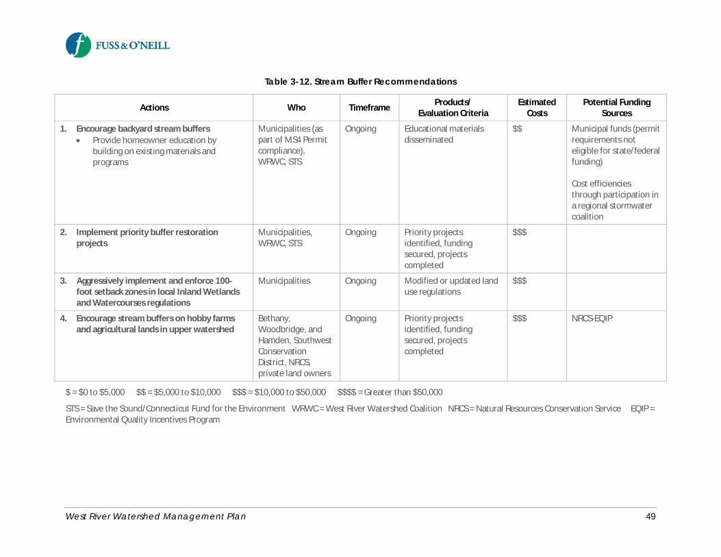
West River Watershed Management Plan 49
Table 3-12. Stream Buffer Recommendations
Actions Who Timeframe Products/Evaluation Criteria
EstimatedCosts
Potential FundingSources
1. Encourage backyard stream buffers· Provide homeowner education by
building on existing materials andprograms
Municipalities (aspart of MS4 Permitcompliance),WRWC, STS
Ongoing Educational materialsdisseminated
$$ Municipal funds (permitrequirements noteligible for state/federalfunding)
Cost efficienciesthrough participation ina regional stormwatercoalition
2. Implement priority buffer restorationprojects
Municipalities,WRWC, STS
Ongoing Priority projectsidentified, fundingsecured, projectscompleted
$$$
3. Aggressively implement and enforce 100-foot setback zones in local Inland Wetlandsand Watercourses regulations
Municipalities Ongoing Modified or updated landuse regulations
$$$
4. Encourage stream buffers on hobby farmsand agricultural lands in upper watershed
Bethany,Woodbridge, andHamden, SouthwestConservationDistrict, NRCS,private land owners
Ongoing Priority projectsidentified, fundingsecured, projectscompleted
$$$ NRCS-EQIP
$ = $0 to $5,000 $$ = $5,000 to $10,000 $$$ = $10,000 to $50,000 $$$$ = Greater than $50,000
STS = Save the Sound/Connecticut Fund for the Environment WRWC = West River Watershed Coalition NRCS = Natural Resources Conservation Service EQIP =Environmental Quality Incentives Program
West River Watershed Management Plan 50
Recommended Actions· Encourage the creation of backyard buffers in residential areas near stream corridors, including the
importance of maintaining healthy vegetated buffers to streams, ponds, and wetlands, and recognizethe efforts of the public.
o Educate homeowners about the value and importance of stream buffers by building onexisting stream buffer outreach and educational programming (e.g., public recognitionprograms for cooperating landowners, Streamside Landowners’ Guide to the QuinnipiacGreenway, Audubon’s backyard program, and programs from the EPA- Long Island SoundStudy and Connecticut Sea Grant).
· Implement priority buffer restoration projects identified during streamwalks and watershed fieldinventories.
o Focus efforts on publicly-owned, high-profile sites such as existing parks along the WestRiver, as well as smaller tributaries, ponds, and lakes. Technical Memorandum #2: LowImpact Development and Green Infrastructure Assessment (Fuss & O’Neill, 2015b) (AppendixC) identifies several potential stream buffer restoration candidates based on limited fieldinventories, including site-specific concepts for several of these potential opportunities.Future streamwalks and track down surveys will help to identify additional stream bufferrestoration candidates.
o Potential buffer restoration approaches for the watershed include installation of newbuffers, widening existing buffers, invasive species removal/management, and treeplanting/reforestation.
o Preserve and enhance stream buffers that provide public access to the West River and itstributaries.
o Engage volunteers in riparian buffer implementation projects.o Further evaluate the feasibility of buffer restoration at specific sites based on consideration
of site-specific factors including site access, available land area, land ownership, soilconditions, appropriate buffer width, and native plant species.
· Provide stream buffer protection through aggressive implementation and enforcement of 100-footsetback zones in local Inland Wetlands and Watercourses regulations. Consider modifying existingland use regulations to incorporate incentives for developers to restore or establish vegetative buffersas part of new development or redevelopment.
· Ensure there are sufficient stream buffers along agricultural lands in the upper portion of the WestRiver watershed (Bethany, Woodbridge, and Hamden), including farms along Wilmot (Farm) Brook,Belden Brook, and Sargent River. Priority should be given to farms where agricultural operations suchas fields and pastures are in close proximity to the streams, including hobby farms. Focusingagricultural BMPs to improve buffer areas around streams will reduce the volume and improve thequality of stormwater runoff from the farm before it enters the stream. Other related conservationpractices that should be considered for these farms include vegetated filter strips, stream habitatimprovement and protection, and streambank protection projects. The USDA Natural ResourcesConservation Service (NRCS) National Water Quality Initiative offers financial and technical assistanceto farmers and forest landowners interested in improving water quality and aquatic habitats inpriority watersheds with impaired streams.
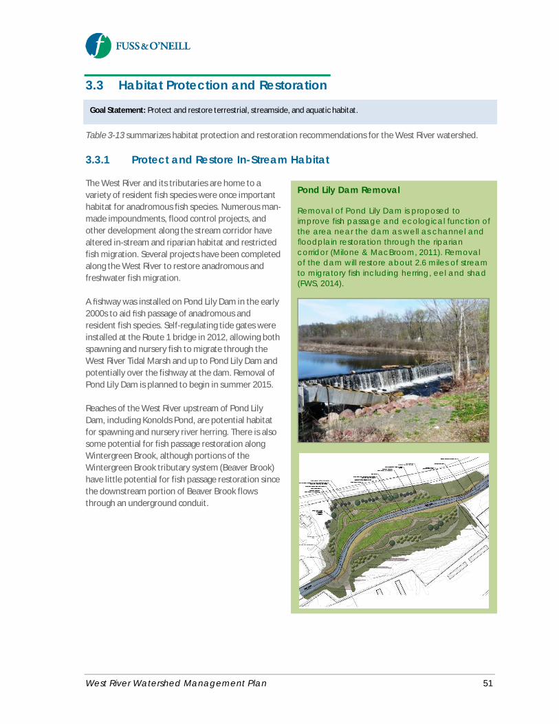
West River Watershed Management Plan 51
Goal Statement: Protect and restore terrestrial, streamside, and aquatic habitat.
3.3 Habitat Protection and Restoration
Table 3-13 summarizes habitat protection and restoration recommendations for the West River watershed.
3.3.1 Protect and Restore In-Stream Habitat
The West River and its tributaries are home to avariety of resident fish species were once importanthabitat for anadromous fish species. Numerous man-made impoundments, flood control projects, andother development along the stream corridor havealtered in-stream and riparian habitat and restrictedfish migration. Several projects have been completedalong the West River to restore anadromous andfreshwater fish migration.
A fishway was installed on Pond Lily Dam in the early2000s to aid fish passage of anadromous andresident fish species. Self-regulating tide gates wereinstalled at the Route 1 bridge in 2012, allowing bothspawning and nursery fish to migrate through theWest River Tidal Marsh and up to Pond Lily Dam andpotentially over the fishway at the dam. Removal ofPond Lily Dam is planned to begin in summer 2015.
Reaches of the West River upstream of Pond LilyDam, including Konolds Pond, are potential habitatfor spawning and nursery river herring. There is alsosome potential for fish passage restoration alongWintergreen Brook, although portions of theWintergreen Brook tributary system (Beaver Brook)have little potential for fish passage restoration sincethe downstream portion of Beaver Brook flowsthrough an underground conduit.
Pond Lily Dam Removal
Removal of Pond Lily Dam is proposed toimprove fish passage and ecological function ofthe area near the dam as well as channel andoodplain restoration through the ripariancorridor (Milone & MacBroom, 2011). Removalof the dam will restore about 2.6 miles of streamto migratory fish including herring, eel and shad(FWS, 2014).

West River Watershed Management Plan 52
Table 3-13. Habitat Protection and Restoration Recommendations
Actions Who Timeframe Products/Evaluation Criteria
EstimatedCosts
Potential FundingSources
In-Stream Habitat
1. Conduct stream crossing surveys WRWC, STS, TNC 2-5 years Completed surveys withprioritizedrecommendations
$$$ Grant funding – NFWF,Hurricane SandyDisaster Recovery
2. Revise local design standards for streamcrossings
Municipalities 2-5 years Revised standards $$
3. Remove Pond Lily Dam STS 0-2 years Construction completed $$$$ Hurricane SandyDisaster Recovery Funds
4. Add a fishway to Konolds Pond Dam CTDEEP, STS, WRWC 5-10 years Funding secured, designcompleted, fishwayinstalled
$$$$ Grant funding – NFWF
5. Implement priority stream restorationprojects
WRWC, STS,municipalities
5-10 years Completed projects $$$$ Grant funding – NFWF
Forested Areas and Tree Canopy
6. Establish a tree canopy goal in New Haven New Haven, URI 5-10+ years Numeric or qualitativetree canopy goal andimplementation criteria
$$$
7. Implement sustainable managementpractices in woodlands along utility corridors
United Illuminating,UConn
Ongoing Use of BMPs for treecutting along utility lines
$$$$
8. Amend site development regulations andzoning
Municipalities,consultants
5-10 years Amendments to local landuse regulations andpolicies
$$$
9. Implement tree canopy demonstrationprojects
Municipalities, URI 5-10 years Completed projects $$$
10. Protect forested land through landacquisition and conservation easements
Municipalities Ongoing Area of forest landacquired or preserved
$$$$
Invasive Plant Species
11. Implement priority invasive speciesmanagement projects identified during
WRWC, CFE,Municipalities, URI
Ongoing Completed projects $$$
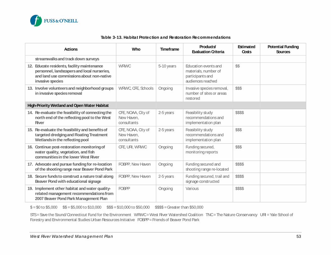
West River Watershed Management Plan 53
Table 3-13. Habitat Protection and Restoration Recommendations
Actions Who Timeframe Products/Evaluation Criteria
EstimatedCosts
Potential FundingSources
streamwalks and track down surveys
12. Educate residents, facility maintenancepersonnel, landscapers and local nurseries,and land use commissions about non-nativeinvasive species
WRWC 5-10 years Education events andmaterials, number ofparticipants andaudiences reached
$$
13. Involve volunteers and neighborhood groupsin invasive species removal
WRWC, CFE, Schools Ongoing Invasive species removal,number of sites or areasrestored
$$$
High-Priority Wetland and Open Water Habitat
14. Re-evaluate the feasibility of connecting thenorth end of the reflecting pool to the WestRiver
CFE, NOAA, City ofNew Haven,consultants
2-5 years Feasibility studyrecommendations andimplementation plan
$$$$
15. Re-evaluate the feasibility and benefits oftargeted dredging and Floating TreatmentWetlands in the reflecting pool
CFE, NOAA, City ofNew Haven,consultants
2-5 years Feasibility studyrecommendations andimplementation plan
$$$
16. Continue post-restoration monitoring ofwater quality, vegetation, and fishcommunities in the lower West River
CFE, URI, WRWC Ongoing Funding secured,monitoring reports
$$$
17. Advocate and pursue funding for re-locationof the shooting range near Beaver Pond Park
FOBPP, New Haven Ongoing Funding secured andshooting range re-located
$$$$
18. Secure funds to construct a nature trail alongBeaver Pond with educational signage
FOBPP, New Haven 2-5 years Funding secured, trail andsignage constructed
$$$$
19. Implement other habitat and water quality-related management recommendations from2007 Beaver Pond Park Management Plan
FOBPP Ongoing Various $$$$
$ = $0 to $5,000 $$ = $5,000 to $10,000 $$$ = $10,000 to $50,000 $$$$ = Greater than $50,000
STS = Save the Sound/Connecticut Fund for the Environment WRWC = West River Watershed Coalition TNC = The Nature Conservancy URI = Yale School ofForestry and Environmental Studies Urban Resources Initiative FOBPP = Friends of Beaver Pond Park
West River Watershed Management Plan 54
Other issues that affect in-stream habitat in the West River watershed include elevated stream temperaturesdue to a lack of stream shading and inputs of stormwater runoff, abnormally low flows during dry weather, andnumerous culverts on smaller streams that impede resident fish migration.
Recommended Actions· Conduct a stream crossing (culvert and bridge) survey of the West River watershed for anadromous
and resident fish species to identify and prioritize barriers to fish passage and opportunities forrestoring fish passage. The survey should focus on areas of the watershed that have not yet beenassessed, including the West River upstream of Konolds Pond and Wintergreen Brook, Wilmot Brook,and Belden Brook. The survey should follow standardized protocols recently developed by the NorthAtlantic Aquatic Connectivity Collaborative https://www.streamcontinuity.org/.
· Revise local storm drainage design standards such that new or modified stream crossings aredesigned following the Connecticut Stream Crossing Guidelines (CTDEEP, 2008).
· Complete the planned removal of Pond Lily Dam and associated ecological restoration project.
· Following the removal of Pond Lily Dam, CTDEEP should initiate a community-based effort to add afishway to Konolds Pond Dam to increase fish migration into Konolds Pond. CTDEEP has identifiedKonolds Pond as critical habitat for spawning and nursery river herring. The spillway is very low andgently sloped, and CTDEEP believes that some fish can enter Konolds Pond at certain flow levels.
· Implement priority stream restoration projects identified during streamwalks and track down surveys.Address areas of stream erosion and sedimentation using appropriate bioengineering and habitat-sensitive measures.
o Explore the feasibility of daylighting portions of the roughly ¼-mile culverted section ofBeaver Brook that flows beneath a residential and commercial area starting upstream ofBlake Street to approximately 50 yards upstream of the confluence with Wintergreen Brook.
3.3.2 Protect and Restore Forested Areasand Tree Canopy
Forest cover, including natural forest soils with irregular topography, provides numerous benefits at both thesite and watershed scales. In addition to providing habitat for terrestrial and aquatic wildlife, watershed forestcover also reduces stormwater runoff and flooding, improves regional air quality, reduces stream and channelerosion, improves soil and water quality, and reduces summer air and water temperatures (USDA ForestService, 2005).
Forested areas comprise approximately 50% of the West River watershed. Most of this forestland is located inthe northern portion of the watershed, with much lower levels of tree canopy in the lower watershed. Thefollowing recommendations (summarized in Table 3-13) will help protect existing forested areas and enhancethe tree canopy in the more urban areas of the watershed.
West River Watershed Management Plan 55
Recommended Actions· In 2009, the City of New Haven and Yale’s Urban Resources Initiative (URI) began a tree planting
program with a goal of planting 10,000 public trees in five years (aka “Tree Haven 10K Pledge”).Consistent with its Draft Comprehensive Plan Update (New Haven Vision 2025), the City shouldcontinue to partner with URI to establish a goal for enhancing tree canopy in New Haven, focusing onparcels with no or little existing tree canopy, large amounts of impervious surfaces (such as formercommercial and industrial sites), and proximity to the West River and its tributaries.
· Implement sustainable management practices in woodlands along utility corridors. Utility companiesstatewide, including The United Illuminating Company (UI), continue to implement tree and forestmanagement programs to reduce the risk of tree-related storm damage to power lines. UI shouldimplement Best Management Practices and strategies for storm-related utility line tree cutting. The“Stormwise” vegetation management initiative and research program led by UConn and the CTAgricultural Experiment Station, partnered with various stakeholders including UI and other utilitycompanies, is identifying management strategies to reduce the risk of tree-related power andtransportation disruptions during storms while sustaining trees and forested areas and protectingwetlands and water quality.
· Amend site development regulations and zoning to encourage tree retention and maintenance,restrict tree removal, and require landscaping and parking lot shading. Consider developing a treeordinance, especially for canopy protection along the river corridor.
· Demonstrate the importance of trees and vegetation as a critical component of green infrastructureand the related water quality benefits through local tree canopy demonstration projects.
· Protect existing forested land through land acquisition and conservation easements.
3.3.3 Manage Invasive Plant Species
Native vegetation plays an important role in ecosystem biodiversity. Invasive plant species, which are mostlynon-native plant species that successfully out-compete native plants, are prevalent throughout the watershed.The most common invasive plant species observed in the watershed include multiflora rose, Japaneseknotweed, Norway maple, purple loosestrife, common reed, and Oriental or ornamental bittersweet. Anumber of organizations have been involved in invasive species control efforts at targeted locations in thewatershed such as Edgewood Park, Beaver Ponds Park, and the West River Tidal Marsh.
Recommended Actions· Focus invasive species management efforts on site-specific and targeted stream corridor
improvements identified during streamwalks and track down surveys. Focus on properties that areactively maintained with opportunity and interest for control since it is impractical to successfullycontrol or eradicate invasive plant species on unmaintained sites.
· Educate residents, facility maintenance personnel, landscapers and local nurseries, and land usecommissions about the negative effects of non-native invasive species, pathways of introduction, andalternatives to invasive ornamental plants.
· Involve volunteers and neighborhood groups in invasive species removal and stream corridorimprovements.
West River Watershed Management Plan 56
3.3.4 Protect and Restore High-PriorityWetland and Open Water Habitat
The West River Tidal Marsh has been the focus of extensive study and habitat restoration efforts. In 1994, theWest River Memorial Park was listed by the CTDEEP as a potential salt marsh restoration site. A preliminaryengineering study was conducted for the restoration of West River Memorial Park. Potential restorationactivities that were investigated include expanding an existing pond area in the southeastern section of thepark; dredging an existing sediment bar in the reflecting pool; connecting the West River with the head of thereflecting pool; constructing a bridge at the connection between the West River and Horseshoe Lagoon;expanding the southern confluence of the West River and reflecting pool; opening one or two tide gate flaps;and excavating the existing marsh along Ella Grasso Boulevard to encourage tidal flooding (Milone &MacBroom, 2002b).
The tidal marsh and channel restoration was completed in 2012, which involved replacing three of the oldtimber tide gates with self-regulating gates to enable better exchange of tidal waters with the lower portion ofWest River and provide flushing of stagnant portions of the dredged channel. The alteration was found toimprove water quality in the river and restore portions of the tidal marsh. As part of the restoration project,invasive species were removed from Edgewood Park and public access was improved with a raised walkway(Milone & MacBroom, 2012).
Although the West River tide gate project has had an immediate, positive impact on the West River andsurrounding marsh, the reflecting pool does not receive as much tidal flushing as the main stem of the river,and the duck pond and main stem of the West River above Chapel Street receive little saline influence.Dissolved oxygen levels in the lower West River continue to fluctuate above and below safe levels for fishpopulations due to impacts from combined sewer overflows and other pollutant sources (CFE, 2013).
There has also been significant interest by local groups, led by the Friends of Beaver Pond Park, in protectingand restoring Beaver Pond Park. Owned by the City of New Haven, Beaver Pond Park is approximately 107acres and contains athletic fields and an approximately 86-acre wetland and pond system that consists of twodistinct ponds with dense shoreline vegetation, a red maple swamp, the Sherman Forest, and two small cattailmarshes. Southern Connecticut State University abuts the ponds. The ponds receive stormwater from an urbanwatershed of approximately 1,200 acres (Bates et al., 2007). The Management Plan for Beaver Pond Park(Bates et al., 2007) developed recommendations for the park and ponds.
Lastly, Pond Lily and Konolds Pond are the focus of ongoing and planned fish passage restoration efforts toopen up additional reaches of the West River to fish migration and breeding habitat.
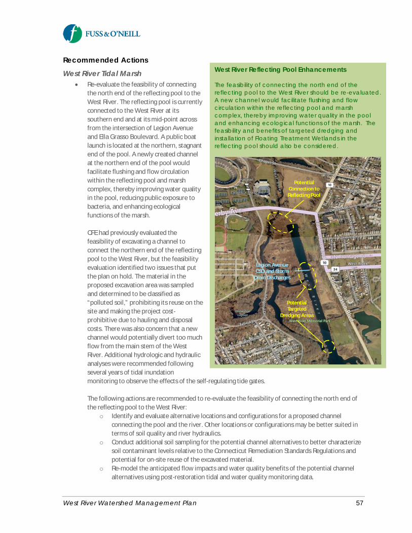
West River Watershed Management Plan 57
Recommended Actions
West River Tidal Marsh· Re-evaluate the feasibility of connecting
the north end of the reflecting pool to theWest River. The reflecting pool is currentlyconnected to the West River at itssouthern end and at its mid-point acrossfrom the intersection of Legion Avenueand Ella Grasso Boulevard. A public boatlaunch is located at the northern, stagnantend of the pool. A newly created channelat the northern end of the pool wouldfacilitate flushing and flow circulationwithin the reflecting pool and marshcomplex, thereby improving water qualityin the pool, reducing public exposure tobacteria, and enhancing ecologicalfunctions of the marsh.
CFE had previously evaluated thefeasibility of excavating a channel toconnect the northern end of the reflectingpool to the West River, but the feasibilityevaluation identified two issues that putthe plan on hold. The material in theproposed excavation area was sampledand determined to be classified as“polluted soil,” prohibiting its reuse on thesite and making the project cost-prohibitive due to hauling and disposalcosts. There was also concern that a newchannel would potentially divert too muchflow from the main stem of the WestRiver. Additional hydrologic and hydraulicanalyses were recommended followingseveral years of tidal inundationmonitoring to observe the effects of the self-regulating tide gates.
The following actions are recommended to re-evaluate the feasibility of connecting the north end ofthe reflecting pool to the West River:
o Identify and evaluate alternative locations and configurations for a proposed channelconnecting the pool and the river. Other locations or configurations may be better suited interms of soil quality and river hydraulics.
o Conduct additional soil sampling for the potential channel alternatives to better characterizesoil contaminant levels relative to the Connecticut Remediation Standards Regulations andpotential for on-site reuse of the excavated material.
o Re-model the anticipated flow impacts and water quality benefits of the potential channelalternatives using post-restoration tidal and water quality monitoring data.
West River Reflecting Pool Enhancements
The feasibility of connecting the north end of thereflecting pool to the West River should be re-evaluated.A new channel would facilitate flushing and flowcirculation within the reflecting pool and marshcomplex, thereby improving water quality in the pooland enhancing ecological functions of the marsh. Thefeasibility and benefits of targeted dredging andinstallation of Floating Treatment Wetlands in thereflecting pool should also be considered.
PotentialConnection toReflecting Pool
PotentialTargeted
Dredging Areas
Legion AvenueCSO and Storm
Drain Discharges
West River Watershed Management Plan 58
o Update project costs and pursue funding for the project.o Complete design, permitting, and construction.
· Re-evaluate the feasibility and benefits of targeted dredging in the reflecting pool. A previousengineering study by Milone & MacBroom (2002b) recommended dredging of a sand bar in thereflecting pool immediately downstream of the Legion Avenue CSO and storm drain dischargelocations, which is an obstacle to canoe passage and limits flushing of the reflecting pool. Sedimentsin the reflecting pool in the vicinity of the CSO discharge may also be a significant source of fecalindicator bacteria since sediments often function as a reservoir in which microorganisms can persist.Dredging of existing sand bars and bacteria-rich sediment near the Legion Avenue CSO and stormdrain discharges should be considered.
· Evaluate the feasibility of installing Floating Treatment Wetlands (FTWs) in the West River reflectingpool in the vicinity of the CSO and stormwater outfalls. FTWs could potentially be used to treatstormwater and CSO discharges. Also evaluate the feasibility of bioremediation of contaminatedsediments in the reflecting pool and Horseshoe Lagoon as an alternative to dredging.
· Continue post-restoration monitoring of water quality (salinity, dissolved oxygen, and tidal range),vegetation, and fish communities in the lower West River to evaluate the effectiveness of thecompleted and ongoing habitat restoration efforts within and upstream of the West River tidal marsh.CFE and Yale professor Gaboury Benoit, who has a permanent data logger stationed in the West River,should continue to seek funding for ongoing post-restoration monitoring.
Beaver Ponds· Continue to advocate and pursue funding for re-location of the existing active shooting range that
operates on the grounds of the Police Academy in Beaver Pond Park, just east of the South Pond andnorth of Sherman Forest. The shooting range is a source of significant negative sentiment in theadjacent neighborhoods and is an environmental concern if best management practices are notemployed.
· Secure funds to construct a nature trail along the pond with educational signage.
· Implement other habitat and water quality-related management recommendations from the 2007Beaver Pond Park Management Plan, including:
o Evaluate through further study and planning the “marsh restoration” alternative presented inthe 2007 management plan, which would allow the ponds to revert back to marshland,which is what existed at the site prior to human intervention.
o Continue educational and engineering-based trash management options in the parkincluding school-based trash cleanups, storm drain stenciling programs, regular maintenanceof storm drains and catch basins, and installation of forebays at selected storm drain inlets tothe ponds.
Pond Lily and Konolds Pond· Complete the planned removal of Pond Lily Dam and associated ecological restoration project.
· Following the removal of Pond Lily Dam, CTDEEP should initiate a community-based effort to add afishway to Konolds Pond Dam to increase fish migration into Konolds Pond. CTDEEP has identifiedKonolds Pond as critical habitat for spawning and nursery river herring. The spillway is very low andgently sloped, and CTDEEP believes that some fish can enter Konolds Pond at certain flow levels.
West River Watershed Management Plan 59
Goal Statement: Promote sustainable land use and appropriate development in the watershed while protecting andimproving water quality and natural resources, enhancing public access to and connectivity of waterbodies and openspace, and addressing current and future flooding problems.
3.4 Sustainable Land Use, OpenSpace, and Public Access
Table 3-14 summarizes land use, open space, and public access recommendations.
3.4.1 Strengthen Land Use Regulations
Municipal land use plans and regulations help shape the development patterns within a watershed and canplay a significant role in protecting water quality and other natural resources at the watershed scale. Thesecommonly include municipal plans of conservation and development, zoning regulations, subdivisionregulations, inland wetlands and watercourses regulations, and stormwater regulations, all of which influencethe type and density of development that can occur within a watershed. Local land use regulations often varyby municipality within a watershed, and regulations are periodically revised in response to developmentpressure, shifts in attitude toward natural resource protection, and political and socioeconomic factors.
Because a watershed management plan encompasses multiple municipalities, a watershed-based regulationsreview also provides an opportunity for towns or cities to compare their regulatory mechanisms to those ofneighboring municipalities. By doing so, they can evaluate the relative merits of different approaches, adoptthe best models, and improve region-wide consistency in how the common water resource is managed.
The Nonpoint Education for Municipal Officials (NEMO) Program of the UConn Center for Land Use Educationand Research (CLEAR) is conducting a land use regulatory review of the municipalities in the West Riverwatershed. The project will facilitate adoption of green infrastructure and low impact development (LID) withinthe West River watershed municipalities through recommended changes to land use plans, ordinances andregulations. The UConn review will build upon a previous review by the Mill River Watershed Association ofmunicipal land use regulations in the West River, Mill River, and Quinnipiac River watersheds, which found thatmost of the municipalities surveyed require some form of green infrastructure or LID for new construction butfew, if any, require retrofits for existing development (Mushinsky, 2015).
Recommended Actions· The watershed municipalities should implement the recommendations of the UConn/NEMO land use
regulatory review.
· The other watershed municipalities should adopt green infrastructure and LID stormwaterrequirements, including runoff reduction standards, following the lead of the City of New Haven andGNHWPCA, particularly for new development and redevelopment of sites with large amounts ofexisting or proposed impervious surfaces. Projects completed by a number of Connecticutcommunities (Plainville, Newington, Tolland, Vernon, and East Granby) to remove barriers to andimplement LID can serve as a model for implementation of similar LID recommendations in the WestRiver watershed municipalities.
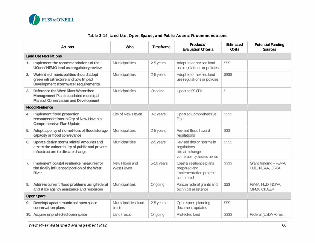
West River Watershed Management Plan 60
Table 3-14. Land Use, Open Space, and Public Access Recommendations
Actions Who Timeframe Products/Evaluation Criteria
EstimatedCosts
Potential FundingSources
Land Use Regulations
1. Implement the recommendations of theUConn/NEMO land use regulatory review
Municipalities 2-5 years Adopted or revised landuse regulations or policies
$$$
2. Watershed municipalities should adoptgreen infrastructure and Low ImpactDevelopment stormwater requirements
Municipalities 2-5 years Adopted or revised landuse regulations or policies
$$$$
3. Reference the West River WatershedManagement Plan in updated municipalPlans of Conservation and Development
Municipalities Ongoing Updated POCDs $
Flood Resilience
4. Implement flood protectionrecommendations in City of New Haven’sComprehensive Plan Update
City of New Haven 0-2 years Updated ComprehensivePlan
$$$$
5. Adopt a policy of no-net-loss of flood storagecapacity or flood conveyance
Municipalities 2-5 years Revised flood hazardregulations
$$$
6. Update design storm rainfall amounts andassess the vulnerability of public and privateinfrastructure to climate change
Municipalities 2-5 years Revised design storms inregulations,climate changevulnerability assessments
$$$$
7. Implement coastal resilience measures forthe tidally influenced portion of the WestRiver
New Haven andWest Haven
5-10 years Coastal resilience plansprepared andimplementation projectscompleted
$$$$ Grant funding – FEMA,HUD, NOAA, CIRCA
8. Address current flood problems using federaland state agency assistance and resources
Municipalities Ongoing Pursue federal grants andtechnical assistance
$$$ FEMA, HUD, NOAA,CIRCA, CTDEEP
Open Space
9. Develop/update municipal open spaceconservation plans
Municipalities, landtrusts
2-5 years Open space planningdocument updates
$$$
10. Acquire unprotected open space Land trusts, Ongoing Protected land $$$$ Federal (USDA Forest
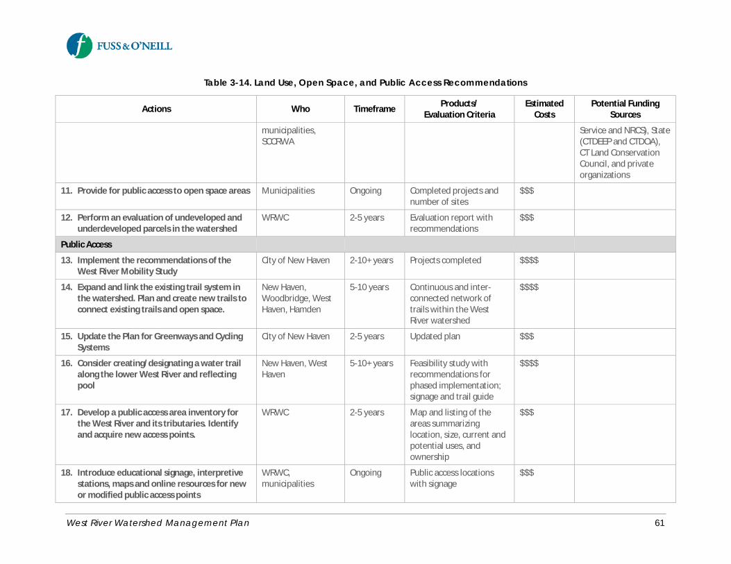
West River Watershed Management Plan 61
Table 3-14. Land Use, Open Space, and Public Access Recommendations
Actions Who Timeframe Products/Evaluation Criteria
EstimatedCosts
Potential FundingSources
municipalities,SCCRWA
Service and NRCS), State(CTDEEP and CTDOA),CT Land ConservationCouncil, and privateorganizations
11. Provide for public access to open space areas Municipalities Ongoing Completed projects andnumber of sites
$$$
12. Perform an evaluation of undeveloped andunderdeveloped parcels in the watershed
WRWC 2-5 years Evaluation report withrecommendations
$$$
Public Access
13. Implement the recommendations of theWest River Mobility Study
City of New Haven 2-10+ years Projects completed $$$$
14. Expand and link the existing trail system inthe watershed. Plan and create new trails toconnect existing trails and open space.
New Haven,Woodbridge, WestHaven, Hamden
5-10 years Continuous and inter-connected network oftrails within the WestRiver watershed
$$$$
15. Update the Plan for Greenways and CyclingSystems
City of New Haven 2-5 years Updated plan $$$
16. Consider creating/designating a water trailalong the lower West River and reflectingpool
New Haven, WestHaven
5-10+ years Feasibility study withrecommendations forphased implementation;signage and trail guide
$$$$
17. Develop a public access area inventory forthe West River and its tributaries. Identifyand acquire new access points.
WRWC 2-5 years Map and listing of theareas summarizinglocation, size, current andpotential uses, andownership
$$$
18. Introduce educational signage, interpretivestations, maps and online resources for newor modified public access points
WRWC,municipalities
Ongoing Public access locationswith signage
$$$
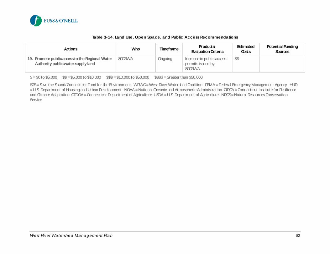
West River Watershed Management Plan 62
Table 3-14. Land Use, Open Space, and Public Access Recommendations
Actions Who Timeframe Products/Evaluation Criteria
EstimatedCosts
Potential FundingSources
19. Promote public access to the Regional WaterAuthority public water supply land
SCCRWA Ongoing Increase in public accesspermits issued bySCCRWA
$$
$ = $0 to $5,000 $$ = $5,000 to $10,000 $$$ = $10,000 to $50,000 $$$$ = Greater than $50,000
STS = Save the Sound/Connecticut Fund for the Environment WRWC = West River Watershed Coalition FEMA = Federal Emergency Management Agency HUD= U.S. Department of Housing and Urban Development NOAA = National Oceanic and Atmospheric Administration CIRCA = Connecticut Institute for Resilienceand Climate Adaptation CTDOA = Connecticut Department of Agriculture USDA = U.S. Department of Agriculture NRCS = Natural Resources ConservationService
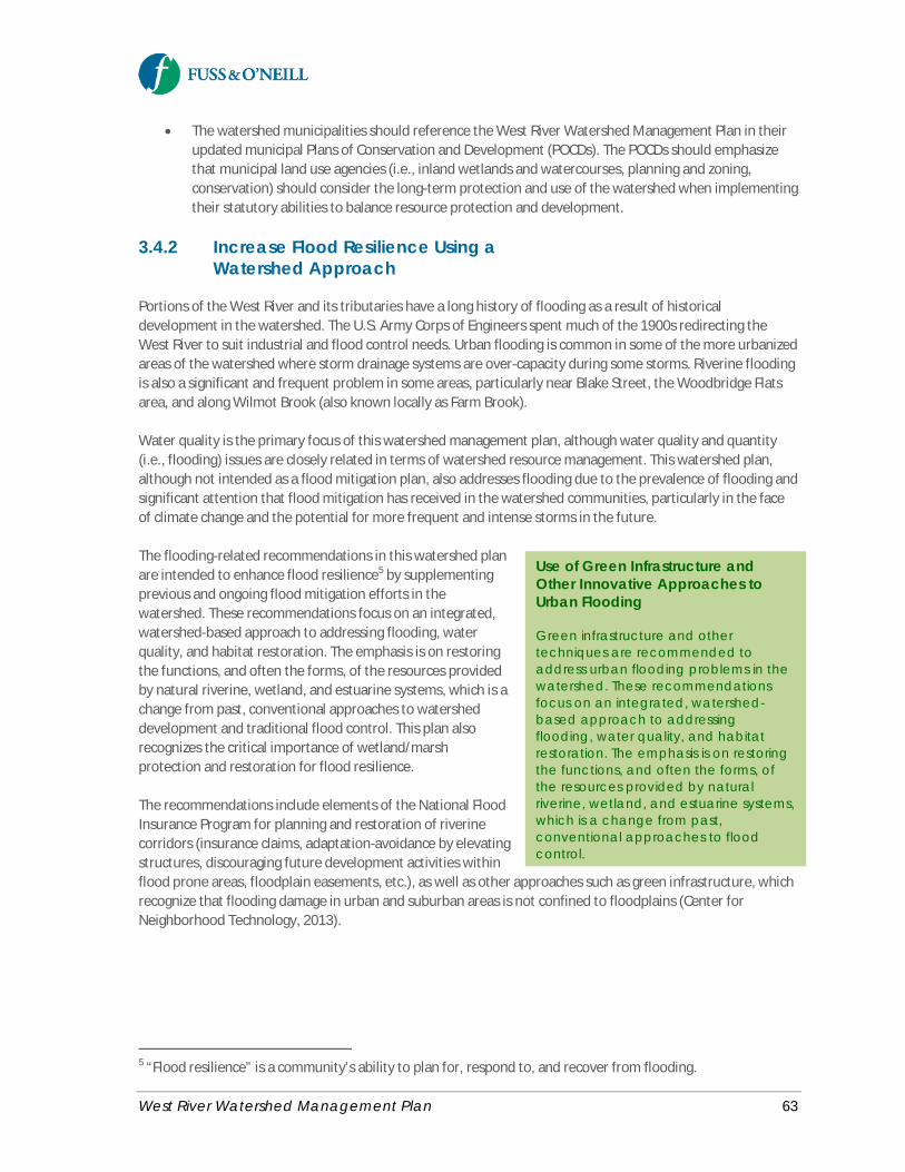
West River Watershed Management Plan 63
· The watershed municipalities should reference the West River Watershed Management Plan in theirupdated municipal Plans of Conservation and Development (POCDs). The POCDs should emphasizethat municipal land use agencies (i.e., inland wetlands and watercourses, planning and zoning,conservation) should consider the long-term protection and use of the watershed when implementingtheir statutory abilities to balance resource protection and development.
3.4.2 Increase Flood Resilience Using aWatershed Approach
Portions of the West River and its tributaries have a long history of flooding as a result of historicaldevelopment in the watershed. The U.S. Army Corps of Engineers spent much of the 1900s redirecting theWest River to suit industrial and flood control needs. Urban flooding is common in some of the more urbanizedareas of the watershed where storm drainage systems are over-capacity during some storms. Riverine floodingis also a significant and frequent problem in some areas, particularly near Blake Street, the Woodbridge Flatsarea, and along Wilmot Brook (also known locally as Farm Brook).
Water quality is the primary focus of this watershed management plan, although water quality and quantity(i.e., flooding) issues are closely related in terms of watershed resource management. This watershed plan,although not intended as a flood mitigation plan, also addresses flooding due to the prevalence of flooding andsignificant attention that flood mitigation has received in the watershed communities, particularly in the faceof climate change and the potential for more frequent and intense storms in the future.
The flooding-related recommendations in this watershed planare intended to enhance flood resilience5 by supplementingprevious and ongoing flood mitigation efforts in thewatershed. These recommendations focus on an integrated,watershed-based approach to addressing flooding, waterquality, and habitat restoration. The emphasis is on restoringthe functions, and often the forms, of the resources providedby natural riverine, wetland, and estuarine systems, which is achange from past, conventional approaches to watersheddevelopment and traditional flood control. This plan alsorecognizes the critical importance of wetland/marshprotection and restoration for flood resilience.
The recommendations include elements of the National FloodInsurance Program for planning and restoration of riverinecorridors (insurance claims, adaptation-avoidance by elevatingstructures, discouraging future development activities withinflood prone areas, floodplain easements, etc.), as well as other approaches such as green infrastructure, whichrecognize that flooding damage in urban and suburban areas is not confined to floodplains (Center forNeighborhood Technology, 2013).
5 “Flood resilience” is a community’s ability to plan for, respond to, and recover from flooding.
Use of Green Infrastructure andOther Innovative Approaches toUrban Flooding
Green infrastructure and othertechniques are recommended toaddress urban flooding problems in thewatershed. These recommendationsfocus on an integrated, watershed-based approach to addressingflooding, water quality, and habitatrestoration. The emphasis is on restoringthe functions, and often the forms, ofthe resources provided by naturalriverine, wetland, and estuarine systems,which is a change from past,conventional approaches to floodcontrol.

West River Watershed Management Plan 64
Recommended Actions· Implement the flood protection recommendations in the City of New Haven’s Comprehensive Plan
Update:o Continue to restrict land clearing activities and development in low-lying areas through the
enforcement of the city’s floodplain ordinanceso Encourage flood proofing of structures in areas prone to repetitive floods. Identify and seek
pre-disaster mitigation funding and other sources of funding available at the state andfederal level to implement flood proofing measures within the city.
o Review, assess, and revise the floodplain ordinances of the city periodically to protect thehealth, safety, and welfare of residents.
o Delineate Base Flood Elevations (BFEs) at the parcel level, as designated by FEMA, on officialCity maps and publish them on City webpage so that they can be used by residents andpotential developers.
o Continue to update and adopt the City’s Natural Hazard Mitigation Plan (updated in 2010).
· Adopt a policy of no-net-loss of flood storage capacity or flood conveyance within the watershed.Preserve and protect existing wetlands that provide flood storage and attenuation.
· Remove, redesign and reduce in-channel and in-floodway structures and restore channels, floodwaysand floodplains. Restore floodplain storage by excavating fill and removing flood-prone structures.
· Emphasize infiltration using green infrastructure techniques, which provides water quality and otherbenefits in addition to flood mitigation.
· Incorporate updated design storm rainfall amountsinto local land use regulations and policies toaccount for the influence of climate change.
· Ensure that future flood mitigation projects anddesigns include provisions for water quality andriparian/aquatic habitat restoration. Provide ormaintain vegetated buffers around all watercoursesand wetlands where feasible.
· Assess the vulnerability of public and privateinfrastructure (e.g., utilities, transportation,structures) to climate change and increasedfrequency of extreme storms, sea level rise, etc. anddevelop adaptation strategies.
· Implement coastal resiliency measures, includingprotection of marshland, for areas along the tidallyinfluenced portions of the lower West River tomitigate adverse impacts of sea level rise and stormsurge.
· Engage federal and state agencies on availableassistance and resources to develop and implementengineering solutions to address flood problems.
Updated Design Storm Rainfall
The National Oceanic and AtmosphericAdministration National Weather Serviceis updating precipitation frequencydata (i.e., design storm rainfallamounts). A similar tool for updatedextreme precipitation data wasdeveloped as a joint collaborationbetween the Northeast RegionalClimate Center and the USDA NaturalResources Conservation Services,http://precip.eas.cornell.edu, for NewYork and New England. The designstorm rainfall amounts provided by thisweb tool offer significant advantagesover previous products (e.g., “RainfallFrequency Atlas of the United States”,Technical Paper No. 40, U.S.Department of Commerce, WeatherBureau and NOAA TechnicalMemorandum “NWS Hydro-35”, June1977, U.S. Department of Commerce,National Weather Service) since thedesign storm rainfall amounts are basedon a much longer period of record,including future updates as new rainfalldata is available.
West River Watershed Management Plan 65
3.4.3 Preserve and Protect Open Space
An objective of this plan is to manage, maintain, and promote existing open space and continue to protect andacquire open space that meets resource protection and recreational goals. Open space plays a critical role inprotecting and preserving the health of a watershed by limiting development and impervious coverage,preserving natural pollutant attenuation characteristics, and supporting other planning objectives such asfarmland preservation, community preservation, and passive recreation. Open space is also important ashabitat for native and migratory species and protection of public water supply, both significant uses of openspace in the West River watershed.
Open space in the West River watershed includes preserved natural areas (e.g., West Rock Ridge State Park andRegional Water Authority public water supply land) as well as lightly developed parks, playgrounds, andcemeteries. The watershed communities have identified open space protection goals and priorities primarilythrough their Plans of Conservation and Development.
Recommended Actions· The watershed municipalities should develop or update existing municipal open space conservation
plans. Update open space planning documents at least every five years.
· Work closely with land owners to protect and/or acquire unprotected open space as recommended inthis watershed based plan, the municipal Plans of Conservation and Development, and related openspace planning efforts.
· Continue to promote conservation easements as a tool to local or regional land trusts to protect,conserve, and maintain open space. Alternative funding sources and approaches for open spaceacquisition include state funding (e.g., Community Investment Act - Public Act 05-228), limited marketrate development on a parcel to help fund the acquisition of the remainder of the parcel as openspace, and transferring development rights from sensitive locations to locations better suited fordevelopment. Regardless of the mechanism, critical to the success of protecting open space land isthe ability to readily leverage financing when windows of opportunity arise to acquire or preservesignificant parcels.
· Plan and provide for public access to open space areas, and connect existing open spaces to avoidopen space fragmentation. Obtain public access easements from property owners to link open spaceareas. Partner with non-profit organizations such as the New Haven Land Trust to acquire adequatevacant lands or easements to create a linked network of trails within the West River watershed.
· Ensure that open spaces remain available for passive recreation. Promote awareness and appropriateuse of existing open space by publicizing parks, trails, community gardens, and historic landscapes aswell as educational events on open space parcels.
· Assess, improve, and restore parcels already acquired. Develop management plans for the use ofacquired open space parcels.
· Proposed open space acquisitions should be evaluated based on a set of criteria that considers theenvironmental and physical characteristics of each property proposed for acquisition. In general,priority for open space protection should be given to properties that meet one or more of thefollowing environmental criteria, in addition to multiple public benefits:
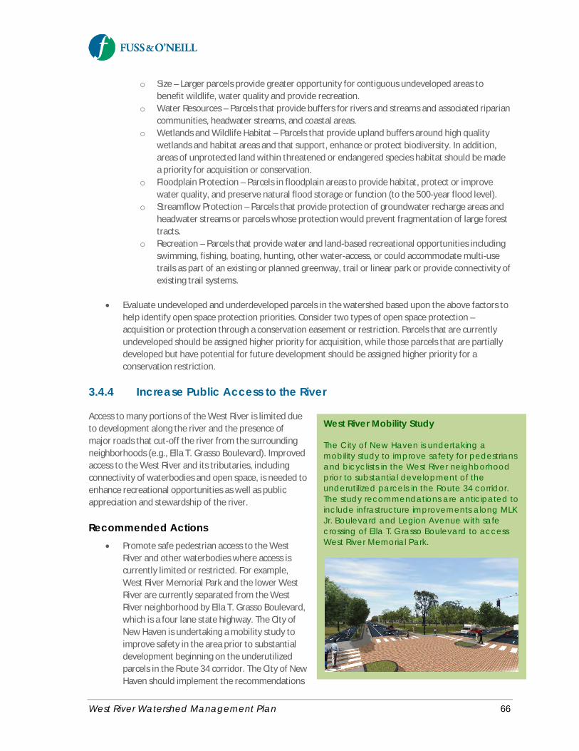
West River Watershed Management Plan 66
o Size – Larger parcels provide greater opportunity for contiguous undeveloped areas tobenefit wildlife, water quality and provide recreation.
o Water Resources – Parcels that provide buffers for rivers and streams and associated ripariancommunities, headwater streams, and coastal areas.
o Wetlands and Wildlife Habitat – Parcels that provide upland buffers around high qualitywetlands and habitat areas and that support, enhance or protect biodiversity. In addition,areas of unprotected land within threatened or endangered species habitat should be madea priority for acquisition or conservation.
o Floodplain Protection – Parcels in floodplain areas to provide habitat, protect or improvewater quality, and preserve natural flood storage or function (to the 500-year flood level).
o Streamflow Protection – Parcels that provide protection of groundwater recharge areas andheadwater streams or parcels whose protection would prevent fragmentation of large foresttracts.
o Recreation – Parcels that provide water and land-based recreational opportunities includingswimming, fishing, boating, hunting, other water-access, or could accommodate multi-usetrails as part of an existing or planned greenway, trail or linear park or provide connectivity ofexisting trail systems.
· Evaluate undeveloped and underdeveloped parcels in the watershed based upon the above factors tohelp identify open space protection priorities. Consider two types of open space protection –acquisition or protection through a conservation easement or restriction. Parcels that are currentlyundeveloped should be assigned higher priority for acquisition, while those parcels that are partiallydeveloped but have potential for future development should be assigned higher priority for aconservation restriction.
3.4.4 Increase Public Access to the River
Access to many portions of the West River is limited dueto development along the river and the presence ofmajor roads that cut-off the river from the surroundingneighborhoods (e.g., Ella T. Grasso Boulevard). Improvedaccess to the West River and its tributaries, includingconnectivity of waterbodies and open space, is needed toenhance recreational opportunities as well as publicappreciation and stewardship of the river.
Recommended Actions· Promote safe pedestrian access to the West
River and other waterbodies where access iscurrently limited or restricted. For example,West River Memorial Park and the lower WestRiver are currently separated from the WestRiver neighborhood by Ella T. Grasso Boulevard,which is a four lane state highway. The City ofNew Haven is undertaking a mobility study toimprove safety in the area prior to substantialdevelopment beginning on the underutilizedparcels in the Route 34 corridor. The City of NewHaven should implement the recommendations
West River Mobility Study
The City of New Haven is undertaking amobility study to improve safety for pedestriansand bicyclists in the West River neighborhoodprior to substantial development of theunderutilized parcels in the Route 34 corridor.The study recommendations are anticipated toinclude infrastructure improvements along MLKJr. Boulevard and Legion Avenue with safecrossing of Ella T. Grasso Boulevard to accessWest River Memorial Park.
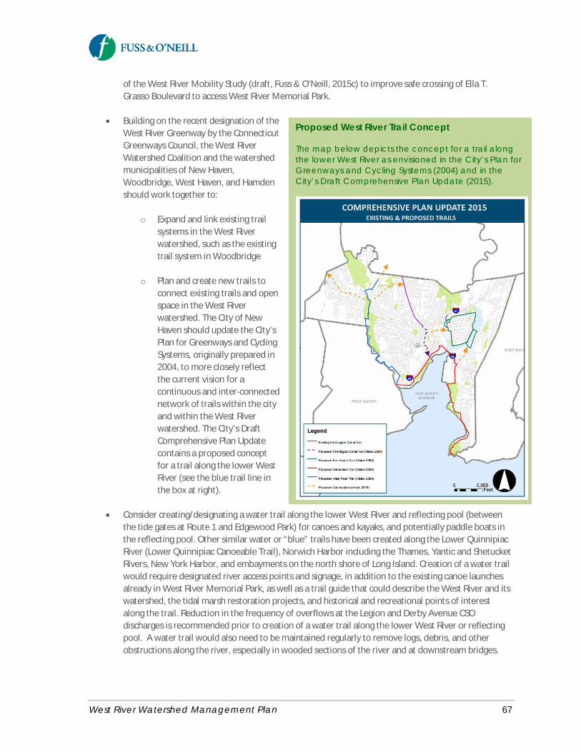
West River Watershed Management Plan 67
of the West River Mobility Study (draft, Fuss & O’Neill, 2015c) to improve safe crossing of Ella T.Grasso Boulevard to access West River Memorial Park.
· Building on the recent designation of theWest River Greenway by the ConnecticutGreenways Council, the West RiverWatershed Coalition and the watershedmunicipalities of New Haven,Woodbridge, West Haven, and Hamdenshould work together to:
o Expand and link existing trailsystems in the West Riverwatershed, such as the existingtrail system in Woodbridge
o Plan and create new trails toconnect existing trails and openspace in the West Riverwatershed. The City of NewHaven should update the City’sPlan for Greenways and CyclingSystems, originally prepared in2004, to more closely reflectthe current vision for acontinuous and inter-connectednetwork of trails within the cityand within the West Riverwatershed. The City’s DraftComprehensive Plan Updatecontains a proposed conceptfor a trail along the lower WestRiver (see the blue trail line inthe box at right).
· Consider creating/designating a water trail along the lower West River and reflecting pool (betweenthe tide gates at Route 1 and Edgewood Park) for canoes and kayaks, and potentially paddle boats inthe reflecting pool. Other similar water or “blue” trails have been created along the Lower QuinnipiacRiver (Lower Quinnipiac Canoeable Trail), Norwich Harbor including the Thames, Yantic and ShetucketRivers, New York Harbor, and embayments on the north shore of Long Island. Creation of a water trailwould require designated river access points and signage, in addition to the existing canoe launchesalready in West River Memorial Park, as well as a trail guide that could describe the West River and itswatershed, the tidal marsh restoration projects, and historical and recreational points of interestalong the trail. Reduction in the frequency of overflows at the Legion and Derby Avenue CSOdischarges is recommended prior to creation of a water trail along the lower West River or reflectingpool. A water trail would also need to be maintained regularly to remove logs, debris, and otherobstructions along the river, especially in wooded sections of the river and at downstream bridges.
Proposed West River Trail Concept
The map below depicts the concept for a trail alongthe lower West River as envisioned in the City’s Plan forGreenways and Cycling Systems (2004) and in theCity’s Draft Comprehensive Plan Update (2015).
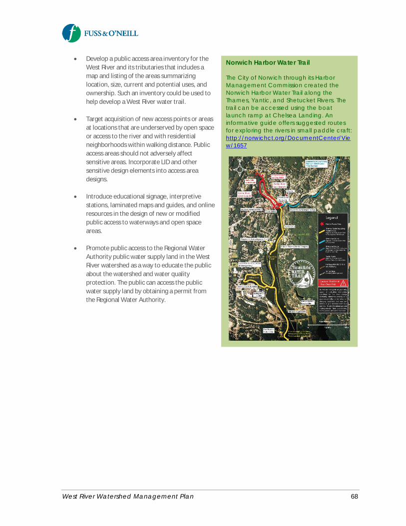
West River Watershed Management Plan 68
· Develop a public access area inventory for theWest River and its tributaries that includes amap and listing of the areas summarizinglocation, size, current and potential uses, andownership. Such an inventory could be used tohelp develop a West River water trail.
· Target acquisition of new access points or areasat locations that are underserved by open spaceor access to the river and with residentialneighborhoods within walking distance. Publicaccess areas should not adversely affectsensitive areas. Incorporate LID and othersensitive design elements into access areadesigns.
· Introduce educational signage, interpretivestations, laminated maps and guides, and onlineresources in the design of new or modifiedpublic access to waterways and open spaceareas.
· Promote public access to the Regional WaterAuthority public water supply land in the WestRiver watershed as a way to educate the publicabout the watershed and water qualityprotection. The public can access the publicwater supply land by obtaining a permit fromthe Regional Water Authority.
Norwich Harbor Water Trail
The City of Norwich through its HarborManagement Commission created theNorwich Harbor Water Trail along theThames, Yantic, and Shetucket Rivers. Thetrail can be accessed using the boatlaunch ramp at Chelsea Landing. Aninformative guide offers suggested routesfor exploring the rivers in small paddle craft:http://norwichct.org/DocumentCenter/View/1657
West River Watershed Management Plan 69
Goal Statement: Promote stewardship of the watershed through education and outreach, improved access to the WestRiver and its tributaries, and citizen involvement in science, conservation, and restoration activities.
3.5 Education and Outreach
A goal of this watershed plan is to modify the behaviors of individuals and the public to affect a positive changein the watershed. Often, the public is not aware of the impacts that their every-day activities can have on waterquality. Public education is critical to the long-term success of watershed management because it raisesawareness and reminds people of the individual actions they can take to protect and improve water quality intheir watershed. This increased understanding has the additional benefit of fostering support for watershedmanagement efforts and cultivating a long-term environmental watershed stewardship ethic, particularly withrespect to the benefits of green infrastructure.
The education and outreach recommendations of this watershed plan are targeted at reaching four primaryaudiences, in addition to other stakeholder groups:
· Homeowners· Municipalities and volunteer groups· Students (K-12)/higher education· Businesses and industry
Education and outreach recommendations that are tailored to these audiences are described in the followingsections. Watershed public outreach and educational programs should build upon the successful programs andmodels that already exist in the watershed, elsewhere in Connecticut, and nationally.
Table 3-15 summarizes education and outreach recommendations for the West River watershed.
3.5.1 Implement a Public OutreachCampaign
The West River Watershed Coalition, working with local and regional partners including Save the Sound,CTDEEP, the watershed municipalities and GNHWPCA, should consider developing and implementing awatershed-based green infrastructure public outreach campaign6 for the West River (or a regional effort for theGreater New Haven watersheds including the West River, Quinnipiac River, and Mill River) focused on citizens,businesses, and communities. The public outreach campaign could be developed based on other successfulmodels such as EPA’s “Soak Up the Rain” program or the award-winning “Save the Rain” initiative in OnondagaCounty (Syracuse), New York. Startup funding for such a campaign may be possible through CTDEEP,particularly if the campaign is developed/designed to be transferable to other watersheds or organizations orfor use statewide.
Key aspects of developing a successful outreach campaign include identifying and analyzing the targetaudiences, drafting an effective message and branding the program, and packaging and delivering the messagethrough a variety of media. EPA’s Getting In Step: A Guide for Conducting Watershed Outreach Campaigns(2010) is an excellent resource for developing and implementing a successful program.
6 A campaign is not a single product or event, but rather a suite of activities, materials, and distribution formatsthat are carefully coordinated to achieve specific goals and objectives.
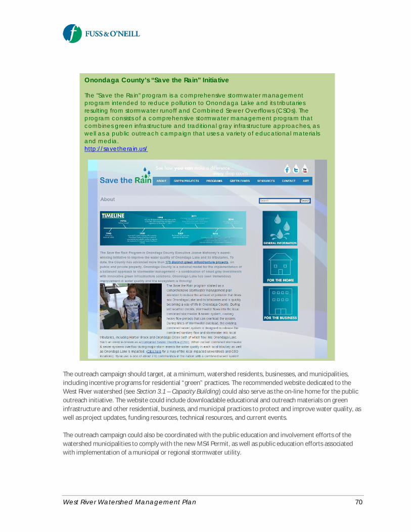
West River Watershed Management Plan 70
The outreach campaign should target, at a minimum, watershed residents, businesses, and municipalities,including incentive programs for residential “green” practices. The recommended website dedicated to theWest River watershed (see Section 3.1 – Capacity Building) could also serve as the on-line home for the publicoutreach initiative. The website could include downloadable educational and outreach materials on greeninfrastructure and other residential, business, and municipal practices to protect and improve water quality, aswell as project updates, funding resources, technical resources, and current events.
The outreach campaign could also be coordinated with the public education and involvement efforts of thewatershed municipalities to comply with the new MS4 Permit, as well as public education efforts associatedwith implementation of a municipal or regional stormwater utility.
Onondaga County’s “Save the Rain” Initiative
The "Save the Rain" program is a comprehensive stormwater managementprogram intended to reduce pollution to Onondaga Lake and its tributariesresulting from stormwater runoff and Combined Sewer Overflows (CSOs). Theprogram consists of a comprehensive stormwater management program thatcombines green infrastructure and traditional gray infrastructure approaches, aswell as a public outreach campaign that uses a variety of educational materialsand media.http://savetherain.us/
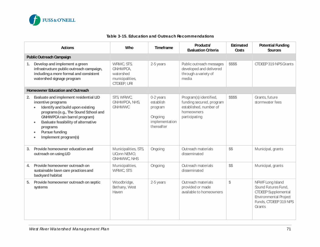
West River Watershed Management Plan 71
Table 3-15. Education and Outreach Recommendations
Actions Who Timeframe Products/Evaluation Criteria
EstimatedCosts
Potential FundingSources
Public Outreach Campaign
1. Develop and implement a greeninfrastructure public outreach campaign,including a more formal and consistentwatershed signage program
WRWC, STS,GNHWPCA,watershedmunicipalities,CTDEEP, URI
2-5 years Public outreach messagesdeveloped and deliveredthrough a variety ofmedia
$$$$ CTDEEP 319 NPS Grants
Homeowner Education and Outreach
2. Evaluate and implement residential LIDincentive programs· Identify and build upon existing
programs (e.g., The Sound School andGNHWPCA rain barrel program)
· Evaluate feasibility of alternativeprograms
· Pursue funding· Implement program(s)
STS, WRWC,GNHWPCA, NHS,GNHWWC
0-2 yearsestablishprogram
Ongoingimplementationthereafter
Program(s) identified,funding secured, programestablished, number ofhomeownersparticipating
$$$$ Grants, futurestormwater fees
3. Provide homeowner education andoutreach on using LID
Municipalities, STS,UConn NEMO,GNHWWC, NHS
Ongoing Outreach materialsdisseminated
$$ Municipal, grants
4. Provide homeowner outreach onsustainable lawn care practices andbackyard habitat
Municipalities,WRWC, STS
Ongoing Outreach materialsdisseminated
$$ Municipal, grants
5. Provide homeowner outreach on septicsystems
Woodbridge,Bethany, WestHaven
2-5 years Outreach materialsprovided or madeavailable to homeowners
$ NFWF Long IslandSound Futures Fund,CTDEEP SupplementalEnvironmental ProjectFunds, CTDEEP 319 NPSGrants

West River Watershed Management Plan 72
Table 3-15. Education and Outreach Recommendations
Actions Who Timeframe Products/Evaluation Criteria
EstimatedCosts
Potential FundingSources
Outreach to Municipalities and Volunteer Groups
6. Provide education and training formunicipal employees, land use boards, andbuilding inspectors
Municipalities (aspart of MS4 Permitoutreach)
2016-2021 (5-year permitterm)
Outreach completed asdocumented in MS4annual Reports
$$ Municipal funds(permit requirementsnot eligible forstate/federal funding)
Cost efficienciesthrough participation ina regional stormwatercoalition
7. Provide education and outreach tovolunteers of local non-profit organizations· Friends of Edgewood Park· Friends of Beaver Ponds Park· Watershed associations· Greater New Haven Waterworks
Coalition
STS, URI,municipalities (aspart of MS4 Permitoutreach)
2016-2021 (5-year permitterm)
Outreach eventscompleted
$$
Outreach to Business Community
8. Conduct outreach to commercial andindustrial property owners
Municipalities (aspart of MS4 Permitoutreach)
2016-2021 (5-year permitterm)
Outreach completed asdocumented in MS4annual Reports
$$ Municipal funds(permit requirementsnot eligible forstate/federal funding)
Cost efficienciesthrough participation ina regional stormwatercoalition
Outreach to Institutional Property Owners
9. Conduct workshops on best practices forinstitutional facilities for water qualityprotection
WRWC, STS,CTDEEP, Collegesand Universities
2-5 years Workshops developedand conducted
$$$ Grants
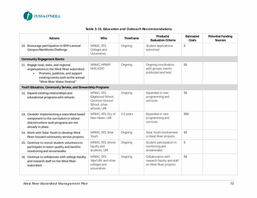
West River Watershed Management Plan 73
Table 3-15. Education and Outreach Recommendations
Actions Who Timeframe Products/Evaluation Criteria
EstimatedCosts
Potential FundingSources
10. Encourage participation in EPA’s annualCampus RainWorks Challenge
WRWC, STS,Colleges andUniversities
Ongoing Student applicationssubmitted
$
Community Engagement Events
11. Engage local, state, and regionalorganizations in the West River watershed
· Promote, publicize, and supportexisting events such as the annual“West River Water Festival”
WRWC, WRWP,NHS, ECPC
Ongoing Ongoing coordinationwith groups, eventspublicized and held
$$
Youth Education, Community Service, and Stewardship Programs
12. Expand existing relationships andeducational programs with schools
WRWC, STS,Edgewood School,Common GroundSchool, otherschools, URI
Ongoing Expanded or newprogramming andcurricula
$$
13. Consider implementing a watershed-basedcomponent to the curriculum in schooldistricts where such programs are notalready in place.
WRWC, STS, City ofNew Haven, URI
2-5 years Expanded or newprogramming andcurricula
$$$
14. Work with Solar Youth to develop WestRiver-focused community service projects
WRWC, STS, SolarYouth
Ongoing Solar Youth involvementin West River projects
$$
15. Continue to recruit student volunteers toparticipate in water quality and benthicmonitoring and streamwalks
WRWC, STS, schoolfaculty andstudents, URI
Ongoing Student participation inmonitoring andstreamwalks
$
16. Continue to collaborate with college facultyand research staff on the West Riverwatershed
WRWC, STS,Yale/URI, and othercolleges anduniversities
Ongoing Collaboration withresearch faculty and staffon West River projects
$$
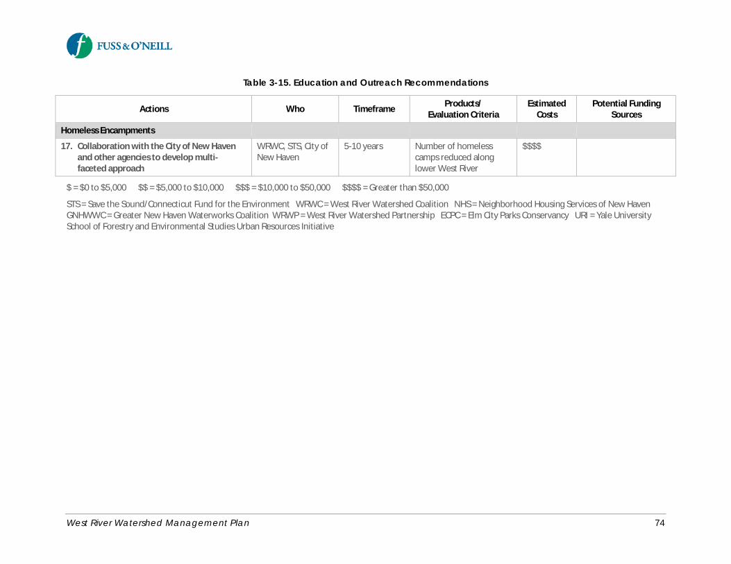
West River Watershed Management Plan 74
Table 3-15. Education and Outreach Recommendations
Actions Who Timeframe Products/Evaluation Criteria
EstimatedCosts
Potential FundingSources
Homeless Encampments
17. Collaboration with the City of New Havenand other agencies to develop multi-faceted approach
WRWC, STS, City ofNew Haven
5-10 years Number of homelesscamps reduced alonglower West River
$$$$
$ = $0 to $5,000 $$ = $5,000 to $10,000 $$$ = $10,000 to $50,000 $$$$ = Greater than $50,000
STS = Save the Sound/Connecticut Fund for the Environment WRWC = West River Watershed Coalition NHS = Neighborhood Housing Services of New HavenGNHWWC = Greater New Haven Waterworks Coalition WRWP = West River Watershed Partnership ECPC = Elm City Parks Conservancy URI = Yale UniversitySchool of Forestry and Environmental Studies Urban Resources Initiative
West River Watershed Management Plan 75
3.5.2 Homeowner Education and Outreach
An objective of the watershed plan is to build awareness of land stewardship and management practices andreduce water quality impacts associated with residential land use, which comprises approximately 36% of thewatershed land area. Successful homeowner outreach programs have been developed by other watershedgroups, including the Norwalk River Watershed Initiative (NRWI). A number of good educational brochures forhomeowners are available on the NRWI websitehttp://conservect.org/southwest/Education/tabid/267/itemid/121/Default.aspx.
Encourage the use of Residential LID PracticesHomeowners should be encouraged to implement green infrastructure or Low Impact Development (LID)practices on their properties.
· Encourage disconnection of rooftop runoff from the storm drainage system and impervious areas toreduce the quantity of runoff by redirecting the runoff to pervious lawn areas, through the use of drywells, or through the use of rain barrels or rain gardens.
· Provide education and outreach to homeowners, neighborhood groups, and roofing contractors ondisconnecting roof downspouts and installing and maintaining residential rain gardens and rainbarrels. The Connecticut NEMO web site provides a wealth of information about residential raingardens: http://nemo.uconn.edu/tools/stormwater/rain_garden.htm
· Provide residential LID incentive programs such as those described in Section 3.2.4 of this plan.
Promote Sustainable Lawn Care Practices – Homeowners and Lawn CareProfessionalsHomeowners should be encouraged to use environmentally-friendly lawn care practices such as reducing oreliminating fertilizer and pesticide usage through the use of slow release fertilizers and fertilizer applicationtiming; utilizing alternative landscaping that decreases maintenance; soil testing and non-chemical lawn caremeasures. Although sustainable lawn care practices will not significantly reduce bacteria loadings, they willreduce nutrient loadings, the use of toxic chemicals, and promote water conservation.
Extensive educational materials are available on these topics, including:
· CTDEEP Organic Lawn Care website:http://www.ct.gov/deep/cwp/view.asp?A=2708&Q=382644
· CTDEEP Transitioning To Organic Land Care (OLC) In Your Townhttp://www.ct.gov/deep/cwp/view.asp?a=2708&q=379676&deepNav_GID=1763
· Connecticut Chapter of the Northeast Organic Farming Associationhttp://www.organiclandcare.net/
· Southwest Conservations Districthttp://conservect.org/southwest/Education/tabid/267/itemid/121/Default.aspx
Other resources include the EPA’s GreenScape program, and more locally, the UCONN Cooperative ExtensionSystem’s Home & Garden Education Center. The Home & Garden Education Center’s web site, along withinformation on their soil testing services can be found at: http://www.ladybug.uconn.edu/index.htmlRecognizing the trend toward greater use of professional lawn care services by homeowners, outreach to locallandscapers and lawn care companies is an essential element of a successful lawn care outreach program.
West River Watershed Management Plan 76
Potential outreach programs, which could be developed in partnership with local land trusts and garden clubs,could include:
· Identifying and promoting sustainable landscape provider certification programs· Developing a placard campaign to identify lawns that implement preferred practices· Develop a sustainable lawn care and gardening recognition and incentive program, with landscapers
and homeowners highlighted on a rotating basis, or institute an alternative landscape competition.The Environmental Concerns Coalition of Milford, Connecticut, has developed a very successfulorganic lawn care competition and incentive program called “Freedom Lawns.” A Freedom Lawnbrochure developed by the Farmington River Watershed Association can be found at:http://www.frwa.org/publications/freedomlawntips.pdf. Another successful homeowner incentiveprogram has been developed by Lake Champlain International called the BLUE® Certification Program,which can be found at: http://www.mychamplain.net/blue-program.
· Implement a public awareness campaign modeled after the City of Middletown’s Project Green Lawnto encourage residents and businesses to eliminate lawn chemicals.http://www.cityofmiddletown.com/content/117/121/167/1862/486.aspx
Promote Backyard HabitatAs discussed in Section 3.2.10, encourage the creation of backyard buffers in residential areas near streamcorridors, including the importance of maintaining healthy vegetated buffers to streams, ponds, and wetlands,and recognize the efforts of the public.
· Educate homeowners about the value and importance of stream buffers by building on existingstream buffer outreach and educational programming (e.g., public recognition programs forcooperating landowners, Streamside Landowners’ Guide to the Quinnipiac Greenway, Audubon’sbackyard program, and programs from the EPA- Long Island Sound Study and Connecticut Sea Grant).
Provide Homeowner Outreach on Septic SystemsAs described in Section 3.2.6, provide homeowners in Woodbridge and Bethany educational materials on howto identify improperly functioning septic systems and procedures to have systems inspected, cleaned, andrepaired or upgraded. Septic system educational materials offered by The Quinnipiack Valley Health District(QVHD), which serves Bethany, Woodbridge, and Hamden, should be disseminated by these towns tohomeowners in their respective communities, which could also be used to meet the public outreach/educationminimum control measure of the MS4 Permit and the related municipal stormwater management plans.
Increase Watershed Stewardship SignageStewardship signage can increase public awareness and visibility of the West River and the connectionbetween the community, the watershed, and the river. Watershed signage can take the form of kiosks in publicareas, storm drain markers or stencils, anti-dumping signs, proper pet waste management signs, androadside/stream side signage (examples include “adopt a stream/roadway” programs). Storm drain stencilingand other watershed signs are already present in some areas of the watershed.
The West River Watershed Coalition and local partners should consider developing a more formal andconsistent watershed sign program that could be implemented as a component of the recommended greeninfrastructure public outreach program. The signs should incorporate a simple, yet consistent message andlogo. Watershed signs are recommended in highly-visible public areas of the watershed such as municipal

West River Watershed Management Plan 77
facilities (schools, parks, libraries, other municipal properties, commercial areas, etc.) and public access areasalong the river.
3.5.3 Outreach to Municipalities andVolunteer Groups
A key objective of this plan is to advance local government awareness, understanding, and stewardship of theWest River watershed. Ongoing outreach to municipal departments, staff, and volunteer board members is animportant element of municipal stormwater management programs, as required by the MS4 Permit. Suggestedtopics include common municipal activities and operations that can impact bacteria loads to the West Riverincluding parks and open space maintenance, green infrastructure and LID, storm sewer system and BMPmaintenance, and identification and removal of illicit connections.
· Municipalities should provide annual pollution prevention and good housekeeping training for allmunicipal employees whose activities potentially impact stormwater and water quality. The trainingshould include municipal personnel with responsibility for public works, parks and recreation, buildingmaintenance, lakes and pond management, and water/wastewater.
· Provide training for municipal reviewers (municipal land use commissions and boards, planners, etc.)of land development projects and designers (developers, architects, engineers, contractors, etc.).Suggested training topics include stream buffer protection, LID and green infrastructure, andconstruction erosion and sediment controls.
· Building inspectors in Connecticut must earn a requisite amount of continuing education credits eachyear. Existing training programs often do not address stormwater, LID, green infrastructure or erosionand sedimentation control methods. Building inspectors in each watershed municipality should berequired to receive regular training on these topics. Additionally, training should also be required onsanitary sewer and stormwater connection inspections.
· Continue to invite and involve the municipal staff and land use board members in West Riverrestoration efforts, outreach events, and river clean-ups.
Ongoing education and outreach to those that work as volunteers of local stewardship groups is alsoimportant. Local volunteer-based nonprofit groups such as Friends of Edgewood Park, Friends of Beaver PondsPark, watershed associations, and the Greater New Haven Waterworks Coalition should provide opportunitiesfor their member volunteers to participate in seminars, presentations, and other training offered by groupssuch as Save the Sound/CT Fund for the Environment, Urban Resources Initiative and public educationprovided by the watershed municipalities to comply with the MS4 Permit.
3.5.4 Outreach to Business Community
Commercial businesses along the major transportation corridors and industrial facilities in the lower WestRiver watershed, whether located directly adjacent to the river or in upland areas of the watershed, contributestormwater runoff that ultimately reaches the West River. An objective of this plan is to advance local businessawareness, understanding, and stewardship of the West River watershed.`
· Provide outreach to commercial and industrial property owners in the watershed explaining how theiractivities contribute to the water quality impairments of the West River. Focus on activities thatcontribute bacteria to the West River, including dumpster and trash management issues.
West River Watershed Management Plan 78
· Continue to involve businesses in restoration efforts, outreach events, and river clean-ups.
3.5.5 Outreach to Institutional PropertyOwners
Management and maintenance practices at institutional facilities with large intensively managed lawn areasand expansive parking lots can have a significant impact on water quality. Many large institutional land ownersare located in the West River watershed (e.g., Yale University, Southern Connecticut State University,University of New Haven, and other public and private schools) and, therefore, play an important collectiverole in improving and protecting water quality.
· The West River Watershed Coalition should consider partnering with STS, CTDEEP, and the collegesand universities in the watershed to conduct workshops on best practices for institutional facilities forwater quality protection. Topics could include:
o Integrated Pest Management (IPM)o Turf management and low fertilizer usageo Protection and restoration of stream buffer areaso Parking lot and road maintenance (deicing, snow management)o Drainage system inspection and maintenance (catch basins, storm drains, stormwater BMPs)o Water quantity and flooding issueso Low Impact Development and green infrastructure approaches
· Encourage the colleges and universities in the watershed (faculty, students, and facilities) toparticipate in EPA’s annual Campus RainWorks Challenge, which is a national competition for studentteams to design an innovative green infrastructure project for their campus showing how managingstormwater at its source can benefit the campus community and the environment.http://water.epa.gov/infrastructure/greeninfrastructure/crw_challenge.cfm
3.5.6 Promote Community EngagementEvents
Community events focused on the West River and its watershed are also an effective way to provide publicoutreach and stewardship of the West River. There are many community groups and organizations involved inenvironmental and watershed-related activities in the greater New Haven area, providing a strong base of localsupport and interest in the West River.
· The West River Watershed Coalition should continue to engage the many local, state, and regionalorganizations with an interest in the West River watershed, including the organizations listed in Table3-2 and other groups.
· Promote, publicize, and support existing community engagement events that focus on the West Riverand its watershed such as the annual “West River Water Festival”.
West River Watershed Management Plan 79
3.5.7 Promote Youth Education,Community Service, and StewardshipPrograms
In addition to several colleges and universities, the West River watershed is also home to numerous public andprivate primary and secondary schools, many of which offer environmental education and community serviceprograms. These existing programs and resources provide an excellent opportunity to promote youtheducation on issues related to watersheds, water quality, and the West River.
· The West River Watershed Coalition and STS should continue and expand their existing relationshipsand educational programs at the Edgewood School (“Schoolyard Habitat Program”), Common GroundHigh School (streamwalk surveys and other programs), and other local schools. Other interestedschools in New Haven and schools in other watershed communities should be identified as potentialcandidates for involvement in the West River watershed restoration efforts.
· Consider implementing a watershed-based component to the curriculum in school districts wheresuch programs are not already in place. Use existing educational materials available through the EPA-Long Island Sound Study, Connecticut Sea Grant, CTDEEP, and area colleges. The curriculum couldcombine lessons, field activities, classroom experiments, and regional networking into learningactivities that build shared scientific knowledge and stewardship experiences. The Farmington RiverWatershed (FRWA) has developed a place-based environmental curriculum consisting of 30 lessonsfor teachers to use at the elementary, secondary, and high school levels to communicate about thecultural, historical, wildlife, and water resources of the Farmington River Watershed. The lessons,training, and a cross-walk to current state curriculum standards are available for teachers in thewatershed.
· Work with the New Haven nonprofit youth development and environmental education organizationSolar Youth to provide teenagers with opportunities for involvement in environmental service projectsrelated to the West River watershed. Develop West River-focused community service projects inconjunction with the Green Jobs Youth Development Program Coordinator.
· Continue to recruit student volunteers to participate in water quality and benthic monitoring andstreamwalks in the West River watershed.
· Continue to collaborate with college faculty and research staff on ongoing and future researchactivities focused on the West River watershed, such as the long-time research by Dr. Gaboury Benoitof Yale.
3.5.8 Address Homeless Encampments
Temporary or permanent homeless encampments along waterways where human waste is disposed can be acommon problem in highly urbanized areas with an urban stream corridor (ASCE, 2014). Homelessencampments along portions of the lower West River are a recognized problem and potential source of fecalindicator bacteria to the river. Homelessness is a serious social issue and sensitive public policy issue withoutan immediate or clear solution. Several options exist to begin to address this issue from a water qualitystandpoint, based on the experience of urban communities in other parts of the U.S.:
· Support of city shelters and services to reduce homelessness· Periodic cleanup of homeless camps near streams
West River Watershed Management Plan 80
· Police enforcement/sweeps· Providing public restrooms· Partnering with non-governmental organizations to address homelessness.
The Contra Costa County Flood Control and Water Conservation District in southern California undertook anextensive research project to understand the best approaches for addressing water quality pollution fromhomeless encampments (DeVuono-Powell 2013). The study found that collaboration with other agencies wasthe most effective approach for addressing the long-term concerns of homeless encampments (ASCE, 2014).
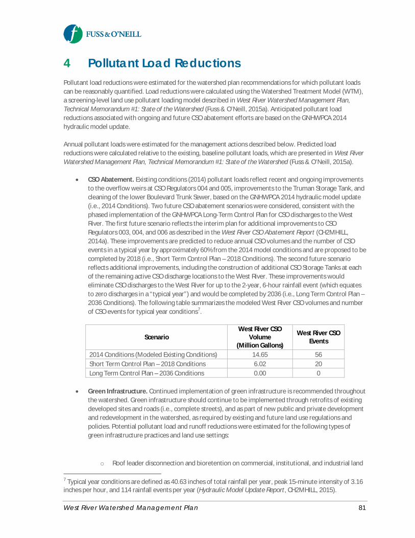
West River Watershed Management Plan 81
4 Pollutant Load ReductionsPollutant load reductions were estimated for the watershed plan recommendations for which pollutant loadscan be reasonably quantified. Load reductions were calculated using the Watershed Treatment Model (WTM),a screening-level land use pollutant loading model described in West River Watershed Management Plan,Technical Memorandum #1: State of the Watershed (Fuss & O’Neill, 2015a). Anticipated pollutant loadreductions associated with ongoing and future CSO abatement efforts are based on the GNHWPCA 2014hydraulic model update.
Annual pollutant loads were estimated for the management actions described below. Predicted loadreductions were calculated relative to the existing, baseline pollutant loads, which are presented in West RiverWatershed Management Plan, Technical Memorandum #1: State of the Watershed (Fuss & O’Neill, 2015a).
· CSO Abatement. Existing conditions (2014) pollutant loads reflect recent and ongoing improvementsto the overflow weirs at CSO Regulators 004 and 005, improvements to the Truman Storage Tank, andcleaning of the lower Boulevard Trunk Sewer, based on the GNHWPCA 2014 hydraulic model update(i.e., 2014 Conditions). Two future CSO abatement scenarios were considered, consistent with thephased implementation of the GNHWPCA Long-Term Control Plan for CSO discharges to the WestRiver. The first future scenario reflects the interim plan for additional improvements to CSORegulators 003, 004, and 006 as described in the West River CSO Abatement Report (CH2MHILL,2014a). These improvements are predicted to reduce annual CSO volumes and the number of CSOevents in a typical year by approximately 60% from the 2014 model conditions and are proposed to becompleted by 2018 (i.e., Short Term Control Plan – 2018 Conditions). The second future scenarioreflects additional improvements, including the construction of additional CSO Storage Tanks at eachof the remaining active CSO discharge locations to the West River. These improvements wouldeliminate CSO discharges to the West River for up to the 2-year, 6-hour rainfall event (which equatesto zero discharges in a “typical year”) and would be completed by 2036 (i.e., Long Term Control Plan –2036 Conditions). The following table summarizes the modeled West River CSO volumes and numberof CSO events for typical year conditions7.
· Green Infrastructure. Continued implementation of green infrastructure is recommended throughoutthe watershed. Green infrastructure should continue to be implemented through retrofits of existingdeveloped sites and roads (i.e., complete streets), and as part of new public and private developmentand redevelopment in the watershed, as required by existing and future land use regulations andpolicies. Potential pollutant load and runoff reductions were estimated for the following types ofgreen infrastructure practices and land use settings:
o Roof leader disconnection and bioretention on commercial, institutional, and industrial land
7 Typical year conditions are defined as 40.63 inches of total rainfall per year, peak 15-minute intensity of 3.16inches per hour, and 114 rainfall events per year (Hydraulic Model Update Report, CH2MHILL, 2015).
ScenarioWest River CSO
Volume(Million Gallons)
West River CSOEvents
2014 Conditions (Modeled Existing Conditions) 14.65 56Short Term Control Plan – 2018 Conditions 6.02 20Long Term Control Plan – 2036 Conditions 0.00 0
West River Watershed Management Plan 82
o Rain barrels and roof leader disconnection on residential propertieso Bioswales/bioretention and/or infiltration (subsurface infiltrators or trenches) for roadways.
Multiple scenarios were modeled to estimate the effect of varying levels of green infrastructureimplementation across the watershed, including estimates for retrofitting 10%, 25%, 50%, and 100%of the impervious area watershed-wide. The modeled effectiveness of the proposed retrofits wasreduced to reflect system maintenance and design (system bypass during larger storms) factors.
· Stream Buffer Restoration. Potential pollutant load reductions were estimated for restoration ofimpacted stream buffers in the watershed. The total length of streams within each subwatershed withimpacted buffers was estimated from land cover data. Under the modeled restoration scenario, a 100-foot vegetative streamside buffer was assumed for 50% of those areas currently with impactedbuffers (i.e., 50% restoration scenario).
· Reforestation. The watershed plan promotes preservation and enhancement of tree canopy throughvarious urban watershed forestry approaches. Potential pollutant load reduction benefits wereestimated for a watershed reforestation scenario using recommended tree canopy goals. Based on arecommendation of American Forests, 40% forest cover is a reasonable overall threshold goal fordeveloped watersheds, with 25% forest cover as a goal for urban areas and 50% forest cover forsuburban areas (American Forests, 2009). The amount of land conversion required to achieve therecommended tree canopy goals was modeled by converting existing developed land uses to aforested condition for subwatersheds that do not currently meet these goals (i.e., Lower West River,Beaver Brook, and Belden Brook subwatersheds).
· Public Education. Nonpoint source education programs can change behaviors that affect pollutantloads. Pollutant load reductions were estimated for pet waste education programs based on thenumber of dwellings, average fraction of pet-owners, pet-owners who already clean up after theirpets, and average fraction willing to change their behavior. Conservative model assumptions wereused to avoid over-estimating the load reduction benefits of these programs.
· Illicit Discharge Detection and Elimination. Illicit stormwater connection removal was considered ineach subwatershed based on the existing estimated number of illicit connections associated withcommercial and residential land uses. The illicit connection removal scenario conservatively assumesthat 15% of the existing illicit discharges are detected and eliminated.
· Septic System Repairs. Septic system repairs were considered in each subwatershed based on theexisting estimated number of households served by septic systems. The septic system repair scenarioassumes that 20% of the failing septic systems are repaired. This scenario reflects short or mid-termrecommendations to address existing failing or malfunctioning septic systems.
Other watershed management recommendations identified in this plan were not quantified due to theinherent limitations of screening-level pollutant load models and/or the lack of reliable information on thepollutant removal effectiveness of certain management measures.
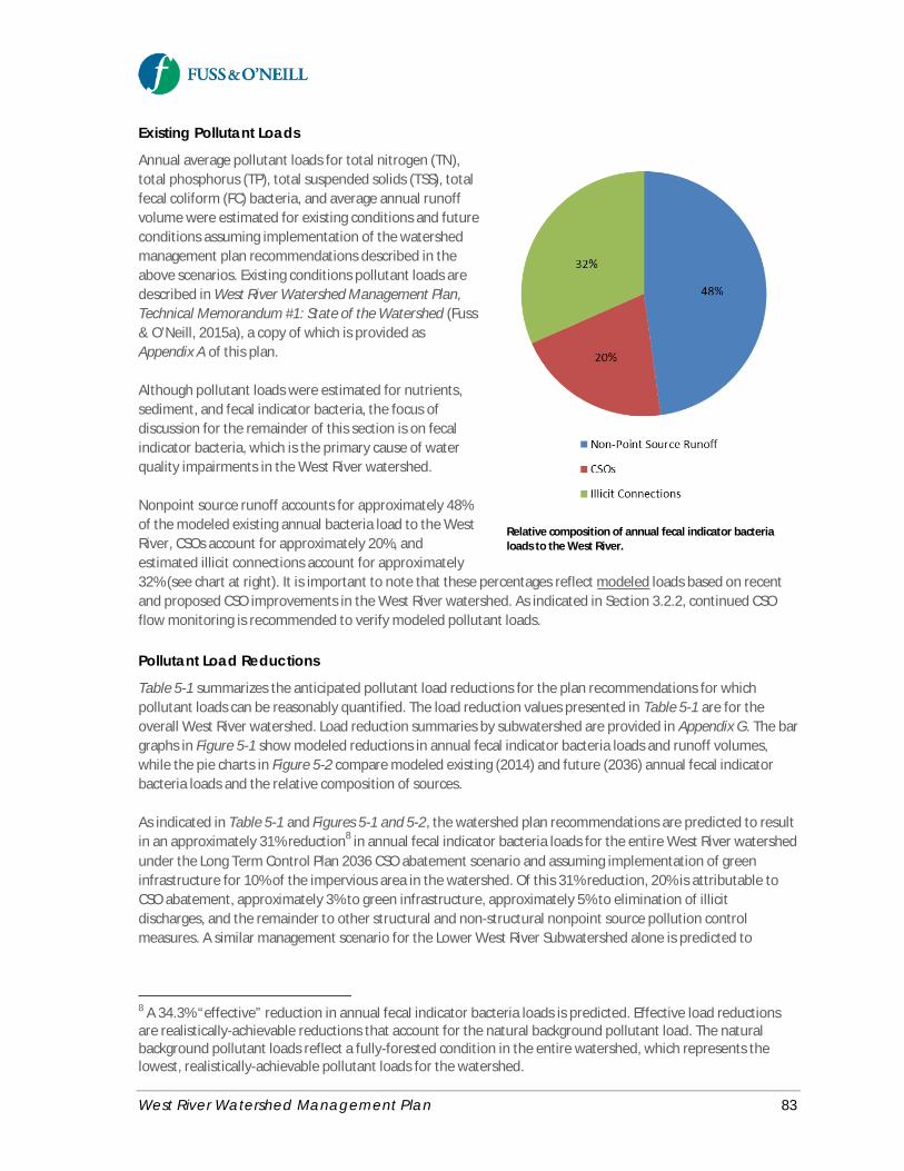
West River Watershed Management Plan 83
Relative composition of annual fecal indicator bacterialoads to the West River.
Existing Pollutant Loads
Annual average pollutant loads for total nitrogen (TN),total phosphorus (TP), total suspended solids (TSS), totalfecal coliform (FC) bacteria, and average annual runoffvolume were estimated for existing conditions and futureconditions assuming implementation of the watershedmanagement plan recommendations described in theabove scenarios. Existing conditions pollutant loads aredescribed in West River Watershed Management Plan,Technical Memorandum #1: State of the Watershed (Fuss& O’Neill, 2015a), a copy of which is provided asAppendix A of this plan.
Although pollutant loads were estimated for nutrients,sediment, and fecal indicator bacteria, the focus ofdiscussion for the remainder of this section is on fecalindicator bacteria, which is the primary cause of waterquality impairments in the West River watershed.
Nonpoint source runoff accounts for approximately 48%of the modeled existing annual bacteria load to the WestRiver, CSOs account for approximately 20%, andestimated illicit connections account for approximately32% (see chart at right). It is important to note that these percentages reflect modeled loads based on recentand proposed CSO improvements in the West River watershed. As indicated in Section 3.2.2, continued CSOflow monitoring is recommended to verify modeled pollutant loads.
Pollutant Load Reductions
Table 5-1 summarizes the anticipated pollutant load reductions for the plan recommendations for whichpollutant loads can be reasonably quantified. The load reduction values presented in Table 5-1 are for theoverall West River watershed. Load reduction summaries by subwatershed are provided in Appendix G. The bargraphs in Figure 5-1 show modeled reductions in annual fecal indicator bacteria loads and runoff volumes,while the pie charts in Figure 5-2 compare modeled existing (2014) and future (2036) annual fecal indicatorbacteria loads and the relative composition of sources.
As indicated in Table 5-1 and Figures 5-1 and 5-2, the watershed plan recommendations are predicted to resultin an approximately 31% reduction8 in annual fecal indicator bacteria loads for the entire West River watershedunder the Long Term Control Plan 2036 CSO abatement scenario and assuming implementation of greeninfrastructure for 10% of the impervious area in the watershed. Of this 31% reduction, 20% is attributable toCSO abatement, approximately 3% to green infrastructure, approximately 5% to elimination of illicitdischarges, and the remainder to other structural and non-structural nonpoint source pollution controlmeasures. A similar management scenario for the Lower West River Subwatershed alone is predicted to
8 A 34.3% “effective” reduction in annual fecal indicator bacteria loads is predicted. Effective load reductionsare realistically-achievable reductions that account for the natural background pollutant load. The naturalbackground pollutant loads reflect a fully-forested condition in the entire watershed, which represents thelowest, realistically-achievable pollutant loads for the watershed.

West River Watershed Management Plan 84
achieve a 49% reduction in annual fecal indicator bacteria loads to the impaired lower portion of the WestRiver.
Varying levels of green infrastructure implementation across the watershed were modeled, including the useof green infrastructure to manage runoff from 10%, 25%, 50%, and 100% of the impervious area in residential,industrial, commercial, institutional, and transportation land uses. The results for the 10% scenario, which isconsidered a reasonable likely future scenario, are included in Table 5-1. The results for all four scenarios arepresented in Table 5-2. The 10% retrofit scenario is predicted to result in an approximately 3% reduction inannual fecal indicator bacteria loads and 4% reduction in annual runoff volume. Higher bacteria loadreductions (up to approximately 27%) could potentially be achieved by implementing green infrastructure overa larger percentage of the watershed.
Illicit discharge detection and elimination (IDDE) is also predicted to result in annual bacteria load reductionscomparable to a 10% green infrastructure scenario. Even the modest 15% removal rate assumed in the modelis predicted to achieve an approximately 5% reduction in annual fecal indicator bacteria loads. IDDE issignificantly more cost-effective than implementing structural stormwater retrofits. Dry weather sources offecal indicator bacteria are the most likely to be identified and effectively managed and more likely to includehuman sources. Wet weather bacteria sources are often very costly to address and stream standards can bedifficult to attain, particularly with the presence of CSOs. IDDE and other source controls focusing on dryweather bacteria sources should be aggressively implemented through municipal stormwater managementprograms (as required by the MS4 permit) in conjunction with green infrastructure for wet weather sources.
Table 5-1. Modeled Annual Pollutant Load Reductions
Watershed ManagementRecommendation
Fecal Coliform(billion/year)
Fecal Coliform(%)
Runoff Volume(acre-feet/year)
Runoff Volume(%)
CSO Abatement (2036 levels) 548,800 20.6% -- --Green Infrastructure (10% ofimpervious area)
70,974 2.7% 801 3.7%
Riparian Buffer Restoration 10,996 0.4% 181 0.8%Reforestation 49,513 1.9% 871 4%Public Education 12,018 0.5% -- --Illicit Discharge Detectionand Elimination (IDDE)
126,561 4.7% -- --
Septic Repair 6,991 0.3% -- --Total 825,852 31.0% 1,854 8.6%
Table 5-2. Modeled Annual Pollutant Load Reductions for Varying Levels of GreenInfrastructure Implementation
Green InfrastructureImplementation Scenario
FecalColiform
(billion/year)
Fecal Coliform(%)
Runoff Volume(acre-feet/year)
RunoffVolume
(%)Retrofit 10% of Impervious Area 70,974 2.7% 801 3.7%Retrofit 25% of Impervious Area 177,435 6.7% 2,003 9.3%Retrofit 50% of Impervious Area 354,871 13.3% 4,007 18.6%Retrofit 100% of Impervious Area 709,741 26.6% 8,013 37.3%
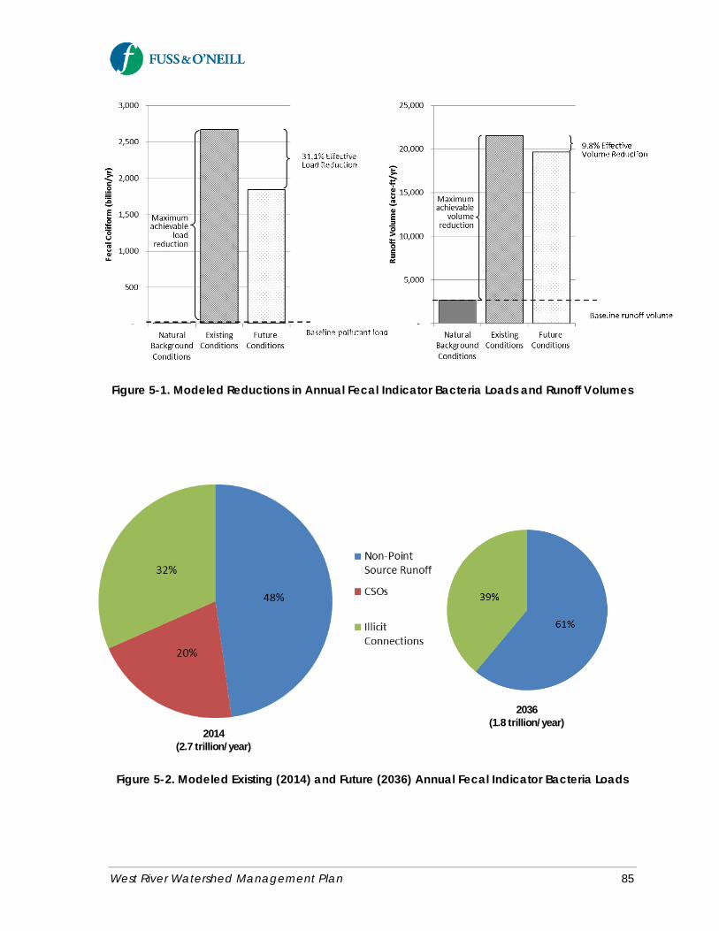
West River Watershed Management Plan 85
2014(2.7 trillion/year)
2036(1.8 trillion/year)
Figure 5-1. Modeled Reductions in Annual Fecal Indicator Bacteria Loads and Runoff Volumes
Figure 5-2. Modeled Existing (2014) and Future (2036) Annual Fecal Indicator Bacteria Loads
West River Watershed Management Plan 86
How Much will the Watershed Plan Recommendations Improve Water Quality?
The primary objective of this watershed plan is to address the water quality impairments in the West River andthereby restore the recreational uses and aquatic habitat that have been affected by poor water quality. Thepollutant load evaluation suggests that significant pollutant load and runoff reductions could be achieved byimplementing the plan recommendations. Implementation of the watershed management recommendations ispredicted to result in an approximately 31% to 49% reduction in annual fecal indicator bacteria loads to theWest River.
However, a logical question that arises from this evaluation is – if the watershed plan recommendations arefully implemented, will water quality in the West River consistently meet water quality standards for recreationand aquatic life?
A Total Maximum Daily Load (TMDL) analysis for fecal indicator bacteria was completed for the West River aspart of CTDEEP’s Statewide Bacteria TMDL. A TMDL is a “pollution budget” that identifies the reductions inpoint and nonpoint source pollution that are needed to meet Connecticut water quality standards for aparticular waterbody and a strategy to implement those reductions to restore water quality. The StatewideBacteria TMDL calls for an 86% reduction in fecal indicator bacteria loads (based on the geometric mean) to theimpaired segment of the West River. The pollutant load modeling results indicate that fecal indicator bacteriaload reductions of between 34% and 49% are achievable with full implementation of the watershedmanagement plan recommendations. This suggests that additional controls or more aggressive controlstrategies are needed to fully achieve the load reductions specified in the TMDL. Additional load reductionsmay be achieved through implementation of green infrastructure over a larger portion of the watershed,additional reforestation and stream buffer restoration, increasing the public awareness in the watershed ofcertain programs, and increased detection and elimination of illicit discharges.
It is important to note several limitations of both the TMDL load reduction estimates and the pollutant loadreduction modeling. The TMDL is based on very limited wet and dry weather monitoring data – 3 samplescollected in 1998 and 8 samples collected in 2010. The samples were also collected at locations upstream ofthe influence of CSOs. Furthermore, the TMDL and modeled load reductions are not directly comparable sincethe TMDL loads are daily, seasonal (i.e., worst-case) values, whereas the modeled pollutant loads are annualvalues. Lastly, the load reductions anticipated from CSO abatement efforts are not directly comparable to theTMDL load reduction goal since the TMDL was developed prior to the recent upgrades to the Boulevard TrunkSewer system, while the GNHWPCA 2014 Conditions hydraulic model accounts for these recent upgrades.Therefore, the modeled future CSO abatement load reductions are conservatively low when compared to theTMDL load reduction goals.
As indicated in the TMDL, progress in achieving TMDL-established goals through implementation of thiswatershed plan may be most effectively gauged through continued fixed-station ambient water qualitymonitoring. Routine monitoring should be performed at the same two sites used to generate the data for theTMDL calculations, as well as at additional sites along the West River (see the water quality monitoringrecommendations in Section 3.2 of this plan). Sampling should be scheduled at regularly spaced intervalsduring the recreational season. Therefore, the data set at the end of each season will include ambient valuesfor both “wet” and “dry” conditions in relative proportion to the number of “wet” and “dry” days that occurredduring the monitoring period. The TMDL calculations can be updated over time to compare the percentreductions needed under “dry” and “wet” conditions to the percent reductions that were needed at the time ofTMDL adoption.

West River Watershed Management Plan 87
5 Funding SourcesA variety of local, state, and federal sources are potentially available to provide funding for implementation ofthis watershed management plan, in addition to potential funds contributed by local grassroots organizationsand concerned citizens. Appendix H contains a list of potential funding sources and mechanisms. The table isnot intended to be an exhaustive list but can be used as a starting point to seek funding opportunities forimplementation of the recommendations in this watershed plan. The table of potential funding sources isintended to be a living document that should be updated periodically to reflect the availability of funding orchanges to the funding cycle, and to include other funding entities or grant programs.
West River Watershed Management Plan 88
6 ReferencesAmerican Forests. 2009. Setting urban tree canopy goals. Accessed May 1, 2009.http://www.americanforests.org/resources/urbanforests/treedeficit.php
American Society of Civil Engineers (ASCE), Urban Water Resources Research Council, 2014. Pathogens in WetWeather Flows Technical Committee Environmental and Water Resources Institute. Pathogens in UrbanStormwater. August 2014.
Bates, R., Carmalt, M., Gould R., & Roka, K., 2007. Management Plan for Beaver Pond Park.
Center for Neighborhood Technology (CNT). 2013. The Prevalence and Cost of Urban Flooding: A Case Study ofCook County, Illinois. May 2013.
Center for Neighborhood Technology (CNT) and American Rivers. 2010. The Value of Green Infrastructure: AGuide to Recognizing Its Economic, Environmental and Social Benefits.
CH2MHILL, 2014a. West River Combined Sewer Overflow Abatement Preliminary Design Memorandum.Prepared for Greater New Haven Water Pollution Control Authority CWF #668-PG. July 2014.
CH2MHILL, 2014b. Green Infrastructure Suitability Pilot Study. Prepared for Greater New Haven Water PollutionControl Authority Project CWF 2014-01 August 2014.
CH2MHILL, 2015. Hydraulic Model Update Report. Prepared for the Greater New Haven Water PollutionControl Authority. January 2015.
City of New Haven, 2010. City of New Haven Complete Streets Design Manual (Draft). March 2010.
City of New Haven, 2015. New Haven Vision 2025: A Plan for a Sustainable, Healthy, and Vibrant City (Draft).June 2015.
Connecticut Department of Energy and Environmental Protection (CTDEEP), 2008. Stream Crossing Guidelines.February 26, 2008.
Connecticut Department of Energy and Environmental Protection, Connecticut (CTDEEP). 2011. Canda Goose.http://www.ct.gov/dep/cwp/view.asp?A=2723&Q=325984
Connecticut Department of Energy and Environmental Protection (CTDEEP), 2012. Connecticut Statewide TotalMaximum Daily Load (TMDL) for Bacteria-Impaired Waters. Appendix A: West River Watershed TMDL: WestRiver and Edgewood Park Pond.
Connecticut Fund for the Environment/Save the Sound (CFE/STS), 2013. West River Final Monitoring ReportNew Haven, Connecticut September 2013.
DeVuono-Powell, S., 2013. Homeless Encampments in Contra Costa County. Contra Costa County Flood Controland Water Conservation District. Summer 2013.
West River Watershed Management Plan 89
Environmental Protection Agency, U.S. (EPA), 2010. Getting In Step: A Guide for Conducting WatershedOutreach Campaigns, 3rd edition. EPA 841-B-10-002. November 2010.
Environmental Protection Agency, U.S. (EPA), 2014. Coastal Stormwater Management Through GreenInfrastructure: A Handbook for Municipalities. EPA 842-R-14-004. December 2014.
Fuss & O’Neill, 2012. Stormwater Master Plan Southern Connecticut State University Master Plan Update, 2009Amendment. Southern Connecticut State University New Haven and Hamden, Connecticut. DCS Project # BI-RS-250.
Fuss & O’Neill, 2015a. West River Watershed Management Plan, Technical Memorandum #1: State of theWatershed. March 2015.
Fuss & O’Neill, 2015b. West River Watershed Management Plan, Technical Memorandum #2:GreenInfrastructure Assessment. June 4, 2015.
Fuss & O’Neill, 2015c. West River Mobility Study (Draft). June 2015.
Milone & MacBroom, 2002a. Environmental Review: West River Memorial Park Restoration, New Haven,Connecticut.
Milone & MacBroom, 2002b. Preliminary Engineering Study West River Memorial Park Tidal Marsh and RiverRestoration. New Haven, Connecticut. August 2002. MMI#1621-05-1.
Milone & MacBroom, 2011. Alternatives Analysis: Pond Lily Dam Removal West River New Haven, Connecticut.MM1#1899-08-5.
Milone & MacBroom, 2012. West River Tide Gate Monitoring. Inter-Office Memo, James G. MacBroom, P.E.November 30, 2012.
Mushinsky, M. 2015. Urban River Permits Review and Advocacy Recommendations for the Quinnipiac, Mill, andWest Rivers. Mill River Watershed Association of South Central Connecticut and River Advocates of SouthCentral Connecticut. April 2014, Revised June 2015.
U.S. Fish and Wildlife Service (FWS), 2014. Pond Lily Dam Removal. Accessed athttp://www.fws.gov/hurricane/sandy/projects/PondLilyDam.html.
U.S. Department of Agriculture Forest Service, 2005. Urban Watershed Forestry Manual - Part 1: Methods forIncreasing Forest Cover in a Watershed. U.S. Department of Agriculture Forest Service, Northeastern Area,State and Private Forestry, NA-TP-04-05; July 2005.

West River Watershed Management Plan
Appendix A
West River Watershed Management PlanTechnical Memorandum #1:
State of the Watershed (on CD)
West River Watershed Management Plan
Appendix B
Watershed Survey Responses
West River Watershed Management Plan
Appendix C
West River Watershed Management PlanTechnical Memorandum #2:
Green Infrastructure Assessment (on CD)

West River Watershed Management Plan
Appendix D
Project Steering Committee Meeting Summaries
West River Watershed Management Plan
Appendix E
Community Workshop Meeting Summaries
West River Watershed Management Plan
Appendix F
Streamwalk Assessment Training and Preliminary Results

West River Watershed Management Plan
Appendix G
Pollutant Load Reduction Model Results
West River Watershed Management Plan
Appendix H
Potential Funding Sources