west wirral - west wirral (dee estuary... · 3030 west wirral (dee estuary) west kirby is the start...
TRANSCRIPT

30 30
West Wirral (Dee Estuary)West Kirby is the start of the 12 mile long WirralWay, the ‘backbone’ of Wirral Country Park, the old Hooton to West Kirby railway line that closed in 1963.
This is a horse, cycle and pedestrian route, whichhas undergone a recent renovation, the pathprovides some wonderful views over the DeeEstuary to Wales. It passes the ThurstastonVisitor Centre being the Information Centre for
View of Hilbre Island from West Kirby with walkers at low tide.
3131
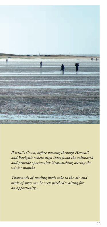
Wirral’s Coast, before passing through Heswalland Parkgate where high tides flood the saltmarshand provide spectacular birdwatching during thewinter months.
Thousands of wading birds take to the air andbirds of prey can be seen perched waiting for an opportunity…
32
West Wirral (Dee Estuary)
West Kirby - Caldy (Cubbins Green)
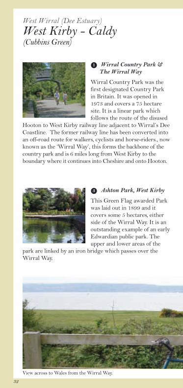
Wirral Country Park &The Wirral Way
Wirral Country Park was thefirst designated Country Parkin Britain. It was opened in1973 and covers a 75 hectaresite. It is a linear park whichfollows the route of the disused
Hooton to West Kirby railway line adjacent to Wirral’s DeeCoastline. The former railway line has been converted intoan off-road route for walkers, cyclists and horse-riders., nowknown as the ‘Wirral Way’, this forms the backbone of thecountry park and is 6 miles long from West Kirby to theboundary where it continues into Cheshire and onto Hooton.
Ashton Park, West Kirby
This Green Flag awarded Parkwas laid out in 1899 and itcovers some 5 hectares, eitherside of the Wirral Way. It is anoutstanding example of an earlyEdwardian public park. Theupper and lower areas of the
park are linked by an iron bridge which passes over theWirral Way.
1
3
View across to Wales from the Wirral Way.

33
Cubbins Green
A small grassland areafronting the Dee Estuary. A short path takes visitorsfrom the trail and ontoCubbins Green where you can access the beach. There is a small pond and picnic site
that affords spectacular views of West Kirby, HilbreIsland and the Dee Estuary across the mud flats to Wales.During the summer months, an abundance of wild flowerscan be found including the rare Bee Orchid. The area isideal for local birdwatching and sea fishing.
Caldy Golf Club
Stunning scenery and theglorious combination ofwonderful links and inlandholes make for a memorablegame of golf for players of allstandards. It has also been thescene of many major events
and was a qualifying course for the European Open.
2
4

34
West Wirral (Dee Estuary)
West Kirby - Caldy (Cubbins Green)
MarineLake
B5141
B5140
WIR
RA
L
CO
UN
TRY
PAR
K
20
18
17
Walkers only
grange rd
church rd
macdona
dr.
River Dee
ll
AshtonPark
CaldyHill
Caldy Golf Club
accessto beach
accessto beach
bridge
Morrisons
DawpoolNature Reserve
CubbinsGreen
Caldy
Thurstaston
1
2
4
3
1
melloncrof
t
drive
19
Anti-clockwise
Clockwise
© Crown copyright and database rights 2011. Ordnance Survey 100019803.

35
Anti-clockwise:West Kirby (Cubbins Green) - Caldy
From the Wirral Way at Cubbins Green,continue on for about half a mile to the Caldy car park.Cross the road and go up the short slope to rejoin theWirral Way and the trail. Continue straight on, passingalongside Caldy Golf Club.
Clockwise:Caldy - West Kirby (Cubbins Green)
By passing alongside Caldy Golf Club, continue tothe Caldy car park, cross the road and up the short slope torejoin the Wirral Way and trail. Continue along the trail toCubbins Green.
Opposite the entrance of Cubbins Green from the WirralWay is Melloncroft Drive that links directly to the publicfootpath network on Caldy Hill and Thurstaston Common.
18- 19
19 - 18
The beach at Cubbins Green.
36
West Wirral (Dee Estuary)
Thurstaston
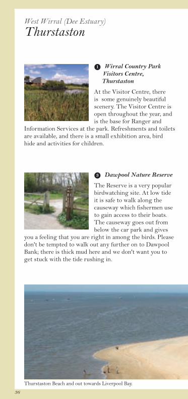
Dawpool Nature Reserve
The Reserve is a very popularbirdwatching site. At low tide it is safe to walk along thecauseway which fishermen useto gain access to their boats.The causeway goes out frombelow the car park and gives
you a feeling that you are right in among the birds. Pleasedon't be tempted to walk out any further on to DawpoolBank; there is thick mud here and we don't want you toget stuck with the tide rushing in.
3
Wirral Country ParkVisitors Centre, Thurstaston
At the Visitor Centre, thereis some genuinely beautifulscenery. The Visitor Centre isopen throughout the year, andis the base for Ranger and
Information Services at the park. Refreshments and toiletsare available, and there is a small exhibition area, birdhide and activities for children.
1
Thurstaston Beach and out towards Liverpool Bay.

37
The Dungeon
The Dungeon is a small,sheltered mature woodland ofoak, beech, sycamore and alder,with some scrub and heathland.The stream running throughthe steep sided valley forms anattractive waterfall where it
cascades over the sandstone bedrock. Trees provide shelterfor insects and woodland birds. The name is probably from the Old English dunge ordenge meaning land next to the marsh.
2
Heswall Fields ontoThurstaston Beach
Heswall Fields are owned bythe National Trust and if youhave brought a picnic it is agreat place to stop and enjoythe views. Listen for the callsof the estuary birds that feed
along the shoreline, particularly the ‘peep’ call of theoystercatchers. Along Thurstaston Beach you will findwashed up bits of gnarled driftwood, sea shells and sanderoded rocks. The stunning cliffs, which have been erodedinto almost surreal shapes and gravity defying peaks,provide a wonderful backdrop, so beware of the cliff tops.
4

38
West Wirral (Dee Estuary)
Thurstaston
A540
WIR
RA
L C
OU
NT
RY
PAR
K
WIR
RA
L
CO
UN
TR
Y PA
RK
22
21
20
banks rd
pipers
telegr aph r dRiver Dee
Caldy Golf Club
TheDungeon
Heswall Fields(National Trust)
access to beach
accessto beach
HeswallDales
Wirral Country ParkVisitor Centre
ChurchFarm
DawpoolNature Reserve
accessto beach
ThurstastonVillage
1
3
2
4
19
Anti-clockwise
Clockwise
© Crown copyright and database rights 2011. Ordnance Survey 100019803.

39
Anti-clockwise: Caldy - Heswall
As you progress along the Wirral Way you will pass various points along the route that are signposted from the Circular Trail but there are also optional public pathswhich will take you various ways through thesurrounding areas. On this section there is firstlyDawpool Nature Reserve, and then further on after therailway arch there is the Wirral Country Park VisitorCentre with parking, refreshments, information and toiletfacilities. From here there is also the option to visitThurstaston Village, or access the beach.
Having re-joined the Wirral Way, a little further on is the footpath sign to The Dungeon. Walk up this steep-sided valley with its stream to take you up to farmer’sfields and spectacular views across the Dee. Continuingalong from the visitor centre, the Wirral Way then passesthe access sign to Heswall Fields which is a NationalTrust site overlooking and leading down to the beach.
Please see page 43.
Clockwise: Heswall - Caldy
By continuing along the Wirral Way from theDavenport Rd section, you will see on your left the accesssign to Heswall Fields which is a National Trust siteoverlooking and leading down to the beach.
Further along is the footpath sign to The Dungeon;walk up this steep-sided valley with its stream to take youup to farmer’s fields. Spectacular views can be seen acrossthe Dee to Wales.
After another railway arch the Wirral Country ParkVisitor Centre is on your left with parking, refreshments,information and toilet facilities. From here there is alsothe option to visit Thurstaston Village, or access thebeach. Having re-joined the Wirral Way the point ofinterest on this section is Dawpool Nature Reservesignposted off to the left.
20
22
20
21
22
21
40
West Wirral (Dee Estuary)
Heswall
Davenport Road
Heswall Station opened in1886 but was closed topassengers in 1956 and togoods in 1962. The BritishRailways Board sold an acresite for housing, including thestation and good yard fronting
onto Davenport Rd in 1966 for £30,250. Some of thehouses have been built on the site of the railway line.
3
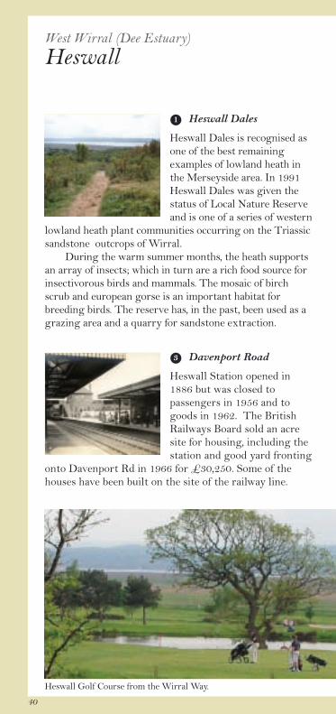
Heswall Dales
Heswall Dales is recognised asone of the best remainingexamples of lowland heath inthe Merseyside area. In 1991Heswall Dales was given thestatus of Local Nature Reserveand is one of a series of western
lowland heath plant communities occurring on the Triassicsandstone outcrops of Wirral. During the warm summer months, the heath supportsan array of insects; which in turn are a rich food source forinsectivorous birds and mammals. The mosaic of birchscrub and european gorse is an important habitat forbreeding birds. The reserve has, in the past, been used as agrazing area and a quarry for sandstone extraction.
1
Heswall Golf Course from the Wirral Way.

41
Heswall Golf Club
A distinguished and beautiful18 hole course. It has been thevenue for a number of nationalchampionships in recent years.The club has a very activeplaying membership and inrecent years, has hosted a
number of county, national and international fixtures.
4
Gayton
The Cottage Lane access leadsup to Gayton. After the golfclub entrance is Gayton FarmRoad that takes you pastGayton Windmill which wasbuilt in the 17th century and isprobably the oldest surviving
tower mill in Wirral. 100 years ago this area was calledLittle Gayton and at the end of the cobbled road is therear entrance to Gayton Hall. In 1330, ownership ofGayton passed to the Glegg family (Baskervyle Gleggfrom 1758). The Gayton Well (pictured) is nicknamed the Pin Well, as it was said that you would have your wish granted if you dropped a pin into it.
2
42
West Wirral (Dee Estuary)
Heswall
A540
25
24
22
cottage la
ne
boathouse lane
telegraph road
riverbank
rd
banks rd
park wes
t
backwood
lane
pipers
NCNRoute
56
Heswall Golf Club
access to beach
access to beach
HeswallDales
davenport road
bridge
stonebridge
stonebridge
Heswall
Gayton
1
3
2
4
23
Anti-clockwise
Clockwise
© Crown copyright and database rights 2011. Ordnance Survey 100019803.

43
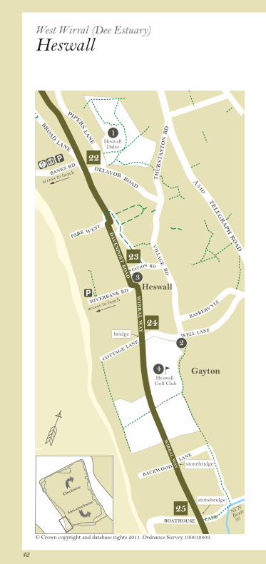
Anti-clockwise: Banks Road, Heswall - Boathouse Lane, Parkgate
At this location it is possible to access Heswall Dales viaBanks Rd, Delavor Rd and Pipers Lane.
Continue on until the trail joins Davenport Rd andcontinues along the road past Station Rd on the left. At theright bend rejoin the trail at the Wirral Way sign. Stay onthe Wirral Way, passing the small picnic area. Continue on,passing under the bridge and access points to Cottage Lane.
From Cottage Lane follow the Wirral Waytowards Neston, crossing the public footpath that goesright for the foreshore and left up into Gayton. Continueon under the stone bridges of Backwood Lane andBoathouse Lane from which there is limited pedestrianaccess. Continue along to the wooden bridge where it ispossible to turn right to go straight into Parkgate Parade.
Clockwise: Boathouse Lane, Parkgate - Banks Road, Heswall
Continue along the Wirral Way passing underthe stone bridges of Boathouse Lane and then BackwoodLane both of which have limited pedestrian access. As youcross Heswall Golf Club you will see the public footpaththat will take you left to the foreshore and right toGayton. The Wirral Way continues along to CottageLane, Gayton.
Having passed under the Cottage Lane bridgeand all its access points, continue along the trail to wherehere, the trail joins Riverbank Rd and into Davenport Rd.Passing Station Rd on the right, rejoin the trail at theWirral Way on the right at the point where the roadbends around to the left.
At this location it is possible to access Heswall Dales viaBanks Rd, Delavor Rd and Pipers Lane.
22
22
24 - 25
23 - 24
25 - 24
24 - 23