westminster reconnaissance report
TRANSCRIPT
WESTMINSTER RECONNAISSANCE REPORT
FREEDOM’S WAY LANDSCAPE INVENTORY
MASSACHUSETTS HERITAGE LANDSCAPE INVENTORY PROGRAM
Massachusetts Department of Conservation and Recreation
Freedom’s Way Heritage Association

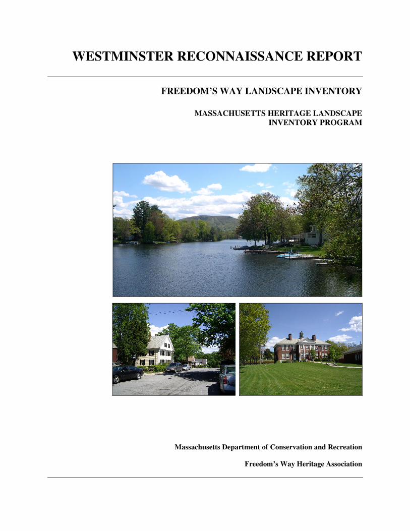
PROJECT TEAM Massachusetts Department of Conservation and Recreation Jessica Rowcroft, Preservation Planner Division of Planning and Engineering Freedom’s Way Heritage Association Mary Whitney, President Marge Darby, Chair, Advisory Committee Project Consultants Shary Page Berg Gretchen G. Schuler Local Project Coordinator Alicia Altieri Local Heritage Landscape Participants Alicia Altieri Marie Auger Donna Brownell Milly Chandler, FWHA Beth Donfro Lorraine Emerson Barbara Friedman Betsy Hannula Candi Hitchcock Tom O’Toole Jen Shenk Dan Stango Stephen Tremblay Mary Whitney, FHWA June 2006 Cover Photographs Wachusett Mountain from Wyman Pond Bacon Street Houses Upton School, Academy Hill Road
CONTENTS Introduction . . . . . . . . . . . . . . . . . . . . . . . . . . . . . . . . . . . . . . . . . . . . . . . . . . . . . 1 Westminster History . . . . . . . . . . . . . . . . . . . . . . . . . . . . . . . . . . . . . . . . . . . . . . 2 Priority Heritage Landscapes . . . . . . . . . . . . . . . . . . . . . . . . . . . . . . . . . . . . . . 3 Academy Hill – Westminster Village Cedar Swamp Cowee-Smith Site Savilampi Farm Schenck Farm The Narrows Van Hazinga Farm Critical Concerns. . . . . . . . . . . . . . . . . . . . . . . . . . . . . . . . . . . . . . . . . . . . . . . . 11 Agriculture – Farms and Fields Historic House Documentation Scenic Roads Protection Existing Resource Documentation and Planning Tools . . . . . . . . . . . . . . . . .13 Inventory of Historic and Archaeological Assets State and National Registers of Historic Places Planning Documents and Tools General Preservation Planning Recommendations . . . . . . .. . . . . . . . . . . . . 14 Inventory of Heritage Landscapes National Register Program Village and Rural Neighborhood Character Agricultural Landscape Scenic Roads Funding of Preservation Projects Conclusion . . . . . . . . . . . . . . . . . . . . . . . . . . . . . . . . . . . . . . . . . . . . . . . . . . . . . 19 Appendix: Heritage Landscapes Identified by Community . . . . . . . . . . . . . 21

Massachusetts Heritage Landscape Inventory Program 1 Westminster Reconnaissance Report
INTRODUCTION The Freedom’s Way Heritage Association includes 37 Massachusetts communities that are linked by historic events that helped to shape America’s democratic form of governance and the intellectual traditions that underpin American freedom, democracy, conservation and social justice. Freedom’s Way communities extend from Arlington on the east to Winchendon on the west. They represent a wide range of cities and towns, each shaped by the relationship between nature and culture. Heritage landscapes are special places created by human interaction with the natural environment that help define the character of a community and reflect its past. They are dynamic and evolving; they reflect the history of a community and provide a sense of place; they show the natural ecology that influenced land use patterns; and they often have scenic qualities. The wealth of landscapes is central to each community’s character, yet heritage landscapes are vulnerable and ever changing. For this reason it is important to take the first steps towards their preservation by identifying those landscapes that are particularly valued by the community – a favorite local farm, a distinctive neighborhood or mill village, a unique natural feature or an important river corridor. To this end, the Massachusetts Department of Conservation and Recreation (DCR) and the Freedom’s Way Heritage Association (FWHA) have collaborated to bring the Heritage Landscape Inventory program (HLI) to communities in the Freedom’s Way area. The primary goal of the program is to help communities identify a wide range of landscape resources, particularly those that are significant and unprotected. The focus is on landscapes that have not been identified in previous survey efforts in a given community. Another important goal of the program is to provide communities with strategies for preserving heritage landscapes. The methodology for the Heritage Landscape Inventory program was developed in a pilot project conducted in southeast Massachusetts and refined in Essex County. It is outlined in the DCR publication Reading the Land which has provided guidance for the program since its inception. In summary, each participating community appoints a Local Project Coordinator (LPC) to assist the DCR-FWHA consulting team. The LPC organizes a heritage landscape identification meeting at which interested residents and town officials offer community input by identifying heritage landscapes. This meeting is followed by a fieldwork session including the consulting team and the LPC, often accompanied by other community members. This group visits the priority landscapes identified in the meeting and gathers information about the community. The final product is this Reconnaissance Report, prepared for each participating community. It outlines the history of the community; describes the priority heritage landscapes; discusses planning issues identified by the community; identifies planning tools available in the community; and concludes with preservation recommendations. A list of all of the heritage landscapes identified by the community is included in the Appendix.
Massachusetts Heritage Landscape Inventory Program 2 Westminster Reconnaissance Report
WESTMINSTER HISTORY
Little is known about early Native American occupation of the territory that became Westminster; however based on activity in nearby areas it is likely that in the Woodland Period (3,000-450 B.P.1) Native Americans had some temporary campsites on Meetinghouse Pond, Wachusett Lake and probably other local ponds of which there are many. The Nashua, a subgroup of the Nipmucs, fished and hunted here before European settlement, which did not occur until 1728. This first settlement was known as Narragansett #2 with 60-acre lots given to descendants of King Philip’s War soldiers. At the time that the first meetinghouse was built here in 1739, there were only about 30 families but that expanded to 300 persons in 1759 when Westminster became a district. These early settlers laid out roads along Native trails including east-west routes in each part of town and roads radiating from Meetinghouse Hill (now Academy Hill). Westminster was incorporated as a town in 1770.
In this primarily agricultural community early farmers also built grist and saw mills due to numerous water ways and elevation changes making water power possible. Westminster was heavily forested so wood related industry took hold almost immediately. Colonial roads were upgraded in the early 19th century when Westminster’s thriving chair manufacturing businesses were established, as well as paper making and some textile mills, particularly at Wachusett Village.
In 1800 when the Fifth Massachusetts Turnpike passed through the middle of the town, the commercial center shifted away from the meetinghouse on top of the hill where the town common is today, down the hill to the current Westminster Village Center. Here in 1828 the Westminster Cracker Company got its start and expanded into its signature building in the village in 1842. In 1835 a road to Fitchburg was constructed and soon after in 1848 the Vermont & Massachusetts Railroad cut through Westminster. The population peaked at about this time with just under 2,000 people living in Westminster in 1850; however when the railroad passed through the northern part of town (bypassing the industrial areas) many of the mill factories shifted to Fitchburg and the chair factories to Gardner after they were no longer profitable in Westminster. Other mill buildings burned or were re-located closer to the railroad.
Some chair and paper manufactories remained into the 20th century. Immigrant workers were few until the early 20th century when many Finnish families came and took up farming. Those who had come before – Irish, Canadians and English – joined local workers in commuting to Fitchburg and Gardner mills via streetcar at the turn of the 20th century. In the 1920s the Mohawk Trail followed Westminster roads, eventually becoming Rt. 2. Other numbered routes were established in the 1930s: Worcester Road (Rt. 140); Ashburnham State Road (Rt. 12); and Fitchburg Road (Rt. 31).
The population decreased from its peak in 1850 so that there were only about 1,500 residents in 1915. In the 20th century the industry throughout Westminster declined. Yet despite this decline (with the exception of the Westminster
1 Before Present (B.P.) refers to before 1950.
Massachusetts Heritage Landscape Inventory Program 3 Westminster Reconnaissance Report
Cracker Company which continued to 1970), the population began to increase. During this time, houses were constructed along the existing roadways in town and lakeside cottages were built on the shores of lakes and ponds such as Wyman Pond and Partridge Pond. Many of the summer cottages along these waterbodies were later converted to year-round housing units. The population soared to over 5,000 in 1980. This rate of change continues so that now there are approximately 7,600 people living in Westminster. PRIORITY HERITAGE LANDSCAPES Westminster's Heritage Landscape Identification meeting, attended by about a dozen residents, some representing town boards and local non-profit organizations, was held on May 17, 2006. During the meeting residents compiled a lengthy list of the town's heritage landscapes, which is included in the Appendix. Once the comprehensive list was created, attendees were asked to articulate the value of each landscape and the issues relating to its preservation. Based on the information gathered, community members identified a group of priority landscapes to be visited by the consulting team during the fieldwork. Each of the priority landscapes is highly valued, contributes to community character and is not permanently protected or preserved. These landscapes, which are listed alphabetically, represent a range of scales and types of resources from individual farms to the village center. Several of the priority landscapes describe areas that have a number of layers of heritage landscapes appearing in the chart in the Appendix. Such layering shows the complexity and interdependence that are characteristic of most heritage landscapes. The descriptions and recommendations included here are an initial step in identifying resources valued by the community and suggesting action strategies. Academy Hill – Westminster Village Academy Hill rises from Main Street/South Street/Bacon Street and is the site of the first town center at the top of the hill with the meetinghouse site, town pound and some early dwellings arranged around the Town Common. Westminster Village at the bottom of Academy Hill is the present linear town center along East and West Main Street and Bacon Street where the 1839 Town Hall is located. In between these two areas are the 1912 Upton School (now vacant) and the modern Westminster Elementary School adjacent to it. The two areas and the link (Academy Hill Road) are listed in the National Register as one district; the Westminster Village – Academy Hill Historic District. Many historic dwellings, ranging from the 1793 Silas Beaman House – Emerson Tavern to the ca. 1890 Merriam House tell of the development of Westminster’s center along with the 1822 Universalist Church (later the American Legion), the 1865 Baptist Church, the Town Hall, the 1901 Classical Revival Forbush Memorial Library and many markers recalling the local history. One of Westminster’s most significant industrial structures is a feature of the village –

Massachusetts Heritage Landscape Inventory Program 4 Westminster Reconnaissance Report
the Westminster Cracker Company, which has recently been rehabilitated with close attention to its historic and architectural integrity. These two areas consolidate the civic history of Westminster; however the planning issues are slightly different. Academy Hill retains high integrity and has seemingly few vulnerabilities. It has a magnificent vista of Wachusett Mountain from the 1815 Rev. Cyrus Mann House and a quiet setting around the Town Common with no traffic issues. (This is the view on the town seal.)
Westminster Village, on the other hand, is on a main route that is heavily traveled, with building reuse and rehabilitation concerns and related parking issues. Several municipal properties are in transition including the Upton School, the Town Hall and the American Legion Hall (the old Universalist Church building). Presently there is a Request for Proposals (RFP) for reuse of the Town Hall.

Massachusetts Heritage Landscape Inventory Program 5 Westminster Reconnaissance Report
Recommendations The Westminster Master Plan already made recommendations of local historic district designation. The Historical Commission is the appropriate agency to begin the local historic districting process by requesting that the Selectmen appoint a study committee. Other issues of building reuse and rehabilitation may take cooperative efforts with the Selectmen and Planning Board which can be assisted by the Historical Commission in reviewing proposals that are consistent with preservation concerns. Refer also to Village and Rural Neighborhood Character in the General Preservation Planning Recommendations section of this report for information about the first two recommendations below. � Appoint study committee to develop a local historic district study report for
Academy Hill. The Selectmen are the appointing authority. � Consider a neighborhood architectural conservation district for Westminster
Village. � Work with Selectmen and Planning Board to include historic preservation
criteria when reviewing Town Hall RFPs. Reuse of this building requires flexible zoning and creative planning. Parking is a significant issue.
� Develop preservation standards for other key properties that may be
rehabilitated such as the Upton School. Such standards should be incorporated into RFPs. Senior housing is a use that has been highly successful in school buildings in other cities and towns.
Cedar Swamp Located south of Partridge Pond with frontage on Minott Road is a cedar swamp, which is within two privately owned parcels. The Cedar Swamp is a highly sensitive wildlife and ecological habitat, and provides scenic views. Protection of these two large parcels would connect other adjacent parcels of Westminster State Forest, which is owned by the Department of Conservation and Recreation. Westminster State Forest comprises three parcels of land; one large parcel immediately adjacent to Cedar Swamp with some frontage on Partridge Pond; one parcel south of Minott Road opposite the Cedar Swamp privately owned parcels; and one small parcel that is land locked. Current access to the DCR land is minimal. Recommendations The work of protecting the Cedar Swamp is best orchestrated by the Conservation Commission. The land owners no doubt are aware of the sensitive nature of the properties. Westminster has a local wetlands bylaw which has a 25’ ‘no disturb’ area within the 100’ wetlands buffer. In addition, Westminster has a zoning bylaw that does not allow wetlands or buffer zones to be used to meet minimum lot size requirements. Cedar Swamp has been identified by the Open Space Committee as an acquisition priority.

Massachusetts Heritage Landscape Inventory Program 6 Westminster Reconnaissance Report
� Begin discussion of potential conservation options with landowners and DCR’s Land Protection program, including conservation restrictions or DCR acquisition.
� Partner with local land trusts to raise funds for town or non-profit acquisition. Cowee-Smith Site
The Cowee-Smith Site is located within the Westminster Business Park, in the area named for its historic owner, James Cowee who had slaves working his farm in the 18th century. It is a documented historic archaeological site that was the subject of an intensive archaeological survey in 1993. Historic features and archaeological deposits associated with two historic farmsteads dating from the mid 18th through the 20th centuries were found here. The Cowee-Smith complex was occupied ca. 1742-1750 by Westminster's first minister, the Rev. Elisha Marsh; later by James Cowee (or Cohee), a slaveholder (ca. 1750-?); and then continuously occupied by his descendants at least up to the mid-19th century. The significance of the Cowee-Smith complex derives from the historical information that the site can provide about agricultural technology and production, economy, technology, and consumer choices in northern Worcester County, and the role of African-American slaves in this same area. The MHC has determined that the Cowee-Smith complex meets the National Register of Historic Places Eligibility Criterion A on the local level of significance and Criterion D on the local and state levels of significance. Residents attending the heritage landscape meeting expressed concern that this site may be developed, losing critical information about Westminster’s past. Recommendations Due to the sensitivity of the site and the good condition of its features, efforts should be made to avoid the Cowee-Smith complex, including roadways, stone fences and retaining walls near the site, during any construction or ground disturbing activities. The Historical Commission may assist in facilitating preservation efforts. � Work with property owner to encourage the granting of a site preservation
restriction to the Massachusetts Historical Commission to assure preservation of the complex.
� Conduct a site examination level survey of the complex to answer research
questions, delineate site boundaries and activity areas, and determine chronological sequences of construction and land use.
� Conduct further historical research of the complex including a search of the
land title, examination of probate and tax records of former residents, literature research on Massachusetts slavery, and railroad and industrial concerns at nearby Crocker Pond.

Massachusetts Heritage Landscape Inventory Program 7 Westminster Reconnaissance Report
� Establish an archaeological review committee (such as has been done in Medfield) that has the authority to review development proposals that may impact potential or documented archaeological sites. Contact the archaeology staff of the Massachusetts Historical Commission for guidance in possible approaches.
Savilampi Farm This old farm on the south side of South Ashburnham Road is near the southeastern edge of Crocker Pond and opposite a modern subdivision. The 33-acre property, once a farm, is no longer active. The farmhouse and farm buildings are set back from the road at the end of an unpaved lane. The rambling farmhouse with ells is at the center of several farm buildings including a couple of vertical board sheds and a long low barn. Meadows surround this farmstead. The lack of farming here makes this property vulnerable to change. Its location on a main road with substantial frontage increases the chances for development. It is one of three large farms in the northern part of Westminster, all of which are inactive and potential development sites. The land provides a scenic view from South Ashburnham Road and a reminder of Westminster’s agricultural past.
Recommendations Documentation is the first important step followed by working with the property owner to consider whether preservation strategies should be pursued. The Historical Commission is responsible for documentation and all town land use boards and commissions may assist in working to find solutions. � Document the farm on an MHC Area Form accounting for structures and
agricultural landscape including their historic uses. Include history of farm and description of farming activities as well as historic resources seen from the public way.
� Assemble an informal group to formulate a plan for preservation should the
Savilampi land become available.

Massachusetts Heritage Landscape Inventory Program 8 Westminster Reconnaissance Report
� Consider purchase options, preservation and conservation restrictions. Planning Board, Historical Commission and local non-profits should set priorities and consult with owner to determine appropriate preservation strategies.
� If development is inevitable explore ways to do partial development using
the Cluster Development Bylaw or a limited development. Schenck Farm The Schenck Farm is at the end of Howard Road, a dirt road that is lined with stone walls and old trees. Howard Road once extended through to Town Farm Road, but has been discontinued beyond the Schenck Farm adding to the farm’s remote location. The landscape is one of the most scenic in the area with rolling meadows, forested edges, views in all directions, an early 20th century gable front farmhouse up on a knoll close to the dirt road and a magnificent New England barn with picturesque cupola. The Midstate Trail passes along the edge of one of the meadows providing views of this lush agricultural landscape. This large 109-acre farm is in transition and there is no active farming presently. A number of partnerships are being forged to consider preservation strategies for the property. The North County Land Trust, whose mission it is to preserve the farms, forests and landscapes that define the character of the region, is the main organizer working with the North Quabbin Landscape Partnership and the Wachusett Working Landscape Partnership through the Mount Grace Land Conservation Trust. The town explored the possibility of an agricultural preservation restriction; however the land was not identified as having prime agricultural soils, therefore it did not qualify for an APR.

Massachusetts Heritage Landscape Inventory Program 9 Westminster Reconnaissance Report
Recommendations Documentation of the Schenck Farm will provide historical evidence of the property’s significance that will illuminate arguments in favor of preservation. The Historical Commission is responsible for recording the historical and architectural significance of historic properties. In addition the Historical Commission may contribute to the Planning Board’s potential efforts on behalf of the town working towards preservation of such a property. � Document the farm on an MHC Area Form accounting for structures and
agricultural landscape including their historic uses. � Encourage town and land trusts to stay engaged in pursuing preservation
strategies such as those recommended under Agricultural Landscapes in the General Preservation Planning Recommendations section of this report.
The Narrows Also known as Wachusett Village, this industrial area, southeast of Westminster Village, developed in the early 19th century with paper mills. Mill buildings lined Wyman Brook downstream from the Wyman Pond. Most were removed when the businesses moved to Fitchburg and Gardner to be near railroad depots. At about the same time that industry in Wachusett Village ceased, the Wachusett Reservoir was built to supply water to Fitchburg. Now the Narrows includes Wyman Pond, the granite water works building and the dam at Narrows and East Roads, extant early houses in the immediate area and some mill remnants off Narrows Road on Wyman Brook. A hiking trail crosses the brook passing some of the mill ruins. It is accessed by a narrow walking path near the intersection of Narrows and Stone Hill Roads. The town was gifted a 3.75 acre parcel of land abutting Wyman Brook at the May 2006 Annual Town Meeting.
Massachusetts Heritage Landscape Inventory Program 10 Westminster Reconnaissance Report
Recommendations Many of the houses on Narrows Road and East Road at Wachusett Village have been documented on MHC inventory forms, but none of the non-traditional resources has, such as the pond, the dam, granite structure and mill remnants. The Historical Commission is the appropriate agency to add to the historic assets inventory. For more information, refer to Inventory of Heritage Landscapes and Village and Rural Neighborhood Character in the General Preservation Planning Recommendations section of this report. � Compile a list of significant resources in The Narrows area that have not
been documented. Document these resources on MHC forms. Engage a professional archaeologist to document mill ruins and other archaeological resources in the area.
� Canvas area to determine opportunity for a local historic district or
neighborhood architectural conservation district.
� Work with property owners to preserve mill remnants. Consider preservation restrictions in accordance with M.G.L. Chapter 184, Sections 31-33.
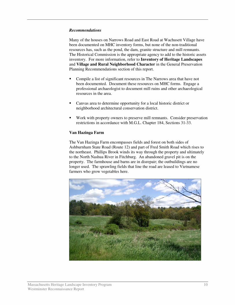
Van Hazinga Farm The Van Hazinga Farm encompasses fields and forest on both sides of Ashburnham State Road (Route 12) and part of Fred Smith Road which rises to the northeast. Phillips Brook winds its way through the property and ultimately to the North Nashua River in Fitchburg. An abandoned gravel pit is on the property. The farmhouse and barns are in disrepair; the outbuildings are no longer used. The sprawling fields that line the road are leased to Vietnamese farmers who grow vegetables here.

Massachusetts Heritage Landscape Inventory Program 11 Westminster Reconnaissance Report
Although a definitive subdivision plan has not yet been filed, there have been discussions about a planned development using the Cluster Development Bylaw. The proposed development area would be at the old gravel pit and the open space would be on the hill. A comprehensive permit application (40B affordable housing) for the land within the gravel pit has been submitted. The part of the fields through which Phillips Brook flows should be free of development due to wetlands and required river off-set of development. The scenic quality of this area from the road is worthy of preservation. According to the current homeowner, the farmhouse and surrounding land are under agreement. Recommendations Documentation of the Van Hazinga Farm will provide historical evidence of the property’s significance that may be used in setting preservation priorities. The Historical Commission is responsible for such documentation. In addition the Commission may identify features that should be preserved in the event that the Planning Board considers development proposals for this farm. � Document the farm on an MHC Area Form accounting for structures and
agricultural landscape, including the historic uses. � Work with property owner to preserve important features and reuse any
historic structures. CRITICAL CONCERNS In addition to the priority landscapes listed in the previous section, residents also identified critical concerns related to heritage landscapes and community character. These are town-wide issues that are linked to a range or category of heritage landscapes, not to a particular place. They are listed in alphabetical order. Community members also expressed interest in learning about preservation tools and strategies that have been effective in other Massachusetts communities and in identifying sources for preservation funding.
Agriculture – Farms and Fields
Once Westminster was a community of farms spread over the town; now only a few remain, most no longer active, except for some haying and a couple of horse farms. Farm buildings are abandoned and even some farmhouses appear to be vacated. Farming was a way of life that has been so vital to Westminster’s economy and its social structure; its loss is of concern to many who attended the heritage landscape identification meeting. Presently there are several farms that are in flux. It will not be possible for a community the size of Westminster to preserve them all; therefore it is imperative that the existing Open Space Committee continue its work in establishing priorities and setting goals. Preservation of farms has been a priority for the committee. It is this committee that can assist in developing terms when compromise is necessary to preserve part of a property that retains heritage landscape features while concentrating
Massachusetts Heritage Landscape Inventory Program 12 Westminster Reconnaissance Report
development on another part of the property. For more information on cluster development and flexible zoning refer to Agricultural Landscapes in the General Preservation Planning Recommendations section of this report.
Historic House Documentation Meeting attendees expressed concern about the level of historic house
documentation and particular concern for properties that have not been recorded such as the houses from the recent past. Documentation is recommended for all historic resources and heritage landscapes, using the MHC survey methodology. This information is useful to planners, educators and historical society curators and generally of enormous interest to local residents. Many of a community’s historic properties are vulnerable; therefore it is important that documentation occur before these threats are realized.
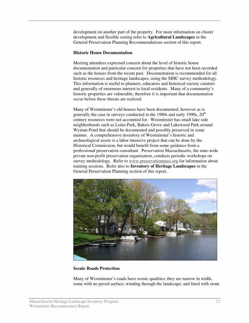
Many of Westminster’s old houses have been documented; however as is generally the case in surveys conducted in the 1980s and early 1990s, 20th century resources were not accounted for. Westminster has small lake side neighborhoods such as Leino Park, Bakers Grove and Lakewood Park around Wyman Pond that should be documented and possibly preserved in some manner. A comprehensive inventory of Westminster’s historic and archaeological assets is a labor intensive project that can be done by the Historical Commission, but would benefit from some guidance from a professional preservation consultant. Preservation Massachusetts, the state-wide private non-profit preservation organization, conducts periodic workshops on survey methodology. Refer to www.preservationmass.org for information about training sessions. Refer also to Inventory of Heritage Landscapes in the General Preservation Planning section of this report.
Scenic Roads Protection Many of Westminster’s roads have scenic qualities; they are narrow in width,
some with no paved surface; winding through the landscape; and lined with stone

Massachusetts Heritage Landscape Inventory Program 13 Westminster Reconnaissance Report
walls and many old trees. In addition vistas of agricultural landscapes with fields, farmhouses and barns are found along many of the roads in the northern part of town; roads throughout Westminster have wooded edges reflecting the large percentage of land that is forested. Westminster’s Master Plan recommended adoption of the Scenic Roads Act (M.G.L Chapter 40-15C) and designation of several roads in the bylaw. These roads were listed in two groups; Bean Porridge, Bragg, Davis and West Princeton Roads, followed by Barrel, Frog Hollow, Notown and Stone Hill Roads. However it would seem more efficient to adopt a bylaw and name all roads that qualify after developing criteria. Refer to Scenic Roads in the General Preservation Planning Recommendations section of this report.
EXISTING RESOURCE DOCUMENTATION AND PLANNING TOOLS Westminster already has important planning tools in place to document current conditions within the town; identify issues of concern to town residents; and develop strategies for action. This section of the Reconnaissance Report identifies some of the existing planning documents and tools that provide information relevant to the Heritage Landscape Inventory program. Inventory of Historic and Archaeological Assets The Massachusetts Historical Commission’s (MHC) Inventory of Historic and Archaeological Assets is a statewide list that identifies significant historic resources throughout the Commonwealth. In order to be included in the inventory, a property must be documented on an MHC inventory form, which is then entered into the MHC database. This searchable database, known as MACRIS, is now available online at http://www.sec.state.ma.us/mhc. According to the MHC, Westminster’s inventory documents about 200 historic resources ranging from the second quarter of the 18th century to the mid 20th century. Much of the work was completed in the 1980s. Westminster has two recorded ancient Native American sites dating back to the Woodland Period (3,000 – 450 B.P.) and 18 recorded historic archaeological sites. Due to the known information about other towns in the region as well as the apparent Native American activity in Westminster, it is assumed that there are significantly more archaeology sites. State and National Registers of Historic Places The National Register of Historic Places is the official federal list of districts, sites, buildings, structures and objects that have been determined significant in American history, architecture, archaeology, engineering and culture. The Town of Westminster’s National Register (NR) program began in 1983 when the Westminster Village – Academy Hill Historic District was listed with about 70 resources. This was followed by three individual listings – all dwellings that had been owned by various generations of the Wood family (the Abijah Wood House and Nathan Wood House, both on Worcester Road, and the Ezra Wood House on

Massachusetts Heritage Landscape Inventory Program 14 Westminster Reconnaissance Report
Depot and State Road East). All are automatically listed in the State Register of Historic Places. Westminster has no local historic districts, which would be listed in the State Register. It also has no preservation restrictions, which also would be listed in the State Register if drawn up in accordance with MGL Chapter 184, Sections 31-33. A preservation restriction (PR) runs with the deed and is one of the strongest preservation strategies available. Planning Documents and Tools
Planning documents for Westminster include the Westminster Master Plan of 2000, the Open Space and Recreation Plan, 1999-2004 and the Community Development Plan of 2004. In 1998 the Westminster Historic Preservation Plan was prepared by the Westminster Historical Commission. All of these plans point out an interesting fact when considering land use: forest land accounts for 70% of the total town acreage, which is 16,657 acres.
The Master Plan’s recommendations regarding heritage landscapes reiterate those in the Preservation Plan and include designation of a local historic district at Academy Hill as a priority followed by an expansion of that local historic district to include the rest of the NR district. This same plan also recommended adoption of a scenic roads bylaw and lists the priority roads to be Bean Porridge, Bragg, Davis and West Princeton Roads, followed by Barrel, Frog Hollow, Notown and Stone Hill Roads. Westminster has a Cluster Development Bylaw, which can be used to develop parcels that are 20+ acres in size. The minimum lot requirements are 15,000 square feet of area per lot and 50 feet of frontage. When using these minimum lot dimensions, part of the land is automatically reserved as open space. GENERAL PRESERVATION PLANNING RECOMMENDATIONS Recommendations pertaining to priority heritage landscapes can be found beginning on page 3. This section of the Reconnaissance Report offers more general recommendations relevant to preserving the character of the community that would be applicable to a wide range of community resources. Westminster’s residents place high value on the community's strong sense of place, which is created by its varied natural features and land use patterns that made use of the fertile land. The town has already taken measures to document and evaluate its most significant buildings and natural areas. It is now looking beyond the traditional resources to the landscapes, streetscapes, rural roads, neighborhoods and other natural and cultural assets that define the overall fabric of the community. Like most municipalities, Westminster is facing multiple pressures for change that threaten land-based uses and natural resources. Special places within the community that were once taken for granted are now more vulnerable than ever to change.
Massachusetts Heritage Landscape Inventory Program 15 Westminster Reconnaissance Report
Preservation planning is a three-step process: identification, evaluation and protection. Four useful documents to consult before beginning to implement preservation strategies are: � Department of Conservation and Recreation, Reading the Land
� Freedom’s Way Heritage Association, Feasibility Study
� Massachusetts Historical Commission, Survey Manual
� Massachusetts Historical Commission, Preservation through Bylaws and
Ordinances Recommendations that apply to a broad range of resources are discussed below. These recommendations are listed in the order in which they are most logically addressed when applying the three-step preservation planning process as described above. Thus the goal will be to (1) identify, (2) evaluate, (3) protect. Inventory of Heritage Landscapes The vital first step in developing preservation strategies for heritage landscapes is to record information about the resources on MHC inventory forms. One cannot advocate for something unless one knows precisely what it is – the physical characteristics and the historical development. The resources discussed in this Reconnaissance Report that have not been documented should be included in the next inventory project. Thus, using the Massachusetts Historical Commission survey methodology: � Compile a list of resources that are under-represented or not sufficiently
documented, beginning with heritage landscapes. � Document unprotected resources first, beginning with the most threatened
resources. � Make sure to document secondary features on rural, agricultural and
residential properties, such as outbuildings, stone walls and landscape elements.
� Record a wide range of historic resources including landscape features and
industrial resources.
� Conduct a community-wide archaeological reconnaissance survey to identify patterns of ancient Native American and historic occupation and to identify known and probable locations of archaeological resources associated with these patterns. Known and potential ancient Native American and historic archaeological sites should be documented in the field for evidence of their cultural association and/or integrity. All survey work should be completed by a professional archaeologist who meets the professional qualifications (950 CMR 70.01) outlined in the State Archaeologist Permit Regulations

Massachusetts Heritage Landscape Inventory Program 16 Westminster Reconnaissance Report
(950 CMR 70.00). The Inventory of Archaeological Assets of the Commonwealth contains sensitive information about archaeological sites. The inventory is confidential; it is not a public record (G.L. c. 9, ss. 26A (1)). Care should be taken to keep archaeological site information in a secure location with restricted access. Refer to the MHC article "Community-Wide Archaeological Surveys" which appeared in the Preservation Advocate, Fall 2005 which can be found at the following MHC link: http://www.sec.state.ma.us/mhc/mhcpdf/pafall05.pdf.
National Register Program Survey work will require an evaluation as to whether resources meet the qualifications for National Register listing. Using the information generated in the survey work and the accompanying National Register evaluations, expand Westminster’s National Register program. � Develop a National Register listing plan, taking into consideration a
property’s integrity and vulnerability. Properties that are in need of recognition in order to advance preservation strategies should be given priority.
� Consider potential district National Register nomination for Wachusett
Village (the Narrows) and other individual property nominations. Village and Rural Neighborhood Character Nearly all preservation strategies address village and neighborhood character in some manner. As described above, thorough documentation on MHC inventory forms is an important first step in the preservation planning process, followed by National Register listing where appropriate. Three traditional preservation strategies that may be appropriate for Westminster to consider are: a demolition delay bylaw; a local historic district bylaw (in accordance with M.G.L. Chapter 40C) and designation; and a neighborhood architectural conservation district bylaw and designation. � Demolition delay bylaws provide a time period in which towns can consider
alternatives to demolition. The Westminster Historical Commission should work with MHC staff to develop a bylaw that would best suit Westminster’s needs and should work with other town groups to publicize the advantages of a demolition delay bylaw to the community. Many demolition delay bylaws apply to structures that were built more than 50 years ago. The most common delay of demolition is six months; however many communities are finding that a one-year delay is more effective. A demolition delay bylaw requires a majority vote of Town Meeting.
� Local historic districts, adopted through a local initiative, recognize special
areas within a community where the distinctive characteristics of buildings and places are preserved and protected by the designation. These districts are the strongest form of protection for the preservation of historic resources.
Massachusetts Heritage Landscape Inventory Program 17 Westminster Reconnaissance Report
They are adopted by a 2/3 vote of the Town Meeting and administered by a district commission appointed by the Board of Selectmen. The MHC staff can assist the Westminster Historic District Study Committee appointed by the Selectmen in developing the necessary study report to determine appropriate local historic district designation for Academy Hill and the Village.
� Neighborhood architectural conservation districts also are local initiatives
that recognize special areas within a community where the distinctive characteristics of buildings and places are preserved and protected. They are less restrictive than local historic districts but still embrace neighborhood character. Neighborhood architectural conservation district designation is appropriate for residential neighborhoods that may have less integrity and where more flexibility is needed.
Agricultural Landscapes Preservation of agricultural landscapes means preservation of the farming activities, particularly in Westminster where farms are declining and their character is integral to the community’s past. It is important to know what the features of these agricultural landscapes are and which features the community treasures in order to make a case for preservation of these farms. Some preservation tools are available that can assist communities in preserving the actual farming activities even if only a few farms remain. Others are tools to preserve the landscape when the farm is sold. Westminster already has adopted the Cluster Development Bylaw which requires open space in a subdivision under this cluster bylaw. The town may want to consider other strategies that support farming activities. � Document additional farms that may not presently be included in
Westminster’s inventory of historic resource, using MHC survey forms. � Establish an agricultural commission to advocate for farming. � Adopt a right-to-farm bylaw which allows farmers to carry on farming
activities that may be considered a nuisance to neighbors. � Develop partnerships to raise funds to purchase development rights on farms
or to assist farmers in the restoration of historic farm buildings for which the owner would be required to donate a preservation restriction (PR).
� Continue public-private partnerships to preserve farm land through purchase
of conservation restrictions (CRs) or agricultural preservation restrictions (APRs).
Scenic Roads Scenic roads are an integral part of the historic fabric of the community. They are highly valued by Westminster residents and visitors alike and were listed as a

Massachusetts Heritage Landscape Inventory Program 18 Westminster Reconnaissance Report
critical issue. Roads must also accommodate modern transportation needs and decisions regarding roadways are often made with travel requirements as the only consideration. Westminster has not yet adopted the Scenic Roads Act (M.G.L. Chapter 40-15C). Once it does so the designated roads will require a review and approval for the removal of trees and stone walls that are within the right-of-way. Yet, in addition to roadway issues, much of what we value about scenic roads -- the stone walls, views across open fields -- is not within the public right-of-way. The preservation and protection of scenic roads therefore requires more than one approach. � Complete an inventory with descriptions and photo documentation of each of
the roads in Westminster including the character defining features that should be retained.
� Adopt a scenic roads bylaw; designate roads such as Bean Porridge, Bragg,
Davis and West Princeton Roads; and, add design criteria to be considered when approving removal of trees and stone walls, such as a provision allowing only one driveway cut per property on scenic roads. Coordinate procedures between Highway Department and Planning Board.
� Consider a scenic overlay district which may provide a no-disturb buffer on
private property bordering on scenic roads or adopt flexible zoning standards to protect certain views. Such bylaws could be written to apply to the numbered routes also, which would not be protected under a scenic roads bylaw.
� Develop policies and implementation standards for road maintenance and
reconstruction, including bridge reconstructions, which address the scenic and historic characteristics while also addressing safety. This is an important public process in which the community may have to accept responsibility for certain costs to implement standards that are not acceptable to projects funded by the Massachusetts Highway Department. Such standards should have a section addressing the way in which the local Highway Department maintains roads, for example requiring a public hearing if any additional pavement is to be added to a town road during reconstruction or repair. Policies can be adopted by local boards having jurisdiction over roads, or can be adopted at Town Meeting through a bylaw. In developing policies consider factors such as road width, clearing of shoulders, walking paths, posted speeds. A delicate balance is required.
Funding of Preservation Projects Funding for preservation projects is an important aspect of implementing preservation strategies. Both the MHC and DCR have had funding programs to assist communities in preservation related issues including: � Survey and Planning Grants, administered by the MHC, support survey,
National Register and preservation planning work.

Massachusetts Heritage Landscape Inventory Program 19 Westminster Reconnaissance Report
� The Massachusetts Preservation Projects Fund (MPPF), administered by the MHC, funds restoration and rehabilitation projects.
� The Historic Landscape Preservation Grant Program (HLPGP),
administered by DCR, funds planning, rehabilitation, education and stewardship projects focused on historic landscapes, including cemeteries.
Funding for state programs varies from year to year. When planning Westminster’s heritage landscape inventory program, contact relevant agencies to determine whether funding is available. Towns that have adopted the Community Preservation Act (CPA) find it to be an excellent funding source for many heritage landscape projects; however Westminster first would have to adopt the Act. While tricky to pass in lean economic times, the number and types of projects that are benefiting across the Commonwealth makes the CPA worthy of consideration. Westminster projects eligible for CPA funding would include MHC inventory, National Register nominations, cemetery preservation, open space acquisition and preservation and restoration of public buildings. The CPA (M.G.L. Chapter 44B) establishes a mechanism by which cities and towns can develop a fund dedicated to historic preservation, open space and affordable housing. Local funds are collected through a .5% to 3% surcharge on each annual real estate tax bill. At the state level the Commonwealth has established a dedicated fund that is used to match the municipality’s collections under the CPA. The amount of the surcharge is determined as a ballot question proposed at a town election. Adoption of the Community Preservation Act, by a majority vote on a ballot question, fosters partnerships among historic preservationists, conservationists and affordable housing advocates. At least 10% of the funds must be used to preserve historic resources; at least 10% must be used to protect open space; and at least 10% must be used to advance affordable housing. The remaining 70% must be used for one of these three uses as well as recreational needs and can be distributed in varying proportions depending upon the projects that the town believes are appropriate and beneficial to the municipality. Additional information about the CPA can be found at www.communitypreservation.org. CONCLUSION The Westminster Reconnaissance Report is a critical tool in starting to identify the rich and diverse heritage landscapes in Westminster and in beginning to think about preservation strategies. Westminster will have to determine the best way to implement the recommendations discussed above. One approach that might help Westminster begin the process is to form a Heritage Landscape Committee, as described in Reading the Land. Landscapes identified in this report, especially the priority landscapes, will typically need further documentation on MHC inventory forms. The documentation in turn can be used in publicity efforts to build consensus and

Massachusetts Heritage Landscape Inventory Program 20 Westminster Reconnaissance Report
gather public support for their preservation. Implementation of recommendations will require a concerted effort of and partnerships among municipal boards and agencies, local non-profit organizations, and state agencies and commissions. Distribution of this Reconnaissance Report to the municipal land use boards and commissions will assist in making this one of the planning documents that guides Westminster in preserving important features of the community’s character. The recommended tasks will require cooperation and coordination among boards and commissions, particularly Westminster's Historical Commission, Planning Board, the Conservation Commission and the Open Space Committee. It also is advisable to present this information to the Board of Selectmen, the applicants to the Heritage Landscape Inventory program on behalf of the town. Finally distribution of the report to the Historical Society, neighborhood associations, and any other preservation-minded organizations such as Mount Grace Land Conservation Trust and North Quabbin Landscape Partnership will broaden the audience and assist in gathering interest and support for Westminster's heritage landscapes.

Massachusetts Heritage Landscape Inventory Program 21 Westminster Reconnaissance Report
APPENDIX: HERITAGE LANDSCAPES IDENTIFIED BY COMMUNITY This list was generated by local participants at the Heritage Landscape Identification Meeting held in Westminster on May 17, 2006 and the follow-up fieldwork on May 24, 2006. There are undoubtedly other heritage landscapes that were not identified at the HLI meeting noted above. The chart has two columns, the names and locations of resources are in the first; notes about resources are in the second. Landscapes are grouped by land use category. Abbreviations used are listed below. APR = Agricultural Preservation Restriction CR = Conservation Restriction LHD = Local Historic District NR = National Register PR = Preservation Restriction * = Priority Landscape + = Part of a Priority Landscape
Agriculture
Farmers Cooperative Building Leominster St.
Set up by Finnish farmers in the area and built in 1929. Now owned by Conservation Commission, the building is protected and has a plaque telling history of the building.
Johnson Farm Minnot Rd.
An egg farm which is currently being used by The Country Hen.
October Farm 93 West Princeton Rd.
Wachusett Brewery started here. Historic house and large New England barn.
Savilampi Farm * South Ashburnham Rd.
Near Crocker Pond. No longer farmed. Includes farmhouse and farm buildings set back from the road.
Schenck Farm * 70 Howard Rd.
Rolling hayfields behind early 20th century house with attached barn. Working with the North County Land Trust, North Quabbin Landscape Partnership and Mount Grace Land Conservation Trust to preserve the agricultural fields.
Van Hazinga Farm* Ashburnham State Rd.
On Ashburnham State Road (Route 12) at Bean Porridge Hill Road and Fred Smith Road.
Archaeological
Cowee Hill Bean Porridge Hill Rd.
The site is located within the Woods at Westminster Golf Course.
Cowee-Smith Site *
The site is within Westminster Business Park. Was the farm of James Cowee who is documented to have held slaves. Site is documented.
Massachusetts Heritage Landscape Inventory Program 22 Westminster Reconnaissance Report
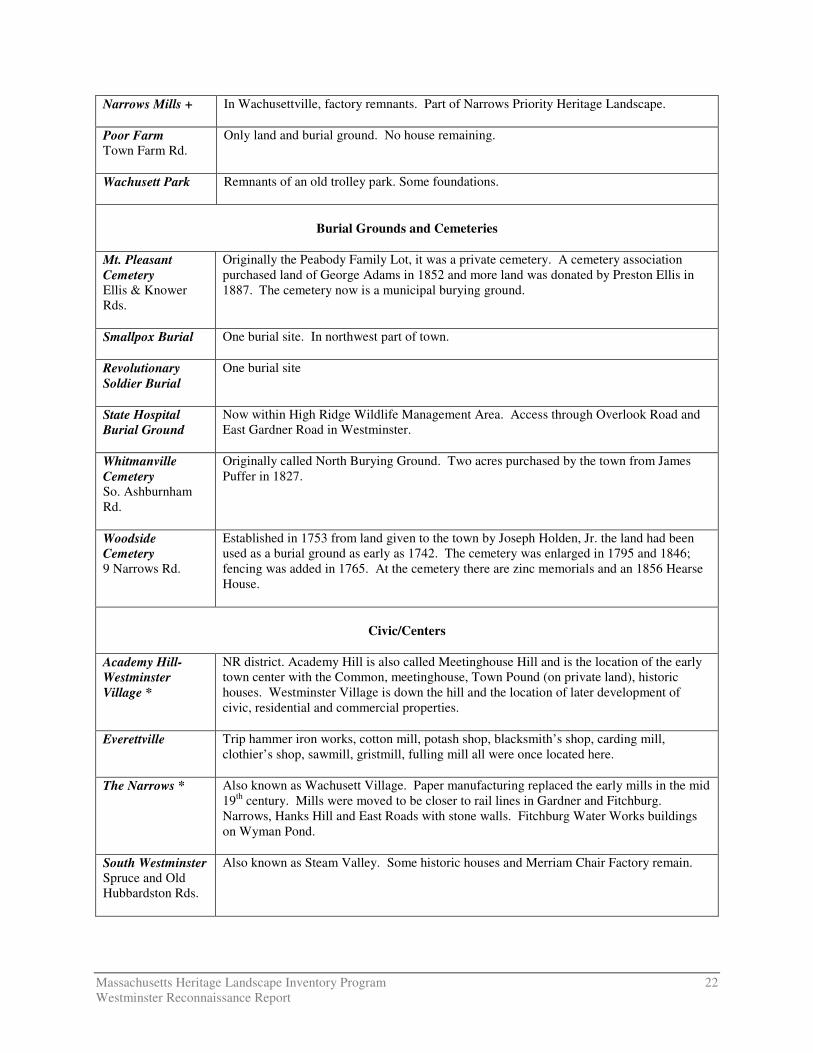
Narrows Mills +
In Wachusettville, factory remnants. Part of Narrows Priority Heritage Landscape.
Poor Farm Town Farm Rd.
Only land and burial ground. No house remaining.
Wachusett Park
Remnants of an old trolley park. Some foundations.
Burial Grounds and Cemeteries
Mt. Pleasant Cemetery Ellis & Knower Rds.
Originally the Peabody Family Lot, it was a private cemetery. A cemetery association purchased land of George Adams in 1852 and more land was donated by Preston Ellis in 1887. The cemetery now is a municipal burying ground.
Smallpox Burial One burial site. In northwest part of town.
Revolutionary Soldier Burial
One burial site
State Hospital Burial Ground
Now within High Ridge Wildlife Management Area. Access through Overlook Road and East Gardner Road in Westminster.
Whitmanville Cemetery So. Ashburnham Rd.
Originally called North Burying Ground. Two acres purchased by the town from James Puffer in 1827.
Woodside Cemetery 9 Narrows Rd.
Established in 1753 from land given to the town by Joseph Holden, Jr. the land had been used as a burial ground as early as 1742. The cemetery was enlarged in 1795 and 1846; fencing was added in 1765. At the cemetery there are zinc memorials and an 1856 Hearse House.
Civic/Centers
Academy Hill-Westminster Village *
NR district. Academy Hill is also called Meetinghouse Hill and is the location of the early town center with the Common, meetinghouse, Town Pound (on private land), historic houses. Westminster Village is down the hill and the location of later development of civic, residential and commercial properties.
Everettville
Trip hammer iron works, cotton mill, potash shop, blacksmith’s shop, carding mill, clothier’s shop, sawmill, gristmill, fulling mill all were once located here.
The Narrows * Also known as Wachusett Village. Paper manufacturing replaced the early mills in the mid 19th century. Mills were moved to be closer to rail lines in Gardner and Fitchburg. Narrows, Hanks Hill and East Roads with stone walls. Fitchburg Water Works buildings on Wyman Pond.
South Westminster Spruce and Old Hubbardston Rds.
Also known as Steam Valley. Some historic houses and Merriam Chair Factory remain.
Massachusetts Heritage Landscape Inventory Program 23 Westminster Reconnaissance Report
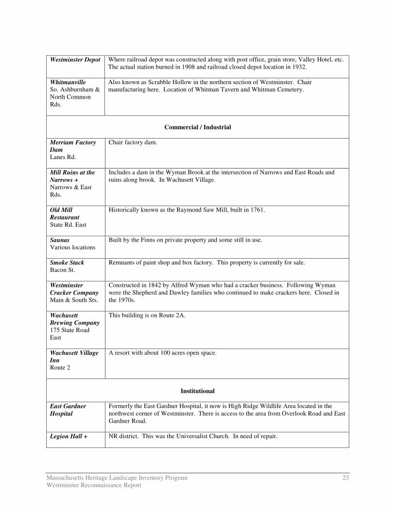
Westminster Depot
Where railroad depot was constructed along with post office, grain store, Valley Hotel, etc. The actual station burned in 1908 and railroad closed depot location in 1932.
Whitmanville So. Ashburnham & North Common Rds.
Also known as Scrabble Hollow in the northern section of Westminster. Chair manufacturing here. Location of Whitman Tavern and Whitman Cemetery.
Commercial / Industrial
Merriam Factory Dam Lanes Rd.
Chair factory dam.
Mill Ruins at the Narrows + Narrows & East Rds.
Includes a dam in the Wyman Brook at the intersection of Narrows and East Roads and ruins along brook. In Wachusett Village.
Old Mill Restaurant State Rd. East
Historically known as the Raymond Saw Mill, built in 1761.
Saunas Various locations
Built by the Finns on private property and some still in use.
Smoke Stack Bacon St.
Remnants of paint shop and box factory. This property is currently for sale.
Westminster Cracker Company Main & South Sts.
Constructed in 1842 by Alfred Wyman who had a cracker business. Following Wyman were the Shepherd and Dawley families who continued to make crackers here. Closed in the 1970s.
Wachusett Brewing Company 175 State Road East
This building is on Route 2A.
Wachusett Village Inn Route 2
A resort with about 100 acres open space.
Institutional
East Gardner Hospital
Formerly the East Gardner Hospital, it now is High Ridge Wildlife Area located in the northwest corner of Westminster. There is access to the area from Overlook Road and East Gardner Road.
Legion Hall + NR district. This was the Universalist Church. In need of repair.

Massachusetts Heritage Landscape Inventory Program 24 Westminster Reconnaissance Report
Town Hall + 5 Bacon St.
NR district. The Westminster Town Hall was constructed in 1839 in the Greek Revival style.
Upton School + Academy Hill Rd.
NR district. 1912 Colonial Revival school building that is currently unoccupied.
Miscellaneous
Monuments
This includes memorial markers and monuments found throughout town.
Spite Wall North Common Rd.
A wall that is about 10 feet high, built so that diagonally located neighbor did not have to view his neighbor farming his land on Sundays.
Natural
Balance Rock Wachusett Mountain
Two huge boulders – one on top of the other – that are glacial deposits on Wachusett Mountain.
Cedar Swamp *
Southern edge of Partridge Pond. Not visible from road.
Crow Hill Ledges
These ledges, thought to have been used by Native Americans, are located in Leominster State Park.
Muddy Pond
Undeveloped natural pond (not man-made), located in the northern part of town.
Tophet Swamp State Rd.
This is a large cedar swamp on both sides of State Road northwest of Academy Hill-Westminster Village. It is part of the Whitman River Water Basin.
Trees
There are many significant trees throughout town that should be protected.
Open Space /Parks
Hager Park Rt. 140
Both sides of Route 140. 18 acres on one side and more on the other. Mostly wooded.
Leominster State Forest 90 Fitchburg Rd.
Located in 5 towns (Princeton, Westminster, Sterling, Fitchburg and Leominster) the state forest comprises 4,300 acres. The Crow Hill ledges are within the forest and thought to have been used by Native Americans. Land grants near each of the above mentioned towns became known as Notown until they were annexed to each of the towns in 1838. Notown is within Leominster State Forest. The Midstate Trail passes through the Forest. A CCC camp was built here in 1933.
Midstate Trail This Field and Forest Club trail was constructed in 1927 linking Mt. Watatic with Wachusett Mountain and since the 1970s linking Rhode Island with New Hampshire. It meanders through Westminster from Princeton to Round Meadow Pond and north to Ashburnham. The Midstate Trail Committee, an affiliate of the Appalachian Mountain Club, maintains it.

Massachusetts Heritage Landscape Inventory Program 25 Westminster Reconnaissance Report
North Common Road Fields
Possibly a reference to fields on South Ashburnham Road which is the continuation of North Common Road.
The Rambler Area Has a pavilion built by the Boy Scouts.
Simplex Land Simplex Dr.
Off Overlook Road north of Route 2.
TRW Soccer Field Rt. 2A
Soccer field now on private corporation land was built by a club.
View of Wachusett Mountain
The summit of Wachusett Mountain is in Princeton; however it is an important part of Westminster’s landscape with many fine views from various prospects in town.
Westminster Country Club 51 Ellis Rd.
Golf course (18-holes) at semi-private club. Designed by Al LeBlanc and built in 1957.
Westminster State Forest Minott Rd.
Three separate parcels. Near the Cedar Swamp.
Woods at Westminster Golf Course 90 Bean Porridge Rd.
New 18-hole public golf course built on Cowee Hill which is one of many hills that defines Westminster’s topography.
Residential
Lawrence House 34 Carter Rd.
This ca. 1754 colonial house was first known as the Reuben Miles House and later as the Carter Place.
M House 70 Knower Rd.
Patrick Gately House is a ca. 1855 Gothic Revival house. (MHC listing WST.43 says Knowler Road which is incorrect spelling of road name.)
Miles Birthplace 104 Turnpike Rd.
Built in 1824, this Federal style house is known as the General Nelson Miles house.
Miles Boyhood Home 103 Turnpike Rd.
Also known as the Daniel Miles House, it was built in 1845 in the Greek Revival style across the street from the Miles Birthplace.
Miles, Daniel C. House + 116 Main St.
NR (part of district).
Miller House + 13 Leominster Rd.
NR (part of district). Built in 1890 for Frank A. Miller in the Greek Revival style.
Massachusetts Heritage Landscape Inventory Program 26 Westminster Reconnaissance Report
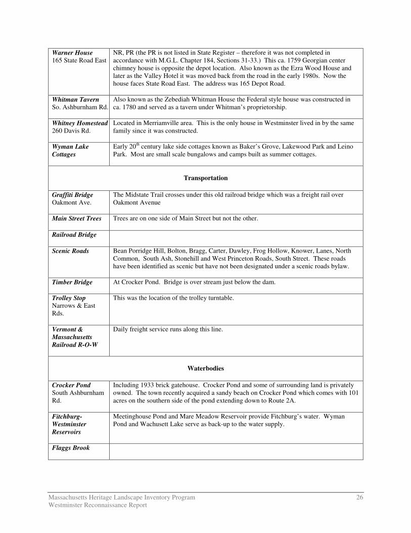
Warner House 165 State Road East
NR, PR (the PR is not listed in State Register – therefore it was not completed in accordance with M.G.L. Chapter 184, Sections 31-33.) This ca. 1759 Georgian center chimney house is opposite the depot location. Also known as the Ezra Wood House and later as the Valley Hotel it was moved back from the road in the early 1980s. Now the house faces State Road East. The address was 165 Depot Road.
Whitman Tavern So. Ashburnham Rd.
Also known as the Zebediah Whitman House the Federal style house was constructed in ca. 1780 and served as a tavern under Whitman’s proprietorship.
Whitney Homestead 260 Davis Rd.
Located in Merriamville area. This is the only house in Westminster lived in by the same family since it was constructed.
Wyman Lake Cottages
Early 20th century lake side cottages known as Baker’s Grove, Lakewood Park and Leino Park. Most are small scale bungalows and camps built as summer cottages.
Transportation
Graffiti Bridge Oakmont Ave.
The Midstate Trail crosses under this old railroad bridge which was a freight rail over Oakmont Avenue
Main Street Trees Trees are on one side of Main Street but not the other.
Railroad Bridge
Scenic Roads Bean Porridge Hill, Bolton, Bragg, Carter, Dawley, Frog Hollow, Knower, Lanes, North Common, South Ash, Stonehill and West Princeton Roads, South Street. These roads have been identified as scenic but have not been designated under a scenic roads bylaw.
Timber Bridge
At Crocker Pond. Bridge is over stream just below the dam.
Trolley Stop Narrows & East Rds.
This was the location of the trolley turntable.
Vermont & Massachusetts Railroad R-O-W
Daily freight service runs along this line.
Waterbodies
Crocker Pond South Ashburnham Rd.
Including 1933 brick gatehouse. Crocker Pond and some of surrounding land is privately owned. The town recently acquired a sandy beach on Crocker Pond which comes with 101 acres on the southern side of the pond extending down to Route 2A.
Fitchburg-Westminster Reservoirs
Meetinghouse Pond and Mare Meadow Reservoir provide Fitchburg’s water. Wyman Pond and Wachusett Lake serve as back-up to the water supply.
Flaggs Brook

Massachusetts Heritage Landscape Inventory Program 27 Westminster Reconnaissance Report
Mare Meadow Reservoir South St.
Public water supply. Part of the Ware River Watershed.
Meetinghouse Pond
Public water supply. Part of the Nashua River Watershed. Owned by Fitchburg and supplies about 60% of Westminster customers. Fitchburg owns over 1,500 acres on the shores of the Pond while Westminster owns 15+ acres as water supply protection. Undeveloped on the edges. Square brick pump house.
Millers River
Muddy Pond Undeveloped natural pond – Conservation land abuts pond
North Branch Nashua River
Headwaters in Westminster near Fitchburg border.
Phillips Brook Flows from its headwaters in Ashburnham south along Rt. 12 through Westminster to West Fitchburg where it joins the North Branch Nashua River. Trout brook.
Round Meadow Pond State Road East
Pond is adjacent to Route 2. Summer cottages built around pond in the mid 20th century.
Wachusett Lake Natural Great Pond – glacial lake.
Whitman River Flows from Gardner east through Westminster linking Whitman Reservoir and Crocker Pond before flowing into Fitchburg where it joins the North Branch Nashua River.
Wrights Reservoir Mostly in Gardner.
Wyman Brook Narrows Rd.

FRED SMITH ROAD
BARREL ROAD
BEAN
PORRIDGE H
ILL ROADEAST GARDNER ROAD
SIMPLEX DRIVE
ROUTE 2
ROUTE 2
STATE ROAD WEST
COLONY ROAD
SPRUCE STREETKNOWER ROAD
NEWTON ROAD
HARRINGTON ROAD
NOTOWN ROAD
STON
EHILL
ROAD
EAST
ROA
D
SOUTH S
TREET
WEST PRINCETON ROAD
1
1
2
3
4
5
6
7
G a r d n e rG a r d n e r
F i t c h b u r gF i t c h b u r g
P r i n c e t o nP r i n c e t o n
A s h b u r n h a mA s h b u r n h a m
H u b b a r d s t o nH u b b a r d s t o n
L e o m i n s t e rL e o m i n s t e r
S t e r l i n gS t e r l i n g
WESTMINSTEROPENSPACE & HISTORIC RESOURCES
1. Academy Hill - Westminster Village2. Cedar Swamp3. Cowee Farm and Hill4. Savolampi Farm5. Shenk Farm6. The Narrows7. Van Hazinga Farm
DCRDCRS/DFGDFGOther StateCounty
MunicipalFederalLand TrustNon-ProfitConservation Restriction
Agricultural Preservation RestrictionCR/APR CombinationOther Legal InterestState Historic Resources
InterstateState Local RoadRivers and StreamsLakes and Ponds
Note: Default Legend, all categories may not appear on the map.
¹0 0.5 1 Miles