wetland preservation
TRANSCRIPT


Salt marsh. The words are foreign to most Nebraskans- " and if theybring to mind any image at all, it is probably .-1 an image of thecoastline of Virginia or the Carolinas; of blue and fiddler crabs,oysters and screaming mobs of gulls and terns; perhaps it is animage of seemingly barren, land-locked waters: the Great Salt Lakein Utah or the Salton Sea in California. The mention of Nebraskasalt marshes brings only looks of puzzlement, but Nebraska has saltmarshes, and, al- though small by comparison, they have much incommon with those elsewhere on the continent.
All are born of saltwater and sustained by it. We recognize akinship through the plant names they share: cordgrass, alkali bulrush,saltwort, sea blite and widgeon grass. Nebraska's salt marshes aresmaller than the coastal salt marshes, and receive no twice-dailywash of ocean tides, but in a manner of speaking, their saline watersare the flow of an ancient inland sea.
If salt marshes in Nebraska seem unlikely, it is with good reason.Even before settlers laid claim to what would one day be Nebraska,salt marshes were few in number and small in extent, essentiallylimited to the floodplains of Salt Creek and its tributaries inLancaster and Saunders counties. Today, these unique salinewetlands, with their communities of salt-loving plants, are evenfewer in number. Those which remain are smaller and have sufferedmuch at the hand of man. They are Nebraska 's most rare and mostthreatened natural community, truly the last of the least.
A History EntwinedThe story of eastern Nebraska 's salt marshes is also the history of
Salt Creek and the city of Lincoln. Through geologic and humanhistory, their courses have been inextricably entwined. Salt Creekand its tributaries shaped the landscape and supplied the water, bothsaline and fresh, which created these unique wetlands in easternNebraska. At least in part, it was because of the saltwater basins thatLincoln was founded and became the state's capital.
Salt Creek traces the western and northern edges of Nebraska 'scapital city. Near Lincoln, Salt Creek today is a deep canal containedby levees. Its floodwaters no longer threaten the city, and itefficiently performs the uncomely task of carry- ing away thedischarge of Lincoln 's gutters and processed sewage. It bears onlyscant resemblance to a natural stream. it was not always so:
As we viewed the land upon which now stands this greatbusy city, we had the exciting pleasure of seeing for the firsttime a large drove of beautiful antelope, cantering across theprairie about where the government square is (9th and Ostreets]. We forded Salt Creek, just by the junction of OakCreek, and what a struggle we had in making our way throughthe tall sunflowers between the ford and the basin. There wassomething enchanting about the scene that met our eyes. Thefresh breeze sweeping over the salt basins reminded us of themorning breezes at the ocean beach.
W W Cox, 1888. Describing theLincoln landscape of July 1861.
Cox noted that "elk and antelope were plentiful," that Salt Creekand Oak Creek were "wonderfully supplied with fish," and said "thebasin was a great place for wild water fowls to congregate. Geese,brant, swan, ducks and pelicans were there
by the thousands, and it was the hunter's paradise."The basin Cox referred to was Salt Lake, west of shlt Creek about two
miles west of Lincoln, variously known over the years as Chester Basin,The Great Basin, Gregory Basin, Bur- lington Beach and, most recently,as Capitol Beach. Near this basin, numerous small tributaries joined SaltCreek, and game trails radiated out from it like spokes from a hub. WhileSalt Lake was the largest of the salt basins it was only one of many:
The Great Basin ...covers an area of about 400 acres. The brineissues from a large number of places all overthe surface, but in small quantities. All the salt water that comes to thesurface from this basin unites in one stream, and we estimate the entireamount of water that flowed from this basin at from six to eightgallons per minute. The second salt basin lies between Oak and Saltcreeks and covers an area of two hundred acres. The third basin

is on [lower] Little Salt Creek, called Kenosha Basin, and coverstwo hundred acres. Numerous small basins occur on MiddleCreek, which occupy in all about six hundred acres. BetweenMiddle and Salt creeks are several small basins, covering 40 or 50acres. From the surface of all these basins more or less spring oozeout.
Besides the numerous basins above mentioned, Salt Creek,Hayes's [probably Haines] Branch, Middle Creek, Oak and LittleSalt creeks have each a dozen springs coming out near the water'sedge. One spring on Salt Creek issues from a sand-rock [Dakotasandstone], and gushes forth with a stream as large as a man's arm,at the rate of four gallons a minute.
F.V Hayden. U.S. Geologist. FirstAnnual Report of the United States Geological
Survey of the Territories. Embracing Nebraska. 1867.
Moderately saline wetlands, such as those along Rock Creek, do not have complete communities of salt-tolerant plants.
Other accounts describe a less well-watered basin:Approaching Lincoln from the east, the first remark- able object that
meets the eye of the stranger is a succession of what appears to be severalbeautiful lakes extending along the lines of Salt Creek to the northwardand westward of the town, the nearest a mile distant. As their crystalsurfaces glisten like molten silver in the sunlight the illusion is complete,and the most critical landscape painter would be deceived as to theircharacter. But there is no water enclosed in their grassy banks, yet one isnot undeceived till he arrives upon their brink. These apparent lakes arethe Salt Basins of Lancaster County, in themselves natural curiosities wellworthy of a long journey to visit them. The floor of these basins is hardclay, smooth and level as a brick-yard and polished as that of a Hollander'skitchen. They are covered with a white layer of crystallized salt,

An 1888 Lincoln map shows existing and proposed divisions of the city, original stream courses and largerwetlands. Most wetlands have been filled and streams channelized. Stream courses and standing water today areshown in blue. Several principal streets and highways are indicated in red. Salt incrustations, opposite,form onseasonally dry wetlands as saline water evaporates.
NEBRASXA Copyright 1888
.y
, J'.P.WA..'rON.,
',\\

Wonderfully pure, and in more or less abundance according tothe length of time that has elapsed since the last rain.Intersecting these salt floors are little streams of salt water, sostrongly impregnated that it will almost abrade the tongue andlips when tasted. Upon the west side of Salt Creek the wholesurface of the soil for two or three miles around the basins iscovered with salt, but this peculiarity does not occur on the eastside.
Nebraska Commonwealth, Sept. 7, 1867.Because so little time passed between the first written descriptions
of the salt basins and the time when settlers began LO reshape them,it is not clear how often these wetlands held water or how muchwater they held. Accounts suggest the basins fluctuated betweenbeing "so flooded with water that it was impossible to define anyportion of them as saline lands," and being dry lake-beds with "floorsof compact earth, covered with a layer of saline crystals." Probablyboth descriptions are accurate, depending on when in the annual (orlong-term) cycle of precipitation the observer happened to see thebasins.
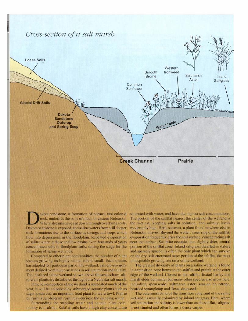
Salt of the EarthThe explanation of the origin of these salt marshes lies under the
region's mantle of fine loess soil and along the network of streamswhich have carved through it. Salt Creek has its source in thesouthwest corner of Lancaster County, 20 miles south- west ofLincoln. Salt Creek's two uppermost branches, Olive Branch andHickman Branch, join near Roca to form the main stream. South ofLincoln, Salt Creek is fed by several freshwater streams, buttributaries from the west and north carry saline waters. About 13miles northeast of Lincoln, below the mouth of Rock Creek (a mildlysaline tributary), more freshwater streams flow into Salt Creek beforeit releases its burden of water to the Platte River east of Ashland. SaltCreek is an anomaly among Nebraska streams in that it flowsprincipally to the northeast. About 52 miles long from headwater tomouth, Salt Creek drains an area of about 1,627 square miles.
The saline tributaries which gave Salt Creek its name share acommon characteristic: their waters originate from, or flow through,Dakota sandstone, the only underlying rock formation naturallyexposed in the region. For the most part, this porous, rust-colored,ferruginous sandstone is soft, crumbles under little pressure, andweathers quickly. The ultimate source of the saline waters, though,lies deeper, in ancient shales laid down in Cretaceous times, the Ageof Reptiles, some 70 to 160 million years ago, when much of centralNorth America was covered by a vast inland sea.
The first government survey of the region, in 1857, noted thepotential wealth to be harvested from eastern Nebraska's salt basins.Settlers, and Indians long before them, had gathered the salt fromnatural deposits for their own use or for barter. Commercialexploitation began in earnest in the late 1850s, and the "salt boom"continued well into the 1880s. During the early years, salt wassimply scraped from the surface, but soon commercial production bya variety of techniques began. Brine was pumped with windmills,concentrated in evaporation vats, and boiled in large kettles. By theearly 1860s, several commercial ventures were extracting the basins'wealth of salt.
So promising was the salt industry, at least to some individualsof considerable influence, that it was a significant factor in the
selection of the city of Lancaster as the site of the new territorial capitalwhen it was moved from Omaha. At the time, Lancaster, soon to berenamed Lincoln, claimed no more than 30 residents, most engaged ingathering salt. Designated the state's capital in 1867, optimism for thefuture of Lincoln soared. The Nebraska Commonwealth, a Lincolnnewspaper and strong supporter of the salt basin site, noted in Septemberof 1867 that "The development of the saline resources of the Basin wouldof itself, were there no other inducements, in- evitably attract the ironarms of commerce to Lancaster County, and with no other aid, a town ofgreat commercial importance is bound to be located on Salt Creek." For atime, there was noteworthy commercial production; in 1866, onecompany alone produced 125,000 pounds of salt for sale.
Much of the hope for the development of a salt processing industryhinged on tapping a supposed buried "mother lode" from which the saltybrine rose to the surface as seeps and springs. In October of 1869, a wellwas sunk for that purpose on the east bank of Oak Creek, about a mileabove its confluence with Salt Creek. At 600 feet, drillers "struck a strongartesian flow," but neither aquifers of concentrated brine nor rock saltdeposits were encountered. Subsequent wells were equally disappointing.In 1887, in an attempt to determine the validity of the purportedcommercial-value salt deposit, the state of Nebraska contracted for adeeper well, this one about two miles west of Lincoln on the south shoreof Salt Lake. Drillers encountered salt water at about 200 feet andflowing water at about 600 feet. When the work stopped at 2,463 feet,there was no indication ofa salt deposit, and the strongest brine camefrom a band of sand and gravel at about 200 feet. This revelation, coupledwith the development of easily mined salt deposits in Kansas, and thearrival of railroads bringing an unlimited supply of cheap salt, dashed allfurther hopes of a salt industry in Lincoln's salt basin. Lincoln's salinewaters were not totally without commercial value during the city's earlyyears, however. Popular in the late 1880s and early 1890s, were severalLincoln bath houses and sanitariums featuring sulphosaline waterspurported to possess all varieties of curative powers.
Lincoln would never be the region's salt production center, but it wasentrenched as the state's capital, and, in the eyes of many, it was situated ina most undesirable location:

While this one-time famous salt basin yielded no importantbenefits to mankind, it unfortunately in- fluenced thecommissioners to unwisely plant the capital city in a semi-basin inits uncomely and otherwise in- jurious contiguity, from which,year by year, it instinc- tively shrinks toward the sightliness,salubrity, and unsalted water supply of the adjacent but originallyslighted slopes.
Illustrated History of Nebraska, 1906.The city of Lincoln lies in a roughly elliptical dish about 12
miles from north to south and 25 miles from east to west, a dishcarved from the once rolling landscape by Salt Creek and its smallertributaries which merge there. A nearly level terrace, one- to three-quarters of a mile wide, and 15 to 20 feet higher in elevation, boundsSalt Creek's floodplain. On this terrace, Lincoln 's first buildingswould rise, and the central business district would reside. From thatterrace, the land gradually rose to become rolling grassland. Theselection of this site as the state capital would ultimately sound thedeath knell for most of the salt marshes over which Lincoln wouldone day sprawl.
Reshaping the LandscapeNebraska 's Salt Lake did not sit idle after it was abandoned by the
short-lived salt industry. The test well dug by the state on the southshore of Salt Lake in 1887 continued to discharge its briny waters intothe basin, and in 1895, a pair of entrepreneurs envisioned yet anotherpath to riches by way of the salt basin. By diking the east end of thebasin and diverting
Oak Creek into it, a pennanent lake about a mile long and half aswide was created. Soon the waters were plied by an excursionsteamboat, and were lined with groves of trees, pavilions, bath housesand restaurants. A Burlington Railroad spur carried visitors fromLincoln and the surrounding area to Nebraska's inland beach, and soit was named Burlington Beach.
Burlington Beach's crowds and the lake itself shriveled when thedike began to leak. In 1906, the development was revived under newownership and a new name, Capital Beach (more commonly spelledCapitol Beach today). Less than a decade later, the "Coney Island ofthe West" was again on the decline and, against the advice of theLincoln State Journal, the city of Lincoln decided against a proposalto purchase-for $100,000-875 acres encompassing Salt Lake as a citypark:
Anyone with a spark of imagination cannot help view-ing with enthusiasm the prospect of Capital Beach as a part of thecity's park system. Here is Lincoln in the midst of a level plain,without rugged scenery and without a river. It seems like a specialprovidence that at its very gates there should be a lake a mile longand a mile wide which could be made into a free vacation resortfor the entire city. This lake, surrounded by trees and walks anddrives, as it would be, and with ample park space on all sides isundoubtedly the city's greatest potential natural asset.
Lincoln State Journal, August 2, 1915.ln the 1920s, Capitol Beach was once again revived as a privately
owned amusement park and saltwater resort. Until the early 1960s,the area flourished, featuring a saltwater swimming pool, dance halland amusement park.
From the beginning, Salt Lake, for one reason or another, was seento have some value. Smaller wetlands near Lincoln were not viewedso kindly. Salt marshes and streams merging in the basin over whichLincoln was expanding were considered impediments to progress. Inthe first half of the 20th century, most of Lincoln 's growth had beento the east and south, the city instinctively cringing from the low-Iying and frequently flooded marsh ground to the west and north.Although not by grand design, a pattern emerged which wouldsubdue Salt Creek and fill the wetlands associated with it. Thedestruction of Salt Creek's saline wetlands was accomplished directlyby draining and filling low-Iying areas, and indirectly bystraightening and deepening Salt Creek 's channel and the lowerreaches of several of its tributaries.
The early history of wetland destruction in the Lincoln area is notwell documented, but apparently lowlands between downtownLincoln and Salt Lake were targeted for filling early in the century.From the 1930s until the mid-1950s, low ground and wetlands nearOak Lake, just to the east of Salt Lake, were used as the city dump.Today, grass grows over former wetlands filled with two decades ormore of Lincoln 's garbage, and 1-180 severs Oak Lake.
As recently as the 1980s, wetlands west of downtown Lin- colnwere still being filled with rubble-spoil from construction sites,demolished buildings, trees, bricks, anything that could be hauled,that had to be disposed of and would raise the level of the land. Mostof the wetlands east and south of Salt Lake, on both sides of West OStreet and south to the Burlington Railroad Yards, were filled andprepared for industrial, com- mercial and housing developments.Additional impetus for draining and filling these wetlands wasprovided by America 's mosquito phobia of the 1950s.
Saline wetlands on Lincoln 's northern edge survived a bit longer.Many were still attractive to waterbirds and waterfowl hunters in the1950s, some into the 1960s.
A handful of these wetlands, particularly those on lower Little SaltCreek, are still hunted today. But, just as a city dump had filled thewetlands surrounding Oak Lake, the new landfill on North 48thStreet north of Superior Street claimed several of the best salinewetlands on Lincoln's northern edge from the mid-1950's until it wasclosed in 1988.
Perhaps the best known of these wetlands was Roper's Pond,located west of the landfill and bounded on the north and west by abend of Salt Creek. During the 1940s and 1950s, hunting blinds onRoper's Pond were frequented by many of Lincoln's prominentcitizens, as were other wetlands along Little Salt Creekjust to thenorth. Retrieving dog field trials were regularly held on Roper'sPond. East of Roper's Pond, south of Salt Creek and just west ofHighway 77, was a series of narrow wetlands, probably oxbows leftbehind when Salt Creek changed its course. At least one of theselakes, Reller's Pond, was deep enough to be used as a pay-to-fisharea. Although altered by land changes near it, Roper's Pond hassurvived, but today, Reller's Pond and other wetlands to the east ofRoper's Pond are covered by the former Lincoln landfill.
Prior to the 1960s, many other wetlands and oxbow ponds alongSalt Creek northeast of Lincoln were frequented by both waterfowland waterfowl hunters. All these wetlands on Lincoln's northernedge were known by name to local hunters and to young boys whoregularly sneaked onto them for a chance shot at a duck.
Salt Lake, west of town, was also a popular waterfowl huntingspot. Even in the early 1950s, right up to the time Salt Lake wasdrained in 1958 so construction of 1-80 could begin, there were eightto 10 blinds on the lake. The lake was still surrounded by pasture andhaystacks, and shooting was said to be reliably good for early-migrating ducks and occasional geese, particularly snow geese.
In the summer of 1958, two ditches drained Salt Lake into OakCreek in preparation for the construction of Interstate 80.
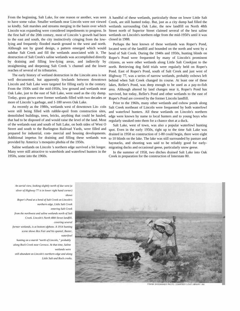
An aerial view, looking slightly north of due west (a
sliver of Highway 77 is in lower right hand corner)
shows
Roper's Pond at a bend of Salt Creek on Lincoln's
northern edge, Little Salt Creekentering Salt Creek
from the northwest and saline wetlands north of SaltCreek. Lincoln's North 48th Street landfill,
covering severalformer wetlands, is at bottom ofphoto. A 1914 hunting
scene shows Rex Fair and his spaniel, Buster,waterfowl
hunting on a marsh "north of Lincoln, " probably
along Rock Creek near Ceresco. At that time, Saline
wetlands were
still abundant on Lincoln's northern edge and alongLittle Salt and Rock creeks.

Today, twin bands of concrete pass over the old lakebed, and thewest quarter of the lake is isolated. Water from its saline seeps isnow carried away by ditches. When Salt Lake was drained in 1958, aLincoln newspaper noted the remains of a hunter's straw blind on thelakebed and that "an eyeless wooden duck mocks the waterless lake."
Beginning in the 1960s, the land around Salt Lake east of 1-80was developed as a residential area. Today, the lake is lined withhouses except on the east and northeast sides, and is supplementedwith water pumped from Oak Creek. Most of the small wetlandsonce found on the east end of the lake have been filled withconstruction spoil. Only degraded remnants remain, and yet, eachspring, a few waterbirds return to them.
In the 1970s and 1980s, most of the remaining small wet- landsalong Superior Street between 27th and 56th streets in north Lincolnwere filled to accommodate a growing industrial park. To the northand west, Lincoln had finally broken through the flood-prone,lowland barrier which had retarded the city's growth in thosedirections.
Straightening Salt CreekEven before the turn of the century, Salt Creek and its tributaries
had been modified to make them more compatible with humaninterests. Sanitary District No.1 of Lancaster County was organizedin 1891 and soon initiated "stream improvement" work such aschannelization and bank stabilization, a mission the District pursueduntil the early 1960s when it ceased to exist, leaving little of SaltCreek and the lower portions of several of its tributaries untouched.
Although flood control was certainly a benefit of channelimprovement, the principal mission of the Sanitary District, at leastinitially, was to ensure that Lincoln's sewage was carried away asquickly and directly as possible. The District's early workstraightened and widened Salt Creek through Lincoln toaccommodate larger peak flows. Levees, constructed principallywith spoil excavated from the streambed and banks, further confinedthe creek to a straight, narrow channel.
Channelization of Salt Creek from Lincoln to Ashland was donepiecemeal, a section at a time, from 1917 to 1942, much of it duringthe 1930s. Salt Creek was straightened by cutting off meanderingloops of the original channel, and thereafter, its velocity increased,widening and deepening the channel.
Channel modifications on Salt Creek and its tributaries aboveLincoln were limited to relatively minor channel- straighteningprojects undertaken by individuals. In the 1950s, Salt Creek south ofLincoln was described as "small and tor- tuous, its banks overgrownwith trees and brush, with high banks forming natural levees." Thiscondition, described in rather undesirable terms in a 1957 U.S. ArmyCorps of Engineer's report, is today protected, in part for those samenatural features, as part of Lincoln's Wilderness Park.
In addition to modifying Salt Creek itself, the Sanitary Districtaltered the channels of several Salt Creek tributaries in the Lincolnarea.
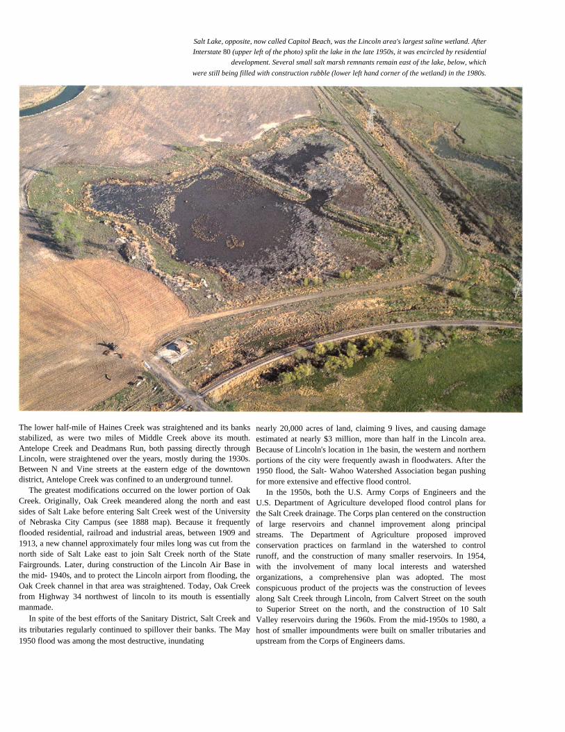
Salt Lake, opposite, now called Capitol Beach, was the Lincoln area's largest saline wetland. AfterInterstate 80 (upper left of the photo) split the lake in the late 1950s, it was encircled by residential
development. Several small salt marsh remnants remain east of the lake, below, whichwere still being filled with construction rubble (lower left hand corner of the wetland) in the 1980s.
The lower half-mile of Haines Creek was straightened and its banksstabilized, as were two miles of Middle Creek above its mouth.Antelope Creek and Deadmans Run, both passing directly throughLincoln, were straightened over the years, mostly during the 1930s.Between N and Vine streets at the eastern edge of the downtowndistrict, Antelope Creek was confined to an underground tunnel.
The greatest modifications occurred on the lower portion of OakCreek. Originally, Oak Creek meandered along the north and eastsides of Salt Lake before entering Salt Creek west of the Universityof Nebraska City Campus (see 1888 map). Because it frequentlyflooded residential, railroad and industrial areas, between 1909 and1913, a new channel approximately four miles long was cut from thenorth side of Salt Lake east to join Salt Creek north of the StateFairgrounds. Later, during construction of the Lincoln Air Base inthe mid- 1940s, and to protect the Lincoln airport from flooding, theOak Creek channel in that area was straightened. Today, Oak Creekfrom Highway 34 northwest of lincoln to its mouth is essentiallymanmade.
In spite of the best efforts of the Sanitary District, Salt Creek andits tributaries regularly continued to spillover their banks. The May1950 flood was among the most destructive, inundating
nearly 20,000 acres of land, claiming 9 lives, and causing damageestimated at nearly $3 million, more than half in the Lincoln area.Because of Lincoln's location in 1he basin, the western and northernportions of the city were frequently awash in floodwaters. After the1950 flood, the Salt- Wahoo Watershed Association began pushingfor more extensive and effective flood control.
In the 1950s, both the U.S. Army Corps of Engineers and theU.S. Department of Agriculture developed flood control plans forthe Salt Creek drainage. The Corps plan centered on the constructionof large reservoirs and channel improvement along principalstreams. The Department of Agriculture proposed improvedconservation practices on farmland in the watershed to controlrunoff, and the construction of many smaller reservoirs. In 1954,with the involvement of many local interests and watershedorganizations, a comprehensive plan was adopted. The mostconspicuous product of the projects was the construction of leveesalong Salt Creek through Lincoln, from Calvert Street on the southto Superior Street on the north, and the construction of 10 SaltValley reservoirs during the 1960s. From the mid-1950s to 1980, ahost of smaller impoundments were built on smaller tributaries andupstream from the Corps of Engineers dams.

Salt Creek was straightened by cutting off its meandering loops, many of which, like those northwest of Waverly,below, are still visible. Although many saline wetlands have been destroyed or altered, the location of formersaline wetlands can be identified by the soil types with which they are associated, indicated by the salmon coloron the map, opposite.
Since construction of levees through Lincoln in the 1960s,modifications to Salt Creek and its tributaries have been com-paratively minor, principally maintenance and bank stabilization.Salt Creek has not flooded in the Lincoln area since 1963. Salt Creekand its tributaries finally seem under control, but at the expense ofthe region's formerly abundant wetlands.
Head-cutting TributariesCompared to Salt Creek and the lower reaches of its tributaries in
the Lincoln area, Little Salt Creek and Rock Creek to the north weretreated with gloved hands. Settlement of their watersheds was muchlike that of most of rural eastern Nebras- ka. Small towns sprang uphere and there, county roads criss- crossed on the mile lines, andfarmers plowed what land could be farmed. What could not beplowed was used for pasture. Because much of the bottomland wastoo wet to farm and periodically flooded, it remained untilled and innative grass. Many wetlands escaped destruction because theyattracted waterfowl. Some were purchased outright by waterfowl
hunters, others were leased from farmers by hunters. Although salinewetlands along Little Salt Creek and Rock Creek escaped destructionfrom urban sprawl, substantial losses and degrada- tion occurred asside effects of agriculture.
A few wetland sites were tiled and drained. More often, nativevegetation declined in abundance or disappeared and was invadedby less desirable species because of chronically poor pasturemanagement. Probably the greatest alteration of saline wetlands inthe Little Salt Creek and Rock Creek drainages resulted from thechannelization of Salt Creek. With its course straightened andconfined, the water velocity of Salt Creek increased and its channelcut deeper. In turn, Salt Creek's tributaries began head-cutting,carving deeper into their beds to adjust their gradients, leavingeroded, unstabilized banks. Lowered streambeds had an indirect,but profound, effect on wetlands associated with Salt Creek and itstributaries.
Historically, saline wetlands in northern Lancaster and southernSaunders counties were filled principally by runoff from surrounding


uplands, and by the high-water flows of streams which periodicallyspilled into the floodplain's basins and depressions. Springs andseeps contributed water to some wetlands on a more regular butlimited basis.
As channels cut deeper, they could accommodate higher flows,and adjacent wetlands were less frequently replenished. Although thehydrologic relationship between Salt Creek tributaries and theirstream-side wetlands is not completely understood, it is suspectedthat a deeply entrenched creek functions much like a drainage ditch,lowering the water table, at least immediately adjacent to the creekwhere most wetlands are located. As a consequence, groundwaterseeps away from wetlands more rapidly than it once did.
The conversion of uplands in the Salt Creek watershed fromgrassland to cropland has also affected saline wetlands. Years
of runoff from surrounding uplands deposited silt in manydepressions where wetlands existed. Today, most surviving wetlandsin the Salt Creek drainage are shallower than they once were, andhave a diminished water-holding capacity.
Unlike Salt Creek, Little Salt Creek and Rock Creek escapedchannelization. From the air, oxbows are still evident, and some arefilled with water. Most wetlands associated with Little Salt Creekare along its lower reach. The most extensive complex of salinewetlands along Rock Creek is in a basin four miles southeast ofCeresco where the North Fork merges with Rock Creek. Below themouth of the North Fork there are fewer wetlands, and croplandedges up to the banks of Rock Creek.
Birds of the BasinsDuring the last century, more than 230 species of birds have been
reported from the salt basins of Lancaster County, more

than half the total number of species reported for the state. Ofparticular interest are the waterbirds. At the turn of the century, thebird life of Salt Lake west of Lincoln and of other saline wetlands inthe area was lavished with attention, largely because of the wetlands'uniqueness and their close proximity to University field naturalists.Among the waterbirds they noted during migration were western andeared grebes; Caspian, Forster's, black and least terns; Hudsonianand marbled god- wits; white-faced ibis; herring gulls; northernphalaropes; buff- breasted sandpipers; red knots; long-billed curlews;and snowy, mountain, American golden and black-bellied plovers.Short- eared owls and northern harriers were probably regular nestersin the low grasslands associated with the saline wetlands of SaltCreek and its tributaries, as were small songbirds which fre- quentlow grasslands and marsh edges. Most species of ducks and geese
reported in Nebraska frequented Salt Lake. A century ago, king rails,snowy egrets and the now-threatened piping plover nested near or onits shores.
In recent years, there have been unexpected sightings of black andking rails, black-necked stilts, white-faced ibis and black-leggedkittiwakes in the remnant salt marshes of Lan- caster County.Uncommon breeders, such as the great-tailed grackle, commonmoorhen, king rail and least bittern, have been observed nesting.
Just as shorebirds and waterfowl were attracted to the salinewetlands, so too were hunters. At the turn of the century and for somedecades thereafter, these wetlands were a frequent close- to-townhunting destination:
During the fall and spring migrations of the water fowlit [Salt Lake] seems to be a very attractive spot for them. Duringthe two seasons there is scarcely a day but that one may see one ormore flocks of ducks or geese, and numerous shore birds. There isso little concealment that the ducks do not have much trouble inkeeping out of range of a gun. Most ducks are killed from boats.Two local hunters the past fall killed 157 ducks of various speciesduring six afternoons in a boat. Days when, in a twenty or thirtymiles' tramp along the creeks one will not see a duck, there will beseveral nice flocks at the lake. I have seen quite often as many asfour or five thousand ducks on the water at one time.
J.S. Hun/et; 1899.
Wetlands associated with lower Salt Creek in the Ashland area,several ofwhich were saline, were the frequent destination of SandyGriswold, sporting editor of the Omaha World-Herald from 1898 to1929, particularly when common snipe, “jacks," as he frequentlyreferred to them, were pausing during migration. Even then, hecould foresee the day when these wetlands would be a thing of thepast:
Continued ditching and tiling have left these once almostlimitless bog lands largely in a perfectly tillable condition, andthe farmers up there consider them to be the very choicest ofall the choice agricultural territory that abounds in theneighborhood, and the jacks will doubtless ere many yearssurrender that scope of country entirely for better and broadergrounds. Huge drains and ditches crisscross the old grounds inall directions, and while there are still the struggling andisolated pools remaining, the drainage is so perfect that thereis but little available grounds surrounding them. The progressand thrift of the American farmer is something that even thejacksnipe cannot check, and if the ravages of improve- ment,to use a somewhat anomalous expression, seem great today,what will they seem ten years hence?
Omaha World-Herald, April 25, 1915.
Channelization increased Salt Creek's velocity, and its channel cut deeper.In turn, Salt Creek's tributaries carved deepe r into their beds, and couldaccommodate higher flows. Thus, streamside wetlands were less frequentlyreplenished when creeks flooded, and groundwater seeped away morerapidly. This process is illustrated by eroded gullies fingering out into asaline wetland adjacent to Little Salt Creek, left.

During the last century, more than 230 species of birds have been reported from Lancaster County salt marshes.Once, a varied array of waterbirds frequented these wetlands. Today, the kinds and numbers are more limited,but still include such rarities as white-faced ibis, below, and more common species such as the American bittern,opposite.
Because saline wetlands are characteristically shallow, and theirwaters frequently retreat, revealing expanses of mudflats, they werefavored by migrating shore and wading birds. Larger waterbirds,particularly the puddle ducks-mallards, teal, gadwall, wigeon,shovelers and pintails-found the more permanent wetlands withstable water levels attractive. Because it was the largest of the salinewetlands, Salt Lake, west of Lincoln, also attracted diving ducks-canvasbacks, redheads, scaup, buffieheads and ruddy ducks. Geese,especially snow
geese, regularly layover on the saline wetlands during springmigration, particularly on the Ceresco flats and even on CapitolBeach Lake until Lincoln encircled it in the 1960s. Snow geese stillpause on wetlands near Ceresco during spring migration when thewetlands hold adequate water, and they are occasionally taken byhunters in the fall.
Beetles, not birds, provide a curious sidelight to the fauna of SaltLake. At the turn of the century (as they do today) tiger beetlesattracted as much, perhaps more, attention from

University naturalists than did the rich variety of bird life. Severalspecies of tiger beetles associated with wet saline sites are found inthe Salt Creek drainage, but of particular interest is a variety of onespecies, Cicindela nevadica lincolniana, known only from thesaltflats of two saline wetlands near Lincoln. The large number ofspecimens in University of Nebraska collections indicate this tigerbeetle was once abundant. Today, because of the draining and fillingof salt basins, its populations are much reduced.
Salt-loving PlantsThe process by which salts concentrate in floodplain soils of the
Salt Creek drainage system is not fully understood. As for mostnatural phenomena, there is probably no single explanation. Springsand seeps issuing from exposed Dakota sandstone along streams oron the margins of basins, or up through soils on the basins' floors,are the obvious sources of these briny waters. For thousands ofyears, these saline waters flowed into basins and streams in the SaltCreek watershed, and the salts were concentrated by repeatedevaporation. While not all saline wetlands are fed by saltwatersprings, the natural movement of water and periodic floodingprobably carried salt-impregnated waters throughout the floodplain.
Less direct natural processes could also contribute to theaccumulation of salts. It is likely that salts are leached from someupland soils, carried by runoff into the floodplain, and concentratedby evaporation, much as they are in alkaline wetlands in Nebraska'swestern Sandhills. It is also probable that salt-laden waters fromshallow aquifers are wicked to the surface during prolonged dryperiods.
What is known is that Dakota sandstone deposits are the pathwaythrough which saltwater moves to the surface in the Salt Creekdrainage, and year after year, as surface water evaporated during dryperiods, salt concentrations in soils and wetlands increased. In time,salt levels in the upper 12 inches of these silty-clay soils were highenough to dictate the plant life that could grow there. It was at thisstage that freshwater wetlands became saline wetlands.
Plants, like animals, have evolved many strategies for sur- vival.Some are generalists, adapted to a broad range of growing sites;others are specialists and can survive only where an exact mix ofsoil type, water chemistry, moisture content, exposure to the sun andevaporation rate occurs.
Salt-tolerant plants are specialists, so precisely adapted to theirsaline environment they are unable to compete with plants

found in prairie or freshwater wetlands. Conversely, few other plantscan compete with salt-tolerant plants in the saline wetland'sinhospitable environment.
No one saline wetland is exactly like another. Each is shaped byits physical circumstances and a century of alteration by man. Somesaline wetlands, particularly the larger ones, like Salt Lake west ofLincoln, occur principally where major tributaries merge with SaltCreek, and are easily recognized as basins. Others are smaller,occupying a relatively narrow strip of floodplain between a SaltCreek tributary and the hills which confine it. Some saline plantcommunities are no more than narrow bands at the edges of salinestreams.
Compared to most plant communities, the number of species in asaline wetland is typically small, and one species usually dominatesin abundance and coverage on a particular part of the wetland. It isunusual for a single wetland to have all species of salt-tolerant plantsnative to the region, and the most complete communities of salt-tolerant plants are found on more highly saline basins associatedwith Salt and Little Salt creeks. While many salt-tolerant speciesoccur in the Rock Creek drainage, they do not develop extensivesaltflat communities, probably because of lower soil-salinity levelsin those wetlands.
The site where a particular salt-tolerant plant grows is dic- tatedby precise distinctions in degree of soil saturation and salinity. Theseenvironmental conditions are in a constant state offlux, andconsequently, so too are boundaries separating plant communities.For convenience, we can imagine a basin where all salt-tolerantspecies are present and arranged in an orderly, albeit simplified,transition from the center to the margins.
If the center of a basin holds water most of the year, it maysupport an aquatic plant community. On a saline wetland, sagopondweed is the most common submerged aquatic plant. At thewater's edge, colonies of prairie bulrush, narrow-leaved cat- tail, orwidgeon grass may establish. Often, small depressions, called pans,are found elsewhere in the basin, and hold water consistently enoughto support the same aquatic plants. Frequently, the most permanentwater is not found at the center of
the wetland at all, but below a seep near the basin's margin, and it ishere that colonies of broad-leaved cat-tail can be found. As waterfrom seeps flows to the center of the wetland, salt concentrationsincrease, and broad-leaved cat-tail is replaced by more salt-tolerantspecies such as narrow-leaved cattail and prairie bulrush.
Encircling the aquatic plant community is the saltflat, where asaline wetland's most interesting plant communities grow. Typically,the saltflat dries each year, or several times a year. The soils of thesaltflat are mucky, with a high clay content. Because clay particlesare small, soil aeration is poor and evaporation reduced, resulting insoils with excellent water- holding properties.
Even on the seemingly uniform saltflat, there are subtleenvironmental distinctions which dictate where particular plantspecies can grow. Soils on the inner portion of the saltflat remainmore moist, keeping salts in solution. The outer portion of the saltflatdries deeper and more frequently, and salt precipitating out formswhite encrustations on the soil surface. If the entire basin dries forextended periods each year, a saltflat will also occupy the center ofthe basin.
The dominant plant on the innermost band of the saltflat issaltwort, a short, compact, succulent plant, usually four to eightinches tall. Under optimum growing conditions, saltwort plants growclose together, forming compact colonies, but at less favorable sitesthey assume a miniature shrub-like appearance and are more widelyspaced. Saltwort has occasionally been found growing at onelocation in central Kansas, but Lancaster County, Nebraska isconsidered the southernmost permanent extent of the species' range.
Encircling the saltwort, on slightly drier portions of the saltflatwith higher salt concentrations, is a band of sea blite. Typical ofmany saline plants, sea blite has narrow, nearly round, fleshy-to-succulent leaves. A bushy plant, it may reach 18 inches in height,and in the fall turns a rich, reddish purple. Like saltwort, individualplants are widely spaced at highly saline sites, and develop a low,spreading form.
Although usually found in pure stands, sea blife is often in thecompany of saltwort and inland salt grass. A water-filled, two-inch-deep hoofprint in a sea blite colony may create a micro-habitat wheresaltwort establishes. Saltgrass growing on a saltflat exists at the limitof its tolerance for soil saturation and salinity levels. Consequently, itis dwarfed in size and grows as isolated plants. Both saltwort and seablite are sensitive to drought, and may disappear completely duringprolonged dry periods. Both, however, are annuals and produceabundant seed crops during favorable years, seeds which can liedormant until acceptable conditions return.
The greatest diversity of plant species on a saline wetland isfound in a transition zone between the saltflat and surroundingprairie. Soils in this zone are saturated or inundated frequentlyenough and for long enough periods to be considered a part of thewetland, but for too short a duration to develop salt con- centrationswhich favor plants tolerant of highly saline soils. Within thistransition zone, salinity levels decline, and two distinctive bands ofvegetation establish, each with its own characteristic group ofplants.
The band encircling the saltflat is dominated by two species,foxtail barley during spring and early summer, and marsh elderfrom midsummer into autumn.
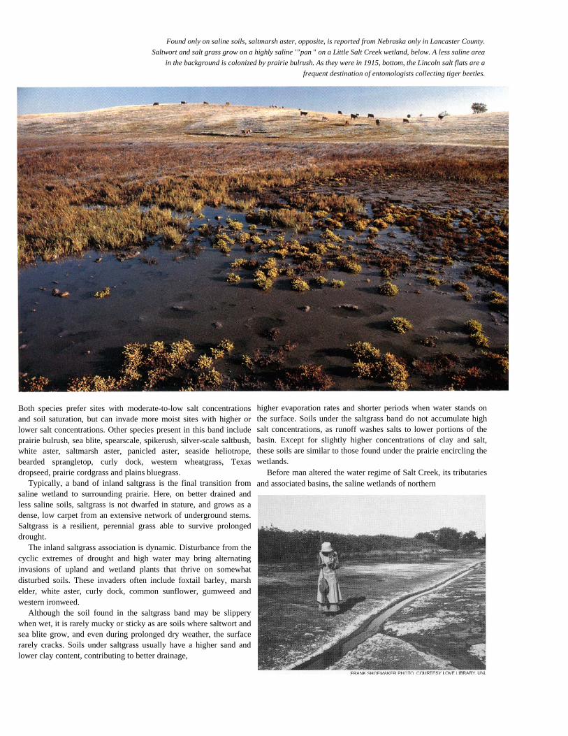
Found only on saline soils, saltmarsh aster, opposite, is reported from Nebraska only in Lancaster County.Saltwort and salt grass grow on a highly saline '”pan " on a Little Salt Creek wetland, below. A less saline area
in the background is colonized by prairie bulrush. As they were in 1915, bottom, the Lincoln salt flats are afrequent destination of entomologists collecting tiger beetles.
Both species prefer sites with moderate-to-low salt concentrationsand soil saturation, but can invade more moist sites with higher orlower salt concentrations. Other species present in this band includeprairie bulrush, sea blite, spearscale, spikerush, silver-scale saltbush,white aster, saltmarsh aster, panicled aster, seaside heliotrope,bearded sprangletop, curly dock, western wheatgrass, Texasdropseed, prairie cordgrass and plains bluegrass.
Typically, a band of inland saltgrass is the final transition fromsaline wetland to surrounding prairie. Here, on better drained andless saline soils, saltgrass is not dwarfed in stature, and grows as adense, low carpet from an extensive network of underground stems.Saltgrass is a resilient, perennial grass able to survive prolongeddrought.
The inland saltgrass association is dynamic. Disturbance from thecyclic extremes of drought and high water may bring alternatinginvasions of upland and wetland plants that thrive on somewhatdisturbed soils. These invaders often include foxtail barley, marshelder, white aster, curly dock, common sunflower, gumweed andwestern ironweed.
Although the soil found in the saltgrass band may be slipperywhen wet, it is rarely mucky or sticky as are soils where saltwort andsea blite grow, and even during prolonged dry weather, the surfacerarely cracks. Soils under saltgrass usually have a higher sand andlower clay content, contributing to better drainage,
higher evaporation rates and shorter periods when water stands onthe surface. Soils under the saltgrass band do not accumulate highsalt concentrations, as runoff washes salts to lower portions of thebasin. Except for slightly higher concentrations of clay and salt,these soils are similar to those found under the prairie encircling thewetlands.
Before man altered the water regime of Salt Creek, its tributariesand associated basins, the saline wetlands of northern


Saltwort and inland saltgrass, below, are characteristic salt-tolerantplants found on Nebraska's saline wetlands. Pintails, opposite, as well as numerous other species ofduck.s', geese and other waterbirds, still pause during their spring andfall migrations on remnant saline wetlands.
Lancaster and southern Saunders counties were dominated by salt-tolerant plant communities. Channelization, draining, filling, diking,diversion, supplemental pumping with fresh water or somecombination of these alterations deprived many saline wetlands ofwater, or altered the delicate balance of salinity which created thespecialized environment where salt-tolerant plants thrived. Today,only remnants of Nebraska's salt marshes remain, and the salt-tolerant plants are threatened by competition from less specializedfreshwater and upland plant species.
Preserving the RemnantsAlthough not be comprehensive design, a century of growth by
Nebraska's capital city and modifications of Salt Creek and itstributaries have destroyed nearly all the region's saline wetlands.Even before settlement of the region began, the saline wetlands ofLancaster and Saunders counties were perhaps the
most restricted natural community in Nebraska. Historical ref-erences documenting the original number and acreage of thesewetlands are limited, and typically each account describes only anindividual site. An exception is a November I, 1862, news item inthe Nebraska Advertiser: In that article, a Scientific Americancorrespondent estimated that four basins near Lincoln covered atotal of 16,000 acres. No information has been found describingother saline wetlands in the Salt Creek water- shed, but soils thatevolved under saline wetlands are fingerprints of where they havebeen.
A 1990 inventory of the saline wetlands in Lancaster andSaunders counties, funded in part by the U.S. EnvironmentalProtection Agency and conducted by the Nebraska Game and ParksCommission, estimated that only 1,200 acres of saline wetlandsremain in the Salt Creek and Little Salt Creek

drainages near Lincoln. The inventory identified 133 saline wetlandsand 99 freshwater wetlands that once were saline. While they rangedin size from approximately one acre to just over 200 acres, themajority were smaller than 20 acres. Not one of the saline wetlandshad escaped the adverse effects of overgrazing, silt deposition,drainage, filling or dilution with fresh water. Virtually all of thesesaline wetlands are fragmented remnants which have beenextensively modified and degraded.
Wetlands are among the earth's most productive natural factories,converting raw materials of sun, water and soil nutrients into analmost incomprehensible array of self-perpetuating life forms. Theimportance of wetlands to wild creatures is especially evident duringthe breeding season, when they are crowded to capacity. Wetlandsare equally valuable to people. Some of the services they render tomankind are evident, others are not.
Because of their proximity to a large and growing urban center,the saline wetlands of Lancaster and Saunders counties can continueto provide enjoyment and recreation to hunters, birdwatchers, naturephotographers and others who occasional- ly need to retreat from thebustle of city life. They are natural laboratories with tremendouspotential as outdoor classrooms for scholars ranging from elementaryschool students who have never seen a marsh, to university graduatestudents delving into the subtle distinctions between tiger beetlespecies and races.
But wetlands perfonn other, less heralded, services. wetlands arenatural pollution controls, trapping, and often rendering hannless,pesticides, fertilizers and sediment washed from lawns and fieldsbefore they can contaminate streams or under- ground aquifers.Because of their location on a floodplain, saline wetlands provideflood control by capturing heavy runoff and releasing water slowlythrough seepage and evaporation. All these functions providednaturally by wetlands are particularly important near populationcenters where man's impact on the environment is greatest.
In the 1980s, the unique qualities and benefits of easternNebraska 's saline wetlands became more widely recognized, andefforts were initiated to preserve and restore the fragmentedremnants. An action as simple as plugging a drain tile or filling aditch and letting nature take its course is often all that is required torestore a degraded freshwater wetland. However, reestablishinghistoric water levels and regimes is only the first step to restorationof a saline wetland. The wetland must then be allowed to fluctuatebetween periods of high water and periods of drying to restore thecomplex soil and water chemistry which favored their unique plantcommunities. After years of being dry, the downward movement ofwater in a fonner wetland may have leached salts from the soil. Therestored wetland may initially revert to a freshwater wetland.
Deepened stream channels adjacent to saline wetlands, or

altered flows from spring seeps make restoration difficult ifnotimpossible at some sites. Pumping water from shallow saline aquifersinto wetlands to replace saline water once supplied by natural seeps,and constructing small dams to prevent further down-cutting bystreams and to restore former streambed levels, are promising butuntested remedies.
Some saline wetlands were deepened by excavation or diking,and periodically filled with fresh water to maintain more permanentwater levels. Such wetlands dried less frequently than they wouldhave naturally, and salts were forced deeper into the soil, notconcentrated near the surface. In time, these former saline wetlandsbecame freshwater wetlands. Restoration of such sites requires there-establishment of historic water levels by the removal of dikes andthe filling of excavated areas. As a more normal water regimereturns, evaporation will again draw salts to the surface by capillaryaction, and salt-tolerant plants will reestablish if they or their seedsare still present.
Seeds produced by salt-tolerant plants can lie dormant in wetlandsoils for many years. This seed bank serves to buffer the effects ofdrought or high-water years when growing conditions aretemporarily unfavorable. When altered wetlands are restored, theselong-dormant seeds can reestablish native, salt- tolerant plantcommunities. Unfortunately, this seed bank has a limited shelf-life.Salt-tolerant plants may have to be reintroduced to saline wetlandswhich have been dry or inundated with fresh water for too manyyears. Restoration of the complex hydrology which created salinewetlands is possible, but expensive, time consuming and only thefirst step toward reestablishing a saline wetland in all its complexity.
Currently, nearly 1,000 acres of land containing some remnantsaline wetlands are protected by the Nebraska Game and ParksCommission on the Jack Sinn Memorial Wildlife Management Areaon Rock Creek south of Ceresco. This area provides habitat for bothupland birds and waterbirds, while preserving saline wetlands. In1990, an earthen dike was constructed to capture runoff and create ashallow wetland of about 17 acres. This shallow wetland is designedto dry periodically and provide habitat for both waterbirds and salineplants. Additional dikes may be constructed in the future. Othersaline wetlands may be restored by removing silt which has washedin over the years and decreased their water-holding capacity.
Two saline wetland areas near Ceresco are protected underperpetual conservation easements by the Lower Platte South NaturalResources District. Under these easements, landowners receive aone-time payment based on the appraised value of the land and itsincome-producing potential. The easement agree- ment remains withthe land through subsequent owners. Terms of each easement arespecifically tailored to the site. While land-use restrictions to protectthe wetland are imposed, grazing is often permitted, but the numberof animals and the duration they are pastured is regulated to protectthe natural vegetation. The Lower Platte South NRD easementprogram has targeted wetlands for protection, particularly those inthe Rock Creek and Little.Salt Creek drainages.
Arbor Lake, a saline wetland just north of Lincoln, was acquiredby the City of Lincoln as mitigation for the destruction of a smallersaline wetland filled when the Capitol Parkway West bypass wasconstructed southwest of downtown Lincoln. Arbor Lake ismanaged for the city by the Nebraska Game and Parks Commission.
A water control structure is now in place to maintain historic waterlevels, to reestablish salinity levels, to encourage the recovery ofsalt-tolerant plants and to provide migratory habitat for shorebirdsand wading birds. Arbor Lake is open to public access, and willhave an elevated boardwalk and observation platform to allowvisitors to observe a saline wetland's plant and animal life withoutthreatening its survival.
In the course of a hundred years, we reshaped the Nebraskalandscape. That we did so is understandable. During the earlydecades after settlement, extracting a living from the land was

Nebraska Salt Marshes was funded in part by the U.S. EnyironmentalProtection Agency under assistance agree;ment number X 007451-01-0 withthe Nebraska Game and Parks Commission. It may not necessarily reflectthe views of the EPA, and no official endorsement should be inferred.Additional copies are available from the Nebraska Game and ParksCommission, P.O. Box 30370, Lincoln, NE 68503. Text by Jon Farrar andRichard Gersib. Photos, unless otherwise credited, by Jon Farrar. PublishedJuly 1991.
Winter's snow, trapped by prairie cordgrass, promises wet salt marshes in early spring.a matter of survival. Later, intensive use of the land brought ahigher standard of living. Not until recent decades did weglanceback and realize the cost to our natural heritage of thisprosperity. Most of Nebraska's other natural ecosystems were oncemeasured in hundreds of square miles, and some still are. Whileproportionately much of each of those ecosystems was destroyed,significant amount remain. But even before settlers scraped saltfrom the Salt BasIn, salIne wetlands were few, both , in number andextent. Today but a handful remain. They are the ! state's mostimperiled natural community. 1