wfldb methodologicalguidelines v3.0 - quantis-intl.com · ! ! 3!! tableof&content&!...
TRANSCRIPT

1
World Food LCA Database
Methodological Guidelines for the Life Cycle Inventory of Agricultural Products
Date: 16 July 2015
Version: 3.0
Authors: Xavier Bengoa, Quantis
Vincent Rossi, Quantis
Sebastien Humbert, Quantis
Thomas Nemecek, Agroscope
Jens Lansche, Agroscope
Patrik Mouron, Agroscope
Eliane Riedener, Agroscope

2
Acknowledgements These guidelines are a result of the World Food LCA Database (WFLDB) project, initiated and led by Agroscope (www.agroscope.admin.ch) and Quantis (www.quantis-‐intl.com), and funded by the French Environment and Energy Management Agency (ADEME), the Swiss Federal Office for the Environment (FOEN), Bayer CropScience, General Mills, Kraft Heinz Company, Mars, Mondelēz International, Monsanto, Nestlé, PepsiCo, Syngenta and Yara. The following people contributed to reviewing these guidelines as part of a closed consultation procedure (in alphabetical order). We are grateful for their valuable inputs.
• Assumpció Antón, IRTA, Spain • Hanna Hartikainen, LUKE, Finland • Dominique Maxime, CIRAIG, Canada • Hannele Pulkkinen, LUKE, Finland • Greg Thoma, University of Arkansas, USA • Hayo van der Werf, INRA, France
Recommended citation Nemecek T., Bengoa X., Lansche J., Mouron P., Riedener E., Rossi V. & Humbert S. (2015) Methodological Guidelines for the Life Cycle Inventory of Agricultural Products. Version 3.0, July 2015. World Food LCA Database (WFLDB). Quantis and Agroscope, Lausanne and Zurich, Switzerland. Disclaimer
Anyone is free to use or refer to World Food LCA Database methodological guidelines when developing LCI data, or when performing a life cycle assessment. However, the WFLDB project managers and partners cannot be held responsible for any action or decision made upon using these guidelines as a scientific basis for any type of environmental assessment or claim.

3
Table of content
1 Introduction ........................................................................................................................... 10 1.1 Background ............................................................................................................................ 10 1.2 Objectives ............................................................................................................................... 10 1.3 Project organisation ............................................................................................................... 11
2 General principles ................................................................................................................... 12 2.1 Database structure ................................................................................................................. 12 2.2 Naming convention ................................................................................................................ 12 2.3 Functional unit and reference flows ...................................................................................... 13 2.4 System boundaries ................................................................................................................. 14
2.4.1 Crop production .............................................................................................................. 14 2.4.2 Animal production ........................................................................................................... 15 2.4.3 Food transformation ....................................................................................................... 16
2.5 Data representativeness ........................................................................................................ 17 2.5.1 Geographical coverage .................................................................................................... 17 2.5.2 Time ................................................................................................................................. 17 2.5.3 Technology ...................................................................................................................... 18
2.6 Allocation ............................................................................................................................... 18 2.6.1 General principles ........................................................................................................... 18 2.6.2 Crop co-‐products ............................................................................................................. 19 2.6.3 Animal co-‐products at farm ............................................................................................ 19 2.6.4 Animal co-‐products at slaughterhouse ........................................................................... 19 2.6.5 Co-‐products from dairy processing ................................................................................. 20 2.6.6 Transport and infrastructure ........................................................................................... 20
3 Inventory modelling ............................................................................................................... 21 3.1 Principles for data collection .................................................................................................. 21
3.1.1 Decision tree for identifying best data ............................................................................ 21 3.1.2 Definition of primary and secondary data ...................................................................... 21 3.1.3 Defining input categories ................................................................................................ 21 3.1.4 Definition of degrees of detail ......................................................................................... 22 3.1.5 Definition of expert consultation .................................................................................... 22
3.2 Yield ........................................................................................................................................ 23 3.2.1 Crop products .................................................................................................................. 23 3.2.2 Animal products .............................................................................................................. 23
3.3 Land transformation .............................................................................................................. 23 3.3.1 Definitions: direct and indirect land use change ............................................................. 23 3.3.2 Land use change from crop production .......................................................................... 24
3.4 Land occupation ..................................................................................................................... 26 3.4.1 Land management change effects on soil carbon ........................................................... 26
3.5 Water use ............................................................................................................................... 27 3.5.1 Water types for crop production .................................................................................... 27 3.5.2 Irrigation water consumption ......................................................................................... 27 3.5.3 Irrigation energy use ....................................................................................................... 29 3.5.4 Water emissions .............................................................................................................. 30 3.5.5 Animal production ........................................................................................................... 30 3.5.6 Food transformation ....................................................................................................... 30
3.6 Fertilisers application ............................................................................................................. 30 3.6.1 Estimation of nutrient inputs .......................................................................................... 30

4
3.6.2 Mineral and organic fertilisers, L1 data ........................................................................... 31 3.6.3 Estimation of mineral fertilisers input ............................................................................. 31
3.7 Pesticides application ............................................................................................................. 32 3.8 Packaging ............................................................................................................................... 33 3.9 Direct emissions from crop and animal production ............................................................... 34
3.9.1 Emissions included .......................................................................................................... 34 3.9.2 Overview of emission models ......................................................................................... 35 3.9.3 Ammonia (NH3) ............................................................................................................... 35 3.9.4 Nitrogen oxides (NOx, NO, NO2) ...................................................................................... 38 3.9.5 Nitrous oxide (N2O) ......................................................................................................... 38 3.9.6 Methane (CH4) emissions ................................................................................................ 40 3.9.7 Nitrate leaching to ground water .................................................................................... 43 3.9.8 Phosphorus emissions to water ...................................................................................... 49 3.9.9 Heavy metals emissions to agricultural soil, surface water and ground water ............... 52 3.9.10 Carbon dioxide (CO2) emissions after urea or lime applications ................................... 56 3.9.11 Pesticide emissions ....................................................................................................... 56
3.10 Carbon uptake by plants ...................................................................................................... 57 3.11 Crop production activities .................................................................................................... 58
3.11.1 Machinery for field operations ...................................................................................... 58 3.11.2 Drying ............................................................................................................................ 60
3.12 Animal production activities ................................................................................................ 60 3.12.1 Animal feed production ................................................................................................ 61 3.12.2 Housing, manure management and grazing ................................................................. 61 3.12.3 Slaughtering .................................................................................................................. 62
3.13 Food transformation activities ............................................................................................. 63 3.13.1 General principles ......................................................................................................... 63 3.13.2 Home cooking ............................................................................................................... 63
3.14 Electricity ............................................................................................................................. 63 3.15 Infrastructure ....................................................................................................................... 64 3.16 End-‐of-‐life activities ............................................................................................................. 64
3.16.1 Waste treatment ........................................................................................................... 64 3.16.2 Wastewater treatment .................................................................................................. 64
4 Data quality ............................................................................................................................ 65 4.1 Dataset documentation ......................................................................................................... 65 4.2 Data quality assessment ........................................................................................................ 66
4.2.1 Data quality at dataset level ............................................................................................ 66 4.2.2 Data quality at flow level ................................................................................................. 67
4.3 Quality control procedure ...................................................................................................... 69
5 References .............................................................................................................................. 70
6 Appendices ............................................................................................................................. 76 6.1 World irrigation statistics ....................................................................................................... 76 6.2 Degrees of detail for crop production inputs ......................................................................... 82 6.3 Economic allocation at slaughterhouse ................................................................................. 84

5
List of tables
Tab. 1: Co-‐products from slaughtering ................................................................................................ 20
Tab. 2: Carbon pools accounting in land transformation .................................................................... 26
Tab. 3: Irrigation efficiency EFirr (adapted from FAO 1989) ................................................................. 28
Tab. 4: Energy use for water pumping (depth = 48 m) (derived from UofA (2007) in Nemecek and
Kägi 2007) ............................................................................................................................................ 29
Tab. 5: Overview of the emission models used in the WFLDB and comparison to other databases. . 35
Tab. 6: Emission factors for NH3 after the application of mineral N fertiliser (EEA, 2013, 3.D Table 3-‐
2) in function of the soil pH. ................................................................................................................ 36
Tab. 7: Emission factors for NH3 related to animal production (from EEA, 2013, 3.B Table 3.7, other
sources given in footnotes) for liquid and solid manure storage. The emission factors (EF) refer to the
TAN (total available nitrogen) content of the manure at each stage (kg NH3-‐N/kg TAN). .................. 37
Tab. 8: Emission factors for N2O related to animal production (from EEA, 2013, 3.D Table 3.6). The
emission factors (EF refer to the TAN content of the manure). NA = factor not relevant for solid
manure. ............................................................................................................................................... 40
Tab. 9: Methane conversion factors (Ym) for the conversion of energy intake through feed into
energy lost as CH4. (IPCC, 2006, Tab. 10.12) ....................................................................................... 41
Tab. 10: Maximum methane producing capacities for manure produced by livestock category. ...... 42
Tab. 11: Methane conversion factors for each manure management system for the cool climate,
temperate and warm climates. Factors for warmer climates can be found in IPCC (2006, Tab. 10.17).
Source: IPCC (2006, Tab. 10.17, for anaerobic digestion Umweltbundesamt (2013, p. 288)) ............ 42
Tab. 12: Assumptions for the calculation of CH4 emissions from rice cultivation ............................... 43
Tab. 13: Expected nitrogen mineralisation (Nmin m, kg N per ha and month, from Richer et al. 2014) in
soils with 15% clay, 2% humus and N input from farm manure of 1 livestock unit (LU)/ha in the valley
region. Intensive soil cultivation means treatment by a rotary cultivator or a rotary harrow in the
respective month. In months where there is no intensive soil cultivation, the values “Without
intensive soil cultivation” are used. ..................................................................................................... 44
Tab. 14: Correction factors of nitrate mineralisation (%) for the clay and humus content of the soil. 44
Tab. 15: Risk of nitrogen leaching (fraction of potentially leachable nitrogen of the N applied through
fertilisers in %, from Richner et al. 2014). ........................................................................................... 45
Tab. 16: The correction of the expected nitrate leaching due to fertiliser application in function of
the depth of soil (Richner et al. 2014). ................................................................................................ 45
Tab. 17: Accumulation of the monthly values of nitrate mineralisation, nitrate uptake by the plants
and the nitrate from fertilising for various crops (Richner et al. 2014). The grey cells show the periods

6
during which the values of N mineralisation, N fertilisation and N uptake are added and the leaching
risk is calculated from the sum of these values. In the white cells, the calculation is performed on a
monthly basis. ...................................................................................................................................... 46
Tab. 18: FAO ecozones and their assigned carbon content and annual precipitation. Due to high
variability in precipitation, no values are given for montane ecozones. For these ecozones
precipitation values have to be researched in each individual case. (From Faist Emmenegger et al.
2009) .................................................................................................................................................... 47
Tab. 19: USDA soil orders and their assigned clay contents. (From Faist Emmenegger et al. 2009) ... 48
Tab. 20: Crops and their rooting depth as assumed for calculations. ................................................. 48
Tab. 21: Heavy metal leaching to groundwater according to Wolfensberger & Dinkel (1997). .......... 53
Tab. 22: Average heavy metal contents in mg per kg soil for Switzerland (from Keller & Desaules,
2001). ................................................................................................................................................... 54
Tab. 23: Heavy metal deposition (see Freiermuth 2006). ................................................................... 54
Tab. 24: Heavy-‐metal contents of plant material (mg/kg dry matter, from Freiermuth 2006). .......... 55
Tab. 25: Heavy-‐metal contents of mineral fertilisers [mg/kg nutrient] according to Desaules & Studer
(1993). No data available on Hg. Source: Freiermuth (2006). ............................................................. 55
Tab. 26: Heavy-‐metal contents of farmyard manure and organic fertiliser (mg/kg DM, compiled by
Freiermuth 2006 from from Menzi & Kessler (1998) and Desaules & Studer (1993, p. 152)). Dry
matter (DM) contents from Walther et al. (2001, Tab. 44). ................................................................ 56
Tab. 27: Carbon contents of different fractions of the biomass .......................................................... 58
Tab. 28: Shares of manure management systems for dairy cattle in different regions ...................... 62
Tab. 29: ILCD data quality rating scale (EU-‐JRC 2010a; p. 331) ........................................................... 66
Tab. 29: Pedigree matrix used to define indicator scores for data categories (Weidema et al. 2013; p.
76) ........................................................................................................................................................ 68
Tab. 30: Assumed scores per data category for pedigree matrix indicators ...................................... 69
Tab. 31: Sprinkler and micro irrigated area (ICID 2012) ...................................................................... 76
Tab. 32: Relative areas irrigated with ground water, surface water and non-‐conventional sources
(Siebert et al. 2010) ............................................................................................................................. 77
Tab. 33: Degrees of detail for crop-‐related production inputs ............................................................ 82

7
List of figures
Figure 1: WFLDB project organisation ................................................................................................. 11
Figure 2: System boundaries for crop production systems ................................................................. 14
Figure 3: System boundaries for animal production systems .............................................................. 15
Figure 4: System boundaries for food processing systems .................................................................. 16
Figure 5: System boundaries for home cooking systems .................................................................... 16
Figure 6: Decision tree for identifying the best available data for production inventories ................. 22
Figure 7: Documentation structure related to data collection and modelling .................................... 65

8
Acronyms and abbreviations AGB Aboveground biomass ADEME Agence de l'environnement et de la maîtrise de l'énergie ART Agroscope Reckenholz-‐Taenikon Research Station BGB Belowground biomass BRIC Brazil, Russia, India and China BSI British Standards Institution C Carbon Cd Cadmium CH4 Methane CO2 Carbon dioxide Cr Chromium Cu Copper dLUC Direct land use change DOM Dead organic matter EEA European Environment Agency EF Emission factor EU-‐JRC European Commission -‐ Joint Research Centre FAO Food and Agriculture Organization of the United Nations FPCM Fat and protein corrected milk ICID International Commission on Irrigation and Drainage IDF International Dairy Federation IEA International Energy Agency ILCD International Reference Life Cycle Data System iLUC Indirect land use change IPCC Intergovernmental Panel on Climate Change ISO International Standardization Organization FOAG Swiss Federal Office for Agriculture FOEN Swiss Federal Office for the Environment GRUDAF Grundlagen für die Düngung im Acker-‐ und Futterbau HAFL Hochschule für Agrar-‐, Forst-‐ und Lebensmittelwissenschaften Hg Mercury K Potassium LCA Life cycle assessment LCI Life cycle inventory LEAP Livestock Environmental Assessment and Performance LPG Liquefied petroleum gas LUC Land use change MCF Methane conversion factor N Nitrogen N2O Dinitrogen monoxide or nitrous oxide NH3 Ammonia NO Nitrogen monoxide NO3
-‐ Nitrate NOx Nitrogen oxides Ni Nickel OECD Organisation for Economic Co-‐operation and Development P Phosphorus Pb Lead PEF Product Environmental Footprint PO4
3-‐ Phosphate SALCA Swiss Agricultural Life Cycle Assessment SOC Soil organic carbon TAN Total ammonium N (kilograms N) USDA United States Department of Agriculture

9
UofA University of Arkansas WFLDB World Food LCA Database WWTP Waste water treatment plant Zn Zinc

10
1 Introduction
1.1 Background
Agricultural production and food processing contribute significantly to environmental impacts on global warming, eutrophication and acidification (Pardo and Zufia 2012; Ruviaro et al. 2012; Saarinen et al. 2012). In the last decade, life cycle assessment (LCA) is increasingly used for the quantification of these impacts and to meet the demand for optimization of food production (Notarnicola et al. 2012). For an environmental assessment of food products, the data demand comprises not only the agricultural primary production but also food processing, packaging, transport and waste management. Furthermore, a huge variability of agricultural practices exists within a country and to an even larger extent on a global scale. Existing libraries of life cycle inventory (LCI) data on food are most often:
§ Not transparent enough § Incomplete: only few inventory flows are accounted for, which leads to an incomplete
overview of the impacts of food products and misleading interpretations and conclusions § Inconsistent among each other, due to different approaches and assumptions § Outdated and consequently unreliable § Not regionalized: country-‐specific data are not available or the region under study is not
represented Therefore, it is critical to develop relevant, detailed, transparent, well-‐documented and reliable data to allow for more accurate and comparable LCA in the food sector. This need is being addressed by the World Food LCA Database (WFLDB) project, which was launched in 2012 by Quantis and Agroscope.
1.2 Objectives
The main aim of the WFLDB is to create a database that represents agricultural primary products and processed food products. The geographical focus is global, i.e. products that are dealt on the global market are represented. WFLDB can assist companies and environmental authorities in processes like eco-‐design of food products and Environmental Product Declarations (EPD) and can also be used for academic research. For this purpose, a new set of food inventory data is being developed from existing LCA studies on food products (project partners’ previous LCAs, Agroscope and Quantis existing databases), literature reviews, statistical databases of governments and international organizations (such as the Food and Agriculture Organization of the United Nations), environmental reports from private companies, technical reports on food and agriculture, information on production processes provided by the project partners as well as primary data. A list of products and processes was defined with the objective to represent at least 50% of the global market in mass for selected products and processes. The list has been developed according to the following procedure:
§ An individual list of priorities regarding products and processes was developed from each WFLDB partner based on the “UN Classification of Individual Consumption According to Purpose (COICOP)” classification system
§ FAO statistics (http://faostat3.fao.org/home/index.html; year: 2010) was used to identify the most important net-‐export countries and define the countries that are considered in WFLDB
§ An average priority score for each product and process was calculated § The final list was defined according to priorities and available budget

11
§ Some products or countries were deliberately not selected because LCI data of sufficient quality was already available in other databases
This document describes the methodological approaches and the decisions that have been taken to model the WFLDB datasets within the project. The WFLDB datasets are made available to the project partners exclusively in a first stage. The complete database will then be submitted to and published by ecoinvent after the ecoinvent review process is completed. Revisions that may occur due to this review procedure will be documented in the dataset documentation and are not described in these guidelines.
1.3 Project organisation
Figure 1 illustrates the project organisation. Steering committee: representatives of the project managers (Agroscope and Quantis) and project partners (French Environment and Energy Management Agency ADEME, Swiss Federal Office for the Environment FOEN, Bayer CropScience, General Mills, Kraft Heinz Company, Mars, Mondelēz International, Monsanto, Nestlé, PepsiCo, Syngenta, Yara). The steering committee is the decision-‐making body of the project. It defines priorities regarding the datasets included in the WFLDB, decides on the evolution of the project organisation and appoints members of the advisory board. Project coordination committee: Dr Gérard Gaillard from Agroscope (Head of LCA research group) and Arnaud Dauriat from Quantis (Managing Director of Quantis Switzerland). The coordination committee is responsible for strategic issues and for the good progress of the project. It is also in charge of planning external communications.
Figure 1: WFLDB project organisation
Project Team:
• Quantis: Xavier Bengoa, Laura Peano, Vincent Rossi, Sébastien Humbert, Fayçal Boureima, An de Schryver, Cécile Guignard, Violaine Magaud, Marine Salvi and Marcial Vargas Gonzalez
• Agroscope: Jens Lansche, Patrik Mouron, Eliane Riedener, Thomas Nemecek, Tuija Waldvogel and Hisko Baas
The project team is responsible for conducting the project and achieving its objectives. It defines the scientific basis of the database, gathers and evaluates data sources, models datasets and develops all supporting documentation. Advisory board: international organisations, NGOs and research centres. The advisory board has a consultative role. It assists the steering committee in operational issues, to guarantee the consistency of the WFLDB with other national or international initiatives. It provides an external view on the project management and communication.

12
2 General principles
This document describes the scientific modelling principles, methods and approaches that are applied for the WFLDB datasets. This report aims to present a consistent and transparent methodology that is exhaustive enough to be applicable on a global scale.
2.1 Database structure
The WFLDB aims to be representative of the global market: - For each product, at least 50% of cumulated global exports are represented by the countries
considered - Representative production system for each product in a given country is modelled - Representative production system on a global level for some manufacturing/conversion
processes
The modelling guidelines are based on existing scientific modelling guidelines and are compliant with the following standards:
- Ecoinvent data quality guideline (ecoinvent report No. 1(v3): overview and methodology – data quality guideline for the ecoinvent database version 3) (Weidema et al. 2013)
- ISO 14040 and 14044 (ISO 2006a; 2006b) - ILCD (entry level requirements) (EU-‐JRC 2012)
All datasets in WFLDB are modelled on a unit process level and all methodological choices that have been taken are described in this document and in the dataset documentation to reach a high transparency. Ecoinvent is used as background database.
2.2 Naming convention
The ecoinvent naming convention is applied, as documented in the ecoinvent report No. 1 (v3) “Overview and methodology: Data quality guideline for the ecoinvent database version 3”, chapter 9 (Weidema et al. 2013). Activities (e.g. coffee spray drying) are differentiated from intermediary exchanges – or products – (e.g. coffee, spray dried).
The name of agricultural products datasets explicitly includes the following:
§ Product name (incl. variety, when relevant)
§ Product grade (when relevant)
§ Production scheme (conventional, organic, intensive, extensive, etc.)
§ Production mode (open field, greenhouse heated, greenhouse non-‐heated, etc.)
§ Country of production
Naming of datasets might be adapted if or when the WFLDB is provided as part of another LCI database, LCI data platform or LCA software. Typically, when datasets are published through the European Life Cycle Data Network, they shall follow the compliance rules and entry-‐level requirements (EU-‐JRC 2012) and must therefore be renamed according to ILCD conventions (EU-‐JRC 2010b).

13
2.3 Functional unit and reference flows
In life cycle assessment, the functional unit is the reference for evaluating products, services and activities on a common basis. The reference flow is the amount of product or activity required to fulfil the functional unit. Typically, life cycle inventory (LCI) data rely on a chosen reference flow.
Agricultural datasets (i.e. crop products) are based on a mass reference of one kilogram (1 kg) of output fresh product. The reference flow can therefore be defined as:
1 kg output fresh product, unpackaged, at farm exit gate
The water content of the product is specified in the dataset description.
For live animal production, the reference flow is defined as:
1 kg animal, live weight, at farm exit gate
1 kg fresh chicken eggs, unpackaged, at farm exit gate
1 kg fat and protein corrected milk (FPCM), unpackaged, at farm exit gate
with
1 kg FPCM = 1 kg milk * (0.1226 * %fat + 0.0776 * %true protein + 0.2534) (IDF, 2015)
For transformed food items:
1 kg animal product, unpackaged, at slaughterhouse exit gate (fresh meat)
with different co-‐products (food grade co-‐products, hides and skin, etc.) allocated to the total dead weight of the animal. See section 2.6.4 for more details.
1 kg product, unpackaged, at plant exit gate
For food transformation activities:
Activity datasets, or transformation activities (e.g. slaughtering, drying, home cooking, etc.), can be based on a mass reference of one kilogram (1 kg) of input product, a unitary reference (1 unit), or a time reference (1 min). The reference flow can therefore be defined as:
Transforming 1 kg (or 1 unit) of input product
Cooking 1 kg (or 1 min) of food product
Sub-‐datasets developed for the WFLDB can be based on other reference flows that nevertheless remain consistent with the usual practices in the ecoinvent database (e.g. 1 kWh electricity, 1 MJ heat, 1 m3 irrigating).

14
2.4 System boundaries
The following sections describe the system boundaries defined in WFLDB in three categories: crop production, animal production and food transformation. For both crop and animal production, a cradle to gate approach is chosen while for food transformation1 a gate-‐to gate approach is applied.
2.4.1 Crop production
System boundaries for crop production systems are illustrated in Figure 2. By default conventional seeds are used. On a case-‐by-‐case basis, treated seeds are modelled (e.g., coating). Irrigation water energy and infrastructure, as well as the water extraction from nature are included. Transport of material inputs and on-‐farm transport are included. Drying of cereals before storage is included whether it takes place at the farm or not. Waste and wastewater treatment are included.
Figure 2: System boundaries for crop production systems
Excluded processes are:
§ Animal traction
§ Post-‐harvest processes, except drying and post-‐harvest pest treatment when rendered
mandatory for proper storage of crop products and specific post harvest activities taking
place at the farm (e.g. depulping)
§ Production and storage of animal manure
§ Packaging of output products, unless specifically mentioned
1 The term “food transformation” is used since it covers both industrial food processing and home cooking.

15
§ Labour, commuting and travels of seasonal workers
§ Administrative work
§ Processes that can reasonably be assumed to contribute to less than 1% of the environmental impact (cut-‐off criterion), when no data are available
2.4.2 Animal production
System boundaries for animal production systems are illustrated in Figure 3. All relevant input processes and resources are accounted for. Feed production and processing is included whether it takes place at the farm or externally (hence the dotted line).
Figure 3: System boundaries for animal production systems
Excluded processes are:
§ Pharmaceuticals
§ Packaging of output products, unless specifically mentioned
§ Labour and commuting
§ Administrative work
§ Processes that can reasonably be assumed to contribute to less than 1% of the environmental impact (cut-‐off criterion), when no data are available

16
2.4.3 Food transformation
System boundaries for food transformation systems are illustrated in Figure 4 and Figure 5.
Figure 4: System boundaries for food processing systems
Figure 5: System boundaries for home cooking systems

17
Excluded processes are:
§ Packaging, unless specifically mentioned (e.g. for mineral water)
§ Labour and commuting
§ Administrative work and R&D
§ Cutlery and dishwashing
§ Salt, oil, fat and spices
§ Processes that can reasonably be assumed to contribute to less than 1% of the environmental impact are excluded (cut-‐off criterion), when no data are available
2.5 Data representativeness
2.5.1 Geographical coverage
The World Food LCA Database aims to cover food production activities for a wide set of products and main net-‐exporting countries. The country scale is consistent with other LCI databases, such as ecoinvent, and provides a basis adapted to national regulations and average practices. Assessment of the whole variety of practices for cultivating a given crop in a same country is beyond the scope of the WFLDB project.
Principal producers and exporting countries for each commodity are identified through data of the Food and Agriculture Organization (FAO) (FAOSTAT 2012). National datasets are then combined into either set of global averages [GLO] for each product:
1. Global market average, where the volume (tonnage) exported annually for each country considered in the WFLDB is used as weighting factors. This is typically used for commodities that are purchased on the global market (e.g. maize grain, coffee beans or palm oil).
2. Global production average, where the volume (tonnage) produced annually for each country considered in the WFLDB is used as weighting factors. This average is typically used for products which are not sold on the global market (e.g. milk or asparagus)
2.5.2 Time
Data is representative of current average practices for crop production, animal production and food transformation. Temporal representativeness is especially important for factors that can potentially evolve quickly, such as:
§ Crop yields
§ Application of fertiliser and pesticides (amounts and types)
§ Irrigation practices and requirements (as dictated by precipitation variability)
§ Deforestation rates
§ Electricity mixes
§ Energy consumption for food transformation
As a general rule, data from the period 2009-‐2012 is used. Exceptions are documented in the dataset documentation.

18
Other factors, such as infrastructure or machinery are assumed to be less time-‐dependant and can therefore rely on older data. This may also apply to background datasets from the ecoinvent database.
2.5.3 Technology
In alignment with attributional life cycle inventory databases, the average technology (or practice) is modelled (by opposition to marginal technology or best practice). In crop production, average practice should be understood as conventional agriculture as practiced by a majority of producers. When relevant, it is specified whether the production system is qualified as "intensive". When a specific technology or practice is modelled (e.g. organic production), this is explicitly mentioned in the name of the dataset.
Certified products are modelled in the WFLDB following the principles below:
§ Detailed information on the certification scheme and specifications must be publicly available
§ The certification scheme is critically evaluated and not considered itself a proof of more sustainable practice
§ Certified products are modelled only if there is tangible proof that specifications are duly followed
§ Modelling of certified products is performed on a case by case basis
2.6 Allocation
2.6.1 General principles
Agricultural production systems can provide multiple product outputs: usually one main product and one or several co-‐products or by-‐products. According to ISO 14044 (2006), multi-‐functional and multi-‐product systems should be solved with system expansion, or, when not possible, with allocation. The inputs and outputs shall be allocated to the different products according to clearly stated procedures. This methodological choice shall fit with the goal situations of the WFLDB.
ILCD-‐compliance requires differentiating by the archetype of goal situations A, B, or C (EU-‐JRC 2010a, p.87 and p.268). The WFLDB is of a purely descriptive character, i.e. represents current technologies used in different countries and based on average or generic data, and existing benefits and negative interactions with other systems are not considered. Thus the WFLDB refers to goal situation C1.
Furthermore, WFLDB datasets do not consider changes on a macro level, i.e. process changes in background systems such as changes in the market structure of raw materials or energy carriers. Attributional modelling, with allocation used to deal with multifunctionality, is therefore adequate. According to the ILCD, in a first step the “physical causality” shall be considered and if not feasible “market price” shall be used as allocation criterion. WFLDB datasets can be used for several purposes and products and co-‐products of a production system can be used in different utilization pathways. A “physical causality” can only be derived for a specific utilization of product and co-‐products. Therefore, in WFLDB “physical causality” is used to define allocation criteria, when a utilization pathway of a product and co-‐products from a production system is known and clearly defined. If several potential uses exist, it is not possible to define one “physical causality” that fits for all potential applications and consequently, economic allocation criteria are applied in these cases. Such an approach is consistent with ISO 14044 (2006b).

19
2.6.2 Crop co-‐products
The use of products and co-‐products from crop production systems is not defined in an LCI database like WFLDB. For example, wheat can be used as food, feed or for production of bioethanol. Straw can either be used as bedding material, as feed, for combustion or for production of 2nd generation bioethanol. Different physical causalities would need to be applied in each of these cases; hence it is not possible to develop a single “physical causality” that fits for all potential applications.
Therefore, economic allocation has been found to be required and is used by default for crop co-‐products at the farm. Since only traded products and co-‐products are addressed, price information is available. Prices are calculated as average values of the years 2009-‐2012, when available. This allocation rule applies to main products and co-‐product (e.g. for co-‐products at farm such as grains and straw, oil and press cake).
The economic allocation principle is also used for animal feed. Nguyen & van der Werf (2013) investigated the influence of the allocation rule for animal feed in carbon footprints of meat. Although for the single feed components the allocation rule is very important, on the level of meat, the influence is relatively small. Furthermore, the different co-‐products of the food and feed chains have different uses, so that a common physical causality is not applicable. For these reasons, the economic allocation is also used for animal feed.
2.6.3 Animal co-‐products at farm
In dairy farm systems, meat from surplus calves and cull dairy cows are obtained as co-‐products. Allocation based on physical causality is applied, following the guidelines from the International Dairy Federation (IDF 2015). This approach accounts for the feed energy demand, needed for producing milk and meat (dairy cow and calves), respectively. When all necessary parameters for a system-‐specific calculation are not available, the suggested default allocation of 12% to meat and 88% to milk is applied, considering a BMR (ratio Mmeat/Mmilk) of 0.02 kgmeat/kgmilk
In June 2014, the European Commission launched an inter-‐sectorial working group (i.e. the cattle model working group) under the Product Environmental Footprint (PEF) initiative, aiming to define common modelling rules for cow products and co-‐products2. This effort led to the recommendation to apply the IDF (2015) allocation approach (EU-‐JRC 2015).
In egg production systems, spent hens are obtained as co-‐products. These are generally either slaughtered for pet food or disposed of on-‐farm. Economic allocation is applied by default to such systems, and since the economic value of spent hens is in most cases negligible no allocation is needed, unless otherwise specified.
Guidelines from the Livestock Environmental Assessment and Performance (LEAP) Partnership on feed, poultry and ruminants supply chains may also be used to support allocation choices, once published3.
2.6.4 Animal co-‐products at slaughterhouse Slaughtering is a typical multi-‐output process. In line with ISO 14040/ ISO 14044 economic allocation is appropriate because:
• the slaughtering process cannot be divided in separate sub-‐processes • there are no products that could replace the co-‐products of slaughtering
2 http://ec.europa.eu/environment/eussd/smgp/product_footprint.htm 3 http://www.fao.org/partnerships/leap/public-‐review/en/

20
• the product and the co-‐products don’t have a similar function • the utilization of co-‐products can vary
At the slaughterhouse, the co-‐products in Tab. 1 are considered. Economic allocation is applied based on 2014-‐2015 data from the European Fat Processors and Renderers Association (http://www.efpra.eu/), representative of a large share of European markets (see appendix 6.3).
Tab. 1: Co-‐products from slaughtering
Beef Pork Chicken Fresh meat Fresh meat Fresh meat Food grade offal Food grade offal Food grade offal Food grade bones Food grade bones - Food grade fat Food grade fat - Food grade rind - - Food grade blood Food grade blood - Cat. 3 slaughter by-products Cat. 3 slaughter by-products Cat. 3 slaughter by-products Hides and skins - - - - Feathers Cat. 1/2 materials and waste Cat. 1/2 materials and waste Cat. 1/2 materials and waste
This approach is also aligned with recommendations from the European PEF cattle model working group (EU-‐JRC 2015).
2.6.5 Co-‐products from dairy processing
Co-‐products from dairy processing are allocated based on their dry matter content, as per the guidance from the International Dairy Federation (IDF, 2015).
2.6.6 Transport and infrastructure
Allocation for use of means of transport and infrastructure (including slaughterhouses and storage facilities) is calculated as useful lifetime within the product system in relation to the total average useful lifetime.

21
3 Inventory modelling
3.1 Principles for data collection
3.1.1 Decision tree for identifying best data
Production inventories shall be based on the best data sources available referring to a specific commodity of a specific country. Figure 6 shows a hierarchical decision tree defining different data levels. This decision tree helps to identify the level of an available data source or in case that more than one source are available, defines which data source should be used. Starting from the top of the decision tree, the criteria for the highest data level (level 4 data) are defined. If no data meet these requirements, one shall check if the data fit the following level (level 3 data) and so on.
The following criteria are used to define data levels:
• The type of data (primary or secondary data)
• The degree of detail of the data (level of aggregation and specificity)
• The data representativeness of an average practice, according to section 2.5.3
• Whether the data are supported by an expert with demonstrated knowledge of the product in the country of interest.
In some cases, it is possible that different input categories of a same product use different data levels; for instance input data on fertilisers might reach level 4 while pesticides data reach level 2 only. For full transparency, the data level per input category is part of the dataset documentation and is also reflected in the data quality assessment in accordance with section 4.2.
3.1.2 Definition of primary and secondary data
Primary data: L4 and L3 refer to primary data, i.e. data with low level of aggregation retrieved from original studies such as scientific research, surveys, case studies, or monitoring data, if it can be reasonably assumed that such data is describing a representative production system in the respective country. Furthermore, original L1 and L2 data endorsed by experts are considered as L3 or L4 data.
Secondary data: L2 and L1 refer to secondary data, i.e. generic data that are aggregated in some way. Typical secondary data are official statistics such as FAOSTAT or EUROSTAT and results from estimation models that are based on such data sources. In general L1 data should be available for all datasets. However, when no L1 data is available, data for a similar product or similar country from an existing LCI database shall be used as a proxy; such data is defined as L0 data (Figure 6).
3.1.3 Defining input categories
Data collection addresses the following input categories at least:
• Crop production: fertilisers, pesticides, machinery and irrigation and drying where relevant
• Animal production: feed, infrastructure, water use
• Food processing: milling, roasting, grinding, cutting, extracting, slaughtering, pasteurising, ancillaries input, etc.

22
3.1.4 Definition of degrees of detail
Three degrees of detail for production inputs and outputs are defined as follows:
• Low detail (level 1 data) = production inputs are addressed per input category as a total, e.g. total kg of mineral fertiliser per nutrient; or total kg of feed. Similarly for data about yield, e.g. total kg of cereals, total kg of meat.
• Medium detail (level 2 and 3 data) = production inputs of one category such as fertiliser or feed are given for at least two types, e.g. N-‐fertiliser and P-‐fertiliser; or roughage feed and concentrate feed. Similarly for yield, e.g. kg of winter wheat; or kg of beef.
• High detail (level 4 data) = different production inputs within an input category are distinguished, e.g. N ammonium nitrate and N urea (for N-‐fertilisers); or wheat-‐based and maize-‐based concentrates (for concentrates feed). Similarly for yield, e.g. kg of winter wheat of a specific variety or under specific growing conditions; or kg of beef of a specific cattle breed or of a specific feeding programme.
Appendix 6.2 describes the levels of detail for crops-‐related production inputs.
3.1.5 Definition of expert consultation
Experts with known experience on specific crop production practices in specific countries have to be involved when primary data (level 3 and level 4) are used. Experts comment primary data sources with regard to the objectives of WFLDB. Experts may also provide access to additional primary data, such as technical reports published in other languages than English.
Figure 6: Decision tree for identifying the best available data for production inventories

23
3.2 Yield
3.2.1 Crop products
Accurate data about yield is fundamental to the life cycle inventory of crop products, since it directly impacts the functional unit, as well as the amounts of relevant production inputs such as fertiliser, pesticides, irrigation, and machinery.
If no level 4 or level 3 data are available the following principles for generic data of level 1 and level 2 is applied:
Level 1 data for yield
Yield of fresh matter per hectare is taken from FAOSTAT using a recent average of four years (e.g. 2009-‐2012) per product and country. Standard values for water content and carbon content of the harvested product(s) are used for all countries. The same applies to the amount of straw and haulms per hectare, which are required for an accurate estimation of the fertiliser demand and for the calculation of specific emissions. For cereals the harvest-‐index, which expresses the ratio of grain to straw, shall be used.
Level 2 data for yield
Yield of fresh matter per hectare refers to specific products that are commonly sold on national or international markets. Yields from production systems that are usually not sold on the market are not considered (e.g. subsistence agriculture). If a dataset is representative of conventional production, yields from organic production systems are excluded whenever possible. Level 2 data for yield refer as far as possible to specific system parameters such as soil and climate conditions, production techniques (e.g. till or no-‐till; glasshouse or open field), crop rotation (or monoculture) and deforestation.
3.2.2 Animal products
For animal products, the functional unit refers to live weight at farm, respectively fresh meat at slaughterhouse. Yields are correlated to the daily weight gain and age at slaughtering. All these parameters are documented within the datasets.
For milk, the functional unit refers to 1kg FPCM (see section 2.3). The milk yield per cow and lactation are systematically documented.
Level 1 data is taken from FAOSTAT (average production per animal).
Level 2 data distinguishes between conventional and organic production as well as production for the domestic market and for exports, whenever possible.
3.3 Land transformation
3.3.1 Definitions: direct and indirect land use change
Land transformation is a change from one land use type to another as a result of a human activity. The amount of land transformed is the area required to produce 1 functional unit of a product. Land use change has impacts on soil properties (e.g. carbon content, compaction, nutrients leaching, N2O emissions among others), on biodiversity, on biotic production (Brandão and Milà i Canals 2012; Koellner et al. 2013; Koellner et al. 2012) and on other environmental aspects such as landscape, albedo and evapotranspiration (Spracklen et al. 2012).

24
Direct (dLUC) and indirect (iLUC) land use changes are often distinguished. Direct land use change can be defined as a change directly related to the history of the piece of land occupied. Indirect land use change can be defined as a change that appears in a different area than the direct land use as an indirect consequence. Typical example of iLUC is the increase of soybean production in Brazil that forces cattle production to move to other regions, where deforestation tends to increase as a consequence of increased pressure on land (Lapola et al. 2010). There is no international consensus on how to consistently and systematically address LUC in life cycle inventory, despite significant research in the LCA community (Bauen et al. 2010; Fritsche et al. 2010; Gnansounou et al. 2009; Nassar et al. 2011; Schmidt 2008; Searchinger et al. 2008; Sylvester-‐Bradley 2008; Tipper et al. 2009). Therefore, in the WFLDB, no formal difference is made between dLUC and iLUC.
3.3.2 Land use change from crop production
In crop production, global land transformation impacts are mainly driven by deforestation of primary forests. However, land use change from secondary forest or grassland to arable land must also be addressed in the inventory. Land use change from perennial to annual crops is also assessed.
LUC from crop production follows the methodology applied in ecoinvent V3.0 (Nemecek et al. 2014), which is based on IPCC (2006) methodology. The quantification of the land use change areas is based on annualized, retrospective data of the last 20 years. All carbon pools are considered for all of the vegetation categories
affected (Tab. 2: Carbon pools accounting in land transformation
Carbon pool
Land transformation From primary
forest From secondary
forest From perennial
crop From annual crop From grassland
AGB (1) 8% harvested and stored
92% emitted (20% burned, 72% by decay)
100% emitted by decay Net carbon capture may occur in certain cases
(and is taken into account) BGB (2) 100% emitted by decay DOM (3) 100% emitted by decay Ignored
SOC (4) SOC change according to IPCC 2006, including peat drainage emissions. Net carbon capture may
occur in certain cases (and is taken into account) (1) Aboveground biomass; (2) Belowground biomass; (3) Dead organic matter; (4) Soil organic carbon
In cases where the crop area in the country and its corresponding total land type area have increased in the considered time period, and if the area occupied by the natural ecosystem decreased during the same time period, the direct LUC is considered to be potentially relevant (Milà i Canals et al. 2012). Otherwise, LUC from a given land type is irrelevant to the life cycle inventory.
Two alternative approaches for allocating LUC are modelled. Both are country specific.
1. Crop-‐specific approach (default): land use change is allocated to all crops and activities that grew in the last 20 years in a given country, and only to them, according to their respective area increase. Crops which surface decreased are neither attributed any LUC impacts nor credits.
2. Shared-‐responsibility approach: land use change during the last 20 years is evenly distributed among all crops and activities present in the country, based on current area occupied.

25
For the default allocation, calculation of the area of land transformed per hectare of crop is computed with a Microsoft Excel tool4 developed to support the estimates of LUC emissions based on the PAS2050-‐1/ENVIFOOD protocol approach. This tool uses has been developed by Blonk Consultants in 2013 and has been modified by Quantis to comply with WFLDB's requirements5. It uses statistical data for crops production and natural land areas in all countries from 1989 to 2012 (FAOSTAT 2012), as well as for country climates and soil types (EU-‐JRC 2010c). It has been reviewed and approved by the World Resources Institute (WRI) for use in the GHG Protocol.
To attribute LUC associated with the increase in area of each crop, a time period of 20 years is used for the calculation of the average annual increment. The same time period is applied for the amortisation of the emissions, which is aligned with PAS 2050-‐1 (BSI 2011a, BSI 2011b), FAO guidelines for feed supply chains (LEAP 2014) and ecoinvent V3.0 (Nemecek et al. 2014).
Four kinds of carbon pools – aboveground biomass (AGB), belowground biomass (BGB), dead organic matter (DOM) and soil organic carbon (SOC) – and four categories of vegetation – primary forest, secondary forest, grassland and perennial cropland – are considered. The values for the relevant carbon pools are taken from the IPCC Agriculture, Forestry and Other Land Use (AFOLU) report (IPCC 2006) and FAO (2010), Annex 3, Table 11.
For land transformation from primary forest and secondary forest, it is assumed that 20% of the AGB is burned and 8 % harvested (Houghton et al. 2000). The BGB, the DOM and the remaining slash from the AGB decay. In other words, 92% of carbon stored in AGB, and 100% of BGB and DOM are transferred into the atmosphere as biogenic CO2. This approach is in line with the default (tier 1) assumptions of the IPCC (IPCC 2006).
For land transformation from grassland, no harvest or burning of biomass is considered. 100% of AGB and BGB carbon is transferred into the atmosphere as biogenic CO2. DOM is considered negligible.
Land transformation from perennial to annual cropland is also accounted for, using the above-‐mentioned “Direct Land Use Change Assessment Tool”.
For all categories of vegetation, change in SOC is accounted for in land occupation, since it is associated to the following land use category (section 3.4). SOC-‐related emissions from peat drainage are included (Joosten, 2010; IPCC, 2013)
Losses of SOC are accompanied by mineralization of N, which in turn leads to emissions of N2O. To determine the amount of N mineralization, the C:N ratio has to be known. IPCC (2006) gives a default value of 15 for the conversion of forest or grassland to cropland. For cropland the value of 11 is used (see 3.9.7.2). The emission factor for N2O from mineralized N is 1 % (kg N2O-‐N/kg N) (IPCC, 2006, Tab. 11.1, EF1).
4 “Direct Land Use Change Assessment Tool”, version 2014-‐1-‐21-‐january-‐2014. Available for download at www.blonkconsultants.nl 5 Latest edition is "WFLDB-‐adapted-‐Blonk 2014 direct-‐land-‐use-‐change-‐assessment-‐tool_2015-‐06-‐11a". Available upon request to Quantis. That version includes the following changes: SOC-‐related emissions include peat drainage emissions in the whole World, when occurring; suppression of the "set-‐to-‐zero" policy when carbon capture occurs; addition of more calculations and adaptation of the modelling structure for integration into the World Food LCA Database; correction of several crops definitions.

26
Tab. 2: Carbon pools accounting in land transformation
Carbon pool
Land transformation From primary
forest From secondary
forest From perennial
crop From annual crop From grassland
AGB (1) 8% harvested and stored
92% emitted (20% burned, 72% by decay)
100% emitted by decay Net carbon capture may occur in certain cases
(and is taken into account) BGB (2) 100% emitted by decay DOM (3) 100% emitted by decay Ignored
SOC (4) SOC change according to IPCC 2006, including peat drainage emissions. Net carbon capture may occur in certain cases (and is taken into account)
(1) Aboveground biomass; (2) Belowground biomass; (3) Dead organic matter; (4) Soil organic carbon
3.4 Land occupation
Measured in [m2y], land occupation is calculated by multiplying the occupied area by time. Land occupation starts after the harvest of the previous crop (average harvest date) and ends with the harvest of the considered crop. If the date of the harvest of the previous crop is unknown, a period of 12 months is assumed, unless it is known that there is more than one cropping season per year. The previous crop is the last crop on the same field, where a physical product is harvested (previous main crop, catch crop for fodder or pasture) (Nemecek et al. 2011).
Impacts associated with land occupation result from changes in soil organic carbon (SOC) content, which results in the release of N2O. The model is described in Nemecek et al. (2014) and is based on IPCC guidelines (2006).
3.4.1 Land management change effects on soil carbon
Within the same land use category, changes in management can occur with consequences on SOC contents. This concerns e.g. if the tillage intensity on cropland is reduced (plough à reduced tillage à no-‐till) or if organic manure is added on cropland, where no organic fertiliser was previously applied. In grassland systems, SOC can be increased by improving the management. These changes in SOC are only accounted for if there is a permanent change in management according to IPCC (2006, Table 5.5 for cropland and Table 6.2 for grassland). Land management changes are considered in the same way as for land use changes. For cropland or grassland that is continuously managed in the same way (as it is e.g. the case for grassland and pasture without changes in management intensity), no change in SOC is calculated.

27
3.5 Water use
3.5.1 Water types for crop production Typically, water use for crop production can be differentiated between:
a) Water withdrawal: anthropogenic removal of water from any water body, either permanently or temporarily (ISO 14046:2014).
b) Consumed water: water withdrawal where release back to the source does not occur, e.g. due to evaporation, evapotranspiration, product integration or discharge into a different drainage basin (ISO 14046:2014).
c) Green water: volume of rainwater consumed during the production process. For agricultural products, it refers to the total rainwater evapotranspiration (from fields and plantations) plus the water incorporated into the harvested crop.
d) Blue water: fresh surface and groundwater used for irrigation. Water flows modelled in the World Food LCA Database are:
1. Water withdrawal (input) 2. Water emitted to air (output) 3. Water emitted to surface water (output) 4. Water emitted to ground water (output) 5. Wastewater sent to treatment (output)
3.5.2 Irrigation water consumption Water use is modelled following the ecoinvent V3.0 guidelines “Good practice for life cycle inventories -‐ modeling of water use” (Lévová et al. 2012). Water use calculation for crop production is based on the consumed water (or blue water footprint) for different crops (Pfister et al. 2011) as a default.
In crop production, all consumed water is considered as irrigation water. Green water is not accounted for since it does not affect environmental impacts. Input irrigation water (i.e. water withdrawal) is calculated as:
Iwithdrawal = ETirr / EFirr [m3/t]
With:
ETirr = Evapotranspiration from irrigation [m3/t]
EFirr = Irrigation efficiency factor [-‐]
Evapotranspiration from irrigation is also known as consumed water or “blue water footprint”. ETirr for each crop are retrieved from Pfister et al. (2011), which provides average country-‐specific values for hundreds of crops. ETirr is derived from the crop expected water consumption, calculated as the arithmetic mean of the full-‐irrigation water consumption (upper boundary) and the deficit water consumption (lower boundary).
ETirr is based on an average yield in the considered country and is calculated in cubic meters of water per ton of harvested product [m3/t].

28
The irrigation efficiency factor EFirr depends on the irrigation technique and is calculated as follows (FAO 1989):
EFirr = Ea * Ec [-‐]
With:
Ea = Field application efficiency [-‐]
Ec = Conveyance efficiency [-‐]
The field application efficiency corresponds to the amount of water that is made available to the plant compared to the total amount being introduced in the irrigation system. This factor depends on the irrigation technique and is associated to losses due to evaporation.
The conveyance efficiency represents the efficiency of water transport in canals and depends on the canal length, the soil type in which the canals are dug and the level of maintenance of the irrigation system. Such information is field-‐specific and is therefore not addressed in an LCI database of average crop production systems.
Default values are used for the field application and conveyance efficiency (Tab. 3).
Tab. 3: Irrigation efficiency EFirr (adapted from FAO 1989)
Irrigation technique Field application efficiency (Ea) [-]
Conveyance efficiency (Ec) [-]
Irrigation efficiency factor EFirr [-]
Surface irrigation 0.60 0.75 0.45 Sprinkler irrigation 0.75 1.00 0.75
Drip irrigation 0.90 1.00 0.90
Since different irrigation techniques can be used for a same crop, the average irrigation efficiency is calculated based on their respective shares in each country. The following irrigation techniques are considered in the WFLDB:
• Surface irrigation, with gravity irrigation and flood irrigation being special cases of surface irrigation.
• Sprinkler irrigation, or spray irrigation
• Drip irrigation, or micro-‐irrigation
Level 1 data for shares of irrigation techniques
Country average shares (not crop-‐specific) as reported by the International Commission on Irrigation and Drainage (ICID 2012) in appendix 6.1. The cultivated area with surface irrigation is calculated as the total irrigated area minus the area with sprinkler irrigation, minus the area with micro irrigation.
Level 2 data for shares of irrigation techniques
Not applicable
Level 3 data for shares of irrigation techniques
Data from literature on specific crop (not country-‐specific).
29
Level 4 data for shares of irrigation techniques
Expert judgement or data from literature on specific crop produced in a specific country.
Water source
Country-‐specific shares of groundwater, surface water and water from non-‐conventional sources (e.g. desalination) used for irrigation are retrieved from Siebert et al. (2010), as presented in appendix 6.1.
3.5.3 Irrigation energy use
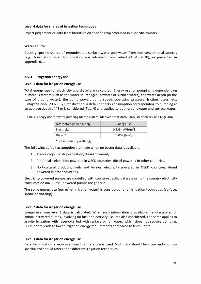
Level 1 data for irrigation energy use
Total energy use for electricity and diesel are calculated. Energy use for pumping is dependent on numerous factors such as the water source (groundwater or surface water), the water depth (in the case of ground water), the pump power, pump speed, operating pressure, friction losses, etc. (Smajstrla et al. 2002). By simplification, a default energy consumption corresponding to pumping at an average depth of 48 m is considered (Tab. 4) and applied to both groundwater and surface water.
Tab. 4: Energy use for water pumping (depth = 48 m) (derived from UofA (2007) in Nemecek and Kägi 2007)
Alternative power supply Energy use
Electricity 0.239 [kWh/m3]
Diesel* 0.059 [l/m3]
*Diesel density = 840 g/l
The following default assumption are made when no better data is available:
1. Arable crops: no drip-‐irrigation, diesel powered,
2. Perennials: electricity powered in OECD countries, diesel powered in other countries,
3. Horticultural products, fruits and berries: electricity powered in OECD countries, diesel powered in other countries.
Electricity-‐powered pumps are modelled with country-‐specific datasets using the country electricity consumption mix. Diesel-‐powered pumps are generic.
The same energy use (per m3 of irrigation water) is considered for all irrigation techniques (surface, sprinkler and drip).
Level 2 data for irrigation energy use Energy use from level 1 data is calculated. When such information is available, hand-‐activated or animal-‐activated pumps, involving no fuel or electricity use, are also considered. The same applies to gravity irrigation with reservoirs fed with surface or rainwater, which does not require pumping. Level 2 data leads to lower irrigation energy requirements compared to level 1 data.
Level 3 data for irrigation energy use Data for irrigation energy use from the literature is used. Such data should be crop-‐ and country-‐specific and should refer to the different irrigation techniques.

30
Level 4 data for irrigation energy use Expert judgement or data from literature relating to level 3 data, per crop and country.
3.5.4 Water emissions
Blue water (i.e. surface water and ground water) balance is achieved in the inventory. For crop production, three output flows are calculated:
§ Water emitted to air = ETirr § Water emitted to surface water = 0.8 * ((ETirr / EFirr) -‐ ETirr) § Water emitted to ground water = 0.2 * ((ETirr / EFirr) -‐ ETirr)
Equations are adapted from Lévová et al. (2012).
3.5.5 Animal production Water use for animal production includes drinking water and cleaning water. Data is taken from the literature or from expert judgement. When no specific data on water withdrawal and release is available, 83% of water use is considered consumed (i.e. 17% is released) (Shaffer 2008). This approach is consistent with the Quantis Water Database (Vionnet et al. 2012).
3.5.6 Food transformation Water use for food transformation includes processing water, cleaning water and cooling water. Data is taken from the literature or from expert judgement. When no specific data on water withdrawal and release is available, 12.2% of water use is considered consumed (i.e. 87.8% is released) (Statistics Canada 2007). This approach is consistent with the Quantis Water Database (Vionnet et al. 2012).
3.6 Fertilisers application
3.6.1 Estimation of nutrient inputs
Nitrogen (kg N), phosphorus (kg P), and potassium (kg K) are taken into account as crop nutrients. If no level 4 or level 3 data are available, the following principles for generic data of level 1 and level 2 are applied:
Level 1 data for nutrient inputs
Nutrient input is calculated based on the nutrient uptake of the crop. For N, the harvested products plus crop residues, such as straw and haulms, are considered, even if the residues might remain on the field. This approach is based on the fact that N contained in the biomass is not readily available for crops, contrary to P and K. Therefore, for P and K only products taken off the field are considered. For N, P and K the calculated nutrient uptake is assumed to be representative of the nutrient content of the crop and crop residues. The same nutrient content values are used for all countries.

31
Level 2 data for nutrient inputs
Correction factors are applied to level 1 data. These take into account national surplus or deficit of fertilisers used. Such correction factors might be based on yield-‐adjusted fertiliser recommendations compared to nutrient uptake (level 1 data) and represent a “national nutrient balance”. The International Fertilizer Association (IFA, www.fertilizer.org) and “Fertilizers Europe” provide statistics about fertiliser and nutrient consumption per country (worldwide) and, in case of Europe, also per crop. For extrapolation the MEXALCA approach is applied (Nemecek et al. 2012; Roches et al. 2010) using crop-‐specific data from an original country and extrapolate it by intensity indices to a target country.
3.6.2 Mineral and organic fertilisers, L1 data
We assume the ratio of N applied as mineral fertilisers to N total (organic and mineral fertilisers) to be 0.8 for all crops and countries (L0). Based on this ratio and the total N applied as fertilisers, the amount of N applied as mineral fertilisers is calculated (crop and country-‐specific data).
In FAOSTAT (2012), the manure N content (kg N in manure) is provided per animal category on a country level (average from 2009-‐2012 was used). Based on these data, the share of liquid and solid manure per animal category and country is calculated, assuming 50% liquid and 50% solid manure for cattle, pigs and laying hens, and 100% solid manure for all other animal categories. In addition, the ratio of N in liquid to N in solid manure per country is calculated from these data.
Nutrient contents of manure (kg Nav/ kg P2O5/ kg K2O per m3 liquid and tonnes solid manure) are provided in Flisch et al. (2009). These contents and the share of liquid and solid manure per animal category are used to calculate the average N, P and K content in liquid and solid manure for a specific country, assuming a dilution level of 50% for liquid manure.
These data allowed to calculate all other fertiliser inputs (crop-‐ and country specific). Solid and liquid manure applied per crop and country is calculated from the total amount of N applied as organic fertilisers, the ratio of N in liquid to N in solid manure per country and the average N content in liquid and solid manure. Based on the average P and K content in liquid and solid manure, P and K applied as organic fertilisers are calculated. Total P and K applied as mineral fertilisers are obtained by taking the difference of total P and K fertilisers calculated via the nutrient content (see above) and P and K from organic fertilisers. Negative values were set to zero, i.e. no mineral fertilisers are applied.
The share of mineral fertiliser types per country are based on statistics provided by IFA (International Fertiliser Association; www.fertilizer.org) for a time period of four years (average of 2009-‐2012), as described in the WFLDB-‐Guidelines V3.0. For Ghana and Vietnam, no country-‐specific data are available, therefore, the world share (L0) is used.
3.6.3 Estimation of mineral fertilisers input
If no level 4 or level 3 data are available, the following principles for generic data of level 1 and level 2 are applied:

32
Level 1 data for shares of mineral fertilisers input
Organic and mineral fertilisers are differentiated. The ratio of organic fertilisers relies on a common source or estimation method applicable to all countries; crop-‐specific data is only applied if available for all crops. FAOSTAT provides national data for the calculation of GHG emissions from animal husbandry. Among others, the manure N content (i.e. quantity of N applied to soil from manure) is provided per animal category. These values serve to calculate the average amount of animal manure applied per area in a country (not crop-‐specific).
The share of mineral fertiliser types per country is based on statistics provided by IFA (International Fertilizer Association, www.fertilizer.org).
Level 2 data for shares of mineral fertilisers input
Crop-‐specific information about organic and mineral fertiliser types per country are used when available. For some crops, specific types of fertilisers are recommended or discouraged. For mineral fertilisers, types used per crop are provided by IFA for European countries. For other countries crop-‐specific information might be obtained from literature or extrapolated from countries with comparable economic situation. For extrapolation the MEXALCA approach is applied (Nemecek et al. 2012; Roches et al. 2010) using crop-‐specific data from an original country, extrapolated by intensity indices to a target country.
3.7 Pesticides application
There are three types of pesticide data with increasing degree of detailing:
1) The total amount of active ingredient (a.i.) from any kind of pesticides
2) The total amount of a.i. used as herbicides, fungicides or insecticides
3) The amount of specific a.i.
By definition, literature or expert data about the amount of specific a.i. used represent L4 data, as these are at a high degree of detail. Literature or expert data about the total amount of a.i. used as herbicides, fungicides or insecticides as well as the total amount of a.i. from any kind of pesticide represent L3 data, owing to a lower degree of detail.
If no level 4 or level 3 data are available, the following principles for generic data of level 1 and level 2 are applied:
Level 1 data for pesticides input
The total amount of active ingredients (a.i.) used per hectare for a specific crop in a specific country are estimated applying the MEXALCA approach (Nemecek et al. 2012; Roches et al. 2010) that uses crop yield and intensity indices per country for pesticide use based on FAOSTAT data. A modified6 formula is used as follows:
6 The ratio of the yield in the target country to the yield in the original country is omitted, because there is no linear relationship between yield and the amount of pesticides applied.

33
𝑋!! = 𝑋!!𝑖𝑛𝑑!!
𝑖𝑛𝑑!!
𝑋!!: Amount of active ingredient in the target country (kg ha-‐1 year-‐1) 𝑋!!: Amount of active ingredient in the original country (kg ha-‐1 year-‐1) 𝑖𝑛𝑑!!: Agricultural index in the target country for the intensity of use of input X (-‐) 𝑖𝑛𝑑!!: Agricultural index in the original country for the intensity of use of input X (-‐)
If no pesticide data is available for the target crop from a different country, the modified MEXALCA approach is applied with a different (but similar) crop than the target crop (e.g. apple for pesticide application in pear -‐ L0 data).
As background dataset, the ecoinvent process “pesticide unspecified” is used, unless more specific information is available. The basic assumption for associating the total A.I. per country (FAOSTAT) to A.I. per hectare is that pesticides are applied to arable land and permanent crops, but not to grassland (where pesticides are rarely used). This is a simplification as the pesticide use varies widely between crops. In general horticultural crops are treated more intensively than arable crops.
Level 2 data for pesticides input
The amount of input per pesticide group (e.g. herbicides, insecticides, fungicides) used per crop and country is extrapolated from an existing dataset for a comparable country regarding agronomic and economic conditions. For the extrapolation the MEXALCA approach is applied (Nemecek et al. 2012; Roches et al. 2010) that uses yield and pesticide intensity indices. The degree of confidence of this extrapolation is documented, according to the data level that is used for the original country. The number of passes for pesticide application is estimated based on a similar extrapolation procedure. As background dataset for pesticides, “herbicide unspecified”, “insecticide unspecified”, and “fungicide unspecified” are used, when specific information is not available.
3.8 Packaging
The following principles are applied: • Packaging for fertilisers: standard package for dry fertilisers is included, i.e. 0.002 kg of
HDPE per kg dry fertiliser; mass of 1 plastic bag for 50 kg solid fertiliser is 0.100 kg (measured data); assumption: 0.5 kg plant nutrients per kg dry fertiliser. .
• Packaging for pesticides: standard package for liquid pesticides is included • Packaging for round bales at farm: included • Packaging for food products: excluded, unless specifically mentioned (e.g. mineral water)
Both the packaging material manufacturing and the packaging forming are included.

34
3.9 Direct emissions from crop and animal production
Direct field and farm emissions are substances emitted from an agricultural area or directly at the farm. Indirect emissions denote emissions that occur in the upstream processes, such as purchased inputs used in agriculture or transports. Direct emissions strongly depend on the site characteristics and are influenced by farm management practices. Indirect emissions are generally modelled with existing life cycle inventories, while specific models are generally used for direct emissions.
Emissions related to energy use such as fuels burnt at the farm are modelled similarly to indirect emissions for practical reasons.
3.9.1 Emissions included
For the agricultural phase the following direct emissions are modelled (using categories defined in the ecoinvent quality guidelines Weidema et al., 2013): Emissions to air (non-‐urban air or from high stacks): Ammonia (NH3) Dinitrogen monoxide or nitrous oxide (N2O) Nitrogen oxides (NOx) Methane, biogenic (CH4) Carbon dioxide, biogenic Carbon dioxide, fossil Carbon dioxide, from land transformation Pesticides (if any applied) Emissions to surface water: Phosphorus, surface water (P from erosion) Phosphate, surface water (PO4
3-‐ from run-‐off) Heavy metals: Cadmium (Cd), Chromium (Cr), Copper (Cu), Lead (Pb), Mercury (Hg), Nickel (Ni) and
Zinc (Zn) Emissions to groundwater: Nitrate (NO3
-‐) Phosphate (PO4
3-‐) Heavy metals: Cadmium (Cd), Chromium (Cr), Copper (Cu), Lead (Pb), Mercury (Hg), Nickel (Ni) and
Zinc (Zn) Emissions to agricultural soil: Heavy metals: Cadmium (Cd), Chromium (Cr), Copper (Cu), Lead (Pb), Mercury (Hg), Nickel (Ni) and
Zinc (Zn)

35
Pesticides (if any applied)7 Further substances can be added, if relevant and if reliable data are available.
3.9.2 Overview of emission models
Tab. 5 gives an overview of the emission models that are used.
Emission models of similar level of detail and quality can be used in later updates of the database.
Tab. 5: Overview of the emission models used in the WFLDB and comparison to other databases.
Emission WFLDB ecoinvent V3.0 AGRIBALYSE
Ammonia (NH3) EMEP (EEA 2013) Tier 2
Agrammon (Tier 3 methodology for CH)
EMEP (EEA 2009) Tier 2
Nitrous oxide (N2O) IPCC (2006) crops: Tier 1
animals: Tier 2
IPCC (2006) crops: Tier 1
animals: Tier 2
IPCC (2006) crops: Tier 1
animals: Tier 2 Nitrate (NO3
-) SALCA-Nitrate (Europe)
SQCB (other countries)
SALCA-Nitrate (Europe)
SQCB (overseas)
Arvalis method (Tailleur et al. 2012)
Phosphorus (P, PO43-) SALCA-P
(Prasuhn 2006) SALCA-P
(Prasuhn 2006) SALCA-P
(Prasuhn 2006)
Heavy metals (Cd, Cr, Cu, Hg, Ni, Pb, Zn)
Freiermuth (2006) (SALCA method)
Freiermuth (2006) (SALCA method)
Freiermuth (2006) (SALCA method)
Methane (CH4) IPCC (2006) Tier 2
IPCC (2006) Tier 2
IPCC (2006) Tier 2
3.9.3 Ammonia (NH3)
Several methods are available for the estimation of NH3 emissions. The most widespread basis are the EMEP/EAA guidelines from the European Environment Agency, which are used to establish national emission inventories. The latest update of the methodology has been published in August 2013. The same methodology is also used in the AGRIBALYSE database (Colomb et al. 2014), with the difference that in AGRIBALYSE emission factors are taken from the EMEP/CORINAIR guidelines 2006 (EEA 2006), which represent a simplified approach. The ecoinvent V3.0 uses the Swiss Agrammon model, which is similar, but more detailed especially in the area of emissions from animal husbandry. The Agrammon model is a Tier-‐3 methodology for Switzerland and provides a number of correction factors, which can be used to represent specific situations. In the international context of the WFLDB, the EMEP/EAA guidelines are followed.
The emission factors for mineral fertiliser are taken from the EMEP guidelines 2013 (EEA 2013).
7 The modelling of pesticide emissions fractions emitted to the environment is matter of a current scientific debate (workshops in Glasgow in May 2013, Basel in May 2014 and Bordeaux in August 2015). It is the WFLDB intention to follow the global consensus that may result from this international effort (Rosenbaum et al. 2015).

36
Tab. 6: Emission factors for NH3 after the application of mineral N fertiliser (EEA, 2013, 3.D Table 3-‐2) in function of the soil pH.
Fertilizer type (m)
EMEP/EEA 2013 EFa
kg N/kg N Soil pH<=7
EFb kg N/kg N Soil pH>7
Ammonium sulphate (AS) 0.011 0.222
Ammonium nitrate (AN) 0.030 0.030
Calcium ammonium nitrate (CAN) 0.018 0.018
Anhydrous ammonia 0.009 0.009
Urea 0.200 0.200
Urea ammonium nitrate (UAN) 0.103 0.103
Di-ammonium phosphate (DAP) 0.093 0.241
Mono-ammonium phosphate (MAP) 0.093 0.241
Other complex NK, NPK fertiliser 0.030 0.030
Urea ammonium sulphate (UAS) 0.161 0.161
The emission is calculated as follows:
NH3 = 17/14 * 𝐸𝐹𝑎! ∗ 𝑝 + 𝐸𝐹𝑏! ∗ 1 − 𝑝 ∗ 𝑁!"#!!!!
where
NH3 = ammonia emission after mineral fertiliser application [kg NH3]
m = fertiliser type (M = number of fertiliser types)
EFam = emission factor on soils with pH<=7 [kg NH3-‐N/kg N] (see Tab. 6)
EFbm = emission factor on soils with pH>7 [kg NH3-‐N/kg N] (see Tab. 6)
p = fraction of soils with pH <= 7 [%/100]
Nmin = mineral fertiliser application [kg N]
The emission factors for animal housing, yard, manure storage, manure spreading and grazing are taken from the EMEP/EEA guidelines 2013, which have in fact not changed since the guidelines from 2009.

37
Tab. 7: Emission factors for NH3 related to animal production (from EEA, 2013, 3.B Table 3.7, other sources given in footnotes) for liquid and solid manure storage. The emission factors (EF) refer to the TAN (total
available nitrogen) content of the manure at each stage (kg NH3-‐N/kg TAN).
Livestock Housing period
Nexcreted
Pro- portion of TAN
Manure storage
type
EF housing
EF yard
EF storage
EF spreading
EF grazing/ outdoor
Unit d a-1 kg
head-1 a-1
kg TAN kg N-1 kg NH3-N kg TAN-1
Dairy cows 180 105 0.6 liquid 0.20 0.30 0.20 0.55 0.10 180 105 0.6 solid 0.19 0.30 0.27 0.79 0.10
Other cattle (young cattle, beef cattle and suckling
cows)
180 41 0.6 liquid 0.20 0.53 0.20 0.55 0.06
180 41 0.6 solid 0.19 0.53 0.27 0.79 0.06
Fattening pigs (8–110 kg) 365 12.1 0.7 liquid 0.28 0.53 0.14 0.40 0.253 365 12.1 0.7 solid 0.27 0.53 0.45 0.81 0.253
Sows (and piglets to 8 kg) 365 34.5 0.7 liquid 0.22 0.534 0.14 0.29 0.25 365 34.5 0.7 solid 0.25 0.534 0.45 0.81 0.25
Sheep (and goats) 30 15.5 0.5 solid 0.22 0.75 0.28 0.90 0.09 Horses (and mules, asses) 180 47.5 0.6 solid 0.22 0.351 0.35 0.90 0.35
Laying hens (laying hens and parents),
365 0.77 0.7 solid 0.41 0.701 0.14 0.69 0.092 365 0.77 0.7 liquid 0.41 0.701 0.14 0.69 0.092
Broilers (broilers and parents) 365 0.36 0.7 solid 0.28 0.701 0.17 0.66 0.092
Other poultry (turkeys) 365 1.64 0.7 solid 0.35 0.701 0.24 0.54 0.092 Other poultry (ducks) 365 1.26 0.7 solid 0.24 0.701 0.24 0.54 0.092 Other poultry (geese) 365 0.55 0.7 solid 0.57 0.701 0.16 0.45 0.092
Average (from Agri-BALYSE) 2
liquid 0.25 0.48 0.16 0.51 0.09
solid 0.28 0.48 0.28 0.71 0.09 1 Values taken from Agrammon 2 Average values from AGRIBALYSE 3 Same values as for sows 4 Same values as for fattening pigs
The default housing periods and amount of N excreted should be used only, if no specific data are available. More specific default values for N excretion rates per 1000 kg of body weight and day can be found in IPCC (2006, Table 10.19).
During manure storage, losses of N2 occur. The corresponding emission factors are 0.003 kg N2/kg TAN for liquid and 0.3 kg N2/kg TAN for solid manure (EEA, 2013, 3.B Tab. 3.8). Although N2 emissions are not directly relevant from an environmental point of view, they have to be considered, in order to achieve a correct N balance. N lost in form of N2 is no more available for further processes.
The amounts of N added in straw are added to the amount of total N in solid manure for litter-‐based systems. Default values are available in EEA (2013, 3.B Tab. 3.5)
Furthermore, the immobilization of N in solid manure and the mineralisation of N in liquid manure are calculated. The corresponding rates are (EEA, 2013):
§ Immobilization of 0.0067 kg N/kg TAN for solid manure is calculated after the subtraction of the losses during manure storage and
§ Mineralisation of fmin = 0.1 kg/kg for solid manure, calculated as (Ntotal-‐TAN)*fmin before the calculation of the N emissions.

38
The values for N excretion will be taken from national sources or calculated from the feed intake. The standard emission factors will be used in datasets, representing an average situation of a country.
Agrammon (HAFL 2013) provides numerous correction factors for specific situations. In particular these are:
§ N excretion: milk yield, feed ration, phase feeding § Emissions from housing: type of floor, air cleaning (pigs and poultry), drinking water supply
system (poultry), manure system (poultry) § Yard: type of floor, season § Manure storage: cover of manure stores (for solid and liquid manure), slurry mixing, § Manure spreading: spreading technique, weather during spreading, season of spreading § Pasture/grazing: duration of grazing
These correction factors should be applied to represent situations deviated from the average.
The conversion factor from N to NH3 is 17/14.
3.9.4 Nitrogen oxides (NOx, NO, NO2)
Nitrogen oxides stem mainly from the nitrification process. The importance of NOx emissions from N fertiliser and manure management is relatively small compared to other sources. Therefore simple emission factors are used: Emission factor for the application of mineral and organic fertiliser (including animal manure
§ 0.012 kg NOx-‐N/kg N applied (EEA, 2013, 3.D Tab. 3-‐1, converted from NO to N: 0.026*14/30=0.012)
Emission factor for manure management: § 0.00005 kg NOx-‐N/kg N in liquid manure and § 0.0047 kg NOx-‐N/kg N solid manure (EEA, 2013, 3.D Tab. 3.8, converted from NO to N)
The emission is calculated after subtraction of the N volatilized as NH3.
EEA (2013) expresses the emissions of NOx as NO, while in ecoinvent NOx is calculated as NO2. In order to be compatible with the latter, the emissions will be converted to NO2. The conversion factor from N to NO2 is 46/14.
3.9.5 Nitrous oxide (N2O)
Nitrous oxide (N2O) is produced during nitrification and denitrification processes and is a very powerful greenhouse gas. For nitrous oxide we are following IPCC guidelines (IPCC, 2006) Tier 2 for animal production and Tier 1 for crop production.
3.9.5.1 Crop Production
More detailed models exist for the calculation of emissions from crop production (including application of manure). E.g. Hillier et al. (2011) use in the Cool Farm Tool the regression model of Bouwman et al. (2002), which varies the emission rate in function of the rate of N application, crop type, soil texture, soil organic carbon, soil drainage, soil pH and the climate type. It is an interesting alternative for estimating N2O emissions on field and farm scale. In the context of the WFLDB, national averages are considered. The influencing factors are quite difficult to estimate at national level (only the respective crop area should be considered). This would lead to using default values in

39
most cases. Furthermore it is an exponential equation. This means that using average values for the different factors in the equation will lead to biased results. A calculation for the different subset of conditions would be needed and a weighted average would need to be calculated from the resulting N2O emissions. Given the complexity of this model and the risk of introducing bias, the chosen approach in the WFLDB is to use the IPCC (2006) Tier 1 factors:
N2O = 44/28 * (0.01 (Ntot + Ncr + Nsom + 14/17*NH3 + 14/46*NOx) + 0.0075 * 14/62*NO3)
N2O = emission of N2O [kg N2O ha-‐1]
Ntot = total nitrogen in mineral and organic fertiliser [kg N ha-‐1]
Ncr = nitrogen contained in the crop residues [kg N ha-‐1]
Nsom = nitrogen from mineralisation of soil organic matter [kg N ha-‐1]
NH3 = losses of nitrogen in the form of ammonia [kg NH3 ha-‐1]
NOx = losses of nitrogen in the form of nitrogen oxides [kg NO2 ha-‐1].
NO3 = losses of nitrogen in the form of nitrate [kg NO3 ha-‐1].
N2O released during decomposition of organic matter in the soil after land use change is a further source of emissions.
For flooded rice, the emission factor for direct emissions of N2O is 0.003 (IPCC, 2006, Table 11.1, EF1FR) instead of 0.01.
3.9.5.2 Animal Production
For the animal production, the emission factors from IPCC (2006) Tier 2 are used. In order to be consistent with the calculations of NH3 emissions, which are based on TAN rather than total N, the calculation procedure as proposed by EEA (2013) is followed.

40
Tab. 8: Emission factors for N2O related to animal production (from EEA, 2013, 3.D Table 3.6). The emission factors (EF refer to the TAN content of the manure). NA = factor not relevant for solid manure.
Livestock
Manure
type
N2O - manure storage N2O - pasture
EF kg N2O-N (kg TAN entering store)-1
EF kg N2O-N (kg TAN entering store)-1
EF kg N2O-N (kg TAN entering store)-1
EF kg N2O-N (kg
Nexcreted)-1
Without natural crust
With natural crust
Pit storage below animal confinements
Dairy cows liquid 0.00 0.01 0.00 0.02 solid 0.08 NA NA 0.02
Other cattle (young cattle, beef cattle and suckling cows)
liquid 0.01 0.01 0.00 0.02 solid 0.08 NA NA 0.02
Fattening pigs (8–110 kg) liquid 0.00 0.01 0.00 0.02 solid 0.05 NA NA 0.02
Sows (and piglets to 8 kg) liquid 0.00 0.01 0.00 0.02 solid 0.05 NA NA 0.02
Sheep (and goats) solid 0.07 NA NA 0.01 Horses (and mules, asses) solid 0.08 NA NA 0.01
Laying hens (laying hens and parents)
solid 0.04 NA NA 0.02 liquid 0.00 NA NA 0.02
Broilers (broilers and parents) solid 0.03 NA NA 0.02 Other poultry (turkeys) solid 0.03 NA NA 0.02 Other poultry (ducks) solid 0.03 NA NA 0.02 Other poultry (geese) solid 0.03 NA NA 0.02
The N2O emissions from grazing are calculated as: § 2% of N excreted for cattle (dairy, non-‐dairy and buffalo), poultry and pigs § 1% for sheep and other animals.
For all reactive N emissions (NH3, NO3, NOx) from crop production and animal husbandry induced emissions are calculated. These are called “indirect emissions” in IPCC (2006), but as this term is misleading in the context of LCA, we use the term “induced emissions” instead. The respective emissions factors are:
§ 0.01 kg N2O-‐N/kg NH3-‐N resp. NOx-‐N and § 0.0075 kg N2O-‐N/kg NO3-‐N (IPCC 2006, Table 11.3)
The quantities of NH3, NOx and NO3 calculated in the dataset are used for this calculation and not the much simpler emission factors given by IPCC (2006, Tab. 11.3).
3.9.6 Methane (CH4) emissions
Methane emissions from animal husbandry are calculated by the default methodology from IPCC (2006) Tier 2, which takes into account differences in feeding and production levels.

41
3.9.6.1 CH4 from enteric fermentation
Enteric fermentation: 𝐸𝐹 =!"∗ !!
!"" ∗!"#
!!,!" (Tier 2 method)
EF = CH4 emission [kg CH4/head/year]
GE = gross energy intake [MJ/head/day]
Ym = methane conversion factor [%GE converted to CH4]
55.65 MJ/kg CH4 = energy content of methane
Tab. 9: Methane conversion factors (Ym) for the conversion of energy intake through feed into energy lost as CH4. (IPCC, 2006, Tab. 10.12)
Animal category Ym Source Cattle (except feedlot fed) 6.50% IPCC (2006), Tier 2
Cattle (feedlot fed) 3.0% IPCC (2006), Tier 2 Pigs 0.60% FOEN (2013)
Sheep (and goats) 6.50% IPCC (2006), Tier 2 Horses 2.50% FOEN (2013) Poultry 0.16% FOEN (2013)
IPCC (2006) suggests applying Tier 2 emission factors only for cattle and sheep and Tier 1 factors for all other impact categories. For consistency reasons, we use Tier 2 factors for all animal categories, which are taken from the Swiss National Inventory report (FOEN, 2013).
When no better data is available, the GE intake can be estimated from DM intake, by using the default value of 18.45 MJ/kg DM from IPCC (2006).
3.9.6.2 CH4 from manure management and grazing
𝐸𝐹(!) = 𝑉𝑆(!) ∗ 365 ∗ 𝐵!(!) ∗ 0.67𝑘𝑔 𝑚! ∗𝑀𝐶𝐹!,!100
∗𝑀𝑆(!,!,!)!,!
EF(T) = annual CH4 emission factor for livestock category T [kg CH4 animal-‐1 yr-‐1]
VS(T) = daily volatile solid excreted for livestock category T [kg dry matter animal-‐1 day-‐1]
365 = basis for calculating annual VS production [days yr-‐1]
B0(T) = maximum methane producing capacity for manure produced by livestock category T, [m3 CH4 kg-‐1 of VS excreted]
0.67 = conversion factor of m3 CH4 to kilograms CH4
MCF(S,k) = methane conversion factors for each manure management system S by climate region k [%] (see Tab. 11
MS(T,S,k) = fraction of livestock category T's manure handled using manure management system S in climate region k [dimensionless]
𝑉𝑆 = 𝐺𝐸 ∗ 1 −𝐷𝐸%100
+ 𝑈𝐸 ∗ 𝐺𝐸 ∗1 − 𝐴𝑆𝐻18,45
VS = volatile solid excretion per day on a dry-‐organic matter basis [kg VS day-‐1]

42
GE = gross energy intake [MJ day-‐1]
DE% = digestibility of the feed in percent (e.g. 60%)
(UE • GE) = urinary energy expressed as fraction of GE. Typically 0.04GE can be considered urinary energy excretion by most ruminants (reduce to 0.02 for ruminants fed with 85% or more grain in the diet or for swine). Use country-‐specific values where available.
ASH = the ash content of manure calculated as a fraction of the dry matter feed intake (e.g., 0.08 for cattle). Use country-‐specific values where available.
18.45 = conversion factor for dietary GE per kg of dry matter (MJ kg-‐1). This value is relatively constant across a wide range of forage and grain-‐based feeds commonly consumed by livestock.
Tab. 10: Maximum methane producing capacities for manure produced by livestock category.
Animal category Bo(T) (m3 CH4/kg VS excreted) Other cattle 0.18
Beef fattening 0.18 Dairy cows 0.24 Dairy goat 0.18
Dairy sheep 0.19 Lamb < 1 year 0.19
Turkey 0.36 Pigs 0.45
Broilers (chicken) 0.36 Laying hens 0.39
Tab. 11: Methane conversion factors for each manure management system for the cool climate, temperate and warm climates. Factors for warmer climates can be found in IPCC (2006, Tab. 10.17). Source: IPCC (2006,
Tab. 10.17, for anaerobic digestion Umweltbundesamt (2013, p. 288))
Categories IPCC (2006) MCF Cool (<15°C)
MCF Temperate (15-25°C)
MCF warm (>25°C)
Pasture/Range/Paddock/Dry lot 1.0% 1.5% 2.0%
Solid storage 2.0% 4.0% 5.0%
Liquid with natural crust cover1 10.0% 26.0% 48.0%
Liquid without natural crust cover1 20.0% 42.0% 78.0%
Uncovered anaerobic lagoon1 70.0% 78.0% 80.0%
Pit storage below animal confinements >1months1 20.0% 42.0% 78.0%
Anaerobic digester 2.0% 2.0% 2.0% Cattle and swine deep bedding >1months1 20.0% 42.0% 78.0%
Composting (static pile) 0.5% 0.5% 0.5%
Poultry manure 1.5% 1.5% 1.5%
1 More detailed MCF factors are given in IPCC (2006, Tab. 10.12). The medium values of each class are used here, i.e. the value for the following temperatures: 12°C for cool, 20°C for temperate and 27°C for warm climate.
3.9.6.3 CH4 from rice cultivation
CH4 emissions during rice cultivation are calculated according to IPCC (2006). The default baseline emission factor for non-‐flooded rice fields is 1.3 kg CH4 ha-‐1 d-‐1 (IPCC 2006, Tab. 5.11). This value is then adjusted according to the water regime during rice cultivation (IPCC 2006, Tab. 5.12), the water regime before rice cultivation (IPCC 2006, Tab. 5.13), and to organic amendments (IPCC 2006, Tab. 5.14).

43
The specific assumptions regarding the emission factors for the two producing countries considered in the database are as follows:
Tab. 12: Assumptions for the calculation of CH4 emissions from rice cultivation
China India Scaling factor to account for the water regime during the cultivation period (SFw)
0.6 (single aeration) 0.78 (unknown)
Scaling factor to account for the water regime before the cultivation period (SFp)
1 (non-‐flooded pre-‐season < 180 days)
1.22 (unknown)
Scaling factor to account for the type and amount of organic amendment applied (SFO)
1 (no organic amendments)
1.16 (2 t ha-‐1 manure (L3 data))
Duration of cultivation period 91 days (2 crop cycles per year)
153 days (1 crop cycle per year)
Information regarding specific soil types is not available. Based on these scaling factors and the baseline emission factor, adjusted daily emission factors are calculated using equation 5.2 (IPCC 2006). These adjusted daily emission factors and the cultivation period are used in equation 5.1 (IPCC 2006) to calculate the annual methane emissions, which are 71 kg and 219 kg in China and India, respectively. The lower amount of methane emitted from rice grown in China result from more specific data for this country as well as the fact that only one crop cycle is considered instead of one year. Rice in China is produced twice a year, whereas in India there is only one crop cycle per year.
3.9.7 Nitrate leaching to ground water
Depending on the country of crop production, different models were used to calculate nitrate leaching. A model by Richner et al. (2014) specifically for the application to conditions in Switzerland (SALCA-‐NO3) is applied for Europe. This model allows for a relatively detailed assessment of the processes during the cropping cycle. For non-‐European countries, the SQCB-‐NO3 model, a geographically unspecific and simpler model, is used (de Willigen 2000, in: Faist Emmenegger et al. 2009).
Gaseous losses of NH3, NOx and N2O are subtracted from the amount of N applied in the fertilisers prior to the calculation of nitrate leaching.
3.9.7.1 The SALCA-‐NO3 model
Geographic scope of application: Europe
The model SALCA-‐NO3 calculates the expected nitrate leaching and comprises the following elements (Richner et al., 2014):
§ Nitrogen mineralisation from the soil organic matter per month § Nitrogen uptake by vegetation (if any) per month § Nitrogen input from the spreading of fertiliser § Soil depth
Factors not considered: § Amount of seepage § Denitrification

44
The model of Richner et al. (2014) calculates the expected nitrate leaching of arable crops, meadows and pasture land considering crop rotation, soil cultivation, N fertilization but also N mineralisation from the soil organic matter, N uptake by the plants and various soil conditions. The calculation is based on the monthly difference between the amount of mineralised N in the soil and the N uptake by the plants. Furthermore, the nitrate leaching risk from fertiliser application varies in function of the time of N application. The expected nitrate leaching of pastures rises because of locally high nitrate concentrations. Therefore the total amount of nitrate on pastures is calculated from the number of animals, the grazing duration and the grazing period.
The total expected nitrate leaching of an arable crop is assessed by the sum of the monthly values within the assessment period starting one month after the harvest of the former crop and ending in the month of harvesting of the given crop.
Tab. 13: Expected nitrogen mineralisation (Nmin m, kg N per ha and month, from Richer et al. 2014) in soils with 15% clay, 2% humus and N input from farm manure of 1 livestock unit (LU)/ha in the valley region. Intensive soil cultivation means treatment by a rotary cultivator or a rotary harrow in the respective month. In months
where there is no intensive soil cultivation, the values “Without intensive soil cultivation” are used.
Jan. Feb. March Apr. May June July Aug. Sept. Oct. Nov. Dec. Without intensive soil cultivation 0 0 6 9 12 15 17 21 23 12 6 0
With intensive soil cultivation 0 0 10 15 20 25 29 38 38 20 10 0
N mineralisation is further corrected for clay and humus content of the soil (Tab. 14) as well as for green manuring and tillage of pastures (see Richner et al. 2014).
Tab. 14: Correction factors of nitrate mineralisation (%) for the clay and humus content of the soil.
Humus content (%) <3 3-5 5-8 8-15
Clay content
(%)
0-20 0 +10% +20% +40%
20-30 -10% -5% +5% +25%
30-40 -20% -20% -10% +5%
>40 -30% -30% -25% -15%
N uptake by vegetation was estimated based on the model STICS (Brisson et al. 2003) with a high temporal resolution (100 time steps from sowing to physiological maturity of the crop in question). These N uptake functions were determined for the crops grass, protein peas, barley, potatoes, maize, rapeseed, soy beans, sunflower, wheat and sugar beets assuming for each crop a standard yield and a corresponding standard nitrogen uptake as given in Flisch et al. (2009). Nitrogen uptake by other crops is approximated by these functions or by combinations of them (see Richner et al. 2014). Variations in nitrogen uptake due to yields deviating from the standard yield were accounted for by scaling the nitrogen uptake relative to the difference between standard and real yields.
The N mineralisation from soil organic matter is further corrected for the average stocking rate, in order to reflect the conditions in farms with livestock. The basic values of nitrogen mineralisation which refer to 1 livestock unit (LU)/ha linearly decrease or increase with the stocking rate by 10% per 1 LU/ha.
The risk of nitrate leaching due to fertiliser application is dependent on the crop and the month in which fertiliser was applied (Tab. 15; Richner et al. 2014). The amount of N in mineral form (100% for the mineral fertilisers and varying percentages for the organic fertilisers) is the basis of the calculation. From this, the gaseous losses in form of NH3, NOx and N2O are subtracted. The contents

45
of mineral (soluble) N in organic fertilisers can be taken from Tab. 7 or from national sources like Flisch et al. (2009).
Tab. 15: Risk of nitrogen leaching (fraction of potentially leachable nitrogen of the N applied through fertilisers in %, from Richner et al. 2014).
Months Winter cereals Maize, soya
beans
Winter rape seed and green
manure
Potato, sugar and
fodder beets
Fava beans, protein peas
(spring sown)
Sun-flowers
Perma-nent
meadow Int
Perma-nent
meadow Ext
sowing year
harvest- year
harvest- year
sowing year
harvest- year
harvest- year
harvest- year harvest- year
calendar year
calendar year
January 100 50 100 100 20 100 100 100 20 20 February 100 30 100 100 10 100 100 100 10 20
March 100 10 100 100 0 50 50 50 0 0 April 100 0 80 100 0 30 30 30 0 0 May 100 0 70 100 0 10 0 0 0 0 June 100 0 0 100 0 0 0 0 0 0 July 100 - 0 100 - 0 0 0 0 0
August 100 - 0 80 - 0 - 0 0 0 September 90 - 0 0 - 0 - - 0 0
October 90 - - 0 - - - - 0 0 November 90 - - 20 - - - - 10 20 December 90 - - 20 - - - - 20 20
The correction of the expected nitrate leaching due to fertiliser application for the depth of the soil is listed in Tab. 16. The loss rates can be up to 100%, when N is applied in periods when no N uptake takes place.
Tab. 16: The correction of the expected nitrate leaching due to fertiliser application in function of the depth of soil (Richner et al. 2014).
Soil depth (cm) Correction (%) > 100 0
91-100 +5 81-90 +10 71-80 +15 61-70 +20 51-60 +25 41-50 +30 ≤ 40 +35
Generally no seepage occurs during the intensive vegetation period because the evapotranspiration is similar or higher than the precipitation. Therefore usually no nitrate leaching occurs during this period. For various crops fertilisation is only possible shortly before the growing period due to agronomic or technical reasons. The model accumulates the monthly values of N mineralisation, nitrate uptake by the plants and the nitrate from fertilisation during this period (Tab. 17). Values exceeding 100% are set to 100%.

46
Tab. 17: Accumulation of the monthly values of nitrate mineralisation, nitrate uptake by the plants and the nitrate from fertilising for various crops (Richner et al. 2014). The grey cells show the periods during which the values of N mineralisation, N fertilisation and N uptake are added and the leaching risk is calculated from the
sum of these values. In the white cells, the calculation is performed on a monthly basis.
Crop Month
J F M A M J J A S O N D Winter cereal Spring cereal
Maize, soybean Potato
Sugar beet, fodder beet Sunflower
Fava bean, protein pea (spring sown) Fava bean, protein pea (autumn sown)
Permanent meadow
As nitrate leaching is strongly dependent on the availability of water percolating the top soil which, in turn, depends on the precipitation, a correction factor is introduced. This ‘nitrate leaching transformation factor represents the ratio of winter precipitations (October to March8) of the region in question and the site of Reckenholz (Switzerland, site of model calibration, where the average precipitation October-‐March is 433 mm) as most leaching occurs in this period. The results of SALCA-‐NO3 are multiplied by the respective transformation factor.
3.9.7.2 The SQCB-‐NO3 model
The SQCB-‐NO3 model is reported in Faist Emmenegger et al. (2009) and is an adaption of a formula developed by de Willigen (2000) and used and validated by Roy et al. (2003). The formula calculates the leaching of NO3-‐N and is a simple regression model of the form:
[ ]UNSLcPN org *00362.0*0000601.0*0037.0*
37.21 −++=
where:
N = leached NO3-‐N [kg N/(ha*year)]
P = precipitation + irrigation [mm/year]
c = clay content [%]
L = rooting depth [m]
S = nitrogen supply through fertiliser [kg N/ha]
Norg = nitrogen in organic matter [kg N/ha]
U = nitrogen uptake by crop [kg N/ha]
8 Since the model is applied only to Europe, the Southern hemisphere does not need to be considered.

47
The SQCB model provides relatively simple approaches to assess most of the required input parameters. P and Corg are determined through the ecozone in which the crop is produced. The ecozones for the whole globe are defined and presented as maps in FAO (2001). Fix values for carbon content in the upper 30 cm of soil and for annual precipitation are assigned to each ecozone (see Tab. 18). More specific values can be used, where available. The carbon content in tonnes per 3000 m3 (1 ha [area] * 30 cm [depth]) is converted into mass fraction by the formula:
Corg [%] = Corg [t/3000 m3] * (1 / 1.3 t m-‐3) * 100
In case of irrigation, the amount of irrigation water [mm] is added to the precipitation in order to obtain the parameter P. The amount of irrigation water is calculated according to section 3.5.2.
Where several ecozones are covered by the considered crop producing region, the model is applied to each ecozone and an average nitrate leaching rate for the whole producing region is calculated from the ecozone-‐wide results, weighted by the contribution of each ecozone to crop production – in terms of harvested acreage or production volume according to data availability.
Tab. 18: FAO ecozones and their assigned carbon content and annual precipitation. Due to high variability in precipitation, no values are given for montane ecozones. For these ecozones precipitation values have to be
researched in each individual case. (From Faist Emmenegger et al. 2009)
FAO ecozones Carbon content [t C/ha in upper 30cm= t/3000 m3]
Annual precipitation [mm]
Tropical wet 59 2500 Tropical moist 48 1500 Tropical dry 34 1000 Tropical dry 34 500 Tropical dry 34 50
Tropical montane 55 - Warm temperate moist 55 1200 Warm temperate dry 25 700 Warm temperate dry 25 400 Warm pemperate dry 25 200
Warm temperate moist or dry 40 - Cool temperate moist 81 1500 Cool temperate moist 81 600 Cool temperate dry 38 300 Cool temperate dry 38 150
Cool temperate moist or dry 59 - Boreal moist 22 500 Boreal dry 22 400
Boreal moist and dry 22 -
The clay content c is defined by the USDA soil order of a producing region or its sub-‐unit, respectively. A constant value for clay content is assigned to each USDA soil order based on USDA (1999) (see Tab. 19). The maps for defining sub-‐units of production regions or ecozones by soil orders are taken from USDA (1999), as well, and more detailed maps especially for the USA from the USDA website (http://soils.usda.gov/technical/classification/orders/).

48
Tab. 19: USDA soil orders and their assigned clay contents. (From Faist Emmenegger et al. 2009)
USDA soil order clay content [%] Alfisol 28.0
Andisol 10.4 Aridisol 17.2 Entisol 3.5 Gelisol 23.7 Histosol 2.0
Inceptisol 4.9 Mollisol 21.1 Oxisol 53.9
Spodosol 1.8 Ultisol 12.3
Vertisol 49.0
The rooting depth for several crops is given in the SQCB report by Faist Emmenegger (2009). The missing values were taken from other literature. Values and sources are presented in Tab. 20.
Tab. 20: Crops and their rooting depth as assumed for calculations.
Crop Rooting depth [m] Source Potatoes 0.5 FAO 2011
Sugar cane 1.6 FAO 2011 Sweet sorghum 1.5 FAO 2011
Rape seed 0.9 SQCB report Soybeans 0.95 FAO 2011 Oil palm 1.0 SQCB report Wheat 1.2 FAO 2011 Maize 1.35 FAO 2011 Rice 0.6 Mishra et al. 1997
Cotton 1.35 FAO 2011
The nitrogen supply S is calculated from the total N application of mineral fertilisers and of soluble N in organic fertilisers after subtraction of the gaseous losses in form of NH3, NOx and N2O. The original model sources (de Willigen, 2000; Roy et al. 2003) do not make a clear distinction between mineral and organic fertilisers. Since only the mineral (soluble) form of N is prone to leaching and for reasons of consistency with the SALCA-‐NO3 model, only the soluble part of N in organic fertilisers is counted.
The nitrogen uptake U can be taken from Faist Emmenegger et al. (2009) or other sources (e.g. Flisch et al., 2009). Linear adjustments must be made for different yields. In the case of legumes, only 40% of the values given in the SQCB report are considered as N uptake in order to reflect the fact, that the remaining 60% are fixed from the air and are not directly relevant to the balance of nitrogen supplied through fertilisers and mineralised from the soil organic matter (Schmid et al. 2000).
To calculate the organic nitrogen Norg in soil [kg N/ha] from the soil organic carbon content Corg [%] the following quantities are needed:
• soil volume V [m3/ha]
V is taken to be 5000 m3, which means that the upper 50 cm of soil are considered (according to pers. comm. J. Leifeld, ART, 2011), assuming the same carbon content for 30-‐50 cm depth as calculated above for 0-‐30 cm depth.
• bulk density Db [kg/m3]

49
Bulk density is taken to be 1300 kg/m3, which is the standard value from the SQCB report.
• C/N ratio rC/N [dimensionless]
The C/N ratio is taken to be 11. This is the mean value of the range (10-‐12) determined through literature research (Batjes 2008; Scheffer 2002; Eggleston et al. 2006) and consultation of experts (pers. comm. J. Leitfeld, Agroscope).
• ratio of Norg to Ntot (total soil nitrogen) rNorg [dimensionless]
The C/N ratio expresses the ratio of Corg and Ntot. The ratio rNorg is needed calculate Norg from
Ntot, which is calculated in a first step applying the C/N ratio. rNorg is assumed to be 0.85 (Scheffer 2002).
• Norg is calculated by the formula:
𝑁!"# = 𝐶𝑜𝑟𝑔100
×𝑉 ×𝐷! ÷ 𝑟!/! × 𝑟!"#$
Norg is the mass of organic nitrogen contained in the upper 50 cm of soil. Naturally only a fraction of this mass is mineralised and, hence, available for uptake by plants and leaching to the ground water. This fraction is determined by the mineralisation rate, which is 1.6% here and implicitly included in the regression coefficient (0.0000601) of the term Norg.
3.9.8 Phosphorus emissions to water
Three different paths of phosphorus emissions to water are distinguished:
§ leaching of soluble phosphate (PO4) to ground water (inventoried as “phosphate, to ground water”),
§ run-‐off of soluble phosphate to surface water (inventoried as “phosphate, to surface water”),
§ water erosion of soil particles containing phosphorus (inventoried as “phosphorus, to surface water”).
Erosion by wind is not considered in these guidelines. However, in cases where wind erosion is important, it should be taken into account.
The emission models SALCA-‐P (Prasuhn 2006) developed by Agroscope are applied. The following factors are considered for the calculation of P emissions:
§ type of land use
§ type of fertiliser
§ quantity of P in fertiliser
§ type and duration of soil cover for the calculation of the soil erosion (C-‐factor).
For other factors, considered in the model SALCA-‐P, default values are used (Prasuhn 2006):
§ distance to next river or lake
§ topography
§ chemical and physical soil properties
§ drainage.

50
The model takes soil erosion, surface run-‐off and drainage losses to surface water and leaching to ground water into account.
The key factors of the model are listed below.
3.9.8.1 Phosphate leaching to ground water
P leaching to the ground water was estimated as an average leaching, corrected by P-‐fertilization:
Pgw = Pgwl * Fgw
Pgw = quantity of P leached to ground water [kg/(ha*a)]
Pgwl = average quantity of P leached to ground water for a land use category [kg/(ha*a)], which is: 0.07 kg P/(ha*a) for arable land and 0.06 kg P/(ha*a) for permanent pastures and meadows.
Fgw = correction factor for fertilization by slurry [dimensionless]
Fgw = 1 + 0.2/80*P2O5sl
P2O5sl = quantity of P2O5 contained in the slurry or liquid sewage sludge [kg/ha]. The values of P2O5-‐content were taken from Flisch et al. (2009) or other national sources.
3.9.8.2 Phosphate run-‐off to surface water
Run-‐off to surface water was calculated in a similar way to leaching to ground water:
Pro = Prol * Fro
Pro = quantity of P lost through run-‐off to rivers [kg/(ha*a)]
Prol = average quantity of P lost through run-‐off for a land use category [kg/(ha*a)], which is 0.175 kg P/(ha*a) for arable land, 0.25 kg P/(ha*a) for intensive permanent pastures and meadows and 0.15 kg P/(ha*a) for extensive permanent pastures and meadows
Fro = correction factor for fertilization with P [dimensionless], calculated as:
Fro = 1 + 0.2/80 * P2O5min + 0.7/80 * P2O5sl + 0.4/80 * P2O5man
P2O5min = quantity of P2O5 contained in mineral fertiliser [kg/ha] P2O5sl = quantity of P2O5 contained in slurry or liquid sewage sludge [kg/ha] P2O5man = quantity of P2O5 contained in solid manure [kg/ha]
The values of P2O5-‐content for slurry and manure were taken from Flisch et al. (2009) or other national sources.
3.9.8.3 Phosphorus emissions through water erosion to surface water
P emissions through erosion of particulate phosphorous to surface water were calculated as follows:
Per = Ser * Pcs * Fr * Ferw
Per = quantity of P emitted through erosion to rivers [kg P/(ha*a)]
Ser = quantity of soil eroded [kg/(ha*a)]
Pcs = P content in the top soil [kg P/kg soil]. The average value of 0.00095 kg/kg was used.

51
Fr = enrichment factor for P (-‐). The average value of 1.86 was used (Wilke & Schaub 1996). This factor takes account of the fact that the eroded soil particles contain more P than the average soil.
Ferw = fraction of the eroded soil that reaches the river [dimensionless]. The average value of 0.2 was used.
The amount of eroded soil Ser is calculated using the universal soil loss equation as described in Faist Emmenegger et al. (2009), where the USLE (Universal Soil Loss Equation, Wischmeier and Smith 1978) is expressed as: Ser = 1000 * R * k * LS * c1 * c2 * P
where Ser = Potential long term annual soil loss [kg ha-‐1 yr-‐1] R = Erosivity factor [MJ mm ha-‐1 h-‐1 yr-‐1] k = Erodibility factor [t h MJ-‐1 mm-‐1] LS = Slope factor [-‐] c1 = Crop factor [-‐] c2= Tillage factor [-‐] P = Practice factor [-‐]
The erosivity factor is computed according to Renard and Freimund (1994):
Where: R is the erosivity factor [MJ*mm/ha/yr] P is precipitation factor [mm/yr] calculated as P = precipitation*(1-‐FracSnow)+0.1*(irrigation+FracSnow*precipitation) Where FracSnow is the fraction of the annual precipitation falling as snow [%/100]. This is an adaptation of the formula used in Faist Emmenegger et al. (2009), distinguishing between summer and winter type precipitation patterns.
The LS factor computation is based on the original equation described in Wischmeier and Smith (1978). The only adjustment consists in transforming the input data from the SI (International System of Units) units to the American metric system. Indeed this formula requires length in feet whereas the user types it in in meters.
Where Si is the slope of the segment i expressed in %, Li is the length of the segment i expressed in meters and LSi is the partial slope factor for the segment i. The factor 3.28083 is a conversion factor from meter to feet and 100 is a conversion factor related to the fact that the slope is expressed in %.
⎩⎨⎧
>+−
≤=
mmPifPPmmPifP
R850*004105.0*219.18.587850*0483.0
2
61.1
⎪⎪⎪⎪⎪
⎩
⎪⎪⎪⎪⎪
⎨
⎧
>++⎟⎠
⎞⎜⎝
⎛
≤≤++⎟⎠
⎞⎜⎝
⎛
<≤++⎟⎠
⎞⎜⎝
⎛
<++⎟⎠
⎞⎜⎝
⎛
=
5%Sif)065.0))100
(sin(*56.4))100
(sin(*41.65(*72.63.28083*L
%5%5.3)065.0))100
(sin(*56.4))100
(sin(*41.65(*72.63.28083*L
%5.3%1)065.0))100
(sin(*56.4))100
(sin(*41.65(*72.63.28083*L
%1)065.0))100
(sin(*56.4))100
(sin(*41.65(*72.63.28083*L
i2
0.5i
20.4
i
20.3
i
20.2
i
ii
iii
iii
iii
i
SS
SifSS
SifSS
SifSS
LS

52
LS is then computed as the sum of all LSi: Where n is the number of segments. In the WFLDB, only one segment will be considered as default. The K factor is calculated either from the Table 7-‐2 given by Faist Emmenegger et al. (2009) or taken from Table 5 in Panagos et al. (2014) for European countries and Table 4 for other countries, where the information about the soil class is not available (only the clay and sand content needed). The c1 factor is taken from Table 7-‐3, c2 the factor from 7-‐4 and the P factor from Table 7-‐5 in Faist Emmenegger et al. (2009) or from other literature.
3.9.9 Heavy metals emissions to agricultural soil, surface water and ground water
According to an analysis of the heavy metals9 that are causing problems in agriculture (Kühnholz 2001), the following seven were selected:
§ Cadmium (Cd)
§ Chromium (Cr)
§ Copper (Cu)
§ Lead (Pb)
§ Mercury (Hg)
§ Nickel (Ni)
§ Zinc (Zn)
No distinction is made between CrII and CrIII, only the sum of Cr flows is considered.
Typical heavy-‐metal content of agricultural and non-‐agricultural soils is given by Desaules & Dahinden (2000). Kühnholz (2001) gives a comparison of different emission factors and methods for calculating heavy metal balances.
The heavy metal emissions are calculated by SALCA-‐heavy metal (Freiermuth 2006). Inputs into farm land and outputs to surface water and groundwater are calculated on the basis of heavy metal input from seed, fertiliser, plant protection products and deposition from the air. Crop residues left on the field are not considered, since they do not leave the system. Average heavy metal contents for arable land, pastures, meadows and horticultural crops are used to calculate the amounts of heavy metals exported by soil erosion. The amount of eroded soil is the same as calculated for the P-‐emissions (see above). An allocation factor is used to distinguish between diffuse and agriculture-‐related introduction (Freiermuth 2006).
Three types of emissions are considered:
§ Leaching of heavy metals to the ground water (always positive values)
9 Heavy metals are metals with a specific weight greater than 5 g/cm3 (Source: http://chemistry.about.com/od/chemistryglossary/g/Heavy-‐Metal-‐Definition.htm).
∑=
=n
iiLSLS
1

53
§ Emissions of heavy metals into surface waters through erosion of soil particles (always positive values)
§ Emissions of heavy metals to agricultural soil (positive or negative values according to the results of the balance).
The following sources are used to calculate heavy-‐metal contents:
§ Mineral fertiliser: Desaules & Studer (1993, p. 153), see Tab. 25,
§ Farmyard manure: Menzi & Kessler (1998) and Desaules & Studer (1993, p. 152), see Tab. 26,
§ pesticides: FOAG (2014),
§ biomass (seed and products from plant production): Houba & Uittenbogaard (1994, 1995, 1996 & 1997), von Steiger & Baccini (1990) and Wolfensberger & Dinkel (1997); Bennett et al. (2000) & for Nickel Teherani (1987) for rice; generic mean of biomass for cotton due to lack of data with mass allocation to fibre and seed (Freiermuth 2006); see Tab. 24.
Heavy metal emissions into ground and surface water (in case of drainage) are calculated with constant leaching rates as:
Mleach i = mleach i * A i
Mleach i agricultural related heavy metal i emission
mleach i average amount of heavy metal emission (Tab. 21)
A i allocation factor for the share of agricultural inputs in the total inputs for heavy metal i
Tab. 21: Heavy metal leaching to groundwater according to Wolfensberger & Dinkel (1997).
Leaching Cd Cu Zn Pb Ni Cr Hg mg/ha/year 50 3600 33000 600 n.a. 21200 1.3
Heavy metal emissions through erosion are calculated as follows:
Merosion i = ctot i * Ser * a *ferosion * A i
Merosion agricultural related heavy metal emissions through erosion [kg ha-‐1 a-‐1]
ctot i total heavy metal content in the soil (Keller & Desaules 2001, see Tab. 22 [kg/kg])
Ser amount of soil erosion (see section 3.9.8.3) [kg ha-‐1 a-‐1]
a accumulation factor 1.86 (according to Wilke & Schaub (1986) for P) [-‐]
ferosion erosion factor considering the distance to river or lakes with an average value of 0.2 (considers only the fraction of the soil that reaches the water body, the rest is deposited in the field) [dimensionless]
A i allocation factor for the share of agricultural inputs in the total inputs for heavy metal i [dimensionless]

54
Tab. 22: Average heavy metal contents in mg per kg soil for Switzerland (from Keller & Desaules, 2001).
Land use Cd [mg/kg]
Cu [mg/kg]
Zn [mg/kg]
Pb [mg/kg]
Ni [mg/kg]
Cr [mg/kg]
Hg [mg/kg]
Permanent grassland 0.309 18.3 64.6 24.6 22.3 24.0 0.088 Arable land 0.24 20.1 49.6 19.5 23.0 24.1 0.073
Horticultural crops 0.307 39.2 70.1 24.9 24.8 27.0 0.077
The original values for Switzerland are used as default (Tab. 21).
The balance of all inputs into the soil (fertilisers, pesticides, seed and deposition) and outputs from the soil (exported biomass, leaching and erosion), multiplied by the allocation factor is calculated as an emission to agricultural soil.
Msoil i = (Σ inputsi -‐ Σ outputsi) * A i
If the uptake of heavy metals by plants and the emissions from leaching and erosion exceed the inputs, a negative balance will result. This happens in particular if a large biomass is harvested and the inputs are low. The heavy metals are transferred to the biomass and have to be appropriately considered in the subsequent life cycle modelling (i.e. returned to the soil, transferred to the water or to landfills at the end of the life cycle).
A certain fraction of the heavy metal input into the soil stems from atmospheric deposition. The deposition would occur even without any agricultural production and is therefore not charged to the latter. An allocation factor accounts for this. The farmer is therefore responsible for a part of the inputs only (the rest stems mainly from other economic sectors), therefore only a part of the emissions is calculated in the inventory.
A i = Magro i / (Magro i + Mdeposition i)
A i allocation factor for the share of agricultural inputs in the total inputs for heavy metal i
Magro i total input of heavy metal from agricultural production in mg/(ha*year) (fertiliser + seeds + pesticides)
Mdeposition i total input of heavy metal from atmospheric deposition in mg/(ha*year) (Tab. 23)
In cases, where Magro i = 0, i.e. no agricultural inputs to the soil occur, Ai also becomes 0.
Tab. 23: Heavy metal deposition (see Freiermuth 2006).
Cd Cu Zn Pb Ni Cr Hg
Deposition [mg/ha/year] 700 2400 90400 18700 5475 3650 50

55
Tab. 24: Heavy-‐metal contents of plant material (mg/kg dry matter, from Freiermuth 2006).
Element Cd Cu Zn Pb Ni Cr Hg Unit [mg/kg DM]
Generic mean 0.10 6.6 32.0 0.54 1.04 0.55 0.04 Grass / Hay 0.13 8.6 40 1.2 1.68 1.09 0.15 Maize grains 0.03 2.5 21.5 0.3 1.16 0.32 0 Maize silage 0.1 5 34.5 1.61 0.48 0.7 0.01 Wheat grains 0.1 3.3 21.1 0.2 0.2 0.2 0.01 Wheat straw 0.2 2.5 9.6 0.6 0.6 0.7 NA Barley grains 0.03 4.3 26.6 0.2 0.1 0.1 NA Barley straw 0.1 4.8 11.1 0.6 0.8 1.2 NA Rye straw 0.1 3.2 13 0.4 0.7 0.5 NA Potatoes 0.04 6.45 15 0.55 0.33 0.57 0.09
Rape seed 1.6 3.3 48 5.25 2.6 0.5 0.1 Faba beans 0.04 6 30.1 0.87 1.3 0.69 0 Soya beans 0.06 15.1 47.7 0.08 5.32 0.52 0 Protein peas 0.09 10 73 0.16 0.83 0.32 0.01 Sugar beets 0.4 12 36.4 1.16 1.08 1.775 0.095 Rice grains 0.02 5.27 43.9 0.96 0.97 0.49 NA
Tab. 25: Heavy-‐metal contents of mineral fertilisers [mg/kg nutrient] according to Desaules & Studer (1993). No data available on Hg. Source: Freiermuth (2006).
Mineral fertilisers (%N/%P2O5/%K2O/%Mg)
Cd Cu Zn Pb Ni Cr
[mg/kg nutrient]
[mg/kg nutrient]
[mg/kg nutrient]
[mg/kg nutrient]
[mg/kg nutrient]
[mg/kg nutrient]
Urea (46/0/0) kg N 0.11 13.04 95.65 2.39 4.35 4.35 Calcium ammonium nitrate (20/0/0)
kg N 0.25 60.00 155.00 5.50 90.00 10.00 Ammonium nitrate (27.5/0/0) kg N 0.18 25.45 181.82 6.91 47.27 14.55 Ammonium sulphate (21/0/0) kg N 0.24 19.05 142.86 5.24 8.57 9.52 Calcium ammonium nitrate (27/0/0)
kg N 0.19 8.52 100.00 5.93 12.59 2.96 Magnesium ammonium nitrate
(23/0/0/5) kg N 0.43 56.52 4.35 4.35 21.74 6.09 Generic mean N 0.21 22.25 121.43 5.37 17.17 7.81
Triple superphosphate (0/46/0) kg P2O5 113.04 97.83 650.00 7.61 95.65 567.39
Superphosphate (0/19/0) kg P2O5 52.63 121.05 852.63 578.95 105.26 342.11 Thomas meal (0/16/0) kg P2O5 1.56 250.00 425.00 75.00 125.00 12212.50 Hyperphosphate/raw phosphate
(0/26/0) kg P2O5 50.00 115.38 915.38 23.85 76.92 611.54 Generic mean P 51.32 118.22 751.32 49.42 100.46 589.46
Potassium chloride (KCl) (0/0/60) kg K2O 0.10 8.33 76.67 9.17 3.50 3.33
Potassium sulphate (0/0/50) kg K2O 0.10 4.00 64.00 6.60 1.60 4.00 Raw potassium (0/0/26/5) kg K2O 0.19 173.08 153.85 11.54 11.54 173.08
Lime kg CaO 0.12 4.00 8.00 3.60 12.20 314.00 Generic mean K 0.11 6.17 70.33 7.88 7.52 88.54

56
Tab. 26: Heavy-‐metal contents of farmyard manure and organic fertiliser (mg/kg DM, compiled by Freiermuth 2006 from from Menzi & Kessler (1998) and Desaules & Studer (1993, p. 152)). Dry matter (DM) contents from
Walther et al. (2001, Tab. 44).
Farmyard manure Cd Cu Zn Pb Ni Cr Hg DM-content
Cattle liquid manure 0.18 37.1 162.2 3.77 4.3 3.9 0.4 9.0% Cattle slurry 0.16 19.1 123.3 2.92 3.1 2.1 0.6 7.5%
Cattle staple manure 0.17 23.9 117.7 3.77 4.3 3.9 0.4 19.0% Cattle manure form loose housing 0.15 22.0 91.1 2.81 4.3 3.9 0.4 21.0%
Pig liquid manure 0.21 115.3 746.5 1.76 8.6 6.7 0.8 5.0% Pig solid manure 0.21 115.3 746.5 1.76 8.6 6.7 0.8 27.0%
Litter from broilers 0.29 43.8 349.2 2.92 40.0 10.0 0.2 65.0% Litter from belts from laying hens 0.25 39.6 468.4 2.24 7.9 5.5 0.2 30.0%
Litter from deep pits from laying hens 0.25 39.6 468.4 2.24 7.9 5.5 0.2 45.0%
In some cases, the users want to exclude heavy metal uptake by the biomass from the total heavy metal flows. This can e.g. be the case if an incomplete life cycle is modelled. For this purpose the uptake by the crops is modelled in separate inventories (separated from the inputs). These datasets are called “product, uptake” (e.g. “wheat grains, uptake”). The heavy metal uptake is included as negative emissions into agricultural soil. A switch parameter “heavy_metal_uptake” is introduced allowing exclusion of heavy metal uptake in such situations.
3.9.10 Carbon dioxide (CO2) emissions after urea or lime applications
After application of urea and lime, fossil CO2 is released to the air. The worst-‐case approach according to IPCC (2006) is followed, so that the total amount of C is considered as released to the air is the form of CO2.
For urea, the emission is 1.57 kg CO2/kg Urea-‐N10.
For limestone (CaCO3) and dolomite ((Ca Mg)CO3) the following emission factors apply:
§ 12/100 * 44/12 = 0.44 kg CO2/kg limestone
§ 12/92.2 * 44/12 = 0.48 kg CO2/kg dolomite.
3.9.11 Pesticide emissions
The amount of different active ingredients is determined as described in section 3.7. This section describes the modelling of the pesticide emissions in the crop inventories.
In the ecoinvent database, pesticide emissions are modelled as 100% of the substance emitted to agricultural soil. This rule is followed in the first and second release of the WFLDB.
For the 3rd release (which will ultimately be submitted to ecoinvent), the rules defined in the workshops on 11 May 2013 in Glasgow (Rosenbaum et al., submitted) and 10 May 2014 in Basel will be followed. The latter’s outputs will lead to providing and publishing default emission fractions.
10 The molecular weight of urea (CH4N2O) is 60, the C content is 12/60, the N content is 28/60, the conversion of C into CO2 is 44/12, from which follows: 12/60*60/28*44/12=1.57.

57
These default values will be used in the WFLDB, unless more appropriate values are available. The results of the Basel workshop could lead to a revision of the inventory modelling of pesticides.
The following information should be included in the documentation: § Pesticide identification (CAS registry numbers and names of active ingredients per applied
plant protection product, PPP); § Application method (foliar spray, soil injection, drip irrigation) and formulation type (soluble
concentrate, granule, wettable powder); § Presence of buffer zones (y/n); § Application time in days before harvest (for human health impacts) and crop growth stage
(for terrestrial/aerial ecosystem impacts) during application.
The active ingredients applied are distributed among the different environmental media (“emission fractions”), which correspond to the initial distribution after the application according to the definition of the workshop in Basel on 10 May 2014. The following fractions will be distinguished:
– On-‐field: • soil surface (excluding plant deposit) à agricultural soil; • paddy water (excluding plant deposit), e.g. for paddy rice à surface water; • plant (plant deposit) à this amount is reported in the documentation, but excluded
from the inventory, since no plant compartment exists at the moment in the database;
– Off-‐field: • air (via volatilization on-‐field and wind drift, fraction not deposited close to the field); • surface water (via spray drift deposition, excluding runoff, avoiding double counting
with air (of which a fraction eventually redeposits on surface water at long distance); distinguishing fresh and marine water as far as possible and meaningful;
• soil (distinguishing types [natural, industrial, agricultural, etc.] if possible).
The emission fractions to environmental media via initial distribution and the degraded fraction sum up to 100% of the quantity applied to the field in order to maintain conservation of mass and to allow for assessment of all potential impacts in the LCIA.
3.10 Carbon uptake by plants
Carbon is taken up in the form of carbon dioxide and fixed in the biomass. The carbon dioxide uptake by the growing crops is considered a resource input, which is important for the assessment of the climate change impact.
It is calculated from the carbon content of the products, which in turn can be calculated from the carbohydrate, protein, fat, fibre, and ash composition of the harvested products and the carbon contents (Nemecek & Kägi 2007, Tab. 21). The CO2 uptake by the plant is estimated by multiplying the carbon content in the plant dry matter by the stoichiometric factor 44/12. Data on the composition of different products can be found e.g. in the USDA National Nutrient Database (http://ndb.nal.usda.gov/), Feedipedia (http://www.feedipedia.org/) or in the Swiss feed database (http://www.feed-‐alp.admin.ch). If no composition information is available, 47.5% is taken as default value for carbon content of dry mass (http://www.fao.org/forestry/17111/en/). If other sources than the above-‐mentioned are used, this will be described in the dataset-‐specific documentation. Carbon bound in crop residues that remain on the field is not considered as residues are decomposed and carbon is thus released.

58
The net release of biogenic CO2 from biomass is included as ‘Carbon dioxide, biogenic’. Only net changes of biomass stocks are considered, i.e. if the C stock in the biomass changes between the beginning and the end of the inventory period (typically a growing season).
Tab. 27: Carbon contents of different fractions of the biomass
Fraction C-content (g/kg dry mass)
Source
Carbohydrates 440 Rouwenhorst et al. (1991) Proteins 530 Rouwenhorst et al. (1991) Lipids 750 Nemecek & Kägi (2007) Fibres 440 Nemecek & Kägi (2007) Ash 0 Nemecek & Kägi (2007)
3.11 Crop production activities
3.11.1 Machinery for field operations
If no level 4 or level 3 data are available, the following principles for generic data of level 1 and level 2 are applied:
Level 1 data for machinery use of field operations
Relates to data about the total machinery input per hectare for a specific crop and country but not referring to specific field activities. As background dataset, the ecoinvent process “Agricultural machinery, general (kg)” is used. The machinery input is estimated according to the MEXALCA approach (Nemecek et al. 2012; Roches et al. 2010) by using the machinery input according to the intensity index for machinery use in a given country (based on FAOSTAT data). In addition, for application of fertilisers, pesticides and for irrigation the machinery use is related to the yield of a specific crop, based on the assumption that higher yield is associated with higher machinery input. In contrast, soil cultivation, sowing and harvesting are assumed to be non-‐correlated to the yield.
Level 2 data for machinery use of field operations
Such data are specific to field operations (e.g. soil cultivation, sowing, application of fertiliser and pesticide, harvesting). Here also, the MEXALCA approach (Nemecek et al. 2012; Roches et al. 2010) is applied. In order to consider the increase for soil cultivation with increased portion of clay in the soil, the Cranfield model (Williams et al. 2006) is applied. The Cranfield model can be applied for cereals, soya, maize (grain and forage) and field beans under agronomic and economic conditions similar to England. Soil conditions for other countries are taken from the SQCB tool (Faist Emmenegger et al. 2009). The portion of no-‐till for each country is estimated according to Derpsch and Friedrich (2009).
Machinery types (non exhaustive list):
Soil cultivation
• Soil tillage, plough (ha)
• Soil tillage, chisel (ha)
• Soil tillage, spring-‐tine weeder (ha)

59
• Soil tillage, rotary harrow (ha)
• Soil tillage, spring-‐tine harrow (ha)
• Soil tillage, hoeing and earthing up, potatoes (ha)
• Soil tillage, roll (ha)
• Soil tillage, rotary cultivator (ha)
Sowing, planting
• Sowing (ha)
• Planting (ha)
• Potato planting (ha)
Fertilisation
• Fertilizing, by broadcaster (ha)
Plant protection
• Application of pesticides, by field sprayer (ha)
Harvesting
• Combine harvesting (ha)
• Chopping maize (ha)
• Fodder loading by self-‐loading trailer (m3)
• Harvesting beets by complete harvester (ha)
• Harvesting potatoes by complete harvester (ha)
• Haying by rotary tedder (ha)
• Loading bales (unit)
• Mowing by motor mower (ha)
• Mowing by rotary mower (ha)
• Potato grading (kg)
• Potato haulm cutting (ha)
• Swath by rotary windrower (ha)
Irrigation facility
• Surface irrigation, with gravity irrigation and flood irrigation being special cases of surface irrigation.
• Sprinkler irrigation, or spray irrigation
• Drip irrigation, or micro-‐irrigation
The ecoinvent database provides infrastructure data for sprinkler irrigation. This includes a mobile sprinkler system; with fix installed pump, 100 m water pipe and hydrant, turbine propulsion, 300 m water hose, automaton, shed, excavation (100 m3 soil/ha) and tractor operation (with diesel consumption of 3.78 kg/ha) (Nemecek and Kägi 2007).
For surface irrigation, the ecoinvent sprinkler irrigation infrastructure is adapted as follows:

60
• Tractor operation is doubled
• Excavation is doubled
• Diesel use for tractor operation and excavation is doubled
• Water hoses are removed
For drip irrigation, data from Torrellas et al. (2012) is used.
3.11.2 Drying
Level 1 data for drying inputs
The MEXALCA approach (Nemecek et al. 2012; Roches et al. 2010) is used to estimate the inputs for grain and forage drying. This model considers that drying is proportional to the yield (crop-‐specific) and the drying indices (country-‐specific).
Level 2 data for drying inputs
Level 2 data are based on country-‐specific literature for specific crops, when available. Substantial differences to level 1 data shall be documented and explained.
3.12 Animal production activities
Included process for animal fattening systems at farm:
• Young animal purchase for fattening or milking
• Stable (including infrastructure)
• Direct emissions from animals and manure storage to air
Not included: Emission from manure spreading, because these are part of crop and feed production processes
• Feed (roughage, concentrate feed, pasture)
• Feed storage facility
• Transport (mainly for feed from storehouse to the farm)
• Water
• Energy carriers and machinery used for husbandry
Fattening systems for cattle, swine and chicken at farm:
Only intensive, non-‐grazing production systems are modelled based on concentrated feed. Typical for intensive systems is a relative short fattening period and relative low total feed consumption compared to less intensive systems or grazing systems.
Critical parameters for animal production are the intensity of the production and the organisation of the system, feeding, housing, manure management, and the proportion of grazing.
The intensity of the system can be described by the milk yield per cow and per year for dairy systems. For meat production, the daily body weight gain is a key parameter, which can be

61
calculated from the initial and final weights, as well as the duration of fattening/growth. For milk and meat production the feed conversion ratio, i.e. the amount of feed consumed per kg of milk or meat, is a good indicator to roughly assess the environmental impacts of the production.
For beef production, two different systems are distinguished: 1) suckler cow systems and 2) combined dairy and beef production. In suckler cow systems, the calf consumes all the milk and therefore all impacts of the suckler cows are allocated to the beef production. In combined dairy and beef production, both milk and beef are produced and therefore an allocation between these two products is applied.
For milk production, the following parameters are used to define typical production systems:
• Herd size (large, medium, small, micro)
• Grazing vs. non-‐grazing
• Mechanised vs. non-‐mechanised
For eggs production one intensive system is defined where laying hens are kept in barn, single tiered but not in battery cage.
3.12.1 Animal feed production
In general, feedstuffs represent a major share of the environmental impacts of animal production systems. The number of different feedstuffs used can be considerable as well as their sourcing. Therefore great care must be taken to select the most suitable inventories. For the modelling, the following priorities apply:
1. When the requested feedstuff inventory is available for the investigated country, it shall be used.
2. When the requested feedstuff inventory is available for another country or higher geographical area, the country with most similar conditions shall be chosen.
3. When requested feedstuff inventory is not available, a feedstuff with a similar production route (e.g. rapeseed meal for sunflower meal) or with similar function (energy rich feed, protein rich feed) shall be modelled.
4. If a feedstuff represents more than 30% of the total ration and no satisfactory data are available, a specific inventory shall be created, if possible.
Where detailed data on feeding are lacking, the total energy intake in feed can be estimated by the methodology described by IPCC (2006).
Feedlot systems are distinguished, since different emission factor for methane apply to these (section 3.9.6.1).
3.12.2 Housing, manure management and grazing
In addition to feeding, the housing and manure management systems as well as the proportion of feed taken up on pastures are critical parameters. Ideally, data representative of the entire country or modelled system should be used. Where such information is not available, the most frequent (“typical”) system shall be modelled.
For dairy systems, six different manure management systems are considered:
• Daily spread

62
• Dry lot
• Lagoon
• Liquid/Slurry
• Pit storage
• Solid storage
Emission factors from IPCC (2006) are used for three average climate conditions:
• Cool (<15°C)
• Temperate (15 to 25°C)
• Warm (>25°C)
Emissions to air that are accounted for: CH4, NH3, N2O (direct and indirect) and NOx
Emissions to groundwater: NO3-‐
The share of manure management systems in different countries (Tab. 28) is taken from FAO (2010), Table 2.4 "Average manure storage systems and the average percentage of nitrogen leaching from manure storage systems in the ten FAO regions":
Tab. 28: Shares of manure management systems for dairy cattle in different regions
3.12.3 Slaughtering
Included process at slaughterhouse:
• Transport of animal from farm to slaughterhouse (200 km assumed)
• Slaughterhouse
o energy carriers
o tap water
o packaging film

63
o chemicals: acid and alkaline foam cleaning agents, and disinfectant
o slaughterhouse and infrastructure
o Waste treatment (e.g. sewage, disposal bio-‐waste)
• Multi-‐output dataset: several co-‐products from slaughtering considered; economic allocation is applied (see section 2.6.4)
3.13 Food transformation activities
3.13.1 General principles
Several food processing activities are modelled in the WFLDB, including:
• Dairy products manufacturing
• Oil extractions
• Coffee processing
• Cocoa processing and chocolate manufacturing
• Bread and pasta manufacturing
• Margarine production
• Tomato processing
Data for such activities are taken from the literature (empirical studies or technical data) and crosschecked by sectorial experts whenever possible. They are either representative of average global practices or specific to a given country. The data source, technology and calculations are provided in the documentation of each dataset.
3.13.2 Home cooking
Major variations in home cooking practices are observed among individuals and cultures. The datasets developed within the WFLDB cannot aim to cover all possible cooking modes but focus on those most commonly seen in western countries: baking, frying, boiling, steaming and microwaving.
For frying, boiling and (unpressurized) steaming, different energy sources for stoves are assessed: electricity, natural gas and liquefied petroleum gas (LPG). Datasets include parameters in such a way that cooking time, microwave power and volume of boiling water can be customized.
Modelling is based equations from Sonesson (2003) and Milà i Canals et al. (2008), as well as technical data on cooking appliances.
3.14 Electricity
The national consumption electricity mix (including imports) is used for national datasets. ecoinvent data are used to model electricity production and transmission. When not available, data from the International Energy Agency is used (IEA 2011) to create specific national production mixes and electricity at grid (high, medium and low voltage) datasets.

64
3.15 Infrastructure
Agricultural infrastructure and equipment are allocated to the production datasets according to Nemecek & Kägi (2007). The general rule is:
Ip = Itot/PVtot
Ip = amount of infrastructure/equipment allocated to one unit of product p.
Itot = total amount of infrastructure/equipment
PVtot = total production of product p over the lifetime of infrastructure/equipment I.
3.16 End-‐of-‐life activities
3.16.1 Waste treatment
As typical cradle-‐to-‐gate or gate-‐to-‐gate datasets, the end of life of the products themselves modelled in the WFLDB is not addressed. The so-‐called cut-‐off allocation approach is applied to waste generated in the different production or transformation activities, in a way that is consistent with ecoinvent. Final treatment – landfilling or incineration – of waste is allocated to the product system. Waste fractions that are reused in a different product system or that are recycled into new marketable materials are fully allocated to other product systems. These flows are therefore modelled in the inventory, but no treatment activity is accounted for.
The cut-‐off approach makes it easy for users to adapt the datasets with a different end-‐of-‐life allocation rule, such as the 50/50 approach, the 0/100 approach, the 100/0 approach, or any market-‐based approach. WFLDB datasets published through the ecoinvent database may also have different allocation rules for waste flows (e.g. allocation at the point of substitution).
The end-‐of-‐life of packaging materials, auxiliary materials and infrastructure that are not converted to the modelled product are included.
3.16.2 Wastewater treatment
Wastewater treatment plants (WWTP) in ecoinvent are classified in five capacity classes. WWTP capacities are expressed in per-‐capita equivalents [PCE]. Class 1 is the largest infrastructure (over 100000 PCE/year) while class 5 is the smallest (30-‐2000 PCE/year) (Doka 2007).
When the activity takes place in a rural area, class 4 (2000-‐10000 PCE/year) is used by default. When the activity takes place in an urban area, class 2 (50000-‐100000 PCE/year) is used by default.
In situations where it can be reasonably assumed that no WWT facility is available, water outflows are considered released in the environment. Known and quantified pollutants are accounted for as emissions to surface water.

65
4 Data quality
4.1 Dataset documentation
The documentation structure is consistent with requirements of ecoinvent version 3.0 (Weidema et al. 2013) that distinguishes between specific information inherent to a given dataset and information valid for several datasets documented in a separate document (Figure 7).
Figure 7: Documentation structure related to data collection and modelling
Data Collection Tool
SALCA Modelcalulating direct emissions on the
field
SimaPro
Documentation specific for one datasetinherent to the dataset
-‐ General information (activity description, modelling, administrative)-‐ Flow specific information (exchanges, uncertainty, data quality)
Documentation valid for several datasets
Helps to get a quick information on datasets of the same product independent from a LCA software.-‐ Modelling, data sources-‐ Overview of input data per country of one product
farm
non-‐farm activities

66
4.2 Data quality assessment
Two levels of data quality assessment are assessed.
4.2.1 Data quality at dataset level
The European Commission Product Environmental Footprint (PEF) data quality assessment is applied. According to the PEF Guide (EU-‐JRC 2010a; p.329) the following six criteria for quality assessment of LCI data shall be used:
1. Technological representativeness (TeR)
2. Geographical representativeness (GR)
3. Time-‐related representativeness (TiR)
4. Completeness (C)
5. Precision / uncertainty (P)
6. Methodological appropriateness and consistency (M).
Each criterion is rated on the scale presented in Tab. 29:
Tab. 29: ILCD data quality rating scale (EU-‐JRC 2010a; p. 331)
Rating Definition
1 Very good
2 Good
3 Fair
4 Poor
5 Very poor
Additional options, not being quality levels
5 Not evaluated or unknown
0 Not applicable
The overall data quality rating (DQR) is calculated by summing up the achieved quality rating for each of the quality criteria, divided by the total number of criteria, i.e. the arithmetic mean. The calculated DQR is then qualified as:
§ Excellent quality: 𝐷𝑄𝑅 ≤ 1.6
§ Very good quality: 1.6 < 𝐷𝑄𝑅 ≤ 2.0
§ Good quality: 2.0 < 𝐷𝑄𝑅 ≤ 3.0
§ Fair quality: 3.0 < 𝐷𝑄𝑅 ≤ 4.0
§ Poor quality: 𝐷𝑄𝑅 > 4.0

67
4.2.2 Data quality at flow level
At flow level the quality is expressed as the uncertainty related to its amount, which enables to conduct Monte Carlo simulation. To estimate the uncertainty the “ecoinvent pedigree approach” as defined in ecoinvent version 2 report No. 1 (Frischknecht et al., 2007)11 is applied. The flow uncertainty is calculated from the “basic uncertainty” and the estimated variance of the “underlying normal distribution”.
The underlying normal distribution is characterised by a standard deviation calculated based on the 5 quality scores from the “pedigree matrix”. This matrix lists 5 indicators, i.e. reliability, completeness, temporal correlation, geographical correlation, and further technological correlation, as detailed in Tab. 30.
11 This may be adapted in future version of the WFLDB, with ecoinvent version 3 report No. 1 (Weidema et al. 2013; pp. 70-‐77)

68
Tab. 30: Pedigree matrix used to define indicator scores for data categories (Weidema et al. 2013; p. 76)
Score 1 2 3 4 5 (default)
Reliability Verified data based un
measurements
Verified data partly based on assumptions
OR non-‐verified data based on measurements
Non-‐verified data partly based on qualified estimates
Qualified estimates (e.g. by industrial
expert)
Non-‐qualified estimate
Completeness
Representative data from all sites relevant for the market considered over an adequate
period to even out normal fluctuations
Representative data from >50% of the sites market considered over an adequate
period to even out normal fluctuations
Representative data from only some sites
(<50%) relevant for the market considered OR >50% of the sites but from shorter periods
Representative data from only
one site relevant for the
market considered OR some sites but from shorter
periods
Representativeness unknown or data from a small
number of sites AND from shorter
periods
Temporal correlation
Less than 3 years of
difference to the time period of the dataset
Less than 6 years of
difference to the time period of the dataset
Less than 10 years of
difference to the time period of the dataset
Less than 15 years of
difference to the time period of the dataset
Age of data unknown OR more
than 15 years difference to the time period of the
dataset
Geographical correlation
Data from area under study
Average data from larger area in which the area under
study is included
Data from area with similar production conditions
Data from area with slightly
similar production conditions
Data from unknown OR
distinctly different area (e.g. Europe instead of North-‐
America)
Further technological correlation
Data from enterprises, processes and materials
under study
Data from processes and materials
under study (e.g. identical technology) but from different
enterprises
Data from processes and materials
under study but from different technology
Data on related processes or materials
Data on related processes on
laboratory scale OR from different technology
To ensure consistency throughout the database and to keep the workload for estimating the uncertainties in a feasible range, the scores for data categories are defined as can be taken from Tab. 31.

69
Tab. 31: Assumed scores per data category for pedigree matrix indicators
Data category Indicator scores "Comment field" of the process
Reliability
Com
pleten
ess
Tem
poral correlatio
n
Geo
grap
hical correlatio
n Further te
chno
logical
xcorrelatio
n
Sam
ple siz
e
Seed quantity 2 1 1 1 1 na (2,1,1,1,1,na)
Fertiliser quantity and fertiliser application 2 1 1 1 1 na (2,1,1,1,1,na)
Pesticide quantity and pesticide application
2 2 1 1 1 na (2,2,1,1,1,na)
Other machinery usage, grain drying, land use
2 1 1 1 1 na (2,1,1,1,1,na)
Transports 4 1 1 1 1 na (4,1,1,1,1,na)
Direct field emissions 2 2 1 1 1 na (2,2,1,1,1,na)
Irrigation water 2 1 1 1 1 na (2,1,1,1,1,na)
4.3 Quality control procedure
The quality control procedure described below applies to all datasets developed within the WFLDB:
1. Technical control – focus on calculations: a technical expert of Quantis or Agroscope verifies that calculations and assumptions are correct and aligned with the WLFDB modelling guidelines.
2. Technical control – focus on modelling choices: a technical expert from Quantis or Agroscope verifies which elementary flows and background datasets were used, checks their relevance and consistency among datasets.
3. Metadata control: Quantis and Agroscope verify that datasets are fully documented and that all metadata is properly recorded.
4. Internal quality control: a scientific expert of Quantis and a scientific expert of Agroscope control that datasets are consistently modelled, are aligned with the WFLDB guidelines, and fulfil overall quality standards of the WFLDB.
5. External third-‐party validation: a panel of third party experts in LCA of agro-‐food verify that datasets correspond to ecoinvent standards and validate their integration in the ecoinvent database. The same third party can also validate data quality for their integration in the European Life Cycle Data Network.

70
5 References
Batjes N.H. (2008) ISRIC-‐WISE Harmonized Global Soil Profile Dataset (Ver. 3.1). Report 2008/02, ISRIC – World Soil Information, Wageningen (with dataset). Available at: http://www.isric.org/isric/webdocs/docs//ISRIC_Report_2008_02.pdf?q=isric/webdocs/Docs/ISRIC_Report_2008_02.pdf.
Bauen A., Chudziak C., Vad K. & Watson P. (2010) A causal descriptive approach to modelling the GHG emissions associated with the indirect land use impacts of biofuels. E4tech, London, UK
Bennett J.P., Chiriboga, E., Colemann, J. & Waller, D.M (2000) Heavy metals in wild rice from northern Wisconsin, The Science of the Total Environment 246, 261-‐269.
Bouwman A.F., Boumans L.J.M. & Batjes N.H. (2002). Modeling global annual N2O and NO emissions from fertilized fields. Global Biogeochemical Cycles, 16.
Brandão M. & Milà i Canals L. (2012) Global characterisation factors to assess land use impacts on biotic production. International Journal of Life Cycle Assessment. doi: 10.1007/s11367-‐012-‐0381-‐3
Brisson N., Gary C., Justes E., Roche R., Mary B., Ripoche D., Zimmer D., Sierra J., Bertuzzi P., Burger P., Bussière F., Cabidoche Y.M., Cellier P., Debaeke P., Gaudillère J.P., Hénault C., Maraux F., Seguin B & Sinoquet H. (2003). An overview of the crop model STICS. European Journal of Agronomy 18, 309–332.
British Standards Institution (BSI) (2011a) The Guide to PAS 2050:2011. How to carbon footprint your products, identify hotspots and reduce emissions in your supply chain. British Standards Institution, London
British Standards Institution (BSI) (2011b) PAS 2050:2011 specification for the assessment of the life cycle greenhouse gas emissions of goods and services. British Standards Institution, London
Colomb V, Aït-‐Amar S, Basset-‐Mens C, Dollé JB, Gac A, Gaillard G, Koch P, Lellahi A, Mousset J, Salou T, Tailleur A, van der Werf HMG (2014) AGRIBALYSE®: Assessment and lessons for the future. Version 1.1. ADEME. Angers,France
Derpsch R. & Friedrich T. (2009) Development and current status of no-‐till adoption in the world. Proceedings on CD, 18th Triennial Conference of the International Soil Tillage Research Organisation (ISTRO), June 15–19, 2009, Izmir, Turkey
Desaules A. & Dahinden R. (2000) Nationales Bodenbeobachtungsnetz – Veränderungen von Schadstoffgehalten nach 5 und 10 Jahren. BUWAL, Schriftenreihe Umwelt Nr. 320, 129 p.
Desaules A. & Studer K. (1993) NABO: Nationales Beobachtungsnetz, Messresultate 1985-‐1991, Schriftenreihe Umwelt Nr. 200, BUWAL (Bundesamt für Umwelt, Wald und Landschaft), Bern.
de Willigen P. (2000) An analysis of the calculation of leaching and denitrification losses as practised in the NUTMON approach. Plant Research International, Report 18, Wageningen, Netherlands.
Doka G. (2007) Life Cycle Inventories of Waste Treatment Services – Part IV Wastewater Treatment. ecoinvent report No. 13, Swiss Centre for Life Cycle Inventories, Dübendorf, Switzerland
Eggleston H.S., Buendia, L., Miwa K., Ngara T. & Tanabe K. (Eds.) (2006) 2006 IPCC Guidelines for National Greenhouse Gas Inventories. IPCC National Greenhouse Gas Inventories Programme, Hayama, Japan.
European Commission -‐ Joint Research Centre -‐ Institute for Environment and Sustainability (EU-‐JRC) (2010a) International Reference Life Cycle Data System (ILCD) Handbook -‐ General guide for Life Cycle Assessment -‐ Detailed guidance. First edition March 2010. EUR 24708 EN. Luxembourg. Publications Office of the European Union
European Commission -‐ Joint Research Centre -‐ Institute for Environment and Sustainability (EU-‐JRC) (2010b) International Reference Life Cycle Data System (ILCD) Handbook -‐ Nomenclature and other conventions. First edition 2010. EUR 24384 EN. Luxembourg. Publications Office of the European Union

71
European Commission -‐ Joint Research Centre -‐ Institute for Environment and Sustainability (EU-‐JRC) (2010c) Thematic Data Layers for Commission Decision of 10 June 2010 on guidelines for the calculation of land carbon stocks for the purpose of Annex V to Directive 2009/28/EC. European Soil Portal – Soil Data and Information Systems. Available at: http://eusoils.jrc.ec.europa.eu/projects/RenewableEnergy
European Commission -‐ Joint Research Centre -‐ Institute for Environment and Sustainability (EU-‐JRC) (2012) International Reference Life Cycle Data System (ILCD) Data Network -‐ Compliance rules and entry-‐level requirements. Version 1.1, 2012. EUR 24380 EN. Luxembourg. Publications Office of the European Union
European Commission -‐ Joint Research Centre -‐ Institute for Environment and Sustainability (EU-‐JRC) (2015). Default approaches for cross-‐cutting issues for cattle related Product Environmental Footprint pilots. DRAFT final report. European Commission, Joint Research Centre, Institute for Environment and Sustainability, Sustainability Assessment Unit. Ispra, Italy
European Environment Agency (EEA) (2006). EMEP/CORINAIR emission inventory guidebook -‐ 2006. European Environment Agency, Copenhagen, Denmark, EEA Technical report No 11 Available at http://www.eea.europa.eu.
European Environment Agency (EEA) (2009). EMEP/EEA air pollutant emission inventory guidebook 2009 -‐ Technical guidance to prepare national emission inventories. European Environment Agency, Luxembourg, EEA Technical report No 9/2009. Available at http://www.eea.europa.eu/publications/emep-‐eea-‐emission-‐inventory-‐guidebook-‐2009.
European Environment Agency (EEA) (2013) EMEP/EEA air pollutant emission inventory guidebook 2013 -‐ Technical guidance to prepare national emission inventories. European Environment Agency, Luxembourg, EEA Technical report No 12/2013. Available at http://www.eea.europa.eu.
Faist Emmenegger M., Reinhard J. & Zah R. (2009) Sustainability Quick Check for Biofuels – intermediate background report. With contributions from T. Ziep, R. Weichbrodt, Prof. Dr. V. Wohlgemuth, FHTW Berlin and A. Roches, R. Freiermuth Knuchel, Dr. G. Gaillard, Agroscope Reckenholz-‐Tänikon. Dübendorf, Switzerland.
FAO (1989) Irrigation Water Management: Irrigation Scheduling. Training manual no. 4, Annex I: Irrigation efficiencies. Land and Water Development Division, Food and Agriculture Organization of the United Nations, Rome, Italy. http://www.fao.org/docrep/T7202E/t7202e08.htm
FAO (2001) Global Ecological Zoning for the Global Forest Resources Assessment 2000. Forestry Department, Food and Agriculture Organization of the United Nations. Rome, Italy.
FAO (2010) Grrenhouse Gas Emissions from the Dairy Sector -‐ A Life Cycle Assessment. Animal Production and Health Division, Food and Agriculture Organization of the United Nations. Online. Rome, Italy.
FAO (2011) Crop water information. Natural Resources and Environment Department, Food and Agriculture Organization of the United Nations. Online, accessed February 2011. Available at: http://www.fao.org/nr/water/cropinfo.html.
FAOSTAT (2012) Agriculture data. Food and Agriculture Organization of the United Nations. http://faostat.fao.org/. Accessed January 2014
Flisch, R., Sinaj, S., Charles, R. & Richner, W. (2009). GRUDAF 2009 -‐ Grundlagen für die Düngung im Acker und Futterbau. Agrarforschung 16 (2), 1-‐97.
FOAG (2014). Pflanzenschutzmittelverzeichnis. Swiss Federal Office for Agriculture (FOAG), Bern, FOEN (2013). Switzerland’s Greenhouse Gas Inventory 1990–2011. Swiss Federal Office for the
Environment (FOEN), Bern, 486 p., Available at www.bafu.admin.ch/climate. Freiermuth R. (2006). Modell zur Berechnung der Schwermetallflüsse in der Landwirtschaftlichen
Ökobilanz. Agroscope FAL Reckenholz, 42 p., Available at www.agroscope.admin.ch.

72
Frischknecht R., Jungbluth N., Althaus H.-‐J., Doka G., Heck T., Hellweg S., Hischier R., Nemecek T., Rebitzer G., Spielmann M., Wernet G. (2007) Overview and Methodology. ecoinvent report No. 1. Swiss Centre for Life Cycle Inventories, Dübendorf, 2007
Fritsche U.R., Hennenberg K. & Hünecke K. (2010) The “ iLUC Factor ” as a Means to Hedge Risks of GHG Emissions from Indirect Land Use Change -‐ Working Paper. Darmstadt, Germany
Gac A., Laspière P.T., Scislowski V., Lapasin C., Chevillon P., Guardia S., Ponchant P., Nassy G. (2012). Recherche de méthodes d'évaluation de l’expression de l’empreinte carbone des produits viande. Report Institut de l’Elevage, IFIP, ITAVI, ADIV, FranceAgriMer, 128 p.
Gnansounou E., Dauriat A., Villegas J. & Panichelli L. (2009) Life cycle assessment of biofuels: energy and greenhouse gas balances. Bioresource Technology 100:4919–30. doi: 10.1016/j.biortech.2009.05.067
HAFL (2013). Technische Parameter Modell Agrammon. Hochschule für Agrar-‐, Forst-‐ und Lebensmittelwissenschaften, Zollikofen, 19 p., Available at www.agrammon.ch.
Hillier J., Walter C., Malin D., Garcia-‐Suarez T., Mila-‐i-‐Canals L. & Smith P. (2011). A farm-‐focused calculator for emissions from crop and livestock production. Environmental Modelling & Software, 26: 1070-‐1078.
Houba V.J.G. & Uittenbogaard J. (1994) Chemical composition of various plant species. International Plant-‐Analytical Exchange (IPE). Department of Soil Science and Plant Nutrition, Wageningen Agricultural University, The Netherlands.
Houba V.J.G. & Uittenbogaard J. (1995) International Plant-‐Analytical Exchange, Report 1995. International Plant-‐Analytical Exchange (IPE). Department of Soil Science and Plant Nutrition, Wageningen Agricultural University The Netherlands.
Houba V.J.G. & Uittenbogaard J. (1996) International Plant-‐Analytical Exchange, Report 1996. International Plant-‐Analytical Exchange (IPE). Department of Soil Science and Plant Nutrition, Wageningen Agricultural University The Netherlands.
Houba V.J.G. & Uittenbogaard J. (1997) International Plant-‐Analytical Exchange, Report 1997. International Plant-‐Analytical Exchange (IPE). Department of Soil Science and Plant Nutrition,Wageningen Agricultural University The Netherlands.
Houghton R.A., Skole D.L., Nobre C.A., Hackler J.L., L.K.T. & C.W.H. (2000). Annual fluxes of carbon from deforestation and regrowth in the Brazilian Amazon. Nature 403: 301-‐304.
ICID (2012) Sprinkler and micro irrigated area in the World. International Commission on Irrigation and Drainage. http://www.icid.org/icid_data.html
International Dairy Federation (IDF) (2015). A common carbon footprint approach for Dairy. The IDF guide to standard life cycle assessment methodology for the dairy sector. Brussels, Belgium
International Energy Agency (IEA) (2011). Electricity and heat statistics. http://www.iea.org/statistics/topics/electricity/
IPCC (2013). Adoption and acceptance of the “2013 supplement to the 2006 guidelines: Wetlands” (Vol. 2). Geneva, Switzerland.
IPCC (2006) 2006 IPCC Guidelines for National Greenhouse Gas Inventories. Volume 4: Agriculture, forestry and other land use. IGES, Kanagawa, Japan.
ISO (2006a). Environmental management – life cycle assessment – principles and framework. ISO 14040:2006. International Organization for Standardization. Geneva, Switzerland.
ISO (2006b). Environmental management – life cycle assessment – requirements and guidelines. ISO 14044:2006. International Organization for Standardization. Geneva, Switzerland.
ISO (2014) ISO 14046 -‐ International Standard -‐ Environmental management — Water footprint — Principles, requirements and guidelines, International Organization for Standardization, Geneva, Switzerland
Joosten, H. (2010). The Global Peatland CO2 Picture. Peatland status and drainage related emissions in all countries of the world. Ede, The Netherlands.

73
Keller T. & Desaules A. (2001) Böden der Schweiz: Schadstoffgehalte und Orientierungs-‐werte (1990 – 1996). Umwelt-‐Materialien Nr. 139. Bern: Bundesamt für Umwelt, Wald und Landschaft BUWAL.
Koellner T., de Baan L., Beck T., Brandão M., Civit B., Goedkoop M., Margni M., Milà i Canals L., Müller-‐Wenk R., Weidema B. & Wittstock B. (2012) Principles for life cycle inventories of land use on a global scale. International Journal of Life Cycle Assessment. doi: 10.1007/s11367-‐012-‐0392-‐0
Koellner T., de Baan L., Beck T., Brandão M., Civit B., Margni M., Milà i Canals L., Saad R., Maia de Souza D. & Müller-‐Wenk R. (2013) UNEP-‐SETAC guideline on global land use impact assessment on biodiversity and ecosystem services in LCA. International Journal of Life Cycle Assessment 18:1188–1202. doi: 10.1007/s11367-‐013-‐0579-‐z
Kühnholz O. (2001) Schwermetalle in der Ökobilanz von landwirtschaftlichen Produktionssystemen. Internal Report, FAL, 58p.
Lapola D.M., Schaldach R., Alcamo J., Bondeau, A. Koch J., Koelking C., and Priess J.A. (2010) Indirect land-‐use changes can overcome carbon savings from biofuels in Brazil. PNAS 2010 107 (8) 3388-‐3393, doi:10.1073/pnas.0907318107
LEAP (2014) Environmental performance of animal feeds supply chains: Guidelines for quantification. Livestock Environmental Assessment and Performance Partnership. FAO, Rome, Italy
Lévová T. & Pfister S. (2012). Good practice for life cycle inventories -‐ modeling of water use, Swiss Centre for Life Cycle Inventories, Dübendorf, Switzerland
Menzi H. & Kessler J. (1998) Heavy metal content of manures in Switzerland. In: Martinez J. and Maudet M.N. (eds): Proc. 8th International Conference on the FAO ESCORENA.
Milà i Canals L., Muñoz I., Hospido A., Plassmann K., McLaren S.J., Edwards-‐Jones G. & Hounsome B. (2008) Life Cycle Assessment (LCA) of Domestic vs. Imported Vegetables. Case studies on broccoli, salad crops and green beans. CES Working Papers 01/08
Milà i Canals L., Rigarlsford G. & Sim S. (2012) Land use impact assessment of margarine. The International Journal of Life Cycle Assessment: 1-‐13.
Mishra H.S., Rathore T.R. & Pant R.C. (1997) Root growth, water potential, and yield of irrigated rice. Irrigation Science 17, 69-‐75.
Nassar AM, Harfuch L, Bachion LC, Moreira MR (2011) Biofuels and land-‐use changes: searching for the top model. Interface Focus 1:224–32. doi: 10.1098/rsfs.2010.0043
Nemecek T. & Kägi T. (2007) Life Cycle Inventories of Swiss and European Agricultural Production Systems. Final report ecoinvent V2.0 No. 15a. Agroscope Reckenholz-‐Taenikon Research Station ART, Swiss Centre for Life Cycle Inventories, Zurich and Dübendorf, Switzerland, retrieved from: www.ecoinvent.ch
Nemecek T., Gaillard G., Freiermuth, R., Antón A., Wilfart-‐Monziols A., Hermansen J. (2011) ecoinvent V3.0 -‐ Good practice for life cycle inventories in agriculture (plant and animal production). Version: 1.4 – June 2011. Agroscope Reckenholz-‐Taenikon Research Station ART, Swiss Centre for Life Cycle Inventories, Zurich and Dübendorf, Switzerland
Nemecek T., Weilera K., Plassmann, K., Schnetzera J., Gaillard G., Jefferies D., García–Suárez T., King H., Milà i Canals L. (2012) Estimation of the variability in global warming potential of worldwide crop production using a modular extrapolation approach. Journal of Cleaner Production 31, 106-‐117.
Nemecek T., Schnetzer J., Reinhard J. (2014) Updated and harmonised greenhouse gas emissions for crop inventories. International Journal of Life Cycle Assessment, Published online: 20 February 2014.
Nguyen, T.T.H., van der Werf, H.M.G. (2013). Comparaison de différentes méthodes d’allocation pour les matières premières utilisées en alimentation animale. Effets sur les résultats d’Analyse du Cycle de Vie. Report INRA, 45 p.

74
Notarnicola, B., K. Hayashi, M. A. Curran and D. Huisingh (2012). "Progress in working towards a more sustainable agri-‐food industry." Journal of Cleaner Production 28: 1-‐8.
Panagos, P., Meusburger, K., Ballabio, C., Borrelli, P., Alewell, C. (2014). Soil erodibility in Europe: A high-‐resolution dataset based on LUCAS. Science of the total environment 479-‐480, 189-‐200.
Pfister S., Bayer P., Koehler A. & Hellweg S. (2011) Environmental impacts of water use in global crop production: hotspots and trade-‐offs with land use. Environmental Science & Technology 45, 5761–5768.
Prasuhn V. (2006). Erfassung der PO4-‐Austräge für die Ökobilanzierung -‐ SALCA-‐Phosphor. Agroscope FAL Reckenholz, Zürich, 22 p., Available at www.agroscope.admin.ch.
Renard K.G. & Freimund J.R., 1994. Using monthly precipitation data to estimate the R factor in the revised USLE. Journal of Hydrology, 157: 287-‐306.
Richner W., Oberholzer H.R., Freiermuth Knuchel R., Huguenin O., Ott S., Nemecek T. & Walther U. (2014) Modell zur Beurteilung der Nitratauswaschung in Ökobilanzen – SALCA-‐NO3, Agroscope Science No. 5, 28p. Available at www.agroscope.admin.ch.
Roches, A., Nemecek, T., Gaillard, G., Plassmann, K., Sim, S., King, H., Milà i Canals, L. (2010) MEXALCA: a modular method for the extrapolation of crop LCA. International Journal of Life Cycle Assessment 15, 842-‐854.
Rosenbaum R.K., Anton A., Bengoa X., Bjørn A., Brain R., Bulle C., Cosme N., Dijkman T.J., Fantke P., Felix M., Geoghegan T.S., Gottesbüren B., Hammer C., Humbert S., Jolliet O., Juraske R., Lewis F., Maxime D., Nemecek T., Payet J., Räsänen K., Roux P., Schau E.M., Sourisseau S., van Zelm R., von Streit B., Wallman M. (2015) The Glasgow consensus on the delineation between pesticide emission inventory and impact assessment for LCA. International Journal of Life Cycle Assessment 20, 785-‐776.
Rouwenhorst R.J., Jzn J.F., Scheffers W.A., van Dijken J.P. 1991. Determination of protein concentration by total organic carbon analysis. J Biochem and Biophys Methods, 22: 119-‐128.
Roy R. N., Misra R.V., Lesschen J.P. & Smaling E.M. (2003). Assessment of soil nutrient balance: approaches and methodologies. Food and Agriculture Organization of the United Nations. Rome, Italy.
Saarinen, M., S. Kurppa, Y. Virtanen, K. Usva, J. Makela and A. Nissinen (2012). "Life cycle assessment approach to the impact of home-‐made, ready-‐to-‐eat and school lunches on climate and eutrophication." Journal of Cleaner Production 28: 177-‐186
Scheffer F. (2002) Lehrbuch der Bodenkunde / Scheffer/Schachtschabel. 15th ed, Spektrum Akademischer Verlag, Heidelberg, Germany.
Schmid M., Neftel A. & Fuhrer J. (2000) Lachgasemissionen aus der Schweizer Landwirtschaft. Schriftenreihe der FAL 33, 131 p.
Schmidt JH (2008) System delimitation in agricultural consequential LCA. Int J Life Cycle Assess 13:350–364. doi: 10.1007/s11367-‐008-‐0016-‐x
Searchinger T, Heimlich R, Houghton RA, et al. (2008) Use of U.S. Croplands for Biofuels Increases Greenhouse Gases Through Emissions from Land-‐Use Change. Science (80-‐ ) 319:1238–1240. doi: 10.1126/science.1151861
Shaffer, K.H. (2008) Consumptive water use in the Great Lakes Basin: U.S. Geological Survey Fact Sheet 2008–3032, 6 p.
Siebert S., Burke J., Faures J.M., Frenken K., Hoogeveen J., Döll, P. & Portmann F.T. (2010) Groundwater use for irrigation – a global inventory. Hydrol. Earth Syst. Sci., 14, 1863–1880.
Smajstrla A.G., Castro B.F. & Clark G.A. (2002) Energy Requirements for Drip Irrigation of Tomatoes in North Florida. BUL 289, Agricultural and Biological Engineering Department, Florida Cooperative Extension Service, Institute of Food and Agricultural Sciences, University of Florida

75
Sonesson U., Janestad H. and Raaholt B. (2003) Energy for Preparation and Storing of Food -‐ Models for calculation of energy use for cooking and cold storage in households. 709 2003, 1-‐56. 2003. SIK, Gothenburg, Sweden
Spracklen D.V., Arnold S.R. & Taylor C.M. (2012) Observations of increased tropical rainfall preceded by air passage over forests. Nature. doi: 10.1038/nature11390
Statistics Canada (2007) Industrial Water Use, Statistics Canada, Accessed: 10/06/2011, URL:http://www.statcan.gc.ca/pub/16-‐401-‐x/16-‐401-‐x2010001-‐eng.pdf
Sylvester-‐Bradley R. (2008) Critique of Searchinger (2008) & related papers assessing indirect effects of biofuels on land-‐use change. Boxworth, UK
Tailleur A., Cohan JP., Laurent F. and Lellahi A. (2012). A simple model to assess nitrate leaching from annual crops for life cycle assessment at different spatial scales. In: Corson M.S., van der Werf H.M.G. (Eds), Proceedings of the 8th International Conference on Life Cycle Assessement in the Agri-‐Food Sector (LCA Food 2012), 1-‐4 October 2012, Saint-‐Malo, France. INRA, Rennes France. p. 903-‐904.
Teherani, D.K. (1987). Trace elements analysis in rice. Journal of Radioanalytical and Nuclear Chemistry 117 (3).
Tipper R., Hutchison C. & Brander M. (2009) A Practical Approach for Policies to Address GHG Emissions from Indirect Land Use Change Associated with Biofuels. Technical paper TP-‐080212-‐A. ecometrica and Greenergy.
Torrellas M, Antón A, López JC, Baeza EJ, Pérez Parra J, Muñoz P, Montero JI (2012) LCA of a tomato crop in a multi-‐tunnel greenhouse in Almeria. Int J Life Cycle Assess (2012) 17:863–875
Umweltbundesamt (2013). Austria’s National Inventory Report 2013. Umweltbundesamt, Vienna, 776 p., Available at www.umweltbundesamt.at/fileadmin/site/publikationen/REP0416.pdf .
United States Department of Agriculture (USDA) (1999) Soil Taxonomy. A Basic System of Soil Classification for Making and Interpreting Soil Surveys. Agriculture Handbook. Number 436, United States Department of Agriculture – Natural Resources Conservation Service.
University of Arkansas (2007). Soil and Water Management, Rice Irrigation -‐ Pumping costs. Vionnet S., Lessard L., Offutt A., Lévová T. & Humbert S. (2012) Quantis Water Database – Technical
Report v1. Quantis, Lausanne, Switzerland von Steiger B. & Baccini P. (1990) Regionale Stoffbilanzierung von landwirtschaftlichen Böden mit
messbarem Ein-‐ und Austrag. Nationales Forschungsprogramm 22, Boden. Weidema B.P., Bauer C., Hischier R., Mutel C., Nemecek T., Reinhard J., Vadenbo C.O., Wernet G.
(2013). Overview and methodology. Data quality guideline for the ecoinvent database version 3. Ecoinvent Report 1(v3). St. Gallen: The ecoinvent Centre
Wilke B. & Schaub D. (1996) Phosphatanreicherung bei Bodenerosion. Mitt. Deutsche Bodenkundl. Gesellsch. 79, 435-‐438.
Wischmeier W.H. & Smith D.D. (1978). Predicting rainfall erosion losses – a guide to erosion planning. U.S. Department of Agriculture, Agriculture Handbook No. 537.
Wolfensberger U. & Dinkel F. (1997) Beurteilung nachwachsender Rohstoffe in der Schweiz in den Jahren 1993-‐1996, FAT und Carbotech, im Auftrag des Bundesamtes für Landwirtschaft, Bern.

76
6 Appendices
6.1 World irrigation statistics
Tab. 32: Sprinkler and micro irrigated area (ICID 2012)
Country Total irrigated area
[Mha]
Sprinkler irrigation
[ha]
Micro irrigation
[ha]
Percentage sprinkler
irrigation of total irrigated area [%]
Percentage micro irrigation
of total irrigated area [%]
Year of reporting
India 60.9 3044940 1897280 5% 3% 2010 China 59.3 2926710 1669270 5% 3% 2009 United States 24.7 12348178 1639676 50% 7% 2009 Iran 8.7 460000 270000 5% 3% 2009 Mexico 6.2 400000 200000 6% 3% 1999 Turkey 5.34 500000 150000 9% 3% 2012 Russia 4.5 2500000 47000 56% 1% 2008 Brazil 4.45 2413008 327866 54% 7% 2006 Uzbekistan 4.223 4300000 2000 102% 0% 2009 Spain 3.47 782508 1658317 23% 48% 2011 Egypt 3.42 450000 104000 13% 3% 2000 France 2.9 1379800 103300 48% 4% 2011 Italy 2.67 981163 570568 37% 21% 2010 Australia 2.545 524480 190720 21% 7% 2000 Japan 2.5 430000 60000 17% 2% 2010 Ukraine 2.18 2450000 52000 112% 2% 2010 Kazakhstan 2.13 1400000 17000 66% 1% 2006 South Africa 1.67 920059 365342 55% 22% 2012 Morocco 1.65 189750 8250 12% 1% 2003 Saudi Arabia 1.62 716000 198000 44% 12% 2004 Philippines 1.52 7175 6635 0% 0% 2004 Romania 1.5 448000 4000 30% 0% 2008 Azerbaijan 1.433 610000 100 43% 0% 2009 Syria 1.28 93000 62000 7% 5% 2000 Chile 1.09 16000 23000 1% 2% 2006 Korea 1.01 200000 400000 20% 40% 2009 Canada 0.87 683029 6034 79% 1% 2004 Portugal 0.63 40000 25000 6% 4% 1999 Bulgaria 0.588 21000 3000 4% 1% 2008 Germany 0.54 525000 5000 97% 1% 2005 Chinese Taipei 0.38 18850 8750 5% 2% 2009 Malaysia 0.38 2000 5000 1% 1% 2009 Slovak Republic 0.313 310000 2650 99% 1% 2000 Israel 0.231 60000 170000 26% 74% 2000 Moldova 0.228 145000 15000 64% 7% 2009
Hungary 0.22 185000 7000 84% 3% 2008

77
Country Total irrigated area
[Mha]
Sprinkler irrigation
[ha]
Micro irrigation
[ha]
Percentage sprinkler
irrigation of total irrigated area [%]
Percentage micro irrigation
of total irrigated area [%]
Year of reporting
Czech Republic 0.153 11000 5000 7% 3% 2007
Great Britain 0.11 105000 6000 95% 5% 2005
Poland 0.1 5000 8000 5% 8% 2008
Finland 0.07 60000 10000 86% 14% 2010
Malawi 0.055 43193 5450 79% 10% 2000
Macedonia 0.055 5000 1000 9% 2% 2008
Slovenia 0.0073 8072 733 111% 10% 2009
Lithuania 0.0044 4463 -‐ 101% 0% 2010
Estonia 0.001 500 500 50% 50% 2010
Tab. 33: Relative areas irrigated with ground water, surface water and non-‐conventional sources (Siebert et al. 2010)
Country Ground water Surface water Non-‐Conventional sources
Global 39% 61% 0%
Afghanistan 16% 84% 0%
Albania 1% 99% 0%
Algeria 64% 34% 2%
Andorra 25% 75% 0%
Angola 20% 80% 0%
Antigua and Barbuda 15% 85% 0%
Argentina 24% 76% 0%
Armenia 19% 81% 0%
Australia 21% 77% 2%
Austria 83% 17% 0%
Azerbaijan 7% 93% 0%
Bahrain 90% 0% 10%
Bangladesh 74% 26% 0%
Barbados 90% 10% 0%
Belarus 15% 85% 0%
Belgium 58% 42% 0%
Belize 22% 78% 0%
Benin 18% 82% 0%
Bhutan 0% 100% 0%
Bolivia 7% 93% 0%
Bosnia and Herzegovina 30% 70% 0%
Botswana 46% 54% 0%
Brazil 19% 81% 0%

78
Country Ground water Surface water Non-‐Conventional sources
Brunei Darussalam 0% 100% 0%
Bulgaria 23% 77% 0%
Burkina Faso 12% 88% 0%
Burundi 0% 100% 0%
Cambodia 0% 100% 0%
Cameroon 4% 96% 0%
Canada 9% 91% 0%
Cape Verde 14% 86% 0%
Central African Republic 0% 100% 0%
Chad 20% 80% 0%
Chile 5% 95% 0%
China 30% 70% 0%
Colombia 5% 95% 0%
Comoros 4% 96% 0%
Congo 0% 100% 0%
Costa Rica 17% 83% 0%
Cote D'ivoire 0% 100% 0%
Croatia 37% 63% 0%
Cuba 45% 55% 0%
Cyprus 60% 39% 1%
Czech Republic 7% 93% 0%
Korea, Democratic People's Republic of 14% 86% 0%
Zaire 0% 100% 0%
Denmark 100% 0% 0%
Djibouti 100% 0% 0%
Dominican Republic 22% 78% 0%
Ecuador 12% 88% 0%
Egypt 10% 90% 0%
El Salvador 7% 93% 0%
Eritrea 24% 76% 0%
Estonia 0% 100% 0%
Ethiopia 1% 99% 0%
Fiji 10% 90% 0%
Finland 15% 85% 0%
France 45% 55% 0%
French Guiana 5% 95% 0%
Gabon 0% 100% 0%
Gambia 1% 99% 0%
Georgia 0% 100% 0%
Germany 79% 21% 0%
Ghana 21% 76% 2%
Greece 48% 52% 0%

79
Country Ground water Surface water Non-‐Conventional sources
Grenada 0% 100% 0%
Guadeloupe 10% 90% 0%
Guam 80% 20% 0%
Guatemala 22% 78% 0%
Guinea 0% 100% 0%
Guinea-‐bissau 22% 78% 0%
Guyana 0% 100% 0%
Haiti 15% 85% 0%
Honduras 8% 92% 0%
Hungary 22% 78% 0%
India 63% 37% 0%
Indonesia 1% 99% 0%
Iran 62% 38% 0%
Iraq 6% 94% 0%
Ireland 20% 80% 0%
Israel 49% 33% 18%
Italy 33% 67% 0%
Jamaica 90% 10% 0%
Japan 9% 91% 0%
Jordan 53% 47% 0%
Kazakhstan 5% 94% 1%
Kenya 1% 99% 0%
Kuwait 61% 0% 39%
Kyrgyzstan 1% 99% 0%
Lao People's Democratic Republic 0% 100% 0%
Lebanon 52% 48% 0%
Lesotho 75% 25% 0%
Liberia 1% 100% 0%
Libyan Arab Jamahiriya 99% 1% 1%
Lithuania 74% 26% 0%
Luxembourg 70% 30% 0%
Madagascar 0% 100% 0%
Malawi 0% 100% 0%
Malaysia 8% 92% 0%
Mali 0% 100% 0%
Malta 99% 1% 0%
Martinique 5% 95% 0%
Mauritania 11% 89% 0%
Mauritius 25% 75% 0%
Mexico 39% 61% 0%
Mongolia 36% 64% 0%
Montenegro 100% 0% 0%

80
Country Ground water Surface water Non-‐Conventional sources
Morocco 46% 54% 0%
Mozambique 1% 99% 0%
Myanmar 5% 95% 0%
Namibia 22% 78% 0%
Nepal 20% 80% 0%
Netherlands 58% 42% 0%
New Zealand 31% 69% 0%
Nicaragua 70% 30% 0%
Niger 2% 98% 0%
Nigeria 29% 71% 0%
Northern Mariana Islands 79% 21% 0%
Norway 6% 94% 0%
Palestinian Territory 100% 0% 0%
Oman 100% 0% 0%
Pakistan 36% 64% 0%
Panama 4% 96% 0%
Paraguay 10% 90% 0%
Peru 28% 72% 0%
Philippines 14% 86% 0%
Poland 10% 90% 0%
Portugal 55% 45% 0%
Puerto Rico 87% 13% 0%
Qatar 93% 0% 7%
Korea, Republic Of 6% 94% 0%
Moldova 0% 100% 0%
Reunion 22% 78% 0%
Romania 9% 91% 0%
Russian Federation 36% 64% 0%
Rwanda 1% 99% 0%
Saint Kitts and Nevis 50% 50% 0%
Saint Lucia 0% 100% 0%
Sao Tome and Principe 0% 100% 0%
Saudi Arabia 97% 0% 3%
Senegal 10% 90% 0%
Serbia 14% 86% 0%
Seychelles 0% 100% 0%
Sierra Leone 1% 99% 0%
Slovakia 8% 92% 0%
Slovenia 11% 89% 0%
Somalia 15% 85% 0%
South Africa 9% 92% 0%
Spain 37% 63% 0%

81
Country Ground water Surface water Non-‐Conventional sources
Sri Lanka 1% 99% 0%
Sudan 4% 96% 0%
Suriname 0% 100% 0%
Swaziland 2% 98% 0%
Sweden 34% 66% 0%
Switzerland 22% 78% 0%
Syrian Arab Republic 68% 32% 0%
Tajikistan 9% 87% 3%
Thailand 9% 91% 0%
Macedonia 6% 94% 0%
Timor-‐leste 2% 98% 0%
Togo 1% 99% 0%
Trinidad and Tobago 10% 90% 0%
Tunisia 59% 39% 2%
Turkey 49% 51% 0%
Turkmenistan 3% 98% 0%
Uganda 1% 99% 0%
Ukraine 0% 100% 0%
United Arab Emirates 100% 0% 0%
United Kingdom 40% 60% 0%
Tanzania 9% 91% 0%
United States of America 60% 40% 0%
Virgin Islands, U.S. 89% 11% 0%
Uruguay 8% 92% 0%
Uzbekistan 6% 94% 0%
Venezuela 2% 98% 0%
Vietnam 1% 99% 0%
Yemen 66% 32% 2%
Zambia 4% 96% 0%
Zimbabwe 12% 88% 0%

82
6.2 Degrees of detail for crop production inputs
Tab. 34: Degrees of detail for crop-‐related production inputs
Input category
Low detail (level 1 data)
Medium detail (level 2 and 3 data)
High detail (level 4 data)
Fertilisers Amount per nutrient N, P, and K
Types of mineral fertiliser : • N-‐fertiliser • P-‐fertiliser • K-‐fertiliser
Types of organic fertiliser: • manure (if
possible separate amount for solid and liquid manure)
• compost and other organic fertiliser
• sewage sludge
N-‐fertiliser type (mineral) N ammonium nitrate (kg N) N urea (kg N) N urea-‐AN (kg N) N mono-‐ammonium phosphate (MAP, kg N) N di-‐ammonium phosphate (DAP, kg N) N an-‐phosphate (kg N) N lime-‐ammonium nitrate (kg N) N ammonium sulphate (kg N) N potassium nitrate (kg N) N ammonia liquid (kg N) P-‐fertiliser type (mineral) P triple-‐superphos. (kg P2O5) P superphosphate (kg P2O5) P mono-‐ammonium phosphate (MAP, kg P2O5) P di-‐ammonium phosphate (DAP, kg P2O5) P AN-‐phosphate (kg P2O5) P hyperphosphate (raw phosphate, kg P2O5) P Thomas phosphate (kg P2O5) K-‐fertiliser type (mineral) K potassium salt (KCl, kg K2O) K potassium sulphate (K2SO4, kg K2O) K potassium nitrat (kg K2O) K patentkali (kg K2O) Manure Share of animal species (cattle, pigs, poultry, solid and liquid manure distinguished)
Pesticides The total amount of active ingredients (A.I.) used per hectare
Amount of input per pesticide group: • herbicide • insecticide • fungicide
Amount of specific A.I. per pesticide group. In SALCA there are about 100 A.I. per pesticide group.

83
Input category
Low detail (level 1 data)
Medium detail (level 2 and 3 data)
High detail (level 4 data)
Machinery Total hours of machinery
Total hours per work process: • Soil cultivation • Sowing, planting • Harvesting
Machinery type per work process (hours): Soil cultivation • Soil tillage, plough (ha) • Soil tillage, chisel (ha) • Soil tillage, spring-‐tine weeder (ha) • Soil tillage, rotary harrow (ha) • Soil tillage, spring-‐tine harrow (ha) • Soil tillage, hoeing and earthing up, potatoes (ha) • Soil tillage, roll (ha) • Soil tillage, rotary cultivator (ha) Sowing, planting • Sowing (ha) • Planting (ha) • Planting potatoes (ha) Fertilisation • Fertilizing, with broadcaster (ha) Plant protection • Application of plant protection products, with ground crop sprayer (ha) Harvesting • Threshing with combine harvester (ha) • Chopping maize (ha) • Picking-‐up the forage with self-‐propelled loader (m3) • Harvesting beets with complete harvester (ha) • Harvesting potatoes with complete harvester (ha) • Haying with rotary tedder (ha) • Loading bales (unit) • Mowing with motor mower (ha) • Mowing with rotary mower (ha) • Grading potatoes (kg) • Removing potato haulms (ha) • Windrowing with rotary swather (ha)
Irrigation Total water (m3) used for irrigation Total diesel or electricity used for pumping (MJ)
Water use per irrigation type: • Sprinkler (diesel; electricity)
• Drip (diesel; electricity)
• Surface (diesel; electricity)
Irrigation type x Water type, whereas water types are: • Groundwater (m3) • Surface water (m3) • Rain water (m3) • Length of irrigation pipes and hoses if available

84
6.3 Economic allocation at slaughterhouse
Economic allocation is calculated based on information from the European Fat Processors and Renderers Association (http://www.efpra.eu/) as follows:
Co-products (kg)
Allocation factor (percentage of total €*kg)
Pork Beef Chicken
Pork Beef Chicken
Fresh meat 0.540 0.460 0.620
94% 93% 96%
Food grade offal 0.040 0.030 0.080
2% 1% 3%
Food grade bones 0.110 0.080 0.000
1% 1% 0%
Food grade fat 0.030 0.070 0.000
1% 1% 0%
Food grade rind 0.030 0.000 0.000
1% 0% 0%
Food grade blood 0.020 0.030 0.000
0% 0% 0% Cat. 3 slaughter by-products 0.180 0.030 0.220
0% 0% 1%
Hides and skins 0.000 0.070 0.000
0% 4% 0%
Feathers 0.000 0.000 0.060
0% 0% 0% Cat. 1/2 materials and waste 0.050 0.230 0.020
0% 0% 0%
TOTAL 1.000 1.000 1.000
100% 100% 100%