what happens where the applicant/agent disagrees … · web viewin accordance with national...
TRANSCRIPT

VALIDATION OF PLANNING APPLICATION: GUIDANCE NOTES
DRAFT
1

Table of Contents1. INTRODUCTION 3
2. THE LEGISLATIVE AND REGULATORY CONTEXT 3
Procedure for reviewing the Validation List 4
National Requirements 4
3. THE VALIDATION LIST 5
The Standard Planning Application Form 6
The Local List 7
Additional Information 10
APPENDICES
APPENDIX 1: THE PLANNING APPLICATION SUITE 21Appendix 1A: Householder Applications 22
Appendix 1B: Application for Full Planning Permission 30Appendix 1C: Applications under the Prior Notification Procedures (excluding Trees) 54
Appendix 1D: Other Planning Applications (including Trees) 61Appendix 1E: Application under Prior Approval Procedure 77
APPENDIX 2: TABLE OF VALIDATION REQUIREMENTSTables 1a 429
Tables 1b….………………………………………………………………………………...44Table 1c 52-53
Table 1d 60
Table 1e 71
Table 2: Validation Requirements: The Planning Application Suite………………..……….121-123
2

PART 1: INTRODUCTION
To submit a valid application, there are now National Requirements prepared by the Dept. for Communities and Local Government (DCLG) and Local Requirements prepared by the local planning authorities. The Validation Checklists stipulate what may be required to be submitted to make a valid application and these notes explain in more detail what is meant by each reference and expand on the circumstances in which the listed information is required.
In accordance with National Planning Policy and Guidance, the Planning Service strongly advises you to use the Pre-Application service prior to submission of any planning application. This will assist in assessing the development scheme and identify and seek to resolve any issues that may arise before the application stage.
Further details can be found here
http://www.bassetlaw.gov.uk/everything-else/planning-building/development-control/pre-application-advice.aspx
PART 2: THE LEGISLATIVE AND REGULATORY CONTEXT
The National Planning Policy Framework (NPPF 2012) and associated National Planning Policy Guidance (NPPG 2014) stipulate that a local planning authority may request supporting information with a planning application. Its requirements should be specified on a formally adopted ‘local list’ which has been published on its website less than two years before an application is submitted, in other words that such a list be updated every two years. Local information requirements have no bearing on whether a planning application is valid unless they are set out on such a list.
Further details are found in the provisions of the Town and Country Planning (Development Management Procedure (England) Order 2015, the Town and Country Planning (General Permitted Development) Order 2015 and the Town and Country Planning (Listed Building and Conservation Areas Procedure (England) Procedure) Order 2015. All came into effect on 15 th April 2015. Unless otherwise specified references to the DMPO will mean The Town and Country Planning (Development Management Procedure) (England) Order 2015 (“DMPO 2015”). The DMPO consolidates the provisions of the DMPO 2010 (as amended) which was itself a consolidation of the procedural provisions of the Town and Country Planning (General Development Procedure) Order 1995.
The DMPO introduces a new planning procedure which allows some planning conditions to be deemed to be discharged if the planning authority fails to make a decision within eight weeks is of note. Whilst such applications can already by appealed for non-determination the new procedure requires the submission of a ‘deemed discharge notice’ to the planning authority at least six weeks after submission of the application to discharge the condition and the notice takes effect two weeks later if the
3

planning authority has not in the meantime made a decision. However, there is a long list of conditions excluded from these deeming provisions, including conditions that relate to the environment, flooding, SSSI’s, contaminated land, archaeology, highways, approval of reserved matters and planning obligations.
Procedure for Reviewing Local Validation List
With regard to the review and adoption of a local validation list, CLG guidance formally withdrawn in 2014, recommends a consultation period of not less than 8 weeks. This has now been replaced by guidance in the NPPG.
The current process is set out in paragraph 44 of the NPPG and involves the following three-step process:
Step 1: Reviewing the existing local listLocal planning authorities should identify the drivers for each item on their existing local list of information requirements. These drivers should be statutory requirements, policies in the National Planning Policy Framework or development plan, or published guidance that explains how adopted policy should be implemented.
Having identified their information requirements, local planning authorities should decide whether they need to revise their existing local list. Where a local planning authority decides that no changes are necessary, it should publish an announcement to this effect on its website and republish its local list.
Step 2: Consulting on proposed changesWhere a local planning authority considers that changes are necessary, the proposals should be issued to the local community, including applicants and agents, for consultation.
Step 3: Finalising and publishing the revised local listConsultation responses should be taken into account by the local planning authority when preparing the final revised list. The revised local list should be published on the local planning authority’s website.
With regard to Bassetlaw’s Validation List, several changes to legislation and procedure especially the advent of the NPPF and associated NPPG and the DMPO provide an opportune moment to update and validation list.
Overall National Requirements
In accordance with the NPPG as a minimum you must provide the following documents for your planning application to be valid:
The standard planning application form
4

Location Plan- which shows the site are and its surrounding context to an identified scale and indicate the direction of North
Site (or Block) Plan which shows the proposed development in detail to an identified scale and indicate the direction of North
An ownership certificate. This has 4 sections A, B, C and D for the different classes of ownership of the property and must be completed
An agricultural holding certificate- required whether or not the site includes an agricultural holding. (al agricultural tenants must be notified prior to the submission of the application)
Design and Access statement (if required) - this should outline the design principles and concepts that have been applied to the proposed development and how uses relating to access to the development have been dealt with.
The correct application fee
Where an application is made electronically it is assumed that the applicant has agreed that for the purposes of the planning application has agreed the use of such communication the applicant’s address unless the applicant gives notice in writing of the withdrawal of this consent under article 46 of the DMPO.
Design and access statements are mandatory for major developments proposals, and development proposals within conservation areas or a property appearing on the World Heritage List for 1 or more dwellings or where the floorspace of the proposed development is 100 square metres or more.
PART 3: THE VALIDATION LIST
The Local Planning Authority has drafted a updated local list with specific details and documentation are required to accompany the application. This list provides requirements base on the type of application submitted. Information requested with a particular planning application must be:
Reasonable having regard, in particular to the nature and scale of the proposed development
About matters which are thought reasonably to be a material consideration in the determination of the application.
The above statutory tests are set out in section 62 (4A) of the Town and Country Planning Act 1990, (as amended by the Growth and Infrastructure Act 2013). From 6 April 2008, all planning applications have needed to be presented on a standard application form, which is available electronically. The Government wishes to encourage applicants to submit applications electronically wherever possible, as this provides opportunities for streamlining procedures and thereby reducing costs. However applicants retain the option of submitting paper versions of the form. In that event, updated procedural guidance in the form of the DMPO requires three additional copies plus the original of the completed standard application form to be submitted.
5

The standard planning application form- General Local Requirements The standard application form contains a number of headings whose details are required to be disclosed. Some of these headings may not be relevant to the particular application. Appendix 2 shows the content of the respective applications forms.
Ownership Certificates
Under the Town and Country Planning Act 1990, read in conjunction with Article 15 of the DMPO, the local planning authority must not entertain an application for planning permission unless the relevant certificates concerning the ownership of the application site have been completed. All applications for planning permission must include the appropriate certificate of ownership. An ownership certificate A, B, C or D must be completed stating the ownership of the property. For this purpose an ‘owner’ is anyone with a freehold interest, or leasehold interest the unexpired term of which is not less than 7 years.
Notice(s)
A notice to owners of the application site must be completed and served in accordance with Article 15 of the DMPO and a copy provided with the application.
Agricultural Holdings Certificate
This certificate is required whether or not the site includes an agricultural holding. All agricultural tenants must be notified prior to the submission of the application. This certificate is not required if the applicant is making an application for reserved matters, renewal of temporary planning permission, discharge or variation of conditions, tree preservation orders, or for advertisement consent.
The Location Plan
All applications must include copies of a location plan based on an up-to-date map. This should be at a scale of 1:1250 or 1:2500. The DMPO 2015 requires three copies plus the original (unless submitted electronically). In exceptional circumstances plans at other scales may also be required. Plans should wherever possible show at least two named roads and surrounding buildings. The properties shown should be numbered or named to ensure that the exact location of the application site is clear.
6

The application site should be edged clearly with a red line. It should include all land necessary to carry out the proposed development – for example, land required for
access to the site from a public highway, visibility splays, landscaping, car parking and open areas around buildings. A
blue line should be drawn around any other land owned by the applicant, close to or adjoining the application site.
Site Plans
Site plan should be submitted. The legislation requires three copies plus the original (unless submitted electronically). The site plan should be drawn at a scale of 1:500 or 1:200 and should accurately show:
a) The direction of North; b) The proposed development in relation to the site boundaries and other existing buildings on the site, with written dimensions including those to the boundaries; c) All the buildings, roads and footpaths on land adjoining the site including access arrangements; d) All public rights of way crossing or adjoining the site; e) The position of all trees on the site, and those on adjacent land that could influence or be affected by the development; f) The extent and type of any hard surfacing; and g) Boundary treatment including walls or fencing where this is proposed.
In addition other plans should be submitted (dependent on the type of application – refer to the relevant checklist for specific requirements) and may include:
THE LOCAL LIST
Details locally recommended for most applications
Block plan of the site (e.g. at a scale of 1:100 or 1:200) Copies of plans should show: any site boundaries; the type and height of boundary treatment (e.g. walls, fences etc); the position of any building or structure on the other side of such boundaries.
Existing and proposed elevations (e.g. at a scale of 1:50 or 1:100) These should be drawn to a scale of 1:50 or 1:100 and show clearly the proposed works in relation to what is already there. All sides of the proposal must be shown and these
7
Figure 1: Example of a Site Location Plan
Figure 2: Example of a Site Plan

should indicate, where possible, the proposed building materials and the style, materials and finish of windows and doors. Blank elevations must also be included, if only to show that this is in fact the case. Where a proposed elevation adjoins another building or is in close proximity, the drawings should clearly show the relationship between the buildings, and detail the positions of the openings on each property.
Existing and proposed floor plans (e.g. at a scale of 1:50 or 1:100)
These should be drawn to a scale of 1:50 or 1:100 and should explain the proposal in detail. Where existing buildings or walls are to be demolished these should be clearly shown. The drawings submitted should show details of the existing building(s) as well as those for the proposed
development. New buildings should also be shown in context with adjacent buildings (including property numbers where applicable).
Existing and proposed site sections and finished floor and site levels (e.g. at a scale of 1:50 or 1:100)
Such plans drawn at a scale of 1:50 or 1:100 should show a cross section(s) through the
proposed building(s). In all cases where a proposal involves a change in ground levels,
8
Figure 3: Example of Elevational Plans
Figure 4: Example of Floor Plans

illustrative drawings should be submitted to show both existing and finished levels to include details of foundations and eaves and how encroachment onto adjoining land is to be avoided. Full information should also be submitted to demonstrate how proposed buildings relate to existing site levels and neighbouring development. Such plans should show existing site levels and finished floor levels (with levels related to a fixed datum point off site) and also show the proposals in relation to adjoining buildings. This will be required for all applications involving new buildings.
In the case of householder development, the levels may be evident from floor plans and elevations, but particularly in the case of sloping sites it will be necessary to show how proposals relate to existing ground levels or where ground levels outside the extension would be modified. Levels should also be taken into account in the formulation of design and access statements.
Roof plans (e.g. at a scale of 1:50 or 1:100)
A roof plan is used to show the shape of the roof and is typically drawn at a scale smaller than the scale used for the floor plans. Details such as the roofing material and their location are typically specified on the roof plan.
Design and Access Statement
A Design and Access Statement must accompany applications for both outline and full planning permission unless they relate to one of the following:
Engineering or mining operations Development of an existing dwellinghouse, or development within the curtilage of
a dwellinghouse for any purpose incidental to the enjoyment of the dwellinghouse, where no part of that dwellinghouse or curtilage is within a designated area (as described above)
A material change in the use of land or buildings, unless it also involves operational development
Development of an existing flat for any purpose incidental to the enjoyment of the flat as such, where no part of that flat is within a designated area
The extension of an existing building used for non-domestic purposes where the floorspace created by the development does not exceed 100 square metres and where no part of the building or the development is within a designated area
The erection, construction, improvement or alteration of a gate, fence, wall or other means of enclosure, up to 2m high or the height of the existing means of enclosure, whichever is the higher, where no part of the building or the development is within a designated area or the curtilage of a listed building
Development on operational land consisting of the erection of a building or structure up to 100 cubic metres in volume and 15m in height and where no part of the development is within a designated area
9

The alteration of an existing building where the alteration does not increase the size of the building and where no part of the building or the development is within a designated area (as described above)
The erection, alteration or replacement of plant or machinery where, as a result of the development, the height of the plant or machinery would not exceed the greater of 15 metres above ground level, or the height of the original plant or machinery, and where no part of the development is within a designated area (as described above)
Development of land pursuant to section 73 (determination of applications to develop land without conditions previously attached) of the Town and Country Planning Act 1990
Applications relating to advertisement control Applications relating to tree preservation orders Applications relating to storage of hazardous substances. Applications for prior approval for proposed development Non-material amendments to existing planning permissions
All applications for listed building consent will also be required to be accompanied by a Design and Access Statement. In particular, such a statement should address:
The special architectural or historic interest of the building; The particular physical features of the building that justify its designation as a
listed building; and The building’s setting.
The legislative requirements are set out in Regulation 3A of the Planning (Listed Buildings and Conservation Areas) Regulations 1990 which were not subject to amendments by the 2015 regulations which came into force on 15th April 2015
The correct fee (where one is necessary)
ADDITIONAL INFORMATION REQUIREMENTS
Including and in addition to the above the following section below provides a description of the additional and supplementary information that may be required to be submitted with certain planning application. The local requirements are rarely prescriptive, rather the intention is to guide the applicant with regard to providing the necessary information and details that should be submitted to minimise any potential delay to the processing of the planning application. As a rule of thumb, the larger, more complex the application is coupled with the more sensitive nature of the site and its immediate surrounds, the more detail and variety of supplementary information should be provided.
Affordable housing statement
National policy exempts contributions for affordable housing on residential schemes of 10 units or less and those which have a maximum combined gross floor space of no
10

more than 1,000 square metres. In excess of this, local policy will apply requiring contributions to affordable housing as a percentage of the total number of dwellings proposed. Targets for affordable housing are set out in Core Strategy policies CS2-CS9 and in the Affordable Housing SPD).
An affordable housing statement should set out details of levels of affordable housing that will be provided in line with national guidance and local policy. If the proposal is not to meet the full affordable housing ask the statement must set out relevant and justifiable reasons. If this justification is based on viability the statement must provide fully detailed reasons in line with the requirements of Chapter 5 and Appendix B of the Affordable Housing SPD. Viability appraisals must be completed by a suitably qualified person with supporting evidence. In these situations, the Council will have to appoint its own consultant to validate the viability assessment, the cost of which must be paid for by the applicant.
Biodiversity survey and report & Protected Species Guidance
Where there is a likelihood that a proposed development will have impacts on protected species, wildlife in general and biodiversity, information should be provided on existing biodiversity interests and possible impacts on them to allow full consideration of those impacts. This will include proposals that include work such as the demolition of older buildings or roof spaces, removal of trees, scrub, hedgerows or alterations to water courses and will need to provide information on them, any potential impacts for them, any mitigation proposals for such impacts and any enhancements proposed, a site ecological management plan and supporting ecological information.
Where proposals are being made for mitigation and/or compensation measures information to support those proposals will be needed. Where appropriate, accompanying plans should indicate any significant wildlife habitats or features and the location of habitats of any species protected under the Wildlife and Countryside Act 1981, the Conservation (Natural Habitats etc) Regulations 1994 or the Protection of Badgers Act 1992. This information might form part of an Environmental Statement, where one is necessary.
Natural England also now provide ‘standing advice’ on protected species, which is available here: http://www.naturalengland.org.uk/ourwork/planningtransportlocalgov/spatialplanning/standingadvice/default.aspx
Environmental Statement
The Town and Country Planning (Environmental Impact Assessment) (Amendment) Regulations 2017 set out the circumstances in which an Environmental Impact Assessment (EIA) is required. An EIA may obviate the need for other more specific assessments. Where an EIA is required, Schedule 4 to the regulations sets out the information that should be included in an Environmental Statement. The information in
11

the Environmental Statement has to be taken into consideration when the local planning authority decides whether to grant planning consent. It may be helpful for a developer to request a ‘screening opinion’ (i.e. to determine whether an EIA is required) from the local planning authority before submitting a planning application. Contact details
Flood Risk Assessment
A Flood Risk Assessment (FRA) will be required for development proposals of 1 hectare or greater in Flood Zone 1 and for most proposals for new development located in Flood Zones 2 and 3 as designated by the Environment Agency. Visit https://www.gov.uk/government/organisations/environment-agency/services-informationto find out when a FRA is required.
The DMPO 2015 has transferred responsibility to the Lead Local Floor Authority (LLFA). LLFAs are county councils and unitary authorities and are required to:
prepare and maintain a strategy for local flood risk management in their areas, coordinating views and activity with other local bodies and communities through public consultation and scrutiny, and delivery planning.
maintain a register of assets – these are physical features that have a significant effect on flooding in their area
investigate significant local flooding incidents and publish the results of such investigations
establish approval bodies for design, building and operation of Sustainable Drainage Systems (SuDS)
issue consents for altering, removing or replacing certain structures or features on ordinary watercourses
play a lead role in emergency planning and recovery after a flood event. LLFAs and the Environment Agency will need to work closely together and
ensure that the plans they are making both locally and nationally link up. An essential part of managing local flood risk will be taking account of new development in any plans or strategies.
The FRA should identify and assess the risks of all forms of flooding to and from the development and demonstrate how these flood risks will be managed, taking climate change into account. The FRA should identify opportunities to reduce the probability and consequences of flooding. The FRA should include the design of surface water management systems including Sustainable Drainage Systems (SuDS) and address the requirement for safe access to and from the development in areas at risk of flooding. The FRA should form part of an Environmental Statement when one is required by the Town and Country Planning (Environmental Impact Assessment) (Amendment) Regulations 2015.
For applications other than minor extensions Core Strategy Policy DM12: Flood risk, sewerage and drainage requires applicants to demonstrate that development will not exacerbate existing land drainage and sewerage problems in:
Beckingham
12

Clarborough and Hayton East Drayton East Markham Harworth Bircotes North Leverton North Wheatley Misterton South Wheatley Sturton-le-Steeple Welham Walkeringham
See Core Strategy Policy DM12.
Gypsy and Traveller QuestionnairePlanning Policy for Traveller Sites (DCLG, 2015) Annex 1 provides the definition of gypsies and travellers for planning purposes.
See also Core Strategy Policy DM6: Gypsies, Travellers and Travelling Showpeople.
Heritage Impact Assessment
A Heritage Impact Assessment is required by Bassetlaw District Council to validate an application for listed building consent, demolition in a Conservation Area or development affecting the setting of a Listed Building or any other heritage asset. This reflects the requirement in the National Planning Policy Framework for authorities to make evidence based decisions, assessing the significance of a listed building or heritage asset, and the impact of the proposed works on that significance. The heritage impact assessmentnot only informs the local authority but also reminds applicants and agents that they need to consider the significance of the heritage asset as a factor central to designing their proposals. The assessment should be proportionate to the works for which consent is sought, but nevertheless must consider the heritage asset as a whole and not just the parts affected. The first part of a the assessment should be a statement of significance. The main phases of construction should be identified and significance attached to them. A heritage impact assessmentin support of minor works or alteration need only be a simple document, drawing attention to these points, and in terms of research not going much further than using the list description, the Nottinghamshire Historic Environment RecordEssex Historic Environment Record, and any readily available sources such as the Pevsner Buildings of England, and the Royal Commission and Victoria County History volumes if relevant.
If major works such as a major refurbishment or extension are envisaged, or if the building is one that would be particularly sensitive to change, a more detailed
13

assessmemnt will be appropriate. Phases of construction should be identified on a plan. To these can be attached significance, assessed by reference to the values (historical, aesthetic, communal and evidential) identified in Historic England’s publication Conservation Principles https://historicengland.org.uk/advice/constructive-conservation/conservation-principles/ . Schemes for the conversion of barns or other agricultural or industrial buildings should always be supported by full recording including survey drawings.
The heritage impact assessment should explain how the proposed works might affect the significance of the building. Changes can alter the historic character of a building dramatically, and also affect historic fabric. Ancillary buildings and landscaping will affect setting. The assessment should show that these considerations have been taken into account and the impact of the works mitigated accordingly.
Further guidance on Heritage Impact Assessment is available in the Council guidance document ‘Heritage Impact Assessments’ available at www.bassetlaw.gov.uk. Applicants are advised to look at the Bassetlaw Heritage Map which identifies Heritage Assets and provides access to historic Ordnance Survey Map, Bassetlaw Heritage Mapping is also available at www.bassetlaw.gov.uk.
. For applications for demolition in a conservation area, a written statement that includes an analysis of the character and appearance of the building/structure, the justification for the proposed demolition and its impact on the special character of the area may be required. Where demolition is proposed on structural grounds a qualified structural engineer’s report will be required. It is advisable to use an accredited Conservation Engineer.
For all applications involving the disturbance of ground in the case of a major development proposal or significant infrastructure works, an applicant may need to commission an assessment of existing archaeological information and submit the results as part of the Heritage Impact Assessment. It is advisable to employ a professional archaeologist, i.e. accredited by the Chartered Institute of Archaeologists (CiFA) or other relevant accreditation body.
See Core Strategy Policy DM8: The historic environment.
Land Contamination assessment
For previously-developed sites where contamination is suspected, applications should be accompanied by a land contamination assessment which should include an extended assessment of contamination. Guidance from the Environment Agency is found here: https://www.gov.uk/government/collections/land-contamination-technical-guidanceSufficient information should be provided to determine the existence or otherwise of contamination, its nature and the risks it may pose and whether these can be
14

satisfactorily reduced to an acceptable level. Where contamination is known or suspected or the proposed use would be particularly vulnerable, the applicant should provide such information with the application as is necessary to determine whether the proposed development can proceed. Planning Guidance and links are contained in the NPPG webpage here:http://planningguidance.planningportal.gov.uk/blog/guidance/land-affected-by-contamination/land-affected-by-contamination-guidance/ Landfill pro forma
Whilst applications for the deposit of waste are County Matters needing to be submitted to Nottinghamshire County Council, there are applications which involve the importation and spreading of material to create new landforms, that do not fall within the definition of ‘waste’.http://www.nottinghamshire.gov.uk/planning-and-environment
Landscaping details
Where the retention of existing trees or new landscaping is an essential part of the development, the local planning authority may require details of structural landscaping proposals. There should be reference to landscaping and detailed landscaping proposals which follow from the design concept in the Design and Access Statement. Existing trees and other vegetation should, where practicable, be retained in new developments and protected during the construction of the development.
See Core Strategy Policy DM9: Section C Landscape Character.
Lighting assessment
Proposals involving the provision of external lighting, particularly in the vicinity of residential property, a listed building or a conservation area or open countryside, must be accompanied by details of the external lighting and the proposed hours when the lighting would be switched on.
These details shall include a layout plan with beam orientation and a schedule of the equipment in the design. Lighting in the countryside: Towards good practice (1997) is a valuable guide and the advice is applicable in towns as well as in the countryside.
See Core Strategy Policy DM4: Design and character and Policy DM9: Section C Landscape Character.
Noise assessment
15

Applications for developments that are considered to be noise sensitive (such as residential developments, care homes, etc) and which are close to a significant source of noise (such as a major road) should be supported by a noise assessment prepared by a suitably qualified acoustician. Further guidance is provided in the NPPG at:
https://www.gov.uk/guidance/noise--2
http://planningguidance.planningportal.gov.uk/?s=noise&post_type=guidance
Open Space assessment
Where development would result in the loss of open space, whether publicly accessible or a private facility, applications should be accompanied by plans showing all areas of existing or proposed open space adjoining or nearby the application site. Planning consent is not normally given for development of existing open spaces which local communities need. An applicant should demonstrate through an independent assessment that the land is surplus to local requirements. Further national guidance from the NPPG is contained here:
http://planningguidance.planningportal.gov.uk/blog/guidance/open-space-sports-and-recreation-facilities-public-rights-of-way-and-local-green-space/open-space-sports-and-recreation-facilities/
See Core Strategy Policy DM9: Section D Open space and sports facilities
Parking Provision
Applications resulting in the loss of existing parking provision or the provision of new parking areas should provide details of existing and proposed parking provision, including facilities for cycles and motorcycles. These details could be shown on a site layout plan.
See Core Strategy Policy DM13: Sustainable transport and Supplementary Planning Document: Residential Parking Standards
Photographs and Photomontages
These provide useful background information and can help to show how developments can be satisfactorily integrated within the street scene. They are particularly important in relation to advertisement applications and for applications related to works to preserved trees. They are also helpful if the proposal involves the demolition of an existing building or development affecting a conservation area or a listed building.
16

Planning obligations in a draft Unilateral Undertaking
Planning obligations (or “section 106 agreements”) are private agreements negotiated between local planning authorities and persons with an interest in a piece of land (or “developers”) and are intended to make acceptable development which would otherwise be unacceptable in planning terms. Where advice has been given that planning obligations are likely to be necessary in accordance with Local Plan policy, the local planning authority will require a draft of the proposed Heads of Terms to be submitted with the application.(Properly update with update of s106 policy)
See Core Strategy Policy DM11: Developer contributions and infrastructure provision.
Refuse Storage Provision
All applications for additional dwellings should include details of where refuse storage is to take place on the site in a statement or illustrated on the plans and drawings in order to satisfy the local planning authority that ‘wheelie’ bins, recycling facilities or commercial waste can be satisfactorily provided and stored without detriment to the appearance of the development and in locations accessible for refuse collection.
See Bassetlaw Supplementary Planning Document: Successful Places - Residential Design.
Retail Assessments
The National Planning Policy Framework sets out two key tests that should be applied when planning for town centre uses which are not in an existing town centre and which are not in accord with an up to date Local Plan – the sequential test and the impact test. These are relevant in determining individual decisions and may be useful in informing the preparation of Local Plans.
The sequential test should be considered first as this may identify that there are preferable sites in town centres for accommodating main town centre uses (and therefore avoid the need to undertake the impact test). The sequential test will identify development that cannot be located in town centres, and which would then be subject to the impact test. The impact test determines whether there would be likely significant adverse impacts of locating main town centre development outside of existing town centres (and therefore whether the proposal should be refused in line with policy). It applies only above a floorspace threshold as set out in paragraph 26 of the National Planning Policy Framework.
17

See Core Strategy Policies CS2 – CS9
Street Scene Elevations
Applications for ‘in-fill’ development or redevelopment proposals in residential streets and for two storey side extensions visible from the street need to be accompanied by a street scene elevation enabling the planning authority to properly consider the proposals in relation to existing development. Such elevations may also be required for development in sensitive locations such as Conservation Areas.
Structural Survey for New Uses (e.g Barn Conversions)
Where a new use is being introduced into an existing building and there are considerable works necessary, such as a barn conversion, a structural survey should be submitted to illustrate the capability of the building to accommodate the proposed works and how it will be managed during the works to prevent its reconstruction and only a minimum of alteration or change.
Sustainability – Design and Construction
This should provide details of sustainable design and construction measures showing how energy and water use and materials will be employed. The assessment should employ BREEAM (Building Research Establishment Environment Assessment Method. More information is found at www.breeam.org
It is recognised that the content if such reports will vary according to the scale of development and its likely impact, but will be expected to cover: sustainable construction issues, use of water resources, use of renewable energy facilities, general reduction in greenhouse gas emissions and protection of wildlife interests. The Council will be preparing guidance on the issues and sources of information.
http://www.bassetlaw.gov.uk/everything-else/building-control.aspx
Telecommunications Development – supplementary information
Planning applications for mast and antenna development by mobile phone network operators must be accompanied by a range of supplementary information including the area of search, details of any consultation undertaken, details of the proposed structure, and technical justification and information about the proposed development. Applications must also be accompanied by a signed declaration that the equipment and installation has been designed to be in full compliance with the requirements of the radio frequency public exposure guidelines of the International Commission on Non-Ionizing Radiation Protection (ICNIRP).
18

Transport assessment
Detailed guidance on whether a TA is required and on the content of a TA is available from Nottinghamshire County Council but the coverage and detail of the TA should reflect the scale of the development and the extent of the transport implications of the proposal. For smaller schemes the TA should simply outline the transport aspects of the application, while for major proposals, the TA should illustrate accessibility to the site by all modes of transport. It should also give details of proposed measures to improve access by public transport, walking and cycling, to reduce the need for parking associated with the proposal, and to mitigate transport impacts.
NPPF Paragraph 32
Tree survey/Constraints plan/Arboricultural implications
Where there are trees within the application site, or on adjacent land that could influence or be affected by the development (including street trees), information will need to be submitted on which trees are to be retained, which to be felled and on the means of protecting trees during construction works. This information should be prepared by a person competent to do so. Advice can be obtained from the Council’s Tree Officer of the Planning Services.
http://www.bassetlaw.gov.uk/everything-else/planning-building/protected-trees-hedgerows/tree-surveys-landscaping-assessments.aspx
Full guidance on the survey information, protection plan and method statement that should be provided with an application is set out in the current BS5837 ‘Trees in relation to construction – Recommendations’. Using the methodology set out in the BS should help to ensure that development is suitably integrated with trees and that potential conflicts are avoided.
Ventilation/Extraction statement Details of the position and design of ventilation and extraction equipment, including odour abatement techniques and acoustic noise characteristics, will generally be required to accompany all applications for the use of premises for purposes within Use Classes A3 (i.e. Restaurants and cafes – use for the sale of food and drink for consumption on the premises), A4 (i.e. Drinking establishments – use as a public house, wine-bar or other drinking establishment), and A5 (i.e. Hot food takeaways – use for the sale of hot food for consumption off the premises). Such information is essential if the applicant does not control the whole of the building in which the premises are located.
Elevations to show any other attached buildings or showing buildings to be demolished.
19

Elevation drawings are required to scale 1:50 or 1:100 of any attached buildings, this is in order that a full elevational aspect can be considered with the application. When applying to demolish a building within a conservation area, a plan is required that clearly identifies the building(s) to be demolished. A scale of 1:100 or 1:200 is considered more appropriate.
20

APPENDIX 1: THE PLANNING APPLICATION SUITE: VALIDATION REQUIREMENTS
This section sets out the applications by type and the validation requirements for each one. For convenience and clarity this part is divided into 6 sections:
Householder Applications Full (non Householder) Applications Other applications (non-material amendments, lawful development certificates
etc.) Applications under Prior Notification Procedure Applications under Prior Approval Procedure Notice for deemed discharge of a planning condition
The DMPO has significantly extended permitted development allowances subject to the Prior Notification Procedure and an explanatory note with regard to what is and what is not allowed is set out before this section. Appendix 1 shows in table form the validation requirements for each section of applications as above.
21

APPENDIX 1A: HOUSEHOLDER APPLICATIONS
Validation Checklist
1. Application for planning permission for an extension, vehicular access or works to a single dwelling
2. Application for planning permission for an extension, vehicular access or works to a single dwelling and Consent for demolition in a Conservation Area.
3. Application for planning permission for an extension, vehicular access or works to a single dwelling and works to a Listed Building
22

PLANNING SERVICES Queens Buildings, Potter Street, Worksop, Notts, S80 2AH
VAL 1 - Householder Planning Application for planning permission for works or extension to a dwelling.
APPLICATION VALIDATION CHECKLIST
Bassetlaw District Council’s preferred method for receiving applications electronic using the Planning Portal website (www.planningportal.co.uk)
National Requirements Tick if included:
The correct feehttps://www.planningportal.co.uk/info/200126/applications/59/how_to_apply/7 ) Completed Application Form (1 copy)
Site Location Plan – a plan which identifies the land to which the application relates drawn to an identified scale (not less than 1:1250) and showing the direction of north (1 copy) edged clearly with a red line, and showing edged blue any other land owned by the applicant. Block Plan at a scale of 1:500 or 1:200 identifying the position of the development. The plan should include written dimensions of the development to the site boundaries and other existing buildings, access arrangements, public rights of way, position of trees, hard surfacing and boundary treatments.Floor Plans/Elevations necessary to fully describe the development ie Existing and proposed Floor Plans (at a scale of 1:50 or 1:100) to show the internal arrangement Existing and proposed Elevations (at a scale of 1:50 or 1:100) to show the external changesOwnership/Agricultural Holdings Certificate – completed section A, B, C or D as applicable and Agricultural Holdings Certificate Heritage Impact Assessment for extensions to a listed building or a building in a conservation area, registered park and garden, scheduled monument or a non-designated heritage asset (if not included as part of design and access statement)
All plans and drawings must include a North point, paper size (e.g. A1, A3) and at a scale of 1:50 or 1:100 with a Scale Bar indicating a minimum of 0-10 metres.
Local Requirements Tick if included:
Protected Species (Biodiversity) Survey and Report required if there is a likelihood that protected species (particularly bats) will be affected. Flood Risk Assessment required if the property is located in a Flood Zone. For advice on flood risk fo to Environment Agency website. (now Local Lead Flood Authority at Nottinghamshire County Council)Tree Survey and Report required if the development directly affects existing trees within or adjacent to the site boundaries.Community Infrastructure Levy Additional Information Form – to determine whether development is CIL liable if proposal seeks planning permission for development over 100 sq m (including residential extensions, new dwelling of an size, conversion/change of use of a building no longer in use).
23

Other Documents Use the space below to list any other documents you are providing in support of your application:
What happens where the applicant/agent disagrees with the local planning authority request to provide additional information?
There is a procedure in the Development Management Procedure Order to resolve such disputes. An applicant must first send the local planning authority a notice under article 12 of the Town and Country Planning (Development Management Procedure) (England) Order 2015 (an ’article 12 notice’). This must set out the reasons why the applicant considers that the information requested by the local planning authority, in refusing to validate the planning application, does not meet the statutory tests.
For internal use onlyValidation Checked by Date
Bassetlaw District Council’s preferred method for receiving applications electronic using the Planning Portal website (www.planningportal.co.uk)
24

PLANNING SERVICES Queens Buildings, Potter Street, Worksop, Notts, S80 2AH
VAL 2 - Planning Application for alteration, extension and demolition works in a Conservation Area.
APPLICATION VALIDATION CHECKLISTNational Requirements Tick if
included:The correct feehttps://www.planningportal.co.uk/info/200126/applications/59/how_to_apply/7 ) Completed Application Form (1 copy)
Site Location Plan – a plan which identifies the land to which the application relates drawn to an identified scale (not less than 1:1250) and showing the direction of north (1 copy) edged clearly with a red line, and showing edged blue any other land owned by the applicant. Block Plan at a scale of 1:500 or 1:200 identifying the position of the development. The plan should include written dimensions of the development to the site boundaries and other existing buildings, access arrangements, public rights of way, position of trees, hard surfacing and boundary treatments.Floor Plans/Elevations necessary to fully describe the development ie Existing and proposed Floor Plans (at a scale of 1:50 or 1:100) to show the internal arrangement Existing and proposed Elevations (at a scale of 1:50 or 1:100) to show the external changesOwnership/Agricultural Holdings Certificate – completed section A, B, C or D as applicable and Agricultural Holdings Certificate Design and Access Statement if your property is a listed building or in conservation area and development is over 100 sq m or more. The Design and Access Statement must demonstrate an understanding of the historic context of the site and its setting; this may be in the form of a Heritage Impact Assessment.
All plans and drawings must include a North point, paper size (e.g. A1, A3) and an appropriate Scale Bar indicating a minimum of 0-10 metres.
Local Requirements Tick if included:
Protected Species (Biodiversity) Survey and Report required if there is a likelihood that protected species (particularly bats) will be affected. The need for a survey should be considered if the property is adjacent to a Site of Specific Interest, a Local Wildlife Site, a Local Nature Reserve or Ancient Woodland, a loft conversion is proposed.Flood Risk Assessment required if the property is located in a Flood Zone. For advice on flood risk contact the Environment Agency. (now Local Lead Flood Authority at Notts County Council)Heritage Impact Assessmentrequired if you will be erecting a building or enclosure in the grounds of a Listed Building, in a Conservation Area or is deemed to affect the setting of a Listed Building, Scheduled Monument or a Non-Designated Heritage asset or you are undertaking excavations in an Archaeological Constraint area.Tree Survey and Report required if the development directly affects existing trees within or adjacent to the site boundaries.Community Infrastructure Levy Additional Information Form – to determine whether development is CIL liable if proposal seeks planning permission for development over 100 sq m (including residential extensions, new dwelling of an size, conversion/change of use of a building no longer in use).Structural Survey required if development involves the re-use or conversion of outbuilding(s) or
25

structure(s) in order to ensure that they are structurally sound and capable of conversion without significant alteration(s).or where demolition is proposed on structural grounds. Other Documents Use the space below to list any other documents you are providing in support of your application:
Notes for applicants for all ‘heritage asset’ applications
In accordance with paragraph 128 of the NPPF, Heritage Impact Assessments are required for applications for development or works directly affecting or within the setting of a heritage asset. This includes designated heritage assets (i.e. a Listed Building, a Conservation Area, a Registered Park & Garden or a Scheduled Ancient Monument) and ‘non-designated heritage assets’ (such as local interest buildings, unregistered parks and gardens, unscheduled archaeological remains, etc). The Council has produced guidance on how to produce a Heritage Impact Assessment. This document can be accessed on the website below:
http://www.bassetlaw.gov.uk/planning_and_building/conservation__heritage/heritage_impact_assessments.aspx
Where an application is a notifiable application to Historic England it is always advisable that a Heritage Impact Assessment is submitted. Notifiable applications include:
Development in the setting of a Grade I or II* listed building. Listed Consent Applications for Grade I or II* listed buildings. Development in conservation areas where the land in respect of the application is more than 1000 square meters. Development that is likely to affect the site of a scheduled monument. Development that affects a Grade I or II* Registered Park and Garden or Battlefield.
In determining whether a building/site is regarded as a ‘non-designated heritage asset’, applicants are advised to read Bassetlaw District Council’s criteria for the identification of such assets, ‘Non designated Heritage Asset – Criteria’ using the link below:-
http://www.bassetlaw.gov.uk/services/planning__building/conservation__heritage/non-designated_heritage_assets.aspx
Alternatively, advice can be sought from the Council’s Conservation Team in the Planning Policy and Conservation section of the Planning Department
What happens where the applicant/agent disagrees with the local planning authority request to provide additional information?
There is a procedure in the Development Management Procedure Order to resolve such disputes. An applicant must first send the local planning authority a notice under article 12 of the Town and Country Planning (Development Management Procedure) (England) Order 2015 (an ’article 12 notice’). This must set out the reasons why the applicant considers that the information requested by the local planning authority, in refusing to validate the planning application, does not meet the statutory tests.
For internal use onlyValidation Checked by Date
Bassetlaw District Council’s preferred method for receiving applications electronic using the Planning Portal website (www.planningportal.co.uk)
26

PLANNING SERVICES Queens Buildings, Potter Street, Worksop, Notts, S80 2AH
VAL 3 - Householder Planning Application for planning permission for works or extension to a dwelling and listed building consent.
APPLICATION VALIDATION CHECKLISTNational Requirements Tick if
included:The correct feehttps://www.planningportal.co.uk/info/200126/applications/59/how_to_apply/7 ) Completed Application Form (1 copy)
Site Location Plan – a plan which identifies the land to which the application relates drawn to an identified scale (not less than 1:1250) and showing the direction of north (1 copy) edged clearly with a red line, and showing edged blue any other land owned by the applicant. Block Plan at a scale of 1:500 or 1:200 identifying the position of the development. The plan should include written dimensions of the development to the site boundaries and other existing buildings, access arrangements, public rights of way, position of trees, hard surfacing and boundary treatments.Floor Plans/Elevations necessary to fully describe the development ie Existing and proposed Floor Plans (at a scale of 1:50 or 1:100) to show the internal arrangement Existing and proposed Elevations (at a scale of 1:50 or 1:100) to show the external changesOwnership/Agricultural Holdings Certificate – completed section A, B, C or D as applicable and Agricultural Holdings Certificate Design and Access Statement if your property is a listed building or in conservation area and development is over 100 sq m or more. The Design and Access Statement must demonstrate an understanding of the historic context of the site and its setting; this may be in the form of a Heritage Impact Assessment.
All plans and drawings must include a North point, paper size (e.g. A1, A3) and an appropriate Scale Bar indicating a minimum of 0-10 metres.
Local Requirements Tick if included:
Protected Species (Biodiversity) Survey and Report required if there is a likelihood that protected species (particularly bats) will be affected. The need for a survey should be considered if the property is adjacent to a Site of Specific Interest, a Local Wildlife Site, a Local Nature Reserve or Ancient Woodland, a loft conversion is proposed.Flood Risk Assessment required if the property is located in a Flood Zone. For advice on flood risk contact the Environment Agency. (now Local Lead Flood Authority at Notts County Council)Heritage Statement required if you will be erecting a building or enclosure in the grounds of a Listed Building, in a Conservation Area or is deemed to affect the setting of a Listed Building, Scheduled Monument or a Non-Designated Heritage Asset or you are undertaking excavations in an Archaeological Constraint area.Tree Survey and Report required if the development directly affects existing trees within or adjacent to the site boundaries.Community Infrastructure Levy Additional Information Form - to determine whether development is CIL liable if proposal seeks planning permission for development over 100 sq m (including residential extensions, new dwelling of an size, conversion/change of use of a building no longer in use).Structural Survey required if development involves the re-use or conversion of outbuilding(s) or
27

structure(s) in order to ensure that they are structurally sound and capable of conversion without significant alteration(s) or where demolition is proposed on structural grounds.Other Documents Use the space below to list any other documents you are providing in support of your application:
Notes for applicants for all ‘heritage asset’ applications
In accordance with paragraph 128 of the NPPF, Heritage Impact Assessments are required for applications for development or works directly affecting or within the setting of a heritage asset. This includes designated heritage assets (i.e. a Listed Building, a Conservation Area, a Registered Park & Garden or a Scheduled Ancient Monument) and ‘non-designated heritage assets’ (such as local interest buildings, unregistered parks and gardens, unscheduled archaeological remains, etc). The Council has produced guidance on how to produce a Heritage Impact Assessment. This document can be accessed on the website below:
http://www.bassetlaw.gov.uk/planning_and_building/conservation__heritage/heritage_impact_assessments.aspx
Where an application is a notifiable application to Historic England it is always advisable that a Heritage Impact Assessment is submitted. Notifiable applications include:
Development in the setting of a Grade I or II* listed building. Listed Consent Applications for Grade I or II* listed buildings. Development in conservation areas where the land in respect of the application is more than 1000 square meters. Development that is likely to affect the site of a scheduled monument. Development that affects a Grade I or II* Registered Park and Garden or Battlefield.
In determining whether a building/site is regarded as a ‘non-designated heritage asset’, applicants are advised to read Bassetlaw District Council’s criteria for the identification of such assets, ‘Non designated Heritage Asset – Criteria’ using the link below:-
http://www.bassetlaw.gov.uk/services/planning__building/conservation__heritage/non-designated_heritage_assets.aspx
Alternatively, advice can be sought from the Council’s Conservation Team in the Planning Policy and Conservation section of the Planning Department
What happens where the applicant/agent disagrees with the local planning authority request to provide additional information?
There is a procedure in the Development Management Procedure Order to resolve such disputes. An applicant must first send the local planning authority a notice under article 12 of the Town and Country Planning (Development Management Procedure) (England) Order 2015 (an ’article 12 notice’). This must set out the reasons why the applicant considers that the information requested by the local planning authority, in refusing to validate the planning application, does not meet the statutory tests.
For internal use onlyValidation Checked by Date
Bassetlaw District Council’s preferred method for receiving applications electronic using the Planning Portal website (www.planningportal.co.uk)
28
VALIDATION REQUIREMENTS
1.Alterations, Extensions, Vehicular Access or works to dwelling-house
2. Alterations, extension, vehicular access or works to a single dwelling and Listed Building Consent.
3.Alterations, Extensions, Vehicular Access or works and Demolition in Conservation Area
Completed form (1 copy unless submitting a major application then 4 copies) including completed ownership and Agricultural Holdings Certificate (A, B, C or In addition, where Ownership Certificates B, C or D have been completed, notice(s) as required by Article 7 of the DMPO must be published in accordance with this Article
Completed form (1 copy unless submitting a major application then 4 copies) including completed ownership and Agricultural Holdings Certificate (A, B, C or In addition, where Ownership Certificates B, C or D have been completed, notice(s) as required by Article 7 of the DMPO must be published in accordance with this Article
Completed form (1 copy unless submitting a major application then 4 copies) including completed ownership and Agricultural Holdings Certificate (A, B, C or In addition, where Ownership Certificates B, C or D have been completed, notice(s) as required by Article 7 of the DMPO must be published in accordance with this Article
Publication of Notices in line with Article 7 of DMPO where ownership Certificates B,C, D completed
Publication of Notices in line with Article 7 of DMPO where ownership Certificates B,C, D completed
Publication of Notices in line with Article 7 of DMPO where ownership Certificates B,C, D completed
Plan (1 copy unless submitting a major application then 4 copies) showing the direction of north which identify the land to which the application relatesSite Location Plan (scale of 1:1250 or 1:2500)Site Plan (1:500 or 1:200)
Plan (1 copy unless submitting a major application then 4 copies) showing the direction of north which identify the land to which the application relatesSite Location Plan (scale of 1:1250 or 1:2500)Site Plan (1:500 or 1:200)
Plan (1 copy unless submitting a major application then 4 copies) showing the direction of north which identify the land to which the application relatesSite Location Plan (scale of 1:1250 or 1:2500)Site Plan (1:500 or 1:200)
Design and Access Statement, if the dwelling is a Listed Building or within a Conservation Area or a Site of Special Scientific Interest.
Design and Access Statement, if the dwelling is a Listed Building or within a Conservation Area or a Site of Special Scientific Interest.
Design and Access Statement, if the dwelling is a Listed Building or within a Conservation Area or a Site of Special Scientific Interest.
Block plan of the site (e.g. at a scale of 1:100 or 1:200) showing any site boundaries;Existing and proposed elevations (e.g. at a scale of 1:50 or 1:100);Existing and proposed floor plans (e.g. at a scale of 1:50 or 1:100);Existing and proposed site sections and finished floor and site levels (e.g. at a scale of 1:50 or 1:100);Roof plans (e.g. at a scale of 1:50 or 1:100)
Block plan of the site (e.g. at a scale of 1:100 or 1:200) showing any site boundaries;Existing and proposed elevations (e.g. at a scale of 1:50 or 1:100);Existing and proposed floor plans (e.g. at a scale of 1:50 or 1:100);Existing and proposed site sections and finished floor and site levels (e.g. at a scale of 1:50 or 1:100);Roof plans (e.g. at a scale of 1:50 or 1:100)
Block plan of the site (e.g. at a scale of 1:100 or 1:200) showing any site boundaries;Existing and proposed elevations (e.g. at a scale of 1:50 or 1:100);Existing and proposed floor plans (e.g. at a scale of 1:50 or 1:100);Existing and proposed site sections and finished floor and site levels (e.g. at a scale of 1:50 or 1:100);Roof plans (e.g. at a scale of 1:50 or 1:100)
The Correct Fee The Correct Fee The Correct Fee
29

APPENDIX 1B: APPLICATIONS FOR FULL PLANNING PERMISSION
1. Application for Planning Permission (non-householder)2. Application for Planning Permission and Advertisement Consent 3. Application for Planning Permission and Listed Building Consent4. Application for Planning Permission for Relevant Demolition in a Conservation
Area.5. Application for Outline Planning Permission (some matters reserved)6. Application for Outline Planning Permission (all matters reserved)
30

PLANNING SERVICES Queens Buildings, Potter Street, Worksop, Notts, S80 2AH
Form 1 - Planning Application for full planning permission
APPLICATION VALIDATION CHECKLISTNational Requirements Tick if
included:The correct feehttps://www.planningportal.co.uk/info/200126/applications/59/how_to_apply/7 ) Completed Application Form (1 copy)
Site Location Plan – a plan which identifies the land to which the application relates drawn to an identified scale (not less than 1:1250) and showing the direction of north (1 copy) edged clearly with a red line, and showing edged blue any other land owned by the applicant. Block Plan at a scale of 1:500 or 1:200 identifying the position of the development. The plan should include written dimensions of the development to the site boundaries and other existing buildings, access arrangements, public rights of way, position of trees, hard surfacing and boundary treatments.Floor Plans/Elevations necessary to fully describe the development ie Existing and proposed Floor Plans (at a scale of 1:50 or 1:100) to show the internal arrangement Existing and proposed Elevations (at a scale of 1:50 or 1:100) to show the external changesOwnership/Agricultural Holdings Certificate – completed section A, B, C or D as applicable and Agricultural Holdings Certificate Design and Access Statement if your property is a listed building or in conservation area and development is over 100 sq m or more. The Design and Access Statement must demonstrate an understanding of the historic context of the site and its setting; this may be in the form of a Heritage Impact Assessment.
All plans and drawings must include a North point, paper size (e.g. A1, A3) and an appropriate Scale Bar indicating a minimum of 0-10 metres.
Local Requirements Tick if included:
Protected Species (Biodiversity) Survey and Report required if there is a likelihood that protected species (particularly bats) will be affected. The need for a survey should be considered if the property is adjacent to a Site of Specific Interest, a Local Wildlife Site, a Local Nature Reserve or Ancient Woodland, a loft conversion is proposed.Flood Risk Assessment required if the property is located in a Flood Zone. For advice on flood risk contact the Environment Agency. (now Local Lead Flood Authority at Notts County Council)Heritage Impact Assessment required if you will be erecting a building or enclosure in the grounds of a Listed Building, in a Conservation Area or is deemed to affect the setting of a Listed Building, scheduled monument or a non-designated heritage asset or you are undertaking excavations in an Archaeological Constraint area.Tree Survey and Report required if the development directly affects existing trees within or adjacent to the site boundaries.Community Infrastructure Levy Additional Information Form to determine whether development is CIL liable if proposal seeks planning permission for development over 100 sq m (including residential extensions, new dwelling of an size, conversion/change of use of a building no longer in use).Structural Survey required if development involves the re-use or conversion of outbuilding(s) or structure(s) in order to ensure that they are structurally sound and capable of conversion without
31

significant alteration(s).Other Documents Use the space below to list any other documents you are providing in support of your application:
Notes for applicants for all ‘heritage asset’ applications
In accordance with paragraph 128 of the NPPF, Heritage Impact Assessments are required for applications for development or works directly affecting or within the setting of a heritage asset. This includes designated heritage assets (i.e. a Listed Building, a Conservation Area, a Registered Park & Garden or a Scheduled Ancient Monument) and ‘non-designated heritage assets’ (such as local interest buildings, unregistered parks and gardens, unscheduled archaeological remains, etc). The Council has produced guidance on how to produce a Heritage Impact Assessment. This document can be accessed on the website below:
http://www.bassetlaw.gov.uk/planning_and_building/conservation__heritage/heritage_impact_assessments.aspx
Where an application is a notifiable application to Historic England it is always advisable that a Heritage Impact Assessment is submitted. Notifiable applications include:
Development in the setting of a Grade I or II* listed building. Listed Consent Applications for Grade I or II* listed buildings. Development in conservation areas where the land in respect of the application is more than 1000 square meters. Development that is likely to affect the site of a scheduled monument. Development that affects a Grade I or II* Registered Park and Garden or Battlefield.
In determining whether a building/site is regarded as a ‘non-designated heritage asset’, applicants are advised to read Bassetlaw District Council’s criteria for the identification of such assets, ‘Non designated Heritage Asset – Criteria’ using the link below:-
http://www.bassetlaw.gov.uk/services/planning__building/conservation__heritage/non-designated_heritage_assets.aspx
Alternatively, advice can be sought from the Council’s Conservation Team in the Planning Policy and Conservation section of the Planning Department
What happens where the applicant/agent disagrees with the local planning authority request to provide additional information?
There is a procedure in the Development Management Procedure Order to resolve such disputes. An applicant must first send the local planning authority a notice under article 12 of the Town and Country Planning (Development Management Procedure) (England) Order 2015 (an ’article 12 notice’). This must set out the reasons why the applicant considers that the information requested by the local planning authority, in refusing to validate the planning application, does not meet the statutory tests.
For internal use onlyValidation Checked by Date
Bassetlaw District Council’s preferred method for receiving applications electronic using the Planning Portal website (www.planningportal.co.uk)
32

PLANNING SERVICES Queens Buildings, Potter Street, Worksop, Notts, S80 2AH
Form 2 - Applications for Advertisement Consent .
APPLICATION VALIDATION CHECKLISTNational Requirements Tick if
included:The correct feehttps://www.planningportal.co.uk/info/200126/applications/59/how_to_apply/7 ) Completed Application Form (1 copy)
Site Location Plan – a plan which identifies the land to which the application relates drawn to an identified scale (not less than 1:1250) and showing the direction of north (1 copy) edged clearly with a red line, and showing edged blue any other land owned by the applicant. Block Plan at a scale of 1:500 or 1:200 identifying the position of the development. The plan should include written dimensions of the development to the site boundaries and other existing buildings, access arrangements, public rights of way, position of trees, hard surfacing and boundary treatments.Floor Plans/Elevations necessary to fully describe the development ie Existing and proposed Floor Plans (at a scale of 1:50 or 1:100) to show the internal arrangement Existing and proposed Elevations (at a scale of 1:50 or 1:100) to show the external changes
All plans must include a North point, paper size (e.g. A1, A3) and an appropriate Scale Bar indicating a minimum of 0-10 metres.
What happens where the applicant/agent disagrees with the local planning authority request to provide additional information?
There is a procedure in the Development Management Procedure Order to resolve such disputes. An applicant must first send the local planning authority a notice under article 12 of the Town and Country Planning (Development Management Procedure) (England) Order 2015 (an ’article 12 notice’). This must set out the reasons why the applicant considers that the information requested by the local planning authority, in refusing to validate the planning application, does not meet the statutory tests.
For internal use onlyValidation Checked by Date
Bassetlaw District Council’s preferred method for receiving applications electronic using the Planning Portal website (www.planningportal.co.uk)
33

PLANNING SERVICES Queens Buildings, Potter Street, Worksop, Notts, S80 2AH
Form 3 - Listed Building Consent for Alterations, Consent, Extension or Demolition of a Listed Building
APPLICATION VALIDATION CHECKLISTNational Requirements Tick if
included:Completed Application Form (1 copy)
Site Location Plan – to scale of 1:250 or 1:2500 a plan which identifies the land to which the application relates drawn to an identified scale and showing the direction of north (1 copy) edged clearly with a red line, and showing edged blue any other land owned by the applicant. Block Plan at a scale of 1:500 or 1:200 identifying the position of the development. The plan should include written dimensions of the development to the site boundaries and other existing buildings, access arrangements, public rights of way, position of trees, hard surfacing and boundary treatments.Floor Plans/Elevations necessary to fully describe the development i.e. Existing and Proposed Floor Plans (at a scale of 1:50 or 1:100) to show the internal arrangement Existing and Proposed Elevations (at a scale of 1:50 or 1:100) to show the external changesSite Sections and Finished Floor Levels Existing and Proposed (at a scale not smaller than 1:100)Ownership/Agricultural Holdings Certificate – completed section A, B, C or D as applicable Design and Access Statement. The Design and Access Statement must demonstrate an understanding of the historic context of the site and its setting; this may be in the form of a Heritage Impact Assessment.
All plans and drawings must include a North point, paper size (e.g. A1, A3) and an appropriate Scale Bar indicating a minimum of 0-10 metres.
Local Requirements Tick if included:
Sections through building where the proposed work would affect more than one floor, i.e. through the building such as the insertion of a stair case.
Pre- application discussion: Details of any pre-application discussion held with the Local Planning Authority or Historic England.
Structural survey of the building required if the proposals are for demolition or alteration on structural grounds to ensure that the local planning authority has necessary information to assess the extent of repair, replacement or rebuilding.
Heritage Impact Assessment: A statement of significance of the architectural and historic interest of the building and its setting, in accordance with Section 12 of the National Planning Policy Framework. The Assessment must clearly explain the impact of the proposed works on the listed building and its setting. See detailed advice in Part 3 of the Validation Guidelines.
34

Photographs of the listed building and the area affected by the proposals.
Details of proposal for the site following demolition.
Notes for applicants for all ‘heritage asset’ applications
In accordance with paragraph 128 of the NPPF, Heritage Impact Assessments are required for applications for development or works directly affecting or within the setting of a heritage asset. This includes designated heritage assets (i.e. a Listed Building, a Conservation Area, a Registered Park & Garden or a Scheduled Ancient Monument) and ‘non-designated heritage assets’ (such as local interest buildings, unregistered parks and gardens, unscheduled archaeological remains, etc). The Council has produced guidance on how to produce a Heritage Impact Assessment. This document can be accessed on the website below:
http://www.bassetlaw.gov.uk/planning_and_building/conservation__heritage/heritage_impact_assessments.aspx
Where an application is a notifiable application to Historic England it is always advisable that a Heritage Impact Assessment is submitted. Notifiable applications include:
Development in the setting of a Grade I or II* listed building. Listed Consent Applications for Grade I or II* listed buildings. Development in conservation areas where the land in respect of the application is more than 1000 square meters. Development that is likely to affect the site of a scheduled monument. Development that affects a Grade I or II* Registered Park and Garden or Battlefield.
What happens where the applicant/agent disagrees with the local planning authority request to provide additional information?
There is a procedure in the Development Management Procedure Order to resolve such disputes. An applicant must first send the local planning authority a notice under article 12 of the Town and Country Planning (Development Management Procedure) (England) Order 2015 (an ’article 12 notice’). This must set out the reasons why the applicant considers that the information requested by the local planning authority, in refusing to validate the planning application, does not meet the statutory tests.
For internal use onlyValidation Checked by Date
Bassetlaw District Council’s preferred method for receiving applications electronic using the Planning Portal website (www.planningportal.co.uk)
35

Form 4 – Planning Permission and for Relevant Demolition in a Conservation Area
PLANNING SERVICES Queens Buildings, Potter Street, Worksop, Notts, S80 2AH
Form 4 – Planning Permission for Relevant Demolition in a Conservation Area
APPLICATION VALIDATION CHECKLISTNational Requirements Tick if
included:The correct feehttps://www.planningportal.co.uk/info/200126/applications/59/how_to_apply/7 ) Completed Application Form (1 copy)
Site Location Plan – a plan which identifies the land to which the application relates drawn to an identified scale (not less than 1:1250) and showing the direction of north (1 copy) edged clearly with a red line, and showing edged blue any other land owned by the applicant. Block Plan at a scale of 1:500 or 1:200 identifying the position of the development. The plan should include written dimensions of the development to the site boundaries and other existing buildings, access arrangements, public rights of way, position of trees, hard surfacing and boundary treatments.Floor Plans/Elevations necessary to fully describe the development i.e. Existing and proposed Floor Plans (at a scale of 1:50 or 1:100) to show the internal arrangement Existing and proposed Elevations (at a scale of 1:50 or 1:100) to show the external changesRoof plans (e.g. at a scale of 1:50 or 1:100) to show external changesOwnership/Agricultural Holdings Certificate – completed section A, B, C or D as applicable and Agricultural Holdings Certificate Design and Access Statement if your property is a listed building or in conservation area and development is over 100 sq m or more. The Design and Access Statement must demonstrate an understanding of the historic context of the site and its setting; this may be in the form of a Heritage Impact Assessment.
All plans and drawings must include a North point, paper size (e.g. A1, A3) and an appropriate Scale Bar indicating a minimum of 0-10 metres.
Local Requirements Tick if included:
Protected Species (Biodiversity) Survey and Report required if there is a likelihood that protected species (particularly bats) will be affected by the demolition.. Heritage Impact Assessment. A statement of significance of the architectural and historic interest of the building and its setting and its heritage value to the conservation area, in accordance with Section 12 of the National Planning Policy Framework. The Assessment must clearly explain the impact of the proposed works on Conservation Area. See detailed advice in Part 3 of the Validation Guidelines.Structural Survey required if the demolition of a building in a conservation area is proposed on structural grounds or if the development involves the re-use or conversion of outbuilding(s) or structure(s) in order to ensure that they are structurally sound and capable of conversion without significant alteration(s). Photographic Survey is required if the interior and exterior of the building that is proposed to be demolished.
36
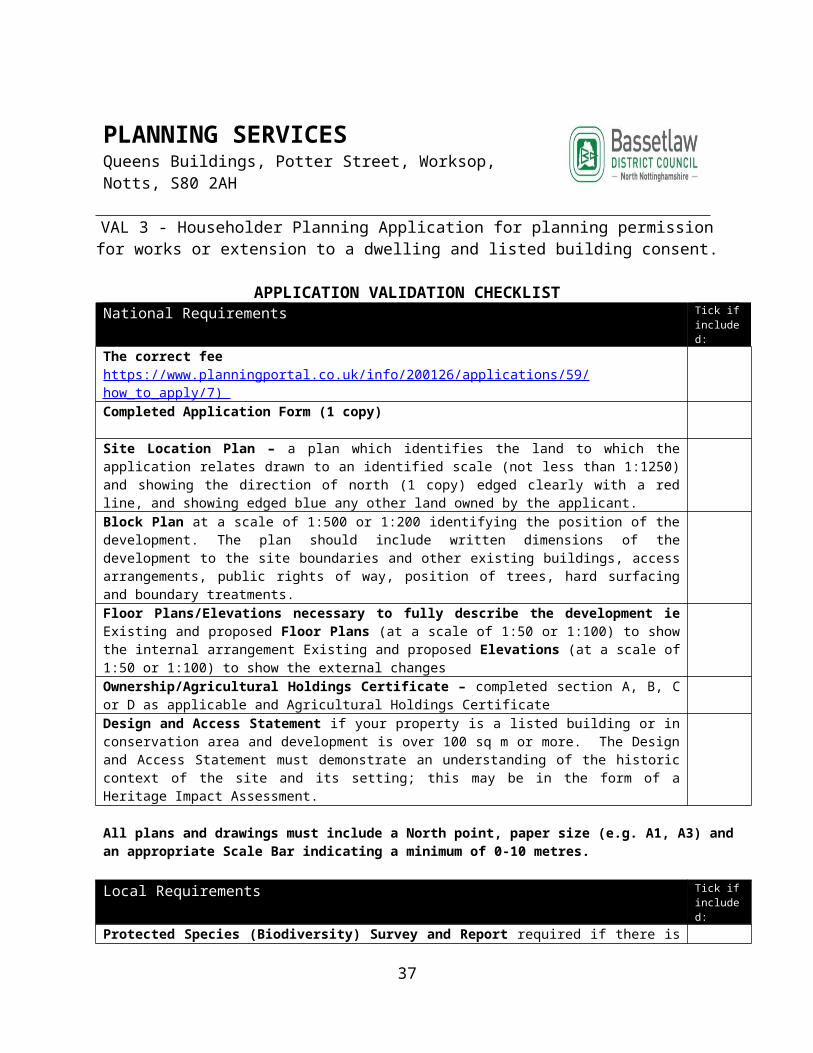
Other Documents Use the space below to list any other documents you are providing in support of your application:
Notes for applicants for all ‘heritage asset’ applications
In accordance with paragraph 128 of the NPPF, Heritage Impact Assessments are required for applications for development or works directly affecting or within the setting of a heritage asset. This includes designated heritage assets (i.e. a Listed Building, a Conservation Area, a Registered Park & Garden or a Scheduled Ancient Monument) and ‘non-designated heritage assets’ (such as local interest buildings, unregistered parks and gardens, unscheduled archaeological remains, etc). The Council has produced guidance on how to produce a Heritage Impact Assessment. This document can be accessed on the website below:
http://www.bassetlaw.gov.uk/planning_and_building/conservation__heritage/heritage_impact_assessments.aspx
Where an application is a notifiable application to Historic England it is always advisable that a Heritage Impact Assessment is submitted. Notifiable applications include:
Development in the setting of a Grade I or II* listed building. Listed Consent Applications for Grade I or II* listed buildings. Development in conservation areas where the land in respect of the application is more than 1000 square meters. Development that is likely to affect the site of a scheduled monument. Development that affects a Grade I or II* Registered Park and Garden or Battlefield.
In determining whether a building/site is regarded as a ‘non-designated heritage asset’, applicants are advised to read Bassetlaw District Council’s criteria for the identification of such assets, ‘Non designated Heritage Asset – Criteria’ using the link below:-
http://www.bassetlaw.gov.uk/services/planning__building/conservation__heritage/non-designated_heritage_assets.aspx
Alternatively, advice can be sought from the Council’s Conservation Team in the Planning Policy and Conservation section of the Planning Department
What happens where the applicant/agent disagrees with the local planning authority request to provide additional information?
There is a procedure in the Development Management Procedure Order to resolve such disputes. An applicant must first send the local planning authority a notice under article 12 of the Town and Country Planning (Development Management Procedure) (England) Order 2015 (an ’article 12 notice’). This must set out the reasons why the applicant considers that the information requested by the local planning authority, in refusing to validate the planning application, does not meet the statutory tests.
For internal use onlyValidation Checked by Date
37

Bassetlaw District Council’s preferred method for receiving applications electronic using the Planning Portal website (www.planningportal.co.uk)
38

PLANNING SERVICES Queens Buildings, Potter Street, Worksop, Notts, S80 2AH
Form 5 - Outline Permission with Some Matters Reserved
APPLICATION VALIDATION CHECKLISTNational Requirements Tick if
included:The correct feehttps://www.planningportal.co.uk/info/200126/applications/59/how_to_apply/7 ) Completed Application Form (1 copy)
Site Location Plan – a plan which identifies the land to which the application relates drawn to an identified scale (not less than 1:1250) and showing the direction of north (1 copy) edged clearly with a red line, and showing edged blue any other land owned by the applicant. Block Plan at a scale of 1:500 or 1:200 identifying the position of the development. The plan should include written dimensions of the development to the site boundaries and other existing buildings, access arrangements, public rights of way, position of trees, hard surfacing and boundary treatments.Existing and Proposed Floor Plans at a scale of 1:50 or 1:100 to show the internal arrangement. Only if Layout for Approval. Illustrative layout needed in all casesExisting and Proposed Elevations at a scale of 1:50 or 1:100 to show external arrangement. Only if Appearance for Approval.Existing and Proposed Site Sections and Finished Floor Levels at a scale of 1:50 or 1:100 only if Layout, Scale or Appearance for approvalOwnership/Agricultural Holdings Certificate – completed section A, B, C or D as applicable and Agricultural Holdings Certificate Design and Access Statement for major planning applications, dwellings in a Conservation Area and where development exceeds 100m2 in a Conservation AreaEnvironmental Assessment is required for major developments over a certain size or where there would be a significant impact on the local environmentHeritage Asset Statement for extensions to a listed building or a building in a conservation area, registered park and garden, scheduled monument or a non-designated heritage asset (if not included as part of design and access statement)
All plans and drawings must include a North point, paper size (e.g. A1, A3) and an appropriate Scale Bar indicating a minimum of 0-10 metres.
Local Requirements Tick if included:
Protected Species (Biodiversity) Survey and ReportRequired if there is a likelihood that protected species (particularly bats) will be affected. The need for a survey should be considered if the property is adjacent to a Site of Specific Interest, a Local Wildlife Site, a Local Nature Reserve or Ancient Woodland, a loft conversion is proposed.Flood Risk Assessment Required if the property is located in a Flood Zone. For advice on flood risk contact the Environment Agency. (now Local Lead Flood Authority at Notts County Council)Heritage StatementRequired if you will be erecting a building or enclosure in the grounds of a Listed Building, in a Conservation Area or is deemed to affect the setting of a Listed Building, scheduled monument or a non-designated heritage asset or you are undertaking excavations in an Archaeological Constraint area.
39

Tree Survey and Report Required if the development directly affects existing trees within or adjacent to the site boundaries.Community Infrastructure Levy Additional Information Form Required for all applications for development of floor space (including residential extensions, for the creation of a new dwellings (of any size), or for the conversion of a new building no longer in use).Structural Survey Required if development involves the re-use or conversion of outbuilding(s) or structure(s) in order to ensure that they are structurally sound and capable of conversion without significant alteration(s)Proposed Floor Plans and Elevations to a scale of 1:50 or 1:100 when the application site is within a Conservation Area or within the setting of a Listed BuildingTransport Assessment if Layout and/or Access applied forRetail Impact Assessment depends on scalePlanning Obligations for developments of over 10 dwellings a draft agreement/heads of terms documentStatement of Community Involvement demonstrating the views of the local community have been taken into account and pre-application discussion with Bassetlaw District CouncilNoise Impact Assessment for proposals which raise issues of noise disturbanceAir Quality Assessment for proposals which impact on air quality or are potential pollutantsUtilities Statement required for residential development of 10 or more dwellings or creation of 1000 square metres or more of floor spaceLighting Scheme where external lighting schemes are proposedPhotographs and PhotomontageOpen Space required for major residential developmentDrainage Assessment required for new development in certain areasArchaeological Assessment required where an application affects any known or suspected archaeological siteAffordable Housing/Viability Reports/Financial Appraisals required where development is more than 10 dwellingsOdour Assessment required in circumstances where the proposed development may place constraints on existing landfill sites or near to sites regulated by the Environment AgencyCrime Avoidance Statement required for larger schemes particularly those which would attract significant numbers of members of the publicCoal Mining Risk Assessment required when the proposal falls within Coal Mining Development Referral AreasSubmission Documents on CD Two Discs required for major developments with a copy of all documents, plans and forms in PDF format
What happens where the applicant/agent disagrees with the local planning authority request to provide additional information?
There is a procedure in the Development Management Procedure Order to resolve such disputes. An applicant must first send the local planning authority a notice under article 12 of the Town and Country Planning (Development Management Procedure) (England) Order 2015 (an ’article 12 notice’). This must set out the reasons why the applicant considers that the information requested by the local planning authority, in refusing to validate the planning application, does not meet the statutory tests.
40

For internal use onlyValidation Checked by Date
Bassetlaw District Council’s preferred method for receiving applications electronic using the Planning Portal website (www.planningportal.co.uk)
41

PLANNING SERVICES Queens Buildings, Potter Street, Worksop, Notts, S80 2AH
Form 6 - Outline Permission with all matters reserved
APPLICATION VALIDATION CHECKLISTNational Requirements Tick if
included:The correct feehttps://www.planningportal.co.uk/info/200126/applications/59/how_to_apply/7 ) Completed Application Form (1 copy)
Site Location Plan – a plan which identifies the land to which the application relates drawn to an identified scale (not less than 1:1250) and showing the direction of north (1 copy) edged clearly with a red line, and showing edged blue any other land owned by the applicant. Block Plan at a scale of 1:500 or 1:200 identifying the position of the development. The plan should include written dimensions of the development to the site boundaries and other existing buildings, access arrangements, public rights of way, position of trees, hard surfacing and boundary treatments.Proposed Floor Plans to a scale of 1:50 or 1:100 required if Layout for approvalProposed Elevations Including Roof Plans to a scale of 1:50 or 1:100 required if Appearance for approvalProposed Site Sections and Finished Floor Levels to a scale of 1:50 or 1:100 required if Layout, Scale or Appearance for approvalEnvironmental Statement may be required – discuss with LPA
All plans and drawings must include a North point, paper size (e.g. A1, A3) and an appropriate Scale Bar indicating a minimum of 0-10 metres.
Local Requirements Tick if included:
Protected Species (Biodiversity) Survey and Report – If not approved at outline stageRequired if there is a likelihood that protected species (particularly bats) will be affected. The need for a survey should be considered if the property is adjacent to a Site of Specific Interest, a Local Wildlife Site, a Local Nature Reserve or Ancient Woodland, a loft conversion is proposed.Flood Risk Assessment – If not approved at outline stageRequired if the property is located in a Flood Zone. For advice on flood risk contact the Environment Agency. (now Local Lead Flood Authority at Notts County Council)Heritage Impact Assessment– If not approved at outline stageRequired if you will be erecting a building or enclosure in the grounds of a Listed Building, in a Conservation Area or is deemed to affect the setting of a Listed Building, Scheduled Monument or a Non-Designated Heritage Asset or you are undertaking excavations in an Archaeological Constraint area.Landscaping Proposals/Tree Survey and Report – If not approved at outline stageRequired if the development directly affects existing trees within or adjacent to the site boundaries.Community Infrastructure Levy Additional Information Form Required for all applications for development of floor space (including residential extensions, for the creation of a new dwellings (of any size), or for the conversion of a new building no longer in use).
42

Details of any Pre-Application Discussion required
Parking Arrangements/Cycle Storage – If not approved at outline stage
Refuse Storage/Recycling Details – If not approved at outline stageContaminated Land Survey – If not approved at outline stageGreen Travel Plan – If not approved at outline stageNoise Impact Assessment – If not approved at outline stageAir Quality Assessment – If not approved at outline stageUtilities Statement – If not approved at outline stageDetails of any Lighting Scheme – If not approved at outline stagePhotographs & Photomontage – Only if appearance appliedOpen Space – If not approved at outline stageDrainage Assessment – If not approved at outline stageArchaeological Assessment – If not approved at outline stageSubmission Documents on CD Two Discs required for major developments with a copy of all documents, plans and forms in PDF format
What happens where the applicant/agent disagrees with the local planning authority request to provide additional information?
There is a procedure in the Development Management Procedure Order to resolve such disputes. An applicant must first send the local planning authority a notice under article 12 of the Town and Country Planning (Development Management Procedure) (England) Order 2015 (an ’article 12 notice’). This must set out the reasons why the applicant considers that the information requested by the local planning authority, in refusing to validate the planning application, does not meet the statutory tests.
For internal use onlyValidation Checked by Date
Bassetlaw District Council’s preferred method for receiving applications electronic using the Planning Portal website (www.planningportal.co.uk)
43

Validation Checklist 1.Non-Householder Planning Applications2.Planning Permission and Advertisement Consent
3.Planning Permission and Listed Building Consent4. Planning Permission and Demolition in a Conservation Area
5 &6.Application for Reserved Matters (some or all matters reserved)
Completed form (1 copy) including completed ownership and Agricultural Holdings Certificate (A, B, C or In addition, where Ownership Certificates B, C or D have been completed, notice(s) as required by Article 7 of the DMPO must be published in accordance with this Article
Completed form (1 copy) including completed ownership and Agricultural Holdings Certificate (A, B, C or In addition, where Ownership Certificates B, C or D have been completed, notice(s) as required by Article 7 of the DMPO must be published in accordance with this Article
Completed form (1 copy) including completed ownership and Agricultural Holdings Certificate (A, B, C or In addition, where Ownership Certificates B, C or D have been completed, notice(s) as required by Article 7 of the DMPO must be published in accordance with this Article
Publication of Notices in line with Article 7 of DMPO where ownership Certificates B,C, D completed
Publication of Notices in line with Article 7 of DMPO where ownership Certificates B,C, D completed
Publication of Notices in line with Article 7 of DMPO where ownership Certificates B,C, D completed
Plan (1 copy unless submitting a major application then 4 copies) showing the direction of north which identify the land to which the application relatesSite Location Plan (scale of 1:1250 or 1:2500)Site Plan (1:500 or 1:200)
Plan (1 copy unless submitting a major application then 4 copies) showing the direction of north which identify the land to which the application relatesSite Location Plan (scale of 1:1250 or 1:2500)Site Plan (1:500 or 1:200)
Plan (1 copy unless submitting a major application then 4 copies) showing the direction of north which identify the land to which the application relatesSite Location Plan (scale of 1:1250 or 1:2500)Site Plan (1:500 or 1:200)
Design and Access Statement, if the dwelling is a Listed Building or within a Conservation Area or a Site of Special Scientific Interest.
Design and Access StatementHeritage StatementStructural SurveyPhotographs and PhotomontagesElevations of attached buildings
Design and Access Statement unless solely for engineering operationsUse(s) and Indicative LayoutAccess Points to site
Block plan of the site (e.g. at a scale of 1:100 or 1:200) showing any site boundaries;Existing and proposed elevations (e.g. at a scale of 1:50 or 1:100);Existing and proposed floor plans (e.g. at a scale of 1:50 or 1:100);Existing and proposed site sections and finished floor and site levels (e.g. at a scale of 1:50 or 1:100);Roof plans (e.g. at a scale of 1:50 or 1:100)
Block plan of the site (e.g. at a scale of 1:100 or 1:200) showing any site boundaries;Existing and proposed elevations (e.g. at a scale of 1:50 or 1:100);Existing and proposed floor plans (e.g. at a scale of 1:50 or 1:100);Existing and proposed site sections and finished floor and site levels (e.g. at a scale of 1:50 or 1:100);Roof plans (e.g. at a scale of 1:50 or 1:100)
Block plan of the site (e.g. at a scale of 1:100 or 1:200) showing any site boundaries;Existing and proposed elevations (e.g. at a scale of 1:50 or 1:100);Existing and proposed floor plans (e.g. at a scale of 1:50 or 1:100);Existing and proposed site sections and finished floor and site levels (e.g. at a scale of 1:50 or 1:100);Roof plans (e.g. at a scale of 1:50 or 1:100)
The Correct Fee The Correct Fee The Correct Fee.
44

Validation Checklist
7. Application for Listed Building Consent8. Lawful Development Certificates (Proposed Works and/or Use)9. Lawful Development Certificate (Existing Works and/or Use)10. Certificate of Lawfulness of Proposed Works to a Listed Building
45
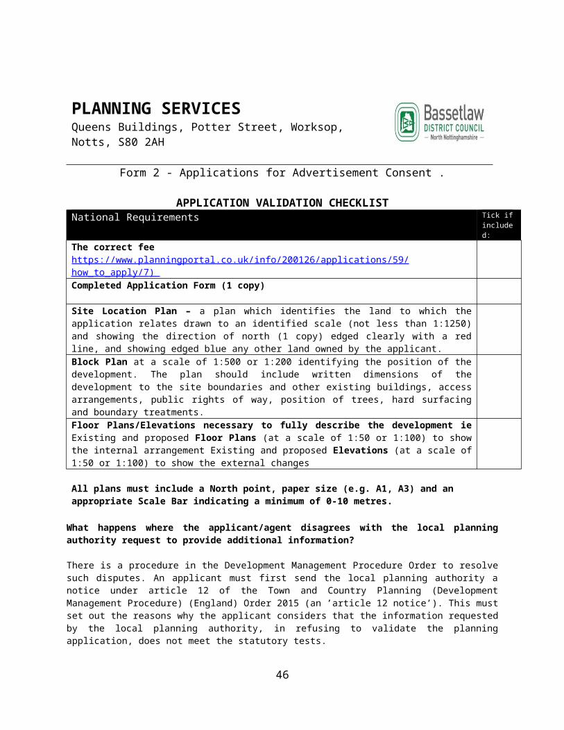
PLANNING SERVICES Queens Buildings, Potter Street, Worksop, Notts, S80 2AH
Form 7 - Listed Building Consent for Alterations, Consent, Extension or Demolition of a Listed Building
APPLICATION VALIDATION CHECKLISTNational Requirements Tick if
included:Completed Application Form (1 copy)
Site Location Plan – to scale of 1:250 or 1:2500 a plan which identifies the land to which the application relates drawn to an identified scale and showing the direction of north (1 copy) edged clearly with a red line, and showing edged blue any other land owned by the applicant. Block Plan at a scale of 1:500 or 1:200 identifying the position of the development. The plan should include written dimensions of the development to the site boundaries and other existing buildings, access arrangements, public rights of way, position of trees, hard surfacing and boundary treatments.Floor Plans/Elevations necessary to fully describe the development i.e. Existing and Proposed Floor Plans (at a scale of 1:50 or 1:100) to show the internal arrangement Existing and Proposed Elevations (at a scale of 1:50 or 1:100) to show the external changesSite Sections and Finished Floor Levels Existing and Proposed (at a scale not smaller than 1:100)Ownership/Agricultural Holdings Certificate – completed section A, B, C or D as applicable Design and Access Statement. The Design and Access Statement must demonstrate an understanding of the historic context of the site and its setting; this may be in the form of a Heritage Impact Assessment.
All plans and drawings must include a North point, paper size (e.g. A1, A3) and an appropriate Scale Bar indicating a minimum of 0-10 metres.
Local Requirements Tick if included:
Sections through building where the proposed work would affect more than one floor, i.e. through the building such as the insertion of a stair case.
Pre- application discussion: Details of any pre-application discussion held with the Local Planning Authority or Historic England.
Structural survey of the building required if the proposals are for demolition or alteration on structural grounds to ensure that the local planning authority has necessary information to assess the extent of repair, replacement or rebuilding.
Heritage Impact Assessment: A Statement of Significance of the architectural and historic interest of the building and its setting, in accordance with Section 12 of the National Planning Policy Framework. The Assessment must clearly explain the impact of the proposed works on the listed building and its setting. See detailed advice in Part 3 of the Validation Guidelines.
46

Photographs of the listed building and the area affected by the proposals.
Details of proposal for the site following demolition.
Notes for applicants for all ‘heritage asset’ applications
In accordance with paragraph 128 of the NPPF, Heritage Impact Assessments are required for applications for development or works directly affecting or within the setting of a heritage asset. This includes designated heritage assets (i.e. a Listed Building, a Conservation Area, a Registered Park & Garden or a Scheduled Ancient Monument) and ‘non-designated heritage assets’ (such as local interest buildings, unregistered parks and gardens, unscheduled archaeological remains, etc). The Council has produced guidance on how to produce a Heritage Impact Assessment. This document can be accessed on the website below:
http://www.bassetlaw.gov.uk/planning_and_building/conservation__heritage/heritage_impact_assessments.aspx
Where an application is a notifiable application to Historic England it is always advisable that a Heritage Impact Assessment is submitted. Notifiable applications include:
Development in the setting of a Grade I or II* listed building. Listed Consent Applications for Grade I or II* listed buildings. Development in conservation areas where the land in respect of the application is more than 1000 square meters. Development that is likely to affect the site of a scheduled monument. Development that affects a Grade I or II* Registered Park and Garden or Battlefield.
What happens where the applicant/agent disagrees with the local planning authority request to provide additional information?
There is a procedure in the Development Management Procedure Order to resolve such disputes. An applicant must first send the local planning authority a notice under article 12 of the Town and Country Planning (Development Management Procedure) (England) Order 2015 (an ’article 12 notice’). This must set out the reasons why the applicant considers that the information requested by the local planning authority, in refusing to validate the planning application, does not meet the statutory tests.
For internal use onlyValidation Checked by Date
Bassetlaw District Council’s preferred method for receiving applications electronic using the Planning Portal website (www.planningportal.co.uk)
47

PLANNING SERVICES Queens Buildings, Potter Street, Worksop, Notts, S80 2AH
Form 8 - Applications for A Certificate of Lawfulness (Proposed Use) (S192 TCP Act)
APPLICATION VALIDATION CHECKLISTNational Requirements Tick if
included:The correct feehttps://www.planningportal.co.uk/info/200126/applications/59/how_to_apply/7 ) Completed Application Form (1 copy)
Site Location Plan – a plan which identifies the land to which the application relates drawn to an identified scale (not less than 1:1250) and showing the direction of north (1 copy) edged clearly with a red line, and showing edged blue any other land owned by the applicant. Such evidence verifying the information included in the application as can be providedOther information relevant to the application where this is operational development Floor Plans/Elevations necessary to fully describe the development ie Existing and proposed Floor Plans (at a scale of 1:50 or 1:100) to show the internal arrangement Existing and proposed Elevations (at a scale of 1:50 or 1:100) to show the external changes are required
All plans must include a North point, paper size (e.g. A1, A3) and an appropriate Scale Bar indicating a minimum of 0-10 metres.
What happens where the applicant/agent disagrees with the local planning authority request to provide additional information?
There is a procedure in the Development Management Procedure Order to resolve such disputes. An applicant must first send the local planning authority a notice under article 12 of the Town and Country Planning (Development Management Procedure) (England) Order 2015 (an ’article 12 notice’). This must set out the reasons why the applicant considers that the information requested by the local planning authority, in refusing to validate the planning application, does not meet the statutory tests.
Community Infrastructure Levy Administration Forms Tick if included:
The CIL Additional Information Form – to determine whether development is CIL liable if proposal seeks planning permission for development over 100 sq m (including residential extensions, new dwelling of an size, conversion/change of use of a building no longer in use).
What happens where the applicant/agent disagrees with the local planning authority request to provide additional information?
There is a procedure in the Development Management Procedure Order to resolve such disputes. An applicant must first send the local planning authority a notice under article 12 of the Town and Country Planning (Development Management Procedure) (England) Order 2015 (an ’article 12 notice’). This must set out the reasons why the applicant considers that the information requested by the local planning authority, in refusing to validate the planning application, does not meet the statutory tests.
48

For internal use onlyValidation Checked by Date
Bassetlaw District Council’s preferred method for receiving applications electronic using the Planning Portal website (www.planningportal.co.uk)
49

PLANNING SERVICES Queens Buildings, Potter Street, Worksop, Notts, S80 2AH
Form 9 - Applications for A Certificate of Lawfulness (Existing (S191 TCP Act)
APPLICATION VALIDATION CHECKLISTNational Requirements Tick if
included:The correct feehttps://www.planningportal.co.uk/info/200126/applications/59/how_to_apply/7 ) Completed Application Form (1 copy)
Site Location Plan – a plan which identifies the land to which the application relates drawn to an identified scale (not less than 1:1250) and showing the direction of north (1 copy) edged clearly with a red line, and showing edged blue any other land owned by the applicant. Such evidence verifying the information included in the application as can be providedOther information relevant to the application where this is operational development Floor Plans/Elevations necessary to fully describe the development ie Existing and proposed Floor Plans (at a scale of 1:50 or 1:100) to show the internal arrangement Existing and proposed Elevations (at a scale of 1:50 or 1:100) to show the external changes are required
All plans must include a North point, paper size (e.g. A1, A3) and an appropriate Scale Bar indicating a minimum of 0-10 metres.
What happens where the applicant/agent disagrees with the local planning authority request to provide additional information?
There is a procedure in the Development Management Procedure Order to resolve such disputes. An applicant must first send the local planning authority a notice under article 12 of the Town and Country Planning (Development Management Procedure) (England) Order 2015 (an ’article 12 notice’). This must set out the reasons why the applicant considers that the information requested by the local planning authority, in refusing to validate the planning application, does not meet the statutory tests.
For internal use onlyValidation Checked by Date
Bassetlaw District Council’s preferred method for receiving applications electronic using the Planning Portal website (www.planningportal.co.uk)
50

PLANNING SERVICES Queens Buildings, Potter Street, Worksop, Notts, S80 2AH
Form 10 - Certificate of Lawfulness of Proposed Works to a Listed Building
APPLICATION VALIDATION CHECKLISTNational Requirements Tick if
included:Completed Application Form (1 copy)
Site Location Plan to scale of 1:250 or 1:2500 a plan which identifies the land to which the application relates drawn to an identified scale and showing the direction of north (1 copy).The building should be highlighted with a coloured boundary or shaded.
Description of the proposed works (including existing and proposed materials and finishes) together with details of those part(s) of the building likely to be affected. This may include a schedule of works. This should include photographs of the affected areas.
A Heritage Impact Assessment that explains the reasons the applicant thinks they are entitled to a Certificate of Lawfulness of Proposed Works i.e. why they think the proposed works do not affect the special architectural or historic interest of the listed buildingInterest in the building. A statement as to the applicant's interest (ownership, tenancy etc) in the listed building(s) and any interest of any other person, see Section 8 of the application form.
Supporting information (where appropriate) Floor Plans/Elevations. Photographs to show the building and areas affected by the application. Evidence in support of the application.
What happens where the applicant/agent disagrees with the local planning authority request to provide additional information?
There is a procedure in the Development Management Procedure Order to resolve such disputes. An applicant must first send the local planning authority a notice under article 12 of the Town and Country Planning (Development Management Procedure) (England) Order 2015 (an ’article 12 notice’). This must set out the reasons why the applicant considers that the information requested by the local planning authority, in refusing to validate the planning application, does not meet the statutory tests.
51

For internal use onlyValidation Checked by Date
Bassetlaw District Council’s preferred method for receiving applications electronic using the Planning Portal website (www.planningportal.co.uk)
52
7.Application for Listed Building Consent
Completed form (4 copies Plan (4 copies unless submitted electronically) showing the direction of north which identify the land to which the application relatesSite Location Plan (scale of 1:1250 or 1:2500)Site Plan (1:500 or 1:200) Existing and proposed elevations (e.g. at a scale of 1:50 or 1:100); Advertisement drawings at a scale of (1:50 or 1:100) size, siting, materials and colours or advertisements and methods of illumination No fee

8.Lawful Development Certificate-existing use or operation including breach of a planning condition
9.Lawful Development Certificate-Proposed Use or operation
10. Application for Lawful Development Certificate for Proposed works to a Listed Building
Completed form (4 copies) (A, B, C or D)
Completed form (4 copies) (A, B, C or D)
A plan identifying the listed buildings related to application
Plan (4 copies unless submitted electronically) showing the direction of north which identify the land to which the application relatesSite Location Plan (scale of 1:1250 or 1:2500)Site Plan (1:500 or 1:200)
Plan (4 copies unless submitted electronically) showing the direction of north which identify the land to which the application relatesSite Location Plan (scale of 1:1250 or 1:2500)Site Plan (1:500 or 1:200)
A detailed description of the proposed works (existing and proposed materials and finishes, parts of buildings likely to be affected special architectural or historic interest of the listed building
Such evidence verifying the information included in the application as can be provided
Such evidence verifying the information included in the application as can be provided
A statement as to the applicant’s interest in the land and the interest of any other person
Other information relevant to the application
Other information relevant to the application
Details of Listed Building grading *
The Correct Fee The Correct Fee Any other relevant information
WARNING: Section 26J of the Planning (Listed Buildings and Conservation Areas) Act 1990 provides that it is an offence to furnish false or misleading information or to withhold material information with intent to deceive. Section 26I(6) enables the authority to revoke, at any time, a Certificate they may have issued as a result of such false or misleading information.
53

APPENDIX 1C: PRIOR-NOTIFICATION APPLICATIONS (EXCEPT WORKS TO TREES IN A CONSERVATION AREA)
Application for prior notification of:
1. Proposed demolition works
2. Proposed agricultural development
3. Proposed development (telecommunications)
54

PLANNING SERVICES Queens Buildings, Potter Street, Worksop, Notts, S80 2AH
Form PN 1 - Application for prior notification of proposed demolition.
APPLICATION VALIDATION CHECKLIST
National Requirement Tick if included:
The correct fee (https://www.planningportal.co.uk/info/200126/applications/59/how_to_apply/7 )
Completed Application Form (1 copy)
Site Location Plan – a plan to a suitable scale (1:1250 or 1:2500) which identifies the land to which the application relates drawn to an identified scale and showing the direction of north (1 copy) with the site of the proposed building clearly outlined with a red line, and any other land owned by the applicant showing edged blue
Site Notice - The Applicant must display a site notice by site display on or near the land on which the building to be demolished is sited and must leave the notice in place for not less than 21 days in the period of 28 days beginning with the date on which the application was submitted to the local Planning Authority, A copy of this site notice must be included as part of the prior notification submission. Please note a site notice template is available if required on the Bassetlaw District Council Website.
Written Request to check whether the building has been nominated – In cases where the building is not a community asset and is used for a purpose falling within Class A4 (drinking establishments) of the schedule to the Use Classes Order, a written request to the local planning authority as to whether the building has been nominated needs to be submitted.
All plans and drawings must include a North point, paper size (e.g. A1, A3) and an appropriate Scale Bar indicating a minimum of 0-10 metres.
What happens where the applicant/agent disagrees with the local planning authority request to provide additional information?
There is a procedure in the Development Management Procedure Order to resolve such disputes. An applicant must first send the local planning authority a notice under article 12 of the Town and Country Planning (Development Management Procedure) (England) Order 2015 (an ’article 12 notice’). This must set out the reasons why the applicant considers that the information requested by the local planning authority, in refusing to validate the planning application, does not meet the statutory tests.
Bassetlaw District Council’s preferred method for receiving applications electronic using the Planning Portal website (www.planningportal.co.uk)
55

56

PLANNING SERVICES Queens Buildings, Potter Street, Worksop, Notts, S80 2AH
Application for prior notification of proposed development by telecommunications code system operators.
APPLICATION VALIDATION CHECKLIST
National Requirement Tick if included:
The correct fee (https://www.planningportal.co.uk/info/200126/applications/59/how_to_apply/7 )
Completed Prior Notification Form (1 copy)
Site Location Plan – a plan to a suitable scale (1:1250 or 1:2500) which identifies the land to which the application relates drawn to an identified scale and showing the direction of north (1 copy) with the site of the proposed building clearly outlined with a red line, and any other land owned by the applicant showing edged blue.
Where sub-paragraph (3) of the Regulations applies, evidence that the Civil Aviation Authority, the Secretary of State for Defence or the aerodrome operator, as the case may be, has been notified of the proposal - Where the proposed development consists of the installation, alteration or replacement of a mast within 3 kilometres of the perimeter of an aerodrome, the developer must notify the Civil Aviation Authority, the Secretary of State for Defence or the aerodrome operator, as appropriate, before submitting the proposal to the Local Authority.
All plans and drawings must include a North point, paper size (e.g. A1, A3) and an appropriate Scale Bar indicating a minimum of 0-10 metres.
What happens where the applicant/agent disagrees with the local planning authority request to provide additional information?
There is a procedure in the Development Management Procedure Order to resolve such disputes. An applicant must first send the local planning authority a notice under article 12 of the Town and Country Planning (Development Management Procedure) (England) Order 2015 (an ’article 12 notice’). This must set out the reasons why the applicant considers that the information requested by the local planning authority, in refusing to validate the planning application, does not meet the statutory tests.
Bassetlaw District Council’s preferred method for receiving applications electronic using the Planning Portal website (www.planningportal.co.uk)
57

PLANNING SERVICES Queens Buildings, Potter Street, Worksop, Notts, S80 2AH
Application for prior notification of proposed agricultural development: Road, building, excavation/deposit of waste material, fish tank)
APPLICATION VALIDATION CHECKLIST
National Requirement Tick if included:
The correct fee (https://www.planningportal.co.uk/info/200126/applications/59/how_to_apply/7 )
Completed Prior Notification Form (1 copy)
Site Location Plan – a plan to a suitable scale (1:1250 or 1:2500) which identifies the land to which the application relates drawn to an identified scale and showing the direction of north (1 copy) with the site of the proposed building clearly outlined with a red line, and any other land owned by the applicant showing edged blue.
May require the following;Existing and proposed elevationsSite sections and floor plans (Scale 1:50 or 1:100), finished floor and site levelsPhotographs/photomontagesLandscaping detailsStatement justifying developmentWhere sub-paragraph (3) of the Regulations applies, evidence that the Civil Aviation Authority, the Secretary of State for Defence or the aerodrome operator, as the case may be, has been notified of the proposal - Where the proposed development consists of the installation, alteration or replacement of a mast within 3 kilometres of the perimeter of an aerodrome, the developer must notify the Civil Aviation Authority, the Secretary of State for Defence or the aerodrome operator, as appropriate, before submitting the proposal to the Local Authority.
All plans and drawings must include a North point, paper size (e.g. A1, A3) and an appropriate Scale Bar indicating a minimum of 0-10 metres.
What happens where the applicant/agent disagrees with the local planning authority request to provide additional information?
There is a procedure in the Development Management Procedure Order to resolve such disputes. An applicant must first send the local planning authority a notice under article 12 of the Town and Country Planning (Development Management Procedure) (England) Order 2015 (an ’article 12 notice’). This must set out the reasons why the applicant considers that the information requested by the local planning authority, in refusing to validate the planning application, does not meet the statutory tests.
58

Bassetlaw District Council’s preferred method for receiving applications electronic using the Planning Portal website (www.planningportal.co.uk)
59

Validation Checklist
1.Prior-Notification: Proposed Demolition
2.Prior-Notification: Proposed agricultural development: Road, building, excavation/deposit of waste material, fish tank)
3.Prior-Notification: Proposed development under permitted development of telecommunications
A completed form or written description of the development
A completed form or written description of the development
A completed form or written description of the development
Statement site notice displayed in accordance with B.2(b) of Part 11 of the GPDO 2015
Plan indicating site (4 copies unless submitted electronicallyMay require the following;Existing and proposed elevationsSite sections and floor plans (Scale 1:50 or 1:100), finished floor and site levelsPhotographs/photomontagesLandscaping detailsStatement justifying development
Plan indicating proposed location
May be required to submit plan of site and extent of demolition works, details of methods of demolition and details of finishes appearance and/or treatment of the site
Evidence developer ash given notice in accordance with Part 16 of the GPDO 2015.Elevational drawings showing appearance of all elements of installationLandscaping proposals
Other conditions and information required*
The appropriate fee The appropriate fee The appropriate fee
*Where the proposed development consists of the installation of a mast within three kilometres of the perimeter of an aerodrome, evidence that the developer has notified the Civil Aviation Authority, the Secretary of State for Defence or the Aerodrome operator in accordance with Part 16 of the General Permitted Development Order 1995
Other relevant additional information (based upon the Supplementary Information Template as set out in Annex F of the Code of Best Practice on Mobile Phone Network Development) and including:
Site selection criteria and alternatives considered Pre-application consultation carried out and responses Consultation with nearby schools and responses Details of structures ICNIRP declaration Coverage plots and Mast sharing options
60

PART 1D: OTHER APPLICATIONS
VALIDATION REQUIREMENTS
1. Application for Hedgerow Removal Notice2. Application for the Removal or Variation of a planning condition 3. Application for Non-Material Amendments4. Application for approval of details reserved by condition (AODs)5. Application for the Removal or Variation of a planning condition following
grant of planning permission (S73A of TPC Act)6. Application for works to Trees subject to TPO and Prior Notification of works
to Trees in a Conservation Area7. Application for the Deemed Discharge of Conditions8. Application for Householder Planning Application for planning permission for
works or extension to a dwelling where Article 4 Direction is in force
61

PLANNING SERVICES Queens Buildings, Potter Street, Worksop, Notts, S80 2AH
Application for Hedgerow removal notice
APPLICATION VALIDATION CHECKLIST
National Requirement Tick if included:
The correct fee (https://www.planningportal.co.uk/info/200126/applications/59/how_to_apply/7 )
Completed Prior Notification Form (1 copy)
Site Location Plan – a plan to a suitable scale (1:1250 or 1:2500) showing length and location of hedgerows to be removed
Evidence of date of PlantingAdditional information including species within hedgerow, presence of trees, wildlife habitats and any replanting proposals or mitigating measures
All plans and drawings must include a North point, paper size (e.g. A1, A3) and an appropriate Scale Bar indicating a minimum of 0-10 metres.
What happens where the applicant/agent disagrees with the local planning authority request to provide additional information?
There is a procedure in the Development Management Procedure Order to resolve such disputes. An applicant must first send the local planning authority a notice under article 12 of the Town and Country Planning (Development Management Procedure) (England) Order 2015 (an ’article 12 notice’). This must set out the reasons why the applicant considers that the information requested by the local planning authority, in refusing to validate the planning application, does not meet the statutory tests.
Bassetlaw District Council’s preferred method for receiving applications electronic using the Planning Portal website (www.planningportal.co.uk)
62

PLANNING SERVICES Queens Buildings, Potter Street, Worksop, Notts, S80 2AH
Removal or Variation of a Condition Following Grant of Planning Permission
APPLICATION VALIDATION CHECKLISTNational Requirements Tick if
included:The correct feehttps://www.planningportal.co.uk/info/200126/applications/59/how_to_apply/7 ) Completed Application Form (1 copy)
Floor Plans/Elevations necessary to fully describe the development ie Existing and proposed Floor Plans (at a scale of 1:50 or 1:100) to show the internal arrangement Existing and proposed Elevations (at a scale of 1:50 or 1:100) to show the external changesOwnership/Agricultural Holdings Certificate – completed section A, B, C or D as applicable and Agricultural Holdings Certificate Block Plans to a scale of 1:500 and information necessary to describe the subject of the application
All plans and drawings must include a North point, paper size (e.g. A1, A3) and an appropriate Scale Bar indicating a minimum of 0-10 metres.
Local Requirements Tick if included:
Community Infrastructure Levy Administration Forms Tick if included:
The CIL Additional Information Form – to determine whether development is CIL liable if proposal seeks planning permission for development over 100 sq m (including residential extensions, new dwelling of an size, conversion/change of use of a building no longer in use).
What happens where the applicant/agent disagrees with the local planning authority request to provide additional information?
There is a procedure in the Development Management Procedure Order to resolve such disputes. An applicant must first send the local planning authority a notice under article 12 of the Town and Country Planning (Development Management Procedure) (England) Order 2015 (an ’article 12 notice’). This must set out the reasons why the applicant considers that the information requested by the local planning authority, in refusing to validate the planning application, does not meet the statutory tests.
For internal use onlyValidation Checked by Date
63

Bassetlaw District Council’s preferred method for receiving applications electronic using the Planning Portal website (www.planningportal.co.uk)
64

PLANNING SERVICES Queens Buildings, Potter Street, Worksop, Notts, S80 2AH
Non-Material amendment following a grant of planning permission
APPLICATION VALIDATION CHECKLIST
National Requirements Tick if included:
None
All plans and drawings must include a North point, paper size (e.g. A1, A3) and an appropriate Scale Bar indicating a minimum of 0-10 metres.
Local Requirements Tick if included:
The correct feehttps://www.planningportal.co.uk/info/200126/applications/59/how_to_apply/7 ) Completed Application Form (1 copy)
Site Location Plan – a plan which identifies the land to which the application relates drawn to an identified scale (not less than 1:1250) and showing the direction of north (1 copy) edged clearly with a red line, and showing edged blue any other land owned by the applicant.
Floor Plans/Elevations necessary to fully describe the development ie Existing and proposed Floor Plans (at a scale of 1:50 or 1:100) to show the internal arrangement Existing and proposed Elevations (at a scale of 1:50 or 1:100) to show the external changes
What happens where the applicant/agent disagrees with the local planning authority request to provide additional information?
There is a procedure in the Development Management Procedure Order to resolve such disputes. An applicant must first send the local planning authority a notice under article 12 of the Town and Country Planning (Development Management Procedure) (England) Order 2015 (an ’article 12 notice’). This must set out the reasons why the applicant considers that the information requested by the local planning authority, in refusing to validate the planning application, does not meet the statutory tests.
Bassetlaw District Council’s preferred method for receiving applications electronic using the Planning Portal website (www.planningportal.co.uk)
65

PLANNING SERVICES Queens Buildings, Potter Street, Worksop, Notts, S80 2AH
Application for Approval of Details Reserved by Condition
APPLICATION VALIDATION CHECKLISTNational Requirements Tick if
included:The correct feehttps://www.planningportal.co.uk/info/200126/applications/59/how_to_apply/7 ) Completed Application Form (1 copy)
All plans and drawings must include a North point, paper size (e.g. A1, A3) and an appropriate Scale Bar indicating a minimum of 0-10 metres.
Local Requirements Tick if included:
Information required by the condition – The condition should clearly state the information required. Failure to submit clear and concise information may result in the application being refused
What happens where the applicant/agent disagrees with the local planning authority request to provide additional information?
There is a procedure in the Development Management Procedure Order to resolve such disputes. An applicant must first send the local planning authority a notice under article 12 of the Town and Country Planning (Development Management Procedure) (England) Order 2015 (an ’article 12 notice’). This must set out the reasons why the applicant considers that the information requested by the local planning authority, in refusing to validate the planning application, does not meet the statutory tests.
For internal use onlyValidation Checked by Date
Bassetlaw District Council’s preferred method for receiving applications electronic using the Planning Portal website (www.planningportal.co.uk)
66

PLANNING SERVICES Queens Buildings, Potter Street, Worksop, Notts, S80 2AH
Removal or Variation of a Condition Following Grant of Planning Permission
APPLICATION VALIDATION CHECKLISTNational Requirements Tick if
included:The correct feehttps://www.planningportal.co.uk/info/200126/applications/59/how_to_apply/7 ) Completed Application Form (1 copy)
Floor Plans/Elevations necessary to fully describe the development ie Existing and proposed Floor Plans (at a scale of 1:50 or 1:100) to show the internal arrangement Existing and proposed Elevations (at a scale of 1:50 or 1:100) to show the external changesOwnership/Agricultural Holdings Certificate – completed section A, B, C or D as applicable and Agricultural Holdings Certificate Block Plans to a scale of 1:500 and information necessary to describe the subject of the application
All plans and drawings must include a North point, paper size (e.g. A1, A3) and an appropriate Scale Bar indicating a minimum of 0-10 metres.
Local Requirements Tick if included:
Community Infrastructure Levy Administration Forms Tick if included:
The CIL Additional Information Form – to determine whether development is CIL liable if proposal seeks planning permission for development over 100 sq m (including residential extensions, new dwelling of an size, conversion/change of use of a building no longer in use).
What happens where the applicant/agent disagrees with the local planning authority request to provide additional information?
There is a procedure in the Development Management Procedure Order to resolve such disputes. An applicant must first send the local planning authority a notice under article 12 of the Town and Country Planning (Development Management Procedure) (England) Order 2015 (an ’article 12 notice’). This must set out the reasons why the applicant considers that the information requested by the local planning authority, in refusing to validate the planning application, does not meet the statutory tests.
For internal use onlyValidation Checked by Date
67

Bassetlaw District Council’s preferred method for receiving applications electronic using the Planning Portal website (www.planningportal.co.uk)
68

PLANNING SERVICES Queens Buildings, Potter Street, Worksop, Notts, S80 2AH
Works to Trees Subject or Tree Preservation Orders (TPOs) or trees within a Conservation Area.
APPLICATION VALIDATION CHECKLISTNational Requirements Tick if
included:The correct feehttps://www.planningportal.co.uk/info/200126/applications/59/how_to_apply/7 ) Completed Application Form (1 copy)
Site Location Plan – a plan which identifies the land to which the application relates drawn to an identified scale (not less than 1:1250) and showing the direction of north (1 copy) edged clearly with a red line, and showing edged blue any other land owned by the applicant. Full and clear specification of proposed works and statement of reasons for the proposed works Whether the Trees is subject to a TPO or lies within a Conservation Area Sketch plan showing location of tree(s)Additional information including:
Photographs and illustrations Aboricultural report or statement by Aboriculturalist Details of any assistance or advice sought from LPA prior to submission of this form
For TPO applications evidence and support in statement of reasons submitted as required by application form with regard to health and safety concerns, or alleged and potential subsidence
The Site Location Plan must include a North point, paper size (e.g. A1, A3) and an appropriate Scale Bar indicating a minimum of 0-10 metres.
Local Requirements Tick if included:
Tree Survey and Report required if the development directly affects existing trees within or adjacent to the site boundaries.
What happens where the applicant/agent disagrees with the local planning authority request to provide additional information?
There is a procedure in the Development Management Procedure Order to resolve such disputes. An applicant must first send the local planning authority a notice under article 12 of the Town and Country Planning (Development Management Procedure) (England) Order 2015 (an ’article 12 notice’). This must set out the reasons why the applicant considers that the information requested by the local planning authority, in refusing to validate the planning application, does not meet the statutory tests.
For internal use onlyValidation Checked by Date
69

Bassetlaw District Council’s preferred method for receiving applications electronic using the Planning Portal website (www.planningportal.co.uk)
70

Validation Checklist
1.Hedgerow removal notice
2. Application for Removal of Variation of a Planning Condition
3.Non-Material Amendment
4.Application for Approval of details reserved by condition
Completed form (1 copy)
Completed form (1 copy)
Completed form (1 copy)
Completed form (1 copy)
Plan scale 1:2500 showing length and location of hedgerows to be removed
Plan identifying the land Scale 1:1250 or 1:2500 showing direction of north
Previously approved drawings
Relevant information listed in condition(s) subject to the application
Evidence of date of planting
Quote and details of condition to be varied/removed
Proposed drawings indicating proposed differences (scale 1:50 or 1:100)
Extensive detailed and specialist information may be required. (Recommend check with planning service for guidance pre-submission)
Other relevant informationAdditional
information including species within hedgerow, presence of trees, wildlife habitats and any replanting proposals or mitigating measuresAppropriate Fee Appropriate Fee Appropriate Fee Appropriate Fee
5.Application Variation of Condition on Grant of Planning Permission (s73A application)
6.Application to Works to TPO Tree or Prior Notification for Works to Tree in Conservation Area
Completed form (1 copy) including completed ownership and Agricultural Holdings Certificate (A, B, C or in addition, where Ownership Certificates B, C or D have been completed, notice(s) as required by Article 7 of the DMPO must be published in accordance with this Article
Completed and dated application form Sketch plan showing location of tree(s)Full and clear specification of proposed works and statement of reasons for the proposed worksWhether the Trees is subject to a TPO or lies within a Conservation Area
Where condition impacts on physical development may require:Plans (1 copy) Site Location Plan (scale of 1:1250 or 1:2500)Site Plan (1:500 or 1:200) Block plan of the site (e.g. at a scale of 1:100 or 1:200) showing any site boundaries;Existing and proposed elevations (e.g. at a scale of 1:50 or 1:100);Existing and proposed floor and site levels plans (e.g. at a scale of 1:50 or 1:100);
Additional information including:Photographs and illustrationsAboricultural report or statement by AboriculturalistDetails of any assistance or advice sought from LPA prior to submission of this form
For TPO applications evidence and support in statement of reasons submitted as required by application form with regard to health and safety concerns, or alleged and potential subsidence
The appropriate Fee The Appropriate Fee
71

Notification for Deemed Discharge of Conditions S29 of Infrastructure Act 2015 (inserting s74A into the Town and Country Planning Act 1990). Part 5 of the Town and Country Planning (Development Management Procedure (England) Order 1995
NATIONAL REQUIREMENTS ONLY
An application must be giving sufficient information to identify the permission; provide details of the application and identify the condition.
Include particulars, plans and drawings (as necessary) to deal with the application.
Application must be minimum of 6 weeks from date relevant planning application registered and confirm that no appeal has been lodged (if more than 8 weeks
The deemed discharge notice must Specify the date on which the deemed consent will take effect (either the 8 week date or 14 days after the notice is received, whichever is later unless an agreed later date has been agreed with the Local Planning Authority.
A plan identifying the buildings to which the application referred.
There is no fee for this notice
The type of conditions which are excepted from the deemed discharge procedure are set out in Schedule 6 of the and Country Planning (Development Management Procedure (England) Order 1995
Please note that the deemed consent provisions do not apply to all planning permissions or all types of conditions. The exemptions are set out in Article 30 and Schedule 6 of the DMPO.
72

PLANNING SERVICES Queens Buildings, Potter Street, Worksop, Notts, S80 2AH
Deemed Discharge of Conditions
APPLICATION VALIDATION CHECKLISTNational Requirements Only Tick if
included:The is no fee for this notice
Completed Application Form (1 copy)
An application must be giving sufficient information to identify the permission; provide details of the application and identify the condition.Include particulars, plans and drawings (as necessary) to deal with the application.Application must be minimum of 6 weeks from date relevant planning application registered and confirm that no appeal has been lodged (if more than 8 weeksSite Location Plan: Identifying the buildings/land to which the application referred Suggested Scales 1: 500 or 1:1250 or 1:2500 whatever is considered more appropriateThe type of conditions which are excepted from the deemed discharge procedure are set out in Schedule 6 of the and Country Planning (Development Management Procedure (England) Order 1995
All plans and drawings must include a North point, paper size (e.g. A1, A3) and an appropriate Scale Bar indicating a minimum of 0-10 metres.
You are strongly recommended to speak to the Local Planning Authority Prior to service of such a Notice
What happens where the applicant/agent disagrees with the local planning authority request to provide additional information?
There is a procedure in the Development Management Procedure Order to resolve such disputes. An applicant must first send the local planning authority a notice under article 12 of the Town and Country Planning (Development Management Procedure) (England) Order 2015 (an ’article 12 notice’). This must set out the reasons why the applicant considers that the information requested by the local planning authority, in refusing to validate the planning application, does not meet the statutory tests.
For internal use onlyValidation Checked by Date
Bassetlaw District Council’s preferred method for receiving applications electronic using the Planning Portal website (www.planningportal.co.uk)
73

PLANNING SERVICES Queens Buildings, Potter Street, Worksop, Notts, S80 2AH
Article 4 Direction in a Conservation AreaHouseholder Planning Application for planning permission for works or
extension to a dwelling.
APPLICATION VALIDATION CHECKLISTNational Requirements Tick if
included:No Fee - provided the development being applied for is only as a result of the removal of permitted rights by the Article 4 Direction. Completed Application Form (1 copy)
Site Location Plan – a plan which identifies the land to which the application relates drawn to an identified scale (not less than 1:1250) and showing the direction of north (1 copy) edged clearly with a red line, and showing edged blue any other land owned by the applicant. Block Plan at a scale of 1:500 or 1:200 identifying the position of the development. The plan should include written dimensions of the development to the site boundaries and other existing buildings, access arrangements, public rights of way, position of trees, hard surfacing and boundary treatments.Ownership/Agricultural Holdings Certificate – completed section A, B, C or D as applicable and Agricultural Holdings Certificate The following is required depending on development proposed that includes the enlargement, improvement or alteration to a principle elevation fronting a highway, waterway or open space or on a side elevation including the following: Replacement Windows/Doors: Colour photographs or elevation drawings that clearly show the elevation of the building and the windows/doors to be replaced. The windows/doors should be clearly identified and annotated on the photograph/ drawing. Detail of the proposed new windows/doors in the form of drawings (sections/elevations) or product supplier literature.Replacement roof materials: Colour photographs or elevation drawings that clearly show the elevation(s) of the building including roof to be replaced. The photographs or drawings should be clearly annotated to show the roof affected. Details of the proposed new roofing material, including ridge tiles should be provided in the form of samples or product supplier literature. Erection of porch: Floor Plans/Elevations necessary to fully describe the development i.e. Existing and proposed Floor Plans (at a scale of 1:50 or 1:100) to show the internal arrangement. Existing and proposed Elevations (at a scale of 1:50 or 1:100) to show the external changes. Details of the material(s) should be provided in the form of samples or product supplier literature.Erection, construction, alteration, improvement of gate, wall or fence: Plans/Elevations necessary to fully describe the development i.e. Existing and proposed plans and elevations (at a scale of 1:50 or 1:100) to show the changes. Details of the material(s) and finish should be provided in the form of samples or product supplier literature.Erection, alteration, removal of chimney: Plans/Elevations necessary to fully describe the development i.e. Existing and proposed plans and elevations (at a scale of 1:50 or 1:100) to show the changes. Details of the material(s) should be provided in the form of samples or product supplier literature. Removal of a chimney only. Colour photographs or elevation drawings that clearly show the elevation of the building and the chimney affected. The photographs or drawings should be annotated to clearly identify the chimney. Exterior painting of masonry or render: Colour photographs or elevation drawings that clearly show the masonry or render to be painted. The photograph or drawings should be annotated to clearly identify the affected area. Details of the proposed paint colour in the form of a colour/paint swatch.Installation, replacement of solar PV or thermal equipment: Colour photographs or elevation drawings that clearly show the roof or elevation(s) of the building affected by the proposal. The photographs or drawings should be annotated to clearly show where the equipment would be
74

installed. Details of the appearance of the proposed solar or thermal equipment including sizes, dimensions, and method of fixing in the form of product supplier literature.
All plans and drawings must include a North point, paper size (e.g. A1, A3) and an appropriate Scale Bar indicating a minimum of 0-10 metres.
Local Requirements Tick if included:
Heritage Impact Assessment required if you will be erecting a building or enclosure in the grounds of a Listed Building, in a Conservation Area or is deemed to affect the setting of a Listed Building, scheduled monument or a non-designated heritage asset or you are undertaking excavations in an Archaeological Constraint area.Structural Survey required if development involves the demolition of a building or structure on structural grounds.Other Documents Use the space below to list any other documents you are providing in support of your application.
Notes for applicants for all ‘heritage asset’ applications
In accordance with paragraph 128 of the NPPF, Heritage Impact Assessments are required for applications for development or works directly affecting or within the setting of a heritage asset. This includes designated heritage assets (i.e. a Listed Building, a Conservation Area, a Registered Park & Garden or a Scheduled Ancient Monument) and ‘non-designated heritage assets’ (such as local interest buildings, unregistered parks and gardens, unscheduled archaeological remains, etc). The Council has produced guidance on how to produce a Heritage Impact Assessment. This document can be accessed on the website below:
http://www.bassetlaw.gov.uk/planning_and_building/conservation__heritage/heritage_impact_assessments.aspx
Where an application is a notifiable application to Historic England it is always advisable that a Heritage Impact Assessment is submitted. Notifiable applications include:
Development in the setting of a Grade I or II* listed building. Listed Consent Applications for Grade I or II* listed buildings. Development in conservation areas where the land in respect of the application is more than 1000 square
meters. Development that is likely to affect the site of a scheduled monument. Development that affects a Grade I or II* Registered Park and Garden or Battlefield.
In determining whether a building/site is regarded as a ‘non-designated heritage asset’, applicants are advised to read Bassetlaw District Council’s criteria for the identification of such assets, ‘Non designated Heritage Asset – Criteria’ using the link below:-
http://www.bassetlaw.gov.uk/services/planning__building/conservation__heritage/non-designated_heritage_assets.aspxAlternatively, advice can be sought from the Council’s Conservation Team in the Planning Policy and Conservation section of the Planning Department
What happens where the applicant/agent disagrees with the local planning authority request to provide additional information?
There is a procedure in the Development Management Procedure Order to resolve such disputes. An applicant must first send the local planning authority a notice under article 12 of the Town and Country Planning (Development Management Procedure) (England) Order 2015 (an ’article 12 notice’). This must set out the reasons why the applicant considers that the information requested by the local planning authority, in refusing to validate the planning application, does not meet the statutory tests.
75

For internal use onlyValidation Checked by Date
Bassetlaw District Council’s preferred method for receiving applications electronic using the Planning Portal website (www.planningportal.co.uk)
76

APPENDIX 1E: PRIOR APPOVAL NOTIFICATIONS MADE UNDER THE TOWN AND COUNTRY PLANNING (GENERAL PERMITTED DEVELOPMENT) ORDER 2015.
The GPDO 2015 consolidated development which was allowed under prior approval, most particularly larger extensions to dwelling-houses and extension of changes of use within this on document.
The procedural forms are not yet bespoke to local planning authorities on the Government’s Planning Portal but the list of these can be found here:
http://www.planningportal.gov.uk/planning/applications/paperforms
With regard to time limits for determination of applications under Prior Approval the decision in relation to the application must be made by the authority:
within the period specified in the relevant provision of Schedule 2, where no period is specified, within a period of 8 weeks beginning with
the day immediately following that on which the application is received by the authority, or
within such longer period as may be agreed by the applicant and the authority in writing.
It is important to point out that the allowances under the GPDO 2015 are subject to limitations and do not apply in certain instances and these are set out below:
77

1. Notification for Prior Approval of a Proposed Larger Home Extension
Does not apply to Article 2(3) land (Land within a National Park, the Broads, an area of outstanding natural beauty, an area designated as a conservation area and land within World Heritage Sites) and sites of special scientific interest (SSSIs).
78

PLANNING SERVICES Queens Buildings, Potter Street, Worksop, Notts, S80 2AH
Form PN 1 - Notification for Prior Approval for a Proposed Larger Home Extension
APPLICATION VALIDATION CHECKLIST
National Requirement Tick if included:
Completed Prior Approval Form (1 copy) – Please note the relevant form is available on the planning portal but the application cannot currently be submitted through the planning portal
Site Location Plan – a plan to a suitable scale (1:1250 or 1:2500) which identifies the land to which the application relates drawn to an identified scale and showing the direction of north (1 copy) with the site of the proposed building clearly outlined with a red line, and any other land owned by the applicant showing edged blue Block Plan at a scale of 1:500 or 1:200 identifying the position of the development. The plan should include written dimensions of the development to the site boundaries and other existing buildings to which the enlarged part will be joined.Written description of the proposed development where the enlarged part will be joined to an existing enlargement of the maximum height of and height of the eaves must be provided. Where added to an existing enlargement this will include the total enlargement (including the existing enlargement to which it would be joined.
All plans and drawings must include a North point, paper size (e.g. A1, A3) and an appropriate Scale Bar indicating a minimum of 0-10 metres.
Does not apply to Article 2(3) land (Land within a National Park, the Broads, an area of outstanding natural beauty, an area designated as a conservation area and land within World Heritage Sites) and sites of special scientific interest (SSSIs).
What happens where the applicant/agent disagrees with the local planning authority request to provide additional information?
There is a procedure in the Development Management Procedure Order to resolve such disputes. An applicant must first send the local planning authority a notice under article 12 of the Town and Country Planning (Development Management Procedure) (England) Order
79

2015 (an ’article 12 notice’). This must set out the reasons why the applicant considers that the information requested by the local planning authority, in refusing to validate the planning application, does not meet the statutory tests.
80

2. Notification for Prior Approval for a Proposed Change of Use of a building from Office Use (Class B1(a)) to a Dwellinghouse (Class C3)
Does not apply to a Listed Building or within the curtilage of a listed building or the site is, or contains, a Scheduled Monument, or is or forms part of a safety hazard area or military explosives storage area.
81

PLANNING SERVICES Queens Buildings, Potter Street, Worksop, Notts, S80 2AH
Form PN 2 - Notification for Prior Approval for a Proposed Change of Use of a building from Office Use (Class B1(a)) to a Dwellinghouse (Class C3)
APPLICATION VALIDATION CHECKLIST
National Requirement Tick if included:
The correct fee (https://www.planningportal.co.uk/info/200126/applications/59/how_to_apply/7 )
Completed Prior Approval Form (1 copy) – Please note the relevant form is available on the planning portal but the application cannot currently be submitted through the planning portal
Site Location Plan – a plan to a suitable scale (1:1250 or 1:2500) which identifies the land to which the application relates drawn to an identified scale and showing the direction of north (1 copy) with the site of the proposed building clearly outlined with a red line, and any other land owned by the applicant showing edged blue Information for determination as to whether the prior approval of the authority will be required as to—(a) transport and highways impacts of the development,(b) contamination risks on the site,(c) flooding risks on the site, and(d) impacts of noise from commercial premises on the intended occupiers of thedevelopment,Flood Risk Assessment – Where the application site falls within any of the Flood Zones (Zones 1, 2 and 3) a site specific flood risk assessment is required
Community Infrastructure Levy Administration Forms Tick if included:
CIL Notice of Chargeable Development – It is the responsibility of the applicant/agent to serve a Notice of Chargeable Development to the Council prior to development commencing. The notice must be accompanied by a plan which identifies: the land to which the notice relates; any building that is relevant for the purposes of calculating the charge under regulation 40; the development which is subject of the notice. The CIL charge will then be calculated and applied.
All plans and drawings must include a North point, paper size (e.g. A1, A3) and an appropriate Scale Bar indicating a minimum of 0-10 metres.
Development under Class O is permitted subject to the condition that it must be completed within a period of 3 years starting with the prior approval date.
What happens where the applicant/agent disagrees with the local planning authority request to provide additional information?
There is a procedure in the Development Management Procedure Order to resolve such disputes. An applicant must first send the local planning authority a notice under article 12 of the Town and Country Planning (Development Management Procedure) (England) Order 2015 (an ’article 12 notice’). This must set out the reasons why the applicant considers that
82

the information requested by the local planning authority, in refusing to validate the planning application, does not meet the statutory tests.
For internal use onlyValidation Checked by Date
83

3. Notification for Prior Approval of Proposed Change of Use of Agricultural Building to a Dwellinghouse (Use Class C3), and for Associated Operational Development
Does not apply where the building is a listed building, the site is or contains a scheduled monument, is located on Article 2 (3) land, or the site is, or forms part of a site of special scientific interest, a safety hazard area or a military explosives storage area or
where the proposed change of use would result in more than 3 dwelling-houses that have a cumulative floor space of more than 450 square metres being created within an “established agricultural unit” (which means agricultural land occupied as a unit for the purposes of agriculture on or before 20 March 2013, or for ten years before the date the proposed development will begin).
84

PLANNING SERVICES Queens Buildings, Potter Street, Worksop, Notts, S80 2AH
Form PN 3 - Notification for Prior Approval of Proposed Change of Use of Agricultural Building to a Dwelling-house (Use Class C3), and for Associated
Operational Development under Part 3 Class Q of the Town and Country planning General Permitted Development) Order 2015.
APPLICATION VALIDATION CHECKLIST
National Requirements Tick if included:
The correct feehttps://www.planningportal.co.uk/info/200126/applications/59/how_to_apply/7 ) Completed Application Form (1 copy)
A plan indicating the site and which buildings are to change use at a suggested scale of 1:1250A plan drawn to an identified scale (suggested 1:100) will assist the authority in assessing your development proposalCumulative number of units proposed (including existing) a written description of the proposal which includes details of the likely transport and highways impact of the proposed change of usewhether the site is occupied under an agricultural tenancy agreement , whether both parties consent to the change of use, that the use has expired within the last year and whether an agricultural use is still requiredthe use of the site at 20th March 2013 and if not in use when it was last in use relevant information on noise, transport and highways impacts of the development and contamination and flooding risks on site. (A flood risk assessment should be provided with the application in Flood Zones 2 and 3, and in Flood Zone 1 where an area which has critical drainage problems has been notified to the Local Planning Authority by the Environment Agency)
All plans and drawings must include a North point, paper size (e.g. A1, A3)
Does not apply whenDoes not apply where the building is a listed building, the site is or contains a scheduled monument, is located on Article 2 (3) land, or the site is, or forms part of a site of special scientific interest, a safety hazard area or a military explosives storage area or
where the proposed change of use would result in more than 3 dwelling-houses that have a cumulative floor space of more than 450 square metres being created within an “established agricultural unit” (which means agricultural land occupied as a unit for the purposes of agriculture on or before 20 March 2013, or for ten years before the date the proposed development will begin).
Community Infrastructure Levy Administration Forms Tick if included:
CIL Notice of Chargeable Development – It is the responsibility of the applicant/agent to serve a Notice of Chargeable Development to the Council prior to development commencing. The notice must be accompanied by a plan which identifies: the land to which the notice relates; any building that is relevant for the purposes of calculating the charge under regulation 40; the development which is subject of the notice. The CIL charge will then be calculated and applied.
85

What happens where the applicant/agent disagrees with the local planning authority request to provide additional information?
There is a procedure in the Development Management Procedure Order to resolve such disputes. An applicant must first send the local planning authority a notice under article 12 of the Town and Country Planning (Development Management Procedure) (England) Order 2015 (an ’article 12 notice’). This must set out the reasons why the applicant considers that the information requested by the local planning authority, in refusing to validate the planning application, does not meet the statutory tests.
For internal use onlyValidation Checked by Date
86

4. Notification for Prior Approval of Proposed Change of Use of a
building from a Retail (Use Class A1or A2) Use or a Mixed Retail and Residential Use to a use falling within Use Class C3 (Dwellinghouse), and for Associated Operational Development
Does not apply to Article 2(3) land, in a site of special scientific interest, in a safety hazard area or in a military explosives storage area or where the cumulative floor space changing use exceeds 150 square metres.
87

PLANNING SERVICES Queens Buildings, Potter Street, Worksop, Notts, S80 2AH
Form PN 4 - Notification for Prior Approval for a Change of Use from Retail and Specified Sui Generis Uses to Dwellinghouses (Class C3) under
Part 3, Class N of the Town and Country Planning (General Permitted Development) Order 2015.
APPLICATION VALIDATION CHECKLIST
National Requirements Tick if included:
The correct feehttps://www.planningportal.co.uk/info/200126/applications/59/how_to_apply/7 ) Completed Application Form (1 copy)
A plan indicating the site and which buildings are to change use.A plan drawn to an identified scale (suggested 1:100) will assist the authority in assessing your development proposalDescription the proposed development, including relevant information covering transport and highways impacts of the development, contamination and flooding risks in relation to the buildingGross floor area of existing and gross floor area subject to change of use to residential Whether any of the building or land within its curtilage been previously changed under Class N Amusement Arcades/Centres and Casinos, (Sui Generis Uses) to Dwelling-houses (Class C3)If Yes what was the total floorspace to residential?Gross floor area of existing and gross floor area subject to change of useWas the building and any land within its curtilage used solely as an amusement arcade/centre or casino on the 19th March 2014?If no, provide the date of when it was last in use solely as an amusement arcade/centre or casino:
All plans and drawings must include a North point, paper size (e.g. A1, A3)
If the questions relating to use are not fully known the LPA may require further informationDevelopment under Class M is permitted subject to the condition that—(a) development under Class M(a), and under Class M(b), if any, must be completed within aperiod of 3 years starting with the prior approval date; and(b) a building which has changed use under Class M is to be used as a dwellinghouse within the meaning of Class C3 of the Schedule to the Use Classes Order and for no otherpurpose, except to the extent that the other purpose is ancillary to the primary use as sucha dwellinghouse.
Does not apply whenDoes not apply to land within National Parks, Areas of Outstanding Natural Beauty, the Broads and World Heritage Sites for Listed Buildings or land within the curtilage of Listed Buildings, Scheduled Monuments, or in Sites of Special Scientific Interest, Safety Hazard Areas and Military Explosives Storage Areas
Development is allowed for a change of use of amusement arcades/centres and casinos (sui generis) of up to 150 m2 and after changing to a residential use, existing permitted development rights for dwelling houses (Class C3) will not apply.
88

Community Infrastructure Levy Administration Forms Tick if included:
CIL Notice of Chargeable Development – It is the responsibility of the applicant/agent to serve a Notice of Chargeable Development to the Council prior to development commencing. The notice must be accompanied by a plan which identifies: the land to which the notice relates; any building that is relevant for the purposes of calculating the charge under regulation 40; the development which is subject of the notice. The CIL charge will then be calculated and applied.
What happens where the applicant/agent disagrees with the local planning authority request to provide additional information?
There is a procedure in the Development Management Procedure Order to resolve such disputes. An applicant must first send the local planning authority a notice under article 12 of the Town and Country Planning (Development Management Procedure) (England) Order 2015 (an ’article 12 notice’). This must set out the reasons why the applicant considers that the information requested by the local planning authority, in refusing to validate the planning application, does not meet the statutory tests.
For internal use onlyValidation Checked by Date
89

5. Notification for Prior Approval of Proposed Change of Use to State-Funded School or Registered Nursery
Does not apply where the building is a listed building, a scheduled monument or the site is, or forms part of, a safety hazard area or military explosives storage area.
This permitted development right is for the use of a building and land within its curtilage as a state-funded school or as a registered nursery and for no other purpose apart from purposes ancillary to those uses. A building qualifies for this permission only if it is currently used for a purpose falling within use class B1 (business), C1 (hotels), C2 (residential institutions), C2A (secure residential institutions) or D2 (assembly and leisure).
90

PLANNING SERVICES Queens Buildings, Potter Street, Worksop, Notts, S80 2AH
Form PN 5 - Notification for Prior Approval for Proposed Change of Use of a building and any land within its curtilage from Business (Class B1), Hotels
(Class C1), Residential Institutions (Class C2), Secure Residential Institutions (Class C2A) or Assembly and Leisure (Class D2) to a state-funded school or a registered nursery, under Part 3 Class T of the Town and Country Planning
(General Permitted Development) Order 2015.
APPLICATION VALIDATION CHECKLIST
National Requirements Tick if included:
The correct feehttps://www.planningportal.co.uk/info/200126/applications/59/how_to_apply/7 ) Completed Application Form (1 copy)
A plan indicating the site and showing the proposed development. A plan drawn to an identified scale (suggested 1:100) will assist the authority in assessing your development proposalCurrent Use of the buildingThe use of the site at 20th March 2013 and if not in use when it was last in use Relevant information on noise, transport and highways impacts of the development
All plans and drawings must include a North point, paper size (e.g. A1, A3) and at a scale of 1:50 or 1:100 with a Scale Bar indicating a minimum of 0-10 metres.
Does not apply whenDoes not apply wheref the building is a listed building, a scheduled monument or the site is, or forms part of, a safety hazard area or military explosives storage area.
This permitted development right is for the use of a building and land within its curtilage as a state-funded school or as a registered nursery and for no other purpose apart from purposes ancillary to those uses. A building qualifies for this permission only if it is currently used for a purpose falling within use class B1 (business), C1 (hotels), C2 (residential institutions), C2A (secure residential institutions) or D2 (assembly and leisure).
What happens where the applicant/agent disagrees with the local planning authority request to provide additional information?
There is a procedure in the Development Management Procedure Order to resolve such disputes. An applicant must first send the local planning authority a notice under article 12 of the Town and Country Planning (Development Management Procedure) (England) Order 2015 (an ’article 12 notice’). This must set out the reasons why the applicant considers that the information requested by the local planning authority, in refusing to validate the planning application, does not meet the statutory tests.
For internal use onlyValidation Checked by Date
91

6. Notification for Prior Approval of Proposed Change of Use of Agricultural Building to a State-Funded School or Registered Nursery
Does not apply where the building is a listed building, the site is or contains a scheduled monument, or the site is, or forms part of a site of special scientific interest, a safety hazard area or a military explosives storage area or where the combined floor area of building and land (“the site”) proposed to change use exceeds 500 square metres.
92
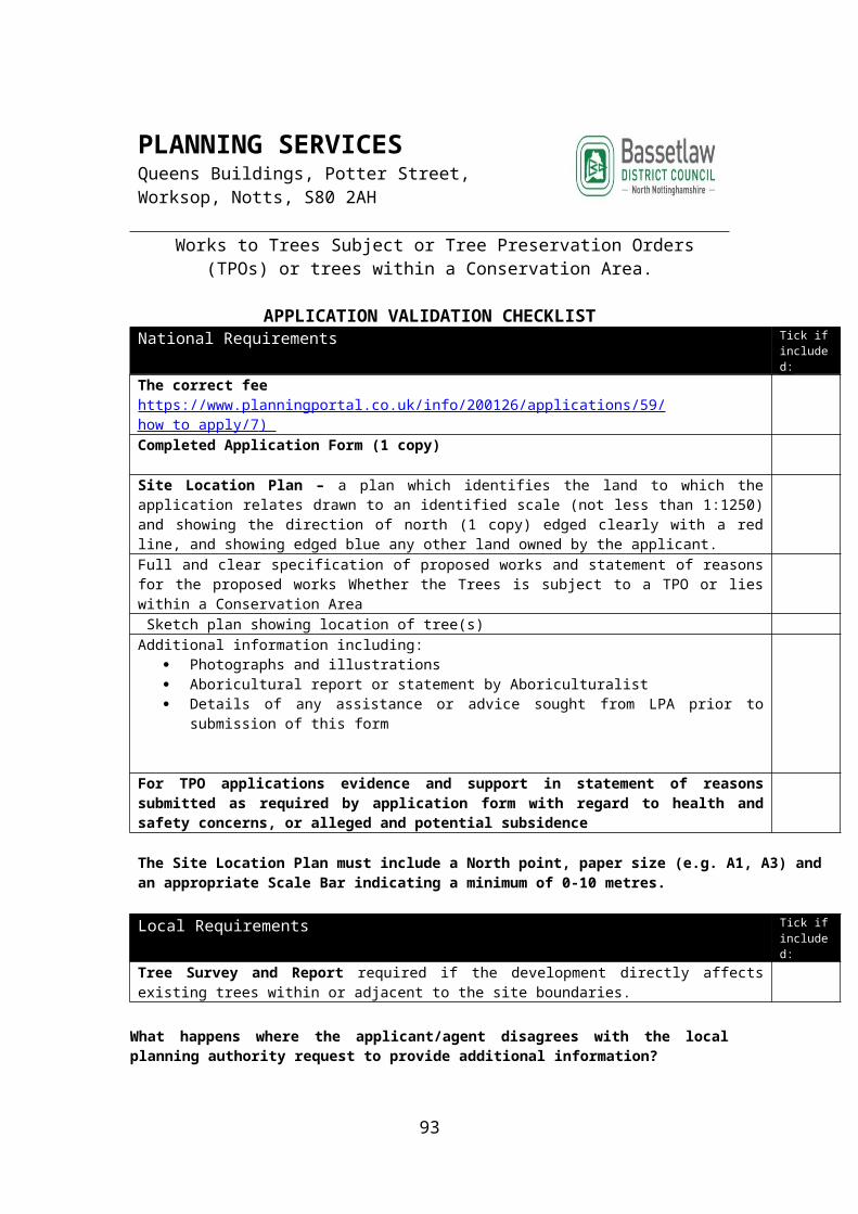
PLANNING SERVICES Queens Buildings, Potter Street, Worksop, Notts, S80 2AH
Form PN 6 - Application for Notification for Prior Approval for a Proposed Change of Use from an Agricultural Building and any land within its curtilage to a State-Funded School* or Registered Nursery** under Part 3, Class S of
the Town and Country Planning (General Permitted Development) Order 2015.
APPLICATION VALIDATION CHECKLIST
National Requirements Tick if included:
The correct feehttps://www.planningportal.co.uk/info/200126/applications/59/how_to_apply/7 ) Completed Application Form (1 copy)
Site Location Plan: A plan indicating the site and which buildings are to change use at a suggested scale of 1:1250A plan drawn to an identified scale will assist the authority in assessing your development proposalCumulative number of units proposed (including existing) a written description of the proposal which includes details of the likely transport and highways impact of the proposed change of useWhether the site is occupied under an agricultural tenancy agreement , whether both parties have consented to the change of use, whether that use has expired within the last year and whether an agricultural use is still required Cumulative floor area of the buildings to be converted and subject to a change of useThe use of the site at 20th March 2013 and if not in use when it was last in use Relevant information on noise, transport and highways impacts of the development and contamination and flooding risks on site. (A flood risk assessment should be provided with the application in Flood Zones 2 and 3, and in Flood Zone 1 where an area which has critical drainage problems has been notified to the Local Planning Authority by the Environment Agency)
All plans and drawings must include a North point, paper size (e.g. A1, A3)
*“state-funded school” means a school funded wholly or mainly from public funds including an Academy school, and alternative provision. Academy or a 16 to 19 Academy established under the Academies Act 2010, or a school maintained by a local authority as defined in section 142(1) of the School Standards and Framework Act 1998.**“registered nursery” means non-domestic premises in respect of which a person is registered under Part 3 of the Childcare Act 2006 to provide early years provision”
Does not apply whenDoes not apply where the building is a listed building, a scheduled monument or the site is, or forms part of, a safety hazard area or military explosives storage area.
This permitted development right is for the use of a building and land within its curtilage as a state-funded school or as a registered nursery and for no other purpose apart from purposes ancillary to those uses. A building qualifies for this permission only if it is currently used for a purpose falling within use class B1 (business), C1 (hotels), C2 (residential institutions), C2A (secure residential institutions) or D2 (assembly and leisure).
93

What happens where the applicant/agent disagrees with the local planning authority request to provide additional information?
There is a procedure in the Development Management Procedure Order to resolve such disputes. An applicant must first send the local planning authority a notice under article 12 of the Town and Country Planning (Development Management Procedure) (England) Order 2015 (an ’article 12 notice’). This must set out the reasons why the applicant considers that the information requested by the local planning authority, in refusing to validate the planning application, does not meet the statutory tests.
For internal use onlyValidation Checked by Date
94

7. Notification for Prior Approval of Proposed Change of Use of Agricultural Building to a flexible use within Shops, Financial and Professional services, Restaurants and Cafes, Business, Storage or Distribution, Hotels, or Assembly or Leisure
Does not apply where the building exceeds 500 square metres or is a Listed Building or Scheduled Ancient Monument or is or forms part of a safety hazard area or military explosives storage area.
95

PLANNING SERVICES Queens Buildings, Potter Street, Worksop, Notts, S80 2AH
Form PN 7 - Development consisting of a change of use of a building and any land within its curtilage from a use as an agricultural building to a flexible
use falling within Class A1 (shops), Class A2 (financial and professional services), Class A3 (restaurants and cafes), Class B1 (business), Class B8
(storage or distribution), Class C1 (hotels) or Class D2 (assembly and leisure) of the Schedule to the Use Classes Order under Part 3 Class R, of the Town
and Country Planning (General Permitted Development) Order 2015.
APPLICATION VALIDATION CHECKLIST
National Requirements Tick if included:
The correct feehttps://www.planningportal.co.uk/info/200126/applications/59/how_to_apply/7 ) Completed Application Form (1 copy)
A plan indicating the site and showing the proposed development. A plan drawn to an identified scale (suggested 1:100) will assist the authority in assessing your development proposalWhere the cumulative floor space of the building or buildings which have changed useunder Class R within an established agricultural unit does not exceed 150 square metres,provide the following information to the local planning authority—(i) the date the site will begin to be used for any of the flexible uses;(ii) the nature of the use or uses; and(iii) a plan indicating the site and which buildings have changed use;
Where the cumulative floor space of the building or buildings which have changed useunder Class R within an established agricultural unit exceeds 150 square metres, apply tothe local planning authority for a determination as to whether the prior approval of theauthority will be required as to—
Relevant information on noise, transport and highways impacts of the development
All plans and drawings must include a North point, paper size (e.g. A1, A3) and at a scale of 1:50 or 1:100 with a Scale Bar indicating a minimum of 0-10 metres.
Does not apply when (a) the building was not used solely for an agricultural use as part of an established agricultural unit—(i) on 3rd July 2012;(ii) in the case of a building which was in use before that date but was not in use on that date,when it was last in use, or(iii) in the case of a building which was brought into use after 3rd July 2012, for a period of atleast 10 years before the date development under Class R begins;(b) the cumulative floor space of buildings which have changed use under Class R within anestablished agricultural unit exceeds 500 square metres;(c) the site is, or forms part of, a military explosives storage area;(d) the site is, or forms part of, a safety hazard area; or(e) the building is a listed building or a scheduled monument.
96

Community Infrastructure Levy Administration Forms Tick if included:
The CIL Additional Information Form – to determine whether development is CIL liable if proposal seeks planning permission for development over 100 sq m (including residential extensions, new dwelling of an size, conversion/change of use of a building no longer in use).
What happens where the applicant/agent disagrees with the local planning authority request to provide additional information?
There is a procedure in the Development Management Procedure Order to resolve such disputes. An applicant must first send the local planning authority a notice under article 12 of the Town and Country Planning (Development Management Procedure) (England) Order 2015 (an ’article 12 notice’). This must set out the reasons why the applicant considers that the information requested by the local planning authority, in refusing to validate the planning application, does not meet the statutory tests.
For internal use onlyValidation Checked by Date
97

8. Notification for Prior Approval for a Change Of Use from Storage or Distribution Buildings (Class B8) and any land within its curtilage to Dwellinghouses (Class C3)
Does not apply for land within National Parks, Areas of Outstanding Natural Beauty, the Broads and World Heritage Sites, Listed Buildings or land within the curtilage of Listed Buildings, Scheduled Monuments, or in Sites of Special Scientific Interest, Safety Hazard Areas and Military Explosives Storage Areas and
Is limited to the change of use of a building (up to 500m2 of floor space) to a use falling within Class C3 (dwellinghouses) of the Schedule to the Use Classes Order from a use falling within Class B8 (storage or distribution buildings) of that Schedule and
After changing to a residential use, existing permitted development rights for dwelling houses (Class C3) will not apply.
98
PLANNING SERVICES Queens Buildings, Potter Street, Worksop, Notts, S80 2AH
Form PN 8 - Notification for Prior Approval for a Change Of Use from Storage or Distribution Buildings (Class B8) and any land within its curtilage to
Dwellinghouses (Class C3) Under Part 3, Class P of the Town and Country Planning (General Permitted Development) Order 2015.
APPLICATION VALIDATION CHECKLIST
National Requirements Tick if included:
The correct feehttps://www.planningportal.co.uk/info/200126/applications/59/how_to_apply/7 ) Completed Application Form (1 copy)
A plan indicating the site and which buildings are to change use.A plan drawn to an identified scale (suggested 1:100) will assist the authority in assessing your development proposalDescription of the proposed development, including relevant information covering transport and highways impacts of the development, air quality impacts on intended occupiers, noise impacts of the development, risks of contamination, flooding, and the impact the change of use would have on existing industrial uses and or storage or distribution uses:Gross floor area of existing and gross floor area subject to change of use Details of agricultural tenancy including consent of parties to change of useWas the use of the site use class B8 at 19th March 2014Has the use of the site been class B8 before the date development begins?
All plans and drawings must include a North point, paper size (e.g. A1, A3) If the questions relating to use are not fully known the LPA may require further information
Does not apply whenDoes not apply for land within National Parks, Areas of Outstanding Natural Beauty, the Broads and World Heritage Sites, Listed Buildings or land within the curtilage of Listed Buildings, Scheduled Monuments, or in Sites of Special Scientific Interest, Safety Hazard Areas and Military Explosives Storage Areas and
Is limited to the change of use of a building (up to 500m2 of floor space) to a use falling within Class C3 (dwellinghouses) of the Schedule to the Use Classes Order from a use falling within Class B8 (storage or distribution buildings) of that Schedule and
After changing to a residential use, existing permitted development rights for dwelling houses (Class C3) will not apply.
Community Infrastructure Levy Administration Forms Tick if included:
CIL Notice of Chargeable Development – It is the responsibility of the applicant/agent to serve a Notice of Chargeable Development to the Council prior to development commencing. The notice must be accompanied by a plan which identifies: the land to which the notice relates; any building that is relevant for the purposes of calculating the charge under regulation 40; the development which is subject of the notice. The CIL charge will then be calculated and applied.
99

What happens where the applicant/agent disagrees with the local planning authority request to provide additional information?
There is a procedure in the Development Management Procedure Order to resolve such disputes. An applicant must first send the local planning authority a notice under article 12 of the Town and Country Planning (Development Management Procedure) (England) Order 2015 (an ’article 12 notice’). This must set out the reasons why the applicant considers that the information requested by the local planning authority, in refusing to validate the planning application, does not meet the statutory tests.
For internal use onlyValidation Checked by Date
100

9. Notification for Prior Approval for a Change of Use from Amusement Arcades/Centres and Casinos, (Sui Generis Uses) and any land within its curtilage to Dwellinghouses (Class C3)
Does not apply to land within National Parks, Areas of Outstanding Natural Beauty, the Broads and World Heritage Sites for Listed Buildings or land within the curtilage of Listed Buildings, Scheduled Monuments, or in Sites of Special Scientific Interest, Safety Hazard Areas and Military Explosives Storage Areas
Development is allowed for a change of use of amusement arcades/centres and casinos (sui generis) of up to 150 m2 and after changing to a residential use, existing permitted development rights for dwelling houses (Class C3) will not apply.
101

PLANNING SERVICES Queens Buildings, Potter Street, Worksop, Notts, S80 2AH
Form PN 9 - Notification for Prior Approval for a Change of Use from Amusement Arcades/Centres and Casinos, (Sui Generis Uses) to any land
within its curtilage to Dwellinghouses (Class C3) under Part 3, Class N of the Town and Country Planning (General Permitted Development) Order 2015.
Householder Planning Application for planning permission for works or extension to a dwelling.
APPLICATION VALIDATION CHECKLIST
National Requirements Tick if included:
The correct feehttps://www.planningportal.co.uk/info/200126/applications/59/how_to_apply/7 ) Completed Application Form (1 copy)
A plan indicating the site and which buildings are to change use.Site Location Plan – a plan which identifies the land to which the application relates drawn to an identified scale (not less than 1:1250) and showing the direction of north (1 copy) edged clearly with a red line, and showing edged blue any other land owned by the applicant. A plan drawn to an identified scale (suggested 1:100) will assist the authority in assessing your development proposalDescription the proposed development, including relevant information covering transport and highways impacts of the development, contamination and flooding risks in relation to the buildingBlock Plan at a scale of 1:500 or 1:200 identifying the position of the development. The plan should include written dimensions of the development to the site boundaries and other existing buildings, access arrangements, public rights of way, position of trees, hard surfacing and boundary treatments.Floor Plans/Elevations necessary to fully describe the development ie Existing and proposed Floor Plans (at a scale of 1:50 or 1:100) to show the internal arrangement Existing and proposed Elevations (at a scale of 1:50 or 1:100) to show the external changesOwnership/Agricultural Holdings Certificate – completed section A, B, C or D as applicable and Agricultural Holdings Certificate Gross floor area of existing and gross floor area subject to change of use to residential Design and Access Statement (if your property is a listed building or in a conservation area and development is over 100 sq m or more)Whether any of the building or land within its curtilage been previously changed under Class N Amusement Arcades/Centres and Casinos, (Sui Generis Uses) to Dwelling-houses (Class C3)Heritage Asset Statement for extensions to a listed building or a building in a conservation area, registered park and garden, scheduled monument or a non-designated heritage asset (if not included as part of design and access statement) If Yes what was the total floorspace to residential?Gross floor area of existing and gross floor area subject to change of useWas the building and any land within its curtilage used solely as an amusement arcade/centre or casino on the 19th March 2014?If no, provide the date of when it was last in use solely as an amusement arcade/centre or casino:
All plans and drawings must include a North point, paper size (e.g. A1, A3) and at a scale of 1:50 or 1:100 with an appropriate Scale Bar indicating a minimum of 0-10 metres. If the questions relating to use are not fully known the LPA may require further information
Does not apply when Local Requirements Tick if
102

included:Does not apply to land within National Parks, Areas of Outstanding Natural Beauty, the Broads and World Heritage Sites for Listed Buildings or land within the curtilage of Listed Buildings, Scheduled Monuments, or in Sites of Special Scientific Interest, Safety Hazard Areas and Military Explosives Storage Areas
Development is allowed for a change of use of amusement arcades/centres and casinos (sui generis) of up to 150 m2 and after changing to a residential use, existing permitted development rights for dwelling houses (Class C3) will not apply.Protected Species (Biodiversity) Survey and Report required if there is a likelihood that protected species (particularly bats) will be affected. The need for a survey should be considered if the property is adjacent to a Site of Specific Interest, a Local Wildlife Site, a Local Nature Reserve or Ancient Woodland, a loft conversion is proposed.Flood Risk Assessment required if the property is located in a Flood Zone. For advice on flood risk fo to contact the Environment Agency website. (now Local Lead Flood Authority at Nottinghamshires County Council)Heritage Statement required if you will be erecting a building or enclosure in the grounds of a Listed Building, in a Conservation Area or is deemed to affect the setting of a Listed Building, scheduled monument or a non-designated heritage asset or you are undertaking excavations in an Archaeological Constraint area.Tree Survey and Report required if the development directly affects existing trees within or adjacent to the site boundaries.Community Infrastructure Levy Additional Information Form required for all applications for development of floor space (including residential extensions, for the creation of a new dwellings (of any size), or for the conversion of a new building no longer in use).Structural Survey required if development involves the re-use or conversion of outbuilding(s) or structure(s) in order to ensure that they are structurally sound and capable of conversion without significant alteration(s).
Other Documents Use the space below to list any other documents you are providing in support of your application:
Community Infrastructure Levy Administration Forms Tick if included:
CIL Notice of Chargeable Development – It is the responsibility of the applicant/agent to serve a Notice of Chargeable Development to the Council prior to development commencing. The notice must be accompanied by a plan which identifies: the land to which the notice relates; any building that is relevant for the purposes of calculating the charge under regulation 40; the development which is subject of the notice. The CIL charge will then be calculated and applied.
What happens where the applicant/agent disagrees with the local planning authority request to provide additional information?
103

There is a procedure in the Development Management Procedure Order to resolve such disputes. An applicant must first send the local planning authority a notice under article 12 of the Town and Country Planning (Development Management Procedure) (England) Order 2015 (an ’article 12 notice’). This must set out the reasons why the applicant considers that the information requested by the local planning authority, in refusing to validate the planning application, does not meet the statutory tests.
For internal use onlyValidation Checked by Date
104

10. Notification for Prior Approval for a Change of Use from Shops (Class A1), Financial and Professional Services (Class A2), Betting Offices, Pay Day Loan Shops and Casinos (Sui Generis Uses) to Restaurants and Cafés (Class A3)
Does not apply to Listed Buildings or for land within the curtilage of Listed Buildings or Scheduled Monuments, to Sites of Special Scientific Interest, Safety Hazard Areas and Military Explosives Storage Areas.
Development is allowed for a change of use of shops (Class A1), financial and professional services (Class A2), betting offices, pay day loan shops and casinos of up to 150m2 floor and for limited building works to allow the installation of extraction and ventilation units, and for waste storage and management.
Premises may revert from Class A3 use to their original use class if that was Class A1 (shops) or Class A2 (financial and professional services) under existing permitted development rights. A planning application will be required for change of use from Class A3 to a betting office or pay day loan shop.
105

PLANNING SERVICES Queens Buildings, Potter Street, Worksop, Notts, S80 2AH
Form PN 10 - Notification for Prior Approval for a Change of Use from Shops (Class A1), Financial and Professional Services (Class A2), Betting
Offices, Pay Day Loan Shops and Casinos (Sui Generis Uses) to Restaurants and Cafés (Class A3) under Part 3, Class C of the Town and Country
Planning (General Permitted Development) Order 2015.
APPLICATION VALIDATION CHECKLIST
National Requirements Tick if included:
The correct feehttps://www.planningportal.co.uk/info/200126/applications/59/how_to_apply/7 ) Completed Application Form (1 copy)
A plan indicating the site and which buildings are to change use.A plan drawn to an identified scale (suggested 1:100) will assist the authority in assessing your development proposalPlease describe the proposed development, including relevant information covering noise, odour, storage and handling waste, hours of opening and transport and highways impacts of the development. Where the building is located in a key shopping area, please provide details of any undesirable impact on the sustainability of that shopping area The gross floor space in square metres of the existing building?The floor space to be changed to assembly and leisure uses if different from the above? (square metres) Whether any of the building been previously changed under Class J Shops (Class A1) and Financial and Professional Services (Class A2), Betting Offices, Pay Day Loan Shops (Sui Generis Uses) to Assembly and Leisure Uses (Class D2)If Yes, what was the total floor space in square metres changed to Assembly and Leisure Uses?Was the building used solely as shops, financial and professional services, betting offices or pay day loan shops on 5th December 2013
All plans and drawings must include a North point, paper size (e.g. A1, A3) If the questions relating to use are not fully known the LPA may require further information
Does not apply whenDoes not apply to Listed Buildings or for land within the curtilage of Listed Buildings or Scheduled Monuments, to Sites of Special Scientific Interest, Safety Hazard Areas and Military Explosives Storage Areas.
Development is allowed for a change of use of shops (Class A1), financial and professional services (Class A2), betting offices, pay day loan shops and casinos of up to 150m2 floor and for limited building works to allow the installation of extraction and ventilation units, and for waste storage and management.
Premises may revert from Class A3 use to their original use class if that was Class A1 (shops) or Class A2 (financial and professional services) under existing permitted development rights. A planning application will be required for change of use from Class A3 to a betting office or pay day loan shop Development is not permitted in the case of a building that was brought into use after the 5th December 2013, for a period of at least 5 years before the date development under Class J begins.
106

Community Infrastructure Levy Administration Forms Tick if included:
CIL Notice of Chargeable Development – It is the responsibility of the applicant/agent to serve a Notice of Chargeable Development to the Council prior to development commencing. The notice must be accompanied by a plan which identifies: the land to which the notice relates; any building that is relevant for the purposes of calculating the charge under regulation 40; the development which is subject of the notice. The CIL charge will then be calculated and applied.
What happens where the applicant/agent disagrees with the local planning authority request to provide additional information?
There is a procedure in the Development Management Procedure Order to resolve such disputes. An applicant must first send the local planning authority a notice under article 12 of the Town and Country Planning (Development Management Procedure) (England) Order 2015 (an ’article 12 notice’). This must set out the reasons why the applicant considers that the information requested by the local planning authority, in refusing to validate the planning application, does not meet the statutory tests.
For internal use onlyValidation Checked by Date
107

11. Notification for Prior Approval for a Change of Use from Shops (Class A1) and Financial and Professional Services (Class A2), Betting Offices, Pay Day Loan Shops (Sui Generis Uses) to Assembly and Leisure Uses (Class D2)
Does not apply within conservation areas, National Parks, Areas of Outstanding Natural Beauty, the Broads and World Heritage sites nor for Listed Buildings and land within the curtilage of Listed buildings, Scheduled Monuments, Sites of Special Scientific Interest, Safety Hazard Areas or Military Explosives Storage Areas.
Development consisting of a change of use of shops (Class A1) and financial and professional services (Class A2), Betting Offices, Pay Day Loan Shops (Sui Generis Uses) with an upper threshold of 200 sqm. of total floor space to a use falling within Class D2 assembly and leisure uses of the Schedule to the Use Classes Order
Permitted development rights to convert a D2 premises to a registered nursery or state funded school do not apply to premises that change to D2 use under these rights.
108

PLANNING SERVICES Queens Buildings, Potter Street, Worksop, Notts, S80 2AH
Form PN 11 - Notification for Prior Approval for a Change of Use from Shops (Class A1), Financial and Professional Services (Class A2), Betting
Offices, Pay Day Loan Shops and Casinos (Sui Generis Uses) to Restaurants and Cafés (Class A3) under Part 3, Class C of the Town and Country
Planning (General Permitted Development) Order 2015.
APPLICATION VALIDATION CHECKLIST
National Requirements Tick if included:
The correct feehttps://www.planningportal.co.uk/info/200126/applications/59/how_to_apply/7 ) Completed Application Form (1 copy)
A plan indicating the site and which buildings are to change use.A plan drawn to an identified scale (suggested 1:100) will assist the authority in assessing your development proposalPlease describe the proposed development, including relevant information covering noise, odour, storage and handling waste, hours of opening and transport and highways impacts of the development. Where the building is located in a key shopping area, please provide details of any undesirable impact on the sustainability of that shopping area The gross floor space in square metres of the existing building?The floor space to be changed to assembly and leisure uses if different from the above? (square metres) Whether any of the building been previously changed under Class J Shops (Class A1) and Financial and Professional Services (Class A2), Betting Offices, Pay Day Loan Shops (Sui Generis Uses) to Assembly and Leisure Uses (Class D2)If Yes, what was the total floor space in square metres changed to Assembly and Leisure Uses?Was the building used solely as shops, financial and professional services, betting offices or pay day loan shops on 5th December 2013
All plans and drawings must include a North point, paper size (e.g. A1, A3) If the questions relating to use are not fully known the LPA may require further information
Does not apply whenDoes not apply to Listed Buildings or for land within the curtilage of Listed Buildings or Scheduled Monuments, to Sites of Special Scientific Interest, Safety Hazard Areas and Military Explosives Storage Areas.
Development is allowed for a change of use of shops (Class A1), financial and professional services (Class A2), betting offices, pay day loan shops and casinos of up to 150m2 floor and for limited building works to allow the installation of extraction and ventilation units, and for waste storage and management.
Premises may revert from Class A3 use to their original use class if that was Class A1 (shops) or Class A2 (financial and professional services) under existing permitted development rights. A planning application will be required for change of use from Class A3 to a betting office or pay day loan shop Development is not permitted in the case of a building that was brought into use after the 5th December 2013, for a period of at least 5 years before the date development under Class J begins.
109

Community Infrastructure Levy Administration Forms Tick if included:
CIL Notice of Chargeable Development – It is the responsibility of the applicant/agent to serve a Notice of Chargeable Development to the Council prior to development commencing. The notice must be accompanied by a plan which identifies: the land to which the notice relates; any building that is relevant for the purposes of calculating the charge under regulation 40; the development which is subject of the notice. The CIL charge will then be calculated and applied.
What happens where the applicant/agent disagrees with the local planning authority request to provide additional information?
There is a procedure in the Development Management Procedure Order to resolve such disputes. An applicant must first send the local planning authority a notice under article 12 of the Town and Country Planning (Development Management Procedure) (England) Order 2015 (an ’article 12 notice’). This must set out the reasons why the applicant considers that the information requested by the local planning authority, in refusing to validate the planning application, does not meet the statutory tests.
For internal use onlyValidation Checked by Date
110
12. Notification for Prior Approval for a Development Consisting of the Erection or Construction of a Collection Facility within the Curtilage of a Shop
Does not apply within conservation areas, National Parks, Areas of Outstanding Natural Beauty, the Broads and World Heritage Sites nor for land within the curtilage of Listed Buildings or Scheduled Monuments, or Sites of Special Scientific Interest.
The provision of a single click and collect facility within the curtilage of a shop, for example, on car parks. One facility per retail premises may be erected. Any buildings will be limited to 4 metres in height and a gross floor space of up to 20 sqm.
111

PLANNING SERVICES Queens Buildings, Potter Street, Worksop, Notts, S80 2AH
Form PN 12 - Notification for Prior Approval for a Development Consisting of the Erection or Construction of a Collection Facility within the Curtilage of a
Shop under Part 7, Class C of the Town and Country Planning (General Permitted Development) Order 2015.
APPLICATION VALIDATION CHECKLIST
National Requirements Tick if included:
The correct feehttps://www.planningportal.co.uk/info/200126/applications/59/how_to_apply/7 ) Completed Application Form (1 copy)
A plan indicating the site and which buildings are to change use at a suggested scale of 1:1250
A plan drawn to an identified scale (suggested 1:100) will assist the authority in assessing your development proposalPlease describe the proposed development, including relevant information covering the impact of development in respect of siting, design and external appearance of the new structure which must include details of any building operations proposedThe gross floor space in square metres of the proposed structure Details of the building or structure's position within the curtilage of the premises including distances from the boundaries Does not apply whenDoes not apply within conservation areas, National Parks, Areas of Outstanding Natural Beauty, the Broads and World Heritage Sites nor for land within the curtilage of Listed Buildings or Scheduled Monuments, or Sites of Special Scientific Interest.
The provision of a single click and collect facility within the curtilage of a shop, for example, on car parks. One facility per retail premises may be erected. Any buildings will be limited to 4 metres in height and a gross floor space of up to 20 sqm
Community Infrastructure Levy Administration Forms Tick if included:
CIL Notice of Chargeable Development – It is the responsibility of the applicant/agent to serve a Notice of Chargeable Development to the Council prior to development commencing. The notice must be accompanied by a plan which identifies: the land to which the notice relates; any building that is relevant for the purposes of calculating the charge under regulation 40; the development which is subject of the notice. The CIL charge will then be calculated and applied.
What happens where the applicant/agent disagrees with the local planning authority request to provide additional information?
There is a procedure in the Development Management Procedure Order to resolve such disputes. An applicant must first send the local planning authority a notice under article 12 of the Town and Country Planning (Development Management Procedure) (England) Order 2015 (an ’article 12 notice’). This must set out the reasons why the
112

applicant considers that the information requested by the local planning authority, in refusing to validate the planning application, does not meet the statutory tests.
For internal use onlyValidation Checked by Date
113

13. Notification for Prior Approval for the Temporary Use of Buildings or Land for the Purpose of Commercial Film-Making and the Associated Temporary Structures, Works, Plant
Does not apply in conservation areas, National Parks, Areas of Outstanding Natural Beauty, the Broads and World Heritage Sites nor to Listed Buildings or land within the curtilage of Listed Buildings, Scheduled Monuments, to Sites of Special Scientific Interest, Safety Hazard Areas or Military Explosives Storage Areas and
Development is not permitted on land which is more than 1.5 hectares or for overnight accommodation.
The new right allows the temporary use of any land or buildings for a period not exceeding 9 months in any 27 month period for the purpose of commercial film making and the provision on such land, during the filming period, of any temporary structures, works, plant or machinery required in connection with that use.
114

PLANNING SERVICES Queens Buildings, Potter Street, Worksop, Notts, S80 2AH
Form PN 13 - Notification for Prior Approval for the Temporary Use of Buildings or Land for the Purpose of Commercial Film-Making and the
Associated Temporary Structures, Works, Plant under Part 4 Class C of the Town and Country Planning (General Permitted Development) Order 2015
APPLICATION VALIDATION CHECKLIST
National Requirements Tick if included:
The correct feehttps://www.planningportal.co.uk/info/200126/applications/59/how_to_apply/7 ) Completed Application Form (1 copy)
A plan indicating the site and which buildings are to change use at a suggested scale of 1:1250A plan drawn to an identified scale (suggested 1:100) will assist the authority in assessing your development proposalThe application must be accompanied by—
(a) a written description of the proposed development;(b) the schedule of dates which make up the filming period in question and the hours of(c) operation,(d) transport and highways impacts of the development,(e) noise impacts of the development,(f) light impacts of the development, in particular the effect on any occupier of neighbouringland of any artificial lighting to be used, and
(g)a site-specific flood risk assessment
All plans and drawings must include a North point, paper size (e.g. A1, A3)
Does not apply whenDoes not apply in conservation areas, National Parks, Areas of Outstanding Natural Beauty, the Broads and World Heritage Sites nor to Listed Buildings or land within the curtilage of Listed Buildings, Scheduled Monuments, to Sites of Special Scientific Interest, Safety Hazard Areas or Military Explosives Storage Areas and
Development is not permitted on land which is more than 1.5 hectares or for overnight accommodation.
The new right allows the temporary use of any land or buildings for a period not exceeding 9 months in any 27 month period for the purpose of commercial film making and the provision on such land, during the filming period, of any temporary structures, works, plant or machinery required in connection with that use.
What happens where the applicant/agent disagrees with the local planning authority request to provide additional information?
There is a procedure in the Development Management Procedure Order to resolve such disputes. An applicant must first send the local planning authority a notice under article 12 of the Town and Country Planning (Development Management Procedure) (England) Order 2015 (an ’article 12 notice’). This must set out the reasons why the applicant considers that the information requested by the local planning authority, in refusing to validate the planning application, does not meet the statutory tests.
115

For internal use onlyValidation Checked by Date
116

14.Notification for Prior Approval for the Installation, Alteration or Replacement of other Solar Photovoltaics (PV) equipment on the Roofs of Non-domestic Buildings, up to a Capacity of 1 Megawatt
Does not apply for any roof slope which fronts a highway in conservation areas, National Parks, Areas of Outstanding Natural Beauty, the Broads and World Heritage Sites, nor to Listed Buildings or on a building within the curtilage of a Listed Building or Scheduled Monuments.
117

PLANNING SERVICES Queens Buildings, Potter Street, Worksop, Notts, S80 2AH
Form PN 14 - Notification for Prior Approval for the Installation, Alteration or Replacement of other Solar Photovoltaics (PV) equipment on the Roofs of Non-domestic Buildings, up to a Capacity of 1 Megawatt, subject to certain
limitations under Part 14, Class J of the Town and Country Planning (General Permitted Development) Order 2015.
APPLICATION VALIDATION CHECKLIST
National Requirements Tick if included:
The correct feehttps://www.planningportal.co.uk/info/200126/applications/59/how_to_apply/7 ) Completed Application Form (1 copy)
A plan indicating the site and which buildings are to change use at a suggested scale of 1:1250A plan drawn to an identified scale (suggested 1:100) will assist the authority in assessing your development proposalPlease describe the proposed development, including relevant information covering the design and external appearance, in particular the impact of the glare on occupiers of neighbouring landWhether the solar PV equipment will be installed on a flat roofThe degree of protrusion beyond the plane of the roof (Measured from the perpendicular with the external surface of the roof slope)The highest part of the solar PV equipment in metres above the highest part of the roof? (excluding any chimney)The distance from the solar PV equipment to the external edge of the roof
All plans and drawings must include a North point, paper size (e.g. A1, A3)
Does not apply whenDoes not apply for any roof slope which fronts a highway in conservation areas, National Parks, Areas of Outstanding Natural Beauty, the Broads and World Heritage Sites, nor to Listed Buildings or on a building within the curtilage of a Listed Building or Scheduled Monuments
What happens where the applicant/agent disagrees with the local planning authority request to provide additional information?
There is a procedure in the Development Management Procedure Order to resolve such disputes. An applicant must first send the local planning authority a notice under article 12 of the Town and Country Planning (Development Management Procedure) (England) Order 2015 (an ’article 12 notice’). This must set out the reasons why the applicant considers that the information requested by the local planning authority, in refusing to validate the planning application, does not meet the statutory tests.
For internal use onlyValidation Checked by Date
118

APPENDIX 1F: DEEMED DISCHARGE OF CONDITIONS NOTICE
Validation Checklist Receipt of Notification for Deemed Discharge of Conditions S29 of Infrastructure Act 2015 (inserting s74A into the Town and Country Planning Act 1990). Part 5 of the Town and Country Planning (Development Management Procedure (England) Order 1995
NATIONAL REQUIREMENTS ONLY
An application must be giving sufficient information to identify the permission; provide details of the application and identify the condition.
Include particulars, plans and drawings (as necessary) to deal with the application.
Application must be minimum of 6 weeks from date relevant planning application registered and confirm that no appeal has been lodged (if more than 8 weeks
The deemed discharge notice must Specify the date on which the deemed consent will take effect (either the 8 week date or 14 days after the notice is received, whichever is later unless an agreed later date has been agreed with the Local Planning Authority.
A plan identifying the buildings to which the application referred.
There is no fee for this notice
The type of conditions which are excepted from the deemed discharge procedure are set out in Schedule 6 of the and Country Planning (Development Management Procedure (England) Order 1995
Please note that the deemed consent provisions do not apply to all planning permissions or all types of conditions. The exemptions are set out in Article 30 and Schedule 6 of the DMPO.
119

PLANNING SERVICES Queens Buildings, Potter Street, Worksop, Notts, S80 2AH
Deemed Discharge of Conditions
APPLICATION VALIDATION CHECKLISTNational Requirements Only Tick if
included:The is no fee for this notice
Completed Application Form (1 copy)
An application must be giving sufficient information to identify the permission; provide details of the application and identify the condition.Include particulars, plans and drawings (as necessary) to deal with the application.Application must be minimum of 6 weeks from date relevant planning application registered and confirm that no appeal has been lodged (if more than 8 weeksSite Location Plan: Identifying the buildings/land to which the application referred Suggested Scales 1: 500 or 1:1250 or 1:2500 whatever is considered more appropriateThe type of conditions which are excepted from the deemed discharge procedure are set out in Schedule 6 of the and Country Planning (Development Management Procedure (England) Order 1995
All plans and drawings must include a North point, paper size (e.g. A1, A3) and an appropriate Scale Bar indicating a minimum of 0-10 metres.
You are strongly recommended to speak to the Local Planning Authority Prior to service of such a Notice
For internal use onlyValidation Checked by Date
Bassetlaw District Council’s preferred method for receiving applications electronic using the Planning Portal website (www.planningportal.co.uk)
120

APPENDIX 2: VALIDATION REQUIREMENTS: THE PLANNING APPLICATION SUITE
VALIDATION CHECKLIST (Appendix 1a-1b) Householder, Full, Outline, Listed Building, Advertisement Consent and Lawful Development Certificates)
N=National Requirement L= Local requirement G= See Guidance Blank=not required
Doc
umen
t
Sca
le
All
Hou
seho
lder
Full
Pla
nnin
g P
erm
issi
on
Full
Pla
nnin
g P
erm
issi
on a
nd
LB C
onse
nt
Pla
nnin
g P
erm
issi
on
Adv
ertis
emen
t C
onse
nt
Out
line
Pla
nnin
g P
erm
issi
on
List
ed B
uild
ing
Con
sent
Adv
ertis
emen
t C
onse
nt
LDC
: Exi
stin
g
LDC
: Pro
pose
d
LDC
: Lis
ted
Bui
ldin
g
Application Form N N N N N N N N NOwnership Cert N N N N N N GAgric Holding Cert
N N N N N N
Site Location Plan
1:1250 or1:2500 and North Direction
N N N N N N N N N G
Site Plan 1:500 or1:200 and North Direction
N N N N N N N L L G
Block Plan 1:200 L L L L L L L GApplication Fee N N N N N N N NDesign and Access Statement
G G L L L L G G
Existing and Proposed Floor Plans
1:100 or 1:50
L L L L L L L
Existing and Proposed Elevations
1:100 or 1:50
L L L L L L L
Existing and Proposed Roof Plans
1:100 or 1:50
L L L L L L L
Existing and Proposed Cross- Sections
1:100 or 1:50
L L L L L G
Existing and Proposed Floor Levels (OD)
G G G G G G G
Landscaping Details
1:500 or1:200
L L L L G
Existing and Proposed Boundary Treatments
1:500 or1:200
G G G G G G
Relationship to other buildings on site and adjoining sites
1:500 or1:200
G L L L L L G
Public Rights of Way on site and adjoining sites
1:500 or1:200
G G G G G G
Other See Additional Info List
G G G G G G G G G G
121

VALIDATION CHECKLIST (Appendix 1c) Applications under Prior Notifications Procedure)
N=National Requirement L= Local requirement G= See Guidance Blank=not requiredD
ocum
ent
Dem
oliti
on
Agr
icul
tura
l D
evel
opm
ent
Tel
e-C
omm
unic
atio
ns
Written Description of Development N N NPlan Showing Location N N NEvidence of erection of site notice NAppropriate Fee N N NOther G G N
VALIDATION CHECKLIST (Appendix 1d) Other Applications
N=National Requirement L= Local requirement G= See Guidance Blank=not required
Doc
umen
t
Sca
le
Hed
gero
w
Rem
oval
Wor
ks to
TP
O/A
CA
A
pplic
Var
iatio
n/R
emov
al o
f C
ondi
tion
S73
App
licat
ion
Non
-Mat
eria
l A
men
dmen
t
Dis
char
ge o
f C
ondi
tion(
s)
Application Form N N N N N NOwnership Cert NAgric Holding Cert NLocation Plan 1:1250 or
1:2500 and North Direction recommended
As left N
Plan Details G G GApplication Fee 1:200 N N N N NPreviously Approved Drawings
1:100 or 1:50 N
Specification of Works NTPO/CA Status of Trees
N
Details of Relevant condition(s)
N N
Other G G G N N N
122

VALIDATION CHECKLIST (Appendix 1e) Applications under Prior Approval Procedure) Numbered as in Guidance
N=National Requirement L= Local requirement G= See Guidance Blank=not requiredD
ocum
ent
1 2 3 4 5 6 7 8 9 10 11 12 13 14
Description of Development
N N N N N N N N N N N N N N
Site Plan Proposed Development
N N N N N N N N N N N N N N
Address of adjoining Properties
N
Flood Risk Appraisal
N N N N N N N
Land Contamination Risk Appraisal
N N N N N N N
Previous Use information
N N N N N N N N N N
Current Use Information
N N N N N N N N N N
Correct Fee N N N N N N N N N N N NAgricultural Tenancy Details
N N N
Noise, Transport, Highway Information
N N N N N
Other G G G G G G G G G G G G G G
VALIDATION CHECKLIST (Parts 3f) Notice for deemed discharge of conditions attached to grant of planning permission.
You are strongly recommended to speak to the Local Planning Authority Prior to service of such a Notice. Guidance is set out in Part 3F above.
123