what’s out there · ••presidio park ••w beech st presidio hills golf course ••...
TRANSCRIPT

The Cultural Landscape Foundation connecting people to places™
tclf.org
What’s Out There®
San Diego

3www.tclf.org2 The Cultural Landscape Foundation
Photo by Kelsey Kaline
San Diego Area
The Cultural Landscape Foundation (TCLF)TCLF is a 501(c)(3) non-profit founded in 1998 to connect people to places. TCLF educates and engages the public to make our shared landscape heritage more visible, identify its value, and empower its stewards. Through its website, publishing, lectures and other events, TCLF broadens support and understanding for cultural landscapes.
tclf.org
Welcome to What’s Out There® San Diego, organized by The Cultural Landscape Foundation (TCLF) and a committee of local experts.
This guidebook provides photographs and details of 34 examples of the region’s rich cultural landscape legacy. Its publication is timed to coincide with the launch of What’s Out There Weekend San Diego, October 26-27, 2019, a weekend of free, expert-led tours.
Inhabited by indigenous peoples for centuries before the first Europeans arrived, the region was occupied by Spanish colonists who established the Presidio of San Diego in 1776. The settlement remained relatively isolated until the United States annexed California in 1848. The introduction of the California Southern Railroad in 1885 transformed the Town of San Diego into a bustling port city. Philanthropists and civic leaders, including George Marston and Ellen Browning Scripps, invested in San Diego’s future as a sophisticated metropolis, contributing to such projects as City Park (now Balboa Park) and the Scripps Institution of Oceanography. Following World War II, a lengthy period of urban renewal projects revitalized downtown districts.
From the Torrey Pines State Natural Reserve to the University of California, San Diego, the region’s legacy of cultural landscapes includes sites of exceptional natural beauty and renowned design. Public spaces in the Picturesque tradition by Samuel Parsons, Jr., George Cooke, and horticulturist Kate Sessions live side-by-side with significant contemporary projects in various styles, not least among them the Salk Institute for Biological Studies by Louis Kahn and Roland Hoyt, and Horton Plaza by Jon Jerde and Wimmer Yamada & Associates.
This guidebook is a complement to TCLF’s digital What’s Out There San Diego guide (tclf.org/san-diego), an interactive
online platform that includes the enclosed site profiles plus
many others, as well as overarching narratives, maps, historic
photographs, and designers’ biographical profiles. The guide is
the seventeenth such online compendium of urban landscapes,
dovetailing with TCLF’s web-based What’s Out There, the
nation’s most comprehensive searchable database of historic
designed landscapes. Profusely illustrated and carefully
vetted, the searchable database currently features more than
2,000 sites, 12,000 images, and 1,100 designer profiles.
The database has been optimized for mobile devices and
includes What’s Nearby, a GPS-enabled feature that locates all
landscapes within a given distance, customizable by mileage or
walking time.
Local committee members Sharon Singleton, Amy Hoffman,
and Joy Lyndes gave considerable time and energy to this
project. A special word of thanks is owed to Kelsey Kaline,
who tirelessly researched and photographed many sites. We
are likewise grateful to the site owners, stewards, volunteers,
financial supporters, and other friends of TCLF who made
the guidebook and tours possible. We also appreciate your
interest in What’s Out There San Diego and hope you will enjoy
experiencing the region’s unique and valuable landscape legacy.
Sincerely,
Charles A. Birnbaum, FASLA, FAAR PRESIDENT AND CEO, THE CULTURAL LANDSCAPE FOUNDATION
5www.tclf.org4 The Cultural Landscape Foundation
SweetwaterReservoir
LowerOtay
Reservoir
San VicenteReservoir
LindoLake
Upper OtayReservoir
MiramarReservoir
SoledadLagoon
MurrayReservoir
Torrey PinesState Beach
Silver StrandState Beach
Cabrillo NationalMonument
San Diego River
San Diego River
Pacific Ocean
San Diego Bay
MissionBay
E L St
Friars Rd
South Ba
y Pky
Palm Ave
L St
La Jolla Village Dr
Ingraham St Grand Ave
Telegraph Canyon Rd
Campo Rd
Jamac
ha Blvd
Jama
cha R
d
Miramar Rd
Fletcher Pky
Balboa Ave
Otay Lakes Rd
Silver Strand Blvd
El Cajon Blvd
South
Bay Fwy
Miss
ion G
orge R
d San V
icente
Fwy
Scripps Poway Pky
G St
India St
Beryl St
30th
St
B St
28th
St
4th A
ve
Otay Fwy
Willow Rd
E 30th St
Logan Ave
Texa
s St
Harbor Dr
Ardath Rd
43rd
St
70th
St
E Palomar St
Picador Blvd
Florida Dr
Eucli
d Ave
Eucli
d Ave
Reo Dr
W Main St
E Orange AveOrange Ave
Federal Blvd
Gilm
an D
r
Willow Glen Dr
Home A
ve
Imperial Beach Blvd
Catal
ina Bl
vd
Avoc
ado B
lvd
Main St
Imperial Ave
Sea World Dr
H St
Avoc
ado A
ve
Conv
oy S
t
War
ing Rd
Carroll Rd
Los Coches Rd
Fanit
a Dr
Lemon
Grov
e Ave
National Ave
E Division St
Comm
unity
Rd
Euclid Ave
La Mesa Blvd
E St
N 2n
d St
Campo Rd
Palomar St
Sunse
t Cliffs
Blvd
Highland Ave
Pacific Hwy
Ruffin Rd
Skyline Dr
Nimitz Blvd
Mass
achu
setts
Ave
Hunte
Pky
E Chase Ave
Coronado Ave
Santo
Rd
Broadway
Fuerte Dr
Governor Dr
Sweetwater Rd
National City Blvd
54th
St
Mission Blvd
Jamacha Rd
5th A
ve
Wint
er Ga
rden
s Blvd
Montezuma Rd
Baltimore Dr
6th A
ve
Aero Dr
Pepper Dr
Swee
twate
r Rd
Rosec
rans S
t
Cam
ino R
uiz
Otay Lakes Rd
Sorrento
Valley Blvd
Broadway
Palm Ave
Park
Blvd
Banc
roft D
r
E Harbor Dr
La Jolla Blvd
Main St
Mast Blvd
Hilltop Dr
Paradise Valley Rd
Fairm
ount
Ave
E Main St
El Ca
mino
Rea
l
Bonita Rd
Beyer Blvd
Otay Mesa Rd
Broadway
4th Ave
Lind
a Vist
a Rd
Proc
tor
Valley Rd
Imperial Ave
Black Mountain Rd
Morena Blvd
Jackson Dr
N Torrey Pines Rd
Market St
Friars R
d
Mira Mesa Blvd
Kearn
y Villa
Rd
Poway Rd
E H St
Lake Murr
ay Bl
vd
Navajo Rd
Clairemont Mesa Blvd
Pomerado
Rd
N Harbor Dr
Genesee Ave
University Ave
Olympic P
ky
Otay FwyEscondido Fwy
Martin L
uther King Jr Fwy
Ted Williams Pky
Cabrillo
Fwy
John J Montgomery Fwy
San Diego Fwy
San Diego Fwy
San Diego Fwy
21
17
4
282
75
54
274
15
54
209
905
56
125
163
67
52
75
94
5
805
15
5
8805
5805
8
8
Spring Valley
Bonita
La Jolla
Coronado
Santee
Poway
National City
El Cajon
Imperial Beach
ChulaVista
Lemon Grove
La Mesa
Del Mar
San Diego
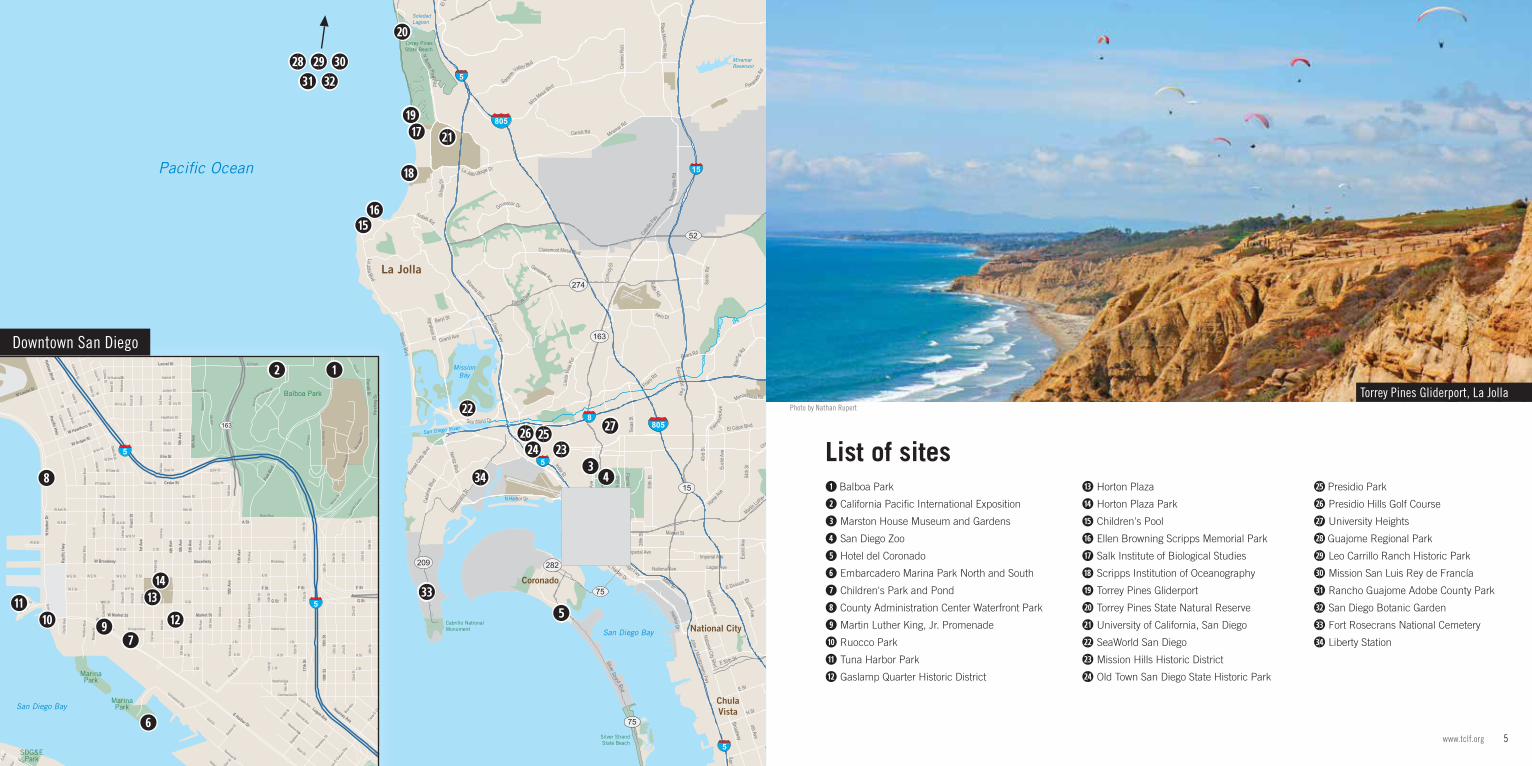
➊ Balboa Park
➋ California Pacific International Exposition
➌ Marston House Museum and Gardens
➍ San Diego Zoo
➎ Hotel del Coronado
➏ Embarcadero Marina Park North and South
➐ Children's Park and Pond
➑ County Administration Center Waterfront Park
➒ Martin Luther King, Jr. Promenade
➓ Ruocco Park
⓫ Tuna Harbor Park
⓬ Gaslamp Quarter Historic District
⓭ Horton Plaza
⓮ Horton Plaza Park
⓯ Children's Pool
⓰ Ellen Browning Scripps Memorial Park
⓱ Salk Institute of Biological Studies
⓲ Scripps Institution of Oceanography
⓳ Torrey Pines Gliderport
⓴ Torrey Pines State Natural Reserve
•• University of California, San Diego
•• SeaWorld San Diego
•• Mission Hills Historic District
•• Old Town San Diego State Historic Park
List of sites
Torrey Pines Gliderport, La Jolla
•• Presidio Park
•• Presidio Hills Golf Course
•• University Heights
•• Guajome Regional Park
•• Leo Carrillo Ranch Historic Park
•• Mission San Luis Rey de Francía
•• Rancho Guajome Adobe County Park
•• San Diego Botanic Garden
•• Fort Rosecrans National Cemetery
•• Liberty Station
Photo by Nathan Rupert
GoldenHillPark
GrantHillPark
Memorial ParkAnd
Recreation Center
SDG&EPark
MarinaPark
Balboa Park
MarinaParkSan Diego Bay
L St
F St
W Elm St
A St
W E St
K St
E St
Date St
Cedar St
15th
St
G Av
e
W E St
Marke
t Pl
Juniper Rd
Logan Ave
Colum
bia S
t
29th
St
W F St
F Ave
17th
St
28th
St
W
Water St Switzer S
t
Pueblo St
Pacif
ic Hw
y
W A St
F St
F St
Beard
sle
W Island Ave
17th
St
F St
L St
Minter D
r
E St
25th
St
Columbia St
Everett Ave
Valley Pl
Cesar E
Chavez
Pky
Grant Way
W E St
10th
Ave
G St
W
E St
Treat St
17th
St
Ka
lmia
Sicard
St
W Ivy St
19th
St
Glen
dale
Ave
Lang
ley S
t
Hoitt
St
2nd A
ve
29th
St
Date St
E St
Curlew St
Switzer S
t
Tuna Ln
W F St
Zoo Pl
W G St
Hens
ley S
t
Evan
s St
S 16th
St
Kalmia St
W Fir St
K St
Broadway Cir
J St
Laurel St
Cedar St
Bob W
ilson
Dr
29th
St
30th
St
4th A
ve
Dods
on S
t
W B St
W Ivy St Pan A
merican Rd W
Tony
Fir St
Hawthorn St
2nd A
ve
1st St
Grape St
Gull St
Elm St
11th
Ave
W C St
Grape St
Fir St
Hawthorn St
Kalmia St
Juniper St
Stitt
Ave
Ivy St
Date St
Cesar E
Chavez
Pky
20th
St
Terminal St
Juniper St
26th
St
W
K St
Wieber Ave
Sigsbe
e St
S 29
th St
W Date St
Beardsl
ey St
Ivy St
Franklin Ave
10th
Ave
B St
Franklin Ave
Cedar St
W A St
Beech St
Ash St
Webster Ave
W B St
6th A
ve
Union St
F St
W Kalmia St
Main St
16th
St
Kearney Ave
5th A
ve
Clay Ave
3rd A
ve
Bran
t St
Convention Way
Alba
tross
St
21st
St
Russ Blvd
8th Ave
Dewey
St
23rd
St
W Cedar St
G St
N Harbor Dr
Sampso
n St
27th
St
J St
24th
St
Cami
nito C
entro
W Beech St
S 30
th St
28th
St
Russ Blvd
W G St
25th
St
Imperial Ave
Fron
t St
California St
S Evans S
t
29th
St
1st A
ve
Beech St
G St
A St
Fron
t St
21st
St
20th
St
24th
St
26th
St
27th
St
30th
St
Balbo
a Dr
W Ash St Ash St
Newton Ave
Golden Hill Dr
1st A
ve
4th A
ve
Julian Ave
National Ave
13th
St
15th
St
16th
St
Gran
ada A
ve
McInt
ire D
r
Harrison Ave
E St
30th
St
Golf C
ourse
Irving Ave
El Prado
E St E St
12th
Ave
12th
Ave
Dale
StDa
le St
29th
St29
th St
Ocean View Blvd
B St
14th
St14
th St
A St A St
C St
Colum
bia S
t
2nd A
ve
Union
St
Union
St
22nd
St
22nd
St
9th A
ve9th
Ave
8th A
ve8th
Ave
Park Blvd
Park
Blvd
7th A
ve7th
Ave
L St L St L St
K St K St K St
C St C St
3rd A
ve3r
d Ave
3rd A
ve
J St J St J St
India
St
India St
India St
Broadway Broadway
Commercial StCommercial StCommercial St
State
St
State
St
State St
State St
Kettn
er B
lvdKe
ttner
Blvd
Kettn
er B
lvd
Kettner Blvd
Island Ave Island Ave Island Ave
A St
Kettner Blvd
30th
St
Cedar St
Fern
St
19th
St
Kearney Ave
Elm St
Laurel St
W Market St
Broadway
F StF St
G StG St
S 28
th S
t
25th
St
W Grape StW Hawthorn St
17th
St
Fern
St
BroadwayW Broadway
Fron
t St
Logan Ave
11th
Ave
10th
Ave
1st A
ve
26th St
Florida Dr
Pers
hing
DrW Laurel St
B St
28th
St
4th A
ve
W Harbor Dr
N Ha
rbor
Dr
Park
Blvd
E Harbor Dr
Imperial Ave
5th A
ve5t
h Ave
6th A
ve6t
h Ave
Pacif
ic Hw
y
Pacific Hwy
Market St Market St
F St
19th
St
Martin Luther King Jr Fwy
San Diego Fwy
163
94
5
5
Downtown San Diego
••
⓰ ⓯
⓳
⓮
••
➐
➊
••
⓱
➓
⓲
••
⓭
➌
••
➎
➑
••
➏
⓴
⓬
➋
••••
➒
⓫••
•• •••• ••
•• ➍

7www.tclf.org6 The Cultural Landscape Foundation
Photo by Charles A. BirnbaumLandscape Type:Public Park Large Municipal Park
Landscape Style:PicturesqueSpanish Colonial Revival
Designed By:T.S. Brandage CIVITAS George CookeMary B. Coulston Estrada Land PlanningHarland BartholomewKTUATakeshi “Ken” Nakajima John NolenSamuel Parsons, Jr.Spurlock Landscape ArchitectsKate Olivia SessionsTakeo Uesugi
In 1868 civic leaders set aside 1,400 acres of scrub-filled mesas and arroyos to become "City Park." Hired by George Marston, landscape architect Samuel Parsons, Jr., developed a Picturesque master plan in 1903. The design was realized by Parsons and his partner George Cooke, with the aid of horticulturists Kate Sessions and T.S. Brandage. City Park was renamed Balboa Park in anticipation of the 1915-1916 Panama-California Exposition, which was held in the park despite considerable public opposition. Architect Bertram Goodhue designed the exposition’s centerpiece, the House of Hospitality.
In 1921 a 140-acre zoo was built within the park, followed by the San Diego Museum of Art in 1926. Landscape architect John Nolen developed a second master plan for the park in 1927. One of more than a dozen horticultural resources in the park, the Alcazar Garden was designed in 1935 for the California Pacific International Exposition by architect Richard Requa. Harland Bartholomew Associates developed a new master plan in 1960, as did Estrada Land Planning in 1989. Further work has included the Palm Arboretum by KTUA and, in 2016, renovation plans for the Botanical Building by RNT Architects and Spurlock Landscape Architects. Balboa Park is home to fifteen museums and has been the site of three major expositions, including Expo 2000, San Diego’s millennium celebration. A cultural and horticultural oasis, the park is historically and topographically unique among large urban parks. The park’s former exposition grounds were designated a National Historic Landmark District in 1977.
Phot
o by
Cha
rles
A. B
irnba
um
Phot
o by
Kel
sey K
alin
e
Phot
o by
Cha
rles
A. B
irnba
um
Balboa Park
1549 El Prado Balboa ParkBalboa Park 1549 El Prado

9www.tclf.org8 The Cultural Landscape Foundation
Photo by Charles A. Birnbaum
Landscape Type:Exposition Grounds
Landscape Style:Beaux-Arts / NeoclassicalSpanish Colonial Revival (Hispano-Moorish)
Designed By:Bertram GoodhueJohn Morley Richard Requa
Related Landscapes:Balboa ParkAlcazar GardensCasa del Rey Moro GardenHouse of Hospitality Patio
Overlooking downtown San Diego, Balboa Park has evolved from its nineteenth-century beginnings as City Park through decades of new construction for fairs, including the Panama-California Exposition of 1915-1916 and the California Pacific International Exposition of 1935-1936.
The site for both expositions was situated on a mesa 300 feet above sea level, adjacent to Cabrillo Canyon on the eastern side of the park. Designed by Bertram Goodhue for the 1915-1916 exposition, the axial plan and many of the Spanish Colonial structures along the Prado, or central plaza, were repurposed for the 1935-1936 fair by supervising architect Richard Requa. Requa added the Palisades area, which illustrated the “architectural progression” from early Indian pueblos to Mayan and Aztec designs, to the latest in modern industrial architecture. He also designed several garden rooms inspired by Spanish and Mexican designs, including the Alcazar Gardens and the Casa del Rey Moro. The fair drew more than seven million visitors. Several buildings from both expositions, and some of Requa’s gardens, are still extant, including the Prado, the restored Casa del Rey Moro, and the reconstructed Alcazar Gardens. Managed by the City of San Diego, Balboa Park is the largest urban cultural park in the country. The exposition grounds were designated a National Historic Landmark District in 1977.
All photos this page by Charles A. Birnbaum
California Pacific International Exposition
El Prado Balboa ParkBalboa Park El Prado

11www.tclf.org10 The Cultural Landscape Foundation
Photo by Kelsey Kaline
Landscape Type:Garden and EstateCountry Place Era Garden
Landscape Style:Arts & CraftsPicturesque
Designed By:George Cooke Irving GillWilliam Sterling HebbardJohn Nolen Samuel Parson, Jr. Kate Olivia Sessions Hale Walker
Related Landscapes:Balboa Park
Contiguous with Balboa Park, this five-acre garden reflects a mixture of styles and influences. Originally laid out by George Cooke, the garden surrounds an Arts and Crafts-style home designed by William Hebbard and Irving Gill for the Marston family. Beginning in 1906, Cooke planted cedars, pines, and live oaks around a sweeping lawn that rolls down a hill south of the house. Horticulturist Kate Sessions, the “mother of Balboa Park,” advised on the original planting scheme. The Marstons added a hot house, a rose arbor, and a perimeter brick wall in the north garden, as well as cobble pathways that snake down the sloped eastern section of the property under a canopy of pine, eucalyptus, and oak trees. Landscape architect John Nolen, who created San Diego’s first urban plan, requested a young Thomas Church to draw up initial plans for an update to the garden in the late 1920s. Whether Church’s conceptual plan was subsequently followed is unclear. By 1928 Nolen’s associate Hale Walker took over the project and, with input from the family, designed the northern garden with colorful flower beds, a tile-decorated tea house adjacent to a green, a wall fountain, and a belvedere that overlooks the densely vegetated canyon below. The property was listed in the National Register of Historic Places in 1974 and was gifted to the City of San Diego in 1987.
All p
hoto
s th
is p
age
by K
else
y Kal
ine
Marston House Museum and Gardens
3525 Seventh Avenue Balboa ParkBalboa Park 3525 Seventh Avenue

13www.tclf.org12 The Cultural Landscape Foundation
Photo by Amanda Shull
Landscape Type:ZooContemporary Zoo
Landscape Style:Picturesque
Designed By:Charles FaustDeneen Powell AtelierEstrada Land PlanningLouis GillJohn MorleyJones & JonesKTUALloyd RuoccoNeri Landscape Architecture Nathanial E. Slaymaker
Located within Balboa Park, the zoo was established during the Panama-California International Exposition of 1916. The zoo was officially granted 140 acres by the city in 1921, with canyons, mesas, and other areas containing animal-specific cages, dens, and corrals. Landscape plans were supplied by landscape architect Nathaniel Slaymaker, while architect Louis Gill designed the zoo’s first buildings and cages. In 1955 Balboa Park’s original Japanese Tea House and Garden were dismantled to make room for the zoo’s expansion. Shortly afterwards, artist Charles Faust redesigned the zoo’s main exhibits to incorporate some of the world’s earliest moated, cageless enclosures. His exhibits were revolutionary in their approach to recreating natural animal habitats. The landscape architecture firm Jones & Jones created a new master plan in 1985 that reorganized the zoo into bioclimates that represent distinct plant and animal communities. In 2004 Estrada Land Planning amended the master plan, calling for the reorientation of the zoo’s entry and the conversion of a surface parking lot into zoological gardens and a greenbelt. Deneen Powell Atelier, Neri Landscape Architecture, and KTUA have also contributed to the design of various exhibits.
Within the Zoo’s current 100 acres, bioclimate zones ranging from desert to lush tropical areas are dotted with numerous exhibits and connected via meandering paths that conform to the site’s dramatic and complex topography. The approximately 700,000 plants located throughout the grounds form a dense, well-shaded botanical garden that is integrated with the animal exhibits.
All photos this page by Amanda Shull
San Diego Zoo
2920 Zoo Drive Balboa ParkBalboa Park 2920 Zoo Drive
15www.tclf.org14 The Cultural Landscape Foundation
Photo by Kelsey Kaline
Landscape Type:Courtyard
Landscape Style:Mediterranean
Designed By:Reid & ReidKate Olivia Sessions
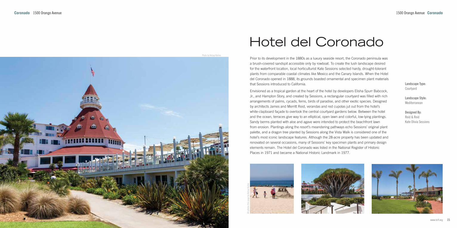
Prior to its development in the 1880s as a luxury seaside resort, the Coronado peninsula was a brush-covered sandspit accessible only by rowboat. To create the lush landscape desired for the waterfront location, local horticulturist Kate Sessions selected hardy, drought-tolerant plants from comparable coastal climates like Mexico and the Canary Islands. When the Hotel del Coronado opened in 1888, its grounds boasted ornamental and specimen plant materials that Sessions introduced to California.
Envisioned as a tropical garden at the heart of the hotel by developers Elisha Spurr Babcock, Jr., and Hampton Story, and created by Sessions, a rectangular courtyard was filled with rich arrangements of palms, cycads, ferns, birds of paradise, and other exotic species. Designed by architects James and Merritt Reid, verandas and red cupolas jut out from the hotel’s white-clapboard façade to overlook the central courtyard gardens below. Between the hotel and the ocean, terraces give way to an elliptical, open lawn and colorful, low-lying plantings. Sandy berms planted with aloe and agave were intended to protect the beachfront lawn from erosion. Plantings along the resort’s meandering pathways echo Sessions’ original plant palette, and a dragon tree planted by Sessions along the Vista Walk is considered one of the hotel’s most iconic landscape features. Although the 28-acre property has been updated and renovated on several occasions, many of Sessions’ key specimen plants and primary design elements remain. The Hotel del Coronado was listed in the National Register of Historic Places in 1971 and became a National Historic Landmark in 1977.
All p
hoto
s th
is p
age
by K
else
y Kal
ine
Hotel del Coronado
1500 Orange Avenue CoronadoCoronado 1500 Orange Avenue

17www.tclf.org16 The Cultural Landscape Foundation
Photo by Kelsey Kaline
400 Kettner Boulevard Downtown
Landscape Type:Public ParkNeighborhood Park Waterfront Development
Landscape Style:Modernist
Designed By:Joseph Y. Yamada Wimmer Yamada & Associates
Located on the peninsula of San Diego Bay, this pair of parks were commissioned in 1976 under the leadership of San Diego port commissioner Bernice Leyton. Formed from the dredging of the bay’s shipping channels, the parks were designed by the landscape architecture firm Wimmer Yamada & Associates and completed in 1978. Connected via the South Embarcadero promenade, the two parks extend into the bay, sheltering the Embarcadero Marina. Both are lined by riprap and consist of open lawns with gently rolling mounds no more than three feet high. The undulating turf of the parks is interspersed with groves of eucalyptus and coral trees that diminish the impact of western winds.
The 9.5-acre Embarcadero Marina Park North was planned as an extension of the north bordering Sea Port Village, also designed by Joseph Yamada in 1978. A circuitous path loops through the middle of an open lawn, providing a sweeping view of the Coronado bridge and downtown San Diego. The pedestrian circulation network leads to a small plaza that overhangs the water. Shade is offered by a series of wood-and-concrete pergolas and several gazebos. Across the marina, the thirteen-acre Embarcadero Marina Park South is bisected by Marina Parkway, culminating in a large parking area that extends the length of the park and leads to a T-shaped fishing pier. North of the parking lot is a three-acre oval lawn, while to the south is a cement basketball court adjoined by an elevated gazebo.
Embarcadero Marina Park North and South
Downtown 400 Kettner Boulevard
All photos this page by Kelsey Kaline

19www.tclf.org18 The Cultural Landscape Foundation
Photo by Kelsey Kaline
Landscape Type:Public Park
Landscape Style:Postmodernist
Designed By:The Office of Peter Walker and Martha SchwartzSchmidt Design Group Spurlock Landscape ArchitectsMartha Schwartz Peter Walker
Related Landscapes:Martin Luther King, Jr. Promenade
The result of a design competition for Marina Linear Park (now Martin Luther King, Jr. Promenade) won by the Office of Peter Walker and Martha Schwartz in 1987, this 2.1-acre park adjacent to the promenade’s midpoint was implemented by successor firm Peter Walker William Johnson and Partners. Although the completed promenade did not debut until 1997, Children’s Park and Pond opened in July 1995 in anticipation of the 1996 Republican National Convention in San Diego.
Equidistant from Seaport Village to the west and the Gaslamp Quarter to the east, the park is divided into two sections. A geometrically planted pine grove extends north from a 200-foot-diameter, circular pool. Bordered by Mexican fan palms, the fourteen-inch-deep pool is bisected by the promenade and the Santa Fe Railroad. Two lines of rectangular stone slabs meet at a right angle within the pool, with one line passing through a spray fountain comprising a grid of steel poles. Crossing into the grove, the stone slabs link the park’s aquatic and terrestrial halves. The park’s shaded grove of Canary Island pines contained a prominent array of grass mounds, which were removed between 2008 and 2016. The mounds were replaced with flat, circular grass beds that were later filled with gravel, creating a uniform ground plane. The concrete rings that once encircled the mounds were retained. The grove is lined by palm trees and edged on two sides by a cypress allée and a path with a striped paving pattern.
All p
hoto
s th
is p
age
by K
else
y Kal
ine
Children's Park and Pond
326 West Harbor Drive DowntownDowntown 326 West Harbor Drive

21www.tclf.org20 The Cultural Landscape Foundation
Photo by Kelsey Kaline
Landscape Type:Institutional GroundsPublic ParkNeighborhood Park
Landscape Style:Beaux-Arts / Neoclassical
Designed By:Hargreaves AssociatesRoland Hoyt John Nolen Schmidt Design Group
Built in 1938 on infilled tidelands, the San Diego Civic Center (now County Administration Center, or CAC) partially realized landscape architect and city planner John Nolen’s 1908 vision for a downtown waterfront core. With funding from the Works Progress Administration, landscape architect Roland Hoyt laid out the Beaux-Arts East Courtyard, a western plaza, and perimeter gardens planted with palm and tea trees. A section of the grounds was replanted as a victory garden during World War II, and as a water conservation garden in the 1960s. In 2014 the landscape was redesigned by Hargreaves Associates and Schmidt Design Group.
Bordered on three sides by rows of coast live oaks, the twelve-acre linear park contains a playground, an open lawn that makes up the western half of the park, and two wading pools that extend from the north and south sides of the CAC building. A playground and bocce ball court are located above an underground parking structure to the south, while the northeast section contains drought-tolerant gardens, winding pathways, and sculptures. Significant portions of the 1939 landscape remain, namely the East Courtyard and plaza directly west of the CAC. Facing San Diego Bay, the western plaza features the granite Guardian of Water (1939) statue by local artist Donal Hord, situated within a circular basin, six groupings of Senegal palm trees, and a panoramic view of an active waterfront. Shaded by trees, the formal entrance courtyard is bookended by two round fountains. The CAC was added to the National Register of Historic Places in 1988.
Photo by Kelsey Kaline
Photo by Kelsey Kaline
Photo by Charles A. Birnbaum
County Administration Center Waterfront Park
1600 Pacific Highway DowntownDowntown 1600 Pacific Highway

23www.tclf.org22 The Cultural Landscape Foundation
Photo by Kelsey Kaline
Landscape Type:Commemorative LandscapePublic Park
Landscape Style:Postmodernist
Designed By:The Office of Peter Walker and Martha SchwartzMartha Schwartz Peter WalkerPeter Walker William Johnson and Partners
Related Landscapes:Children’s Park and Pond
Originally called Marina Linear Park, the twelve-acre park originated with a competition won by the Office of Peter Walker and Martha Schwartz in 1987. Dedicated as Martin Luther King, Jr. Promenade in 1992, the park was implemented by successor firm Peter Walker William Johnson and Partners and opened to the public in 1997.
Adjacent to the active Santa Fe Rail and San Diego Trolley corridor, the 0.6-mile-long linear park begins in the Gaslamp Quarter and extends past the San Diego Convention Center to the Marina District. Palm and poplar allées with circular mounds of ice plants separate Harbor Drive from the railway, and two flat pedestrian pathways run along both sides of the tracks. The northern path is lined with 30 plaques engraved with Dr. King’s words. The park is dotted with outdoor sculptures, including Breaking of the Chains by Melvin Edwards, installed in 1995, and several others added in 2001, with one placed in the middle of a hedge maze near the park’s northwestern end. At the center of the promenade, between Front Street and First Avenue, is a 200-foot-wide, circular reflecting pool. The shallow pool is studded with a small grid of ten-foot-tall, steel sprinkler poles and contains two rows of rectangular stone slabs that meet at a right angle. Used as steppingstones to access the pool, the slabs extend into the pine grove of the Children’s Park beyond, part of the initial design competition and likewise implemented by Peter Walker William Johnson and Partners in 1995.
All p
hoto
s th
is p
age
by K
else
y Kal
ine
Martin Luther King, Jr. Promenade
326 West Harbor Drive DowntownDowntown 326 West Harbor Drive

25www.tclf.org24 The Cultural Landscape Foundation
Landscape Type:Public ParkNeighborhood ParkWaterfront Development
Designed By:Dennis OtsujiONA Associates
Positioned between Seaport Village and Tuna Harbor, this 3.3-acre park overlooks San Diego Bay and Coronado Island. Work was completed in 2012 by ONA Associates, which has since merged with the firm Wimmer Yamada and Caughey. Previously a restaurant and parking lot on port-controlled land, the park honors Lloyd and Ilse Ruocco, who established a fund for a public park beginning in 1977. Lloyd Ruocco was a prominent local Modernist architect, and his wife, Ilse, an interior designer and professor.
Located at the busy intersection of West Harbor Drive and the Pacific Highway, the entrance to the park is a half-acre plaza featuring a 45-foot-high sculpture by Roman de Salvo consisting of suspended eucalyptus branches that are sliced lengthwise. Named The Riparium (2012) and built to suggest a sailboat’s mast and rigging, the sculpture keeps the ground plane open and allows visitors to pass under an ever-changing web of shadows into the park beyond. Pedestrian circulation consists of a perimeter loop around a large oval lawn bordered by sweetshade and shoestring acacia trees. Other plantings include fern pines in the northwest corner and drought-tolerant xeriscape gardens at the northern and southern borders. A separate picnic lawn is dotted with shade trees and circular concrete islands, each one containing a picnic bench. Interspersed with planting areas, stones, and benches, a paved oval plaza at the park’s western end opens onto the Embarcadero.
Photo by Charles A. Birnbaum
Photo by Kelsey Kaline Phot
o by
Min
g-ye
n Hs
u
Phot
o by
Kel
sey K
alin
e
Phot
o by
SD
Dirk
Landscape Type:Public ParkNeighborhood Park Waterfront Development
Designed By:KTUAWimmer Yamada and Caughey
Formerly known as the G Street Mole, Tuna Harbor Park extends into San Diego Bay between the Navy Supply Pier and Seaport Village. Originally built as part of the city’s coal wharf, the Mole served as an important naval fleet landing site until the mid-twentieth century, when it evolved into a hub for commercial tuna fishing. Following the decline of San Diego’s fishery business in the postwar era, most of the park’s current site was left vacant until the late 1980s.
Through a series of waterfront memorials and interpretive signage connected by concrete paths, the park honors the tuna industry’s contributions to San Diego, as well as the city’s significant historic and ongoing naval presence. A pedestrian pathway known as the “Greatest Generation Walk” connects multiple memorials and art installations dedicated to World War II. The park’s northern half parallels the Embarcadero’s wooden esplanade and pier, moving from the USS Midway Museum through a swath of shady lawn dotted with naval aircraft memorials. At G Street, the eastern section of the park juts into the bay atop the riprap-lined mole. The park contains several memorials and commemorative plazas, including one designed by Wimmer Yamada and Caughey in 2013 to hold the Unconditional Surrender (also known as “Victory Kiss”) sculpture by Seward Johnson, depicting the famous Times Square embrace between a sailor and a woman following the surrender of Japan. An elevated, circular plaza at the park’s eastern corner provides sweeping views of the USS Midway and San Diego Bay.
Photo by Kelsey Kaline
Tuna Harbor ParkRuocco Park
3 Tuna Lane DowntownDowntown 585 Harbor Lane

27www.tclf.org26 The Cultural Landscape Foundation
Photo by Kelsey Kaline
Designed By:Donald AppleyardKawasaki/Theilacker & AssociatesKevin LynchROMA Design GroupWimmer Yamada & Associates
Related Landscapes:Horton PlazaHorton Plaza Park
Located near the waterfront, this downtown district housed saloons, gambling halls, and brothels until mass evictions and condemnation circa 1915. After World War II, residents and commerce fled to the suburbs, and the district largely deteriorated. In 1974 the Marston family underwrote a study by urban planners Kevin Lynch and Donald Appleyard that proposed revitalizing the district. That same year, ROMA Design Group created a development plan in preparation for the construction of the six-block Horton Plaza Mall, and Kawasaki/Theilacker & Associates (now KTUA) created a master plan for the district in 1978. Throughout the 1980s, the city applied adaptive-reuse techniques to restore and preserve existing structures, transforming the area into the “Historic Heart of San Diego.” Various streetscape improvements by landscape architecture firms Wimmer Yamada & Associates and Kawasaki/Theilacker & Associates helped tie the district to nearby neighborhoods. The district’s turn-of-the-century commercial streetscape is coupled with large-scale development from the 1980s and thereafter. Spaces between buildings are common, creating frequent internal alleys and arcades. Streetscape improvements included widening brick-paved sidewalks, installing five-globed light fixtures, and lining the roads with eucalyptus trees. An illuminated archway spans Fifth Avenue and acts as the district’s formal entrance. Horton Plaza Park, an historic neoclassical green renovated and expanded in 2016, is located at the district's northern edge. The Gaslamp Quarter Historic District was added to the National Register of Historic Places in 1980.
All photos this page by Kelsey Kaline
Gaslamp Quarter Historic District
Gaslamp QuarterGaslamp Quarter

29www.tclf.org28 The Cultural Landscape Foundation
Landscape Type:Shopping CenterShopping Plazas / Shopping Malls
Landscape Style:Postmodernist
Designed By:Jon JerdeJoseph Y. YamadaWimmer Yamada & Associates
Related Landscapes:Gaslamp Quarter Historic District
As part of urban renewal efforts begun in the 1970s, the area that would become the shopping center was subject to a study by well-known urban planners Kevin Lynch and Donald Appleyard, along with a development plan by San Francisco-based ROMA Design Group, both in 1974. Encompassing 6.5 city blocks, Horton Plaza opened in 1985. Architect Jon Jerde, envisioning Horton Plaza as a “festival marketplace,” enlisted Wimmer Yamada & Associates to design the paving patterns and various site furnishings. The large urban mall with an open-air courtyard was noted for its isolation from the surrounding urban fabric and for its immediate popularity, catalyzing the creation of similar downtown entertainment districts nationwide.
The main entrance, on Broadway Circle, comprises several arcades that open onto the galleria, where five stories of multicolored walls and balcony-lined walkways meet at various angles above the central courtyard. Inspired by vernacular streets in Italian hillside towns, narrow walkways, dead ends, and sudden turns characterize the mall’s pedestrian experience. Exaggerated and abstracted versions of traditional architectural forms, such as domes, parapets, piazzas, and terraces, also appear throughout the mall. Stacked paths and overlooks converge inside a triangular, four-story, black-and-white-tiled loggia. Other major elements scattered throughout the site include a faux bell tower, a Siena Cathedral-inspired dome, and a Joan Brown-designed mosaic obelisk marking the Broadway Circle entrance. In 2019 the City of San Diego approved redeveloping the mall as a mixed-use complex.
Phot
o by
Cha
rles
A. B
irnba
um
Phot
o by
Kel
sey K
alin
e
Phot
o by
Kel
sey K
alin
e
Landscape Type:PlazaPublic ParkGreens / Commons / Squares
Designed By:Irving Gill Walker Macy Kate Olivia SessionsSchmidt Design Group
Related Landscapes:Gaslamp Quarter Historic District
Originally known as “the town plaza,” this 1.8-acre downtown park has been in use since 1870 when real estate developer Alonzo Horton cleared land around his hotel for public gatherings. Horton deeded the land to the city in 1895, two years before Kate Sessions planted palm trees in the small fenced-in park. In 1910 Irving Gill designed new walkways and created the Broadway Fountain modeled on the Choragic Monument of Lysicrates in Athens, Greece. After being restored by the city in 1978, the plaza was the subject of a plan developed by landscape architect Lawrence Halprin in 1984 in anticipation of the opening of the Horton Plaza shopping mall. Halprin’s design was never implemented, and the park remained unchanged until the 2010s. Designed by landscape architecture firm Walker Macy, a 1.4-acre expansion to the south opened in 2016.
Centered around the restored Broadway Fountain, the original parcel consists of equally sized lawn panels cut through by linear paths and lined with neoclassical urns. Measuring just 0.4 acres, this historic core is separated from the surrounding streets and the park addition to the south by an allée of palm trees. Curving through the middle of the expanded park, an amphitheater with stepped seating divides the space into upper and lower levels. In the lower section, a small plaza opens to a south-facing entrance. Three pavilions with trellised overhangs are spaced on the edges of the amphitheater, along with eight light sculptures. In 2017 a plaque commemorating Jefferson Davis was removed by city officials.
All photos this page by Kelsey Kaline
Horton Plaza ParkHorton Plaza
900 Fourth Avenue Gaslamp QuarterGaslamp Quarter 324 Horton Plaza

31www.tclf.org30 The Cultural Landscape Foundation
Landscape Type:Public ParkNeighborhood Park
Designed By:William Templeton JohnsonHiram Savage
Located below bluffs at the northern edge of La Jolla, this two-acre recreational site was originally underwritten by local philanthropist Ellen Browning Scripps. Concerned that the La Jolla community’s children did not have a safe place to swim, Scripps hired engineer Hiram Savage to survey the coast for a place to build a barrier to shield adolescent swimmers from dangerous crosscurrents. A popular beach adjacent to the La Jolla Park subdivision was chosen, and Savage, working with architect William Johnson, designed an arcing, 300-foot-long concrete breakwater. To offer a respite to tired swimmers, Savage and Johnson built a series of steps into the inner portion of the breakwater. The site was deeded to the city in 1931.
The core of the site consists of a horseshoe-shaped cove situated beneath coastal bluffs. An observation walkway skirts an adjoining plaza (opened in 2018). Surrounded by an iron balustrade, the walkway continues to the top of the curved breakwater. Descending 25 feet from a wide belvedere that overlooks the ocean, a divided staircase with two flights opposite each other connects the plaza to the beach. Adjacent to the top level of the staircase, a two-story lifeguard station, built in 2016, replaced an earlier iteration. A wooden gazebo sits atop a rocky outcrop to the east. Due to the calm water, the beach has become a haven for harbor seals, and the tidal pool is closed during pup-birthing season.
Photo by Kelsey Kaline
Photo by Kevin Baird All p
hoto
s th
is p
age
by C
ultiv
ar 4
13
Landscape Type:Public ParkNeighborhood Park
Landscape Style:Samuel Parsons, Jr.
Overlooking the Pacific Ocean, this 5.6-acre park was part of the plans for La Jolla Park, a coastal village developed by speculators Frank Botsford and George Heald in 1886. Inspired by the nineteenth-century City Beautiful movement, the two men set aside a segment of land adjacent to the La Jolla Cove for use as a public park. The development of the park was partially guided by landscape architect Samuel Parsons, Jr., who encouraged the planting of salt-resistant flora, including the site’s iconic cypress tree groves. Known alternatively as La Jolla Park and La Jolla Shoreline Park, the landscape was renamed Ellen Browning Scripps Park in 1927 in honor of the local journalist and philanthropist.
Located thirteen miles northwest of downtown San Diego, the park comprises a 3.8-acre lawn elevated more than twelve feet above three separate beaches. Commencing at the La Jolla Cove and extending westward, the beaches make up a large part of the park’s approximately 1,500 feet of shoreline. The lawn, which slopes downwards to the cliff face, is encircled by a concrete path that provides access to a series of overlooks, as well as to the beaches, through descending staircases and ramps. Coastal flora canvas the surrounding bluffs and diminish erosion. The park’s roadside edge is lined with Mexican fan palms originally planted by La Jolla resident Walter Lieber in 1904. Structures include a single-story, wood-framed building that houses the La Jolla Bridge Club, and a lifeguard station that overlooks La Jolla Cove.
Photo by Kelsey Kaline
Ellen Browning Scripps Memorial ParkChildren's Pool
1100 Coast Boulevard La JollaLa Jolla 834 Coast Boulevard South
33www.tclf.org32 The Cultural Landscape Foundation
Photo by Kelsey Kaline
Landscape Type:CourtyardInstitutional GroundsMedical Institution
Landscape Style:Modernist
Designed By:Anshen+AllenRoland HoytLouis I. Kahn KTUA
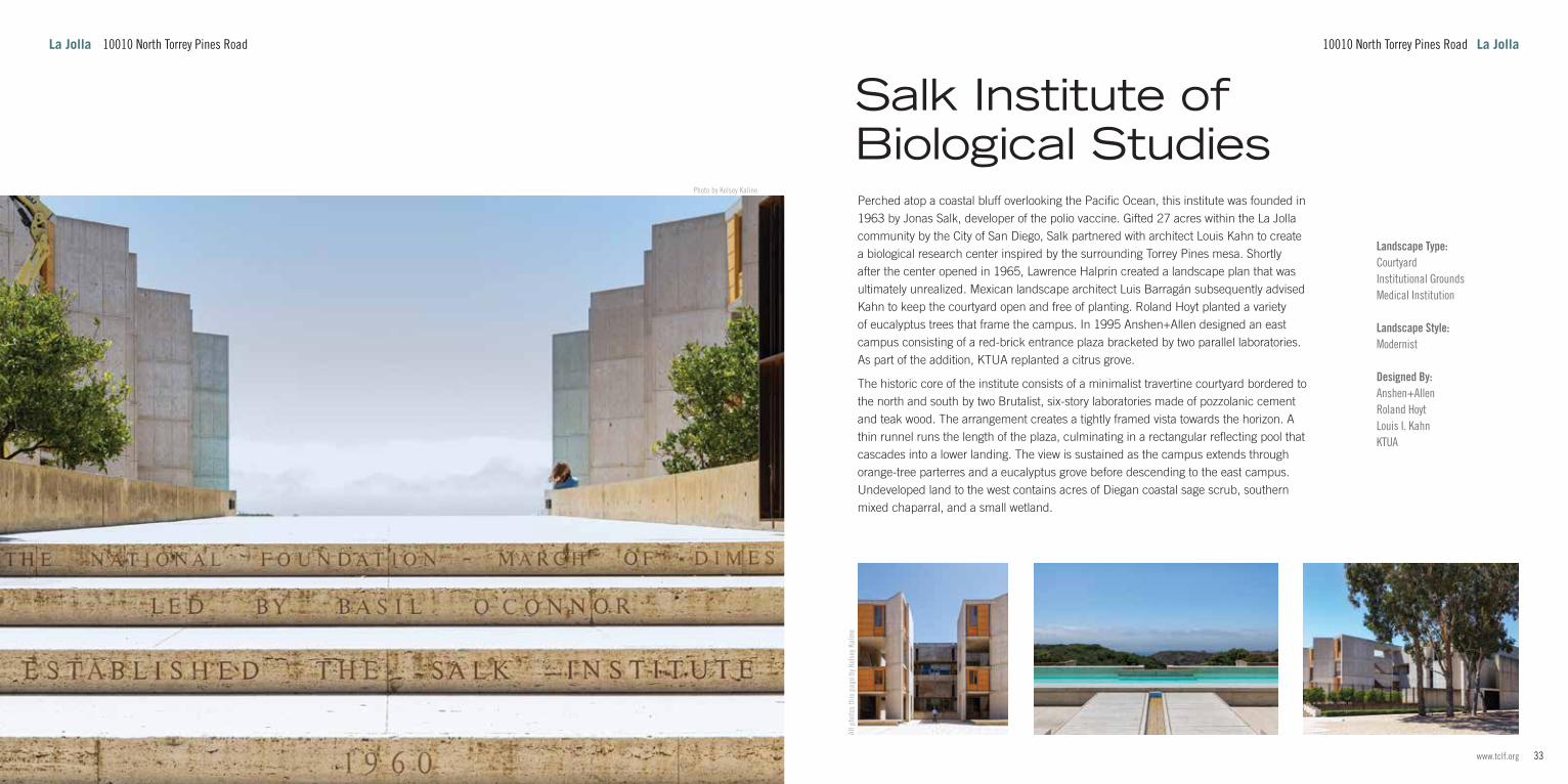
Perched atop a coastal bluff overlooking the Pacific Ocean, this institute was founded in 1963 by Jonas Salk, developer of the polio vaccine. Gifted 27 acres within the La Jolla community by the City of San Diego, Salk partnered with architect Louis Kahn to create a biological research center inspired by the surrounding Torrey Pines mesa. Shortly after the center opened in 1965, Lawrence Halprin created a landscape plan that was ultimately unrealized. Mexican landscape architect Luis Barragán subsequently advised Kahn to keep the courtyard open and free of planting. Roland Hoyt planted a variety of eucalyptus trees that frame the campus. In 1995 Anshen+Allen designed an east campus consisting of a red-brick entrance plaza bracketed by two parallel laboratories. As part of the addition, KTUA replanted a citrus grove.
The historic core of the institute consists of a minimalist travertine courtyard bordered to the north and south by two Brutalist, six-story laboratories made of pozzolanic cement and teak wood. The arrangement creates a tightly framed vista towards the horizon. A thin runnel runs the length of the plaza, culminating in a rectangular reflecting pool that cascades into a lower landing. The view is sustained as the campus extends through orange-tree parterres and a eucalyptus grove before descending to the east campus. Undeveloped land to the west contains acres of Diegan coastal sage scrub, southern mixed chaparral, and a small wetland.
All p
hoto
s th
is p
age
by K
else
y Kal
ine
Salk Institute of Biological Studies
10010 North Torrey Pines Road La JollaLa Jolla 10010 North Torrey Pines Road

35www.tclf.org34 The Cultural Landscape Foundation
Photo by Kelsey Kaline
Landscape Type:Campus
Landscape Style:Modernist
Designed By:KTUASkidmore, Owings & MerrillWimmer Yamada & AssociatesJoseph Y. Yamada
Related Landscapes:University of California, San Diego
Established by William Ritter as the Marine Biological Association of San Diego in the boathouse of the Hotel del Coronado in 1903, the organization relocated to La Jolla Cove Park in 1905 before finally settling on its current location, a 170-acre tract south of the Torrey Pines State Natural Reserve, in 1907. In 1912 the association was incorporated into the University of California and was renamed the Scripps Institution of Biological Research to honor its benefactors, Edward Willis Scripps and his sister Ellen. Originally consisting of a pier, laboratory, and director’s house, the Scripps Institution of Oceanography (as renamed in 1925) was expanded during the 1960s, with a new entrance designed by Wimmer Yamada & Associates.
To preserve ocean views from nearby homes, Joseph Yamada sunk an entrance parking lot below a lawn with gently rolling turf mounds, a signature element of his later designs. As the campus expanded northwards in the 1960s with further work by Yamada, grading became an increasingly critical part of the cliffside site. Gradually sloping terrain south of the pier gives way to a sharp incline towards a 200-foot-high bluff. Responding to the site conditions, buildings are situated at various angles and levels. KTUA has undertaken efforts to further stabilize the slopes. A suspension bridge spans La Jolla Shore Drive to connect the east campus, developed by Skidmore, Owings & Merrill in the 1980s. As with the lower campus, the buildings are accompanied by rolling lawns and embellished with succulent gardens.
All photos this page by Kelsey Kaline
Scripps Institution of Oceanography
8622 Kennel Way La JollaLa Jolla 8622 Kennel Way
37www.tclf.org36 The Cultural Landscape Foundation
Photo by Geoff Dude
Landscape Type:Public ParkNeighborhood Park
Designed By:Wallace Roberts & Todd
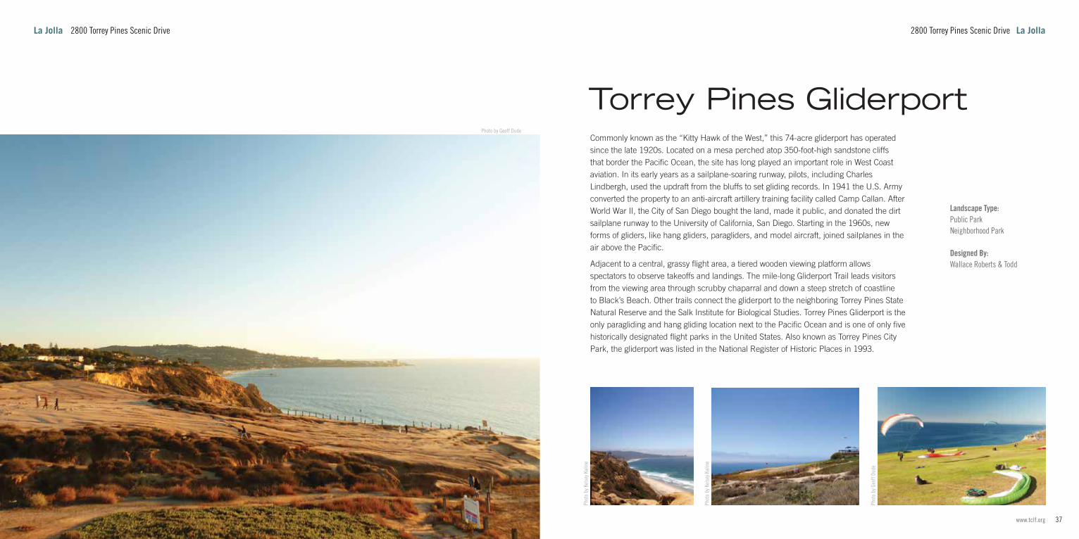
Commonly known as the “Kitty Hawk of the West,” this 74-acre gliderport has operated since the late 1920s. Located on a mesa perched atop 350-foot-high sandstone cliffs that border the Pacific Ocean, the site has long played an important role in West Coast aviation. In its early years as a sailplane-soaring runway, pilots, including Charles Lindbergh, used the updraft from the bluffs to set gliding records. In 1941 the U.S. Army converted the property to an anti-aircraft artillery training facility called Camp Callan. After World War II, the City of San Diego bought the land, made it public, and donated the dirt sailplane runway to the University of California, San Diego. Starting in the 1960s, new forms of gliders, like hang gliders, paragliders, and model aircraft, joined sailplanes in the air above the Pacific.
Adjacent to a central, grassy flight area, a tiered wooden viewing platform allows spectators to observe takeoffs and landings. The mile-long Gliderport Trail leads visitors from the viewing area through scrubby chaparral and down a steep stretch of coastline to Black’s Beach. Other trails connect the gliderport to the neighboring Torrey Pines State Natural Reserve and the Salk Institute for Biological Studies. Torrey Pines Gliderport is the only paragliding and hang gliding location next to the Pacific Ocean and is one of only five historically designated flight parks in the United States. Also known as Torrey Pines City Park, the gliderport was listed in the National Register of Historic Places in 1993.
Phot
o by
Kel
sey K
alin
e
Phot
o by
Kel
sey K
alin
e
Phot
o by
Geo
ff Du
de
Torrey Pines Gliderport
2800 Torrey Pines Scenic Drive La JollaLa Jolla 2800 Torrey Pines Scenic Drive

39www.tclf.org38 The Cultural Landscape Foundation
Photo by Kelsey Kaline
Landscape Type:Public ParkScenic ReservationState Park
Landscape Style:Naturalistic or Cohesive
Designed By:Ralph Dalton CornellGuy Fleming Herbert Jackson Richard Requa
This reserve was established on 364 acres of former pueblo land in 1899 by the San Diego City Council. Shortly after naturalist Guy Fleming laid out the reserve’s first trail system in 1921, landscape architect Ralph Cornell created a restrained master plan that preserved the park’s natural landscape. A second ordinance in 1924 expanded Torrey Pines Park to nearly 1,000 acres, encompassing cliffs, canyons, and mesas. In the late 1920s, architects Richard Requa and Herbert Jackson designed the Pueblo Revival-style Torrey Pines Lodge, which has since become the visitor center. The Guy and Margaret Fleming House, built by Guy Fleming in 1927, was listed in the National Register of Historic Places in 1998 and now serves as the Torrey Pines Reserve Ranger Residence. In 1936 the present North and Parry Groves were bequeathed to the city by philanthropist Ellen Browning Scripps. The site became a state park in 1959, granting the reserve added protections. An additional 197 acres were added to the park in 1970, and, in 2007, the name was changed to Torrey Pines State Natural Reserve. Located some 21 miles north of San Diego, the site covers 1,750 acres of seaside woodland, coastal shrubland, and salt marshes, alongside miles of sand beaches and scenic trails. The park preserves the torrey pine, considered one of the rarest pine trees in the world, and which is endemic to the La Jolla region.
All photos this page by Kelsey Kaline
Torrey Pines State Natural Reserve
12600 North Torrey Pines Road La JollaLa Jolla 12600 North Torrey Pines Road

41www.tclf.org40 The Cultural Landscape Foundation
Photo by Kelsey Kaline
La Jolla 9500 Gilman Drive
Landscape Type:CampusMultiversity Campus
Landscape Style:Modernist
Designed By:Robert E. Alexander & Associates Archibald Quincy Jones Robert Mosher OJB Landscape Architecture William Pereira PWP Landscape ArchitectureSchmidt Design GroupSkidmore, Owings & Merrill Spurlock Landscape Architects Emmet L. Wemple & Associates William L. Pereira & Associates Wimmer Yamada & Associates
Founded as part of the University of California system in 1956, the campus is composed of three sections (the West Campus, East Campus, and the Scripps Institution of Oceanography) that together total some 2,141 acres, with almost half kept as natural reserves. Built atop a mesa, the West Campus is the product of a 1963 master plan by architect Robert Alexander. Alexander initially created a cluster college plan with three groupings of four colleges, although only six were built. Architect Robert Mosher adjusted plans for the Second College (Revelle) with deference to the human scale, laying the groundwork for architect A. Quincy Jones’ revision of Alexander’s master plan in 1966. Engaged from 1960 to 1976, landscape architects Wimmer Yamada & Associates created a plan with undulating lawns and lava rock walls, while retaining existing eucalyptus and torrey pine trees. In 1989 Skidmore, Owings & Merrill, along with landscape architect Emmet Wemple, devised a new master plan. Within the West Campus, six academic colleges and the School of Medicine orbit the Brutalist Geisel Library. Separated by the San Diego Freeway, the East Campus contains the institution’s graduate and professional housing, while the 170-acre Scripps Institution lies along coastal bluffs. The colleges and their associated residential “neighborhoods” are architecturally distinct and contained within quadrangle plans, each enclosing pedestrian malls, plazas, and courtyards. The Stewart Collection, a series of on-site public artworks, is dispersed throughout the campus. A 112-acre eucalyptus grove links the Scripps Institution with the East Campus.
All p
hoto
s th
is p
age
by K
else
y Kal
ine
9500 Gilman Drive La Jolla
University of California, San Diego

43www.tclf.org42 The Cultural Landscape Foundation
Landscape Type:ZooContemporary ZooInstitutional GroundsCultural Institution
Designed By:Takendo AriiJeff Katz ArchitectureKTUASchmidt Design GroupTadashi KuboPGAVWimmer Yamada & AssociatesHarriett Barnhart WimmerJoseph Y. Yamada
SeaWorld San Diego was the first in a series of marine zoological parks founded by businessmen David Demott, George Millay, Ken Norris, and Milton Shedd. Wimmer Yamada & Associates laid out the landscape, creating a park-like environment characterized by mounded lawns, mature trees, and botanical collections. A traditional Japanese village with a garden designed by landscape architect Tadashi Kubo was a prominent feature. Plantings for the village garden were approved by landscape architect Garrett Eckbo, who had previously created design guidelines for the entirety of Mission Bay. The park opened in 1964 on 22 acres of filled marshland leased by the City of San Diego. As it grew over subsequent decades, reaching 110 acres by 1985, the landscape created by Wimmer Yamada & Associates was considerably altered.
Situated on a peninsula between Mission Valley and Mission Bay, this 189-acre site is a mix of an amusement theme park and an oceanarium. The development contains various animal exhibits, rides, stadium arenas, and amphitheaters. Sloping down towards the waterfront, the park also features a network of curvilinear paths bordered by Mediterranean garden beds, as well as Japanese, Polynesian, and Pacific Northwest regional plantings. The park is planted with some 4,000 different plant species, with several of the largest trees surviving from the Wimmer Yamada era. The original landscape design is more evident along the park’s northern border, where gently rolling lawns and curvilinear promenades, shaded by groupings of torrey pines and palms, meet the shoreline.
Photo by Jeremy Thom
pson
Photo courtesy WYI Al
l pho
tos
this
pag
e by
Kel
sey K
alin
e
Landscape Type:Suburb
Designed By:William Sterling HebbardMorris B. Irvin William Templeton JohnsonLloyd RuoccoKate Olivia Sessions
This residential district overlooks Old Town and the San Diego Bay, just north of the city’s downtown. The formerly hilly chaparral was initially purchased by S.T. Johnston of the Pacific Coast Steamship Company in 1869. He subsequently deeded 65 acres to his daughter, Sarah Cox Miller, who named the area Johnston Heights. In 1908 the real estate company Gordon, Goodwin & Co., along with George Marston, purchased the land for residential development. Connected to downtown San Diego via electric streetcar in 1910 by John Spreckels, Mission Hills quickly attracted wealthy residents who filled the neighborhood with homes designed by some of city’s most noted architects and master builders, such as William Hebbard, William Johnson, and Morris Irvin. Horticulturist Kate Sessions purchased land in the area, opening the Mission Hills Nursery in 1910. In the 1950s, homes by Modernist architects such as Lloyd Ruocco were constructed along the canyon’s rims.
Although extensive regrading occurred within nearby neighborhoods, the district’s streets follow the natural terrain of the canyons. The district comprises two adjacent residential pockets, together containing 174 homes that represent one of the city’s most intact concentrations of early-twentieth-century styles, from Craftsman and Prairie to Spanish Colonial Revival. The narrow side streets are lined with mature shade trees, while the wider Sunset Boulevard is bordered by palm trees. A separate historic district, the Fort Stockton Line District, comprising the area around the former streetcar line, is located to the north.
Photo courtesy Wikim
edia Comm
ons
Mission Hills Historic DistrictSeaWorld San Diego
Mission HillsMission Bay 500 Sea World Drive

45www.tclf.org44 The Cultural Landscape Foundation
Photo by Kelsey Kaline
4002 Wallace Street Mission Hills
Landscape Type:Restoration VillageHistoric Site
Landscape Style:Spanish Colonial Revival (Hispano-Moorish)
Designed By:Hazel Wood Waterman
This early Spanish settlement was established following the abandonment of the El Presidio Reál, a military garrison built atop Presidio Hill in 1769. Following a century of slow growth due to its distance from San Diego Bay, the old town was replaced as the center of San Diego by the development of Horton’s Addition in 1867. As suburbs enveloped the region in the twentieth century, renewed public interest in the early town led to its restoration and reconstruction. In 1968 Old Town San Diego was designated a state historic park.
Located four miles northwest of downtown San Diego, the seventeen-acre site is accessed by pedestrian-only streets oriented around the Plaza de Las Armas. Also called Washington Square, the plaza is a one-acre, rectangular lawn shaded by eucalyptus trees. Reflecting different stages of Mexican and American occupation, the streets are lined by 22 historic and reconstructed adobe, brick, and wood-frame structures. Southeast of the plaza is the prominent Casa de Estudillo, the setting of Helen Hunt Jackson’s nineteenth-century romance novel Ramona. Sugar magnate John Spreckels commissioned local architect Hazel Waterman to restore the building and design the formal courtyard gardens. At the southern end of the plaza, a ship mast, serving as a flagpole, commemorates the first American flag raised here in 1848. The Casa de Estudillo was listed in the National Register of Historic Places in 1970, soon followed by the Old Town San Diego State Historic Park, listed as an historic district in 1971.
Mission Hills 4002 Wallace Street
All photos this page by Kelsey Kaline
Old Town San Diego State Historic Park
47www.tclf.org46 The Cultural Landscape Foundation
Photo by Kelsey Kaline
Mission Hills 2811 Jackson Street
Landscape Type:Public ParkNeighborhood Park
Landscape Style:Picturesque
Designed By:Percy BroellRoland Hoyt William Templeton Johnson John NolenKate Olivia Sessions
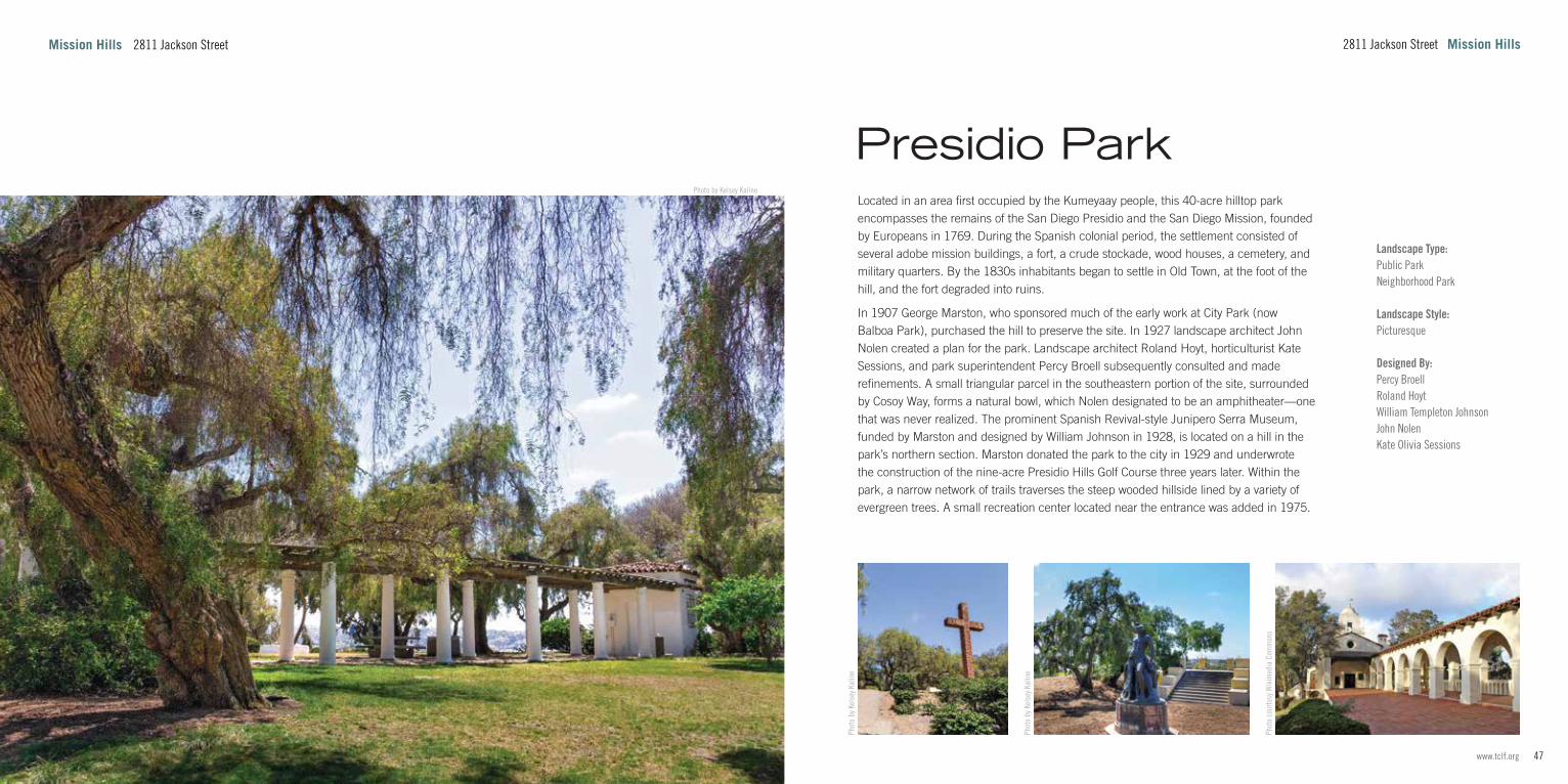
Located in an area first occupied by the Kumeyaay people, this 40-acre hilltop park encompasses the remains of the San Diego Presidio and the San Diego Mission, founded by Europeans in 1769. During the Spanish colonial period, the settlement consisted of several adobe mission buildings, a fort, a crude stockade, wood houses, a cemetery, and military quarters. By the 1830s inhabitants began to settle in Old Town, at the foot of the hill, and the fort degraded into ruins.
In 1907 George Marston, who sponsored much of the early work at City Park (now Balboa Park), purchased the hill to preserve the site. In 1927 landscape architect John Nolen created a plan for the park. Landscape architect Roland Hoyt, horticulturist Kate Sessions, and park superintendent Percy Broell subsequently consulted and made refinements. A small triangular parcel in the southeastern portion of the site, surrounded by Cosoy Way, forms a natural bowl, which Nolen designated to be an amphitheater—one that was never realized. The prominent Spanish Revival-style Junipero Serra Museum, funded by Marston and designed by William Johnson in 1928, is located on a hill in the park’s northern section. Marston donated the park to the city in 1929 and underwrote the construction of the nine-acre Presidio Hills Golf Course three years later. Within the park, a narrow network of trails traverses the steep wooded hillside lined by a variety of evergreen trees. A small recreation center located near the entrance was added in 1975.
Phot
o by
Kel
sey K
alin
e
Phot
o by
Kel
sey K
alin
e
Phot
o co
urte
sy W
ikim
edia
Com
mon
s
2811 Jackson Street Mission Hills
Presidio Park

49www.tclf.org48 The Cultural Landscape Foundation
Landscape Type:Golf CourseGolden Age
Landscape Style:Picturesque
Designed By:William Park Bell
Situated at the foot of Presidio Hill, this nine-acre golf course contains Casa de Carrillo, the oldest surviving adobe home in San Diego. Constructed circa 1817, the home is now used as a clubhouse. The property was acquired by George Marston and other members of the San Diego Chamber of Commerce circa 1907. Marston underwrote the restoration of the property and the development of the surrounding golf course. Opened in 1932, the eighteen-hole course is one of the oldest par-three golf courses in the country. Golf course architect William Bell designed the links for a challenging short game, utilizing hollows and hills and limiting holes to no more than 94 yards. In the late twentieth century, ownership of the park was transferred to the City of San Diego, which has since leased it to various caretakers. Referred to as the ‘cradle of golf in San Diego,’ the course has hosted many Junior World Championships, awarding titles to such famed professionals as Tiger Woods, Lorena Ochoa, and Phil Mickelson.
Built on a gentle incline, the course slopes upwards towards Presidio Hill. Several large shade trees, including oak, linden, and sweetgum, dot the main links, while a tree line and hedgerows, surrounded by varieties of native cacti and succulents, screen the course to the east and south. From 2015 to 2017, the historic pepper trees framing the course to the southeast were removed. A dirt baseball diamond is located at the site’s northwest corner.
All p
hoto
s th
is p
age
by K
else
y Kal
ine
Landscape Style:Mission Revival
Designed By:John DavidsonWilliam Sterling Hebbard Irving GillJane MinshallKate Olivia Sessions
Situated a mile north of Balboa Park, this neighborhood was initially planned to include the San Diego College of Arts, which became the State Normal School (designed by architects Irving Gill and William Hebbard with a landscape design by Jane Minshall). The community also featured a lake and an area known as the Bluffs, a five-acre park bookending the northern terminus of a trolley line. In 1898 John Spreckels purchased the trolley line and park (renamed Mission Cliff Gardens) and expanded the grounds to nearly twenty acres, hiring landscape gardener John Davidson to redevelop the site into a botanical garden. While the neighborhood grew following the extension of the trolley line in 1907, the popularity of the Panama-California Exposition and the advent of automotive travel contributed to the decline of Mission Cliff Gardens, which closed in 1930.
Today, the mixed-use University Heights neighborhood encompasses more than one square mile and is perched atop steep densely vegetated cliffs. The Trolley Barn Park (built on the site of a trolley barn razed in 1979) features a grid of palm trees and a playground bordered by paths that reference the local street layout. Throughout the community, elements of the Mission Cliff Gardens landscape survive, including a filled-in lily pond and a wall inlaid with cobblestones. The southern edge of the neighborhood is anchored by the only remaining structure from the 1897 Normal School campus. Known today as the Teacher’s Training Annex #1, the Italian Renaissance Revival-style structure was built in 1910 and was listed in the National Register of Historic Places in 1993.
All photos this page by Kelsey Kaline
University HeightsPresidio Hills Golf Course
University Heights Mission HillsMission Hills 4136 Wallace Street

51www.tclf.org50 The Cultural Landscape Foundation
Photo by Kelsey Kaline
3000 Guajome Lake Road, Oceanside North of San Diego
Landscape Type:Public ParkScenic Reservation
Designed By:Jerry Buteyn
Originally home to the Luiseño tribe of Mission Indians, the area became part of the Mission San Luis Rey de Francía in 1798 before being consolidated into an 1845 land grant by the Mexican government. Shortly afterwards, the property was gifted to Ysidora Bandini, wife of Lt. Cave Johnson Couts, and became the base of the family’s ranching operation. Their adobe house, a National Historic Landmark, is located 1.5 miles southeast of the park. In the 1940s the land was sold to Jerry Buteyn, who created the popular Buteyn Bird Farm, a zoo-like attraction. Buteyn established extensive terracing in the park, planted palm and olive trees, and constructed both a lake and a marsh. The County of San Diego purchased the land to establish a public park in 1973.
Located seven miles east of Oceanside in north San Diego County, the 394-acre regional park includes nearly five miles of trails that loop through woodland, chaparral, grassland, and riparian wetland habitats. An interpretive nature trail circles the 25-acre lake before crossing the marsh through a corridor of willow, palm, and eucalyptus trees. Park amenities include a campground, a rustic cabin, a playground, picnic areas, and an amphitheater. The southern section of the park is primarily a marshy grassland populated with coastal sagebrush and Mexican fan palms. Relics of the irrigation system that created the marsh in the 1940s can still be seen. The park attracts more than 186 species of migratory birds, with a small pond in the eastern section serving as an important stopover.
North of San Diego 3000 Guajome Lake Road, Oceanside
All photos this page by Kelsey Kaline
Guajome Regional Park

53www.tclf.org52 The Cultural Landscape Foundation
Photo by Kelsey Kaline
North of San Diego 6200 Flying Leo Carrillo Lane, Carlsbad
Landscape Type:Public ParkNeighborhood Park
Landscape Style:Spanish Colonial Revival (Hispano-Moorish)
Designed By:Coastal Sage Landscape ArchitectureLeo CarrilloKTUA
Initially named Rancho De Los Kiotes after the native Yucca slopes, the ranch was built as a retreat for actor Leo Carrillo, who purchased the original 1,700 acres in 1937, adding 838 acres two years later. Located on an old Spanish land grant, the 2,358 acres and surrounding area were once home to the Luiseño people. The main living quarters, two wooden windmills, a chicken house, a storage shed, a barn, and a cattle chute are arranged in an organic layout amid sporadic olive, willow, and agave plantings and sparse lawns. Carrillo intended the ranch to pay homage to the Spanish California landscape and his Mexican American heritage. The main U-shaped hacienda is built around a flagstone courtyard, which opens onto a garden housing a fishpond, swimming pool, cabana, a totem pole, and a small pueblo-style dwelling. Situated in a chaparral-filled canyon, the ranch features palm, pepper, citrus, and eucalyptus trees, and varieties of cacti and succulents. The western section of the site comprises arid, wooded wilderness. In 1960 some 1,000 acres were sold to developers for a residential subdivision. The sale of the remaining 10.5 acres, including the ranch’s historic structures, in 1976 to the City of Carlsbad resulted in the creation of the park. Later, a transfer of 16.4 acres from contiguous residential subdivisions expanded the site to its current 27 acres. In the 1990s KTUA created a master plan, and in 2019 Coastal Sage Landscape Architecture implemented new pathways and historically sensitive treatments. The property was added to the National Register of Historic Places in 1992.
All p
hoto
s th
is p
age
by K
else
y Kal
ine
6200 Flying Leo Carrillo Lane, Carlsbad North of San Diego
Leo Carrillo Ranch Historic Park

55www.tclf.org54 The Cultural Landscape Foundation
Landscape Type:Institutional GroundsReligious Institution
Founded in 1798, this Spanish mission encompassed some 950,000 acres at the height of its development. The Mexican government secularized the mission in 1834, its lands then sold or gifted in land grants. Beginning in 1850, the mission became a U.S. Army base but was returned to the Catholic Church in 1865. Abandoned for nearly 30 years, the mission reopened in 1892. Over the next twenty years, the church was restored, and new living quarters were built on the original site of the mission. The quadrangle was rebuilt in 1949, and the soldiers’ barracks and lavanderia (open-air laundry) were unearthed throughout the 1950s and 1960s.
Situated on a hill south of the San Luis Rey River, the 56-acre site is centered around a quadrangle of dormitories and workshops that frame two courtyards containing a nearly 200-year-old pepper tree, various statues, colorful flower arrangements, and an enclosed monastic garden. Originally built in 1815, the adjacent cruciform church borders a cemetery founded in 1798. Partially shaded by deciduous trees, the north lawn contains the archaeological ruins of military barracks and a two-tiered stone fountain. Farther south, a brick archway opens onto a grand staircase that descends to the mission’s sunken garden, a tiled courtyard that once served as the lavanderia. In 1970 the Mission San Luis Rey de Francía was listed in the National Register of Historic Places and became a National Historic Landmark.
All p
hoto
s th
is p
age
by K
else
y Kal
ine
Landscape Type:Public Park
Landscape Style:Mission Revival
Established by a Mexican land grant in 1845, the Guajome Rancho initially comprised 2,219 acres consolidated from the Mission San Luis Rey de Francía. Following a series of purchases after the Mexican-American War, the property was given to Ysidora Bandini, wife of Lt. Cave Johnson Couts, as a wedding gift. Transformed into a cattle ranch that covered more than 31 square miles, the property, including the ranch house, barns, stables, sheds, servants’ quarters, corrals, and chapel, was developed and operated by indentured Luiseño Mission Indians. The property remained in the Couts family for 90 years, into the 1940s. The San Diego County Department of Parks and Recreation acquired 165 acres of the original land grant in 1973.
Situated 1.5 miles southeast of Lake Guajome, the restored adobe ranch house is surrounded by an arcaded veranda that looks onto natural wetlands. Built in 1853, the hacienda encloses an inner courtyard with a central fountain and a formal arrangement of orange trees, shrubs, flowers, and vines, the whole ensemble divided into four parts by flagstone pathways. Now an open area with a single century-old pepper tree, the outer carriage courtyard was once enclosed by a jail, blacksmith shop, horse stalls, carriage house, and reservoir. Southeast of the hacienda is a small chapel with contiguous manicured lawns planted with shade trees. The ranch was listed in the National Register of Historic Places and became a National Historic Landmark in 1970.
All photos this page by Kelsey Kaline
Rancho Guajome Adobe County Park
Mission San Luis Rey de Francía
2210 North Santa Fe Avenue, Vista North of San DiegoNorth of San Diego 4050 Mission Avenue, Oceanside
57www.tclf.org56 The Cultural Landscape Foundation
Photo by Kelsey Kaline
Landscape Type:Botanical Garden
Designed By:Deneen Powell AtelierMildred L. Macpherson Paul Mahalik Pius John “P.J.” Miller Gil Voss
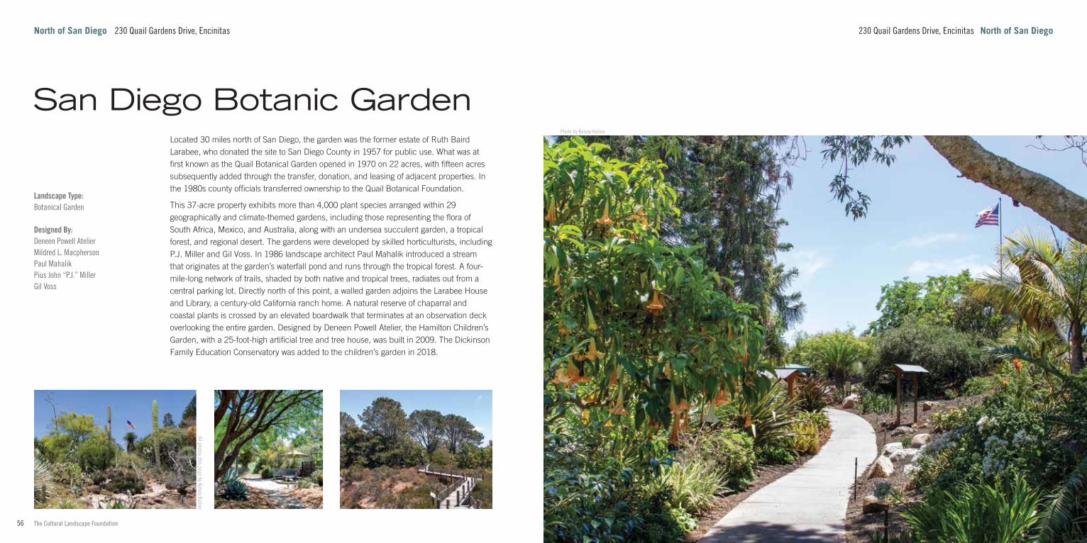
Located 30 miles north of San Diego, the garden was the former estate of Ruth Baird Larabee, who donated the site to San Diego County in 1957 for public use. What was at first known as the Quail Botanical Garden opened in 1970 on 22 acres, with fifteen acres subsequently added through the transfer, donation, and leasing of adjacent properties. In the 1980s county officials transferred ownership to the Quail Botanical Foundation.
This 37-acre property exhibits more than 4,000 plant species arranged within 29 geographically and climate-themed gardens, including those representing the flora of South Africa, Mexico, and Australia, along with an undersea succulent garden, a tropical forest, and regional desert. The gardens were developed by skilled horticulturists, including P.J. Miller and Gil Voss. In 1986 landscape architect Paul Mahalik introduced a stream that originates at the garden’s waterfall pond and runs through the tropical forest. A four-mile-long network of trails, shaded by both native and tropical trees, radiates out from a central parking lot. Directly north of this point, a walled garden adjoins the Larabee House and Library, a century-old California ranch home. A natural reserve of chaparral and coastal plants is crossed by an elevated boardwalk that terminates at an observation deck overlooking the entire garden. Designed by Deneen Powell Atelier, the Hamilton Children’s Garden, with a 25-foot-high artificial tree and tree house, was built in 2009. The Dickinson Family Education Conservatory was added to the children’s garden in 2018.
All photos this page by Kelsey Kaline
230 Quail Gardens Drive, Encinitas North of San DiegoNorth of San Diego 230 Quail Gardens Drive, Encinitas
San Diego Botanic Garden
59www.tclf.org58 The Cultural Landscape Foundation
Photo by Kelsey Kaline
Point Loma 1700 Cabrillo Memorial Drive
Landscape Type:CemeteryNational CemeteryCommemorative Landscape
Landscape Style:PicturesqueSpanish Colonial Revival (Hispano-Moorish)
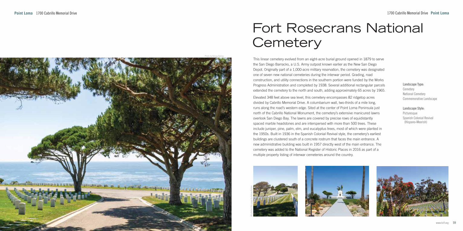
This linear cemetery evolved from an eight-acre burial ground opened in 1879 to serve the San Diego Barracks, a U.S. Army outpost known earlier as the New San Diego Depot. Originally part of a 1,000-acre military reservation, the cemetery was designated one of seven new national cemeteries during the interwar period. Grading, road construction, and utility connections in the southern portion were funded by the Works Progress Administration and completed by 1938. Several additional rectangular parcels extended the cemetery to the north and south, adding approximately 65 acres by 1965.
Elevated 348 feet above sea level, this cemetery encompasses 82 ridgetop acres divided by Cabrillo Memorial Drive. A columbarium wall, two-thirds of a mile long, runs along the road’s western edge. Sited at the center of Point Loma Peninsula just north of the Cabrillo National Monument, the cemetery’s extensive manicured lawns overlook San Diego Bay. The lawns are covered by precise rows of equidistantly spaced marble headstones and are interspersed with more than 500 trees. These include juniper, pine, palm, elm, and eucalyptus trees, most of which were planted in the 1950s. Built in 1936 in the Spanish Colonial Revival style, the cemetery’s earliest buildings are clustered south of a concrete rostrum that faces the main entrance. A new administrative building was built in 1957 directly west of the main entrance. The cemetery was added to the National Register of Historic Places in 2016 as part of a multiple property listing of interwar cemeteries around the country.
All p
hoto
s th
is p
age
by K
else
y Kal
ine
1700 Cabrillo Memorial Drive Point Loma
Fort Rosecrans National Cemetery

61www.tclf.org60 The Cultural Landscape Foundation
Photo by Kelsey Kaline
2850 Womble Road Point Loma
Landscape Type:Institutional GroundsMilitary Institution
Landscape Style:Beaux-Arts / Neoclassical
Designed By:KTUAJohn MorleyONA AssociatesLincoln Rogers
This 361-acre mixed-use neighborhood is located within the Point Loma community on the site of the former Naval Training Center San Diego. Constructed between 1921 and 1923, the initial 200-acre naval base served as a training center and was expanded to 550 acres before its decommission in 1999. It was subsequently sold to the City of San Diego, which converted the site to a mixed-use recreational and residential development.
The core of the landscape is laid out in a cruciform pattern established by architect Lincoln Rogers in the Beaux-Arts style. Along the perimeter of the axes, Spanish Colonial Revival structures are separated from each other by a series of symmetrical courtyards bookended by a tall spruce tree and a circular fountain. Surrounded by parallel walkways and edged with rows of trees, hedges, and flowering shrubs, the central mall was laid out by San Diego parks superintendent John Morley. Beginning in 1939, harbor improvements added 130 acres of filled land along the center’s east boundary, now partially occupied by the 45-acre NTC Park and Liberty Station esplanade, opened in 1993. Linear greens extend the north-south axis past the historic core through newer mixed-residential development, including a high school campus and military and civilian housing. Situated at the northwest corner of the site is the 15.5-acre, nine-hole Loma Club Golf Course. Dating to the 1910s, the course has since been redesigned. Redevelopment work has included a master plan by KTUA and designs for waterfront parks and courtyards by ONA. In 2000 the historic core of Liberty Station was listed in the National Register of Historic Places as the Naval Training Center Historic District.
Point Loma 2850 Womble Road
All photos this page by Kelsey Kaline
Liberty Station

63www.tclf.org62 The Cultural Landscape Foundation
What’s Out There® is the most comprehensive searchable database of North America's historic designed landscapes, with thousands of sites and images, and is optimized for iPhones and similar handheld devices. It includes What’s Nearby, a GPS-enabled function that locates all landscapes within a certain distance, customizable by mileage or walking time.
tclf.org/places Learn more about the sites in this guide and What’s Out There.
tclf.org/publications Get more guidebooks in the What's Out There series.
Lead Sponsors
tclf.org/san-diego for more about What's Out There San Diego
FriendsAHBE | MIG • Schmidt Design Group
Spurlock Landscape Architects
USA SHADE & Fabric Structures
Presenting Sponsors
Designed by Oviatt Media, this guidebook is the result of the scholarly support and photography provided by Charles A. Birnbaum, Scott Craver, Eduard Krakhmalnikov, Justin Clevenger and Ayla Mangold, with the guidance of local experts Sharon Singleton, Amy Hoffman, and Joy Lyndes.
All photos by The Cultural Landscape Foundation, unless otherwise noted. (left) Photo by Kelsey Kaline; (cover) Photo by Charles A. Birnbaum
Supporting Sponsors
BrightView Landscape Development
GroundLevel Landscape Architecture
OJB Landscape Architecture
Rios Clementi Hale Studios