what’s next for arcgis and you
TRANSCRIPT

Adam Carnow, Daniel Wickens, Sarah Scher
Esri Mid-Atlantic User Conference:
What’s Next for ArcGIS and You

YOUR WORKAddressing All Our World’s Challenges
Water Resources
Pollution
Environment
Climate
Change
Social Conflicts
Transparent
Government
Infrastructure
Urbanization
& Development
National
Security
Agriculture Science &
Technology

Regional Examples
Delaware Valley Regional Planning Commission – Connections 2045
New York MTA – Asset Management
Onandaga Co., NY Water Authority – Drone Water Tank Inspections
Philadelphia, PA – Affordable Housing

Regional Examples
Bucks Co., PA – Data Hub
Washington, DC – 3D Digital Twin & AR
Oak Hill, WV – City Council Agenda Story Map
Sussex Co., DE – Broadband Access Initiative

What’s Next and The
Science of Where

Embrace the Change, Be Proactive, Innovate,
Make a Difference, Increase Your Value to the Organization
Keep Moving, Learning, and Understanding . . .
Envision
What’s Possible
Modernize
Operations
Provide
Self-Service
Analytics
Make Organizations
Smarter
Monitor Systems
in Real-Time
More Effectively
Engage
Communities
Improve
Productivity
and Efficiency
Model the Real World
More AccuratelyWhat’s Next?
For IT trends, GIS, Esri, ArcGIS and YOU


GIS
Mapping
& Location
Intelligence
The Science of Where Is the FoundationFor Applying Geography Widely

Leveraging the Power of Geography . . .
to Make Better Decisions
A Framework
and Process
Action
Decision-
Making
Analysis &
Modeling
Planning &
Design
Visualization &
Mapping
Data Management
& Integration
Geographic
Knowledge

Leveraging the Power of Geography . . .
to Make Better Decisions
A Framework
and Process
Action
Decision-
Making
Analysis &
Modeling
Planning &
Design
Visualization &
Mapping
Data Management
& Integration
Geographic
Knowledge
VALUE

Leveraging the Power of Geography . . .
to Make Better Decisions
A Framework
and Process
Action
Decision-
Making
Analysis &
Modeling
Planning &
Design
Visualization &
Mapping
Data Management
& Integration
Geographic
Knowledge
VALUE
GIS
LOCATION
INTELLIGENCE
PLATFORM

Teams
Distributed
Leveraging
Web Services
Engaging
Everyone
Individuals
Departments
Organizations
Communities
Sharing and
Collaboration
. . . and
Interconnected
Web GIS Is the Modern GIS ArchitectureHelping Everyone Do Their Work Better

Digital Transformation
Digital Automation
Simultaneous
Sequential Workflows
Changing How Organizations as a Whole . . .
. . . Do Their Work
Integrated Operations
Web GIS Is Driving Digital TransformationHelping Organizations Reenvision Their Workflows

How Do We Take the Next Step?
. . . Create a Geoscience-Based Foundation for Our Future
Learn
Continuously
Understand
the Possibilities
Envision a
Better Future
Create Solutions
Inform &
Educate
Participate &
Take Action
Embrace
Technology
Take the Initiative
Work Together
Innovate
Embrace Digital Transformation . . .
. . . and Leverage The Science of Where

Pattern
• Four sections
- Modeling the Real World More Accurately
- Next Generation Planning
- Self-Service Analytics
- Operational Modernization
• Demonstrate how the ArcGIS platform contributes
• Review the technology shown and highlight applicable sessions

Modeling the Real
World More Accurately


Managing
Stormwater Assets

Recap
• Open Data Initiative site
• Web AppBuilder (WAB) powered Stormwater Report web app
• Collector for ArcGIS (Aurora)
• ArcGIS Pro 2.2
• Utility Network Management Extension
• ArcGIS Enterprise (Standard or Advanced)
• Operations Dashboard

Applicable Sessions
• Creating Dashboards with Configurable Apps
• ArcGIS Apps for the Field: An Overview

Next Generation
Planning

. . .Cumbersome, manual, paper-based. . .
The Traditional Planning Process

. . .To a digital process that engages the community. . .
The Planning Process Reimagined

Track and Evaluate Projects
Create Planning Scenarios
Report and Engage
Immersive and Collaborative
Digital Twin
Transforming the Process of Urban Development . . .
Plans
Zoning
Land Use
Transportation
Urban Performance
Suitability
Impact Evaluations
Indicators
Projects
Buildings
Infrastructure
• Government
• Architects
• Developers
• Citizens
Stakeholders
ArcGIS Urban | Will Revolutionize City Planning and Design

Next Generation
Planning

Recap
• ArcGIS Urban
• 3D Public Survey solution

Applicable Sessions
• Three Important Things to Know about 3D GIS

Self-Service Analytics

Dashboards
Making Your Analytics Widely Available . . .
. . . Taking GIS to the Edge
Apps Take The Science of Where . . . Everywhere
. . . Opening Spatial Analytics to Everyone
Insights
for
ArcGIS
Business Analyst

Self-Service
Analytics

Recap
• Insights for ArcGIS
• ArcGIS Pro
• Living Atlas
• Tapestry Segmentation Data
• ArcGIS Business Analyst Web App
• Infographic
• Story Map

Applicable Sessions
• Living Atlas of the World: An Introduction
• Applying Machine Learning to your Analysis in ArcGIS Pro

Operational
Modernization

. . .to Revolutionize the Way You Work…
Envision
What’s Possible
Monitor Systems
in Real-Time
More Effectively
Engage
Communities
Improve
Productivity
and Efficiency
Operational ModernizationUsing ArcGIS for Organizational Transformation
Provide GIS
Access to
Everyone
Support
More Informed
Decision Making
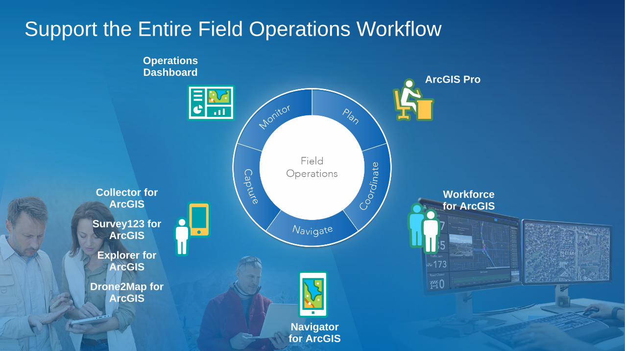
Support the Entire Field Operations Workflow
Operations Dashboard
Navigator for ArcGIS
ArcGIS Pro
Workforce for ArcGIS
Survey123 for ArcGIS
Collector for ArcGIS
Drone2Map for ArcGIS
Explorer for ArcGIS

Modernizing Public
Works Operations

Recap
• ArcGIS Hub
• Survey123
• Microsoft Flow
• Workforce for ArcGIS
• ArcGIS Online / ArcGIS Enterprise
• Navigator for ArcGIS
• Spike from IkeGPS
• Operations Dashboard
• Story Map
• Amazon Echo Dot

Applicable Sessions
• ArcGIS for Public Works: An Introduction
• Survey123: Advanced Topics
• Creating Dashboards with Configurable Apps

Additional Sessions of Interest
• Day Two Plenary
• GIS for Leaders: Seven Elements of a Successful Enterprise GIS
• ArcGIS Monitor: An Introduction
• Manage Your GIS People, Process and Technology with Best Practices
• How to Cultivate Executive Sponsorship for Your GIS Program

Leveraging the Power of Geography . . .
to Make Better Decisions
A Framework
and Process
Action
Decision-
Making
Analysis &
Modeling
Planning &
Design
Visualization &
Mapping
Data Management
& Integration
Geographic
Knowledge
VALUE
GIS
LOCATION
INTELLIGENCE
PLATFORM

Embrace the Change, Be Proactive, Innovate,
Make a Difference, Increase Your Value to the Organization
Keep Moving, Learning, and Understanding . . .
Envision
What’s Possible
Modernize
Operations
Provide
Self-Service
Analytics
Make Organizations
Smarter
Monitor Systems
in Real-Time
More Effectively
Engage
Communities
Improve
Productivity
and Efficiency
Model the Real World
More AccuratelyWhat’s Next?
For IT trends, GIS, Esri, ArcGIS and YOU

How Do We Take the Next Step?
. . . Create a Geoscience-Based Foundation for Our Future
Learn
Continuously
Understand
the Possibilities
Envision a
Better Future
Create Solutions
Inform &
Educate
Participate &
Take Action
Embrace
Technology
Take the Initiative
Work Together
Innovate
Embrace Digital Transformation . . .
. . . and Leverage The Science of Where

— Charles Darwin
“It is not the strongest of the species that survive,
Nor the most intelligent,
But the ones most responsive to change.”

THANK YOU!
