white paper of the dsd working group 3 -...
TRANSCRIPT

Monitoring and assessMent of desertification and
Land degradation:
KnowLedge ManageMent, institutions and econoMics
White Paper of the DSD Working Group 3
Edited by: Mariam Akhtar-Schuster, Harriet Bigas and Richard Thomas
UNU Desertification Series No. 9

Monitoring and Assessment of
Desertification and Land Degradation: Knowledge Management, Institutions and
Economics
White Paper of the DSD Working Group 3
Edited by: Mariam Akhtar-Schuster, Harriet Bigas and Richard Thomas
Association of DesertNet International United Nations University – Institute for Water, Environment and Health
Dryland Science for Development Consortium
February 2010

ii
This White Paper is a result of an international collaboration and consultation coordinated by Working Group 3 of the Dryland Science for Development Consortium. The findings of this Paper were presented at the First UNCCD Scientific Conference held during the COP-9 in Buenos Aires, Argentina from 22-24 September 2009. The final version of the White Paper takes into account the feedback and comments received during the online global consultation from May-August 2009 and those received at the Scientific Conference. Working Group 3 is co-chaired by the Association of DesertNet International and the United Nations Institute for Water, Environment and Health. For more information, please contact the DSD Working Group 3 leaders: Dr. Mariam Akhtar-Schuster ([email protected]) and Dr. Richard Thomas ([email protected]). Please see www.drylandscience.org for more information on the DSD and for the findings and White Papers of Working Groups 1 and 2.
This document is available at: www.european-desertnet.eu
www.inweh.unu.edu www.drylandscience.org
Coordinating authors and editors: Mariam Ahktar-Schuster, Harriet Bigas and Richard Thomas Lead authors: Mariam Akhtar-Schuster, Pamela Chasek, Mark Reed, Mélanie Requier-Desjardins, Stefan Sperlich, Lindsay Stringer and Richard Thomas Contributing authors and reviewers: Bhim Adhikari, Julius Atlhopheng, John Antle, Felicitas Bachmann, Gary Bastin, Gérard Begni, Marc Bied-Charreton, Harriet Bigas, Silke Brehm, Eleni Briassouli, Mourad Briki, John Briggs, Michaela Buenemann, Sally Bunning, Martin Bwalya, Raban Chanda, Valentin Ciubotaru, Jonathan Davies, Meike Dickel, Esther Diez, Secretariat of Diversitas International, Andy Dougill, Guiseppe Enne, Stefan Erasmi, Wafa Essahli, Ioan Fazey, Luuk Fleskens, Nicky Geeson, Alain Grainger, Stefano Grego, Ingrid Hartmann, Peter Herkenrath, Rudi Hessel, Joseph Holden, Klaus Hubacek, Antono Ioris, Doru Leonard Irimie, Jessica Jones, Nick Jordan, Nabil Ben Khatra, Mike Kirby, Bertus Kruger, Praveen Kujal, Alejandro Lago, Pietro Laureano, John Lehmann, Hans-Peter Liniger, Pedro Machado, Lago Magole, Dimitri Margaritis, Rainer Marggraf, Carlos San Juan Mesonada, Wanda Mphinyane, Doan Nainggolan, David Niemeijer, Ren Ohinata, David Ojima, G. Olukoye, Siv Oystese, Soledad Parada, Eric Patrick, Jem Perkins, Jeremy Phillipson, Christina Prell, Juan Puigdefabregas, Giovanni Quaranta, Claire Quinn, Christopher Raymond, Coen Ritsema, Alison Reeves, Per Ryden, Joachim Saborowski, Ute Schmiedel, Brigitte Schuster, Maurizio Sciortino, Reuben J. Sebego, Mary Seely, Lindsay Stringer, Houcine Taamallah, Gudrun Schwilch, Stephen Twomlow, Marie Jose van der Werff Ten Bosch, Petra Vergunst, Simone Verzandvoort, Lynn Wagner, Qian Ye, Chiara Zanolla and Walter Zucchini

iii
Acknowledgements We are grateful for the contributions made from the following delegates during the First UNCCD Scientific Conference at COP-9: Argentina, Brazil, Chile, China, France, Holy See, India, Jamaica, Mali, Morocco, Nicaragua, Niger, Nigeria, Peru, Saudi Arabia, Senegal, South Africa, Yemen, UNEP and UNFCCC. The tireless efforts of Harriet Bigas (UNU-INWEH) and Chiara Zanolla (NRD, Italy) are acknowledged for their indispensable coordinating support in preparation of the First UNCCD Scientific Conference and in the finalisation of the White Paper and Conference Proceedings. We thank Jan Moeller (Biocentre Klein Flottbek and Botanical Garden, University of Hamburg, Germany) for the logistic and technical support in preparation of the two Working Group 3 preparatory workshops at the University of Hamburg, Germany during the international consultation phase. We thank the Convention Project to Combat Desertification (CCD Project) of Deutsche Gesellschaft für Technische Zusammenarbeit (GTZ) GmbH acting on behalf of the German Federal Ministry for Economic Cooperation and Development (BMZ) for generous financial support in the consultations and preparation of this white paper.

iv
The United Nations University (UNU) is an organ of the United Nations established by the General Assembly in 1972 to be an international community of scholars engaged in research, advanced training and the dissemination of knowledge related to pressing global problems of human survival, development and welfare. The UNU Institute for Water, Environment and Health (UNU-INWEH) is a member of the UNU family which focuses on strengthening water management capacity, particularly of developing countries, and providing on-the-ground project support. The Association of DesertNet International (DNI) is a non-governmental, non-profit international scientific network composed of scientists working in bio-physical and human sciences research on land degradation and desertification. This international scientific network has no government affiliation and is independent of any form of lobby or private interests. DesertNet International encourages interdisciplinary research on desertification, land degradation, drought, and sustainable land management, and facilitates international scientific exchange of information and partnership building. DesertNet International identifies priority areas for research and provides academically sound data and information on dryland development issues to policy-makers. Disclaimer The designations employed and presentations of material throughout this publication do not imply the expression of any opinion whatsoever on the part of the United Nations University (UNU) concerning legal status of any country, territory, city or area or of its authorities, or concerning the delimitation of its frontiers or boundaries. The views expressed in this publication are those of the respective authors and do not necessarily reflect the views of UNU. Mention of the names of firms or commercial products does not imply endorsement by UNU. © The United Nations University, 2010. Available from: United Nations University – Institute for Water, Environment and Health (UNU-INWEH) 175 Longwood Road South, suite 204 Hamilton, Ontario L8P 0A1 CANADA Tel: +1 905 667 5511 Fax: +1 905 667 5510 Email: [email protected] Web: www.inweh.unu.edu Cover photo credits: Zafar Adeel, Ute Schmiedel and Richard Thomas. ISBN 92-808-6014-3

v
Table of Contents
WG 3 White Paper Summary and Recommendations ................................................. 1 1. Chapter 1: Introduction ....................................................................................... 7
1.1. The Need for Monitoring and Assessment ............................................................ 7 1.2. Challenges to the Implementation of Monitoring and Assessment Systems ......... 8 1.3. Consideration of the Complexity of Land Degradation .......................................... 9 1.4. The Need for Better Integration of Effort ............................................................. 11
2. Chapter 2: Knowledge Management and Institutions for Monitoring and Assessment of Desertification and Land Degradation .............................................. 14
2.1. Summary and Key Recommendations ................................................................ 14 2.2. Introduction .......................................................................................................... 15 2.3. Principles of Knowledge Management ................................................................ 16 2.4. Knowledge Management for Monitoring DLD ..................................................... 22
I. Horizontal local knowledge management ............................................................ 22 II. Horizontal national knowledge management ...................................................... 33 III. Horizontal international knowledge management (including regional) ................ 41 IV. Vertical knowledge management: linking land degradation monitoring and
assessment from local to international scales ..................................................... 51 2.5. Mainstreaming Monitoring and Assessment ....................................................... 60
I. Challenges to mainstreaming .............................................................................. 60 II. Sustainability of M&A .......................................................................................... 65 III. Conclusions ......................................................................................................... 66
3. Chapter 3: Economic and Policy Considerations .......................................... 67 3.1. Summary and Key Recommendations ................................................................ 67 3.2. Introduction .......................................................................................................... 68 3.3. The Economic Framework .................................................................................. 68
I. The Externalities of DLD ..................................................................................... 69 II. The Valuation of DLD .......................................................................................... 71
3.4. Costs for Monitoring ............................................................................................ 79 3.5. Suggestions for Policy Support for DLD and M&A .............................................. 79
I. Instruments for the Management of Externalities ................................................ 80 3.6. Valuation of actions to combat DLD and to promote international investments .. 86 3.7. Recommendations and Conclusions ................................................................... 89
References ..................................................................................................................... 91 Annex I. Scientific Bodies Needed to Support the UNCCD ..................................... 106
1. Key Recommendation(s) ................................................................................... 106 2. Introduction ........................................................................................................ 106 2.1. Rationale for Scientific Bodies Needed in Support of the UNCCD .................... 106 2.2. Current Format of Scientific Input into the UNCCD ........................................... 106 2.3. The Need for Two Types of Scientific Bodies in Support of the UNCCD .......... 107 3. Scientific Assessment Bodies Supporting Sister Environmental Conventions .. 108 3.1. Lessons from IPCC, Montreal Protocal Assessment Panels, MEA, and
IMoSEB/IPBES .................................................................................................. 109 3.2. Previous Recommendations Concerning a Scientific Assessment Body to Assist
the UNCCD ....................................................................................................... 112

vi
4. A Scientific Assessment Body in Support of the UNCCD ................................. 113 4.1. Key Attributes of an Effective Scientific Assessment Body in Support of the
UNCCD ............................................................................................................. 113 4.2. Issues of Scientific Independence and Policy Relevance ................................. 116 4.3. Possible Structural Elements for a Scientific Assessment Body ....................... 117 4.4. Scope of Work of the Scientific Assessment Body ............................................ 118 4.5. Activities of the Scientific Assessment Body ..................................................... 118 4.6. Resourcing the Science Assessment Body ....................................................... 119 4.7. Outlook for a Recommendation to Form a Scientific Assessment Body to Assist
the UNCCD ....................................................................................................... 119 5. A Scientific Research Body Aligned with the Needs of the UNCCD ................. 120 References ................................................................................................................. 121
List of Acronyms ......................................................................................................... 123
List of Figures Figure 1. Proposal for the establishment of an independent, international, interdisciplinary scientific body on monitoring and assessment of desertification and land degradation ....................................................................................................................... 6 Figure 2. Scheme to encourage monitoring and assessment of land degradation ........ 10 Figure 3. Modes of KM ................................................................................................... 18 Figure 4. Schedule of international assessments 2000-2010 ........................................ 44 Figure 5. The Universal SLM framework. ....................................................................... 44 Figure 6. Conceptual model of vertical knowledge management for land degradation monitoring and assessment and remediation ................................................................. 55 Figure 7. Overview of the "learning for sustainability" methodology. ............................. 58
List of Tables Table 1. Different kinds of knowledge and ways of knowing .......................................... 17 Table 2. Building synergies between the UNCCD and other MEAs ............................... 42 Table 3. Value of the environment .................................................................................. 72 Table 4. Ecosystem valuation techniques. ..................................................................... 73 Table 5. An exhaustive basis for calculating the ERR of anti-desertification projects .... 88
List of Boxes
Box 1. Horizontal Knowledge Management Success Stories from Drynet ..................... 20 Box 2. Forum for Integrated Resource Management (FIRM), Namibia .......................... 20 Box 3. Horizontal Local Knowledge Management Using Indicators in Botswana .......... 24 Box 4. Local-level Land Degradation Monitoring and Decision-support in Namibia ....... 25 Box 5. Approaches to DLD M&A in the Context of the Privatisation of Communal Rangelands in Botswana ................................................................................................ 27 Box 6. Para-ecologists as Facilitators of Knowledge Exchange between Researchers and Land Users in Africa ................................................................................................. 28

vii
Box 7. Development of a Concerted Action as a Tool of Knowledge Exchange to Support the Northern Mediterranean Action Programme to Combat Desertification (MEDRAP) ...................................................................................................................... 32 Box 8. Participatory Approach and Horizontal Knowledge Management of a Demonstrative Project to Fight Desertification in North Africa ........................................ 32 Box 9. Interdisciplinary Programmes: the Master's in Development Practice ................ 35 Box 10. Lessons from SCAPE: Information Sharing for Soil Conservation and Protection ........................................................................................................................................ 37 Box 11. Regional Information-sharing Networks: DIVERSITAS ..................................... 38 Box 12. Knowledge Management across MEAs: an Example from Sri Lanka ............... 40 Box 13. Coordinated Action on the MEAs in France ...................................................... 40 Box 14. International Initiatives for Information Management ........................................ 41 Box 15. Lessons Learned from the OSS DIS-EISI Experience ...................................... 45 Box 16. Types of Assessments of Land Degradation ..................................................... 52 Box 17. Generic Steps for Mainstreaming Drylands into National Development Plans . 62 Box 18. Budget for Satellite Monitoring .......................................................................... 79 Box 19. A Model for Reducing DLD: The Use of Permits ............................................... 80 Box 20. Example of PES Schemes Around the World ................................................... 81 Box 21. Examples of Debt-for-nature Swaps ................................................................. 82 Box 22. Benefits of Soil and Water Conservation (SWC) Techniques for Rural Development, Central Plateau of Burkina Faso .............................................................. 87
List of Photos Photo 1. Thorny bush encroachment in Boteti, Botswana ............................................. 23


1
WG 3 White Paper Summary and Recommendations
Based on the outcomes of the scientific consultation of Dryland Science for Development (DSD) Working Group 3, the scientific community: 1. URGES the COP to encourage and support the improvement of national and
regional coordination of M&A amongst government ministries, enabling national MEA Focal Points to collaborate on issues of mutual interest and pursue a more integrated and coordinated approach towards accessing funding and resources.
At the national level, coordination and collaboration of monitoring and assessment and other UNCCD-related activities should be strengthened between MEA Focal Points based in different ministries. This would lead to more efficient use of limited funds, increased collaboration, and improved information-sharing and reporting. This step is vital to enhancing synergies among ministries and offices responsible for cross-cutting issues such as land degradation, sustainable agriculture, sustainable land management, biodiversity conservation, adaptation to climate change, wetlands preservation, forest conservation and conservation of endangered species, and could facilitate mainstreaming with other government sectors (e.g., health, education, water, energy, etc.).
Collaboration at the national level can be improved by establishing a national coordination body for the Rio Conventions (UNCCD, UNFCC and CBD). While Focal Points may be based in different ministries, a national coordinating umbrella body could manage activities such as national implementation, funding for national reporting, communications to MEAs and COPs, maintenance of national databases, and the reporting process itself (see WP3, chapters 2.5 and 2.6). The coordination body, whether formal or informal, would thus have a cross-ministerial yet nationally-focused vantage point.
In the implementation of this recommendation, it is further proposed that cross-ministerial budgetary and scientific discussions be strengthened in the areas of climate, biodiversity and desertification in order to prioritise actions and discuss these national priorities with donors. A coordinated vertical and horizontal donor strategy and an alignment in cross-sectoral strategies and inter-Conventional actions at the national level could also support incentives to motivate private-sector investments that rely on national or even regional environmental agreements and standards. Enabling the involvement of the public (through NGOs, civil society organisations, community-based organizations, etc.) in drafting environmental policies will increase awareness of DLD and SLM, and thus contribute to the acceptance of the need for national mainstreaming and implementation of M&A (see WP3, chapters 2.4, 2.5 and 2.6).
2. URGES the COP to support the formation of national and regional scientific
bodies through a knowledge-management based approach, and to feed local, national and regional traditional and scientific knowledge on M&A into an international mechanism, as described in Recommendation 3.

2
Integrated human-environment systems are highly diverse and perceptions of DLD issues within these systems can differ significantly. Various scientific methods (see WP 3, chapter 2.5), local knowledge and evidence suggest that there is no blanket approach to addressing DLD, and that the problem can only be solved if it is considered through a case-by-case approach within a common framework such as that suggested in WP3, chapter 2.5).
This necessitates timely information available at the local, national and regional levels that promotes and supports future land management decisions (see WP 3, chapters 2.3, 2.4 and 2.5). One way to accomplish this is to develop adequate national and/or regional scientific bodies to support and build capacity to integrate existing but diverse knowledge systems at the local, national and, in some cases, the regional level to support the development of national and/or regional capacities to monitor and assess DLD and promote the use of SLM. National and regional scientific bodies would help to reduce loss of knowledge and would improve institutional memory, allowing for a more effective identification of research gaps and priorities, and would provide an integrated knowledge base upon which to assess, monitor and tackle land degradation.
Members of these independent national and/or regional scientific bodies should be able to influence national academic curricula. This will enable them to identify means (e.g. scholarship programmes, training courses at national and/or regional institutions) to (i) build and support capacity to monitor and assess DLD and SLM; (ii) promote science, particularly interdisciplinary and participatory research, on DLD and SLM; and, (iii) effectively manage traditional, academic and modern technological knowledge on DLD and SLM at the national and regional levels. This will in turn validate existing knowledge on indicators, whether academic, traditional, or both, in order to empower national and regional capacities to:
• establish land degradation contexts and sustainability goals; • identify, evaluate and select land degradation remediation strategies; • identify, evaluate and select required land degradation indicators; • regularly assess and address capacity-building needs at local, national and
regional levels with regard to M&A of DLD and SLM; • strengthen the coordination of M&A amongst ministries by enabling better policy-
and decision-making through solid scientific reasoning; • enable land managers, decision- and policy-makers in a range of contexts to
select M&A methods appropriate to their particular context.
National Focal Points, Scientific and Technical Correspondents (STC) of the UNCCD and other experts would guarantee permanent information exchange between the national and/or regional bodies with relevant MEAs (see Figure 1). This would support the coordination of M&A amongst ministries, and strengthen local, national and regional capacities for long-term M&A.
National and regional scientific bodies need to be put in place as coordinating
bodies that: (i) will respond to national and regional requests for advice; and, (ii) will provide scientific guidance to National Focal Points from relevant MEAs via Scientific and Technical Correspondents and other relevant experts. These independent scientific bodies will benefit from input from existing and any new national and regional scientific and traditional knowledge management networks. Bodies will provide advice on

3
integrated M&A and other scientific issues relevant to the sustainable management and development of drylands with an aim of contributing towards capacity building at local, national and regional levels.
National and regional scientific bodies should encourage training in the use of integrative multi-disciplinary tools and methods for addressing DLD. This may be facilitated by mechanisms such as personnel exchange, particularly between research and policy communities. A prerequisite to such capacity building may also involve strengthening national/regional academic curricula on dryland science for development. Academic curricula could benefit by integrating into local education systems lessons learned through south-south and north-south cooperation, and awareness of environmental issues and how to manage them via participatory approaches. Local-level capacities for M&A could be achieved through a showcasing of good practices and training exercises, which could be facilitated by NGOs and CSOs.
National and regional scientific bodies should be developed and coordinated according to national and/or regional capacities, needs and requirements. Their establishment should be based on the outcomes of National Capacity Self Assessments (NCSA) for developing capacities at individual, institutional and systemic levels at national and sub-national levels. National and regional scientific bodies should also: (i) link with major land cover programmes; (ii) develop ongoing M&A activities; and, (iii) be supported by the broader UNCCD community.
Knowledge from national and regional scientific bodies would feed into an international knowledge management system (as proposed under Recommendation 3, see also Fig. 1 linking evidence from scientific research with relevant data and information collected at local, national or regional scales to be fed into a proposed independent, international interdisciplinary, scientific body on DLD (see Recommendation 3).
3. RECOMMENDS the COP to establish an independent, international, interdisciplinary, scientific body to provide advice to stakeholders on M&A and other scientific issues relevant to DLD and SLM.
Indicators used at the local, national or regional levels need to reflect a selection which is customized to the local, national or regional knowledge, needs and potentials. This information needs to be available for scientific validation at the international level in order to identify: (i) good practices; (ii) lessons learned; (iii) comparability and knowledge exchange; (iv) gap analyses; and, (v) improvement of reporting and reviewing. Both local application and global comparability of indicators should be linked in order to also support the implementation of the aims of the UNCCD. As such, a multi-level approach to the provision of scientific advice and knowledge is needed in addition to further research on the links between the drivers and impacts of DLD and the indicators used to measure them (see WP3, chapters 2.4 and 2.5).
Parties should consider the creation of a new authoritative and independent multi-disciplinary policy-relevant body that would provide an opportunity for the scientific community (and other stakeholders, such as NGOs and the private sector, with knowledge on DLD and related issues) to proactively provide relevant and credible scientific support to the UNCCD in conjunction with the Committee on Science and Technology (CST), other land-relevant initiatives and MEAs, upon request. This body

4
would: (i) provide advice to stakeholders and the CST, in particular through the provision of regularly scheduled global assessment reports on DLD, SLM and the development of drylands; and (ii) interact with national and regional scientific bodies (see below) to make the best use of innovative research, existing knowledge and lessons learned. This would help to support both capacity building for M&A and efforts to address DLD at the local, national and regional levels (see Figure 1 below). The COP should request the United Nations Secretary-General to issue a Call of Interest from existing international organisations that may want to initiate a regional consultation process to elicit regional demands and options for such an independent, international, interdisciplinary, scientific body. Such a body would build on leading global expertise on DLD issues and would require a simple coordination hub. Such a body would convene independently and have sufficient lead time for discussion in advance of meetings of the CST and the COP in order to be able to feed into the deliberations of UNCCD and other land-relevant initiatives and MEAs. The body needs to be formed through negotiation and agreement. The body should reflect global consensus-building while remaining scientifically credible with a clear and respected line of input into the UNCCD and other relevant bodies. Discussions on the structure of such a body should consider the ongoing discussions in creating an IPBES (International Panel on Biodiversity and Ecosystem Services) and IPFS (Inter-governmental Panel on Food Security), alongside experiences learned from the IPCC (Inter-governmental Panel on Climate Change). The scientific body should include experts from all regions and relevant bio-physical and social sciences and economic disciplines, while ensuring equitable geographic and gender representation as far as possible, in line with wider UN practice. The programme of work of such a body should be developed following regional and international consultations with the scientific community and could include, for example: • compilation of regularly scheduled focused reviews of the state-of-the-art scientific
and traditional knowledge in DLD issues which have policy implications, and that also taking into consideration other ongoing reporting processes;
• improve the flow of research and knowledge by developing a cost- and time-efficient tool for reviewing basic questions, such as through a Wikipedia-style system;
• identification of national/regional scientific priorities and gaps and coordination of targeted research through consultations with the research and policy communities. This research may address, for example, vulnerability and early-warning assessments, cost-benefit analyses of SLM, the linkages between SLM, biodiversity and carbon sequestration/emissions, the income opportunities of SLM measures, among others, and should be coupled with insightful data analysis of legacy data and research at benchmark sites and scenario development using advanced coupled socio-economic and bio-physical modelling;
• drawing lessons from successful practices of addressing DLD, including those derived from local knowledge and expertise;
• provision of input to the COP and advice to other international stakeholders regarding the development of instruments (guidelines, principles, incentives, etc.) on DLD and SLM;

5
• improvement and maintenance of regular communications between key international, regional and national research and scientific institutions that would facilitate the flow of scientific information via the CST to the UNCCD, and to all land-relevant initiatives and MEAs; and
• produce and provide outputs in various media formats, including press releases, radio broadcasts and other innovative media such as audio/video podcasts, online computer games and visual decision-support tools.
The scientific body would act as a platform that would support synergies in action
between the three Rio Conventions providing advice and publishing regular science reviews and science-based policy briefs. 4. ENCOURAGES the COP to urgently commission an independent report on the
social, economic and environmental costs of DLD and the benefits of combating desertification, which should include a consideration of the economic costs of M&A as well as the design of policy mechanisms for prevention and rehabilitation.
Causes and mechanisms relating to DLD are of interest to scientists, but options for remedial action and the economic costs of desertification are often more relevant for land users and decision- and policy-makers. The UNCCD, Parties of the Convention and the broader international community should be informed of the current and future costs of DLD, and the economic and financial benefits to be gained if DLD is effectively prevented. This needs to be contrasted with the costs of non-action and later remediation in order for decision- and policy–makers, from local to global levels, to make informed decisions, allocate the necessary resources and take appropriate measures. The costs of desertification are also linked with issues of common concern, such as biodiversity loss, poverty reduction and food security, in the context of the costs of setting up and maintaining effective M&A systems (see WP 3, chapter 3).
The commissioned report must include a cost-benefit analysis to determine the most efficient M&A approaches, consider the costs and benefits of prevention and/or rehabilitation, as well as the costs of inaction, and should present an analysis that outlines processes to create appropriate incentives and livelihood benefits as part of an integrated financing strategy for land care. Monetary figures for DLD/SLM are currently unavailable and it is recommended that they urgently be determined and included in this report. The report should look at examples such as the “Stern Review on the Economics of Climate Change, 2006” and the “Economics of Ecosystems and Biodiversity, 2009” and should incorporate recent advances made in the area of payments for ecosystem services, addressing the issue of land tenure as it relates to economic costs.
The commissioned report could also identify bright spots (areas where appropriate policies and actions have slowed or reversed degradation), and priority areas where conservation and rehabilitation of fragile lands could be most cost-effective. Efforts to address the issue of cost need to be supported by comprehensive evidence that identifies potential future scenarios and their long-term economic and social implications. Such information will assist land users and managers, decision- and policy-makers and communities in the design of effective remedial measures and supportive policies, while scientific models of human-ecological systems that provide forecasts and guidance on the management of ecosystems may be improved if the costs of land degradation and desertification can be incorporated.

6
Figure 1. Proposal for the establishment of an independent, international, interdisciplinary scientific body on monitoring and assessment of desertification and land degradation.

7
1. Chapter 1: Introduction
1.1. The Need for Monitoring and Assessment The Millennium Ecosystem Assessment (MA) on desertification highlighted the lack of sufficient monitoring and assessment of desertification and land degradation and stated that “without a scientifically robust and consistent baseline of desertification, identifying priorities and monitoring the consequences of actions are seriously constrained” (MA, 2005:19 ). It further emphasized that long-term monitoring was necessary in order to distinguish between the effects of human actions and climate variability on vegetation productivity. Others have similarly stated that the lack of an objective database and monitoring programme on which to base policy decisions is the main technical barrier that constrains large-scale investments in anti-desertification measures (Glenn et al., 1998; Verόn et al., 2006).
Most efforts on monitoring and assessment have been aimed at building a case for the global implications of the loss of land productivity (Safriel, 2007) and as part of national requirements stipulated under Article 16 of the Convention to Combat Desertification (UNCCD) whereby “Parties agree, according to their respective capabilities, to integrate and coordinate the collection, analysis and exchange of relevant short-term and long-term data and information to ensure systematic observation of land degradation...” (UNCCD, 1994). Such monitoring and assessment (M&A) was meant to inform the development of early warning systems and support advanced planning and adaptation to adverse climatic variation. While most of the attention has been focused on attempts to establish the global extent and implications of land degradation (Safriel, 2007), less attention has been paid to “ensuring that the collection, analysis and exchange of information addresses the needs of local communities” (Article 16 of the convention). Even less attention is paid in the Convention articles to the desirability, ability, and capacity of local communities to conduct M&A themselves. Rather, M&A is seen as functioning through a “global network of institutions and facilities for the collection, analysis and exchange of information’ that would ‘link national, sub-regional and regional data and information centres more closely with global information sources” (Article 16). Hence, the role of local communities in M&A was not given high priority during the establishment of the Convention despite the recognition and involvement of NGOs in promoting the participation of local populations in the convention (Knabe, 2006). Since then, however, it has become widely recognised that the integrated management of natural resources, including soil, water and vegetation, needs to involve local monitoring and to require approaches that merge both top-down and bottom-up approaches in order to fully appreciate the complexities of physical, temporal and institutional contexts (Reed et al., 2006; Thomas, 2008).
Generally, monitoring and assessing the state of the land is of interest to four main groups: i) the land users and managers who must take decisions on land use based on their needs; ii) national and international policy-makers who need information to determine investment flows into land management and planning; iii) the scientific community as a key provider and user of scientific information; and iv) society at large with their interests in preserving and maintaining a healthy environment (see chapter 2 WG1). These main groups have different interests, needs and demands that require

8
different information and possibly different monitoring systems (Lynam and Stafford-Smith, 2004). The latter authors argue that the different social-mental models of these groups of interested parties should be monitored themselves with the increasing recognition that changes of attitudes and behaviours are needed in the fight against land degradation. They also point out that as the boundaries of the monitoring system expand from land users to politicians, the monitoring system must focus more on the socio-political dimensions; hence, the monitoring system inevitably becomes more complex. Therefore, there is an argument that different M&A systems are needed for the different interested parties.
1.2. Challenges to the Implementation of Monitoring and Assessment Systems Despite the existence of the UNCCD and an abundance of research efforts on combating desertification and land degradation, progress has been hampered by an inadequate diagnosis of the root problems (problem identification), an inability to link remedies to diagnosis, and a lack of effective M&A of the state of the land and of the performance and impact of interventions. This is compounded by a failure to learn from both successes and failures and insufficient attention being paid to the scaling up of successful strategies and good practices.
In terms of monitoring and assessing land degradation, progress has been hampered by inter alia, inadequate access to data and insufficient harmonisation and dissemination of information, particularly at the national scale. The lack of knowledge management (KM) (problem diagnosis, knowledge generation, documentation, communication and dissemination) has resulted in costly and inappropriate solutions to combat land degradation and associated poverty and hunger (Winslow et al., 2004).
Institutional constraints include unclear responsibilities and legalities, plus insufficient public finances and incentives that limit local, national, sub-regional and regional capacities to monitor and assess land degradation. Institutional capacities for coordination at the sub-regional and regional level are often inadequate, and international information exchange is rare and usually underdeveloped. At the national level, M&A is often hindered by a lack of inter-departmental and sectoral communication and insufficient information and/or awareness of the costs and benefits associated with the prevention and reversal of land degradation. Insufficient incentives result in little or no involvement of local people and agencies in monitoring and evaluation processes. The establishment of national Focal Points in “marginal” ministries of affected countries further impedes the situation.
Cost-efficient, easily manageable and exchangeable M&A systems are needed at various interacting scales including at the local level by land users, local decision makers, and other agencies, as well as at higher scales for national and regional planning purposes. The involvement of local land users requires policy-driven incentives to participate as these costs cannot be borne by the resource poor.
However, to date, little attention has been given to the role of policy in this activity, and yet policy can determine whether or not government departments have the physical and financial resources required. Thus, policy is not only an important partner for implementing scientifically sound knowledge into action, but is also an important item of research in order to improve policies as the major national, regional and international
9
instrument for sustainable development. In addition, the scope for the involvement of local people (land users as well as local decision-makers) in M&A and potential incentives are often overlooked and need to be better assessed.
Monitoring and assessment of land degradation at the local level is a necessary part of adaptive management of the socio-ecological system1 and needs to be mainstreamed, along with other issues, into government land use planning and decision-making (UNDP, 2008). This needs considerable attention to the types and functioning of organizations that are involved in the communication channels amongst all stakeholders to ensure that all voices are heard. New types of institutions/organizations and processes may be required that stimulate interactions between community-based groups, government and private sectors.
Thus, a wide range of options needs to be scanned and linked to the policy environment. At the same time, potential financial pathways, resources and strategies need to be identified from national development plans and regional strategies that address poverty, food security and environmental concerns.
Additional challenges to M&A include the need for assessing long-term impacts (continuity of M&A), reconciling different agendas of stakeholders, the need to simplify what is complex, coping with political realities and their lack of continuity, creating and maintaining a learning culture and providing sustained capacity-building efforts.
1.3. Consideration of the Complexity of Land Degradation Given the great heterogeneity in causes and effects of desertification on the physical and socio-economic environments, the case for the M&A of land degradation at different scales will require grounding in the local context, history and experience of local communities and in their understanding and managing of ecosystem functions, goods and services. Advantages accrue when it is possible to build on existing structures and institutions that are trusted, respected and accepted by local populations (Reij and Waters-Bayer, 2001; Scoones, 2001; Tyler 2006).
On the other hand, much will depend on the willingness of national institutions to develop comprehensive coverage of the complexities of land degradation that encompass many different sectors (UNDP, 2008) and where governance issues on land (ownership, rights, tenure systems) have an impact on land use.
At scales above the national level, there is increasing awareness of a need for a better understanding, coordination and convergence of efforts in the implementation of the environmental conventions (UNFCCC, CBD and UNCCD) and other Multilateral Environmental Agreements (MEAs) in order to avoid duplication of efforts and to ease the stress on the capacities and reporting requirements of national parties (Mouat et al., 2006; Thomas, 2008).
This implies that a universal goal is the adoption of a more transformational learning attitude (see Chapter 2) and the willingness and means to merge knowledge
1 Here, adaptive management refers to maintaining/improving a system’s ability to sustain a flow of diverse products and services and to do so under constantly changing conditions (after Sayer and Campbell, 2003).

10
from wide ranging sources (academic, local, national and international). The central focus of knowledge management2 then becomes a closer integration of the different facets of land degradation, and especially the merging of KM systems at the local, national and supra-national levels (Figure 2).
Figure 2. Scheme to encourage monitoring and assessment of land degradation.
Figure 2 figure illustrates that there are two types or levels of M&A of DLD. One is at the local level, where land users use indicators to assess the state of the land and water (land degradation). The second is the national and higher scale M&A where countries try to estimate the extent of land degradation and link it up to regional/international scales. Here, aggregated values of ecosystem services from degrading lands would be important.
Both levels have their own KM systems that often do not meet but should in a new merged KM system. This is represented by a new exchange/transformation platform or boundary organizations as seen in Figure 2. This new platform can be a process or organization that can begin to develop a strategy or planning process for M&A that also needs to be mainstreamed into the institutions involved. Mainstreaming here refers to vertical knowledge management where M&A is built into strategies such as the National Action Programmes (NAPs), poverty reduction strategies, and other land use planning at national scales and above.
2 Here, knowledge management refers to processes of knowledge generation, identifying and collating existing knowledge, and applying it to achieve the purpose of land degradation monitoring and assessment (see also Figure 2, Chapter 2).

11
The strategy would involve addressing the financial, institutional and knowledge constraints to M&A. Flexible means and entities would bring together stakeholders who normally do not meet or interact very much. In practice, this would need to be part of an actual problem requiring amelioration of land degradation and the ‘actors’ would vary with the case study. Some countries already have these in place as inter-departmental committees that may or may not be inclusive of all relevant stakeholders. In most countries and regions, however, this would be a new type of organization or institution. The exchange platform will need to offer effective frameworks to foster relationships and coalitions among actors and stakeholders.
As will be discussed in Chapter 2, the advantage of aiming for establishing a new organization is that it can be more neutral, as often the philosophies of local and national types of organization are very different, i.e., bottom-up versus top-down. A new or boundary organization can undertake visioning and planning exercises, document the process, develop political mapping and stakeholder assessment, explore coalition and partnership building, design advocacy campaigns, evaluate projects, and raise funds. The disadvantage of new organizations include difficulties in acceptance and designation of authorities, among others.
Figure 2 emphasizes the need to merge knowledge from predominantly local and national sources to develop a mutual understanding of the constraints and benefits associated with preventing/reversing land degradation, maintaining land health and the monitoring and assessment of trends and impacts of changes in behaviour. This understanding can be used to define strategies to alleviate constraints (financial, institutional, policy and knowledge).
To be actionable, these strategies need to be embedded, on the one hand, in more sustainable land management (SLM) practices (resulting in quick benefits for the land users), and on the other hand, to be mainstreamed into government policies via NAPs and other mechanisms (resulting in greater flows of investments into preventing/reversing land degradation).
Feedback from the adaptive management system will affect M&A at different scales. Within the knowledge management system at the local level, there needs to be replication or dissemination of information amongst local groups and south-south exchanges (horizontal exchanges), as this is currently a major bottleneck.
This scheme is not too dissimilar from one proposed earlier in relation to the monitoring and evaluation of NAPs (OSS, 2006). This M&A system proposed the use of Inter- and Intra-net based systems of communication amongst the different levels (local, sub-regional and national) and their respective databases.
1.4. The Need for Better Integration of Effort Land degradation is a socio-ecological problem with complex dynamics with different causes in different settings. As suggested in Figure 2, there is widespread recognition that integrated approaches are required, especially methods and approaches to integrate different research and development fields to achieve impact and to enable decision-makers to better utilize existing knowledge, technologies and networks. This also applies to M&A where a focus on only the biophysical aspects of land degradation

12
(usually only soil and vegetation) will fail to contribute to a clearer understanding of the complexity of the problem (see also the arguments for this point in the White Paper of Working Group 1).
Areas where integration is required include: i) Disciplinary research to support informed policy decision‐making
The Millennium Ecosystem Assessment Desertification Synthesis noted the central problem of "our lack of understanding about the interactions between biophysical, social, and economic factors" (MA, 2005). Despite more than 30 years of SLM research, few technically‐sound interventions have proven socially and culturally appropriate for the rural households they were intended to help (e.g. Pretty et al., 2006; Giller et al., 2006; López‐Ridaura et al., 2007).
Research knowledge has not been sufficiently connected to programs promoting sustainable development in drylands. This gap results in part from the common institutional separation between research and policy‐making/development agencies (Bauer and Stringer, 2008) and a narrow focus of research funding agencies that favour short-term projects. Policy‐market‐institutional (PMI) research on dryland management is extensive, but has not been effectively integrated with practical land quality assessment methods. Land quality assessment methods, in turn, have not been satisfactorily integrated with analyses of the human development drivers that cause degradation. ii) Diagnosis‐to‐treatment
Solutions promoted for reducing land degradation and poverty in drylands have too often been based on a small number of studies conducted under unrealistic conditions leading to flawed and misapplied narratives (e.g., Boyd and Slaymaker, 2000; Keeley and Scoones, 2003). In particular, insufficient effort has been given to identifying the local environmental and human well-being issues based on a thorough understanding of the constraints faced by land managers. In this regard, a more holistic approach is required. iii) Landscape scale
Much previous biophysical research has been at the plot or field level, omitting many important drivers of degradation that operate at larger scales. Better landscape management and tighter capture and recycling of natural resources, for example, could enhance water, nutrient, plant and animal assets and system resilience, and benefit populations that live in similar landscapes elsewhere. Here, attention is required on developing nested scale approaches.
iv) Climate change – dryland degradation
Global environmental stakeholders have been urging the UNCCD and the UNFCCC to explore synergies in order to harness and reinforce benefits for both Conventions. It is clear that climate change affects vegetation and the soil that it protects, but recent research also confirms that regional‐scale changes to land surfaces

13
(e.g. losses of vegetative cover) have significant positive and negative effects on climates, particularly drought (Sivakumar and Ndiang’ui, 2007).
A second critical interface lies in the valuation of ecosystem services, which
could motivate investments to protect them. This is an emerging area of opportunity for dryland systems’ research and impact (Global Mechanism, 2007). New, more accurate, landscape‐scale carbon accounting methods, for example hold great potential (Antle and Uehara, 2002; Jones et al., 2004). Here, M&A will be particularly critical in order to define baseline levels as well as to determine changes in ecosystem services and for compliance with any required accounting. v) Local‐scientific knowledge
Sustainable dryland management depends on the land use choices that its inhabitants make, yet previous research rarely integrated their knowledge or attempted to understand their motivations and worldviews. The UNCCD strongly advocates such integration, as expressed in Article 16 of the Convention. Many co‐learning tools have emerged in recent years to help make this connection (e.g. boundary organizations, farmers’ interest groups, multi‐stakeholder negotiations, participatory research, etc.) and their application in drylands has shown important initial success that should be built upon and expanded. vi) Financing strategies
In general, projects on DLD pay insufficient attention to the financing strategies needed to increase investments in efforts to combat DLD, including the required M&A. Greater focus is needed on the financing constraints at the sub-national, national and international levels (Niemeijer et al., in press). There is a need to identify different sources of financing from domestic, foreign, public and private sectors and to broaden land planning processes to include cross-cutting issues such as adaptation to climate change, environment and health, water supply and quality. Emphasis on such integration will provide a better enabling environment for resource mobilisation and support medium- to long-term planning. The current interest in payments for environmental services (PES) offers a means to re-examining possible financing pathways to combat land degradation while at the same time acting as a stimulus for greater M&A of these services (Tallis et al., 2008). This is because PES schemes will require a robust accounting system for ecosystem services and a better understanding of the rates of service they provide, and also for the corollary, i.e. the costs of the loss of services.
With this background, this White Paper examines the required knowledge management systems, the institutional arrangements and capacities for M&A that should be in place to improve the effectiveness of existing programmes. It also addresses the social, institutional and financial constraints for effective M&A, how M&A can inform decision-making, and concludes with recommendations towards strengthening existing mechanisms.

14
2. Chapter 2: Knowledge Management and Institutions for Monitoring and Assessment of Desertification and Land Degradation
2.1. Summary and Key Recommendations Knowledge about desertification and land degradation (DLD) monitoring and assessment (M&A) can come from many sources. Although scientific knowledge has increasingly been called upon in recent times, there is growing recognition that local knowledge may also provide crucial insights. Although such knowledge is by definition focused on local scales, through knowledge management (KM) (based on the foundations of good data and information management systems), it may be possible to share knowledge about M&A methods between local stakeholders working in comparable contexts around the world. KM may also seek to use local knowledge at district, national and international scales, to enhance the relevance and reliability of DLD M&A at multiple scales. Equally, the benefits of national and international M&A efforts must be seen in the fields and pastures of the world’s drylands. UNCCD processes are increasingly recognising the need to base policy on sound evidence from cutting-edge interdisciplinary research. However, there is an urgent need to develop approaches that can efficiently integrate local and scientific knowledge of DLD, and communicate these combined knowledges to those charged with further developing and implementing the UNCCD at national and international levels. To these ends, the following recommendations are made:
1. Parties of the Convention may wish to consider the creation of a new multi-disciplinary body of scientists to work alongside the CST to publish regular science reviews. This would enable the provision of independent, proactive, relevant and credible scientific expertise to the COP. Such a body would regularly review the state-of-the-art science, identify regional scientific priorities and gaps through consultation with the research and policy communities, develop recommendations or good practices with regard to land use and management, and could provide input to the COP regarding the development of any further instruments (guidelines, principles etc.) on global soil conservation. This group may also wish to consider developing a “Stern Review” for DLD, to raise global visibility of the Convention and identify novel approaches to resourcing its work.
2. Develop an international knowledge management system that can bring
together evidence from research (collated by the multi-disciplinary body in point 1) alongside relevant data and information collected at local and national scales, building further capacity for DLD M&A through the exchange of knowledge and experience. Such a step would help to reduce knowledge seepage and improve institutional memory, allowing the more effective identification of research gaps and priorities, and provide an integrated knowledge base upon which to assess, monitor and tackle DLD. This system could build on the framework proposed under the DESIRE project funded by the European Union (EU) and the learning network proposed under the project funded by the Global Environment Facility (GEF) on Knowledge Management of the Land (KM:Land).

15
3. Develop an online desertification knowledge platform to act as a knowledge
repository and facilitate knowledge exchange based on data and information emerging from the KM system (point 2) at national and international levels and material from the UNCCD Secretariat library in Bonn.
4. As part of this platform (point 3), good practices and success stories need to
be shared and showcased through a variety of different media to enhance their accessibility to those who can benefit from the rich diversity of existing experiences in sustainable soil use and combating desertification. Efforts would need to be coordinated with the UNCCD CST and could build on the WOCAT approach and Web 2.0 technologies to enable users to share and update material themselves.
5. As part of this platform (point 3), findings from science reviews (point 1) should be made accessible through multiple media, extending beyond press releases and radio broadcasts to incorporate innovative media such as audio/video podcasts, online computer games and visual decision-support tools that allow users to model on screen the outcomes of their land use decisions and practices.
6. As part of this platform (point 3), develop joint information-sharing
mechanisms between the UNCCD, CBD and UNFCCC and other relevant MEAs. This would enhance horizontal information sharing between the Secretariats of the Rio Conventions, while also enabling information-sharing between National Focal Points and Science Correspondents, and between NGOs and CSOs engaged in the quest for sustainable soil use. Such a system should also enable vertical knowledge-sharing between stakeholders at different levels.
2.2. Introduction Although the M&A of DLD has taken place over many millennia, it has increasingly become a top-down activity, focused largely on objective and often mechanistic measurement by independent and distant experts (often orientated towards meeting the needs of funding agencies). The dynamic, context-specific and value-laden nature of DLD makes it hard to assess mechanistically and M&A must incorporate multiple knowledges, using a variety of methods and scales, including the (potentially conflicting) perspectives of those who use the land. This may involve those who benefit from a wide range of ecosystem services, many of whom may live far away from the land in question.
DLD M&A is a data intensive and continual process. Knowledge is often
dispersed among a wide range of individuals, groups and agencies that are interlinked across and between scales (horizontally and vertically). There are increasing calls for land management and policy decisions to be based on evidence from monitoring at each of these scales (e.g. MA, 2005). However, the current knowledge base is highly fractured, with structural and procedural barriers preventing knowledge flows between those at different scales (WOCAT, 2007). Monitoring capacity at each scale also differs markedly. Those working at national and international scales are rarely able to tap into

16
the data and expertise held by those who manage the land as a result of little co-ordination or integration between M&A activities. In turn, land managers rarely see the benefits of (often expensive) national monitoring programmes (see Figure 2). To improve DLD M&A at local, national and international scales, this section will identify:
i) How UNCCD structures, processes and stakeholders can more effectively
combine cutting edge interdisciplinary research with the wealth of evolving local knowledge3 from affected communities and civil society organisations (CSOs);
ii) The capacities and incentives required to facilitate DLD monitoring and knowledge exchange between diverse actors;
iii) How information arising from different forms of knowledge can be accessed, co-ordinated, integrated and packaged for use by relevant user groups;
iv) How enduring vertical linkages can be created and maintained to exchange knowledge and aggregate/disaggregate data;
v) How such information can be collected and disseminated at the national level without adding substantially to the reporting burdens of Parties to the UNCCD and feed directly into the policy process.
2.3. Principles of Knowledge Management Knowledge can take the form of data (raw numbers and facts), information (“useful data”, i.e. that has been processed/analysed and interpreted) and knowledge (“information that is known” by an individual or group). As such, KM can be defined as a process of generating, storing and circulating new knowledge, and identifying, bringing together and applying existing knowledge to achieve specific objectives (in this case DLD M&A). Effective KM must thus rest on a foundation of effective data and information management (see WGI on suggested systems for data management).
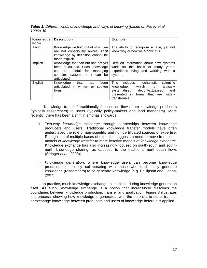
There are many different kinds of knowledge and ways of knowing (Table 1).
Stringer and Reed (2007) argue that by hybridising more explicit scientific knowledges with more implicit local knowledges, researchers and stakeholders could produce more relevant and effective environmental policy and practice to monitor and tackle DLD. Sometimes this may be a process of eliciting, combining and building on tacit, implicit and explicit knowledge from different groups to co-generate new knowledge. More often, this is a process of developing the necessary level of shared knowledge needed to facilitate the exchange of existing explicit knowledge between different groups. Mackinson and Nottestad (1998) suggest that scientific and local knowledge are “grotesquely unequal” in leverage, particularly with respect to policy formation, where the latter is often entirely overlooked because it is often unrecorded. In contrast, the approach proposed here and espoused in the text of the UNCCD values each form of knowledge as complementary.
3 We use the term “local knowledge” in preference to the many alternatives that exist in the literature including lay, practical, extended, community, cultural and traditional knowledge.
17
Table 1. Different kinds of knowledge and ways of knowing (based on Fazey et al., 1006a, b).
Knowledge Form
Description Example
Tacit Knowledge we hold but of which we are not consciously aware. Tacit knowledge by definition cannot be made explicit.
The ability to recognise a face, yet not know why or how we “know” this.
Implicit Knowledge that can but has not yet been articulated. Such knowledge can be useful for managing complex systems if it can be articulated.
Detailed information about how systems work on the basis of many years’ experience living and working with a system.
Explicit Knowledge that has been articulated in written or spoken form.
This includes mechanistic scientific knowledge, which is typically systematised, decontextualised and presented in forms that are widely transferable.
“Knowledge transfer” traditionally focused on flows from knowledge producers
(typically researchers) to users (typically policy-makers and land managers). More recently, there has been a shift in emphasis towards:
i) Two-way knowledge exchange through partnerships between knowledge
producers and users. Traditional knowledge transfer models have often underplayed the role of non-scientific and non-certificated sources of expertise. Recognition of multiple bases of expertise suggests a need to move from linear models of knowledge transfer to more iterative models of knowledge exchange. Knowledge exchange has also increasingly focused on south-south and south-north knowledge sharing, as opposed to the traditional north-south flows (Stringer et al., 2008);
ii) Knowledge generation, where knowledge users can become knowledge
producers, potentially collaborating with those who traditionally generate knowledge (researchers) to co-generate knowledge (e.g. Phillipson and Liddon, 2007).
In practice, much knowledge exchange takes place during knowledge generation
itself. As such, knowledge exchange is a notion that increasingly dissolves the boundaries between knowledge production, transfer and application. Figure 3 illustrates this process, showing how knowledge is generated, with the potential to store, transfer or exchange knowledge between producers and users of knowledge before it is applied.

18
Figure 3. Modes of KM, showing how knowledge is generated, with the potential to store, transfer or exchange knowledge between producers and users of knowledge before it is applied.
New knowledge may be stored in a variety of ways. Preventing the erosion or
complete loss of knowledge is a key challenge for maintaining KM systems in the long term. The internet provides a valuable medium to store, transfer and exchange knowledge around the world between those who have access. However, the information on many websites is lost after the end of project funding (e.g. CLEMDES4 and DISMED5 projects, funded by the European Commission [EC]).
To understand the mechanisms through which knowledge spreads and can be
managed, it is necessary to understand the conditions, processes, and sorts of practices that influence how people learn, and through what channels and sources they increase their knowledge. Learning may occur at the scale of individuals, groups, organisations, “communities of practice”6 or societies, and a vast literature has developed to understand how learning occurs at these different scales (Blackmore, 2007). Of 4 http://www.ist-world.org/ProjectDetails.aspx?ProjectId=f717698201a442e39862a17a5d8cf453 5 http://smap.ew.eea.europa.eu/fol120392/prj956573/ 6 A group of people who create a shared identity by participating in a communal activity (Wenger, 1998).

19
particular interest in the context of DLD are mechanisms that can facilitate learning at community or societal scales, especially through informal networks – “social learning”. A key challenge in KM is to stimulate new exchanges and networks and to tap into existing social networks (Figure 2). In this context, social learning can facilitate shared understanding among and between different types of knowledge through peer-to-peer interactions. By stimulating social learning about DLD M&A, it may be possible to facilitate the adoption of monitoring tools and approaches, and possibly change attitudes, behaviour and underlying world views towards SLM, at a far greater scale than could otherwise be achieved. Nevertheless, it should be noted that some knowledge may be traditionally ‘patented’ and thus undisclosed (e.g. by herbalists/traditional doctors, rainmakers, etc.).
Initiatives to stimulate and facilitate scaling up of conservation agriculture within
the context of NEPAD’s Comprehensive Africa Agriculture Development Programme (CAADP), have facilitated social learning within small community groups about biophysical indicators that can be used to assess trends and extent of DLD and the impact of conservation agriculture practices on soil health and land quality. Local facilitators organize and facilitate interaction between the farmer groups and specialists, generating new knowledge and understanding by blending local knowledge and skills with scientific explanations of underlying processes. Using this sort of approach it may be possible to enable those who have local knowledge to generate new knowledge, based on ancestral knowledge but adapted to current conditions.
Linked to this, there is considerable literature on the role of social networks,
knowledge brokers or intermediaries and their role in the diffusion of information and knowledge (Howells, 2006; Klerkx et al., 2009). For example, agent-based models explain and potentially predict how knowledge is likely to flow through social networks, depending on the characteristics of the individuals through which it flows (see White Paper of Working Group 1 for more details on agent-based models). This may indicate knowledge “clumps” in certain areas where knowledgeable groups of individuals fail to pass on their knowledge.
Box 1 shows how Drynet is performing the role of knowledge broker between
NGOs and CBOs working in the field of land degradation and SLM. NGOs and CBOs may play an important role as knowledge brokers, both in terms of providing information and acting as local communication channels, transforming implicit knowledge into a form of knowledge upon which monitoring programmes can be based. They may then be able to communicate emerging needs to local administrations and link the local community to wider KM systems. Farmers associations can also be effective knowledge brokers. For example, in Namibia, the Forum for Integrated Resource Management (FIRM) works with farmers associations to create a platform where farmers and service providers get together to exchange DLD M&A information and knowledge on a regular basis (see Box 2). While NGOs and CBOs may have the capacity to communicate monitoring information from the local level upwards, this is rarely a direct interest of such organisations and they should not be taken as a “cheap” substitute for state structures that are failing to deliver. At the inter-organisational level, institutions working within a common area must also aim for cooperation as a means to achieve better data exchange and data sharing – a recommendation applicable to all levels of KM.

20
Box 1. Horizontal Knowledge Management Success Stories from Drynet By looking for and learning from success stories, knowledge can be shared more widely. However, the context-specific nature of case studies means that we cannot assume that knowledge will spread to those who need it, as this is dependent upon: i) the extent to which the knowledge is context-specific or more widely applicable; ii) the extent to which the knowledge provides a good return on investment within a reasonable time frame for others to adopt it; iii) the time and/or labour investment a technique or innovation demands; iv) the presence of institutional collaboration, existing networks or non-state agencies that can provide extension services and facilitate exchange of knowledge. Before success stories can become a vehicle for knowledge exchange, careful consideration of why something is a success, what elements are transferable to other contexts and how these stories are conveyed is needed.
Drynet (www.dry-net.org) is a networking and capacity building effort of 14 CSO partners from around the world. Within the Drynet project, success stories (called “inspiring initiatives”) are documented and made available to the public. The stories describe initiatives such as local soil and water conservation techniques, innovative ways to share information at local or national levels, and successes in influencing national policy serving to inspire policy-makers as well as fellow practitioners. To ensure successes are spread effectively, additional activities are planned for horizontal and vertical knowledge exchange.
Another important distinction is the spontaneous spread of successful strategies and practices at the grass roots level, and the role of external agents such as donors and development agencies in actively promoting this diffusion. Experience of Drynet’s partners is that such external organisations can and should play an active but peripheral role in the process by helping to identify successes, facilitating their spread, and providing the necessary enabling conditions. Resource users and local organisations should lead this process which requires enough incentives for local land users to share their knowledge.
A participatory mapping exercise carried out as part of the Birjand Carbon Sequestration Project (part of Drynet), finding cost-effective ways to rehabilitate degraded rangeland.
Box 2. Forum for Integrated Resource Management (FIRM), Namibia In Namibia, a local monitoring system involving community members was first developed for the monitoring of wildlife in the Grootberg conservancy in north-western Namibia (Stuart-Hill et al., 2005). This approach was adopted and further developed into a tool that can provide local farmers with relevant information (Klintenberg et al., 2003, 2008). The methods developed are specifically designed for communal farmers and their unique requirements, based on indicators identified by the farmers themselves. The local level monitoring (LLM) system provides detailed, relatively immediate and useful information needed for improved management of rangelands (Klintenberg et al., 2008).

21
The recording of observations made by farmers is an important part of the system. Most farmers, as part of their normal practices, make decisions based on one or several environmental (or social) indicators. However, observations are seldom systematic or recorded. Information is often lost, as the memories fade and get mixed up over the years. By recording his/her observations, the farmer obtains a better understanding of how variable environmental conditions, e.g. amount and seasonality of rainfall, influence the state of the environment and his/her agricultural production. Secondly, by recording each observation in the prepared field guide, a historical record is created, which allows the farmer to compare conditions over the years and also to compare with fellow farmers in community Forums for Integrated Resource Management (FIRM) or comparable CBO (Kambatuku, 2003b; Klintenberg et al., 2008; Kroll and Kruger, 1998). FIRM is an approach designed to put rural communities in the driver’s seat in terms of their own development. It involves a CBO of rural farmers taking the lead in organising, planning and monitoring their own development while coordinating the interventions of their service providers (Kruger et al., 2003, 2008; Stringer et al., 2007). The joint discussion of results amongst farmers in a community FIRM is one of the key features of the LLM system, providing an information base for joint planning and decision-making. Information generated through this farmer-driven monitoring is ideally forming a central part in planning and decision-making made by FIRM groups (Kruger et al., 2008). At the same time, having a record supports the farmers in their communication with service providers, other natural resource managers and policy-makers. Research combining scientific observations and traditional knowledge held by local farmers has been carried out in central northern Namibia by various ‘boundary organisations’ (Klintenberg et al., 2008; Klintenberg and Verlinden, 2008; Verlinden and Dayot, 2005; Verlinden and Kruger, 2007). By comparing results from a national land degradation monitoring system (Klintenberg and Seely, 2004) with local perceptions of environmental change, Klintenberg et al. (2008) could show that local perceptions corresponded with environmental changes identified by national monitoring. However, it was also shown that information given by local farmers revealed a more complex picture of causes and effects of environmental changes compared to the variables used for national-level monitoring. It was therefore concluded that traditional knowledge held by local farmers could contribute meaningfully to improving national indicators when communicated through inter-level linkages. This example illustrates the value of integrating traditional knowledge into scientific investigations of environmental change and land degradation based on an inter-level exchange of information. Integration of traditional knowledge improved the understanding of researchers and the local community of the complex systems being investigated. By involving the local equivalent of a FIRM and ensuring information flow between community members and researchers, results can be used by all participants (e.g. Seely, 1998; Seely et al., 2006, 2008). Moreover, as the research results are conveyed to different levels, communication pathways remain open by involving the FIRM and its members and service providers as much as possible.
Finally, appropriate methods and institutions are necessary to facilitate learning
between local, regional, national and international players, and among different stakeholder groups at each level. The following sections examine a range of processes and institutional structures that have the capacity to facilitate the co-generation, transfer and exchange of knowledge between different groups at different spatial and temporal scales. Broadly, these processes and institutions for KM can: i) help identify and share good practices and build capacity for DLD monitoring at different scales and in different contexts; and ii) create knowledge networks to share lessons learned and monitoring data between local, regional, national and international stakeholders, and between stakeholders working at each of these scales. We shall refer to information flows
22
between stakeholders at any one of these scales as “horizontal” KM, and to information flowing between these scales as “vertical” KM.
In summary, KM is a process that not only involves the generation and exchange
of data or information: it also requires the development of mechanisms that promote a change in understanding by the individuals involved, and the co-generation of new knowledge through the networks and participation of a wide range of individuals. KM involves maintaining stocks or reservoirs of knowledge, for example, by creating institutional memory and preventing outdated knowledge from leading to counter-productive responses to DLD. KM requires sustainable and efficient means of access and/or brokerage.
2.4. Knowledge Management for Monitoring DLD
I. Horizontal local knowledge management The following section examines how these new methodological and institutional approaches may be able to facilitate more effective horizontal KM between diverse local stakeholders. It then looks at how this can be used to both monitor and respond to DLD at the local level. It will assess the current capacity for local stakeholders to monitor and assess DLD and discuss how capacity and incentives may be further developed. It will explore methods for facilitating knowledge exchange between diverse stakeholder groups in a given locale, and between local stakeholders in comparable contexts internationally. Finally, it will explore the potential benefits of integrating local and scientific knowledge for DLD M&A, and some methods that exist to achieve such integration. A number of case studies have been selected to illustrate these points (although every effort have been made to ensure regional representation, most examples are from Africa where DLD problems are most acute).
DLD can only be determined in relation to the goals of the management system
at the time of investigation (Abel and Blaikie, 1989), and in the context of a specific time frame, spatial scale, economy, environment and culture (Warren, 2002). Although this implies a focus on provisioning services, if land degradation is conceptualised as a reduction in the ecosystem service potential of the land (c.f. UNEP, 1997), it is possible to define land degradation as a reduction in or loss of cultural and regulating services, in addition to supporting and provisioning services (Tarrason et al., under review). As such, changes in landscape aesthetics (e.g. afforestation) that reduce their recreational value (e.g. by obscuring views) may be considered as land degradation alongside more commonly recognised processes such as soil loss or thorny bush encroachment. For a stakeholder who primarily values such a landscape for recreation or spiritual fulfilment, the loss of this characteristic would constitute a loss of function and hence land degradation. An ecosystem services approach to land degradation recognises that land has multiple functions, and is valued differently by multiple stakeholders who have multiple, and often overlapping and/or competing values and uses for land. A reduction in the provision of one ecosystem service may be considered land degradation by one stakeholder (e.g. grazing due to thorny bush encroachment to cattle owners), but may create new ecosystem services for other stakeholders (e.g. the creation of browse for goat owners) (Photo 1). The fact that land degradation is so context-dependant is a major challenge for assessing its severity and extent (Warren, 2002). However, through

23
the lens of ecosystem services, it may be possible to spatially quantify changes in the status of multiple functions that each represents different aspects of land degradation.
Local knowledge, both current and historic, is therefore essential to monitor land
degradation as it is uniquely adapted to the contexts in which it has been developed and applied and so can diagnose the sorts of land degradation issues most relevant in any given locale. In addition, indicators7 based on local knowledge are likely to be familiar to land managers who are likely to have the capacity to use them without specialist training or equipment (see White Paper of Working Group 1 for a more detailed account of the role of indicators in land degradation M&A). By supporting the development of grassroots indicators, it may therefore be possible to reduce barriers to more widespread uptake of land degradation monitoring. If clear links are also made between monitoring and land management, it may be possible to create incentives that could facilitate more widespread monitoring by affected communities. However, the dynamic and context-dependant nature of land degradation means that monitoring needs and relevant indicators may change over time.
Photo 1. Thorny bush encroachment in Boteti, Botswana: a resource for browsers (Photo: R. Chanda, 2009).
Although no evidence exists to assess the current capacity for land degradation monitoring among affected communities, there is evidence that land managers have a comprehensive and nuanced capacity for monitoring, even in recently established agricultural systems. Boxes 3 and 4 show the depth of often implicit knowledge about indicators in rangelands in southern Africa that were recently made accessible for livestock production, and which enables land managers to monitor and respond to land degradation. Similar results have been found through research into monitoring by communities elsewhere (e.g. Kipuri, 1996; Niamir-Fuller, 1998; Oba and Kaitira, 2006; Ngugi and Conant, 2008; Raymond et al., 2009).
7 We define an indicator as a physical, chemical, biological or socio-economic measurement, statistic or value that can be used to assess natural resources and environmental quality.

24
Box 3. Horizontal Local Knowledge Management Using Indicators in Botswana The majority of rangelands in semi-arid Botswana have only been accessible to livestock grazing through borehole access to ground water since the 1960s (Cooke, 1985; Sporton and Thomas, 2002). Yet, there is widespread knowledge and use of land degradation indicators by local pastoralist communities. Reed et al. (2008) elicited a total of 140 different indicators from pastoralists in three semi-arid rangelands in Botswana. The majority of indicators used by these groups were evaluated through empirical work (e.g. decreased grass cover and soil organic matter content, and increased abundance of the thorny bush Acacia mellifera and unpalatable thatching grass). Although knowledge of land degradation indicators appeared to be thinly spread (on average, individuals were able to describe just 6 indicators), interviewees who reviewed indicators in focus groups were familiar with the majority of those described, and in some places indicator knowledge was positively correlated with formal educational status (i.e. the capacity to articulate their knowledge). This suggests that for many land managers, knowledge about land degradation indicators is either tacit or implicit (see Chapter 2.3.). For this reason, it is easy for external assessments to underestimate the capacity for affected communities to monitor land degradation. Land degradation indicators have been integrated with management options in a decision-support manual8 for pastoralists and extension workers (Reed and Dougill, in press). The assessment procedure is qualitative, using “wheel diagrams” to identify problems using a combination of pre-selected “early warning” indicators and supplementary indicators selected by users (see figure (a)). The procedure is relatively flexible and designed to make recording and interpretation of results simple for users. Short textual descriptions of indicators are illustrated with photographs representing healthy and unhealthy rangeland states (see figure (b)) to help identify key species where necessary. Each indicator is cross-referenced to a range of management options to suit different budgets and time frames.
� a) Example of a wheel diagram for recording measurements of “early warning” land degradation indicators; and b) example page from Study Area 3 manual showing indicator description.
8 Literacy levels are high in Botswana: 65% and 98% in two of the study areas (rates not known for third study area but believed by key informants to be above average) (Central Statistics Office, 2004).
a) b)

25
Box 4. Local-level Land Degradation Monitoring and Decision-support in Namibia This local level monitoring system, adapted from community-based wildlife techniques (Stuart-Hill et al., 2005) is a set of environmental indicators identified by local farmers based on their information needs (Klintenberg et al., 2003). The easily-measurable indicators provide farmers and resource users with the required information to make management decisions, and monitoring costs are minimized by selecting indicators that are normally being measured (such as yield or animal health). Through regular monitoring, farmers are better equipped to detect land degradation patterns or trends that may threaten agricultural activities. Data collection alone is not sustainable and farmers are very reluctant to continue with it for a long period. Therefore, quarterly events are facilitated where farmers can reflect on their data. Extension agents assist farmers to synthesise, analyse, and interpret their data, followed by larger community meetings where the data are presented and discussed. From these discussions, farmers develop an improved understanding of the limitations and potentials of their rangeland resources and have an opportunity to develop possible options on how to deal with the limitations of their rangelands. Based on community consultations in Namibia (Klintenberg et. al., 2003), four indicators were developed which farmers believe provide them with the necessary information to make timely management decisions. These are: 1. Livestock condition: livestock condition and rangeland productivity, whereby livestock conditions are closely linked and can serve as an early warning on the state and condition of the rangeland (see example below). 2. Rainfall received over time: amount and distribution of rainfall was identified as the most important factor influencing changes in vegetation quality and quantity, as it has a direct impact on the amount of fodder available in the rangeland. 3. Rangeland fodder availability: It is important for farmers to know how many animals to keep on their rangelands during a specific period. Since rainfall variability is directly linked to fodder variability, both in terms of time and space, a good indication of the dry season as early as possible will help farmers to determine how many animals they can keep with the available fodder and mitigate the impacts of having too many livestock for their available fodder sources. 4. Rangeland condition and bush density: the condition of the topsoil, prevalence of perennial grasses and bush densities all have a direct impact on rangeland productivity and need to be monitored by farmers over time in order to be able to assess the long-term impact of their short-term management decisions. Example of an Indicator: Livestock Condition The condition of livestock reflects the condition and productivity of rangelands and is independent of age, breed, sex and body mass of the livestock. This indicator is measured by a random selection of 25 animals from a farmer’s herd. The field guide provides a series of photos showing livestock according to five different condition classes, ranging from 1 (very lean) to 5 (very fat).
Condition classes of livestock from 1=very lean (far left) to 5=very fat (far right). The farmer’s livestock is compared to the pictures and values assigned to each selected animal. The average herd condition is calculated and the number of animals in each class recorded on a monthly basis. Of particular interest is monitoring the number of animals in the poorer condition classes as they will need special treatment during the dry season to prevent them from dying.

26
By transferring the data to graphs on a regular basis, farmers can easily visualise the fluctuation in livestock condition over the year and monitor the number of animals in the poor condition classes during the dry season which will help them to make timely decisions to prevent these animals from dying.
0
10
20
30
40
50
60
70
80
90
100
Aug'05 Oct'05 Dec'05 Feb'06 Apr'06 Jun'06 Aug'06 Oct'06Months
%
0
0.5
1
1.5
2
2.5
3
3.5
Aug'05 Oct'05 Dec'05 Feb'06 Apr'06 Jun'06 Aug'06 Oct'06Months
Bod
y co
nditi
on s
core
Left: Percentage of cattle in condition classes 1 and 2 (very poor to poor) in three villages in the eastern communal lands of Namibia; Right: Average livestock condition scores in three villages in the eastern communal areas of Namibia. The following options and solutions were developed by farmers in the eastern communal lands of Namibia, based on their own local level data: 1. Market all marketable livestock early in the dry season when livestock condition is still good and prices are high. 2. Seek alternative grazing resources for excess livestock and move there as early as possible. 3. Provide good supplementary feeds to prevent too quick a decline in livestock condition during the dry season. 4. Buy additional fodder to provide for those animals in poorer condition classes. 5. Combine smaller livestock herds to practice rotational grazing and rest overgrazed areas. 6. Better distribute water points to ease pressure on already denuded rangeland around existing permanent water points.
By accessing local knowledge on land degradation monitoring, it is possible to
elicit a far broader range of indicators than through published lists, for example by encompassing vegetation, soil, livestock, wild animal, and socio-economic indicators (Reed et al., 2008). Although these indicators may only be locally applicable, this contrasts with the majority of degradation monitoring manuals aimed at pastoralists which tend to focus on vegetation and/or soil indicators (e.g., Esler et al. 2005) despite evidence that reliance on a narrow range of indicators may produce misleading results for degradation assessment. In contrast, the breadth of indicators used by affected communities matches the call by the UNCCD (1994, Article 16 (c)) for “integrated sets of physical, biological, social and economic indicators”. For example, this allows rangeland fragmentation even in absence of habitat loss to be viewed as a degradation process, limiting the options of people and animals (Hobbs et al., 2008).
Given the clear benefits of local knowledge for land degradation monitoring, it is
important to determine how to further build capacity. NGOs and CBOs can clearly play a significant role (see previous section and Boxes 1 and 2). Broader institutional reform may also be necessary. For example, there has been a lot of research to try and understand conditions necessary for long-term M&A of natural resources under common

27
property regimes (Baland and Platteau, 1996; Ostrom, 1990). Two general lessons are evident. Firstly, reasonably small commons with clear boundaries on resources and resource users allow individuals to continually monitor conditions as part of their daily activities, by keeping the transaction costs of monitoring low (Quinn et al. 2007). Secondly, traditional institutions tend to have high levels of social capital and facilitate community empowerment and actions. Such mechanisms are built on trust and a history of negotiation and decision-making that can overcome the problems of free-riding or the absence of well-defined property rights (Katz, 2000). That is not to say that traditional common property regimes are a panacea for the problems of land degradation. There is evidence for success and failure in the management of natural resources using all types of management regime, from common property to private property (Acheson, 2006). However, the increasing pressure traditional regimes are under is likely to have reduced their effectiveness. Increasing populations, technology change, global markets and insecure land tenure have all contributed to the failure of traditional common property regimes to prevent resource degradation (Attwell and Cotterill, 2000; Campbell et al., 2001). Box 5 shows how the Government of Botswana has increasingly adopted top-down approaches to land degradation M&A in the context of the privatisation of communal rangeland. In contrast, re-coupling communities to their environment can create a vested interest in long-term management of resources (Twyman et al., 2001). For example, the BIOTA Southern Africa project9 has trained local “para-ecologists” to carry out degradation assessments and monitoring, allowing communities access to up-to-date information that can and is used to inform local management decisions (Box 6; Schmiedel, 2006). Box 5. Approaches to DLD M&A in the Context of the Privatisation of Communal Rangelands in Botswana The piosphere (grazing gradient approach) forms the basis for rangeland monitoring under the Ministry of Agriculture in Botswana (GRM, 1986), and explicitly identifies significant changes in vegetation composition and structure with increasing distance from the waterpoint. Without exception, the area immediately surrounding the waterpoint experiences heavy trampling and grazing pressure and appears as open expanse of bare ground. Wind-blown sand creates the impression of a devastated area in which recovery of the vegetation appears unlikely. Beyond this zone, bush encroachment dominates, resulting in increased shrub cover and/or density at the expense of grasses. The piosphere approach has been used to establish trends in the state of Australian arid and semi-arid rangelands (Pickup et al., 1998). In Botswana, the context of range assessments is very different. In the initial formulation of Botswana’s Tribal Grazing Lands Policy (TGLP), there was a requirement to follow recommended stocking rates, and also the payment of nominal rents to District Land Boards. In reality, neither has been enforced, such that stocking rates and resultant range conditions on ranches and cattleposts differ greatly over short distances and are typically characterised by extensive bush encroachment. Monitoring is therefore the prerogative of the livestock owner with there being no effective mechanism for limiting stocking rates.
In this respect, the focus of rangeland monitoring and management schemes on communal areas appears misplaced. Successive livestock development policies (Tsimako, 1991) and consultancies (e.g. Carl Bro, 1982; McGowan, 1987) in Botswana have sought to effectively privatise tribal grazing land, with the intention of making the individual borehole and/or livestock owners directly accountable for the widely perceived costs of overstocking – namely rangeland
9 www.biota-africa.org

28
degradation and declining secondary productivity (of beef cattle). This has not led to limits on stocking rates or improvements in animal productivity or range condition on ranches, and the focus remains centred on communal areas.
This situation is unlikely to change unless the context of livestock-keeping changes in Botswana. The lack of penalties for heavy stocking rates and deteriorating range condition on private (or near-private) ranches and cattleposts, and the lack of any legislation to enforce it, means that range monitoring has no value beyond the land owner’s (user’s) perception of it. Coupled with the issue of dual grazing rights, the focus of rangeland monitoring on communal areas appears unjustified. It misses entirely the inequities of resource use distribution and appears nested in the outdated and much criticised ”tragedy of the commons” thesis.
The greatest potential return from rangeland monitoring may lie within ‘Community Trust’ areas and through community based natural resource management (CBNRM), although, as emphasized above, the fact that cattlepost owners located within these areas remain outside of any management recommendations greatly undermines their value. It is perhaps ironic that in Botswana, the movement away from open access regimes has in fact done little to promote rangeland monitoring or management. Beyond the perception and desires of individual (or syndicated) ranch or cattlepost owners, there is no legal requirement to monitor and manage and no legislated system of penalties for failing to do so.
Shared resource regimes that typify CBNRM initiatives therefore have the most potential and incentive to monitor and manage rangeland resources. In Kalahari, the trend towards increasingly fenced-in rangelands and livestock-dominated systems (rather than multiple use systems such as those that are wildlife-based) does not bode well. Indeed, some forty years after Hardin’s (1968) thesis, the twin pillars of official livestock policy and privatization/commercialisation show no sign of having run their course, but have in fact led to an entirely unregulated closed access ranch system of management in which both local knowledge and any form of equity (in terms of access to natural resources) has been severely eroded.
Box 6. Para-ecologists as Facilitators of Knowledge Exchange between Researchers and Land Users in Africa You don’t have to be an academic to manage valuable knowledge for sustainable use at the local level. BIOTA AFRICA is currently the largest international and interdisciplinary research project in Africa that examines the ecological and socio-economic causes and changes in biodiversity and their effects (Schmiedel, 2006). As the generation of academic knowledge alone is not sufficient to safeguard local biodiversity, scientists from Africa and Germany developed an annual training programme for representatives of rural communities. In block courses of several weeks duration, young people between the ages of 20 and 40 are trained in monitoring biodiversity and analyzing the effects of land use in humid, sub-humid, semi-arid and arid African environments. Para-ecologists have no formal tertiary education but receive capacity development over a period of more than five years during training courses and while working in the field with researchers. The training programmes include the collecting, conserving and determining of plants and animals. Para-ecologists learn to perform standardized seasonal monitoring and they learn to exchange information with other community members, schools, local administrations and scientists. Para-ecologists are also introduced to the use of common technical aids such as Global Positioning System (GPS), digital cameras, computers, weather stations, maps, etc. These courses are accompanied by the experiences they gain while working as paid para-ecologists under the supervision of scientists from different fields. In the course of their work, para-ecologists experience the importance of monitoring their own natural environment

29
(livestock and rangeland condition). Para-ecologists can become key KM bearers in their communities. Under the guidance of researchers, para-ecologists also play a vital role as co-generators, co-maintainers and disseminators of knowledge, information and data. Thus, the former top-down approach between those who produce information and those who need this for their livelihoods now also interlinks with a horizontal KM system. Field experience during the past five years shows that the success of the para-ecologist training programme is dependent on the individual commitment of the trainers and the young trainees. Whereas some para-ecologists found qualified jobs in the environmental sector, others remained in the project as para-ecologists, working in rural communities (Krug et al. 2006). Sustainability of the approach beyond the life of the funded project is dependent upon the para-ecologists being integrated into a local institution.
Photo courtesy of Ute Schmiedel.
At the end of each annual training course, the para-ecologists in BIOTA AFRICA are awarded a certificate after passing an exam.
To further build capacity, there is an urgent need to identify and share good
practices in M&A amongst affected communities, both within given locales and between affected communities in similar contexts internationally. This is especially urgent given the erosion of local knowledge in many affected communities. The long-term retention, implementation and evolution of inter-generational local knowledge are threatened by a range of factors. For example, the sedentarisation of nomads in the semi-arid and arid north-eastern Sudan is leading to a loss of environmental knowledge as it becomes less relevant to successive generations (Akhtar and v. Schutzbar, 1994). Formal education may lead to further losses, given the low value afforded to local knowledge in many education systems. Elsewhere, pressure to continue providing more food for rapidly growing populations has compelled many communities to abandon valuable local knowledge and skills in monitoring and responding to land degradation (both its use and transmission to future generations). Although there have been many successful attempts to protect local knowledge through documentation and inventories (e.g. Sallu et al., 2009), knowledge only gets shared, preserved and developed if it is used.
Identifying good practices is vital. Local knowledge cannot be accepted
unquestioningly (Reed et al., 2006). Local knowledge of land degradation indicators may not always be sufficiently accurate or reliable for objective degradation assessment (Reed et al., 2008; Box 3), nor is it always gender or class neutral. For example, Tlhalerwa (2006) revealed the gendered nature of local knowledge in Botswana and cautioned that the use of local knowledge may perpetuate or even exacerbate gender gaps. Equally, scientific knowledge should not be uncritically accepted without evaluating the uncertainty and associated value judgments in the claims being made

30
(Davis, 2005; Failing et al., 2007). For example, in Australia, Aboriginal knowledge has been repeatedly used to expose the limitations of short-term ecological research (Baker and the Mutitjulu community, 1992). If local and scientific knowledge are considered to be equally valid, it is necessary to subject each to an appropriate level of scrutiny before considering what exactly may be integrated to deliver what may be termed “socially robust” indicators that are both understood and used by stakeholders (Nowotny, 2003).
A variety of methods exist for evaluating, combining and integrating local and
scientific knowledge. In mixed methods research designs, qualitative research is traditionally used to access local knowledge in an exploratory mode to generate hypotheses, which are then tested using more quantitative methods (Holland and Campbell, 2005). For example, local knowledge of land degradation indicators may be compared against evidence from research literature (c.f. Reed and Dougill, 2002). However, such analyses are problematic due to their implication that scientific knowledge is superior and can be used to “validate” local knowledge. In contrast, affected communities can systematically and critically evaluate local and scientific knowledge of land degradation indicators themselves, using participatory decision-support tools such as multi-criteria evaluation (c.f. Ferrarini et al., 2001). For example, using multi-criteria evaluation, Reed et al. (2008) evaluated local knowledge of land degradation indicators with local communities in focus groups, evaluated the indicators deemed most robust through field-based research, and then enabled local communities to evaluate the results of this research through further structured discussions in focus groups. Through such an iterative approach, it may be possible for affected communities and researchers to learn from each other to develop more effective approaches to monitor land degradation. Finally, “mediated modelling” and “dynamic systems modelling” build on local knowledge of how complex systems work, basing models of land use systems on a more comprehensive knowledge base relevant to land manager needs and priorities (van den Belt, 2004; Prell et al., 2007; Dougill et al., under review; Fraser et al., under review). Dynamic systems models also allow users to vary the assumptions upon which the models are built, exploring how sensitive a system is to uncertainties and gaps in knowledge, and identifying potential “tipping points” and “leverage points” in the system where land management or policy decisions may have disproportionate effects. Many of the variables included in such models have the potential to be effective land degradation indicators, and by varying their values it is possible to evaluate the relative sensitivity of indicators that are based upon an integrated knowledge base.
After having identified good practices in land degradation monitoring, integrating
local and scientific knowledge where relevant, it is necessary to share these lessons as broadly as possible among affected communities. To do this, different mechanisms are relevant at different scales. At local scales, there are a wide range of participatory tools that can achieve this. For example, Reed et al. (2008) used village focus groups and multi-criteria evaluation to disseminate indicator knowledge amongst the affected communities they worked with (Box 5). At district scales, Raymond and Brown (2006) used participatory mapping to integrate local and scientific knowledge, expressed as values, for conservation areas in Victoria and South Australia. They were able to measure the level of spatial agreement and disagreement between local and scientific conservation values to prioritise investment in environmental management. Local communities represent an essential source of information for many of the variables relevant to land degradation monitoring, some of which cannot be collected through traditional research methods or are difficult to obtain within the timeframe of projects.

31
Participation should be viewed as a long-term relationship between researchers, policy-makers and other stakeholders in which trust can be fostered as participants begin to understand each other’s values and knowledge, assisted by the right tools to reach negotiated goals (Reed, 2008). This view is underpinned by a philosophy that emphasises empowerment, equity, trust and learning. For horizontal KM to be effective, it must be inclusive, have clear objectives from the outset, and should not overlook the need for highly skilled facilitation. Participatory approaches to KM should be mainstreamed in the institutions charged with land degradation monitoring, creating organisational cultures that can facilitate processes where goals are negotiated and outcomes are necessarily uncertain. There is increasing evidence that participatory approaches are becoming embedded in the institutional cultures of research funding agencies, such as in EU research funding programmes and UK Research Councils. However, there is a need for research and development initiatives to increasingly be initiated and co-designed with stakeholders, incorporating their participation from the beginning right through to monitoring and evaluation.
There are many limitations to participatory approaches (for a detailed critique see
Cooke and Kothari, 2001), a principle one being the limited spatial scales at which they can operate effectively. Focus groups and field visits have been used as tools to exchange local knowledge between land users from different countries (see Box 1). However, most KM systems share local knowledge at this sort of scale using Information Technology (IT) (for example, see WOCAT as described in section 2.5). However, IT has its drawbacks: it is not accessible to everyone, and though it makes information widely accessible, knowledge exchange takes place most effectively from person to person.
Finally, for DLD M&A to be adopted by land managers, it must contribute towards
decision-making processes, providing real benefits to those who make the measurements. Decision-making based on reliable and timely information by resource users and managers in drylands will become more important under future climate change. However, conventional decision-support systems are often difficult to implement and information derived is too generic and too late for local land users to make appropriate proactive decisions (Klintenberg et al., 2008). For this reason there are a growing number of attempts to develop decision-support tools in which land managers can use the results of M&A themselves to enhance the sustainability of land management and agricultural production (see Boxes 4, 7 and 8). Organizing and recruiting stakeholders to these activities – and keeping their interest during monitoring and decision-making processes that unfold slowly – is a particular challenge when the object of M&A is relatively intangible and in the absence of a perceived ‘crisis’ or ‘threat’. Box 2 suggests that farmers may be motivated to continue collecting data if it feeds into immediate decision-making. Others may want to be assured that results will feed into higher level decision-making processes at the national scale (Pahl-Wostl and Hare, 2004).

32
Box 7. Development of a Concerted Action as a Tool of Knowledge Exchange to Support the Northern Mediterranean Action Programme to Combat Desertification (MEDRAP) The EC MEDRAP Concerted Action (2001-2004) has been among the first projects to specifically address the involvement of stakeholders and researchers within the UNCCD context. Conceived as a support to the main needs expressed by the Annex IV Countries (at that time, Greece, Italy, Portugal, Spain and Turkey), MEDRAP’s main aim was to support the elaboration of the UNCCD Sub-Regional Action Programme to Combat Desertification in the northern Mediterranean countries. Its most relevant feature was the involvement of institutional stakeholders (UNCCD Focal Points, representatives of National Committees to combat desertification, institutional authorities, NGOs) among the project partners who, as such, participated actively since the initial stage of problem definition; together with the researchers, they discussed and identified common priority issues which constituted the topics of as many thematic workshops in an effort to find common solutions. All partners involved considered MEDRAP a very positive experience that greatly increased the opportunity to meet, discuss and exchange information. In addition, a large stakeholders network involving researchers, institutional officers and NGOs was set up at the beginning of the project which included about 800 contacts from the countries concerned. The aim was to involve them before each workshop so as to collect information from them and involve them via questionnaires and discussions that could enrich the workshop sessions. Responses to this effort have been very few (10%) and mainly from organisations who were already directly involved in research related to desertification. Source: Enne et al., 2004.
Box 8. Participatory Approach and Horizontal Knowledge Management of a Demonstrative Project to Fight Desertification in North Africa The Short and Medium-term environmental Action Programme (SMAP) demonstration project on Strategies to Combat Desertification in Arid Lands with Direct Involvement of Agro-pastoral Communities in North Africa involved restoration of vegetation cover with drought-resistant species in highly degraded rangelands of Morocco and Tunisia to mitigate desertification processes and improve productivity of rangelands. One of the key axes of the project approach was the improvement of the interactions between the local stakeholders involved in livestock management, rural development and environmental protection. The approach adopted by the project considered participation as a means, goal and tool. In theory, local participation was understood as a process which must start from the development initiative conception. The manner of carrying out the launching of the process was based on the fact that each society has its own culture which influences its decision and communication patterns. The project was based on the principle that external researchers cannot always identify the local population’s needs and priorities, or the best way to respond to it. The local communities in the project area in Morocco and Tunisia have invaluable experience and a particular comprehension of their own environment. The strategy of the project strived for equal access between the men and the women of the concerned area to the management and control of natural resources. One of strong axes of the project strategy resides in research and the implementation of the partnership, which makes it possible to bring the actors who are ready to invest themselves closer together, to establish a close link between needs and resources, and to better take into account the real situations of the arid regions while covering all their complexities (difficulties, divergences, conflicts).The partnership practices are concretized through dialogue and

33
consultation in order to be able to establish bonds between the actors and to lead to joint common projects. Within a new framework, the project has promoted new sustainable management systems of agro-environment rehabilitation interventions, and from that, the diversification of the economic activities and the implementation of new income generating activities. This was based on the identification of the potential of the natural and human resources in the territory. Certain socio-economic and environmental constraints hindering the potential success of the project were identified at the beginning of the intervention, including low associative level amongst local farmers, individualism, minimal role of rural women, illiteracy, incapacity of the extension services to apply participatory approach methods, and lack of attention to interpersonal communication. Technical staff were subsequently trained in participatory methods, interpersonal communication skills and gender sensitization. Role-playing exercises made it possible for participants to appreciate the importance of interpersonal communication as a tool for the mobilization and participation of the populations. An evaluation of the participative approach in the project showed a greater mobilization of the populations when cooperatives were formed, and an increased participation of women through income-generating activities. The high level of population mobilization allowed for relevant decision-making within the project, such as the rallying of a new rural district into the project, the increase in the area of fodder shrubs plantations through the addition of private lands. This is a direct result of involvement of the population in the project. Favourable indicators of the beneficial effects of the participation approach included: i) the target populations maintained the cultural values associated with previous community management; ii) local capacities were reinforced by practices of collaboration between the government institutions and local populations; and, iii) conflicts between local stakeholders were eased. The project evolved progressively since its implementation and remained very flexible on the solutions needed to meet the needs of the populations. The participatory process required time and effort. Awareness campaigns are always necessary to disseminate the project to the public. More often than not, the extension services of agricultural directorate and local NGOs have contributed to reinforcing the community capacities in the participatory programming. The community must pass through a long process of training and confidence building in order to be able to fully benefit from the new resources that it will receive and manage directly. Source: Bellal, 2007.
II. Horizontal national knowledge management
Monitoring and assessment of DLD also take place at the national level, where governments must utilize scientific, socio-economic and technical data and information for strategic planning, priority setting and national environment and development planning. There are a number of challenges that governments face in managing knowledge about DLD at the national level, including:
• inadequate scientific, economic and technical data collection and information exchange for monitoring and assessing DLD;
• utilizing the information collected to build institutional memory and the knowledge gained for national planning;
• poor delivery of information and knowledge for local SLM; • inadequate recognition for and mobilization of local indigenous knowledge; • poor awareness of the nature, causes, consequences and remedies for DLD; • poorly organized information bases maintained by diverse information providers,
mainly at the national level, unable to deliver locally- and policy-relevant

34
information (South African Department of Environmental Affairs and Tourism, 2004); and,
• poorly or unconnected national environmental data sets (where they exist), where most of the information gathered stays exclusively with the agency or officer in charge, resulting in duplication of efforts.
The overarching issue faced by developing countries is lack of capacity. Capacity
affects responses to and the effectiveness of monitoring and knowledge exchange, along with the ability to effectively implement treaties. This key problem, identified by virtually all studies and reports, ministries, agencies, NGOs and others, relates to the lack of institutional, financial and human capacity to address physical, human resource and skill requirements. Almost all of the literature on implementation of the MEAs (e.g., Haas et al., 1993; Keohane and Levy, 1996; Victor et al., 1998; Weiss and Jacobsen, 1998; Schreurs and Economy, 1997; Esty et al., 1998; VanDeveer and Dabelko, 2001; VanDeveer and Sagar, 2005) identifies capacity building as a central factor, a well-known, yet important and often overlooked, factor.
One of the challenges in addressing capacity building has been that various
capacity-building programmes instituted in different countries and regions have been sectoral in nature or related to a specific treaty, whether it is the UNCCD, the CBD, the UNFCCC or others. But many of these fail to address the need for cross-sectoral capacity as well as the need for capacity in the “upstream” aspects of policy-making, including agenda setting, framing, analysis and policy development and design (VanDeveer and Sagar, 2005). Some of the specific problems include:
• limited awareness by politicians of the significance of international
environmental issues for the national/local context; • limited scientific and technical capacity; • limited knowledge on integrated land management practices; • inadequate coordination of MEA implementation activities at the national
level; • limited in-country MEA implementation training; and, • overall, a limited number of sufficiently trained people in national
governments who can understand and facilitate the greater transformational learning required for a complex socio-ecological problem such as DLD.
Another challenge, which builds on and overlaps with capacity building, is the
lack of collaboration and sharing of information. When it comes to monitoring and knowledge exchange as part of MEA implementation, there is a need to collaborate on or coordinate activities at the regional, national and local levels. At the local level, the impact of local actions, activities and lifestyles and NGO, community and education projects do not usually take global impacts and implementation of relevant MEAs into consideration. Conversely, since many MEAs do not take public participation sufficiently into account, there is little incentive for governments to do so. Unlike other MEAs, the UNCCD is often labelled as having a “bottom-up” approach (Danish, 1995). The UNCCD text includes numerous references to the role of non-governmental actors, in stark contrast to others like the UNFCCC text which has almost no references to non-governmental actors. Betsill and Corell (2001, 2008) find that non-state actors did influence the negotiation of the Convention. However, the level of knowledge and understanding of the UNCCD and its National Action Programmes (NAPs) by non-

35
governmental actors is still seen as inadequate by many. Methods of improving the level of knowledge of NAPs among non-governmental stakeholders need to be designed according to the context in which they are supposed to operate (Italian Association of NGOs, 2006). Therefore, collaboration among local entities, civil society and national governments needs to be improved so that there is a true bottom-up approach in implementation as well as negotiation.
Collaboration or coordination at each of these levels is compounded by the
challenge of vertical integration between the global, regional, national and local levels (Figure 2). This is not helped by the fact that the MEAs themselves are only now coming to terms with the need for better coordination between their Secretariats, reporting requirements and other policies. In many cases, there is a lack of synergy between domestic environmental priorities and the objectives of the UNCCD and other MEAs and the actions required to be addressed. The pressure to meet MEA obligations has led to the establishment of national coordination mechanisms that are often geared more towards satisfying MEA obligations, mostly through reporting, without serious effort to take the global message to the local level. Where effective coordination exists, it is often at the project level, but this can neglect the need for coordination at the political and institutional levels that is essential for a holistic response to environmental issues (Chasek, 2008). For example, there are situations where the ideas in the NAPs are not incorporated into Poverty Reduction Strategy Papers and other strategies that governments must develop. As Pearce (2006) notes, the NAPs are one among many sustainable development plans that ministries responsible for the environment must develop, and their priorities can be lost among the others (especially when the ministry in charge of the NAP is not the one that negotiates with donors).
Finally, the UNCCD addresses a multiplicity of interconnected environmental,
economic and social issues, which cut across the responsibilities of different government agencies and governance levels. An NAP that adequately addresses these interconnected issues would need to bring together the fragmented knowledge base, bridge the science-policy divide, synthesize and harmonize the abundance of information available, and would require coordinated activities at the national level that will also interact with the community and international levels.
There are several options available to improve KM at the national level. To
ensure that knowledge feeds directly into the policy process, KM needs to be integrated into the institutional structures and mechanisms at the national level. To address the need for interdisciplinarity and trained personnel who can understand a complex socio-ecological problem such as desertification, there is a need for better interdisciplinary training and educational programmes in universities as well as in internal training in governmental departments (see Box 9). Box 9. Interdisciplinary Programmes: the Master's in Development Practice Given the lack of comprehensive cross-disciplinary programs to train practitioners in the full range of socio-ecological and sustainable development challenges, in 2008 the International Commission on Education for Sustainable Development Practice proposed a set of recommendations for a new educational system focused on sustainable development practice, including a proposed Master’s in Development Practice (MDP) programme. With emphasis on policy and implementation, the MDP programme is rooted in four main disciplines: health sciences, natural sciences and engineering, social sciences, and management. The John D. and Catherine T. MacArthur Foundation has committed US$ 15 million to seed the creation of

36
such Master's programmes in development practice at up to 12 universities worldwide over the next three years. The first of these, the Master of Public Administration in Development Practice at Columbia University in New York, began in the fall of 2009 (ICESDP, 2008). More courses of this type need to be developed urgently in order to provide a base of personnel trained in integrated thinking. Participants in these courses can be drawn from government departments and agencies, teaching positions in institutions of higher learning, research institutions and non-governmental organizations.
Within the specific context of the UNCCD, interdisciplinary KM should in theory
be integral to the NAPs through which the UNCCD is implemented. According to Article 10 of the Convention, the “purpose of these National Action Programmes is to identify the factors contributing to desertification and practical measures necessary to combat desertification and mitigate the effects of drought.” Among other things, the NAPs are supposed to “incorporate long-term strategies to combat desertification and mitigate the effects of drought, emphasize implementation and be integrated with national policies for sustainable development.” They are also supposed to “promote policies and strengthen institutional frameworks that develop cooperation and coordination, in a spirit of partnership, between the donor community, governments at all levels, local populations and community groups, and facilitate access by local populations to appropriate information and technology.” To accomplish these and other requirements necessary to prepare and implement their NAPs, national governments must effectively manage knowledge and determine appropriate avenues for M&A of DLD.
There are a number of ways in which governments may be able to manage
knowledge more effectively as part of the NAP process. For example, countries could establish a clearing-house mechanism or some other national-level “institutional memory” to retain existing knowledge and data and to make it available and accessible to various domestic user groups. This knowledge and data could include environmental parameters (e.g. soils, climate), monitoring techniques and indicators, and/or conservation technologies.
Information flow is the capacity to collate, organize and share data assembled
during negotiations and implementation, and is the foundation of any KM. Often, data and information accumulated in the context of UNCCD implementation at the national level can be useful in the context of other MEAs. While the establishment of such a clearing house may be expensive, it will pay off in the long run. In some cases, it could be more cost-effective to set up a regional or sub-regional clearing-house mechanism, where a group of least developed countries could share in the start-up costs. However, in the long-term, lack of information often leads to duplication of efforts, which often results in even more costly and often ineffective measures. In order to avoid this, the World Overview of Conservation Approaches and Technologies (WOCAT) initiative has devised a standardized system to document and collect information on SLM practices, which could be used as one part (among others) of such a proposed clearing-house mechanism. It has been developed and approved by a wide range of experts worldwide over the last 15 years and is therefore already quite established and accepted. In countries like Ethiopia or South Africa, the WOCAT tools are already used as a standard KM system at the national level. Above this, WOCAT serves at the same time as a network of experts and practitioners at the national, regional and international scales, allowing knowledge exchange through direct contacts.

37
Building up a national environmental database or clearing-house mechanism does not mean a centralized system, but a coordinated one in which a focal point or leading agency keeps its own data, organized according to an agreed and standardized format which is accessible to other stakeholders. Transparency of such a system, together with established procedures of information sharing for the implementation of MEAs would help to increase synergies between agencies and projects.
Key resource persons who need to be more involved in sharing information
across national governments include the Focal Points for MEAs and those in charge of contacts with donor governments and agencies, as well as those responsible for implementing SLM at the national and local levels. Universities and research institutions, as well as NGOs and private sector organizations, also are repositories of information and should be included in any improved horizontal information flow. The community level organizations and NGOs in this structure could foster cooperation with local actors and create a feedback system that also allow for M&A of activities (UNU, 2004). What is also important to the success of such a KM system or clearing house is to make it easily accessible to those involved in national- and local-level development planning. As more people see the usefulness of the information, they will also be more inclined to contribute such information to the system.
It is worth noting that several such clearing-house mechanisms have already
been established; however, they run the risk of discontinuing either once the initial funding runs out or when the people involved in setting up the mechanism are no longer involved in its implementation. For example, the Sahara and Sahel Observatory implemented a programme on Desertification Information Systems – Environmental Information Circulation and Monitoring System on the Internet (SID-SISEI) from 1998-2004 aimed at developing an internet portal of environmental issues at the national level. The programme was implemented in several circum-Saharan country members. However, since the end of this programme, very few systems are functioning including in Tunisia and Morocco, and, at the regional level, the Arab Maghreb Union.
There are also opportunities for regional or sub-regional level collaboration for
KM. Article 11 of the Convention calls for affected country Parties to consult and cooperate in the preparation of sub-regional and/or regional action programmes “to harmonize, complement and increase the efficiency of national programmes.” The Article further notes that such cooperation could include “agreed joint programmes for the sustainable management of transboundary natural resources, scientific and technical cooperation, and strengthening of relevant institutions.” Within this context, there have been some examples of regional cooperation where national governments do not have the capacity or funding to develop their own clearing-house mechanism or system for exchanging information (see Boxes 10 and 11). Box 10. Lessons from SCAPE: Information Sharing for Soil Conservation and Protection The Soil Conservation and Protection for Europe (SCAPE) Concerted Action (2002-2005), funded by the EC, was designed to support the development of a European strategy for soil conservation and protection. The conclusions of SCAPE recognized that although individual countries develop their own systems to gather and store soil data, this information is not always accessible to the people who need it. They advocated the preparation of a baseline of common information for Europe and suggested that a Soil Conservation Service should be set up specifically to develop and implement an EU soil inventory and monitoring system, which could also play a role in supporting the UNCCD implementation. “Data should be converted

38
into indicators that can be linked to policies and issues in a holistic way that considers all sectors and systems.” (Imeson, et. al., 2006).
Box 11. Regional Information-sharing Networks: DIVERSITAS In the field of biodiversity conservation, DIVERSITAS10 has set up several regional offices to integrate the knowledge and experience gained by scientists, NGOs and others in the region. DIVERSITAS was established in 1991 with the goal of developing an international, non-governmental umbrella programme that would address the complex scientific questions posed by the loss and change in global biodiversity. Established by the International Council for Science (ICSU), UNESCO´s Man and the Biosphere (MAB) Programme, and the International Union of Biological Science (IUBS), DIVERSITAS synthesizes existing scientific knowledge, identifying gaps and emerging issues, and promotes new research initiatives, while also building bridges across countries and disciplines. The Programme also investigates policy implications of biodiversity science and communicates these to policy fora, including international conventions (DIVERSITAS, 2008). DIVERSITAS also published Science Plans for the Biodiversity Community and beyond. Since issues related to biodiversity transcend national boundaries, it is often important for several countries to collaborate in scientific research and in policy development. The knowledge and experience gained through such integrative approaches is invaluable. DIVERSITAS collaborates with the following Regional Networks: Asia-Pacific Network for Global Change Research, DIVERSITAS in the Western Pacific and Asia, and the Inter-American Institute for Global Change Research (DIVERSITAS, 2009) as well as with the other global change programmes (International Geosphere-Biosphere Programme [GBP], International Human Dimensions Programme [IHDP], World Climate Research Programme [WCRP]) within the Earth System Science Partnership (ESSP).
There is also a need to create opportunities for national-level MEA focal points to
work together on national reporting and implementation planning as well as KM and information sharing. Many international and regional treaties and agreements have overlapping needs when it comes to KM and M&A. However, focal points for different MEAs are located in different ministries and various projects are funded for different MEAs (CBD, UNFCCC, among others) that could actually help implement the UNCCD and improve land management. The national implementation of MEA obligations by national governments remains a huge challenge, mainly because of limited financial and human resources. Governments have found that the more time and resources they spend on national reporting results in less direct action on the ground. Although everyone agrees that there is a need for more coherence between MEA implementation, it has been difficult to put this into practice at the national level.
In 1998, the United Nations Environment Programme (UNEP), in collaboration
with the Secretariats of five biodiversity-related conventions, commissioned the UNEP-World Conservation Monitoring Centre (UNEP-WCMC) to prepare a “Feasibility Study for a Harmonized Information Management Infrastructure for Biodiversity-related Treaties.” Subsequent development of this project has drawn on a 2002 concept proposed by the United Nations Secretary-General for the harmonization of the human rights treaty system, which suggested that “each State should be allowed to produce a 10 DIVERSITAS has 15 Full Members who provide an annual financial contribution: Argentina, Austria, Belgium, France, Germany, Mexico, Norway, the Netherlands, South Africa, United Kingdom, USA, Slovak Republic, Spain, Sweden and Switzerland. In addition, DIVERSITAS has 16 Affiliated Members who have identified a contact point or assembled a national committee, but who do not contribute financially to the programme: Australia, Belarus, Chile, China, Estonia, Hungary, Indonesia, Ireland, Japan, Kenya, Malawi, Morocco, Philippines, Russia, Saudi Arabia and Vietnam.

39
single report summarizing its adherence to the full range of international human rights treaties to which it is a party” (United Nations Secretary-General, 2002). UNEP-WCMC developed the idea for a “modular approach” to managing the information required by reporting, in which national agencies produce information modules regarding issues they are responsible for, make them available in a biodiversity database of some kind, and update the information periodically. When the Focal Points prepare their national reports for the biodiversity conventions, they could draw on the information that has already been gathered. UNEP-WCMC also has developed a template for biodiversity reporting, which includes a “core” section consisting of general questions to be completed by all countries, and five “supplementary information” sections for each of the five biodiversity MEAs, with questions that are specific to the MEAs and are answered based on whether the State is a party to that particular convention (UNEP-WCMC, 1998 and 2004).
From 2006-2008, UNEP-WCMC worked with the UNEP Division of
Environmental Law and Conventions and the Secretariats of six biodiversity-related conventions and agreements on KM. This work included the preparation of studies on joint core reporting elements for biodiversity-related agreements, on joint reporting for the Convention on Migratory Species (CMS) and two of its agreements, on drylands for CBD and the UNCCD, and on inland waters for CBD and the Ramsar Convention. A workshop was also held with seven ASEAN countries and Australia to develop a framework to harmonize national reporting by ASEAN countries (UNEP-WCMC, 2009).
Harmonization of reporting faces a number of obstacles, including the fact that
reporting cycles for various Conventions are different, some Conventions require very specific information, and a variety of ministries are involved in the reporting process. Online reporting by Parties is another possibility to consider. The Memorandum of Understanding on the Conservation and Management of Marine Turtles and their Habitats of the Indian Ocean and South-East Asia has introduced online reporting, which allows for continuous updating, enables users to view and query national reports, and allows Parties and Conventions to easily generate up-to-date reports.
With this in mind, three chemicals Conventions (the Stockholm, Rotterdam and
Basel Conventions) have recently adopted a decision at all three Conferences of the Parties to include coordination. With regard to national reporting, the Basel and Stockholm Conventions have agreed to synchronize the submission of reports, develop joint capacity-building activities to assist Parties in coordinated data and information collection and management at the national level, and streamline their respective reporting formats and processes with a view to alleviating the burden of reporting (Stockholm Convention, 2008).
At the national level, one way this can be improved is by setting up national
coordination bodies for MEAs (see Boxes 12 and 13). While the Focal Points can remain in different ministries, one coordinating office responsible for managing national implementation, funding for national reporting and communications to MEAs, maintenance of national databases and reporting, could lead to less duplication in reporting and implementation projects. In addition there would be increased collaboration and information sharing amongst various ministries and offices responsible for such issues as land degradation, sustainable agriculture, land management, biodiversity conservation, adaptation to climate change, wetlands preservation and endangered species management, to name a few. This might also address another issue in some countries where the national Focal Points are driven more by the

40
Secretariat and needs of the various Conventions rather than the needs of their own governments and national bodies. Many reports that are submitted to the UNCCD and other Conventions are never used at the national level. Therefore, there is also a need to connect reporting so that it informs national-level implementation, and not just the other way around. Such a national coordination body, whether formal or informal, may be in a better position to accomplish this. Box 12. Knowledge Management across MEAs: an Example from Sri Lanka The Ministry of Environment and Natural Resources of Sri Lanka established the Environmental Treaties Reference Centre (ETRC) as a strategy for management of information on all MEAs. The ETRC is a partnership organization that involves all Focal Points of MEAs and stakeholders such as government agencies, professionals, academics, NGOs, community-based organizations and the public. The ETRC functions as a repository of information relevant to all MEAs and updates them frequently for the benefit of ETRC partners. The ETRC is located in the Ministry of Environment and Natural Resources and serves as the central agency for the co-ordination of MEAs with Focal Points and stakeholders. It provides important functions such as serving as a repository of MEAs, facilitation of COP/MOP preparation, information dissemination, MEA project development and donor coordination, and, policy and regulation formulation for the implementation of MEAs (Batagoda et. al., 2004).
Box 13. Coordinated Action on the MEAs in France
In France, the government appointed two ambassadors in charge of negotiations
related to the UNFCCC, CBD and UNCCD. These two ambassadors are supported by the appropriate services of the French Ministry of Foreign and European Affairs (MAEE), the French Ministry for Ecology, Sustainable Development and Land Use Planning (MEEDDAT), and, if needed, the French Ministry of Higher Education and Research. Before each COP and subsidiary body meeting of the Conventions, coordination meetings are held to provide guidelines to the French delegations under the ambassador’s responsibility. Scientists are also able provide their expertise on:
• Climate issues: through the French members of the IPCC, as well as specialized laboratories and universities;
• Biodiversity issues: through public organizations and related laboratories and universities;
• Desertification issues: through the French Scientific Committee on Desertification (CSFD).
The CSFD includes 19 members, including a President, appointed by the three mentioned ministries. The Committee is in charge of advising French officers, facilitating research on land degradation, facilitating international cooperation, spreading research results to a broad audience and helping civil society, particularly NGOs acting in affected countries. The Committee is endowed with some € 80,000 in 2009 from MEEDDAT and the French Development Agency (AFD) in order to publish documents, maintain a website, organize seminars and workshops, participate in meetings of the Convention bodies and support popularization and advocacy actions.
Horizontal KM at the national level plays an important role in assessing trends in
DLD and land use across the country and enables national governments to better assess, monitor and manage resources. Within the context of the UNCCD, ultimate responsibility for implementation is at the national level and improved KM within

41
governments and regions will also help Parties to meet their UNCCD obligations. Yet at the same time, improved horizontal KM at the national level will assist in the implementation of other MEAs (especially the CBD and UNFCCC) and implement other national and local level land management plans, programmes and projects.
III. Horizontal international knowledge management (including regional) With the proliferation of MEAs at the global and regional levels, there has been a growing call to increase collaboration between them, particularly between the three Rio Conventions (UNCCD, CBD and UNFCCC). A number of elements of the texts of the three Conventions imply interlinkages with the objectives of the other Conventions. In the case of the UNCCD, encouragement to coordinate activities among the three Conventions is built into the text of the Convention itself (Article 8.1). In addition, the three Conventions share a number of cross-sectoral themes, such as those relating to research and monitoring, information exchange, technology transfer, capacity building, financial resources, and public awareness. The need for increased synergies stems from the interlinkages between the issues that the Conventions address. Climate change can be an important driver of desertification and biodiversity loss. Ecosystem dynamics can impact the earth’s carbon, energy and water cycles and therefore affect climate. Furthermore, measures undertaken under one Convention to address climate change (including mitigation and adaptation activities), to combat DLD, or for the conservation and sustainable use of biodiversity, might have consequences for the objectives of the other Conventions (UNFCCC, 2004).
One challenge at the international level is to improve KM between the various
MEAs. While the UNCCD Secretariat has identified a number of activities that it has undertaken with the goal of promoting greater synergies with other MEAs, there have been limited efforts to complement these meetings or initiatives with better long-term institutional KM. There have been several joint workshops between the CBD and the UNCCD, including regional workshops in Africa and Latin America. While these and similar initiatives have been a good start, (e.g. Box 14 and Table 2) many have ended up involving primarily only representatives from the Secretariats of the three Conventions. While this kind of approach is useful in terms of initiating the horizontal dialogue at the international level, it is the vertical transfer of such synergy to regional, national and local levels (particularly to the operational level) that remains constrained.
Box 14. International Initiatives for Information Management UNEP and IUCN established the TEMATEA Project on Issue-Based Modules.11 This web-based project structures the multitude of commitments and obligations from regional and global biodiversity-related agreements in a logical, issue-based framework based around modules that provide activity-oriented information on national commitments by identifying and grouping implementation requirements from different agreements. This facilitates the understanding by national experts of national obligations and commitments related to a specific issue and lowers the threshold for experts to understand how commitments from other Conventions and across sectors relate to their own (UNEP and IUCN, 2009). Such as model could link the UNCCD with other key Conventions (e.g. UNFCCC, CBD, Ramsar), as a successful way of managing knowledge and improving implementation at the national level.
11 See http://www.tematea.org.

42
Table 2. Building synergies between the UNCCD and other MEAs.
Cooperating MEAs
Initiative Purpose
UNCCD and CBD
Joint Work Programme (JWP) on the biological diversity of dry and sub-humid lands
The JWP contains three main elements: assessments, targeted actions for conservation and sustainable use of biological diversity and enabling activities, and joint reporting. Each details joint or shared activities of the two Secretariats that aim to facilitate national and local action (UNCCD 2007).
UNCCD and UNFCCC
Coordination of Reporting
Identifies how the development of national adaptation programmes of action under the UNFCCC could take place in close collaboration with UNCCD NAPs.
UNCCD and Convention on Migratory Species
Memorandum of Understanding
Agrees to cooperate further to achieve better coherence in the development of specific targeted actions to address issues relating to migratory species in areas affected by drought and desertification.
UNCCD, UNFCCC and CBD
Workshop on Forests and Forest Ecosystems
Encourages the implementation of specific actions at the local level relating to forests and forest ecosystems and their use and conservation, derived from the mandates and commitments under each Convention, and to further develop synergistic processes in this sector that would contribute to more effective implementation of the Rio Conventions.
UNCCD and International Tropical Timber Organization (ITTO)
Joint Initiative The focal points of both organizations in Peru jointly requested and received assessment and project formulation assistance from the ITTO (2005) in the evaluation of Peru’s forest fire impacts on ecosystem changes and in the identification of strategies and actions that will assist in the development of a project proposal to prevent, mitigate and revert desertification along the Piura River basin through a Contingency Plan.
UNCCD, CBD and UNFCCC
Joint Liaison Group
Improves the exchange of information, explores opportunities for synergistic activities, and increases coordination among the three Conventions and their Secretariats for the benefit of the Parties.12
The scientific bodies of the different MEAs could also benefit from greater
collaboration to advance a sense of shared scientific knowledge. While representatives of the major Conventions often attend meetings of the CBD’s Committee on Scientific, Technical and Technological Advice (SBSTTA) and the UNFCCC’s Committee on Scientific and Technological Advice (SBSTA) and the UNCCD’s CST (not to mention the scientific bodies for other Conventions, including the Convention on Migratory Species, CITES, and the Ramsar Convention, as well as the IPCC) there is no central depository for reports that may be relevant for each MEA.
One of the strengths of the existing scientific advisory bodies is that they are
mandated to support particular agreements, processes and organizations and have the potential to call on and involve scientists in their work (UNEP, 2009). However, it has been recognized that there are many overlapping issues addressed by each body that
12 For more details about the work of the Joint Liaison Group, see UNFCC, 2004, “Options for Enhanced Cooperation among the Three Rio Conventions,” FCCC/SBSTA/2004/INF.19 (2 November). Available online at: http://unfccc.int/resource/docs/2004/sbsta/inf19.pdf.

43
could benefit other MEAs. So far, there has only been limited collaboration among MEA scientific bodies. For example, CITES and the CMS have held joint workshops on taxonomy and nomenclature and have had more general cooperation on development of outcome-oriented indicators, particularly in the context of the 2010 biodiversity target (UNEP, 2009). According to UNEP (2009), in only two cases are there direct and mandated links between an MEA and a scientific assessment process: the UNFCCC and the IPCC and the International Treaty for Plant Genetic Resources for Food and Agriculture on the State of the World’s Plant Genetic Resources for Food and Agriculture. Other MEAs make use of assessment reports (i.e., CBD and the Millennium Ecosystem Assessment), which are often referred to in decisions and resolutions, but the linkage is less direct. As a result, there are many complementary and potentially overlapping scientific initiatives that could and should support policy development. It is possible that their impact would be more significant if they cooperated more closely or were more closely coordinated (UNEP, 2009).
It is worth noting, however, that the CST is at a disadvantage compared to the
scientific bodies of other MEAs, which makes such horizontal collaboration between scientific bodies and horizontal collaboration among UNCCD institutions challenging. Most scientific bodies respond primarily to requests put to them by the COP and submit their findings back to the COP at subsequent meetings. However, in the case of the CST, the COP doesn’t put specific questions to it and the CST meets in parallel with the COP, as per Article 24 of the Convention. This was originally intended for scientists to come to the COPs to stimulate policy discussions. However, after the first eight COPs it is recognized that the parallel sessions do not allow for cross-communication between bodies, and there is not sufficient time for the COP delegates to take the CST's recommendations into consideration as they conduct their own deliberations. Long Martello (2004) highlights the possible synergies of co-hosting the Committee for the Review of the Implementation of the Convention (CRIC) and CST where the scientists could contribute to discussions on implementation; this was attempted for the first time in Istanbul in November 2008. However, if there is to be a true horizontal linkage between the CST and the COP, the COP needs to be asking the CST to provide it with advice and the COP should put forth a long-term work plan for the CST (such as the CBD has done for SBSTTA). Unless the CST addresses issues which have been specifically requested by the COP, its advice will not be readily incorporated into the COP’s deliberations.
Another area for greater KM is between the various global assessments addressing ecosystems and biological diversity during the past decade. Drawing on experiences of the IPCC and other assessments on ozone and biodiversity from the 1990s, the most recent series of global assessments have been more integrated in how they assess issues. Key among recent global assessments have been the Millennium Ecosystem Assessment, the Fourth Global Environment Outlook, the IPCC’s Fourth Assessment Report, the International Assessment of Agricultural Science and Technology for Development, the Comprehensive Assessment of Water Management in Agriculture, the Second Global Biodiversity Outlook, and the 2005 Forest Resources Assessment (Figure 4). In addition to this proliferation of global assessments, there have also been an increasing number of regional assessments and national assessments, often tied to national state-of-the-environment reporting. However, each of these assessments has used a different conceptual framework for assessment design and implementation, which has contributed to the challenges in bringing coherence to the assessment processes. Recently, there has been an increasing convergence on

44
variations of the MA framework, which may improve this process, as well as land management on the ground level, in the future (UNEP, 2009).
GIWA – Global International Waters Assessment; MA – Millennium Ecosystem Assessment; WWDR – World Water Development Report; FRA – Forest Resources Assessment; LADA – Land Degradation Assessment; IPCC – Intergovernmental Panel on Climate Change; GBO – Global Biodiversity Outlook; CAWMA – Comprehensive Assessment of water management in agriculture; GEO – Global Environmental Outlook; IAASTD – International Assessment of Agricultural Science and Technology for Development; AoA (GMA) – building the foundation for a Regular Process for the Global Reporting and Assessment of the state of the marine environment, including socio-economic aspects.
Figure 4. Schedule of international assessments 2000-2010 (UNEP, 2009).
A useful development along these lines is the combination of the Driver-
Pressure-State-Impact-Response (DPSIR) framework for environmental evaluation with the MA ecosystem services framework (Schuster et al., 2009) to form a universal SLM framework that can be used to assess the impacts of SLM on global environmental benefits concerning DLD, climate change and biodiversity (Figure 5). Figure 5. The Universal SLM framework merging the DPSIR and MA frameworks.

45
There is also a need for better KM between the UNCCD and a number of different soil conservation initiatives and agreements. These include the following (Stringer, 2008):
• 1972 European Soil Charter; • 1982 FAO/UNEP World Soil Charter and World Soils Policy, including related
regional land management agreements; • 1996 FAO/World Bank Soil Fertility Initiative; • 1998 Soil Protocol on the implementation of the Alpine Convention; • 2002 International Union of Soil Scientists Global Soils Agenda; • 2006 European Union Soil Thematic Strategy; • 2005 Iceland/IUCN declaration for a soil protocol under the CBD.
KM between the UNCCD and other UN agencies, intergovernmental
organizations and NGOs can also be strengthened. Within the UN system, numerous organizations and specialized agencies work on different aspects of DLD, including FAO, UNDP, UNEP, WMO, the World Food Programme and UNESCO.13 This does not include the agencies that provide funding for projects and programmes to combat desertification or improve land management, including IFAD, the World Bank, GEF, and the regional development banks. Nor does it include the CSD, UNFF, and the General Assembly that address desertification either annually or periodically. Outside the UN system, other intergovernmental organizations also address desertification and related issues, including the OECD Club du Sahel, the Agence de la Francophonie/Institut de l’Energie et de l’Environnement de la Francophonie (IEPF), the Arab Centre for the Studies of Arid Zones and Dry Lands (ACSAD), Arab Organization for Agricultural Development (AOAD), the Centre for Environment and Development for Arab Region and Europe (CEDARE), the International Centre for Agricultural Research in the Dry Areas (ICARDA), the International Crops Research Institute for the Semi-Arid Tropics (ICRISAT), Observatoire du Sahara et du Sahel (OSS) and the World Conservation Union (IUCN). While all of these organizations have reported to the UNCCD on their activities,14 there has been little coordination in terms of collectively managing the knowledge and information that these organizations have. Box 15. Lessons Learned from the OSS DIS-EISI Experience Desertification Information Systems – Environmental Information circulation and monitoring System on the Internet (DIS-EISI) represents the only attempt to circulate information specifically for actors involved in the combat against desertification. Launched by OSS as part of its 2000 strategy, and reflecting the principles and recommendations of the UNCCD, SID-EISI strives to facilitate the dissemination of pertinent, validated information concerning desertification and related environmental problems. The idea is focused on using New Information and Communication Technologies (NICT). The concept entails setting up information systems featuring tools that support: (i) the implementation of anti-desertification action programmes at various levels; and (ii) the planning of Natural Resources Management (NRM) activities and the monitoring and evaluation of their impacts. Another goal is to foster greater dialogue between actors, encouraging them to share their experiences and information resources in the interests of a genuine partnership.
13 For more information about these organizations and their work, see Chasek and Corell, 2002. 14 See reports submitted by intergovernmental organizations at http://www.unccd.int/cop/reports/igo/igo.php.

46
Specifically, the DIS-EISI ensures that information is distributed to and discussed by the partners involved in implementing environmental action programmes at various levels. This means that they:
• Help de-compartmentalise the different bodies working on NRM; • Validate and better capitalise information resources to which it is, at present, difficult to
gain access; • Offer decentralised access to dispersed information; • Foster partnerships and synergies between actors at different levels.
These are structured into three sections (institutional aspects, thematics and products) which may be adapted to suit the specifics of a certain country or region. The institutional section covers not only the DIS-EISI framework and objectives but also the way in which the different actors involved in fighting desertification should be organised, including missions, roles, structures, products, etc. In the thematic section, information is classified by sector of activity (forestry, pastoral farming, combat against desertification, bio-diversity, early warning, etc.). The product/information section provides access to tools for monitoring phenomena/issues related to the topic at hand. Several systems were implemented at the national level in Benin, Senegal, Mali, Tunisia, Niger, Morocco, and at regional levels (IGAD, CILSS-ECOWAS, AMU). Some years later, very few systems are still functioning (among them: Morocco: www.scid.ma; Tunisia: http://www.environnement.nat.tn/sid/www/index.html; and, UMA: http://scide.oss.org.tn/scide-uma/jsp/site/Portal.jsp). The DIS-EISI experience showed that many problems impede the development and operation of information-sharing tools. The identified gaps include, among others:
• Socio-cultural difficulties: Data collection and exchange must still overcome barriers stemming from hierarchical differences, political allegiances, social status and ethnic considerations.
• Political difficulties: Knowledge is still synonymous with power. Information dissemination reflects a government’s level of transparency. Information that is paid for by the state should be readily available to its nationals.
• Institutional difficulties: The absence of strong environmental information institutions that can propose and/or promote standards for developing reference databases and digital maps has led to major expenses for making local thematic maps for special projects. Despite considerable financial efforts, there are not many African countries that have a national geographic database or an environmental information centre that meets the user community's demand for reliable information. A project team and a steering committee comprising the representatives of the institutions concerned are not sufficient for ensuring the sustainability of the process. The projects need to reinforce the national institutions, bringing together the tools and the frame of reference to ensure the interworking of their methods, data and information. The projects should work in parallel with national institutions’ activities as they play a very important role in capacity building. The NAP Secretariat does not have the capacity to link the concerned institutions and to ensure their strong involvement.
• Technical difficulties: The involvement of external parties to assist with data collection projects often causes confusion. Development agencies often have their own priorities, line of reasoning, experience, and preferences for materials; all of which does not facilitate multisectoral integration at the national level. This requires heavy corrections and reprocessing to integrate data from various sources. This lack of harmonisation leads to duplication of layers of information and/or formats that are not

47
compatible with each other and ends up in confusion, rather than solution. Furthermore, data are widely dispersed, and it is difficult to find out who has what, where and in what format. If there is no real conservation policy, paper and taped copies deteriorate very rapidly. The concept of metadata has not yet been well developed.
• Scientific difficulties: Accuracy of data is poor. Information generated by a computer as a pretty map or fancy table gives the impression that it has been verified, thus discouraging a critical analysis. Analyses of data series in various data centres showed that data which are not updated regularly become obsolescent. Great precision is also required in data processing and analysis. The projects did not address the crucial problems of viability and reliability of data by developing standards adopted by the national institutions in preparation of the data-gathering.
The OSS DIS-EISI Programme has certainly made an important contribution in the implementation of circulation information systems on the internet; however, the problems of collection, processing and dissemination of the environmental data and their translation into useful information for decision-making remain. Actors have indicated their commitment to mastering technical tools, but this has not yet been translated into the institutional measures and actions needed to mainstream them. The handful of success stories, from which the results are starting to be disseminated in several countries, confirm that embedding effective systems is a long-term endeavour that must take into account scientific, technical, institutional and organisational factors. Developing such systems on a sustainable basis demands integrating environmental issues into countries’ development plans and poverty reduction strategies and investments.
Similarly, there are numerous international NGOs and academic consortia
involved in relevant activities, which all have large amounts of knowledge available. TerrAfrica has developed a comprehensive knowledge base through an internet-based tool to compile and share SLM materials and to support an SLM network of practitioners. The knowledge-base is freely available to any stakeholders seeking information on SLM in sub-Saharan Africa. Typical users include representatives of national SLM task forces, civil society, and research and development organizations, among others. Information comes in different formats including text documents, multimedia documents, maps, statistics and links to other websites. A recent collaboration with WOCAT has been initiated. The knowledge-base also has tools to support online interaction between knowledge-base users, allowing SLM stakeholders to form virtual communities, exchange knowledge and organize regional exchanges, workshops, study tours and periodic training.
In theory, the UNCCD COP draws scientific and technology experts into a global
network geared to supporting the implementation of the Convention. The CST, in conjunction with UNEP and the University of Arizona (USA), put together a database containing more than 1100 institutions and networks. Yet the information on this database is not updated frequently enough, and aside from compiling the database, little has been done to utilize this information to manage scientific knowledge.15 Many of these are scientific organizations, some of which directly relate their activities to the implementation of the UNCCD. However, despite potential for independent scientific expertise to inform efforts to monitor and assess DLD, the UNCCD still lacks an efficient
15 See the UNCCD Information Network Project at http://ag.arizona.edu/cgi-bin/cstccd.cgi.

48
operational mechanism to process and channel practical and scientific expertise for political decision-makers (Bauer and Stringer, 2008).
There are several options available to improve KM at the international level,
especially with regard to improving the synergistic use of knowledge between various MEAs.
At the Secretariat level, there are a number of options for improved synergies.
The CBD adopted decision IX/16 in 2008 that elaborated on a number of areas for improved synergies between the Rio Conventions. Recommendations with regards to KM include:
• publishing an electronic bulletin on synergies between the three Rio
Conventions, including reports on progress from Parties; • creating tools to inform Parties about relevant activities on biodiversity
conservation and sustainable use, on combating environmental degradation, desertification/land degradation and climate change, including through updating existing tools and publications such as the clearing-house mechanism under the CBD and national biodiversity information systems;
• compiling lessons learned and case studies on national mechanisms for coordination among Focal Points;
• sharing reports and reviews of national planning processes, where available, and highlight lessons learned that may be relevant across Conventions in order to improve integrated planning;
• providing case-studies and lessons learned on the integration of biodiversity and DLD issues within national adaptation plans of action under the UNFCCC;
• improving ways to communicate to the scientific community the three Rio Conventions' research needs on synergies; and
• providing the focal points of all three Conventions with up-to-date information on relevant assessments, research programmes and monitoring tools.
At the level of the COP, Parties should find a way to streamline, cluster and focus
the reporting requirements of various MEAs on implementation (Najam et al., 2006; Chasek, 2009). Reports required from countries should be less frequent and more integrated. This would not only assist national governments by reducing their reporting burden, but it would create opportunities for national Focal Points and relevant ministries to work together and formulate integrated plans and programmes to address commonalities under multiple Conventions. This could also free up GEF funding for joint implementation projects and programmes rather than spending so much of its funds on supporting national reporting under the Conventions. Recommendations for streamlining reporting requirements have come from many sources, including the Joint Inspection Unit, the CBD Strategic Goals, and the 2000 Bonn Declaration at UNCCD COP 4 (Wagner, 2006). In some countries, such as Namibia, National Development Plans are intended to encompass all the other plans, including poverty alleviation, although this does not always happen. Therefore, a greater effort should be placed at the national level in integrating NAPs under the UNCCD into national development plans, as well as integration into or merging with numerous other plans prepared by national governments as well as strategies for sustainable development and poverty eradication (see chapter 2.5).

49
There is also a need to improve synergies between scientific and technical bodies at the international level. There have been many suggestions of having joint meetings to improve policy coherence between Conventions. While some have advocated for joint or back-to-back meetings of COPs of related MEAs (Najam et al., 2006), it might be useful to have joint meetings of scientific subsidiary bodies. As scientific bodies under MEAs and their activities have proliferated, there has been a commensurate growth in duplication of efforts. In many cases, these meetings of the CST, SBSTA and SBSTTA, to name those under the Rio Conventions, are not even attended by scientists but have become politicized forums. Thus, there is a need to reduce the number of scientific bodies or meetings while at the same time enhancing their scientific profile. If some of the scientific bodies across MEAs could have joint meetings, or if some MEAs could share scientific bodies, this could cultivate integrated scientific discourse and build scientific capacity, especially in developing countries and at regional levels (Najam et al., 2006).
This, however, may not be a perfect solution, since larger scientific bodies have
the potential to become unwieldy. Therefore, another possibility would be to have designated scientists attend joint meetings of the scientific bodies to create a scientific body that can “provide independent scientific advice, on a regular basis to governments and other stakeholders, be intergovernmental, involve all major stakeholders (NGOs, private sector, conventions, etc.) and be representative of opinions, disciplines, and geographical regions” (Watson, 2006). Watson’s ideas regarding the composition of the scientific body emphasize the importance and the difficulties in achieving the right composition of members in any scientific body (Wagner, 2006). With regards to M&A, the CST, in its current format, does not produce its own assessments. To fill this void, there have been some requests for the IPCC to provide services to other Conventions, like the UNCCD. The IPCC has produced a number of special reports on ozone depletion and climate change, land use, land-use change and forestry, and climate change and water. Could the IPCC produce a special report on DLD and climate change, thus enabling greater synergies and KM between the UNFCCC and the UNCCD? The IPCC already has credibility, an ability to influence policy-makers and to generate public support – all of which has been demonstrated through its work to date. Recommendations to compile a report on Climate Change and Desertification were made at the International Forum on Soils, Society and Global Change which was organized at Selfoss, Iceland in August 2007,16 and the IPCC workshop on Climate Change and Desertification: Monitoring, Modelling and Forecasting, which was held in Wengen, Switzerland in September 2007.17 The Wengen workshop in particular demonstrated that that scientific knowledge about desertification and climate change is scattered in the literature of many disciplines and that there is an urgent need to establish a policy-relevant scientific assessment (IPCC, 2007). Another option would be to have the UNCCD develop its own “IPCC for DLD.” According to Bauer and Stringer (2008), because the COP fails to tap the information potentially available from the scientific community, it is unable to draw the attention of the Parties to the scientific aspects of the issues on their agenda. Accordingly, there have been calls for the provision of independent scientific policy advisory services from outside the immediate UNCCD process, referring to the role of the IPCC vis-à-vis the
16 See http://www.iisd.ca/download/pdf/sd/ymbvol144num1e.pdf. 17 See http://www.unige.ch/climate/Workshops/wengen07.html.

50
UNFCCC as a promising model. A scientific body that could conduct assessments would have to evaluate the Land Degradation Assessment in Drylands (LADA) project, to avoid overlaps and benefit from any lessons learned. LADA seeks to provide insights on the status and trends of the world's drylands and is being implemented through a partnership of UN agencies, international agricultural research centres, farmers' associations, universities, and other civil society organizations (UNEP, 2006). Such a scientific body would have to collaborate or otherwise work closely with the IPCC due to the close relationship between climate change and desertification. But it is also worth noting that if the UNCCD is truly a “bottom-up” Convention that should rely on the co-production of knowledge, then a top-down scientific body may not be in line with the Convention’s needs. The topic of an international body for DLD falls outside the detailed remit of the title of the first UNCCD Scientific Conference, but as the White papers evolved, it became increasingly evident that there is a recognised need for greater coordination and collaboration as well as KM. An Annex has been included in this White Paper to further explore the needs and options for scientific bodies to support not only M&A, but the overall objectives of the UNCCD. A third option would be the Ramsar Convention’s Scientific and Technical Review Panel, which has developed a “Technical Report Series” and is issuing “Wise Use Handbooks.” This suggests that a scientific body can produce useful materials for its constituents without rising to the level of producing major scientific assessments (Wagner, 2006). This type of output would also be in keeping with the need to “link more directly to multi-scale components of the regime” rather than a “centralized system” (Long Martello, 2004:100). With regard to the need for improving KM between the UNCCD and other UN agencies, intergovernmental organizations and NGOs, it would be useful to link existing regional and NGO clearing-house mechanisms and improve the management of information within the UN system. With regard to the latter, the International Institute for Sustainable Development (IISD) has developed a model for a clearing-house mechanism of climate change activities across the UN system.18 Climate-L.org is a KM project for international negotiations and related activities on climate change. Information on UN activities is provided in cooperation with the UN system agencies, funds and programmes through the United Nations System Chief Executives Board for Coordination (CEB) Secretariat and the UN Communications Group (UNCG) Task Force on Climate Change, and is coordinated by IISD. A similar system could be set up for DLD activities. IISD, in collaboration with the UNCCD Secretariat, has already set up a peer-to-peer moderated announcement list called Land-L, which has been running since 2008. It is a mailing list for news and announcements related to land policy issues, including land policy news, announcements of workshops/conferences, job listings and information on new publications and online resources.19 In sum, there is room for improvement in horizontal KM at the international level – both between MEAs that address issues of relevance to DLD, as well as between UN programmes and agencies, other intergovernmental scientific and research organizations, and international NGOs and consortia. While there has been progress at
18 See http://climate-l.org/. 19 See http://www.iisd.ca/land-l/.

51
the Secretariat level –especially between the three Rio Conventions – there is also the need for closer collaboration between the Conventions’ scientific bodies and the need to integrate better management of shared information and knowledge, either through the creation of a new intergovernmental institution along the lines of the IPCC or through more formal or informal international collaborative efforts.
IV. Vertical knowledge management: linking land degradation monitoring and assessment from local to international scales
a) Introduction
The previous sections have looked at how knowledge can be managed horizontally between actors and agencies at local, national and international scales. Although many benefits can be achieved at each of these levels through more effective KM, it may be possible to derive important further benefits by facilitating “vertical” flows of knowledge between each of these levels. Knowledge about DLD should necessarily incorporate a multiplicity of voices and interests between stakeholders from local to international. This section therefore considers how national institutions can integrate or scale up local-scale knowledge of DLD processes, severity and extent to district and national scales, whilst maintaining quality control. It will then discuss how such locally-informed national assessments may be integrated at international scales.
Land degradation that is perceived at the local level is in effect the product of
multiple interactions between social groups and between society and nature often at multiple scales. The use of land is a social relation that evolves according to previous circumstances and preceding events, without ever reaching equilibrium, but containing indefinite possibilities and open-ended trajectories of change. In this context, the central challenges for vertical KM are: i) scaling and integrating diverse data and information collected across a wide range of spatial and temporal scales; and ii) interpreting this sensitively to generate knowledge of land degradation processes, severity and extent at national and international scales.
b) Existing conceptual frameworks and methods for land degradation monitoring and assessment
There have been a number of attempts to address this complex methodological challenge, each with its own strengths and limitations (discussed below). To date, global LD assessments have used a range of methods, many of which draw on knowledge from finer spatial scales: i) expert knowledge; ii) land user perceptions; iii) remote sensing; iv) agricultural productivity trends; v) soil-based and ecological studies; and vi) modelling work. Each of these sources of knowledge operates at different spatial and temporal scales and has different limitations. To facilitate effective vertical KM, it is necessary to first understand these limitations. Then, to incorporate context-specific, local knowledge into assessments at national and international scales, it is necessary to understand how we can scale up local data and/or integrate this with data and information from wider spatial scales.
To date, LD has been monitored and assessed at a variety of scales (see Box
16), but less attention has been paid to issues of upscaling and downscaling. There are a growing number of local-scale assessments based on land user perceptions, for

52
example using interviews, oral histories and participatory mapping (Thomas et al., 2000; Dalhlberg, 2000; Thomas and Twyman, 2004; Reed et al., 2008). Most recent work has focused on empirical measurements of LD using indicators. Models and remotely-sensed data have the potential to assess degradation status over much larger areas than is possible with ecological or soil-based techniques. Although indicators based on changes in agricultural productivity have been used to assess LD (e.g. Dean and MacDonald, 1994; Perrings and Stern, 2000), it is necessary to use such data with great care, as different LD processes have different effects on productivity, and results can be biased by pests, diseases and extreme climatic events. A further pitfall may occur when policy-makers use indicators of means (i.e. reduced tillage) rather than objectives (i.e. lower soil erosion rates) in formulating policies, as those may hamper the search for alternative mitigation methods and/or lead to unfair policies (Van der Werf and Petit, 2002). Box 16. Types of Assessments of Land Degradation Early attempts to assess LD at international scales focused on expert knowledge to achieve global coverage rapidly and cost-effectively (e.g. UNEP, 1987; Oldeman et al., 1991; UNEP, 1997). However, such assessments were subjective and difficult to replicate, and rarely incorporated the expertise of land users (van Lynden and Kuhlmann, 2002; ISRIC, 2003). More recently, WOCAT (2007) developed a mapping tool for a participatory expert assessment. Based on predefined land use system units, a group of experts estimates area coverage, type and trends of LD as well as conservation. Effectiveness and impacts on ecosystem services are also assessed. The tool is independent of scale and can be applied at a catchment level as well as at national level. Soil-based studies were long favoured by non-equilibrium ecologists, who argued that given the rapid response of vegetation to stochastic rainfall events, only physical and chemical changes in the soil could reliably detect long-term, irreversible trends from which degradation could be inferred (e.g. Biot, 1993; Abel, 1993; Dougill et al., 1999). However, now that it is recognised that both equilibrium and non-equilibrium dynamics operate at different scales in semi-arid environments (Illius and O’Connor, 1999; Vetter, 2005), vegetation dynamics are increasingly recognised in the assessment of LD (e.g. thorny bush encroachment). In addition, participatory rehabilitation interventions in marginal areas have proved the reversibility of land degradation and the existence of related socio-economic development opportunities (see Box 8). The Pan European Soil Erosion Assessment (PESERA) modelled soil erosion rates across Europe (Kirkby et al., 2004). The Global Assessment of Land Degradation and Improvement (GLADA; Bai et al., 2008) and the Millennium Ecosystem Assessment (2005) drew primarily on remote sensing to identify areas where LD or remediation was occurring. As such, they relied on a narrow range of indicators based on plant responses (NPP and NDVI20). Once adjusted for climatic variability, these quantities have been interpreted as indicating LD or improvement. They did not include soil-based or socio-economic indicators and were unable to judge LD in relation to land user objectives.
There have been many former attempts to assess land degradation using single
sources of knowledge (see Box 16 and Working Group 1 White Paper). A number of initiatives are now attempting to integrate data and information from many of these different sources of knowledge. For example, FAO’s Land Degradation Assessment in Drylands (LADA) project assesses a wide range of indicators in LD “hotspots” and “brightspots” identified through remote sensing from GLADA (Box 17) and at the national 20 Specifically, Rain-Use Efficiency, which can be defined as the ratio of Net Primary Productivity (determined from Normalised Difference Vegetation Index measurements) to rainfall.

53
and local level. The DESERTLINKS project21 used a similarly wide range of indicators to assess LD in the Mediterranean. DESERTLINKS combined indicators as tools to assess desertification risk, environmental sensitivity, the sustainability of agricultural practices and degradation on a regional scale, within a comprehensive online indicator system known as DIS4ME (developed by the desertification research group of the University of Sassari). In addition to using remotely-sensed data, the MA measured indicators of human well-being in drylands (MA, 2005).
In the same way that local M&A is increasingly being linked to management
options for land managers (see Chapter 2.4), attempts are now being made to link global LD M&A to remediation options. For example, the MA reviewed the LD remediation options available to dryland communities. LADA and WOCAT are also developing LD remediation options, building on and sharing local knowledge between comparable contexts around the world. However, although land users and other stakeholders have been involved in each of these projects, there has been limited dissemination of results to the majority of land users. In particular, the evaluation of remediation options has tended to take place at the field scale and has been unable to evaluate likely regional effects of remediation or to investigate the factors influencing uptake of remediation options at this scale.
c) Proposed conceptual framework for land degradation monitoring, assessment and remediation
This White Paper therefore proposes an approach to vertical KM that incorporates and builds on the strengths of previous approaches to global DLD monitoring, assessment and remediation. Although each of the preceding conceptual frameworks (described above) has different emphases, four broad themes are recurrent in the literature. These form the core of the conceptual framework proposed in this White Paper for DLD monitoring, assessment and remediation (the central circle in Figure 6, c.f. Reed et al., 2006):
i) Establishing DLD context and sustainability goals; ii) Identifying, evaluating and selecting DLD remediation strategies; iii) Identifying, evaluating and selecting DLD indicators; and iv) Applying remediation options and monitoring DLD and progress towards
goals using indicators.
Although these themes are generic and applicable across a range of contexts, the way in which each of these themes is operationalised to monitor, assess, remediate and prevent DLD may need to be adapted to different contexts. Drawing on experience from the DESIRE project, Figure 6 illustrates one way of translating these themes into methodological steps (steps 1-11 in Figure 6). These in turn may be operationalised using a range of tools and methods (ideally including participatory approaches). Examples of the sorts of tools that are being used in the DESIRE project are provided in italics in Figure 6. These are described fully in the text that follows, in addition to descriptions of alternative methods that could be used to implement the framework in different contexts.
21 See http://www.kcl.ac.uk/projects/desertlinks/.

54
The proposed framework incorporates multiple knowledges (including land user perspectives) from local to national and international scales. In doing so, it aims to provide outputs for policy-makers and land users that have the potential to enhance the sustainability of land management in drylands, from the field scale to the region, and to national and international levels through policy dissemination and sharing remediation approaches and technologies through WOCAT. DLD M&A is integrated into an approach that emphasises the development of strategies and policies for enhancing land management. Evidence from southern Africa suggests that providing real benefits to land managers may act as an incentive for the collection and reporting of data (Boxes 2 and 3). M&A is also done in the context of negotiating sustainability goals with stakeholders, and developing a common language and shared understanding of the wider socio-ecological context in which monitoring, assessment and remediation of DLD is occurring.

55
Figu
re 6
. Con
cept
ual m
odel
of v
ertic
al k
now
ledg
e m
anag
emen
t for
land
deg
rada
tion
mon
itorin
g an
d as
sess
men
t and
re
med
iatio
n, b
uild
ing
on th
e D
ES
IRE
app
roac
h. E
xam
ples
are
pro
vide
d ar
ound
the
outs
ide
of th
e fig
ure
to s
how
how
eac
h st
ep is
ope
ratio
nalis
ed in
the
DE
SIR
E p
roje
ct. D
ashe
d ar
row
s in
dica
te p
oten
tial l
inks
in th
e fra
mew
ork
that
may
not
alw
ays
be
real
ised
.

56
The proposed conceptual framework is based on a combination of the framework proposed by Reed et al. (2006) and a framework that builds on this, which is currently being implemented by the DESIRE project.22 It explicitly integrates key components from each of the previous frameworks discussed above, for example, using mapping methods from LADA, WOCAT and DESERTLINKS to assess LD and remediation options. Through the DESIRE project, the proposed conceptual framework is being applied and evaluated in 16 of the most degraded parts of the world, representing a wide range of DLD processes and environmental, socio-cultural, economic and policy contexts. The following text describes how the conceptual framework in Figure 6 attempts to achieve vertical integration of data and information from local to national and international scales to generate knowledge of DLD processes, severity and extent, alongside remediation options. Numbers in brackets refer to steps in the framework shown in Figure 6.
First, it is necessary to determine the sub-national context in which M&A is being
conducted. This is established through three components:
i) Identifying system boundaries, stakeholders and their goals (step 1): Before stakeholders can be identified, it is necessary to establish boundaries of the system to be monitored. Often, these are simply administrative boundaries (e.g. a district), but boundaries may be based on a variety of criteria, such as landscape homogeneity, water catchments, agro-ecological zones (e.g. the rangeland system) or altitude (e.g. plateaux land) (c.f. Brunckhorst et al., 2008). To avoid creating or exacerbating conflict, and to ensure adequate representation of land user perspectives, a systematic approach to the identification and inclusion of stakeholders is an important, but often neglected, first step (Reed et al., 2006; 2009). A number of methods exist for identifying, categorising and understanding relationships between stakeholders, which can be grouped under the term, “stakeholder analysis” (Reed et al., 2009). Stakeholder analysis has been used successfully to select stakeholders for inclusion in participatory DLD M&A (Dougill et al., 2006; Reed et al., 2008). It should be noted that stakeholders in the M&A of any given piece of land may come from a variety of spatial scales, and it is important not to neglect policy stakeholders who operate at coarser spatial scales but who have a direct interest and influence over local land management. Once stakeholders have been identified, they can be consulted to develop sustainability goals for the system. The remediation strategies and policies developed later in the framework can then address these wider goals in addition to the goals of preventing and/or remediating DLD. It is likely that different stakeholders will have different goals and that these may not always be compatible with each other. Therefore, a range of tools have been developed to negotiate and explore different goals. For example, participatory scenario development can be used to identify a range of sustainability goals, grouping compatible goals in different scenarios, and using backcasting techniques to identify which strategies could help achieve the goals in each scenario (Reed et al., in press). Alternatively, multi-criteria evaluation can be used to evaluate a range of goals against negotiated (and possibly weighted) criteria (Reed et al., 2006). However, it is critical to note that when multi-criteria evaluation involves the use of computerised decision aids, sufficient explanation about how the tool works must be given to participants to avoid any perception that the outcome has been subjected to some level of manipulation.
22 DESIRE: http://www.desire-project.eu/.

57
ii) Describing the socio-cultural, economic, technological, political and
environmental context and identifying key drivers of change (step 2): Once relevant stakeholders have been identified and selected for inclusion in the M&A process, it is possible start describing and analysing the system to be monitored/assessed. In addition to understanding the socio-cultural, economic and environmental context, policy and livelihoods analyses can provide important contextual information about the sorts of monitoring systems and remediation options that may be viable and sustainable in the long-term. A number of methods and tools exist to do this in complex socio-ecological systems at different scales.
iii) Determining current DLD status, future DLD risk and existing soil/water conservation measures (step 3): Next, it is necessary to establish a baseline of DLD status against which future progress can be monitored. Although this can be done through primary research (e.g. measuring bio-indicators of soil biodiversity), field-based methods are expensive and time-consuming over large areas. In the DESIRE project, this preliminary assessment is being done using existing land degradation indicators developed through previous research (Kosmas et al., 2003; 2006). Using methods developed in the DESERTLINKS project, desertification indicators are combined to assess desertification risk,23 and are related to desertification processes such as tillage erosion and forest fires. By identifying areas at greatest risk of future land degradation and areas where successful soil and water conservation measures have already been put in place, it may be possible to prioritise areas for remediation in the next step of the framework.
Once this context has been established, it is possible to start identifying,
evaluating and selecting remediation options for policy and practice. It may be possible to develop options that can address a range of sustainability goals in addition to those focused specifically on prevention and/or remediation. There are three steps involved:
iv) Identifying, documenting and prioritising possible DLD remediation options (steps
4 and 5): The methodology used in the DESIRE project combines a collective learning and decision approach using evaluated global good practices. It moves in three parts: i) identifying DLD and locally applied solutions in a stakeholder workshop; ii) assessing local solutions with a standardised evaluation tool; and iii) jointly selecting promising strategies for trial implementation with the help of a decision-support tool (Schwilch et al., 2009) (Figure 7).
23 Calculated using multi-factor statistical analysis on sets of indicators, for each land use type, according to the methodology to classify environmentally sensitive areas developed in the MEDALUS (Kosmas et al., 1999) and DESERTLINKS projects.

58
Figure 7. Overview of the "learning for sustainability" methodology (from Schwilch et al., 2009, in press).
v) Trial remediation options at field scale (step 6): Field trials are conducted to test
the effectiveness of remediation options selected through the “learning for sustainability” methodology above. These are monitored using a range of biophysical (many of which may have been already used in step 3 above) and economic (principally via Cost-Benefit Analysis) indicators, in collaboration with local land managers.
vi) Model biophysical and economic effects of remediation options at field and regional scales (step 7): In order to evaluate the likely effects of remediation strategies at a regional scale and make policy and extension recommendations, the DESIRE project is scaling up results from field trials (step 5) and secondary data to evaluate the regional implications of remediation strategies. This is being done using a biophysical model that builds on and extends the PESERA model (Kirkby et al., 2008). The model is being adapted to each study area to reflect indicators and DLD drivers identified in steps 2 and 3 as closely as possible. Model outputs are used to look at the biophysical effects of different remediation options that have been trialled in study areas at a regional or perhaps national scale. Although complementary in the DESIRE project, (calibrated) modelling can provide a more cost-effective and less time-consuming alternative to field testing. Models can be used to establish a link between the application of remediation strategies and their effects on water and nutrient cycles and ultimately field productivity, and possibly also other environmental services. These in turn can be priced. In the DESIRE project, cost-benefit analysis is being applied with cost information stemming from combined expert and land user knowledge, and benefits calculated based on effects as determined by the PESERA model. This will determine the field conditions in which different remediation strategies are likely to be most cost-effective.

59
Once remediation strategies and policies have been implemented, it is necessary
to monitor the extent to which they achieve the sustainability goals for which they were developed and the extent to which they help tackle DLD. This can be done through a three part process:
viii) Identify potential indicators to represent relevant system components (steps 8a-
c): Change can be measured in relation to the baseline established in step 3. By focusing on linking monitoring activities to the refinement of DLD remediation strategies that are often designed to enhance productivity, it may be possible to further motivate land managers to collect and record data. Many of these indicators may match established indicators based on former research, such as those proposed by WGs 1 and 2 for M&A of DLD and SLM (and used in step 3). However, it may be necessary to further tailor the indicators to the local context to ensure that they adequately reflect the unique characteristics of the local system and the implemented remediation. At this point, it may be necessary to identify additional, more locally-relevant indicators. In the DESIRE project, these local indicators are identified during the “learning for sustainability” workshops described in steps 4 and 5. Indicators based on both local and scientific knowledge may then be evaluated together and prioritized using techniques such as multi-criteria evaluation to ensure that the indicators are both accurate and easy for land managers to apply (e.g. see Box 3). To ensure that the proposed indicators are sufficiently comprehensive to represent all key system components, a number of indicator classification frameworks exist. The most widely used is the DPSIR framework (OECD, 1993; 2001), but many alternatives exist, and it may be sufficient to simply check that there are indicators to represent changes in environmental, social and economic components of the system (e.g. Herrera-Ulloa et al., 2003; Ng and Hills, 2003) (see WGs 1 and 2 White Papers for further details). The accuracy, sensitivity and reliability of local indicators that are new to science may be evaluated further through empirical research (Reed et al., 2006; 2007). However, it is important not to use this as a validation exercise (see section 2.4), but rather to evaluate local knowledge and to provide opportunities for local stakeholders to evaluate the results of empirical research (represented by the dashed arrow from step 8b), leading to an iterative process of selecting the most appropriate indicators (step 8c). Finally, the last three steps needed to complete the framework comprise
dissemination, application, and review of strategies:
ix) Disseminate strategies and indicators for extension and national and international policy (step 9): It is necessary to consider how remediation strategies and DLD indicators can be discussed, further refined and disseminated for use among local land managers, extension workers at district scales, and to the national and international policy community. Targeting such a wide audience is a major challenge. Information needs to be provided at different levels of complexity including, for example, scientific papers, policy briefs, leaflets for farmers, and pictorial posters or video/film for schoolchildren. The material aimed at these different stakeholders must also be presented by respecting their own values, language, culture and circumstances. This information may be made available via an online knowledge platform to act as a knowledge repository and facilitate knowledge exchange based on data and information emerging from the

60
knowledge management systems at national and international levels and material from the UNCCD.
x) Apply remediation strategies, monitor degradation and progress towards goals (step 10): In this context, remediation strategies and policies are then applied, and DLD monitored.
xi) Adjust strategies to ensure goals are met and degradation prevented (step 11): Finally, as goals are met and contexts change, it may be necessary to develop or prioritise new remediation strategies and indicators. As such, this framework is iterative, represented by the dashed arrow between steps 11 and 4.
The proposed approach attempts to overcome the trade-off between the
relevance of monitoring locally significant processes, and the comparability of monitoring results across wider spatial scales. Each study site selects indicators from the same minimum set of indicators to ensure comparability (see WGs 1 and 2 White Papers; in DESIRE, this is based on former work in DESERTLINKS and Kosmas et al., 1993; 2001). These are then supplemented with indicators elicited from local stakeholders to ensure local relevance and facilitate links to SLM, whilst supporting comparisons between sites on the basis of shared indicators from the minimum set. Although there are increasing calls for the standardization of local indicators and monitoring procedures to facilitate comparison and communication at coarser spatial scales (e.g. Adeel et al., 2006), we must also retain context-specific local knowledge if we are to interpret whether environmental change represents DLD or is benign. In addition to identifying a minimum set of implementable indicators globally, it is essential to retain flexibility so that indicators can be added to ensure local relevance and can be updated to reflect environmental change. Only in this way will it be possible to capture the complexities of DLD and to provide outputs that are relevant to land managers and can enhance the sustainability of their land management. As such, there is no need to choose between a top-down approach to M&A based around a minimum set of indicators and a bottom-up approach that is sensitive to local contexts. Instead, the framework proposes that a combination of top-down and bottom-up M&A is more likely to achieve reliable and locally relevant assessments of DLD and SLM.
2.5. Mainstreaming Monitoring and Assessment
I. Challenges to mainstreaming DLD are issues that cut across multiple sectors and need to be seen as an essential part of sustainable development. This has been highlighted by the UN’s Bruntland report (World Commission on Environment and Development [WCED], 1987) and more recently through the Millennium Development Goals (MDGs) (for example, MDG 7 on ensuring on environmental sustainability requires countries to ‘integrate mainstream) the principles of sustainable development into country policies and programs and to reverse the loss of environmental resources) (MDG, 2000). The UNCCD is the only legally-binding multilateral instrument at the interface of environment and development that focuses specifically on land use and land use change in drylands. As such, the challenges of mainstreaming M&A of the land’s condition into development frameworks to create a better enabling environment to support M&A are similar to those for the implementation of the UNCCD overall.

61
To date however, the UNCCD process has been slow to respond to and
capitalise upon its cross-cutting position in relation to current challenges (see Chapter 2.4), and this has been to the detriment of efforts to mainstream M&A activities.
At the international level, the UNCCD has initiated linkages to other global environmental governance mechanisms (e.g. NEPAD and PRSPs) (Pearce, 2006). However, at the national level, M&A still needs to be integrated into existing environmental policy which in turn needs to be incorporated into other government policies for rural and national development (DFID/EC/UNDP/World Bank, 2002; World Bank, 2005). For example, poverty reduction strategies require the monitoring of the status and trends in natural resource use including land use and monitoring and assessment systems (Duraiappah and Roddy, 2005). As such, many existing M&A activities under other initiatives and frameworks have relevance to the M&A of desertification and land degradation. However, the poor integration of knowledge and datasets developed outside the UNCCD process and a lack of mainstreaming overall mean that this information has not yet been capitalised upon to its full potential.
While the NAPs developed by many Parties to the UNCCD have identified existing institutional initiatives, policy and regulatory responses and ongoing programmes with relevance to combating desertification and land degradation, NAPs have been primarily formulated as a tool for strategic planning and for coordinating and mobilising resources. Beyond stating that the efforts proposed within NAPs have relevance to, for example, the water and health sectors and existing initiatives therein, there have been few concrete moves to translate the rhetoric of mainstreaming into more integrated practice. Indeed, the gap between the political commitments made by countries upon signing the Convention and the commitment and capacities of national institutions responsible for combating land degradation has been cited as one of the main constraints to the M&A of NAPs (OSS, 2006). Consequently, the centrality of mainstreaming M&A has been largely overlooked, as have the multiple benefits that can ensue for other sectors as a result of the data collected during M&A processes. Furthermore, NAPs are often viewed as yet another programme within the overall development strategy of affected countries. As a result they are often sidelined in favour of “bigger picture” concerns, resulting in both their environmental and developmental significance being underplayed. Greater mainstreaming could thus help to elevate the status of the land and land use to being such a “bigger picture” priority concern, and could yield collateral benefits across a variety of other sectors at the vertical and horizontal scales.
The lack of mainstreaming is not new and is not unique to NAPs. The implementation of the UNCCD has long suffered from a lack of integration of dryland issues into all national decision making processes, policies and laws, institutions, technologies, standards, financing and land planning frameworks (UNDP, 2008).
As seen from the generic steps towards mainstreaming (Box 17), M&A is an essential first step in the strategic assessment phase but also feeds into the awareness, participation and partnership building phases and determines the impacts of interventions at various institutional scales. Consequently, it is of core importance throughout the policy cycle.

62
Box 17.Generic Steps for Mainstreaming Drylands into National Development Plans Strategic assessment phase Step 1: Identifying and analysing the status of land issues and their environmental, economic and social impacts, taking into account the various direct and indirect drivers of change affecting land issues Step 2: Identifying and filling information needs/analysis Step 3: Assessing legal, political and institutional environment for mainstreaming Step 4: Conducting stakeholders analysis and defining roles, responsibilities and obligations Step 5: Carrying out capacity assessment Awareness, participation and partnership-building phase Step 1: Drawing up a communication and awareness creation strategy Step 2: Building partnerships for mainstreaming Step 3: Planning for participation and consultation processes Planning phase Step 1: Undertaking iterative and integrated planning Step 2: Linking the plans to budgets and funding mechanisms Implementation phase Step 1: Building capacity Step 2: Implementing the plans Learning, monitoring and evaluation phase Step 1: M&E of planning frameworks for impacts Step 2: Evaluation of the effectiveness of mainstreaming processes Step 3: Revision of the planning frameworks Source: (UNDP, 2008)
Even with the establishment of NAPs and sometimes National Coordination
Bodies to combat land degradation, there is a need to ensure that sufficient attention is given to land degradation in national development plans as there remains a lack of awareness of the converging issues of environmental management and weak mechanisms for coordination and consensus building.
Tunisia is viewed as one of the countries where these issues have been successfully addressed (Global Mechanism, 2002) through long-term commitments, developing a financing strategy, delineating roles and responsibilities of all relevant institutions and organizations, and undertaking extensive dialogue and advocacy (Global Mechanism, 2009). Tunisia’s efforts to combat desertification are now embedded in the country’s social and economic development plans that are themselves adjusted iteratively through the monitoring and evaluation process (Hajjej and Ben Khatra, 2006). This ensures field level interventions and appropriate policy development in all relevant sectors and adequate institutional capacities for planning, implementation and monitoring and evaluation with community participation through local development plans or actions. The Tunisian example builds on lessons learned from previous unsuccessful attempts at mainstreaming with successful results from participatory action research that are now being scaled out. Evaluation involves assessing the effects of projects at household and district level on inter alia, the distribution of benefits and effects on regional disparities.

63
Included is a multi-criteria database of activities to counter desertification that can be used at national, sub-national and local levels and, through careful selection of indicators, can be used to evaluate interventions from multiple perspectives (technical, socio-economic and institutional). Regular observations of desertification are captured and stored in a Desertification Information System.24 All interested Parties thus have easily accessible information and importantly the information system interfaces with Tunisia’s research community (Hajjej and Ben Khatra, 2006; UNCCD, 2006).
In Swaziland, a review has been undertaken to assess how well the NAP was being integrated into development programmes and policies of the country. As a result of the review, the NAP is now established within the National Development Strategy, the Swaziland Environment Action Plan, the Poverty Reduction Strategy and Action Plan as well as in other strategies. Furthermore, the Focal Points for all three Rio Conventions in Swaziland report to a desk officer in the National Environment Authority. This helps to harness synergy through implementation of all 3 Agreements (UNCCD, 2006).
Although M&A is predominantly in the national domain, there is a need to ensure that mainstreaming is consistent and synergetic with efforts to achieve the aims of Agenda 21, the MDGs and the UN Rio Conventions (UNFCCC, CBD, UNCCD) across levels, from international to local. Without further mainstreaming and integration of actions, the likelihood of possible contradictions, negative externalities and duplications that already waste limited resources may increase (Stringer et al., in press).
To facilitate integration, there is a need for a better understanding of the need for M&A in relation to the costs of land degradation (diagnosis), its prevention and the recuperation of land. Secondly, a better understanding of the policy issues that encourage or discourage M&A is required in order to formulate policies and policy frameworks that result in more extensive M&A as part of strategies for encouraging and financing SLM and land use planning. This underscores that policy is not only an important instrument to implement knowledge into action, but that policy is also an important item of scientific research. Thirdly, incentives for M&A need to be given serious consideration.
Enhancing the effectiveness of the mainstreaming of desertification and land degradation by linking to the national agendas of the UNFCCC and the CBD could assist countries to prioritise their operational programmes for the benefit of sustainable development in drylands. Such measures could be effectively supported by the aims of the Paris Declaration which was endorsed on 2 March 2005 which strives to enhance efforts to harmonise, align and manage aid delivery on the basis of monitorable actions and indicators to check progress.25
A key issue is a need to demonstrate the value of M&A to both development and environmental constituencies that support the UNCCD and which could themselves benefit from more coordinated and consistent M&A attempts. Previous efforts to assess land degradation have tended to concentrate only on the environmental constituencies (Safriel, 2007) and hence have been weakly competitive with other development issues. Yet with the current high profile of climate change and adaptation, and the supporting levels of available funding to address these challenges, it is all the more important to
24 See: www.environment.nat.tn/sid. 25 See: http://www.oecd.org/dataoecd/11/41/34428351.pdf.

64
stress the potential role that the UNCCD can play. Indeed, with a more integrated approach to M&A that incorporates both environmental and development concerns, the UNCCD is well-placed to provide benefits to other MEAs and government sectors. Appropriate responses by the UNCCD at the international level could involve the development of more concrete partnerships and shared programmes with sectors and UN agencies that the UNCCD currently cross-cuts but with which it does not actively work. This may include, for example, harnessing the Convention’s focus on women and youth to develop joint work programmes with UNIFEM and UNICEF and more active engagement with UNAIDS and UNHCR as land degradation concerns are further integrated into efforts to address HIV/AIDS, conflict and migration.
Integrating desertification and land degradation into academic curricula, as is being discussed for mainstreaming climate change into agricultural education (Chakeredza et al., 2009), will eventually enhance national capacities to deal with the land issues on their own and also raise the awareness of civil society.
Using information channels, such as press, radio, television and web, will help in raising the public awareness on land degradation and desertification and could thus be useful to (i) regularly address land issues, (ii) reflect on consumption patterns and production systems, and (iii) raise awareness, for example, of PES and environmental labelling. This could in turn raise the acceptance of the need for national mainstreaming and implementation of M&A.
To influence policy-makers M&A, like all environmental assessments, needs to be translated into the economic language that attracts the attention of policy-makers (World Bank, 2005). In addition, it is crucial to know the acceptable pathways and context whereby scientific information on M&A reaches and influences policy-makers (Carden, 2009). If there is no demand for, or interest in, M&A information, then efforts will be required to stimulate interest through advocacy, communication and education. Where there is interest but no capacity for uptake and use of the information there will be a need to build capacity into the existing government structures and institutions. Often there is a need to identify a champion within government circles who can harness interest in the issues and who will require reliable information in appropriate language and media in order to promote interest in land degradation.
The mainstreaming of M&A is the fundamental basis required in countries affected by, or at risk from, land degradation to guarantee that one can:
• combat desertification; • rehabilitate land; • ensure the long-term sustainability of recuperated land; • prevent the degradation of areas at risk; and, • assess the effectiveness of existing solutions and actions and adapt them
accordingly, where necessary.
It is preferable that M&A is mainstreamed into and builds upon solid existing structures in the affected countries. This will not only make mainstreaming of M&A at the national and regional levels more cost- and labour-effective, but will help to achieve a higher acceptance of the need for M&A in countries at risk or already affected by land degradation. A study by OSS (2006) noted that efforts to create specialized institutions
65
of M&A may in fact hold back the establishment of M&A systems at the different levels and institutions required (i.e. local to national and international).
A screening of national capacities for establishing and maintaining M&A systems where they do not exist or where better cross-ministerial commitment is required for better mainstreaming is an urgent priority (OSS, 2006). From this assessment, capacity building needs can be identified and given greater emphasis than in the past through inter-departmental committees and other national mechanisms for closer integration of land degradation with other policy issues. As pointed out by UNDP (2008), drylands issues including M&A need to receive long-term (permanent) commitment at all levels of society. This includes such a commitment across all relevant sectors of government.
M&A is essential to establishing the solid and continuous scientific measurement of the status and the trends in land use and degradation. Sound evidence of the status and trends will help build consensus on the steps needed to move forward on the implementation of the Convention (Johnson et al., 2006).
A multi-timescale, multi-spatial and multi-stakeholder M&A system has to be mainstreamed into national and regional policies that accomplish several things simultaneously:
i) the monitoring of indicators/thresholds to continuously assess the current state of
lands undergoing or at risk from degradation or of rehabilitated lands (immediate reactions to prevent degradation at the local scale);
ii) The detection of medium- to long-term trends (risk assessment, adaptation, mitigation), for instance due to changes in land use systems, technical innovations, land tenure changes, demographic dynamics, or anticipated climate change. This M&A would function above the local level at the regional scale and would link to a global network. The benefits of this medium- to long-term M&A would not be immediate and hence more difficult to fund. However, it could be sensible to strive for a successful mainstreaming of medium- to long-term M&A at the regional, transboundary level. Several countries would need to mainstream this in their national policies.
A major challenge is to ensure that mainstreaming becomes accepted at the
local, national, regional and global levels as part of the development goal to significantly impact the livelihoods of the poor (UNDP, 2008), but also to ensure that environmental integrity is maintained so that the land can continue to provide vital ecosystem goods and services.
II. Sustainability of M&A Land degradation must be given a high priority amongst other competing environmental and development issues in order to succeed in the struggle for adequate resources (manpower, finance, infrastructure, etc. For countries that can demonstrate the importance of combating and preventing land degradation, there will be a need to commit resources over the long term (World Bank, 2005). Long-term commitment to priority environmental issues is gradually being recognised by countries and donors alike (World Bank, 2005; UNDP, 2008).

66
III. Conclusions Building on lessons learned from experiences in mainstreaming environmental issues into policy (World Bank, 2005; UNDP, 2008) and the current status of mainstreaming, the following actions are suggested:
i) Ensure that M&A includes estimates of the overall costs and benefits of establishing and maintaining monitoring systems at local and national levels;
ii) Increase widespread public awareness of the extent and costs of land degradation and of the need to continuously monitor the state of the land;
iii) Build coordination of M&A amongst government ministries and especially environmental, development and financial branches of government;
iv) Encourage not only long-term information exchange, but also personnel exchange particularly between researchers and policymakers;
v) Involve the public via NGOs, civil society organizations, etc. in drafting environmental policy, thus clearly ensuring a participatory approach;
vi) Use the media and other forms of advocacy to highlight the need for M&A at opportune times, for example, during the formulation of development or environmental policy;
vii) Establish demonstrations of different types of M&A and arrange visits and field schools to see the problem on the ground by all concerned institutions, land user groups, etc.; and,
viii) Establish a strong oversight process and long-term commitments for local, national and international M&A.

67
3. Chapter 3: Economic and Policy Considerations
3.1. Summary and Key Recommendations The lack of sufficient data on the economics of DLD is a major limitation in the efforts to convince policy-makers of the need to invest in combating DLD. It is therefore recommended that the UNCCD COP urgently commission a special assessment report on the human, economic and environmental costs (both monetary and non-monetary) of DLD and the benefits that can be obtained by combating DLD to support evidence-based decision making and investment policies.
The special assessment should also address the topics of ecosystem services valuation and potential payments for the protection of those services, and the rebuilding of natural resource assets that have been depleted (e.g. soil carbon, biodiversity, water, forests, etc.). The outcomes of these special assessments should be carefully reviewed by a future session of the COP and a dissemination strategy should be launched to inform the world community.
National decision‐makers are flooded with urgent demands for action on a wide range of issues and must make choices among them. A major factor influencing those decisions is the prospective return on investment, as demonstrated by the impressive impacts of the “Stern Review on the Economics of Climate Change 2006” and highly anticipated impacts of the “Economics of Ecosystems and Biodiversity 2009” on decision‐making by governments.
Due to insufficient data, DLD‐related benefit/cost analyses are few and based on coarse assumptions. This shortcoming is unfortunate, because combating DLD in principle should yield very significant returns on investment. Hundreds of millions of poor people depend heavily on the land as a source of their livelihoods, and successes in combating DLD can significantly improve their well‐being and alleviate their poverty.
SLM options, for example can transform situations of continuing DLD losses into steady SLM gains. SLM can raise incomes, reduce vulnerability to climatic fluctuations, and extend the productive use of land well into the future. Other means of combating DLD and sustaining livelihoods can also deliver important benefits (e.g. land rehabilitation, carbon sequestration, ecotourism, off‐farm employment, etc.). M&A activities should be designed to collect the data needed to perform benefit/cost analysis. The benefits/costs of monitoring and assessing should also be included in the analysis, so that Parties gain a clear rationale for engaging in this activity. The analyses need to be forward‐looking as well. Many dry areas are likely to be severely affected by climate change, further raising the potential benefits of actions that combat DLD. Historically, environmental services have largely been assumed to be free goods for the taking, but this has often led to them being plundered, often irreversibly. An accurate benefit/cost analysis must consider the value of environmental services, whether or not a mechanism exists for actual monetary payments for their conservation. Not all values (benefits or costs) are monetary; the land provides a

68
range of ecosystem services that benefit humans in both tangible and intangible ways (e.g. for cultural and spiritual services).
3.2. Introduction A lack of resources and inappropriate policies are major limitations to improved M&A of DLD, and are associated with a general failure to invest in land. Market failures can partially provide an explanation for the reasons for this under-investment, and hence M&A. This chapter will look at the economic framework needed for successful M&A of DLD, and will suggest some economic and policy instruments that can aid recovery, recuperation and prevention DLD.
3.3. The Economic Framework In line with the view expressed by UNEP (1992), DLD can be viewed as predominantly the outcome of resource management failure26 in arid, semi-arid and dry sub-humid areas, DLD is exacerbated by external events including economic factors (e.g. policy reforms that promote exports at the expense of local consumption, terms of trade and commodity markets movements that put pressure on resource use, and developed country protectionism measures) and environmental factors such as prolonged drought. While the vicious cycle of poverty and DLD remains a hugely important issue in the international agenda for coordinated policy action, increasing pressure on ecosystems as evidenced by the recent turmoil in 2008 of the world’s food markets pose new challenges for a global response to food security, the environment and to the prospects for growth and sustainable development in different parts of the world.
From an economic perspective, DLD can be understood under three main
concepts: (i) externalities, (ii) the valuation of the economic cost of DLD, and (iii) the loss of ecosystem services.
While in part DLD costs are borne by those responsible for the externality,
producers do not face the full consequences of their actions either via the market or through other mechanisms such as institutions. The effects of these externalities are persistent and develop over time; they may at times prove irreversible and thus will also impact on future generations. Assessing the potential size, timing and impacts and as a result, the costs of policies to combat the effects of DLD is a complex issue. The challenge is to devise M&A systems that are robust to a diversity of social, environmental and institutional needs.
In assessing DLD, it is important to separate the effects of DLD on producer
performance from the effects of other events or policies that are not related to DLD. It is also important to consider the ramifications of external developments that may involve economic trade-offs that impact on assessments of DLD or on the sustainability of policies to deal with DLD. For example, higher agricultural prices may help reverse the 26 Here, resource management failure is considered as an economic cost and, in particular, is treated as an inefficiency measured by the discrepancy between maximum potential output and the producers’ actual output. In other words, by the discrepancy between actual and socially optimal values of inputs and outputs. The latter emphasizes that DLD give rise to externalities associated with market failures.

69
process of land degradation by raising the value of farm land and raising the living standards of the poor, but they can also create incentives for more intensive land use which may be to the detriment of the natural resource base. Similarly, trade reforms, institutional monitoring and technological change may have beneficial economic effects but they can also have adverse effects on land degradation to the extent that changes in relative prices for agricultural products resulting from economic reforms or technological change result in production shifts towards outputs and cultivation practices that result in greater land degradation (Coxhead and Jayasuriya, 1994).
I. The Externalities of DLD
The notion of externality translates the interdependence between the activities of producers or consumers, that is, between production functions outside the market. Market failure creates externalities – a situation where productive or consumptive activities inflict involuntary costs or benefits on others. Applying this notion to the economics of the environment leads to defining the impact of economic activity in terms of environmental degradation: externalities can be positive, reinforcing the development of a territory, country or region; however, they are essentially negative, creating a non-optimal situation. There are several typologies of negative externalities. Three types are key to understanding DLD:
i) The externalities of congestion related to population pressure: negative effects of the exploitation of a portion of resource on the revenue resulting from exploitation of other portions of that resource. Certain off-site effects of desertification (e.g. silting-up of dams following soil erosion) can also be considered as an externality of congestion.
ii) Prodigal externalities of income: joint or collective operation on a resource gives
rise to a fall of the average production of each farmer. This type of externality is illustrated by the example of the “Tragedy of the Commons” (Hardin, 1968) where land is freely accessible and due to this fact deliberately overexploited by stock breeders. This example has been a standard reference used to explain the deterioration of the land in arid zones and their desertification. However, since the end of the 1980s, several lines of research have examined the question of regulation of access to common resources to show the existence of rules and institutions of access to and use of these resources that allow their renewal. Scholars of the commons argue that Hardin confused common property with open access, failing to distinguish between collective property rights and no property rights (Ciriacy-Wantrup and Bishop, 1975).
iii) The externalities arising from interdependence between an economic activity and
the ’natural’ production of environmental services likely to be used by economic actors or used for the production of other ecosystem services: here, the externality harms the multifunctionality of agriculture and limits, for example, the seepage and storage of water in the soil, the life of micro-organisms and the fauna of the soil responsible for the renewal of fertility. The focus here is on environmental services whose production can be optimized through adapted practices.
In general, the costs of externalities can be internalized in two ways:

70
i) By attributing property rights (Coase, 1960). Exchanges escape the market, however, by attributing property rights of externalities, contracts signed outside the market can be reinserted into the economic system. For example, in the case of a positive externality, a producer pays for the costs of the environmental services whose production is hindered or is paid for by the production of this service. But this contractual solution is optimal only if the costs of transaction associated with these contracts are zero. The cost of transaction includes the costs of information and negotiation of these contracts as well as those of regulation related to their implementation (possibly including sanctions in case of failure of compliance). Experiences show that these costs are never zero, and contractual solutions are thus inefficient. Scholars argue that a failure to understand the significance of transaction costs of natural resource management will lead to a sub-optimal policy prescription (Adhikari and Lovett, 2005).
ii) By establishing regulatory instruments of state management such as taxes or
norms. Taxes make it possible to account for the economic loss generated by externalities (sanction of the pollutant and compensation for the victim) in a monetary form, but do not directly solve the problem of the deterioration of natural resources. The introduction of norms (e.g. quotas of resources obtained or promotion of the modes of sustainable exploitation) is an alternative which can take this aspect into account. This option assumes the existence of institutions that guarantee compliance with the established norms.
Externalities are linked to the fact that the resource which supports economic
activity suffers from an absence or lack of clearly defined property rights. In a situation of private property, there are no prodigal externalities of revenue because externalities are systematically internalized by the rule of efficiency and the maximization of revenue (levelling out between marginal production and average costs). The externalities of congestion are internalized by assigning private property rights, introducing taxation or norms that regulate the efficient use of the resources in question.
This efficiency of private property is based on two axioms: the axiom of composition and that of authority. According to the axiom of composition, complete control of the resource must be devolved to a well-defined group for efficient use. According to the axiom of authority, this group must act with a unified objective. On the one hand, respect for these two axioms (and thus the regime of private property) is not enough to guarantee a socially-efficient outcome of resource management, notably because of a strong preference of individuals to consume resources now rather than later due to the income constraint of the poor populations (Larson and Bromley 1990). This is usually referred to as “the rate of time preference” – as a parameter in an individual's utility function that captures the trade-off between consumption today and consumption in the future. The higher the time preference, the higher the discount placed on returns receivable or costs payable in the future (Frederick, Loewenstein & O'Donoghue, 2002). This is particularly true for the problems of desertification of the lands for cultivation in the poorest zones, where private property of land is very often accompanied by degradation of soil fertility through lack of investment.
On the other hand, the establishment of private property also involves some transaction costs (Platteau, 2003) which must be compared with the transaction costs

71
of the common property (also called costs of governance on the same resources27). Many illustrations and arguments show the relative efficiency of communal management of resources. For example, the system of fallow with lands lying fallow on the communal basis has enabled the recovery of soil fertility. However, population pressure has shortened or prevented any fallowing.
In rain-fed zones, the disappearance of common fallows converted to familial
agriculture has led to a process of soil and water decline. Mechanization (labour) and fertilizers have also resulted in soil degradation. For agriculture, DLD is often the result of:
• the lack of financial capital to invest in land, small size of plots and lack of
labour; • overuse of fertilizers, inappropriate means of production due to producers‘
choices and a lack of knowledge management: under estimation of their utility in the long term, and a lack of knowledge of the value of the environment.
There is a need to study in more detail the externalities, their costs and possible
means for internalization via combinations of market and institutional interventions.
II. The Valuation of DLD In order to measure benefits gained from actions controlling DLD, it is important to develop different indicators, including socioeconomic ones. These indicators should establish a baseline which will enable the assessment of trends, successes and failures at different scales. Using the baseline, changes in land use can be measured, and assessment of the implementation of strategic objectives can be made.
To demonstrate the impacts of land degradation, models can be used to link environmental processes with socioeconomic systems.28 The Panarchy approach (Gunderson and Holling, 2002) and Dahlem Development Paradigm (Reynolds et al., 2007; see also White Papers of Workings Groups 1 and 2) are examples of integrated methods for estimating the benefits associated with actions to combat DLD. However, as the focus of this chapter is on the economic dimension of land degradation, only the specification of costs and benefits of environmental quality from an economic point of view will be considered. The economic approach to environmental valuation, considers both direct and indirect methods for estimating costs and benefits, mainly in the form of avoided costs for controlling land degradation, and costs for inaction will be looked at..
a) The economic value of the environment Values for ecosystem goods and services are not limited to market prices of commodities arising from land uses; in other words, values can also be determined through indirect means. Two types of use values exist: direct- and indirect-use values. The direct-use value of natural resources comprises the market values of all outputs coming from its exploitation. These include commercial goods and services derived from the land, for example, crops, timber, medicinal plants and wildlife for consumption. 27 Resources for which the implementation of private property can have prohibitive costs: water (rivers, seas, etc. for aims of irrigating and fishing) and lands (breeding, firewood, gathering, etc.). 28 For instance, see Kragt and Bennett, 2009.

72
These values are easily calculated due to the existence of a consumer market. Direct values also include the value of non-consumptive uses such as the enjoyment of recreational and cultural activities that do not require harvesting of ecosystem products.
The indirect-use value refers to all services produced by ecosystem goods, including those that cannot be directly measure through markets. It considers the contribution to the production of economic outputs through the services provided in the environment by ecosystems and by the various components in the functioning of the ecosystem. These include the contribution to the total local and global natural balance (e.g. carbon sequestration, biodiversity, storm protection function of mangrove forests which benefits coastal properties and infrastructure). In most cases, a market for services provided does not exist; its value is therefore measured through substitutes or shadow markets (the extent of consumers’ consent to pay for conservation of those services).
In addition to these values, there are non-use values known as passive values: the value of existence and that of inheritance. The value of existence states that individuals are willing to pay to ensure that living organisms, species or ecosystems continue to exist independent of the use by these same individuals. The value of inheritance introduces temporal dynamics into the value of existence by stating the willingness of individuals to pay to guarantee the existence of resources, living beings, goods and services for future generations with the assumption that the next generation’s preferences will remain constant with those of previous generations.29 It is called value of option30, quasi-option31 or inheritance. The values of options and quasi-options express the future use value of environmental goods. In other words, option values are premiums placed on maintaining resources and landscapes for future possible direct and indirect uses, some of which may not yet be known.
The total economic value of environmental goods is the sum of the immediate direct- and indirect-uses, but also accounts for these non-use values (see Table 3). Different land use options will be characterised by a different combination of direct, indirect and non-use values, and thus a different total economic value. Though concrete studies concerning the total economic value of the natural environment have been carried out on humid environments (Barbier et. al, 1997), to our knowledge, none have been carried out on arid and semi-arid environments affected by desertification. Table 3. Value of the environment (Faucheux and Noël, 1996; World Bank, 2003). Use Value Non-use Value
Direct Indirect Present Standard
measurement of the products obtained from the
• Measurement of benefits of the services provided by the environment
• Contribution of the various organisms to the functioning of the ecosystem
• Environmental functions of the ecosystem (biological habitat, etc.)
Value of existence
29 There is no guarantee that preferences will remain the same; the value is sometimes regarded as use value in the future. See Brismar et al., 2004. 30 The value of option allows one to define the future use value of resources which is considered to be superior to the flow of benefits currently obtained with modern technologies. See Bishop, 1982. 31 The value of quasi-option represents the importance which individuals attach to the reversibility of an ongoing action. See Faucheux and Noël, 1996.

73
environment • Contribution of the ecosystem to the total balances, etc.
Future Value of option and quasi-option Value of inheritance There are several available techniques for environmental valuation (Table 4).
These are based mainly on a cost-benefit analysis and split into either direct or indirect valuation strategies. In practice, very few of them have been used to evaluate the cost of DLD.
The cost-benefit analysis (CBA) enables the evaluation of the damage costs avoided by the implementation of a policy and the resultant benefits for consumers. It makes it possible to establish a demand curve for the environmental goods under consideration. This method is used as a decision-making aid: indeed, the comparison between the costs of implemented policies and the benefits individuals draw from them can set the basis for decision about policy implementation. However, the CBA framework is appropriate for making relatively small-scale decisions, and works well when combined with other evaluation techniques. Table 4. Ecosystem valuation techniques (modified from IUCN/TNC/The World Bank, 2004). Methodology Approach Applications Data requirements and
methods Limitations
Revealed preference methods Market price People’s
willingness to pay
Direct consumable, commercial goods obtained from an ecosystem
• Costs to buy or sell a good or product
• Collect market data on prices
• Estimate quantity consumed/sold
• Multiply price x quantity
Market price not always available, distorted market singles incorrect prices ecosystem goods
Production function
The economic contribution of ecosystems to other production and consumption activities Market value as an input
Any impacts that affect health (e.g. air or water pollution)
• Determine contribution of goods and services to related source of production
• Specify relationship between changes in goods and services and changes in related output
• Relate change in provision of goods and services to physical change in output
• Estimate market value of change in production
Data on change in service and consequent impact on production often lacking
Travel costs How much people spend to use or
Recreation services
• Identify area from which visitors come and divide into
Limited to recreational benefits; hard

74
benefit from using ecosystems for recreational purposes People’s implied willingness to pay
zones of equal travel costs
• Sample visitors in each zone for travel costs and socio-economic characteristics
• Obtain visitation rates for each zone
• Estimate travel costs • Carry out regression
of trips against other variables
• Construct demand curve and calculate consumer surplus
to use when trips are to multiple destinations
Hedonic pricing
Difference in (property or wage) prices that can be ascribed to the existence or level of nearby environmental goods and services
Air quality, scenic beauty, cultural benefits
Prices and characteristics of goods
Limited where markets are distorted, choices are constrained by income, information about environmental conditions is not widespread and data are scarce. Requires vast quantities of data; very sensitive to specification
Cost-based methods Replacement costs
The costs of replacing an environmental good or service A minimum estimate of money saved
Specific natural ecosystem functions or assets with man-made production processes
• Ascertain benefits associated with goods and services
• Identify most likely alternative to provide equivalent level of benefits
• Calculate costs of installing and running replacement
Relies heavily on the assumption that replacing the original good or service is worthwhile and that the benefits generated by the investment in doing so outweigh the cost of replacement
Mitigative or avertive expenditure
The costs of mitigating or averting the effects of the loss of an
• Watershed protection benefits of selected harvesting
• Identify hazards arising from loss of good/service
• Locate area and population who
Potential cause of overestimation (cost of preventing or

75
environmental good or service A minimum estimate of money saved
regimes • Coastal
marshes and mangroves
would be affected • Obtain information
on people’s responses and measures taken to cope with effects of loss
• Cost the response
defending against degradation of the environment)
Damage cost avoided
The costs avoided from DLD or loss of biodiversity A minimum estimate of money saved
Land-use options
• Identify protective functions of goods and services
• Identify damages caused by loss of different degrees of protection
• Locate infrastructure, output or population that would be affected
• Obtain information on likelihood and frequency of damage occurring
• Costs damages associated with given loss of goods and services
Assume that expenditures to repair damages or to replace ecosystem services are valid measures of the benefits provided. However, costs are usually not an accurate measure of benefits
Stated preference method Contingent valuation
The amount people would pay/accept under the theoretical condition that biodiversity could be bought and sold People’s stated willingness to pay
Any service • Ask respondents their WTP/WTA for good/service
• Draw up frequency distribution relating WTP/WTA statements to number of people making them
• Cross tabulate WTP/WTA responses with explanatory variables
• Carry out multivariate analysis to correlate responses to explanatory variables
• Gross up sample results
Many potential sources of bias in responses; guidelines exist for reliable application
Conjoint analysis
Preferential analysis between various ecosystem
Any service • Obtains information on preferences between various alternatives of environmental goods
Strategic biases

76
goods and services
and services, at different prices or costs
Choice experiment
Ask respondents to choose their preferred option from a set of alternatives with particular attributes
Any service • Survey of respondents
• Present a series of alternative resource or use options, each of which are defined by various attributes including price
Similar to those of contingent valuation; analysis of the data generated is complex
Other methods Benefit transfer
Use results obtained in one context in a different context
Any for which suitable comparison studies are available
Valuation exercises at another similar site
Can be very inaccurate, as many factors vary even when contexts seem ‘similar’, should be used with extreme caution
b) The costs of DLD
A valuation of the economic costs of DLD would increase our awareness of the extent of this phenomenon and its impacts on rural development and agriculture, and would be a useful tool for decision-making on sectoral orientations for development assistance (UNEP-GEF, 2007).
The methods for macro-economic valuation of DLD costs are mainly divided into
methods using a global scale and methods using a local scale. The former is based on micro-studies to determine the global rates of decline of productivity or economic loss per hectare, such as estimates of soil erosion by agro-ecological models, and the latter extends these micro-results by aggregation as a function of spatial and human data; these methods are thus complementary.
So far, the economic impacts of DLD have only been considered on an annual
basis (e.g., Dregne and Chou, 1992). But desertification is a process in time and for this reason we must consider the data over a period of time. To calculate the total cost, it is necessary to show the accumulation of losses.
A great deal of work on modelling erosion phenomena has been done since the
beginning of the 1960s. The initial reference for most of this research was the universal soil loss equation (USLE). The equation estimates the loss of land or the annual mean erosion rate over the long term on the sloping fields. Since its development, the Universal Soil Loss Equation (USLE) has been used for forecasting and analyzing erosion, particularly with respect to cultivated land. It has been developed in many different ways, from the formulation of alternative models for soil loss to the modelling of relationships between soil loss, nutrient loss and productivity. Identifying these relationships makes it possible to calculate the economic costs of soil erosion.

77
The second approach for evaluating the costs of DLD is based on dividing the rural space according to its main economic uses. In general, these include: crop fields (irrigated and rain-irrigated crops), grazing areas for livestock and forests used mainly for producing wood and non-ligneous products. By applying a rate of decline in the natural productivity of these spaces, one obtains the overall losses of rural production. The evaluations of these rates of decline in productivity depend on the state of DLD observed; the data come from local observatories of DLD or experts’ judgments.
The other part of the work consists in evaluating the cost of DLD by hectare for
each type of land or activity. This valuation was based on several micro-surveys conducted in Australia and the United States: the loss of productivity related to DLD processes is globally estimated to be at 40%; each year, the degradation costs US$ 7 per hectare of grazing land, US$ 38 per hectare of rain-irrigated crops and US$ 250 per hectare of irrigated crop. These figures are then applied to all of the world’s surface areas which have been degraded.
From these calculations, estimated losses were US$ 11 billion each year from irrigated land, US$ 8 billion due to the desertification of rain-irrigated crops, and US$ 23 billion following the degradation of grazing lands. The annual economic cost due to desertification was estimated to be US$ 42 billion (1990 prices [Dregne, 1991]; these estimates need to be updated).
In many countries, the lack of data, whether it is scattered in various institutions (and thus difficult to obtain) or simply not available often means that it is impossible to evaluate such costs for DLD. Various combinations of environmental and agro-economic data may be used instead. For example, in Tunisia, the national valuations of land areas lost each year make a distinction between irrigated surfaces and rain-irrigated crops. It is thus possible to calculate the economic loss for cereals on the basis of mean yields from this land and of the international wheat price (République Tunisienne, 2003). These valuations are done by means of a spatial approach, taking mainly into account the costs of desertification in terms of lost rural production (agriculture, livestock breeding and forests). These estimates only consider the provisioning services for food and wood and are therefore likely to be underestimates of the total value of ecosystem services as outlined by the Millennium Ecosystem Assessment.
Most valuations are based on a reference period and use data series for long periods of time. This makes it possible to limit the particular effect of a given event, which is a fundamental criterion for dry regions in which rainfall varies greatly. However, the final annual value always depends on the period of time chosen as a reference. For the Sahel region for instance, the estimates based on the period 1970-1985 will give annual costs for desertification which are probably higher than those calculated for 1990-2003 due to the periodicity of the variation in rainfall.
All of the methods looked at hypothesize that the data obtained at a micro-scale and from local experiments can be extrapolated. They are used as a basis for representative modelling of the main types of land and farming methods whose results are then aggregated to a national level. At this level, they can be used to define mean annual rates of decline in productivity depending on the economic activities in question. The costs resulting from these two types of methods are generally gross costs since the way in which rural populations effectively adapt to the degradation of land (for instance, by using techniques for conserving water and soil) is not taken into account.

78
Numerous different activities occur in dry areas according to the seasons. The
main limitation of spatial approaches is that they can not take into account this multi-functionality of space when evaluating DLD costs: with these approaches, the rural surface areas are in fact broken down according to the predominant activity. As for erosion models, these mainly evaluate the degradation of crop soils and sometimes that of integrated agro-pastoral systems. They do not apply to natural grazing lands which make up most arid regions.
The costs of DLD expressed in monetary terms also depend greatly on the price of reference cereals. These prices may vary by a factor of two from year to year and very strong variations have been observed for any given year. Moreover, they differ between the city and the countryside and according to whether they are considered at the producer scale or that of international exchange rates. For this reason, some valuations use cost intervals taking into account both the lowest price and the highest price observed for the same cereals.
These valuations use remote sensing services or national databases monitoring the evolution of the degradation, land use and rural production. The heterogeneity of the data available, depending on each country, leads in many cases and in a pragmatic way to the use of distinctly different evaluation methods. It would appear a priori, that it is hard to compare these results. The issue of indirect effects Most evaluations only deal with the direct effects of desertification and the degradation of land. Other effects, including, inter alia: the silting-up of dams and subsequent losses of water and electricity, variation in fishing production and disturbances to shipping on water courses, the impacts of dust clouds on air transport and human health or on a more global level, the losses of carbon and biodiversity due to diversification and land degradation, are rarely evaluated. For example, Morocco and Tunisia have estimated the costs of the silting-up of dams: the amount of water lost each year is translated into the amount of electricity lost (KWh) or the loss of industrial and domestic water, which is evaluated on the basis of current prices.32
Given the limitations referred to above, most available estimates of the costs of desertification must be considered as largely under-estimates of the true costs (Requier-Desjardins and Bied-Charreton, 2006).
c) The Loss of Ecosystem Services The Millennium Ecosystem Assessment (MA, 2005) recommends an approach in terms of services provided by ecosystems. Ecosystem services are classified as provisioning (e.g. the production of food, fresh water, wood and fuel), regulating (e.g. flood regulation, water purification), cultural (considering aesthetic and cultural values) and finally, supporting (via the cycling of nutrients, formation of soil, etc.). The loss of these services includes monetary and non-monetary values. Many institutions, among which the World Bank and UNEP, are currently trying to implement this approach for
32 These indirect costs of desertification account for 0.06% of the GDP in Tunisia and 0.03% in Morocco.

79
operational purposes by using classic or innovative methods of economic valuation (Pagiola et al., 2004; Shepherd, 2008).33
3.4. Costs for Monitoring Cost estimates for monitoring have rarely been attempted and will vary with the socio-economic conditions of a particular region or country. An indicative example of likely costs is provided in Box 18. Box 18. Budget for Satellite Monitoring Step 1: Monitoring of the seasonal and inter-annual dynamics of the vegetation on the basis of global, freely available satellite time series data (e.g. MODIS; MERIS; Spot Vegetation; Spatial Resolution: 1km; Temporal Resolution: 1 month). Step 2: Assessment of the vegetation condition over specified base time periods (e.g. every 5 years) on the basis of periodical sampling grids (e.g. every 1° in geographical length and width of 10 km2). A model for this would be the current sampling approach by FAO for a remote-investigation-based assessment of forest condition and changes (see www.fao.org/forestry/fra2010-remotesensing/en/). Personnel expenses and hard/software costs amounting to € 100,000 per year. These costs will cover global monitoring; it would cost much less for monitoring one country. The main costs result from establishing a network of regional partners which are responsible for on-site control as well as from satellite data, which at the moment would be reliably obtained from commercial suppliers. Based on Spot data (to 10 m colour, see http://www.spotimage.fr/) about 20 pictures with a sampling grid of 1° would cost € 2,700 each in the case of Burkina Faso. In addition, expenditures on the personnel as well as hard and software are required. Costs for Burkina Faso add up to approximately € 200,000. If all dry areas/degradation-threatened areas worldwide are projected, roughly 3,200 sampling areas would be needed, which means that costs for satellite data will total € 8.640,000 for an interval of 5 years. In this case, personnel expenses play only a minor role. Clearly, these costs will vary greatly depending on the source of data and manpower required for each particular area or country.
3.5. Suggestions for Policy Support for DLD and M&A DLD is a complex socio-environmental phenomenon caused by intricate interactions among environmental, socioeconomic, cultural, institutional and political factors across space and time. Because DLD is a multi-dimensional, multisectoral, multi-actor and multilevel phenomenon, an appropriate approach is not to create yet another policy layer (institutions and organizations) but either to (a) modify relevant policies to account for desertification or (b) synthesize and integrate horizontally and vertically relevant policies to act in harmony and coordination.
A variety of economic instruments such as tradable certificates, resource pricing instruments and fiscal mechanisms are required for efficient resource allocation. Market-based approaches to land resource management could be applied to harness and 33 See Pagiola et al., 2004 for the application of classic economic methods to environmental evaluation; UNEP is working on an energy approach.

80
channel resources to achieve environmental goals through an economic incentive approach to regulation. Furthermore, a number of regulatory instruments could be used to address the under-valuation of land resources. Various types of agreements and pacts have been used, especially at the local level, to promote cooperation among different actors to achieve SLM. The following are a few such instruments that could be applicable both at national and international levels to address the problem of DLD.
I. Instruments for the Management of Externalities
a) New cross-scale mechanisms
This class of instruments is based on the recognition that excessive resource depletion and environmental degradation arise from distorted price signals which result from the absence or thinness of markets for resource and environmental assets. To the extent that the failure of markets to emerge is due to the lack of well-defined, secure, and transferable property rights over resources as opposed to other reasons such as high transaction costs or failure to enforce contracts, establishment of secure property rights should lead to the emergence of markets and scarcity prices for the resource in question (assuming other barriers are absent). With exclusive and secure property rights, resource depletion is internal to the owners/users, while under open access it is external to the users. The consequence of this internalization is that the owner will not engage in resource extraction activities unless the price of the resource commodity covers not only the extraction cost but also the depletion or user cost, which is the foregone future benefit as a result of present use. Box 19. A Model for Reducing DLD: The Use of Permits In this model, an aggregate level of allowable intensive use of land is set for each local region. Since the aggregate level of land use is set at or below the current level, an artificial scarcity is created that permits positive market prices. Producers with a deficit of permits or with expansion plans must secure land using permits. Alternatively, they may purchase permits from other producers who are either able to reduce land-intensive production at a lower cost than the producers can, or who find it more profitable to sell their permits than use them themselves. Thereby, the desired reduction of land degradation (and hence the desired level of ambient environmental quality) is attained at the minimum possible cost to society and a strong incentive is provided for continued efforts to improve efficiency. Even if the aggregate level is set at the current level of intensive land use, the expansion of economic activity would create a scarcity of permits with all the desired incentives described above. Furthermore, government and non-government environmental organizations have the option to purchase and retire permits in order to speed up an improvement in environmental quality. Instead of a charge for land use, one alternative could be to fulfil special requirements which give rights for intensive land use. It is similar to land cover mitigation schemes already being used in Germany. Various German Länder and some city authorities employ mitigation schemes, in which all land covers are “scored” according to ecological or landscape characteristics, requiring reductions in score caused by developments such as roads, housing or mines to be made good by enhancements of scores in other areas. The relative values implied by the scores, and the monitoring of their effectiveness, are contentious.

81
b) Payment for environmental services Market-based approaches to environmental management such as PES have been recognized as one of the most innovative means of financing ecosystem conservation programmes. The concept of PES represents a new and more direct conservation paradigm, in which producers of environmental services receive direct compensation from beneficiaries of the ecosystem services against the benefits they receive from the former (Landell-Mills and Porras, 2002; Pagiola et al., 2002). It usually covers four types of environmental services including: i) watershed protection, ii) biodiversity conservation, iii) landscape aesthetics, and iv) carbon sequestration (Landell-Mills and Porras, 2002). A significant amount of resources could be generated locally to finance programmes aimed at combating desertification. More than 400 PES schemes are currently under operation in many countries with public-private partnerships. Box 20. Examples of PES Schemes Around the World Costa Rica pays US $20-44/ha/yr for forest conservation, based on the opportunity cost of land use change. In the USA, Conservation Reserve Program, land owners receive US$ 50/ha/yr as opportunity costs of conservation measures. In Ecuador, municipal water and electrical utility companies each donate 1% of total revenues to watershed protection. In Brazil, a water utility in Sao Paulo pays 1% of total revenues for the restoration and conservation of the Corumbatai watershed. Funds are used to establish tree nurseries and for reforestation along riverbanks. In France, land owners receive US$320/ha/year for 7 years, equivalent to 75% of farm income opportunity cost and actual cost of switching agricultural technology. EU regulation for regional action provides payments in its framework for rural development for farmers to be paid for taking care of their land. Some environmental NGOs’ activities, mainly reforestation and the use of alternative energy technologies, are funded by voluntary markets, allowing donor emissions to be compensated. In Costa Rica, a hydropower company pays US$ 10/ha/year to a local conservation NGO for hydrological services in the Peñas Blancas watershed.
PES schemes in partnership with private sector organizations in dryland
countries could generate considerable resources locally to combat DLD and promote NRM It is important to note that any instrument that provides external funds and requires local decisions, but is not run locally by those who benefit from the action, is vulnerable to corruption. This should not be underestimated.
Another alternative to subsidies is a federal scheme for removing land from agricultural production by offering standard payments compensating for income forgone through 10-year contracts, up to a specified percentage of each producer’s area. It is widely regarded as attracting land of least value to agriculture rather than land of most value to biodiversity. The disadvantage is that it provides no long-term security and has low conservation effectiveness (Clough, 2000).
c) International cooperation and state mechanisms
Debt-for-nature swaps Debt-for-nature swaps would be an interesting area of financing for combating DLD in those countries where investments in conservation of degraded lands are badly needed. Under this mechanism, developed countries forgive a portion of developing countries foreign debt in exchange for local investments in land conservation measures. This

82
mechanism provides opportunities to deal with the problems of developing nations’ indebtedness and adverse effects of production practices on the environment. This kind of innovative international financial mechanism is already in operation in many low and middle income countries of Africa and Latin America. Box 21. Examples of Debt-for-nature Swaps The United States forgave US$ 26 million in debt from Costa Rica to finance forest conservation over the next 16 years. This will help protect one of the world’s richest biodiversity hotspots and forested landscapes. In 1994, Canada forgave 75% of the CAD $ 22.7 million face value of bilateral debt of Peru. The Peruvian Ministry of Economics and Finance allocated 25% of the debt amount in local currency (CAD $ 5.69 million) to social development and environmental management. The Bulgarian government allocated US$ 83.5 million of debt forgiveness from the Swiss government to establish a fund for an environmental cleanup. A number of international conservation organizations such as the World Wildlife Fund (WWF) and The Nature Conservancy (TNC) are facilitating the debt-for-nature swaps instrument for protecting tropical forests in Central and South America. In a typical case, The Conservancy provides around US$ 1 million to purchase US$ 10-24 million of the country’s debt from the U.S. Treasury. The country then continues to make its regular debt payments into the Conservation Trust Fund. The fund is used to finance forest management and biodiversity conservation. This mechanism would be a potential in many dryland countries where investment in combating DLD is likely to be crucial to conserving a range of ecosystem services, including biodiversity conservation, watershed protection, and carbon sequestration.
Fiscal mechanisms Fiscal instruments (taxes and subsidies) can be used to remove the wedge between private and social costs and benefits. Resource-based and environment-intensive goods and services are generally underpriced in terms of social costs. This results in overproduction and overconsumption which in turn results in environmental damage at a higher than socially optimal level. Taxes can be imposed on unsustainable production or on final products associated with externalities to internalize all costs. In the case of land degradation, the easier approach is tax concessions favouring land use retaining biodiversity etc. Instead of tax concessions to reduce land degradation to optimal levels, producers can instead be subsidized to achieve the same thing. The optimal environmental subsidy is also equal to marginal environmental damage. From the land users’ perspective, the land conservation benefits are externalities. As such, they do not take them into consideration when making their land use decisions, thus reducing the likelihood that they will adopt practices that generate such benefits. A mechanism is necessary which pays land users for the global environmental services they are generating so that the additional income stream makes the proposed practices privately profitable. Recognition of this problem and of the failure of past approaches in dealing with it has led to efforts to develop systems in which land users are paid for the environmental services they generate, thus aligning their incentives with those of society as a whole (Pagiola et al., 2004). International payments for environmental services International payments for carbon sequestration represent the most developed form of international payments mechanisms for environmental services (IPES). A new international legal framework for climate change mitigation through Reduced Emissions

83
from Deforestation and Degradation (REDD) is currently under discussion in order to provide incentives for developing countries to reduce emissions from deforestation. The proposed REDD policy has a provision of compensating developing countries in proportion to the amount of carbon emissions that are reduced (on a voluntary basis) if the country reduces its national deforestation rate below the baseline. Exploring the potential of linking IPES with the proposed REDD mechanism under the UNFCCC would help to generate financial resources for dryland countries. It also enhances synergies between climate change mitigation, local livelihoods and biodiversity conservation, ensuring equitable outcomes through market-based incentives (Myers, 2007; Cowie et al., 2007). At present, the two environmental markets are envisaged as being separate, and approaching the REDD through the lens of IPES would help to attain the carbon sequestration and biodiversity goals concurrently as well as mobilizing financial resources for combating DLD in many dryland countries of West Africa and Central Asia. Legal liability This class of instruments aims to induce socially responsible behaviour by establishing legal liability for (i) natural resource damage, (ii) environmental damage, (iii) property damage, (iv) damage to human health or loss of life, (v) non-compliance to environmental laws and regulations, and (vi) non-payment of due taxes, fees or charges. In a sense, all instruments have as an ultimate enforcement incentive, the threat of legal action and the use of the state's coercive powers (for example, if effluent taxes are not paid, or an adequate number of emission permits to cover emissions are not purchased); administrative and ultimately legal measures are provided for to ensure compliance. The difference between liability systems from other instruments (except for enforcement incentives and non-compliance charges) is that the threat of legal action to recover damages is the economic instrument that internalizes the external cost in the first instance. Unlike taxes and charges that are set at the level of marginal damage cost to alter the relative probability of environmentally harmful products and activities, and unlike environmental bonds and deposit refund systems that internalize ex ante, the environmental risk liability systems assess and recover damages ex post. Yet these systems do have the effect of preventive incentives as long as the expected (certainty equivalent) damage payments exceed the benefits from non-compliance. The frequency with which liability cases are brought to courts and the magnitude of damages awarded influence ex ante behaviour of potentially liable parties.
Liability systems are not recommended for developing countries with poorly developed legal systems, or with cultures that very rarely use courts to resolve disputes or award damages (although “liability systems” are not unknown to traditional societies, where the tribal chief or the elders settle disputes and award damages) (Panayotou, 1994).
It should be noted that economic instruments are not limited to local, regional,
and national problems. Due to spill over effects of environmental problems, unilateral policies can be rendered useless.
As in the case of local environmental problems, the cost of controlling global pollutants or conserving resources of global significance varies significantly among countries, as does people's willingness to pay for accomplishing global environmental objectives. The demand for global environmental policy comes mainly from the developed countries which have sufficiently high incomes and low discount rates to be

84
concerned with environmental amenities and distant threats to their lifestyles. The lowest cost supply comes mainly from developing countries either by virtue of their greater biodiversity, lower energy efficiency, or lower opportunity costs. Under these circumstances, equal or proportional reduction in DLD by all countries would be excessively costly, if not totally unacceptable to developing countries. Economic instruments could be used as vehicles for the internalization of global environmental benefits to developing countries: in terms of efficiency, the cost of a given global environmental improvement would be minimized (cost-effectiveness); in terms of distribution, the wealthy beneficiaries would pay and the poor countries would benefit (equity) along the lines of the “beneficiary pays principle.”
In the absence of a global government with taxation power, developed countries' willingness to pay for conservation could be captured through trading arrangements between developed and developing countries. Developing countries need financial resources and efficient technology to pursue sustainable development; in exchange, they can offer environmental conservation.
International agreements are only stable if no participant has any self-interest to break out. Spillovers and missing property rights at the international level create strong incentives for free riding, although it is well known that a full cooperative solution increases global welfare. The problem is there is no third party which can enforce cooperation at the global level. Therefore, i) agreements need to be signed voluntarily, ii) the parties must agree on the design of an agreement by consensus, and iii) the enforcement of the treaty must be conducted by the parties themselves (see Finus, 2000).
d) Private mechanisms (self-regulation) It is often realized by producers that sustainable resource utilization has positive benefits. Often, producers are forced by circumstances to harvest environmental resources at a rate higher than can be sustained. In order to reduce the pressure on resources, alternative means of earning a living must be provided.
This can be done through indirect service incentives, for example, rural development projects that make use of native biological diversity, demonstrate significant uses of natural resources, and provide local benefits. Also, launching a cooperation network brings advantages due to cost-sharing on installation of land improvements and information searches. There are further soft instruments which involve various types of agreements. Such auto-mechanisms aim to induce socially responsible behaviour, and operate therefore at the local level. Biodiversity spots, such as those in protected areas can be better managed in terms of funding when they include activity of adjacent villages and territories. But it can be difficult to address the proper authority, as customary and modern powers are very much interrelated. NGOs can mainstream at a more integrated level in many forms. Decentralized cooperation may enhance local knowledge management and capacities. M&A is also needed through scientific and universitarian exchanges and training.
Establishing special markets for goods from sustainable production on a national level could be a further incentive to achieving environmental protection (among other goals) more efficiently. If consumers are willing to pay full-cost pricing, producers are

85
encouraged to produce sustainably. In this context, a market for eco-tourism could also be established.
e) Micro-credits Within dryland areas, very poor families often depend more on the natural resources than higher-income households, as they have fewer options to sustain their livelihoods. Forests and other natural resources can provide opportunities in drylands for income generation, value addition and enterprise development. These activities can contribute significantly to household incomes if targeted to special needs areas and supported through micro-credit schemes. Credit and grant schemes can go a long way to promoting local livelihoods, but in reality entrepreneurship is not widespread, and many households remain extremely risk averse.
Small credit schemes will be instrumental to promoting the participation of women, the poor and marginalized groups in green enterprise development initiatives. All these interventions depend upon building capacities of poor people, particularly women and marginalized groups, to influence decision-making processes that enable them to access natural resources and value-added activities by exercising management and use rights.
In the agricultural sector, subsidies for reduced-impact land and resource use
have some potential, such as sustainable agriculture on already cultivated lands or alternative income generation. Direct incentives for land conservation effects that are practiced in countries such as the USA and Australia, such as land purchases, leases, and easements, as well as financial incentives such as performance payments and tax relief, would be potential instruments in drylands. For instance, the U.S. government spends a significant amount of money to induce farmers to protect land from degradation. Similarly, TNC also executes conservation initiatives through land purchases and easements. However, valuing environmental benefits and costs, developing positive economic incentives for combating desertification and investing in land conservation and management, and removing or reforming so-called “perverse” incentives that result in the loss of biological diversity, should be an integral part of subsidy mechanisms in rural areas. Measures like environmental maintenance and freeing of funds to be used for a variety of initiatives for sustainable growth, poverty alleviation and natural resource conservation are a few crucial mechanisms in dryland areas.
Moral suasion Moral suasion is an attempt to influence preferences of individuals in such a way that social consequences of private decisions are considered. Ethical behaviour should be changed to the point where nature and ecological problems are considered when making market/production decisions. Since economic success is a central element to free-market systems, we cannot solely rely on firms to consider all effects of their decisions. Implementation will involve instruction, education, and clarification of facts regarding DLD, supplemented by technical and financial assistance to all concerned producers.

86
3.6. Valuation of actions to combat DLD and to promote international investments
It is necessary to measure the success of action to combat DLD (for donors, NGOs, etc.) to determine and use the most efficient context-specific techniques. Obviously, these need to be linked with the M&A and KM issues (collective actions, territorial development, decentralization, capacity building for decision-making). As has already been discussed, in order to correctly valuate the benefits, it is necessary to not only supply production (in terms of ES), but also environmental services. The crucial question is then how to give them a contextual value. The constraints of social systems and the weak rates of adoption of such techniques should be taken into account. Further problems include high rates for moderate DLD, low rates when it comes to prevention, and very low rates for degraded land (because of high investment).
Most development projects focus on the ex ante return of action plans they put forward. The calculation of this return serves both for planning the project and for justifying its implementation by announcing significant returns and benefits for local populations. However, the results effectively obtained by these projects generally differ from those announced. This is because their implementation in fact depends on local, national or international contexts which are difficult to accurately predict.
Therefore, what is of interested is the economic rate of return (ERR) ex-post of anti-desertification projects, a rate which indicates the effective success of the project or profitability of the investment made. The calculation of ERR is strongly dependant on the M&A used of actions to combat DLD. The reference for this work is that of Reij and Steeds (2003), who evaluated several anti-desertification projects in dry African regions, especially in the Sahel.34 These projects were financed and implemented by joint international programmes, African governments and the populations who benefited from them.
The evaluation of ERR consists of comparing an initial situation (or a situation with no project) with the situation with the project. A study of the profitability is generally limited to local benefits generated and more precisely to the measurable aspects of the benefits, in other words, mainly to variations in crop yields or to that of wood production in the case of reforestation operations. These volumes are then multiplied by the corresponding prices. Finally, the economic valorisation of gains obtained is related to the cost of the projects.
It is important to emphasise that the duration of projects is an essential criterion for the validity of valuation operations. Moreover, it is difficult to calculate the benefits of a short-term project since the productivity variations of land in dry regions depend firstly on variations in rainfall; a short-term survey is thus not sufficient for distinguishing the effects of a project in the fight against DLD from the climatic context in which it is carried out. Furthermore, the response of the natural environment to rehabilitation techniques is only optimal after several years, perhaps even as much as a decade later. Even if rural producers observe positive effects immediately from the first years, all of the benefits resulting from ecological improvements on the scale of an ecosystem can only be measured in the medium and long term. Evaluations of projects over three to five years will thus only take into account the smallest proportion of potential return. These positive
34 The studies of Reij and Steeds (2003) were of 12 agricultural development projects and the anti-erosion fight in dry African regions whose rainfall was between 200 and 800 mm per year.

87
ERRs appear in fact to depend on the social and institutional conditions governing the implementation of these projects. Box 22. Benefits of Soil and Water Conservation (SWC) Techniques for Rural Development, Central Plateau of Burkina Faso
Between 1975 and 1985, 25% of the population of the central region of Burkina Faso, which was the most degraded and the most densely populated (100 inhabitants/km²), migrated towards the more humid areas. Consequently, agricultural yields dropped to 400-500 kg per ha and the level of water tables dropped. Beginning in 1986, three projects for environmental rehabilitation and agricultural intensification over a period of 10-15 years enabled the improvement of 101,000 ha, i.e. 35-40% of the cultivated areas of 7 provinces. The projects were based on village groups which represented 30% of the target population (i.e. 120,000 people). Strong points: In villages which have a lot of experience of these techniques:
• There was a noteworthy reduction in poverty and improvement of food security; • The reduction in the rural exodus was due to an increase in yields of 50% and a
reduction of areas cultivated per person; • Production surpluses provided supplementary income which was sometimes invested
in livestock; • Better integration of agricultural and livestock activities and diversification of
production systems occurred: reappearance of some commercial crops and cash crops (cowpea and sesame);
• The development of collateral sources of income: labour market for digging planting pits (zaï), the organic manure market and rental of transport equipment. These new activities helped increase agricultural income by 25-30%;
• The increase in the income of women who benefit from the conservation of soil and water; a reduction in the time they spend on daily chores (fetching water and gathering wood) following the replenishment of water tables and reforestation;
• The constitution of an elite peasantry class; • Among the criteria for success was the remaking of the main roads which enabled an
extension of trading activities; in villages in which methods for conserving water and soils were not applied, the trends to improvement either did not occur at all or only occurred slightly.
Weak points: The SWC developments required collective choices and organisation, in particular because they had to be implemented on the scale of the watershed.
• Degradation of collective areas continued, the techniques were not widely adopted, and sometimes the installations were not maintained;
• The projects were based on a participatory approach by means of groups of producers, which had often existed for more than a generation;
• The representativeness of these groups is an issue as the participatory approach does not prevent the marginalisation of some groups;
• Socio-economic disparities increased, leading to the exclusion and increasing poverty of those who were not able to maintain the developments (costs of initial establishment and lack of adequate labour) on the one hand, and enriching of the beneficiaries on the other.
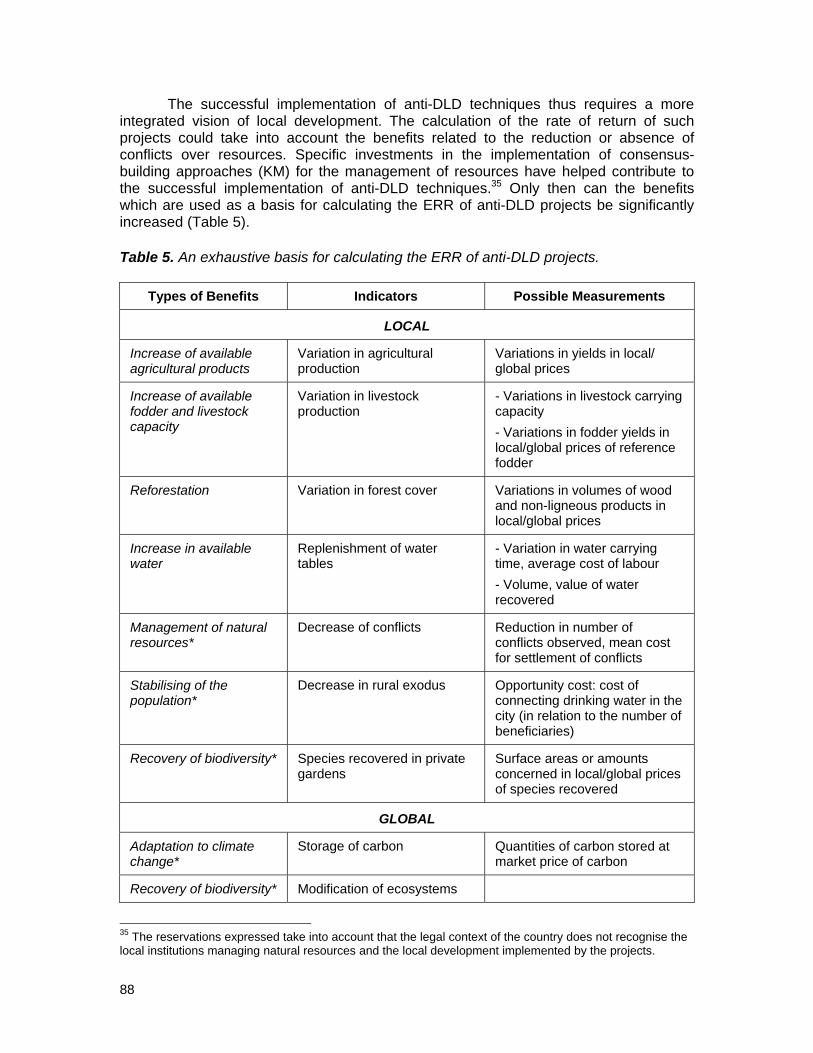
88
The successful implementation of anti-DLD techniques thus requires a more integrated vision of local development. The calculation of the rate of return of such projects could take into account the benefits related to the reduction or absence of conflicts over resources. Specific investments in the implementation of consensus-building approaches (KM) for the management of resources have helped contribute to the successful implementation of anti-DLD techniques.35 Only then can the benefits which are used as a basis for calculating the ERR of anti-DLD projects be significantly increased (Table 5). Table 5. An exhaustive basis for calculating the ERR of anti-DLD projects.
Types of Benefits Indicators Possible Measurements
LOCAL
Increase of available agricultural products
Variation in agricultural production
Variations in yields in local/ global prices
Increase of available fodder and livestock capacity
Variation in livestock production
- Variations in livestock carrying capacity - Variations in fodder yields in local/global prices of reference fodder
Reforestation Variation in forest cover Variations in volumes of wood and non-ligneous products in local/global prices
Increase in available water
Replenishment of water tables
- Variation in water carrying time, average cost of labour - Volume, value of water recovered
Management of natural resources*
Decrease of conflicts Reduction in number of conflicts observed, mean cost for settlement of conflicts
Stabilising of the population*
Decrease in rural exodus Opportunity cost: cost of connecting drinking water in the city (in relation to the number of beneficiaries)
Recovery of biodiversity* Species recovered in private gardens
Surface areas or amounts concerned in local/global prices of species recovered
GLOBAL
Adaptation to climate change*
Storage of carbon Quantities of carbon stored at market price of carbon
Recovery of biodiversity* Modification of ecosystems
35 The reservations expressed take into account that the legal context of the country does not recognise the local institutions managing natural resources and the local development implemented by the projects.

89
and landscapes
Recovery of soil fertility* Variation of vegetation: better water infiltration, increase in fertility. Decrease in albedo
* Indicates benefits which have rarely been quantified to date by anti-DLD projects. Generally speaking, the social and environmental benefits are never or hardly ever taken into account when calculating the figures for projects. However, it appears to be fairly easy to determine three types of benefits, including:
• reducing the number of conflicts over natural resources; • storing carbon once the average rates of storage are known; • stabilising populations even though the opportunity costs method may be
criticised.36 While investments in the fight against DLD produce effects which are objectively advantageous for societies and for the environment, that fact that rural populations in the regions affected do not invest more spontaneously and systematically requires a deeper understanding of the driving factors at the household level. It is possible that the delay in return on anti-DLD investments can be too long given the low financial margins of most of the local producers, and that the social and opportunity costs for implementing such techniques are too high. Research often lacks information on these social and opportunity costs. Filling in these gaps in knowledge could help to understand why the adoption of soil and water conservation practices remains low, and may help to design improved local actions. 3.7. Recommendations and Conclusions This chapter focused on the economics of DLD, the potential applications of environmental valuation techniques and other instruments to address issues related to SLM. It explains the need for economic valuation in decision-making processes and touches upon the causes and effects of the undervaluation of land-based ecosystem services with an argument that information on the economic value of DLD is a prerequisite for M&A. Identifying and evaluating potential economic instruments in the assessment of DLD is important to encourage the sustainable use of land resources. However, one has to be careful with the implementation of incentives and mechanisms. The question of which one is effective, economically reasonable and efficient may depend upon different national, regional and social conditions. Typical criteria for evaluating instruments which should be included are: efficiency, environmental quality improvement, information availability, actual or perceived transaction costs, practicality, time lag, etc. Furthermore, different types of incentives have sometimes quite different time horizons in terms of their effectiveness.
A main cause of the lack of land-related non-market benefits is the omission of exclusive property rights. Institutions and property rights are important as their absence contributes to market or resource management failures and raises the costs of
36 According to the French media during the International Year of Deserts and Desertification (2006), civil society of Northern countries would classify the importance of impacts of the fight against desertification firstly by themes related to climate change and secondly to migration.

90
externalities. National policies to combat DLD often do not take into account externalities; for example, greenhouse effects and shared social costs extend across regional and national boundaries, and therefore funding models need to be driven by international agreements. International organizations, such as the World Bank, UN, Regional Banks, or private organizations, such as the Fulbright or Gates Foundation, are probably the obvious choices to cover many of the costs of M&A on a long-term basis.
The multifaceted complexity of the DLD process necessitates a better understanding of mechanisms of assessment that extend beyond satellite sensor technology. While DLD and its effects are often detected over extended areas at sub-continental scales through the use of space technology, the full effects are primarily the product of land user decisions at a very local scale. Hence, regional and national development plans, including the funding procedures for M&A, are best managed and implemented under international agreements which place emphasis on grassroots participation. Poor farmers with no access to credit are unlikely to share the social costs of DLD in pecuniary terms, but they can help a lot if they learn how to manage their resources more efficiently.
Finally, problems of land tenure and land access need to be addressed (c.f. case study made in 2004-2005 by OSS and the Global Mechanism supported by GEF related to land tenure in “North Africa and Africa Review Report on Drought and Desertification”, Economic Commission for Africa, 2008, pp.6). It must be clarified to whom incentives are directed before designing the appropriate policy instruments.

91
References
Abel, N.O.J., 1993. “Reducing Cattle Numbers on Southern African Communal Range: Is It Worth It?” in Behnke RH, Scoones I, Kerven C (Eds.), Range ecology at disequilibrium: new models of natural variability and pastoral adaptation in African savannas. Overseas Development Institute, London.
Abel, N.O.J. and P.M. Blaikie, 1989. “Land degradation, stocking rates and conservation policies in the communal rangelands of Botswana and Zimbabwe” in Land Degradation & Rehabilitation 1, pp.101-123.
Acheson, J.M., 2006. “Institutional failure in resource management” In Annual Review of Anthropology 35: 117-134.
Adhikari, B. and Lovett, J., 2005. “Transaction Costs and Community-based Natural Resource Management in Nepal” in Journal of Environmental Management 78(1): 5-15.
Akhtar, M. and R.V. Schutzbar, 1994. Ecolgocial and Anthropogenic Restrictions for Animal Husbandry in Animal Research and Development. Vol. 39, Institute for Scientific Co-operation, Tuebingen, Federal Republic of Germany, pp.147-156.
Adeel, Z., J. Bogardi, C. Braeuel, P. Chasek, M. Niamir-Fuller, D. Gabriels, C. King, F. Knabe, A. Kowsar, B. Salem, T. Schaaf, G. Shepherd and R. Thomas, 2006. Overcoming One of the Greatest Environmental Challenges of Our Times: Re-thinking Policies to Cope with Desertification. United Nations University International Network on Water, Environment and Health (UNU-INWEH), Ontario, Canada.
Antle, J.M. and G. Uehara, 2002. “Creating incentives for sustainable agriculture: defining, estimating potential and verifying compliance with carbon contracts for soil carbon projects in developing countries” in A Soil Carbon Accounting System for Emissions Trading – Special Publication, Soil Management Collaborative Research Support Program. University of Hawaii, Honolulu, HI, pp.1-12.
Attwell, C.A.M. and Cotterill, F.P.D., 2000. “Postmodernism and African conservation science” in Biodiversity and Conservation 9: 559-577.
Bai, Z.G., D.L. Dent, L. Olsson and M.E. Schaepman, 2008. Global assessment of land degradation and improvement. 1. Identification by remote sensing. Report 2008/01, ISRIC – World Soil Information, Wageningen.
Bailly D., B. Laplante, V. Cistulli, M. Antona (Eds.), 2000. Etudes de cas en économie d l’environnement. Programme Régional Environnement, COI/EU, 118p. Available at: www.coi-info.org/docscoi/f000163.pdf.
Baland, J.M. and J.P. Platteau, 1996. Halting degradation of natural resources: Is there a role for rural communities? FAO & Clarendon Press, Oxford.
Baker, L.M. and Mutitjulu Community, 1992. Comparing two views of the landscape: Aboriginal traditional ecological knowledge and modern scientific knowledge. Rangel. J.14(2): 174-189.
Barbier, E.B., M. Acreman, D. Knowler, 1997. Evaluation économique des zones humides. Guide à l’usage des planificateurs. Bureau de la Convention de Ramsar, Gland, Switzerland, 155p.
Batagoda, B.M.S., B.R.L. Perera and J.M.D.D.J. De Alwis, 2004. Environmental Treaties Reference Centre (ETRC): A new strategy for centralized information management on (MEAs) in developing countries. Paper presented at the IDDRI International Environmental Governance Conference, Paris, 15-16 March 2004. Available at: http://www.iddri.org/Activites/Conferences/3c_perera.pdf.

92
Bateman, I. and R.K. Turner, 1993. “Valuation of the environment, methods and techniques: the contingent valuation methods” in Turner, R.K. (Ed.) Sustainable environmental economics and management, principles and practices. Belhaven Press, pp.120-191.
Bauer, S. and L.C. Stringer, 2008. Science and policy in the global governance of desertification: an analysis of institutional interplay under the United Nations Convention to Combat Desertification. Global Governance Working Paper No. 35, February. Amsterdam et al.: The Global Governance Project. Available at: www.glogov.org.
Bauer, S. and L.C. Stringer, in press. “The Role of Science in the Global Governance of Desertification” in The Journal of Environment and Development.
Bellal N., 2007. “Rapport final sur l’intégration de l’approche participative dans le projet SMAP" in Bellavite D., O. Belkheiri, G. Enne, H. Saidi, C. Zucca (Eds.) Etudes techniques et scientifiques à l’appui de l’implémentation du projet démonstratif SMAP de Lutte Contre la Désertification. NRD, Université des Etudes de Sassari, Italie.
Betsill, M.M., and E. Corell, 2001. “NGO Influence in International Environmental Negotiations: A Framework for Analysis” in Global Environmental Politics 1(4): 65-85.
Betsill, M.M. and E. Corell, 2008. “NGO Diplomacy: The Influence of Nongovernmental Organizations” in International Environmental Negotiations. Cambridge, MA: MIT Press.
Biot, Y., 1993. “How long can high stocking densities be sustained?” in Behnke R.H., I. Scoones, C. Kerven (Eds.) Range Ecology at Disequilibrium: New Models of Natural Variability and Pastoral Adaptation in African Savannas. Overseas Development Institute, London.
Bishop, R., 1982. “Option value: an exposition and extension” in Land Economic 58:1-5. Blackmore, C., 2007. “What kinds of knowledge, knowing and learning are required for
addressing resource dilemmas? A theoretical overview” in Environmental Science & Policy 10: 512–525.
Boyd, C. and T. Slaymaker, 2000. “Re‐examining the ‘more people less erosion’ hypothesis: special case or wider trend?” ODI Natural Resource Perspectives 63: 1‐6.
Brismar, A., G. Björklund, P. Klintenberg, C. Christiansson, 2004. Methods for assessing the impacts and costs of land degradation and the net benefits of counter-measures. Paper commissioned by the World Bank, 65p.
Brunckhorst, D.J., I. Reeve, P. Morley and K. Bock, 2008. “Strategic spatial governance: deriving social-ecological frameworks for managing landscapes and regions” in Pettit, C., W. Cartwright, I. Bishop, K. Lowell, D. Pullar and D. Duncan (Eds.), Landscape Analysis and Visualisation: Spatial models for natural resource management and planning. Lecture Notes in Geoinformation and Cartography (LNG&C). Springer-Verlag, Berlin.
Campbell, B.M., A. Mandondo, N. Nemarundwe, B. Sithole, W. De Jong, M. Luckert, F. Matose, 2001. "Challenges to proponents of Common Property Resource systems: Despairing voices from the social forests of Zimbabwe” in World Development 29: 589-600.
Carden, F., 2009. Knowledge to policy. IDRC, Canada. Available at: www.idrc.ca/openboooks/417-8.
Carl Bro 1982. An Evaluation of Livestock Management and Production in Botswana with Special Reference to the Communal Areas. Vols. I, II and III. Evaluation Unit. Ministry of Agriculture and the Commission of the European Communities European Development Fund, Malervangen.

93
CBD, UNFCCC and UNCCD, 2005. CBD-UNFCCC-UNCCD Interoperability: Functional Specifications (Revised Draft). Available at: http://www.cbd.int/doc/guidelines/chm-rio-interop-v090-2005-09-en.doc [accessed 21 April 2009].
Central Statistics Office, 2004. Botswana Literacy Survey 2003 [Online]. [Accessed 29/12/04]. Available at: www.cso.gov.bw/html/liter_survey.htm.
Chakeredza, S., A.B. Temu, A. Yaya, S. Mukingwa and J.D.K. Saka, 2009. Mainstreaming Climate Change into Agricultural Education: Challenges and Perspectives. ICRAF Working Paper no. 82. Nairobi, Kenya: World Agroforestry Centre. Available at: http://www.worldagroforestry.org/downloads/publications/PDFs/WP15993.PDF.
Chasek, P. S., 2009. Mind the Gap: Confronting the MEA Implementation Gap in the Pacific Island Countries. Paper submitted to the International Studies Association 50th Convention New York, NY, 15-18 February 2009.
Chasek, P. and E. Corell, 2002. “Addressing Desertification at the International Level: The Institutional System,” in James Reynolds and Mark Stafford Smith, eds. Global Desertification: Do Humans Cause Deserts? Berlin: Dahlem University Press.
Ciracy-Wantrup, S.V. and R.C. Bishop, 1975. “Common Property as a Concept in Natural Resource Policy” in Natural Resource Journal 15: 713-727.
Clough, P., 2000. Encouraging Private Biodiversity - Incentives for Biodiversity Conservation on Private Land. Treasury Working Paper Series 00/25, New Zealand Treasury.
Coase, R., 1993. “The problem of social cost” in Dorfman, R. and N.S. Dorfman (Eds.), Economics of the Environment. Norton & Company, Inc., pp.109-138.
Collins, H. M. and R. Evans, 2002. “The third wave of science studies” in Social Studies of Science, 32(2): 235-296
Cooke, B. and U. Kothari (Eds.), 2001. Participation: the New Tyranny? Zed Books, London.
Cooke, H.J., 1985. “The Kalahari today: A case of conflict over resource use” In The Geographical Journal 151(1): 75-85.
Cowie, A., S. Uwe and L. Montanarella, 2007. “Potential Synergies between Existing Multilateral Environmental Agreements in the Implementation of Land Use, Land-use Change and Forestry Activities” in Environmental Science and Policy 10: 335-352.
Coxhead, I. and S. Jayasuriya, 1994. “Technical change in agriculture and land degradation in developing countries: a general equilibrium analysis” in Land Economics 70(1): 20-37.
Dahlberg, A.C. 2000. “Interpretations of environmental change and diversity: A critical approach to indications of degradation - The case of Kalakamate, northeast Botswana” in Land Degradation & Development 11: 549-562.
Davis, D.K., 2005. “Indigenous knowledge and the desertification debate: problematising expert knowledge in North Africa” in Geoforum 36: 509-524.
Davies C, M. Wetherell, E. Barnett, 2006. Citizens at the Centre: Deliberative Participation in Health Care Decisions. Bristol: Policy Press.
Dean, W.R.J. and I.A.W. Macdonald, 1994. “Historical changes in stocking rates of domestic livestock as a measure of semiarid and arid rangeland degradation in the Cape-Province, South-Africa” in Journal of Arid Environments 26: 281-298.
DFID/EC/UNDP/World Bank, 2002. Linking poverty reduction and environmental management: Policy challenges and opportunities.
Dirk, E., C. Hager, M. Tadross, S. Bethune and B. Curtis, 2008. Climate change vulnerability and adaptation assessment, Namibia. Ministry of Environment and Tourism, Windhoek. 167pp.

94
DIVERSITAS, 2008. About Diversitas. Available at: http://www.diversitas-international.org.
DIVERSITAS, 2009. Regional Committees. Available at: http://www.diversitas-international.org/?page=regional.
Dougill, A.J., D.S.G. Thomas and A.L. Heathwaite, 1999. “Environmental Change in the Kalahari: Integrated Land Degradation Studies for Non-equilibrium Dryland Environments” in Annals of the Association of American Geographers 89: 420-442.
Dougill, A.J. and M.S. Reed, 2006. “Framework for community-based rangeland sustainability assessment in the Kalahari, Botswana” in Hill, J., W. Woodland, A. Hill (Eds.), Sustainable Development: National Aspirations, Local Implementation Ashgate Publishing, pp.31-49. Available at: http://homepages.see.leeds.ac.uk/~lecmsr/DougillandReedreviseddec05.doc.
Dougill, A.J., E.D.G. Fraser and M.S. Reed, (under review). “Anticipating vulnerability in food systems to climate variability and change: challenges of using dynamic systems approaches and the case of pastoral systems in Botswana” in Ecology & Society.
Dregne, H., 1991. Desertification Costs: Land Damage and Rehabilitation. Consultant's Report prepared for UNEP and International Centre for Arid and Semi-arid Land Studies (ICASALS). Nairobi.
Dregne, H. and Nan‐Ting Chou, 1992. “Global desertification dimensions and costs” in H. Dregne (Ed.) Degradation and restoration of arid lands, Texas Tech University, Lubbock, pp. 249‐282.
Dretske, F., 1981. Knowledge and the Flow of Information. MIT Press, Cambridge, MA.
Duariappah, A.K. and P. Roddy, 2005. Integrating the environment into the poverty reduction strategy papers: a methodology for evaluating a country’s perception of its performance. IISD.
Enne G., D. Peter, C. Zanolla and C. Zucca (Eds), 2004. The MEDRAP Concerted Action to support the Northern Mediterranean Action Programme to Combat Desertification. Milano, pp 938.
Esler, K.J., Milton, S.J., Dean, W.R.J., 2005. Karoo Veld: Ecology and Management. Briza Publications, Pretoria.
Esty, Daniel C., A. Jack, Ted Goldstone, R. Gurr, Barbara Harff, Marc A. Levy, Geoffrey D. Dabelko, Pamela T. Surko and Alan N. Unger (Eds.), 1998. State Failure Task Report: Phase II Findings. McLean, VA: Science Applications International Corporation.
Failing, L., R. Gregory and M. Harstone, 2007. “Integrating science and local knowledge in environmental decisions: a decision-focused approach” in Ecological Economics 64: 47-60.
Faucheux, S. and J.F. Noël, 1996. Economie des ressources naturelles et de l’environnement. Armand Colin, 370p.
Fazey, I., J. Fazey, J. Fischer, K. Sherren, J .Warren, N. Reed, and S. Dovers, 2007. “Adaptive capacity and learning to learn as leverage for social-ecological resilience” in Frontiers in Ecology and the Environment 5: 375-380.
Fazey, I., J.A. Fazey, J.G. Salisbury, D.B. Lindenmayer, and S. Dovers, 2006a. “The nature and role of experiential knowledge for environmental conservation” in Environmental Conservation 33: 1-10.
Fazey, I., K. Proust, B. Newell, B. Johnson, and J.A. Fazey, 2006b. "Eliciting the implicit knowledge and perceptions of on-ground conservation managers of the Macquarie Marshes” in Ecology and Society 11: Art 25.
Fazey, J.A. and F. Marton, 2002. “Understanding the space of experiential variation” in Active Learning in Higher Education 3: 234-250.

95
Ferrarini, A., A. Bodini and M. Becchi, 2001. “Environmental quality and sustainability in the province of Reggio Emilia (Italy): using multi-criteria analysis to assess and compare municipal performance” in Journal of Environmental Management 63: 117–131.
Finus, M., 2000. Game theory and international environment co-operation: A survey with an application to the Kyoto Protocol. Working paper, FEEM, Nota di Lavoro, pp. 86.
Fraser, E.D.G., A.J. Dougill, W. Mabee, M.S. Reed and P. McAlpine, 2006. “Bottom up and top down: Analysis of participatory processes for sustainability indicator identification as a pathway to community empowerment and sustainable environmental management” in Journal of Environmental Management 78: 114-127.
Fraser, E.D.G., C.H. Quinn, A.J. Dougill, M. Termansen and M.S. Reed (under review). “Assessing the Vulnerability of Dry-Land Livelihood Systems to Climate Change using Historic Narratives and Mathematical Models” in Ecology & Society.
Frederick, S., G. Loewenstein and T. O'Donoghue, 2002. “Time Discounting and Time Preference: A Critical Review” in Journal of Economic Literature 40(2): 351-401.
Giller, K.E., E.C. Rowe, N. de Ridder and H. van Keulen, 2006. “Resource use dynamics and interactions in the tropics: Scaling up in space and time” in Agricultural Systems 88: 8‐27.
Glenn, E., M. Stafford Smith and V. Squires, 1998. “On our failure to control desertification: implications for global change issues, and a research agenda for the future” In Environmental Science and Policy 1: 71-78.
Global Mechanism, 2002. The Global Mechanism partnership with Tunisia in the context of the implementation of the National Action Programme to Combat Desertification: What are the lessons learned? Global Mechanism/IFAD, Italy.
Global Mechanism, 2007. Cashing in on the links between climate change and land degradation; the Global Mechanism’s strategic programme on climate change and compensation for environmental services. Global Mechanism, Rome, Italy, p.18.
Global Mechanism, 2009. North Africa programme. Available at: http://www.global-mechanism.org/about-s/regionalprogrammes/na.
Gooberman-Hill, R., J. Horwood, M. Calnan, 2008. “Citizens’ juries in planning research priorities: process, engagement and outcome” in Health Expectations 11: 272–281.
GRM 1986. Re-Establishment of a National Range Resource Assessment and Monitoring Programme. Draft Final Report. GRM International Pty. Ltd., Ministry of Agriculture. Gaborone.
Gunderson, L. and C.S. Holling, 2002. Panarchy: understanding transformations in human and natural systems. Island Press, Washington.
Gupta, A. (Ed.), 1989. Honey Bee, a quarterly newsletter. Indian Institute of Management, Ahmedabad, India.
Haas, Peter M., Marc A. Levy and Robert O. Keohane (Eds.), 1993. Institutions for the Earth: Sources of Effective International Environmental Protection. Cambridge, MA: Harvard University Press.
Hajjej, M.S. and N. Ben Khatra, 2006. “Link between the NAP/CD monitoring-evaluation mechanism and the development process in Tunisia”. The monitoring and evaluation of National Action Programmes to Combat Desertification. Observatoire du Sahara et du Sahel (OSS). Tunisia.
Hardin, G.J., 1968. “The Tragedy of Commons” in Science 162: 1243-1248. Hanna, S., 1998. “Managing for human and ecological context in the Maine soft shell
clam fishery” in F. Berkes and C. Folke (Eds.), Linking social and ecological systems: management practices and social mechanisms for building resilience. Cambridge University Press, Cambridge, UK, pp. 190-211.

96
Herrera-Ulloa, A.F., A.T. Charles, S.E. Lluch-Cota, H. Ramirez-Aguirre, S. Hernandez-Vazquez, A.F. Ortega-Rubio, 2003. A regional-scale sustainable development index: the case of Baja California Sur, Mexico International Journal of Sustainable Development and World Ecology 10: 353-360.
Holland, J. and J. Campbell (Eds.), 2005. Methods, Knowledge and Power: Combining qualitative and quantitative development research, ITDG Publications.
Howells, J., 2006. “Intermediation and the role of intermediaries in innovation” in Research Policy 35: 715-728.
ICESDP, 2008. Report from the International Commission on Education for Sustainable Development Practice. Columbia University Earth Institute, New York. Available at: http://www.wfeo.org/documents/download/ICESDP%20Final%20Report%202008.pdf
Illius, A.W. and T.G. O’Connor, 1999. “On the relevance of non-equilibrium concepts to arid and semiarid grazing systems” in Ecological Applications 9: 798-813.
Imeson, A., A. Arnoldussen, D. de la Rosa, L. Montanarella, L. Dorren, M. Curfs, O. Arnalds and S. van Asselen (Eds.), 2006. SCAPE Soil Conservation and Protection in Europe. Heiloo, Netherlands, Drukkerij Uitkijkpost bv.
IPCC, 2007. Future of the IPCC. IPCC-XXVII/INF. 3. Available at: http://www.ipcc.ch/meetings/session27/inf3.pdf.
ISRIC (International Soil and Reference Information Centre), 2003. Global Assessment of Human-Induced Soil Degradation [Online]. Available at: http://lime.isric.nl/index.cfm?contentid=158. [Accessed 29/12/04].
Italian Association of NGOs, 2006. The Role of Civil Society in Implementation of the UNCCD. Paper presented at the Workshop on Combating desertification and poverty in drylands: Promoting decentralized cooperation and the participation of civil society in implementation of the UNCCD, Rome, Italy, 19-20 January. Available at: http://www.unccd.int/workshop/rome2006/docs/item1-eng.pdf.
IUCN, TNC and the World Bank, 2004. How Much is an Ecosystem Worth? Assessing the Economic Value of Conservation. IUCN/TNC/World Bank, IBRD/The World Bank, Washington, D.C.
Johnson, P.M., K. Mayrand and M. Paquin, 2006. Governing global desertification: Linking environmental degradation, poverty and participation. Ashgate Publishing, UK.
Joint Liaison Group, 2007. Adaptation Under the Frameworks of the CBD, the UNCCD and the UNFCCC. Bonn: CBD, UNCCD, UNFCCC. Available at: http://www.unccd.int/publicinfo/factsheets/pdf/adaptation_eng.pdf.
Jones, J.W., W.D. Graham, D. Wallach, W.M. Bostick and J. Koo, 2004. “Estimating soil carbon levels using an ensemble Kalman filter” in Transactions of the ASAE 47: 331-339.
Kambatuku, J., 2003. Local level monitoring for enhanced decision making. Napcod & SDDI, Windhoek, 21 pp.
Katz, E.G., 2000. “Social capital and natural capital: a comparative analysis of land tenure and natural resource management in Guatemala” in Land Economics 76: 114-132.
Keeley, J. and I. Scoones, 2003. Understanding Environmental Policy Processes: Cases from Africa. Earthscan, London.
Keohane, Robert O., and Marc A. Levy, 1996. Institutions for Environmental Aid: Pitfalls and Promise. MIT Press, Cambridge, MA.
Kipuri, N., 1996. “Pastoral Maasai grassroots indicators for sustainable resource management” in Hambly, H. and T. O. Angura (Eds.), Grassroots indicators for desertification experience and perspectives from Eastern and Southern Africa. International Development Research Centre, Ottawa, Ontario, Canada, pp. 110-119.

97
Kirkby, M.J., R.J.A. Jones, B. Irvine, A. Gobin, G. Govers, O. Cerdan, A.J.J. van Rompaey, Y. Le Bissonnais, J. Daroussin, D. King, L. Montanarella, M. Grimm, V. Vieillefont, J. Puigdefabregas, M. Boer, C. Kosmas, N. Yassoglou, M. Tsara, S. Mantel and G. van Lynden, 2004. Pan-European Soil Erosion Risk Assessment: The PESERA Map, Version 1. Office for Official Publications of the European Communities, Luxembourg.
Kirkby, M.J., Irvine, B.J., Jones, R.J.A., Govers, G., the PESERA team, 2008. “The PESERA coarse scale erosion model for Europe: I – Model rationale and implementation” in European Journal of Soil Science 59: 1293-1306.
Klerkx, Hall and Leeuwis, 2009. Strengthening Agricultural Innovation Capacity: Are Innovation Brokers the Answer? UNU-MERIT, Maastricht, the Netherlands.
Klintenberg, P., G. Gustad, A.S. Kruger and M.K. Seely, 2003. “Monitoring desertification in Namibia: A tool for improved natural resource management” in N. Allsopp et al. (Eds.), VIIth International Rangelands Congress, Durban, South Africa, pp. 717-719.
Klintenberg, P., A.S. Kruger and M.K. Seely, 2008. “Local level monitoring for improved farming management” in Nhira, C., A. Mapiki and P. Rankhumise (Eds.), Land and Water Management in Southern Africa: Towards sustainable agriculture. The Africa Institute of South Africa, Pretoria, South Africa, pp. 463-473.
Klintenberg, P and M. Seely, 2004. “Land degradation monitoring in Namibia: a first approximation” in Environmental Monitoring and Assessment 99(1-3): 5-21.
Klintenberg, P and A. Verlinden, 2008. “Water points and their influence on grazing resources in central northern Namibia” in Land Degradation & Development 19: 1-20.
Kloppenburg, J.R., 1991. “Social theory and the de/reconstruction of agricultural science: Local knowledge for an alternative agriculture” in Rural Sociology 56(4): 519-548.
Knabe, F., 2006. “Civil society’s role in negotiating and implementing the UNCCD” in Johnson, P.M., K. Mayrand and M. Paquin (Eds.), Governing global desertification: Linking environmental degradation, poverty and participation. Ashgate Publishing, UK, pp. 89-107.
Kosmas, C., M. Kirkby and N. Geeson, 1999. The MEDALUS Project, Mediterranean Desertification and Land Use: Manual on key indicators of desertification and mapping environmentally sensitive areas to desertification. Office for official publications of the European Communities, Luxembourg. EUR 18882.
Kosmas, C., M. Tsara, N. Moustakas and Ch. Karavitis, 2003. “Land desertification and identification indicators” in Annals in Arid Zones, pp. 393-416.
Kosmas, C., M. Tsara, N. Moustakas, D. Kosma and N. Yassoglou, 2006. “Environmentally sensitive areas and indicators of desertification” in Kepner, W., J.L. Rubio, D.A. Mouat, F. Pedrazzini (Eds.), Desertification in the Mediterranean Region: a Security Issue. Springer, pp. 527-547.
Kroll, T. and A.S. Kruger, 1998. “Closing the gap: bringing communal farmers and service institutions together for livestock and rangeland development” in Journal of Arid Environments 39: 315-323.
Krug, C.B., K.J. Esler, M.T. Hoffman, J. Henschel, U. Schmiedel and N. Jürgens, 2006. “North/South cooperation through BIOTA: An interdisciplinary monitoring programme in arid and semi-arid southern Africa” in South African Journal of Science 102: 187-190.
Kruger, A.S., P. Klintenberg and M.K. Seely, 2008. “Forum for integrated resource management in Namibia” in Nhira, C., A. Mapiki and P. Rankhumise (Eds.), Land and Water Management in Southern Africa: Towards sustainable agriculture. The Africa Institute of South Africa, Pretoria, South Africa, pp. 290-295.
Landell-Mills, N., and I. Porras, 2002. Silver bullet or fool’s gold? A global review of markets for forest environmental services and their impact on the poor. Instruments

98
for Sustainable Private Sector Forestry Series, London, UK: International Institute for Environment and Development.
Larson B.A. and D.W. Bromley, 1990. “Property Rights, Externalities, and Resource Degradation. Locating the Tragedy” in Journal of Development Economics 33: 235-262.
Lepers, E., 2003. Synthesis of the main areas of land‐cover and land‐use change. Millennium Ecosystem Assessment, Final Report.
Lescuyer, G., 2000. Evaluation économique et gestion visable de la forêt tropicale. Réflexion sur un mode de coordination des usages d’une forêt de l’est-Cameroun. Thèse en socio-économie. Ecole des Hautes Etudes en Sciences Sociales, Paris 417p.
Liniger, H.P. and G. Schwilch, 2002. “Enhanced Decision-Making Based on Local Knowledge - WOCAT Method of Sustainable Soil and Water Management” in Mountain Research and Development 22(1): 14-18.
Long Martello, M., 2004. “Expert Advice and Desertification Policy: Past Experience and Current Challenges” in Global Environmental Politics 4(3): 85-106.
López‐Ridaura, S., H. van Keulen and K.E. Giller, 2007. “Designing and evaluating alternatives for more sustainable natural resource management in less‐favoured areas” in Ruben, R., J. Pender and A. Kuyvenhoven (Eds.), Sustainable poverty reduction in less‐favoured areas. CABI, UK, pp. 65‐90.
Lundvall, B.A. and B. Johnson, 1994. “The learning economy” in Journal of Industry Studies 1: 23-42.
Lynam, T.J.P. and M. Stafford-Smith, 2004. “Monitoring in a complex world – seeking slow variables, a scaled focus and speedier learning” in African journal of Range & Forage Science 21(2): 69-78.
Mackinson, S. and L. Nottestad, 1998. “Combining local and scientific knowledge” in Reviews in Fish Biology and Fisheries 8: 481-490.
McGowan International and Coopers Lybrand 1988. National Land Management and Livestock Project: Incentives/Disincentives Study. Vols. I, II and III. Gaborone. Botswana.
Millennium Development Goals, 2000. Available at: http://www.un.org/millenniumgoals/bkgd.shtml.
Millennium Ecosystem Assessment, 2005. Ecosystems and Human Well-being Synthesis. Island Press, Washington D.C.
Mouat, D., J. Lancaster, I. El-Bagouri and F. Santibaňez (Eds.), 2006. Opportunities for synergy among the environmental conventions: results of national and local level workshops. UNCCD, Bonn, Germany.
Mphinyane, W.N, G.N. Smit and N.F.G. Rethman, 2008. “Influence of livestock grazing on the woody component within piospheres of semi-arid savanna in central Botswana” in Botswana Journal of Agricultural Applied Science 4(1): 4-15.
Myers, E.C., 2007. Emissions from Deforestation and Degradation (REDD) in Tropical Forests: An Examination of the Issues Facing the Incorporation of REDD into Market-based Climate Policies. RFF Discussion Paper, RFF DP 07-50, Resource for the Future, Washington, D.C.
Niamir, M., 1991. Traditional African Range Management Techniques: Implications for Rangeland Development. Pastoral Development Network Paper 31d, Overseas Development Institute, London.
Najam, A., M. Papa and N. Taiyab, 2006. Global Environmental Governance: A Reform Agenda. Winnipeg: International Institute for Sustainable Development.

99
Ng, M.K. and P. Hills, 2003. “World cities or great cities? A comparative study of five Asian metropolises” in Cities 20: 151-165.
Ngugi, M.K. and R.T. Conant, 2008. “Ecological and social characterization of key resource areas in Kenyan rangelands” in Journal of Arid Environments 72: 820-835.
Niamir-Fuller, M., 1998. “The resilience of pastoral herding in Sahelian Africa” in Berkes, F. and C. Folke (Eds.), Linking social and ecological systems: management practices and social mechanisms for building resilience. Cambridge University Press, Cambridge, UK, pp. 250-284.
Niemeijer, D. et al., 2009. Strengthening GEF SLM project designs through impact pathways. Report of the KM:Land Initiative, GEF in press.
Nowotny, H., 2003. “Dilemma of expertise: democratizing expertise and socially robust knowledge” in Science and Public Policy 30: 151-156.
Oba, G. and L.M. Kaitira, 2006. “Herder knowledge of landscape assessments in arid rangelands in northern Tanzania” in Journal of Arid Environments 66: 168-186.
Oba, G., N.C. Stenseth, W.J. Lusigi, 2000. “New perspectives on sustainable grazing management in arid zones of sub-Saharan Africa” in Bioscience 50: 35-51.
OECD, 1993. OECD Core Set of Indicators for Environmental Performance Reviews. A Synthesis Report by the Group on the State of the Environment. Organisation for Economic Co-operation and Development, Paris.
OECD, 2001. Environmental Indicators for Agriculture: Methods and Results, Vol. 3. OECD, Paris, France.
Oldeman, L.R., R.T.A. Hakkeling and W.G. Sombroek, 1991. World map of the status of human‐induced soil degradation: an explanatory note. Second Edition. Wageningen, The Netherlands and Nairobi, Kenya: International Soil Reference and Information Centre/United Nations Environment Programme.
OSS, 2006. The monitoring and evaluation of National Action Programmes to Combat Desertification. Observatoire du Sahara et du Sahel (OSS). Tunisia.
Ostrom, E., 1990. Governing the Commons: The evolution of institutions for collective action. Cambridge University Press, Cambridge.
Ostrom, E., 2000. “Private and common property rights” in Bouckaert B. and G. De Geest (Eds.), Encyclopaedia of law and economics. Edward Elgar Publishing, Cheltenham, pp. 332-379.
Pahl-Wostl, C., M. Hare, 2004. “Processes of Social Learning in Integrated Resources Management” in Journal of Community & Applied Social Psychology 14:193-206.
Pagiola, S., P. Agostini, G. Gobbi, G. de Haan, M. Ibrahim, E. Murgueitio, E. Ramirez, M. Rosales and J.P. Ruiz, 2004. Paying for biodiversity conservation services in agricultural landscapes. Environment Department Paper no. 96. World Bank, Washington, D.C.
Pagiola, S., P. Agostini, G. Gobbi, G. de Haan, M. Ibrahim, E. Murgueitio, E. Ramirez, M. Rosales, J.P. Ruiz, 2004. Paying for biodiversity conservation services in agricultural landscapes. Environment Department Paper No. 96, World Bank, Washington, D.C.
Pagiola, S., N. Landell-Mills and J. Bishop, 2002. “Making market-based mechanisms work for forests and people” in Pagiola, S., J. Bishop and N. Landell-Mills (Eds.) Selling Forest Environmental Services: Market-based Mechanisms for Conservation and Development. Earthscan, London.
Pagiola, S., K. von Ritter, J. Bishop, 2004. Assessing the Economic Value of Ecosystem Conservation. World Bank Environment Department Paper, 58 p.
Panayotou, T., 1994. Economic Instruments for Environmental Management and Sustainable Development. Paper prepared for the UNEP’s Consultative Expert Group Meeting on the Use and Application of Economic Policy Instruments for

100
Environmental Management & Sustainable Development, Nairobi, 23-24 February, 1995. Environmental Economics Series, Paper No. 16.
Pearce, R., 2006. “Decentralisation and Sustainable Resources Management in West Africa: A Line of Action for Revisiting National Action Programmes” in Johnson, P.M., K. Mayrand and M. Paquin (Eds.), Governing Global Desertification: Linking Environmental Degradation, Poverty and Participation. Burlington, VT: Ashgate.
Perrings, C. and D.L. Stern, 2000. “Modelling loss of resilience in agro ecosystems: Rangelands in Botswana” in Environmental and Resource Economics 15: 243-256.
Phillipson, J. and A. Liddon, 2007. Common knowledge? An exploration of knowledge transfer. Rural Economy and Land Use Programme Briefing Series No 6. Available at: http://www.relu.ac.uk/news/briefings/RELUBrief6%20Common%20Knowledge.pdf
Pickup, G., G.N. Bastin and V.H. Chewings, 1998. “Identifying trends in land degradation in non-equilibrium rangelands” in Journal of Applied Ecology 35: 365-377.
Platteau, J.P., 2003. Droits de propriété et gestion efficace des ressources naturelles. Idées pour le débat no. 15/2003. Iddri, 40p.
Prell, C., K. Hubacek, M.S. Reed, T.P. Burt, J. Holden, N. Jin, C. Quinn, J. Sendzimir and M. Termansen, 2007. “If you have a hammer everything looks like a nail: ‘traditional’ versus participatory model building” in Interdisciplinary Science Reviews 32: 1-20
Pretty, J.N., A.D. Noble, D. Bossio, J. Dixon, R.E. Hine, F.W.T. Penning de Vries and J.I.L. Morison, 2006. “Resource‐conserving agriculture increases yields in developing countries” in Environmental Science & Technology. 40: 1114‐1119.
Quinn, C.H., M. Huby, H. Kiwasila and J.C. Lovett, 2007. “Design principles and common pool resource management: An institutional approach to evaluating community management in semi-arid Tanzania” in Journal of Environmental Management 84: 100-113.
Randall, A., 1987. Resources Economics. An economic approach to Natural Resources and Environmental Policy. John Wiley & Sons, New York.
Raymond, C.M. and G. Brown, 2006. “A method for assessing protected area allocations using a typology of landscape values” in Journal of Environmental Planning and Management 49:797-812.
Raymond, C.M., B.A. Bryan, D. Hatton MacDonald, A. Cast, S. Strathearn, A. Grandgirard and T. Kalivas, 2009. Mapping community values for natural capital and ecosystem services. Ecological Economics 68: 1301-1315.
Reed, M.S. and A.J. Dougill, 2002. “Participatory selection process for indicators of rangeland condition in the Kalahari” in The Geographical Journal 168: 224-234.
Reed, M.S., E.D.G. Fraser and A.J. Dougill, 2006. “An adaptive learning process for developing and applying sustainability indicators with local communities” in Ecological Economics 59: 406-418.
Reed, M.S., 2008. “Stakeholder participation for environmental management: a literature review” in Biological Conservation 141: 2417-2431
Reed, M.S., A.J. Dougill and T. Baker, 2008. “Participatory indicator development: what can ecologists and local communities learn from each other?” in Ecological Applications 18: 1253-1269
Reed M.S., A. Graves, N. Dandy, H. Posthumus, K. Hubacek, J. Morris, C. Prell, C.H. Quinn, L.C. Stringer, 2009. “Who’s in and why? Stakeholder analysis as a prerequisite for sustainable natural resource management” in Journal of Environmental Management 90: 1933-1949.
Reed, M.S., A.J. Dougill (in press). “Linking Degradation Assessment to Sustainable Land Management: a decision support system for Kalahari pastoralists” in Journal of Arid Environments.

101
Reij, C. and A. Waters-Bayer, 2001. Farmer innovation in Africa: A source of inspiration for agricultural development. Earthscan, London, UK.
Reij, C. and D. Steeds, 2003. Success stories in Africa’s drylands: supporting advocates and answering sceptics. Paper commissioned by the Global Mechanism of the Convention to Combat Desertification, 32p.
République Tunisienne, 2003. Evaluation du Coût de la Dégradation de l’Environnement. METAP report, World Bank.
Requier-Desjardins, M. and M. Bied-Charreton, 2006. Evaluation socio-économique des coûts de la désertification. AFD-C3ED report, 162p.
Reynolds, J.F., D.K. Stafford Smith, E.F. Lambin, B.L. Turner II, M. Mortimore, S.P.J. Batterbury, Th.E. Dowing, H. Dowlatabadi, R.J. Fernández, J.E. Herrick, E. Huber Sannwald, H. Jiang, R. Leemans, T. Lynam, F.T. Maestre, M. Ayarza, B. Walker, 2007. "Global desertification: Building a science for dryland development” in Science 316: 847-851.
Safriel, U.N., 2007. “The assessment of global trends in land degradation” in Sivakumar, M.V.K. and N. Ndiang’ui (Eds.) Climate and Land Degradation. Springer Verlag, Berlin-Heidelberg, p.1-38.
Sallu, S.M., C. Twyman, D.S.G. Thomas, 2009. „The multidimensional nature of biodiversity and social dynamics and implications for contemporary rural livelihoods in remote Kalahari settlements, Botswana“ in African Journal of Ecology 47: 110–118.
Saouma, E., 1993. “Indigenous Knowledge and Biodiversity” in Harvesting Nature’s diversity. FAO, Rome.
Sayer, J.A. and B.M. Campbell, 2003. “Research to integrate productivity enhancement, environmental protection, and human development” in Campbell, B.M. and J.A. Sayer (Eds.), Integrated natural resource management: Linking productivity, the environment and development. CABI Publishing, UK. pp. 1-14.
Schmiedel, U., 2006. Capacity development and scientist-land user collaboration towards sustainable management of Communal Lands in southern Africa - creating initial structures. CD publication, Soil and Desertification - Integrated Research for the Sustainable Management of Soils in Drylands, Hamburg, Germany.
Schreurs, Miranda A. and Elizabeth Economy (Eds.), 1997. The Internationalization of Environmental Protection. Cambridge, UK: Cambridge University Press.
Schuster, B., D. Niemeijer, C. King, Z. Adeel, 2009. “The challenge of measuring impacts of sustainable land management – development of a global indicator system” in Proceedings of the International Dryland Development Consortium. Alexandria Egypt 2008 (in press).
Schwilch, G., F. Bachmann and H.P. Liniger, 2009. “Appraising and selecting conservation measures to mitigate desertification and land degradation based on stakeholder participation and global best practices” in Land Degradation and Development (in press).
Scoones, I., 2001. Dynamics and diversity: soil fertility and farming livelihoods in Africa. Earthscan, London, UK.
Seely, M., 1998. “Can science and community action connect to combat desertification?” in Journal of Arid Environments 39(2): 267-277.
Seely, M and P. Klintenberg, 2007. “Can information circulation contribute to combating desertification?” in Enne, G. and M. Yeroyanni (Eds.), AIDCCD - active exchange of experience on indicators and development of perspectives in the context of UNCCD. Centro Interdipartimentale di Ateneo Nucleo Ricerca Desertificazione; Università degli Studi di Sassari, Windhoek and Ondangwa, pp. 13-23.

102
Seely, M., P. Klintenberg and A.S. Kruger, 2006. The dilemma of connecting research and research results with community action (abstract). AAAS Annual Meeting. AAAS, St. Louis, Missouri.
Seely, M., P. Klintenberg and A.S. Kruger, 2008. “The unmet challenge of connecting scientific research with community action” in Lee, C. and T. Schaaf (Eds.), The future of drylands. UNESCO, Tunis, pp. 687-697.
Seely, M. and P. Moser, 2004. “Connecting community action and science to combat desertification: evaluation of a process” in Environmental Monitoring and Assessment, 99(1-3): 33-55.
Shepherd, G., 2008. “An ecosystems approach to natural resource management in the Sahel” in Lee C. and T. Schaaf (Eds.) The Future of Drylands. Proceedings of the International Scientific Conference on Desertification and Drylands Research, Tunis, Tunisia, 19-21 June 2006. UNESCO Springer, pp.619-631.
Sillitoe, P., 1998. “Knowing the land: soil and land resource evaluation and indigenous knowledge” in Soil Use and Management 14: 188-193.
Sivakumar, M.V.K. and N. Ndiang’ui (Eds.), 2007. Climate and Land Degradation. Springer-Verlag, New York. 623p.
South African Department of Environmental Affairs and Tourism, 2004. National Action Programme: Combating Land Degradation to Alleviate Rural Poverty. Available at: http://www.unccd.int/actionprogrammes/africa/national/2004/south_africa-eng.pdf.
Sporton, D. and D.S.G. Thomas, 2002. Sustainable Livelihoods in Kalahari Environments. Oxford University Press, Oxford.
Stern, N.H., 2007. The Economics of Climate Change. The Stern Review, Cambridge University Press, 713p.
Stockholm Convention, 2008. Enhancing cooperation and coordination among the Basel, Rotterdam and Stockholm conventions. UNEP/POPS/COP.4/32. Available at: http://chm.pops.int/Portals/0/Repository/COP4/UNEP-POPS-COP.4-32.English.pdf.
Stringer, L.C., 2008. “Can the UN Convention to Combat Desertification guide sustainable use of the world’s soils?” in Frontiers in Ecology and the Environment 6, doi:10.1890/070060.
Stringer L.C., J.C. Dyer, M.S. Reed, A.J. Dougill, C. Twyman and D. Mkwambisi, 2009. “Adaptations to climate change, drought and desertification: local insights to enhance policy in southern Africa” in Environmental Science and Policy (in press).
Stringer, L.C., and M.S. Reed, 2007. “Land degradation assessment in southern Africa: integrating local and scientific knowledge bases” in Land Degradation and Development 18: 99-116.
Stringer, L.C., M.S. Reed, A.J. Dougill, M.K. Seely and M. Rokitzki, 2007a. “Implementing the UNCCD: Participatory challenges” in Natural Resources Forum 31: 198-211.
Stringer, L.C., C. Twyman and D.S.G. Thomas, 2007b. “Combating land degradation through participatory means: the case of Swaziland” in Ambio 36: 387-393.
Stringer, L. C., C. Twyman and L.M. Gibbs, 2008. “Learning from the South: common challenges and solutions for small-scale farming” in The Geographical Journal 174: 235-250.
Stuart-Hill, G., R. Diggle, B. Munali, J. Tagg, and D. Ward, 2005. “The event book system: a community based natural resource monitoring system for Namibia” in Biodiversity and Conservation 14: 2611-2631.
Tallis, H., P. Kareiva, M. Marvier, A. Chang, 2008. "An ecosystem services framework to support both practical conservation and economic development” in Proceedings of the National Academy of Sciences 105: 9457-9464.

103
TEEB, 2009. The Economics of Ecosystems and Biodiversity, Interim Report. European Communities, Cambridge, UK.
Thomas, D.S.G., D. Sporton and J.S. Perkins, 2000. “The environmental impact of livestock ranches in the Kalahari, Botswana: natural resource use, ecological change and human response in a dynamic dryland system” in Land Degradation and Development 11: 327-341.
Thomas, D.S.G. and C. Twyman, 2004. “Good or bad rangeland? Hybrid knowledge, science, and local understandings of vegetation dynamics in the Kalahari” in Land Degradation and Development 15: 215-231.
Thomas, R.J., 2008. “10th Anniversary review: Addressing land degradation and climate change in dryland agroecosystems through sustainable land management” in Journal of Environmental Monitoring 10: 595-603.
Tlhalerwa, N., 2008. Gendered Indigenous Traditional Knowledge (ITK) System: Towards Sustainable Access and Management of Natural Resources in Khawa Village, Kgalagadi South Sub-District, Botswana. MSc dissertation, Department of Environmental Science, University of Botswana, Gaborone.
Tsimako, B. 1991. The Tribal Grazing Land Policy (TGLP) Ranches: Performance to Date, Ministry of Agriculture, Gaborone.
Twyman, C., A.J. Dougill, D. Sporton and D.S.G. Thomas, 2001. “A case of community self empowerment, Okonyoka, Eastern Namibia: environmental and policy implications” in Review of African Political Economy, 28(87): 9-26.
Tyler, S.R., 2006. Communities, livelihoods and natural resources: Action research and policy change in Asia. Intermediate Technology Publications & International Development Research Centre, Ottawa, Canada.
United Nations Secretary-General, 2002. Strengthening the United Nations: an agenda for further change. Available at: http://www.undg.org/archive_docs/1848-Strengthening_of_the_UN__An_agenda_Executive_Summary.doc [accessed 21 April 2009].
UN, 1994. Elaboration of an International Convention to Combat Desertification in countries experiencing serious drought and/or desertification, particularly in Africa. A/AC.241/27. United Nations General Assembly, New York.
UNCCD, 1994. United Nations Convention to Combat Desertification in Those Countries Experiencing Serious Drought and/or Desertification Particularly in Africa: Text with Annexes. UNEP, Nairobi.
UNCCD, 2005. Review of Activities for the Promotion and Strengthening of Relationships with other relevant Conventions and Relevant International Organizations, Institutions and Agencies, in accordance with Article 8 and Article 22, Paragraph 2(i) of the Convention. ICCD/COP(7)/5. Available at: http://www.unccd.int/cop/officialdocs/cop7/pdf/5eng.pdf [accessed 5 August 2009].
UNCCD, 2006. Implementing the UNCCD in Africa: Ten African Experiences. UNCCD, Bonn.
UNCCD, 2007. Promotion and strengthening of relationships with other relevant conventions and international organizations, institutions and agencies. ICCD/COP(8)/4 (13 July). Available at: http://www.unccd.int/cop/officialdocs/cop8/pdf/4eng.pdf.
UNDP, 2008. Generic guidelines for mainstreaming drylands issues into national development frameworks, Parts I and II.
UNEP, 1987. Rolling Back the Desert. UNEP/DC/PAC, Nairobi. UNEP, 1992. World Atlas of Desertification. 1st Edition, Edward Arnold, London. UNEP, 1997. World Atlas of Desertification. 2nd Edition, Middleton N. and D.S.G.
Thomas (Eds.). Edward Arnold, London.

104
UNEP, 2006. Global Deserts Outlook. UNEP, Nairobi. Available at: http://www.unep.org/geo/gdoutlook/.
UNEP. 2009. Gap analysis for the purpose of facilitating the discussions on how to improve and strengthen the science-policy interface on biodiversity and ecosystem services. UNEP/IPBES/2/INF/1. Available at: http://www.ipbes.net/en/2ndMeeting/index.asp (accessed 29 January 2010).
UNEP and GEF, 2007. Environmental Economics Toolkit: Analysing the economic costs of land degradation and the benefits of sustainable land management. Second revised edition, 80p.
UNEP and IUCN, 2009. Introduction to TEMATEA. Available at: http://www.tematea.org/?q=node/959.
UNEP-WCMC, 1998. Feasibility Study for a Harmonized Information Management Infrastructure for Biodiversity-related Treaties. Available at: http://www.unep-wcmc.org/conventions/harmonization/Feasibility%20Study%201998.pdf [accessed 21 April 2009].
UNEP-WCMC, 2004. Synergies and Cooperation: A status report on activities promoting synergies and cooperation between Multilateral Environmental Agreements, in particular biodiversity-related conventions, and related mechanisms. Available at: http://www.unep-wcmc.org/conventions/harmonization/workshop04/BackgroundSynergies.pdf [accessed 21 April 2009].
UNEP-WCMC, 2009. Harmonization of National Reporting. Available at: http://www.unep-wcmc.org/conventions/harmonization [accessed 18 May 2009].
UNFCCC, 2004. Options for enhanced cooperation among the three Rio Conventions. FCCC/SBSTA/2004/INF.19. Available at: http://unfccc.int/resource/docs/2004/sbsta/inf19.pdf [accessed 2 November 2009].
UNU, 2004. Workshop Report: Integrated Capacity Development in the Pacific on Multilateral Environmental Agreements, March 15-17, 2004. Available at: http://geic.hq.unu.edu/env/files/Pacific%20Workshop%20Report.pdf.
van den Belt, M., 2004. Mediated Modelling: a systems dynamics approach to environmental consensus building. Island Press, Washington, Covelo, London.
van der Werf, H.M.G., and J. Petit, 2002. “Evaluation of the environmental impact of agriculture at the farm level: a comparison and analysis of 12 indicator-based methods” in Agriculture, Ecosystems and Environment 93: 131-145.
VanDeveer, Stacy D., and Geoffrey D. Dabelko. 2001. “It’s Capacity Stupid: National Implementation and International Assistance” in Global Environmental Politics 1(2): 18-29.
VanDeveer, Stacy D., and Ambuj D. Sagar, 2005. “Capacity Development for the Environment: North and South” in Kallhauge, Angela C., G. Sjöstedt, E. Corell (Eds.), Global Challenges: Furthering the Multilateral Process for Sustainable Development. Greenleaf, Sheffield, UK, pp. 259-273.
van Lynden, G.W.J. and T. Kuhlmann, 2002. Review of Degradation Assessment Methods. Land Degradation Assessment in Dryland Areas (LADA) Draft, FAO, Rome.
Verlinden, A and B. Dayot, 2005. “A comparison between indigenous environmental knowledge and a conventional vegetation analysis in north central Namibia” in Journal of Arid Environments 62: 143-175.
Verlinden, A. and A.S. Kruger, 2007. “Changing grazing systems in central north Namibia” in Land Degradation and Development 18: 179-197.
Verόn, S.R., J.M. Paruelo, M. Oesterheld, 2006. “Assessing desertification” in Journal of Arid Environments 66: 751-763.

105
Vernon, P., 1989. Technological Development. The historical experience. University press of America, Washington, D.C.
Vetter, S., 2005. “Rangelands at equilibrium and non-equilibrium: recent developments in debate” in Journal of Arid Environments 62: 321-341.
Victor, D.G., K. Raustiala and E.B. Skolnikoff (Eds.), 1998. The Implementation and Effectiveness of International Environmental Commitments: Theory and Practice. MIT Press, Cambridge, MA.
Wagner, Lynn, 2006. A Way to success: Where has the UNCCD to go? Paper presented at the Desertification Control and Governance Conference, Berlin, Germany, 7 September 2006.
Warren, A., 2002. “Land degradation is contextual” in Land Degradation and Development 13: 449-459.
Watson, Robert, 2006. New Generation of Environmental Policies – next steps: Messages from the Millennium Ecosystem Assessment. Presentation at Informal Meeting of EU Environment ministers, 15 July 2006. Available at: http://www.eu2006.fi/news_and_documents/other_documents/vko28/en_GB/1152947059605/.
WCED, 1987. Our common future. Oxford University Press, UK. Weiss, E.B., and H.K. Jacobson, 1998. Engaging Countries: Strengthening Compliance
with International Environmental Accords. MIT Press, Cambridge, MA. Wenger, E. 1998. Communities of Practice: Learning, Meaning, and Identity. Cambridge
University Press. White, R., 1998. Livestock and Land Tenure in Botswana. The Botswana Society,
Gaborone. Willinger, M., 1996. “La méthode d’évaluation contingente: de l’observation à la
construction des valeurs de préservation" in Nature, Sciences, Sociétés 4(1): 6-22. Winslow, M., B.I. Shapiro, R. Thomas and S.V.R. Shetty, 2004. Desertification, drought,
poverty and agriculture: Research lessons and opportunities. ICRISAT/ICARDA/Global Mechanism, 46p.
WOCAT, 2007. Where the land is greener: Case studies and analysis of soil and water conservation initiatives worldwide. Hanspeter Liniger and William Critchley (Eds.).
World Bank, 2003. The Cost of Environmental Degradation in Lebanon and Syria: Training Program on the Cost of Environmental Degradation. METAP report, 92p.
World Bank, 2005. Integrating environmental considerations into policy formulation: Lessons from policy-based SEA experience. World Bank Report No. 32783, Washington, USA.
World Bank, 2008. Global Monitoring Report 2008. MDGs and the Environment: Agenda for Inclusive and Sustainable Development. The International Bank for Reconstruction and Development & World Bank, 290p.

106
Annex I. Scientific Bodies Needed to Support the UNCCD
Annex Contributing Authors and Editors: M. Akhtar-Schuster, H. Bigas, P. Chasek, A. Lago, J. Lehmann, P. Machado, D. Ojima, G. Olukoye, L. Stringer, R. Thomas, and S. Twomlow. Annex Coordinating Editors: P. Chasek, M. Akhtar-Schuster and R. Thomas.
1. Key Recommendation(s) The DSD recommends two types of bodies relevant to and in support of but independent from the UNCCD:
i) An international science panel or body to develop global consensus on desertification and land degradation by assessing the ever-evolving knowledge base of land science.
ii) A scientific research networking process or body comprised of linked networks of scientists that strategizes, coordinates, catalyzes, and stimulates a global scientific research community relevant to the goals of the UNCCD.
2. Introduction
2.1. Rationale for Scientific Bodies Needed in Support of the UNCCD The UNCCD is a holistic Convention dedicated to alleviating a large and diverse set of problems that are interconnected in complex ways, ranging from soil degradation to poverty, landscape damage, and coping with threats posed by natural disasters (e.g., droughts and climate shifts).
As a result of this complexity, assessment of the current state of scientific knowledge is very challenging as hundreds if not thousands of scientists and organizations are conducting DLD research but largely in isolation. Identifying, assessing and synthesizing these often-isolated efforts through geographically-balanced and representative analysis forms a daunting challenge. This annex to the DSD Working Group 3 White Paper reviews the current status of scientific input into the Convention, and how some of the shortcomings of this process might be overcome. It builds on the discussion on horizontal international knowledge management in Chapter 2.5.
2.2. Current Format of Scientific Input into the UNCCD In the existing institutional architecture of the UNCCD, scientific and technological input has been predominantly channelled to the Conference of Parties (COP) through its subsidiary Committee on Science and Technology (CST), through ad-hoc consultancies

107
and task forces, and a Roster of Independent Experts, nominated by the Parties, following provisions in Article 24 of the Convention. The Roster of Independent Experts is not confined to scientists but also includes practitioners with experience in addressing desertification, as nominated by their governments. Likewise, the membership of the CST is multidisciplinary and, in principle, open to all Parties.
While this permits inclusiveness, there are considerable trade-offs. The large and
diverse membership of the CST renders it rather unwieldy: it leads to discontinuities in the representatives attending each meeting and triggers arbitrary debates rather than focused and meaningful exchanges on specific issues. Discussions are typically dominated by government representatives, many of whom lack the training or expertise to engage in substantive debates on the scientific underpinnings of desertification. For example, Parties have repeatedly requested scientific advice on the development of benchmarks and indicators – a concern that is essential to maintaining legitimacy, encouraging compliance and monitoring progress towards effective implementation of the Convention. However, Committee sessions are often marred by procedural quarrels rather than facilitating substantive deliberations on such issues. Hence, CST meetings often yield low-profile, non-authoritative outputs with little relevance for either the COP or the scientific community (Bauer and Stringer, 2009).
In short, the UNCCD process lacks an efficient operational mechanism to
process and channel practical and scientific expertise for political decision-makers. The COP fails to tap the information potentially available from the scientific community, which in turn is unable to draw the attention of the Parties to the scientific aspects of the issues on their agenda. Accordingly, there have been calls for the provision of independent scientific policy advisory services from outside the immediate UNCCD process, referring to the role of the Intergovernmental Panel on Climate Change (IPCC) vis-à-vis the United Nations Framework Convention on Climate Change (UNFCCC) as a promising model (Bauer and Stringer, 2009).
2.3. The Need for Two Types of Scientific Bodies in Support of the UNCCD A body to assess the global body of scientific knowledge related to DLD is needed to better inform the UNCCD COP so that those Parties can form policies based on the well-substantiated knowledge. The value delivered by such scientific assessment has been demonstrated convincingly by the IPCC.
Leemans (2008) reported that, over the last few decades, many regional and global scientific assessments have been completed and published: The Assessment of Ozone Depletion, the CLRTAP and EMEP assessments for air pollution in Europe, the various IPCC assessments, the Global Biodiversity Assessment (GBA), the Arctic Climate Impact Assessment (ACIA), and the Millennium Ecosystem Assessment (MA). Most of these have been successful in translating scientific research and understanding into policy-relevant information.
All these assessments are critical evaluations of the state-of-the-art scientific
understanding of complex environmental issues for purposes of guiding policy decisions. The topics of these assessments are typically defined by decision-makers.

108
Likewise, a scientific body that advises the UNCCD on matters of land degradation is urgently needed. This body should be independent and involve as many members as possible from the scientific community worldwide and from different disciplines to further develop methods and tools to advise the CST and, through it, the UNCCD.
The role of the scientific body should be to assess the scientific, technical and socio-economic information, on a comprehensive, objective, open and transparent basis, relevant to understanding the scientific basis of land degradation, its potential impacts and options for sustainable land management.
While this need is widely recognized (yet unfulfilled), and the IPCC has received much-deserved attention for its impacts, many are not aware that the IPCC builds its assessment on the basis of other major scientific bodies that coordinate the climate research of thousands of scientists and institutions into strategic frameworks. Yet the UNCCD has no comparable body aligned with its imperative. This is all the more important considering the great diversity and complexity of the topic that UNCCD addresses.
With this background, it is suggested that two types of bodies are needed:
i) A science assessment body to develop global consensus on the most valuable lessons emanating from the ever-evolving knowledge base of land science.
ii) A scientific research body comprised of linked networks of scientists that strategizes, networks, coordinates, catalyzes and stimulates a global scientific research community relevant to the needs of the UNCCD.
A "science assessment body" could also be defined as a think tank that creates a
permanent interface to the policy level, while "a scientific research body" is a flexibly structured network of networks that invites relevant existing bodies to join it to create synergies in scientific action. The two bodies should be interacting and interlinked; they should not be seen as two entirely independent bodies, both for political and cost reasons. Thus, these are two interlinked systems that are policy-relevant but not policy-prescriptive.
3. Scientific Assessment Bodies Supporting Sister Environmental Conventions
The integration of science and environmental policy-making at the intergovernmental level is a longstanding challenge for public agencies, with varying degrees of success. Most Multilateral Environmental Agreements and Conventions house scientific bodies that are subsidiary to their COPs. However, some Conventions interface with external scientific bodies. An examination of a few of the most relevant such bodies yields important lessons for the UNCCD. In addition, a realization has emerged that aspects of land degradation cut across the interests of the UNFCCC and the Convention on Biological Diversity (CBD), and that these interconnections need to be addressed.

109
3.1. Lessons from IPCC, Montreal Protocol Assessment Panels, MEA, and IMoSEB/IPBES
Intergovernmental Panel on Climate Change. The IPCC is a scientific intergovernmental body established by the World Meteorological Organization (WMO) and the United Nations Environment Programme (UNEP) in 1988. Its constituency is made of:
• Governments: the IPCC is open to all member countries of WMO and UNEP. Governments participate in plenary sessions of the IPCC where main decisions about the IPCC work programme are taken and reports are accepted, adopted and approved. They also participate in the review of IPCC Reports.
• Scientists: hundreds of scientists all over the world contribute to the work of the IPCC as authors, contributors and reviewers.
• People: as a United Nations body, the IPCC work aims to promote the United Nations human development goals (IPCC 2009).
The IPCC is a scientific body: the information it provides with its reports is based
on scientific evidence and reflects existing viewpoints within the scientific community. The comprehensiveness of the scientific content is achieved through contributions from experts in all regions of the world and all relevant disciplines including, where appropriately documented, industry literature and traditional practices, and a two-stage review process by experts and governments (IPCC 2009).
The IPCC is able to provide scientific, technical and socio-economic information in a policy-relevant but policy neutral way to decision-makers. When governments accept the IPCC reports and approve their Summary for Policymakers, they acknowledge the legitimacy of their scientific content (IPCC, 2009). The IPCC provides its reports at regular intervals and they immediately become standard works of reference, widely used by policymakers, experts and students. The IPCC has produced four assessment reports so far (1990, 1995, 2001 and 2007) and continues to be a major source of information for the negotiations under the UNFCCC (IPCC, 2009).
One of the many reasons that the IPCC succeeds at its task is that it predates and lies outside the UNFCCC process. So, while it is part of the UN system, it is separated from the political process of the UNFCCC, which allows it to work independently and involve scientists in a way that does not envelop them totally within the politics of the UNFCCC. This is not to say that the IPCC is apolitical, but since it is not a subsidiary body of the COP, it has a greater degree of independence.
Montreal Protocol Assessment Panels. A different model exists within the context of the Montreal Protocol on Substances that Deplete the Ozone Layer. Unlike the IPCC, the Montreal Protocol’s Assessment Panels are subsidiary bodies of the Meeting of the Parties and have been the pillars of the ozone protection regime since the beginning of the implementation of the Montreal Protocol. Through provision of independent, technical and scientific assessments and information, the Panels have helped the Parties to reach informed decisions
UNEP, in its role as the Ozone Secretariat, initiated the assessment panel process in 1988 pursuant to Article 6 of the Montreal Protocol. Four panels, namely, Panels for Scientific, Environmental, Technology, and Economic Assessments were

110
established. Shortly after the Second Meeting of the Parties in 1990, the Panels for Technical Assessment and the Panel for Economic Assessment were merged into one Panel called the Technology and Economic Assessment Panel (Ozone Secretariat, 2004).
In accordance with Article 6 of the Montreal Protocol and subsequent decisions of the Parties, the three panels carry out periodic assessments of the scientific issues of ozone depletion; environmental effects of ozone depletion; status of alternative substances and technologies as well as their economic implications. The first report was published in 1989 and since then major periodic assessments have been published in 1991, 1994, 1998, 2002 and 2006. In addition, the Technology and Economic Assessment Panel produces a progress report every year to review the status of alternatives and technologies, and to address the various requests given to them by the Parties including evaluation of nominations for essential use exemptions for Annex A and B substances, and nominations for critical use exemptions for methyl bromide (Ozone Secretariat, 2004).
Millennium Ecosystem Assessment. The Millennium Ecosystem Assessment (MA) represents another model of an external assessment body whose report was endorsed by the COPs of the CBD and the UNCCD and the Standing Committee of the Ramsar Convention on Wetlands. In the late 1990s, scientist acknowledged that although major advances had been made in ecological sciences, resource economics and other fields during the 1980s and 1990s, these new findings appeared to be poorly reflected in policy discussions concerning ecosystems, especially in contrast with the effective assessments of the Intergovernmental Panel on Climate Change (IPCC) and the Montreal Protocol on Substances that Deplete the Ozone Layer. Recognizing this shortcoming, a panel of 40 leading scientists drafted an international assessment – “Protecting our Planet, Securing our Future: Linkages among Global Environmental Issues and Human Needs”. The study, published in November 1998 by UNEP, NASA, and the World Bank, called for “a more integrative assessment process for selected scientific issues, a process that can highlight the linkages between questions relevant to climate, biodiversity, desertification, and forest issues.” (MA, 2005).
Between 1999 and 2000, the Steering Committee finalized the basic
organizational and financial arrangements for the MA and submitted the proposal to the Global Environment Facility (GEF), the UN Foundation and other donors. The World Resources Institute served as the interim secretariat. The MA was formally initiated in 2001 with the objective of assessing the consequences of ecosystem change for human well-being and the scientific basis for action needed to enhance the conservation and sustainable use of those ecosystems and their contribution to human well-being. The MA involved the work of more than 1,360 experts worldwide. Their findings, contained in five technical volumes and six synthesis reports, provide a state-of-the-art scientific appraisal of the condition and trends in the world’s ecosystems and the services they provide (such as clean water, food, forest products, flood control, and natural resources) and the options to restore, conserve or enhance the sustainable use of ecosystems (MA, 2005).
IMoSEB and IPBES. Within the CBD process, the proposed Intergovernmental
Platform on Biodiversity and Ecosystem Services (IPBES) is under discussion. This is a result of the IMoSEB process (International Mechanism of Scientific Expertise on Biodiversity) and the follow up to the Millennium Ecosystem Assessment. At the Paris Conference “Biodiversity: Science and Governance” in January 2005, former French

111
President Jacques Chirac called on the scientific community to take action to develop an International Mechanism of Scientific expertise on Biodiversity in order to significantly reduce biodiversity loss by 2010 and also to support the Millennium Development Goals (MDGs). President Chirac also appealed to the governments to support this mechanism. This was the starting point of the consultative process towards an International Mechanism of Scientific Expertise on Biodiversity (IMoSEB).
Immediately after the “Chirac Conference”, an international consultation was initiated to (i) assess the need and options to strengthen the Science/Policy Interface, (ii) assess existing structures and (iii) elicit possible structures of an International Mechanism of Scientific Expertise on Biodiversity (IMoSEB). A one-year consultation process with six regional meetings (Oceania, South America, Asia, Europe, Africa, North America) was initiated which involved participants from the international scientific community, policy and private sectors and the media. At these regional meetings, the following options for structures were discussed:
i) Form a partnership with existing mechanisms. ii) Create a new mechanism, modelled loosely on the IPCC. iii) Invite IPCC to consider developing a biodiversity aspect in their activity. iv) Strengthen existing networks of independent scientists.
A final statement at the IMoSEB International Steering Committee (15-17
November 2007 in Montpellier, France) concluded the following needs, which were expressed at the different regional meetings:
• Need for independent, proactive and credible scientific expertise: “be policy relevant without being policy prescriptive”.
• Need for more capacity building: e.g., for biodiversity-related emergencies. • Better coordinated and more operational monitoring and assessments of drivers,
pressures, state of biodiversity and ecosystem services. • Need for improved communication: within the scientific community, with other
stakeholders (e.g., between scientists, policy makers, civil society, including local and indigenous communities).
• Support cutting-edge science: identify thematic priorities and gaps that consider decision-makers´ concerns.
• Conceptual framework: “network of networks”. • Search for ways to mobilize public and private resources for inter-disciplinary
scientific research and monitoring which are necessary to understanding the cost of conserving biodiversity.
At a Side Event at CBD COP9 (May 2008, Bonn, Germany), it was officially
announced that the IMoSEB will merge with the follow-up activities of the MA that will fall under the umbrella of UNEP. In Malaysia in November 20081, participants discussed how the proposed IPBES could provide scientific support to national governments, MEAs and others concerned with the consequences of biodiversity loss and ecosystem change.2 At the UNEP Governing Council meeting in February 2009, UNEP passed decision 25/103, calling for a second meeting to continue this process; this was held in 1 See http://www.ipbes.net/en/adHoc_intgvmntlMulti_stakeholderMeeting.aspx. 2 See the IPBES concept note at http://www.ipbes.net/Documents/ConceptNote_en.pdf. 3 See http://www.ipbes.net/Documents/UNEP_GC_25_10_IPBES_ADVANCE.pdf.

112
October 2009. At that meeting, strong support was expressed for a new intergovernmental mechanism to strengthen the science-policy interface on biodiversity and ecosystem services, provided that it did not duplicate or substitute the mandates or programmes of work of existing Multilateral Environmental Agreements or mechanisms, where the strengthening of existing mechanisms was inadequate. Most participants endorsed the importance of ensuring the scientific independence of the new intergovernmental mechanism by having its governance structure separate from, but responsive to, the governance structure of Multilateral Environmental Agreements and United Nations bodies.4
Institutionally, while the CBD is a UNEP convention, both the MA and the IMoSEB process took place outside of the CBD; the proposed IPBES is also outside the CBD political process. Valuable lessons can be discerned from these examples:
i) While the IPCC structure may work for climate change, it is not the only effective structure and it may not be as effective for all topics.
ii) Despite the efforts of over 1000 scientists in the MA, the findings were not effectively incorporated within the political bodies of the CBD and UNCCD COPs, because, unlike the IPCC, it did not produce a summary for policymakers.
iii) Neither the IPCC nor the MA conducted original research; instead, they synthesized the findings of existing research.
iv) With the exception of the Montreal Protocol, most of these scientific initiatives were proposed outside the context of the relevant Convention(s) and were later endorsed by the Conventions.
3.2. Previous Recommendations Concerning a Scientific Assessment Body to Assist the UNCCD
There have already been initiatives to create a scientific assessment body to assist the UNCCD. At its third meeting in 2001, the International Conference on Land Degradation (ICLD3, 2002), promoted by the Brazilian Agricultural Research Corporation (EMBRAPA), the Working Group on Land Degradation and Desertification, and the Subcommission of the International Union of Soil Sciences (IUSS), supported the formation of an International Panel on Land and Soil (IPLS). This was later presented at the side event at UNCCD COP5 on 4 October 2001, in Geneva, Switzerland. Watson (2005), discussing the key issues in the science-policy interface, reported that care should be given to link the conservation and sustainable use of biodiversity to the MDGs and issues of immediate concern to policy-makers, such as the economy, security and human health. Considering the interlinkages between biodiversity, desertification, and sustainable land management, a scientific body to assist the UNCCD should apparently not be different.
Others have supported the proposal for an International or Intergovernmental Panel on Land Degradation. Vlek (2005) called for an International Panel on Land Degradation to “assess on a comprehensive, objective, open and transparent basis, the scientific, technical, and socioeconomic information relevant to understanding the
4 See http://ipbes.net/Documents/UNEP_IPBES_2_4_Rev1_en.pdf.

113
scientific basis of risk of human induced land degradation, its potential impacts and options for adaptation and mitigation.” As proposed by Vlek (2005), this would be a joint panel of the United Nations University (UNU) and UNEP. Like the IPCC, it would not carry out research or monitor land and soil related data or other related parameters, but would base its assessment mainly on peer reviewed and published scientific/technical literature.
There have been proposals for the IPCC to serve as a broader scientific body for the UNCCD, the CBD and other Conventions. However, not all Parties support this idea because they believe climate change will receive the major emphasis, and the biodiversity and land degradation issues might be treated with less importance than is merited.
In addition, there have been proposals for the IPBES to serve as an independent
scientific body not only for the CBD, but for the UNCCD as well.
4. A Scientific Assessment Body in Support of the UNCCD
4.1. Key Attributes of an Effective Scientific Assessment Body in Support of the UNCCD
Given the lessons learned above, an effective scientific assessment body that will support the UNCCD must not only be international, but it must also receive international support from its inception. Scientists from all affected as well as donor countries need to voice support for such a body.
In preparation for the establishment of such a body, there should be a critical screening of all existing structures with support from the international community to finance a review and regional consultation process. The process of regional consultations should be conducted carefully and thoroughly, allowing all relevant scientists to participate in the consultation process.
Similar to the IPCC, the process must lead to a significant degree of consensus,
but this consensus does not necessarily have to be in complete agreement; specifically, it should be an agreement about what is known and what is not known, distinguishing clearly between those matters about which there is reasonable certainty and those where much uncertainty remains.
The new body or panel should be an international and independent scientific
platform that will support, but not compete with, the CST (Figure 1). Like the IPCC, it would not carry out its own research. It would base its
assessments mainly on peer reviewed and published scientific/technical literature (Vlek, 2005) including data from regional bodies that have responsibility for monitoring and assessing land degradation. In addition to publishing reports, the body should publish a summary for policymakers so that the results are presented in a format that is accessible to policymakers at the UNCCD and in national governments.
Membership should include representatives from regional and international
scientific organizations that focus on desertification, land degradation, soil science,
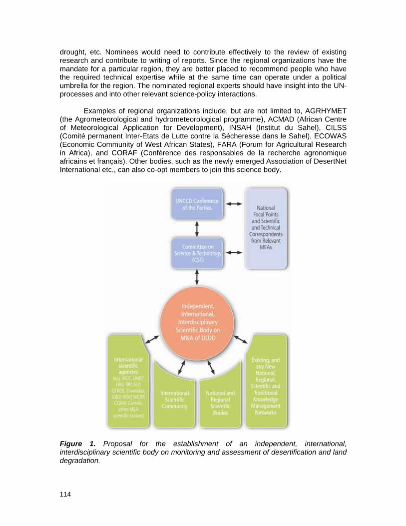
114
drought, etc. Nominees would need to contribute effectively to the review of existing research and contribute to writing of reports. Since the regional organizations have the mandate for a particular region, they are better placed to recommend people who have the required technical expertise while at the same time can operate under a political umbrella for the region. The nominated regional experts should have insight into the UN-processes and into other relevant science-policy interactions.
Examples of regional organizations include, but are not limited to, AGRHYMET
(the Agrometeorological and hydrometeorological programme), ACMAD (African Centre of Meteorological Application for Development), INSAH (Institut du Sahel), CILSS (Comité permanent Inter-Etats de Lutte contre la Sécheresse dans le Sahel), ECOWAS (Economic Community of West African States), FARA (Forum for Agricultural Research in Africa), and CORAF (Conférence des responsables de la recherche agronomique africains et français). Other bodies, such as the newly emerged Association of DesertNet International etc., can also co-opt members to join this science body.
Figure 1. Proposal for the establishment of an independent, international, interdisciplinary scientific body on monitoring and assessment of desertification and land degradation.

115
Thus, a science assessment body to assist the UNCCD should be comprised of internationally renowned and experienced scientists who share collaborative and integrative approaches to problem-solving. The presence of development professionals with real-world experience in relevant ecosystems and cultures would be of significant benefit to the science body. Broadly knowledgeable and experienced individuals can be more effective than narrowly-focused scientists with less integrative experiences. A science body will always have the option of seeking very specific technical advice from outside sources. Specific skill sets that should be considered for inclusion in the science body are:
• Biophysical: geology, soils, hydrology, fluvial geology, remote sensing, spatial ecology, global change ecologists.
• Socio-economic (classical and ecological): economists, sociologists, anthropologists and/or political scientists that deal with culture, decision-making processes, and policy.
• Management and rehabilitation of arid ecosystems: rangeland scientists, ecological restoration.
• Data assimilation: collection and development of novel and appropriate statistical approaches to compare disparate data collected in different ways and for different purposes.
The ideal format of a science body is often achieved after thorough debate. For
example, the Subsidiary Body on Scientific, Technical and Technological Advice (SBSTTA) of the CBD has become the centre of heated debates concerning its function as the science-policy interface of the Convention. As the quality of SBSTTA's work depends primarily on the processes that guide the discussions during its meetings and on the material on which these discussions are based, Koetz et al., (2008) suggest that SBSTTA (i) improve its scientific foundation by systematically strengthening its relations to more scientific institutions outside the formal CBD regime, and (ii) focus on providing a more substantive political debate to resolve alternative policy choices during its meetings.
Scientific interchanges on the inter-connecting topics must be open, transparent,
representative and legitimate. The results and analysis need to be policy-relevant but not policy-prescriptive, providing options, not recommendations. Plausible scenarios for the future should be relevant for policy-formulation over a range of spatial scales, from local to regional and global. The conclusions must be evidence-based and not value-laden, and finally, must cover risk assessment, management and communication.
Scientific assessments produced by bodies need to involve and reach out to all
key decision-makers within governments, not just the environment ministries which are often one of the least powerful ministries (Watson, 2005), including the finance, energy, transportation, and agriculture ministries. To illustrate what types of information may be policy-relevant, Watson (2005) uses the example of the MDG Task Force on Environmental Sustainability which addresses a number of key environmental issues. Similar questions posed by the Task Force for each environmental issue could be used for the proposed assessment body:
• What is the problem (e.g., desertification, land degradation, rehabilitation of degraded lands)?

116
• What is the impact of the environmental problem on the other MDGs (e.g., how does desertification, land degradation affect poverty and hunger)?
• What are the major drivers of desertification and land degradation globally and regionally?
• What needs to happen at the local and global levels to address the environmental issue?
• What actions are needed to avoid land degradation and what actions are relevant for national governments, local governments, the private sector, NGOs, foundations, etc.?
• What are the costs of action and inaction?
Watson (2005) also suggests some characteristics for a scientific assessment, including the following key recommendations:
• It must be demand driven, and involve experts from all relevant stakeholder groups in scoping, preparation, peer-review and outreach/communication.
• The process must be open, transparent, representative and legitimate. • Plausible scenarios of the future should be relevant for policy-formulation over a
range of spatial scales from local to regional and global. • The conclusions must be evidence-based and not value-laden, i.e., they must be
devoid of ideological concepts and value systems. • It must cover risk assessment, management and communication. • It must present different points of view, and whenever possible quantify the
uncertainties involved.
Although the science should be the basis of the science–policy interface for UNCCD, the assessment body should produce drafts in close collaboration with policymakers, but it should be the assessment body that has the final say on the contents of the reports. This would avoid instances where policy makers have a final say on the scientific report, one of the criticisms levelled against the IPCC. For instance, in a debate of December 1995 on the IPCC Summary for Policy Makers, the British scientist Keith Shine, one of the IPCC's lead authors, was quoted as saying "We produce a draft, and then the policymakers go through it line by line and change the way it is presented.... It's peculiar that they have the final say in what goes into a scientists' report". In a nutshell, the scientific assessment body to support the UNCCD should, as much as possible, be devoid of political interference in order for its assessments and reports to remain relevant, accurate, timely and credible.
4.2. Issues of Scientific Independence and Policy Relevance The assessment body should be independent of the UNCCD for reasons of credibility and openness. Ideally, as mentioned above, it should be housed in another international organization and be composed of scientists nominated by national governments and regional organizations, not by the UNCCD COP or CST. While there are members of the IPCC who are government-appointed scientists, they are still independent of the UNFCCC and this should also be the case for any new scientific body on land degradation. Based on international consultations and the discussions at the UNCCD First Scientific Conference in Buenos Aires in September 2009, an e-forum is currently being established by the Association of DesertNet International and UNU-INWEH to

117
further facilitate scientific discussions and details on the needs and options of an international and independent scientific panel on land degradation and desertification. As agreed with the CST Secretariat, the results of this international e-consultation will provide input to the CST Secretariat to support the follow-up of the conference results to the CST SS-2 in 2010 which will be making recommendations to COP10.
The UNCCD may want to consider the IPBES's emerging principles, whose key operating principles stipulate that it shall be (UNEP/IPBES/1/4):
i) Inclusive of intergovernmental, governmental and non-governmental stakeholders and built upon existing networks of scientists and knowledge-holders;
ii) Scientifically independent, credible and subject to critical expert peer review as appropriate;
iii) Responsive to policy needs as identified by decision-making organizations at multiple levels, including biodiversity and ecosystems-related Multilateral Environmental Agreements and relevant intergovernmental bodies, by being legitimate and policy-relevant without being policy-prescriptive;
iv) Underpinned by experiences of relevant assessment processes; and v) Monitored from the outset with procedures for measuring its effectiveness.
4.3. Possible Structural Elements for a Scientific Assessment Body The structure of the proposed scientific assessment body should be lean, comprising members chosen with due regard to the principles of equitable geographical distribution and gender and discipline balance, and should have clear terms of reference. A four or five-year cycle approach could be undertaken for the implementation of its work programme. This will enable stakeholders to evaluate and monitor the platform’s progress, performance and success. Specific activities to be undertaken in each work cycle will be determined in plenary. It is proposed that participants draw up a set of recommendations to be presented to the UNEP Governing Council/Global Ministerial Environment Forum for its consideration, or other similar body willing to take on this responsibility.
Vlek (2005) recommended one type of structure. He proposed that such a body could be composed of three working groups and a task force. Somewhat parallel to the IPCC division of labour, Working Group I would assess the scientific aspects of the soil and land system in relation to land use and global environmental change. Working Group II would assess the vulnerability of socio-economic, food and natural systems to land degradation, consequences of land degradation and options for adapting to it. Working Group III would assess options for limiting land degradation and regulating land cover change.
According to Vlek (2005), the body would meet in plenary sessions once a year to adopt reports, determine mandates and workplans for the Working Groups. Its Bureau would meet two to three times per year to assist the body’s chair in planning, coordinating and monitoring progress.

118
In addition, strong coordination between the UNCCD scientific assessment body and the IPCC could be developed and maintained. Key elements of the assessment could be organized along the lines of:
• Current and future trends in factors contributing to desertification and land degradation;
• Impacts, vulnerability, and responses to desertification and land degradation; and • Strategies to counteract desertification and land degradation.
This assessment could be conducted by the scientific community every 4-5
years, and would utilize the available science that is available by that time.
Alternatively, assessments could be done by national and regional bodies who would feed this information into the proposed scientific research body and the UNCCD. These national and regional bodies might also be extremely relevant for mainstreaming their findings in their national and regional policies, and as such, could be tasked with a more pronounced role in the proposed scientific assessment body.
4.4. Scope of Work of the Scientific Assessment Body Below, the IPCC provides a good example of how the UNCCD scientific assessment body should create a clear and concise statement of what it will and will not do:
"The IPCC does not conduct any research nor does it monitor climate related data or parameters. Its role is to assess on a comprehensive, objective, open and transparent basis the latest scientific, technical and socio-economic literature produced worldwide relevant to the understanding of the risk of human-induced climate change, its observed and projected impacts and options for adaptation and mitigation. IPCC reports should be neutral with respect to policy, although they need to deal objectively with policy relevant scientific, technical and socio economic factors. They should be of high scientific and technical standards, and aim to reflect a range of views, expertise and wide geographical coverage."
4.5. Activities of the Scientific Assessment Body A main activity of the scientific assessment body would be to provide an assessment of the state of knowledge on land degradation and desertification at regular intervals. The body could also prepare Special Reports and Technical Papers on topics where independent scientific information and advice is deemed necessary and where it could support the work of the UNCCD and, perhaps, other MEAs or UN bodies. It would support the UN through its work on methodologies for National Land Resources Inventories (Vlek 2005).
This body may also serve to improve communication between international, regional and national research and scientific institutions that would facilitate the flow of scientific information into the UNCCD implementation process.

119
4.6. Resourcing the Science Assessment Body Funding is a potentially overriding constraint, given the current state of the global economy, the resistance of donors to establishing new institutions and the fact that in 2009 a significant portion of resources that might be available for the UNCCD and other MEAs are being channelled towards climate change.
To put this in perspective, the total estimated budget requirements over the coming six years for the IPCC to prepare its fifth assessment report are approximately CHF 36 million, resulting in expected annual expenditures of approximately CHF 6 million. This is within the range of the expenditures during the fourth assessment period.5
The proposed budget for the IPBES for four years is US$ 18,435,000. The initial
four-year period is intended to involve what could be termed a relatively “light touch”. The aim is to prove the value of the platform to stakeholders, and the estimated costs are the minimum required to do this effectively. In all cases, estimated costs depend on the number of specific activities involved and the intensity of work in each activity. It is assumed that there will be two sub-global assessments at the national level in years one and three and one regional (transboundary) sub-global assessment in years two and four. National sub-global assessments are assumed to be 50% funded by national governments and 50% funded by IPBES. International sub-global assessments are assumed to be entirely funded by the platform.6 These figures could be reflective of a start-up process for a scientific body on land degradation and desertification.
Potential sources of funding include UN and related agencies (UNEP, UNDP,
FAO, IFAD) and international financial institutions, including the World Bank, the Global Environment Facility and the regional development banks. international, regional and national scientific and non-governmental organizations, foundations and national governments may also be in a position to contribute.
4.7. Outlook for a Recommendation to Form a Scientific Assessment Body to Assist the UNCCD
This proposal for the establishment of a new scientific body to support the work of the UNCCD recognizes that there may not be universal support for its establishment.
Some may argue that such a scientific body could duplicate the work of existing regional projects. According to Bauer and Stringer (2008), a scientific body that could conduct assessments would have to evaluate the LADA project and other existing projects such as the EC-funded DESIRE to avoid overlaps and benefit from any lessons learned. LADA seeks to provide insights on the status and trends of the world’s drylands and is being implemented through a partnership of UN agencies, international agricultural research centres, farmers' associations, universities, and other civil society organizations (UNEP, 2006). Duplication could be avoided if a new scientific body collaborates or otherwise works closely with existing research organizations, as well as with the IPCC and IPBES due to the linkages between climate change, biodiversity and desertification.
5 See http://www.ipcc.ch/meetings/session29/doc3.pdf. 6 See http://www.ipbes.net/Documents/work_programme_en.doc.

120
Some may argue that such a scientific body would be too expensive and that no new institutions should be established when existing institutions could do the necessary work. With this in mind, some may argue that since the IPCC is so well-established and accepted it may be worthwhile considering if the IPCC should simply be expanded to cover land degradation and desertification by establishing a new working group (Rasmussen, 2007). Some may even say that the IPBES should support all of the ecosystem-based MEAs, not just the CBD. However, if such a body were established and housed within an existing organization that could provide logistical support, there would not be any new large bureaucracies established. If an existing body, like the IPCC or IPBES (IPBES has yet to be established yet; it is under discussion under the UNEP umbrella) is used, desertification and land degradation would not receive the attention that it deserves since climate change and biodiversity issues would tend to take priority. Nevertheless, the new body should not operate in isolation. If some of the scientific bodies across MEAs could have joint meetings, or if some MEAs could share scientific bodies, this could cultivate integrated scientific discourse and build scientific capacity, especially in developing countries and at regional levels (Najam et al., 2006).
Some may be concerned that the CST would be replaced by this new body. The
new body would actually support the work of the CST and provide useful scientific assessments for the CST to consider in its deliberations. This would also follow the models of the IPCC and the proposed IPBES, which have not replaced the relevant subsidiary bodies under the UNFCCC and CBD.
It is also worth noting that if the UNCCD is truly a “bottom-up” Convention that
should rely on the co-production of knowledge, then a top-down scientific body may not be in line with the Convention’s needs. The creation of national scientific bodies, whose work would feed into the international scientific body, addresses these concerns and ensures that scientific input is “bottom-up”.
5. A Scientific Research Body Aligned with the Needs of the UNCCD As explained in the beginning of this Annex, desertification and land degradation research is highly diverse and highly dispersed at present. Therefore, a science assessment effort needs to be enabled by interlinking, catalyzing and strategically coordinating the large number of research scientists, scientific networks, institutions, and programmes relevant to the UNCCD's goals. The scientists would need to be drawn from the realms of biophysical, social, economic and political sciences.
Such a body, for example, could be formed by tapping the Earth Science System Partnership (ESSP) that already contributes substantially to the knowledge bases of sister environmental Conventions through the IPCC and the CBD. The “Global Land Project” is a recently-formed ESSP initiative which includes many prominent scientists associated with desertification and land degradation issues.7
Active involvement of scientific societies needs to be encouraged to bring
together the numerous disciplines involved in DLD. These societies have generally been rather quiet on suggesting the need for better networking of networks. In this respect, key nodal persons that can think and collaborate across disciplines need to be identified
7 See: http://www.globallandproject.org/index.shtml.

121
and encouraged to pursue greater linkages. These key persons might sit on more than one Convention subsidiary body, for example, to facilitate greater exchange and interaction.
It is suggested that an international scientific committee be formed to define the
dimensions and critical issues of the research needed to support the UNCCD and its interface with related issues (climate change, biodiversity, etc.). The two bodies proposed in this document should be interlinked so that they benefit from each other. A cost analysis should also be undertaken in order to provide donors with an estimate of the amount of resources needed for such an initiative. Furthermore, stakeholders relevant to such scientific research bodies will be interested in finding out how they can link with them and what kind of impact they can have on them. .
A scientific e-forum has been organised by DesertNet International and UNU-INWEH in the first half of 2010 in order to discuss the needs, usefulness and options of an independent, international, interdisciplinary scientific advisory body on land degradation/desertification and to explore more options on a way forward for such a body to scientifically advise the Convention in decision-making for combating land degradation and for achieving sustainable development in drylands8.
References Bauer S. and L.C. Stringer, 2009. “The Role of Science in the Global Governance of
Desertification” in Journal of Environment and Development 18: 248-267. IPCC, 2009. About IPCC. Available at: http://www.ipcc.ch/about/index.htm. Koetz, T., P. Bridgewater, S.V.D. Hove, B. Siebenhuner, 2008. “The role of the
Subsidiary Body on Scientific, Technical and Technological Advice to the Convention on Biological Diversity as science–policy interface” in Environmental Science and Policy 11:505-516.
Leemans, R., 2008. “Personal experiences with the governance of the policy-relevant IPCC and Millennium Ecosystem Assessments” in Global Environmental Change 18: 12-17.
MA, 2005. History of the Millennium Assessment. Available at: http://www.millenniumassessment.org/en/History.aspx.
Najam, A., M. Papa and N. Taiyab, 2006. Global Environmental Governance: A Reform Agenda. International Institute for Sustainable Development, Winnipeg.
Ozone Secretariat, 2004. Assessment Panels. Montreal Protocol on Substances that Deplete the Ozone Layer. Available at: http://ozone.unep.org/Assessment_Panels.
Rasmussen, Kjeld, 2007. Strategy for the United Nations Convention to Combat Desertification. Paper prepared for the Danish Development Research Network. http://www.ddrn.dk/filer/forum/File/KR_comments_on_UNCCD-210807.pdf.
Vlek, P.L.G., 2005. Nothing Begets Nothing: The Creeping Disaster of Land Degradation. Interdisciplinary Security Connections Publication Series No. 1. United Nations University Institute for Environment and Human Security, Bonn, Germany.
UNEP, 2006. Global Deserts Outlook. UNEP, Nairobi. Available at: http://www.unep.org/geo/gdoutlook/.
8 See: http://www.desertnet-international.org/.

122
Watson, R.T., 2005. “Turning science into policy: challenges and experiences from the science-policy interface” In Philosophical Transactions of The Royal Society B 360: 471-477.

123
List of Acronyms
ACIA Arctic Climate Impact Assessment ACMAD African Centre of Meteorological Applications for Development ACSAD Arab Center for the Studies of Arid Zones and Dry Lands AFD French Development Agency AGRHYMET Agrometeorological and hydrometeorological programme AOAD Arab Organization for Agricultural Development ASEAN Association of Southeast Asian Nations CAADP Comprehensive Africa Agriculture Development Programme (of
NEPAD) CBA Cost-benefit analysis CBD Convention on Biological Diversity of the United Nations CBNRM Community-based Natural Resources Management CBO Community-based organizations CEB Chief Executives Board for Coordination of the United Nations
System CEDARE Centre for Environment and Development for Arab Region and
Europe CILSS Comité permanent Inter-Etats de Lutte contre la Sécheresse dans
le Sahel CITES Convention on International Trade in Endangered Species of Wild
Fauna and Flora CLEMDES Clearing house mechanism on desertification for the northern
Mediterranean region CMS Convention on Migratory Species COP Conference of Parties CORAF Conseil Ouest et Centre Africain pour la recherche et le
développement Agricoles CSD Commission on Sustainable Development of the United Nations CSFD French Scientific Committee on Desertification CSO Civil society organizations CRIC Committee for the Review of the Implementation of the
Convention CST Committee on Science and Technology of the UNCCD DFID Department for International Development (UK) DIS-EISI Desertification Information System – Environmental Information
circulation and monitoring System DISMED Desertification Information Systems to Support National Action
Programmes in the Mediterranean DIVERSITAS International Programme of Biodiversity Science DLD Desertification and land degradation DSD Dryland Science for Development Consortium DPSIR Driver, Pressure, State, Impact, Response framework DST Decision support tools EC European Commission ECOWAS The Economic Community of West African States EMBRAPA Brazilian Agricultural Research Corporation ERR Economic Rate of Return

124
ESSP Earth Systems Science Partnership ETRC Environmental Treaties Reference Centre EU European Union FAO Food and Agricultural Organization of the United Nations FARA Forum for Agricultural Research in Africa FIRM Forum for Integrated Resource Management GBA Global Biodiversity Assessment GEF Global Environment Facility GLADA Global Assessment of Land Degradation and Improvement GPS Global Positioning System ICARDA International Center for Agricultural Research in the Dry Areas ICLD International Conference on Land Degradation ICRISAT International Crops Research Institute for the Semi-Arid Tropics ICSU International Council for Science IEPF Agence de la Francophonie/Institut de l’Energie et de
l’Environnement de la Francophonie IFAD International Fund for Agricultural Development IGAD Intergovernmental Authority on Development IGBP International Geosphere-Biosphere Programme IHDP International Human Dimensions Programme on Global
Environmental Change IISD International Institute for Sustainable Development IMoSEB International Mechanism of Scientific Expertise on Biodiversity INSAH Institut du Sahel IPBES International Panel on Biodiversity and Ecosystem Services IPCC Intergovernmental Panel on Climate Change IPES International payments mechanisms for environmental services IPFS Intergovernmental Panel on Food Security IPLS International Panel on Land and Soil IT Information Technology ITTO International Tropical Timber Organization IUBS International Union of Biological Sciences IUCN World Conservation Union IUSS International Union of Soil Sciences JWP Joint Work Programme KM Knowledge management LADA Land Degradation Assessment in Drylands LD Land degradation LLM Local Level Monitoring System M&A Monitoring and Assessment M&E Monitoring and evaluation MA Millennium Ecosystem Assessment MAB Man and the Biosphere Programme (of UNESCO) MAEE French Ministry of Foreign and European Affairs MDG Millennium Development Goals MDP Master’s in Development Practice MEA Multilateral Environmental Agreements MEDRAP Northern Mediterranean Action Programme to Combat
Desertification MEEDDAT French Ministry for Ecology, Sustainable Development and Land
Use Planning

125
MERIS Medium Resolution Imaging Spectrometer MOP Meeting of the Parties MODIS Moderate Resolution Imaging Spectroradiometer MoU Memorandum of Understanding NAP National Action Programmes NASA National Aeronautics and Space Administration (USA) NCSA National Capacity Self Assessment NDVI Normalised Difference Vegetation Index NEPAD New Partnership for Africa’s Development NGO Non-governmental organizations NICT New Information and Communication Technologies NPP Net Primary Productivity NRM Natural resources management OECD Organisation for Economic Co-operation and Development OSS Observatoire du Sahara et Sahel PES Payment for Environmental Services PESERA Pan European Soil Erosion Assessment PRSP Poverty Reduction Strategy Papers REDD Reduced Emissions from Deforestation and Degradation SBSTA Committee on Scientific and Technological Advice of the
UNFCCC SBSTTA Committee on Scientific, Technical and Technological Advice of
the CBD SCAPE Soil Conservation and Protection for Europe SID-SISEI Desertification Information Systems – Environmental Information
circulation and monitoring System on the Internet SLM Sustainable Land Management SMAP Short and Medium-term environmental Action Programme SWC Soil and Water Conservation TEMATEA Issue-based modules for coherent implementation of biodiversity
related conventions TGLP Tribal Grazing Lands Policy TNC The Nature Conservancy UMA Union du Maghreb Arabe UN United Nations UNAIDS The Joint United Nations Programme on HIV/AIDS UNCCD United Nations Convention to Combat Desertification UNCG United Nations Communications Group UNDP United Nations Development Programme UNEP United Nations Environment Programme UNESCO United Nations Educational, Scientific and Cultural Organization UNFCCC United Nations Framework Convention on Climate Change UNFF United Nations Forum on Forests UNHCR United Nations High Commissioner for Refugees UNICEF United Nations Children’s Fund UNIFEM United nations Development Fund for Women UNU United Nations University UNU-INWEH United Nations University – Institute for Water, Environment and
Health USLE Universal Soil Loss Equation WCED World Commission on Environment and Development

126
WCMC World Conservation Monitoring Centre WCRP World Climate Research Programme WG Working Group WMO World Meteorological Organization WOCAT World Overview of Conservation Approaches and Technologies WP White Paper WTA Willingness-to-accept WTP Willingness-to-pay WWF World Wildlife Fund

UNU Desertification Series No. 9
Monitoring and Assessment of Desertification and Land Degradation: Knowledge Management, Institutions and Economics
White Paper of the DSD Working Group 3
Edited by Mariam Akhtar-Schuster, Harriet Bigas and Richard Thomas
Inadequate access to data and its harmonisation and dissemination, institutional constraints, and insufficient public finances all limit local and national capacities to monitor and assess desertification and land degradation. Furthermore, monitoring and assessment is often hindered by a lack of inter-departmental and sectoral communication and insufficient information on the costs associated with prevention and reversal of land degradation.
This White Paper identifies the challenges and bottlenecks in the monitoring and assessment of desertification and land degradation in the context of knowledge management, institutions and economics. It discusses the challenges of integrating knowledge management and its practices into monitoring and assessment at various levels, and the need for doing so. It also outlines some success stories on knowledge management at the local level. This White Paper further looks at the economic and social drivers of desertification and land degradation, and how policy mechanisms are needed in order to address these issues and produce more sustainable outcomes.
The findings of this Paper were presented at the First UNCCD Scientific Conference held during the COP-9 in Buenos Aires, Argentina from 22-24 September, 2009.
ISBN 92-808-6014-3
The Dryland Science for Development (DSD) is a consortium of five partner institutions:
DesertNet InternationalEuropean Commission Joint Research Centre - Institute for Environment and Sustainability (JRC-IES)International Center for Agricultural Research in Dry Areas (ICARDA)International Crops Research Institute for the Semi-Arid Tropics (ICRISAT)United Nations University - Institute for Water, Environment and Health (UNU-INWEH)