whitton and heathfield - london borough of … · be provided via hard copy questionnaire of ......
TRANSCRIPT

Supplementary Planning Document I July 2014
WHITTON AND HEATHFIELD

Contents
1. Introduction2. Planning Policy and Wider Context3. Spatial Context4. Vision for Whitton and Heathfield5. Objectives6. Character Area Assessments7. Features and Materials8. Guidance for Development Sites9. Shop Front Guidance10. Forecourt Parking
Appendices
1. Relevant Policies and Guidance2. Street Names Character/Conservation Area

The purpose of this Village Planning Guidance Supplementary Planning Document (SPD) is primarily to establish a vision and planning policy aims for, and assist in defining, maintaining and enhancing the character of, Whitton and Heathfield Village, and to provide guidance in this regard. The SPD forms part of the wider Village Plan.
By identifying key features of the village, the SPD clarifies the most important aspects and features that contribute to local character to guide those seeking to make changes to their properties or to develop new properties in the area, as well as being a material consideration in determining planning applications.
The core of this SPD is a series of character area assessments for the component areas of Whitton and Heathfield. These character areas have been identified through the similarity of key features that are deemed to define their local character. The assessments establish dominant features and materials as well as an overall description of the street pattern and housing types.
The boundary for the SPD is based on the Village Plan areas defined by local residents through the ‘All-in-One’ survey in 2010. In the case of Whitton and Heathfield the SPD also includes the Rosecroft Gardens conservation area to avoid this being separated from other areas of related character
■ taking account of physical and administrative boundaries, including the Rosecroft Gardens conservation area boundary to avoid this being separated from other areas of related character; and
■ how local communities viewed their local areas when asked through the Council’s 2010 ‘All-In-One’ survey.
This SPD has been produced by the Council working closely with the community. This has ensured that local residents, businesses and stakeholders have been genuinely involved in defining the important features – as well as the opportunities and threats – that define their local area.
The community was initially involved through:
■ Drop in session at Whitton Youth Zone, Britannia Lane (Dec 7th 2013)
■ Resident walkabout around Whitton (Dec 8th 2013)
■ Online questionnaire (running Dec 7th to 20th 2013)
■ Stakeholder and business workshop (Jan 9th 2014)
Following the above, the draft Village Planning Guidance was consulted upon between March 14th and April 7th. Comments could be provided via hard copy questionnaire of online. A drop in session was held on March 15th at Whitton Youth Zone, Britannia Lane. Resident and stakeholder comments have been used to develop the final SPD.
The Village Planning Guidance is complementary to the wider Village Plans that have been produced for each village area, which include issues and actions for continual improvement. The SPD fulfils the aim of residents having greater control and influence over planning and development decisions in their local area, being an adopted document under the London Borough of Richmond upon Thames planning policy framework, and linking to the relevant Village Plan.
1. Introduction
Consultation events for the Whitton and Heathfield Village Plan
Whitton and Heathfield Village Planning Guidance SPD area
4 5
The London Borough of Richmond upon Thames has been divided into a series of smaller village areas.
Each village is distinctive in terms of the community, facilities and local character – as are many sub areas within the villages. The villages of the London Borough of Richmond upon Thames are attractive with many listed buildings and conservation areas, the local character of each being unique, recognisable and important to the community and to the aesthetic of the borough as a whole.
2. Planning Policy and Wider Context
2.1. Planning policy framework
National Planning PolicyThe National Planning Policy Framework (NPPF) sets out the Government’s planning policies for England and how these are expected to be applied. The NPPF is a key part of the government’s reforms to make the planning system less complex and more accessible. The framework acts as guidance for local planning authorities and decision-takers, both in drawing up plans and making decisions about planning applications. The NPPF must be taken into account in the preparation of local and neighbourhood plans, and is a material consideration in planning decisions.
Regional Planning PolicyAt a regional level, the London Plan adopted in 2011 is the overall strategic plan for London setting out an integrated economic, environmental, transport and social framework for the development of London over the next 20-25 years. This document has been adopted to ensure a longer-term view of London’s development is taken when informing decision-making, development and investment.
Local Planning PolicyThe London Borough of Richmond upon Thames current statutory planning policy framework is set out in adopted Plans which make up the Local Plan – being the Core Strategy, adopted in April 2009, and the
Development Management Plan, adopted in November 2011. There is an online proposals map and also a range of guidance provided by way of Supplementary Planning Documents (SPDs) and Guidance for the area. This SPD will form part of the planning policy framework upon adoption. There is also a range of evidence base studies that the Council has undertaken which help to guide policy making.
The Council is preparing a Site Allocations Plan (SA Plan), which will include site- specific proposals for the whole borough, other than Twickenham town centre (which is already covered by the Twickenham Area Action Plan). The SA Plan will become part of the Local Plan when adopted. The site-specific proposals in the SA Plan will look ahead over the next 15 years setting out general principles for development and be used to determine planning applications on these sites. The SA Plan sites in Whitton are included in Section 8 of this document, which goes into more detail on design objectives.
2.2. Key planning policies
SPDs cannot create new policies but expand on policies set out in higher plans, notably the Core Strategy (CS) and the Development Management Plan (DMP). This SPD relates to a considerable number of higher policies, notably:
CS Policy CP7: Maintaining and Improving the Local Environment7.B All new development should recognise distinctive local character and contribute to creating places of a high architectural and urban design quality that are well used and valued. Proposals will have to illustrate that they:
(i) are based on an analysis and understanding of the Borough’s development patterns, features and views, public transport accessibility and maintaining appropriate levels of amenity;
(ii) connect positively with their surroundings to create safe and inclusive places through the use of good design principles including layout, form, scale, materials, natural surveillance and orientation, and sustainable construction.
DMP Policy DM DC 1 Design QualityNew development must be of a high architectural and urban design quality based on sustainable design principles. Development must be inclusive, respect local character including the nature of a particular road, and connect with, and contribute positively, to its surroundings based on a thorough understanding of the site and its context.
In assessing the design quality of a proposal the Council will have regard to the following:
■ compatibility with local character including relationship to existing townscape and frontages, scale, height, massing, proportions and form
■ sustainable development and adaptability, subject to aesthetic considerations
■ layout and access
■ space between buildings and relationship to the public realm
■ detailing and materials
A full list of relevant policies is appended. Policies of note include:
CS Policy CP8: Town and Local CentresRetail and town centre uses will be supported providing that it is appropriate to the role in the hierarchy of the centres, and respects the character, environment and historical interest of the area.
CS Policy CP14 Housing - Housing Standards & Types14.D The density of residential proposals should take into account the need to achieve the maximum intensity of use compatible with local context, while respecting the quality, character and amenity of established neighbourhoods.
CS Policy CP12 River Crane CorridorThe Council will improve the strategic corridor to provide an attractive open space with improvements to the biodiversity.
DMP Policy DM HO 3 Backland DevelopmentThere will be a presumption against loss of back gardens due to the need to maintain local character, amenity space and biodiversity.
DMP Policy DM TP 9 Forecourt ParkingThe parking of vehicles in existing front gardens will be discouraged especially where:
■ this would result in the removal of architectural features such as walls, gates and paving, or of existing trees and other vegetation; or
■ where such parking would detract from the streetscape or setting of the property.
DMP Policy DM DC 7 Shop fronts and shop signsThe Council will resist the removal of shop fronts of architectural or historic interest.
DMP Policy DM HD 1 Conservation Areas – designation, protection and enhancementBuildings or parts of buildings, street furniture, trees and other features which make a positive contribution to the character, appearance or significance of the area should be retained.
DMP Policy DM HD3 Buildings of Townscape MeritPreservation and enhancement of Buildings of Townscape Merit and the Council will use its powers where possible to protect their significance, character and setting.
Policy DM TP 9 Forecourt ParkingThe parking of vehicles in existing front gardens will be discouraged, especially where
■ this would result in the removal of architectural features such as walls, gates and paving, or of existing trees and other vegetation; or
■ where such parking would detract from the streetscape or setting of the property.
2.3. Planning policy aims
This SPD reinforces the existing planning policy aims which have been established for Whitton and Heathfield, which seek to achieve the following:
Whitton Centre
■ Improve the range of shops and services in Whitton Centre and particularly encourage independent shops to improve choice develop the evening economy and avoid further provision of betting shops.
■ Maintain space for local businesses in the town centre.
■ Create a high quality public realm to make the Centre more attractive and to support the commercial function.
■ Improve car and cycle parking to support Whitton centre.
■ Improve Whitton Station and surroundings to create a high quality interchange and related public spaces.
■ Seek improvements in public transport links to Whitton Centre.
Local shopping
■ Protect local shopping parades at Nelson Road and Heathside.
Residential areas
■ Maintain and improve the residential environment through ensuring changes and extensions to houses are compatible with the character of the area.
■ Ensure new development is appropriate in terms of scale and materials and includes sufficient car parking.
■ Ensure that grass verges, street trees and other vegetation are retained and that front garden parking is limited.
Community Facilities
■ Ensure a range of community facilities which are accessible to all residents.
Open spaces
■ Protect and enhance open spaces within the area, including alongside the River Crane both as an amenity for residents and as a green corridor.
■ Provide public open space and children’s play space in areas (particularly in Whitton) which are beyond walking distance of a local park.
Other
■ Seek to minimise any adverse effects from the large crowds visiting Twickenham Stadium.
■ Improve areas which are less attractive such as service roads, blocks of domestic garages and inappropriate shop fronts.
2.4. Wider Context (Village Plans)
Village Plans have been developed for each of Richmond’s 14 villages. Each Village Plan describes a vision for the village area and identifies what the Council will do and what local people can do to achieve the vision together. It sets out the key issues and priorities and provides background information on the village area. The Village Plans are maintained on the Council’s website and are updated regularly as works are progressed. They cover a wide range of topics, including matters not within the remit of the SPD.
This Village Planning Guidance SPD forms part of the Village Plan by providing a formal planning policy document which can be used to guide new development that has responded to residents desire to have greater control and influence over planning and development decisions in their local area. The involvement of the local community in the production of the SPD has been essential in ensuring it is a genuine reflection of residents’ priorities.
6 7

3. Spatial Context
This section covers its transport, green spaces, shops and services which are an essential part of the village’s character. These are detailed below and, together with its historic assets, are mapped on the following pages.
Facilities
■ Whitton High Street district shopping centre.
■ Three smaller shopping parades, around Hanworth Road, Nelson Road and Powder Mill Lane.
■ Mill Farm Business Park.
■ Whitton Library and Whitton Restroom.
■ New youth centre along Britannia Lane behind Whitton High Street.
■ Whitton Community Centre & Social Club.
■ Whitton Sports and Fitness Centre (located at Twickenham Academy).
■ Three GP surgeries and the new Whitton Corner Health and Social Care Centre.
■ The area has a number of schools.
■ Murray Park Hall, located in Murray Park, provides space for community activities.
Green infrastructure
■ Murray Park, which has a new skate park, temporary FitPoint and playground equipment facilities.
■ Hounslow Heath Open Space and Heathfield Recreation Ground on Powdermill Lane.
■ Crane Park is an important green space in the area and includes the Shot Tower, which is grade II-listed and the only surviving building from the old Hounslow Powder Mills. The Park has recently benefited from £400k investment from the Mayor of London which saw both sides of the River upgraded.
■ Whitton Park is home to a growing hub of sports clubs.
Connectivity and accessibility
■ A range of cycling routes including cycleways down the A314 Hanworth Road.
■ The London Loop long distance recreational walking routes lies on the boundary of the Whitton and Heathfield Village area and runs along the River Crane.
■ Bus services - a number of buses serve the area, including the 481 from Kingston to West Middlesex Hospital.
■ Rail services - Whitton Rail station is on the Hounslow Loop with trains running direct to London Waterloo and Windsor and Eton Riverside. Trains to Reading, Ascot and Bracknell can also be accessed from Whitton via Feltham.
Conservation and heritage
Whitton and Heathfield Village contains one conservation area, Rosecroft Gardens (locally known as the Dene Estate). Kneller Hall is a Grade II Listed Building and there are also a number of Buildings of Townscape Merit which are clustered around the High Street and along Nelson Road / Kneller Road.
8 9
Facilities in Whitton and Heathfield

10 11
Connectivity and Accessibility in Whitton and Heathfield
Green Infrastructure in Whitton and Heathfield

© Crown copyright and database rights 2012Ordnance Survey 100019441LegendSPD Boundary
Conservation Area
Building Of Townscape Merit
Listed Buildings
Historic Assets in Whitton and Heathfield
Note that Archaeological Priority Areas are recorded in the Development Management Plan
Overview
The Whitton and Heathfield Village Plan area brings together these two wards, which share a predominance of similar features, most recognisably being 1930s interwar semi detached terrace housing, along with terraced houses, bungalows and the High Street which is one of the finer examples of 1930s high streets in London and retains many original features. North east of the High Street finds a cluster of historic properties, notably the Grade II Kneller Hall and Kneller Road properties.
Character area assessments
The identification of the local character is one of the primary objectives of the SPD.
The character area assessments sub-divide the village into a smaller set of sub areas, some of which are further sub-divided.
Each has been identified by grouping properties with similar characteristics, features and materials which have been identified and captured.
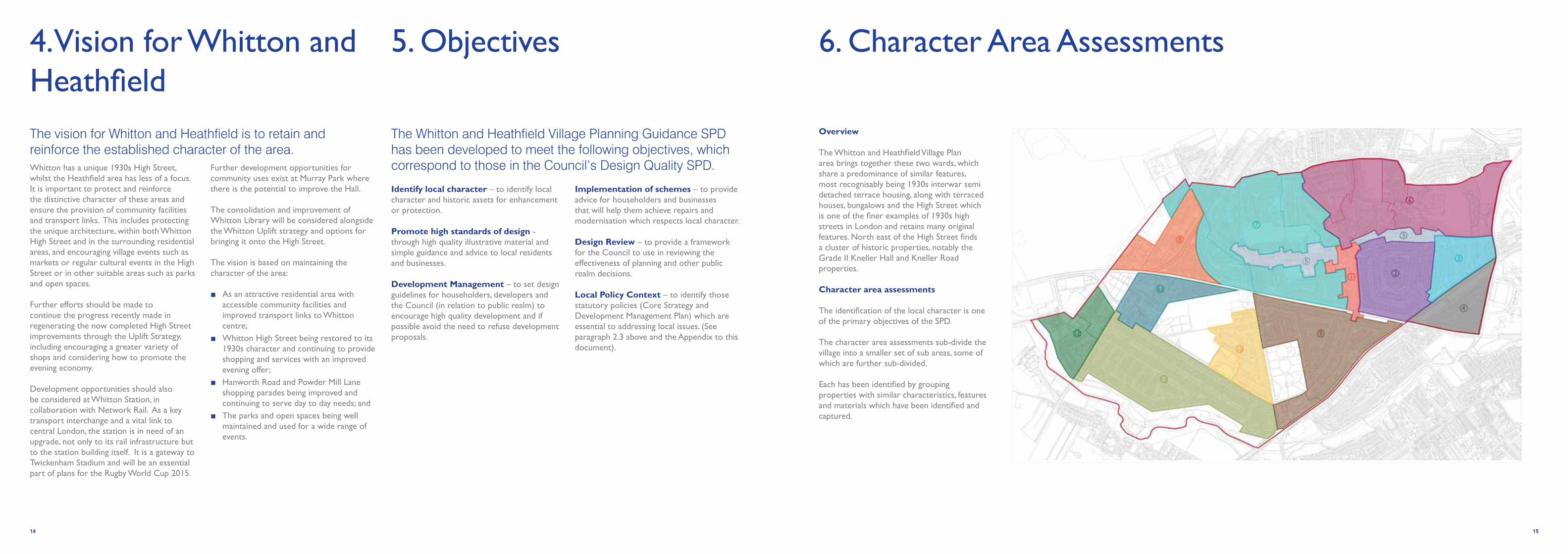
4. Vision for Whitton and Heathfield
5. Objectives
Whitton has a unique 1930s High Street, whilst the Heathfield area has less of a focus. It is important to protect and reinforce the distinctive character of these areas and ensure the provision of community facilities and transport links. This includes protecting the unique architecture, within both Whitton High Street and in the surrounding residential areas, and encouraging village events such as markets or regular cultural events in the High Street or in other suitable areas such as parks and open spaces.
Further efforts should be made to continue the progress recently made in regenerating the now completed High Street improvements through the Uplift Strategy, including encouraging a greater variety of shops and considering how to promote the evening economy.
Development opportunities should also be considered at Whitton Station, in collaboration with Network Rail. As a key transport interchange and a vital link to central London, the station is in need of an upgrade, not only to its rail infrastructure but to the station building itself. It is a gateway to Twickenham Stadium and will be an essential part of plans for the Rugby World Cup 2015.
Further development opportunities for community uses exist at Murray Park where there is the potential to improve the Hall.
The consolidation and improvement of Whitton Library will be considered alongside the Whitton Uplift strategy and options for bringing it onto the High Street.
The vision is based on maintaining the character of the area:
■ As an attractive residential area with accessible community facilities and improved transport links to Whitton centre;
■ Whitton High Street being restored to its 1930s character and continuing to provide shopping and services with an improved evening offer;
■ Hanworth Road and Powder Mill Lane shopping parades being improved and continuing to serve day to day needs; and
■ The parks and open spaces being well maintained and used for a wide range of events.
Identify local character – to identify local character and historic assets for enhancement or protection.
Promote high standards of design - through high quality illustrative material and simple guidance and advice to local residents and businesses.
Development Management – to set design guidelines for householders, developers and the Council (in relation to public realm) to encourage high quality development and if possible avoid the need to refuse development proposals.
Implementation of schemes – to provide advice for householders and businesses that will help them achieve repairs and modernisation which respects local character.
Design Review – to provide a framework for the Council to use in reviewing the effectiveness of planning and other public realm decisions.
Local Policy Context – to identify those statutory policies (Core Strategy and Development Management Plan) which are essential to addressing local issues. (See paragraph 2.3 above and the Appendix to this document).
The vision for Whitton and Heathfield is to retain and reinforce the established character of the area.
The Whitton and Heathfield Village Planning Guidance SPD has been developed to meet the following objectives, which correspond to those in the Council’s Design Quality SPD.
14 15
6. Character Area Assessments

16 17
Whitton High Street
Whitton High Street
Whitton Station
Character Summary
This area takes in Whitton High Street from the railway bridge to the south up to the junction with Nelson Road to the north. Its character remains reasonably intact. The High Street is almost exclusively made up of 1930s parades and has a strong architectural character which is quite distinct from the rest of Whitton.
The High Street is an example of a well-preserved 1930s high street in London. The area was originally planned for housing, however in 1930 new plans were submitted for a parade of 45 shops and businesses to line Percy Road (now known as the High Street). The buildings are generally low-rise – they don’t rise above three storeys – and are almost exclusively in red brick. They display the architectural tastes of the time; Neo-Georgian, vernacular and deco are all identifiable strains.
Architectural landmarks demarcate the High Street at either end with the railway bridge to the south and its contemporary, The Admiral Nelson public house to the north. These are important anchors at either end of the High Street. The station in particular generates important local footfall to the High Street, as does the car park off Library Way. From the south, the railway bridge is located at a higher point and the street gently curves creating a long vista looking north.
From the northern end of the High Street The Admiral Nelson, Fourways House, the 1960’s development at ‘16-30 High Street’ and ‘78 High Street’ frame the view and sense of arrival from Nelson Road.
Buildings and shops on the High Street have been developed as long, uninterrupted blocks built to curtilage. Pavements are wide and local shops and business often use their threshold as ‘spill-out’ space for seating and displaying goods. Service vehicle access is located to the rear (off the High Street).
Residential streets have been planned (Tranmere Road, Constance Road and Bridge Way) with tree lined streets creating attractive views from the High Street. At the junction of these streets, buildings have angled corners which form an architectural feature. Linking routes to the High Street from the surrounding residential areas provide important access (and local residents report that they often walk to the centre).
Character Area 1: The High Street
Character Area 1: The High Street

18 19
A public realm scheme on the High Street is currently underway (2014), having started in 2013 and the works are of notably good quality.
The improvements include:
■ Repaving of footways and forecourts to shops in York stone, with improvement of crossing points;
■ New street lighting scheme (32 columns) in 1930s style to relate to the age of the buildings;
■ New street furniture (seating, litter bins, cycle stands, guard rail replacement etc.); and
■ Additional tree planting.
Although unified by their materials, the forms of the buildings are distinctive and add to the character of the High Street. The vernacular-inspired parades with their gables and steeply-pitched, tiled roofs have a softening effect opposite the taller, Neo-Georgian elevations with their pilastered upper-floors. Further north, is a more modernist three-storey parade with a sleek balcony on the top floor. Some unsympathetic alterations have been undertaken, particularly in terms of shopfronts, signage and window replacements, which detract from the streetscape and individual style of the parades.
There are some interesting surviving shopfronts (e.g. No.15, HSBC and 78 High Street) a few of which still have their tesserae (mosaic) thresholds. A shopfront improvement scheme is underway. The original, distinctive street signs survive and should be retained and restored.
There are two potential areas where development could take place at the northern and southern ends of the High Street – Whitton Station and the area around the car park off Library Way. These are covered in more detail in Section 8.
Dominant Materials and Features
■ Red brick laid to flemish bond
■ Pitched and hipped roofs, clay-tile roofs
■ Vernacular detailing including: timber shutters; timber casements; gables, steeply-pitched clay tile roofs
1930s detailing includes
■ Concrete dressings
■ Tall timber or metal windows
■ Pilasters
■ Pediments
■ Black granite stall-riser
■ Chrome frame
■ Awning and brackets
■ Recessed doorway with black granite flank wall cladding and mosaic floor tiling
Character Area 1: (continued)The High Street
WT1
WT1: Kneller Hall Telephone Exchange
WT2
WT2: Whitton ‘block’ library
WT3
WT3: Iceland

20 21
Character Area 2: Hazel Close, Redway Drive and surrounds
Crane Way
Character Summary
To the east of the High Street and south of Warren Road is a residential area with a distinctive layout of interconnecting, curving streets. Hazel Close is almost an oval shape at the centre of Area 2 with concentric streets surrounding it. The urban design of this area appears to have been undertaken comprehensively and is of a style typical for this era. The pattern of development is laid out in a manner that originated with the Garden City movement (Whitton grew as a London suburb, following the development of Whitton railway station). Streets are ‘organic’ rather than symmetric.
The houses and bungalows at the centre (Hazel Close) are largely detached with a few individual designs that have an Arts and Crafts flavour, as well as a number of well preserved semi detached bungalows on The Ridge notable by their half timbering, original boundary walls with iron gates and brickwork. Moving out from Hazel Close, the buildings become more uniform in design and more densely planned as semi-detached pairs and terraces.
Collectively the housing and urban planning of this area constitutes one of the better preserved examples of 1930s development in Whitton, even though changes have happened.
■ Buildings are either single storey bungalows or two storey houses
■ Usually semi-detached, pairs and rows of housing which have been symmetrically designed There is a diverse collection of building styles. Styles often alternate in pairs
■ Properties have well defined boundaries, with front gardens and low boundary walls fronting the pavement
■ Consistent building lines ■ There are street trees throughout the
area ■ There are rear access roads off a number
of streets
Dominant Materials and Features
■ Applied half timbering, red brick and clay tiles. Some instances of pebbledash. A white/light coloured render is sometimes used on the upper storey
■ Double bay windows with red tiles or black and white half timbering
■ Gables, pitched roofs often hipped, chimneys
■ Front gardens, low boundary brick walls
■ White window frames, oriel windows
■ Simple flat roofed canopies to front doors (cantilever)
Hazel CloseThe Ridge
Character Area 2: Hazel Close, Redway Drive and surrounds

22 23
Character Area 3: East of Hall Farm Drive
Character Summary
This area is relatively close in character to Area 2 with its vernacular-inspired housing but is less cohesive as the designs are more varied. The area is composed of a series of streets which run north-south off Kneller Road. The diversity of semi-detached building styles defines this area’s character. However, whilst diversity exists in terms of design, a consistent palette of complementary materials and tones were originally applied. To the south of the area are a few later, c.1970s semi-detached pairs or short terraces. This 1970s housing has less detailing, however they have adopted some 1930s design principles such as the hung tiles on the front elevations.
The rest of the roads are characterised by inter-war housing. On Hall Farm Drive takes the form of short terraces, whilst elsewhere semi-detached pairs predominate. There are some instances of properties on streets from Godfrey Avenue to Kendrey Gardens having undergone a degree of adaptation but changes are in the main to front boundary walls and the conversion of front gardens to car parking. On Hall Farm Drive this is more prevalent. Front boundaries are less well defined. In particular the front walls have been removed to maximise hard standing thus reducing the areas of soft landscaping.
■ Hall Farm Drive: short, two-storey terraces with central, pedimented gables with applied half-timbering. Pitched and hipped roofs with chimneys. Brick plinth and pebbledash (different shades or render have more recently been used). Double bay projection. Roundels and slot windows. Brick front garden boundary walls (to match plinth).
■ Godfrey Avenue to Kendrey Gardens: semi-detached, two-storey pairs with pitched and hipped roofs and bay/bow windows. A variety of different elevational detailing (tends to be paired). Front gardens with planting and low brick boundary walls.
Dominant Materials and Features
■ Red brick, pebbledash/rendering, clay tiles
■ Half-timbering to porches, chimneys
■ Distinctive brickwork, especially on Kendrey Gardens e.g. quoins and arches over recessed doorways
■ Unusual fenestration, including roundels and slot windows, oriel windows
■ Views northwards to the grounds of Kneller Hall
Hall Farm Drive
Whitton Chase GardensKendrey Gardens
Character Area 3: East of Hall Farm Drive

24 25
Conservation Area 4: Rosecroft Gardens (known locally as the Dene Estate)
The conservation area is located to the south of Chertsey Road, north of the railway line and bounded to the east by the Duke of Northumberland’s river. It covers all the houses within the estate, known locally as the Dene Estate. The conservation area is a distinctive example of a 1930s model housing estate, of semi-detached and detached bungalows set in gardens to front and rear. The layout of the estate is on a triangular plan and it is accessed only from the Chertsey Road. Rows of bungalows in garden plots to front and rear are set back from their boundaries behind small front gardens, either planted or with hard surfacing. The original treatment of boundary walls was low, stone built with piers.
There are important gaps between buildings, often allowing access to rear garages. The bungalows were originally mainly of painted render over brick plinths, with brick surrounds to doorways and a linking band course. The wider setting of open green space, the wide grass verges and trees along Chertsey Road, Crane Valley and Kneller Gardens, contribute to the suburban character of the estate. All the houses have street frontages and are placed symmetrically, set back from the street boundaries.
Dominant Materials and Features
■ Triangular shaped layout
■ Suburban location
■ Houses are set back behind small, well planted boundary walls and there are important gaps between buildings, often allowing access to side garages
■ Bungalows are painted render over brick plinths with brick surrounds to doorways and linking band course
■ Deep roofscapes
■ Curved bay windows
■ Attractive tiles and chimneys
The Rosecroft Gardens Conservation Area no. 46 Summary and Character Appraisal, Management Plan and Article 4(2) Guidance (adopted 18th September 2009) should be referred to.
http://www.richmond.gov.uk/conservation_area_study
Rosecroft Gardens
Rosecroft GardensRosebine Avenue
This provides a summary of the main characteristics of the conservation area. More detailed information can be viewed using the link provided below.
Conservation Area 4: Rosecroft Gardens

2726
Character Area 5: Nelson Road / Warren Road
Character Summary
Area 5 includes sections of Nelson Road (B358) and Warren Road (B361) and is characterised by its function as a key route through Whitton. From the east and from the west there is a sense of arrival (albeit subtle and signage is limited). This route connects to the northern end of Whitton High Street.
The area contains a diverse mix of buildings, styles of architecture and palette of materials from different eras.
The area is predominantly residential but there are pockets of other uses along the route, including a parade of local shops and two primary schools.
On the whole, buildings are set back from the property’s front boundary. Many of the houses have an area of hardstanding for car parking at the front. The treatment of front boundaries is varied and the types of materials are mixed (where not removed to provide access for car parking). However, where still in place, boundaries are generally formed by low walls. Street planting is limited.
There are pockets of housing along this route that are noted locally for their history and which have created an interesting and diverse mix of property styles. For example, a row of 5 bungalows on Warren Road (opposite Redway Drive) which are reported to have been built by James Wills for his 5 daughters in the 1920s and blocks of housing that were
originally part of Louis Kyezor’s property portfolio.
Warren Road
Warren Road comprises mainly of 1930s two storey semi-detached or rows of housing that are set back from the main road. It is predominantly characterised by an art deco style of housing which is assumed to have been built at the same time as both sides of the street have a uniformity of architectural style. Alterations to houses have, however, impacted on this sense of unity and created a lack of consistency along the street. There are a number of front gardens that have been converted to car parking which has created a lack of consistency along the streetscape. Large areas of hard standing have over time has diminished the quality of boundaries on this frontage.
There is a small area of open space at the junction of Warren Road and Nelson Road. This is a welcome piece of green space along a main road which positively contributes to a sense of place and arrival in Whitton from the east.
Nelson Road North Side
Nelson Primary SchoolWarren Road art deco inspired design
Character Area 5: Nelson Road / Warren Road
Nelson Road
Warren Road
1
2
1
2

28 29
Character Area 5: (continued)Nelson Road / Warren Road
Dominant Materials and Features
■ 1930s art deco style rows with oriel windows, brick band course, pebble dash and red/brown brick
■ Low red/brown brick boundary walls with planting set within front gardens
■ Machine-made roof tiles; chimneys ■ Tree lined street ■ Front gardens converted to car parking
Nelson Road
Nelson Road is predominantly residential. Architectural styles are varied and reflect development during many different parts of the nineteenth and twentieth centuries, but are generally complementary and create an interesting environment. Front boundary treatments vary and lack consistency particularly where properties have converted front gardens to provide parking areas. Scale is consistent at around two storeys.
The area includes other uses such as Nelson Primary School and small pockets of local shops and services. Parking for the shops is limited and vehicles tend to park on street or on pavements where they are wide. The secondary shopping parade at 300-322 Nelson Road is of particular architectural interest for its original roof cladding feature in green glazed pantiles. An area of green open space where Nelson Road and Warren Road meet provides a welcome break in the streetscape.
Some properties have converted front gardens to car parking but many maintain an element of planting. Planting is taller in places.
Dominant Materials and Features
■ Materials are eclectic and include different coloured brick, pale render, red clay and brown machine-made roof tiles. There is variety in the roof types and elevation treatment.
■ The front boundary and curtilage of Nelson Primary School has black iron fencing, brick piers, dwarf wall, brick copings and hedgerows.
■ Properties tend to be set back from the road with front gardens, low brick boundary walls and planting defining the boundaries.
Nelson Road Street View
Nelson RoadNelson Road bungalow

30 31
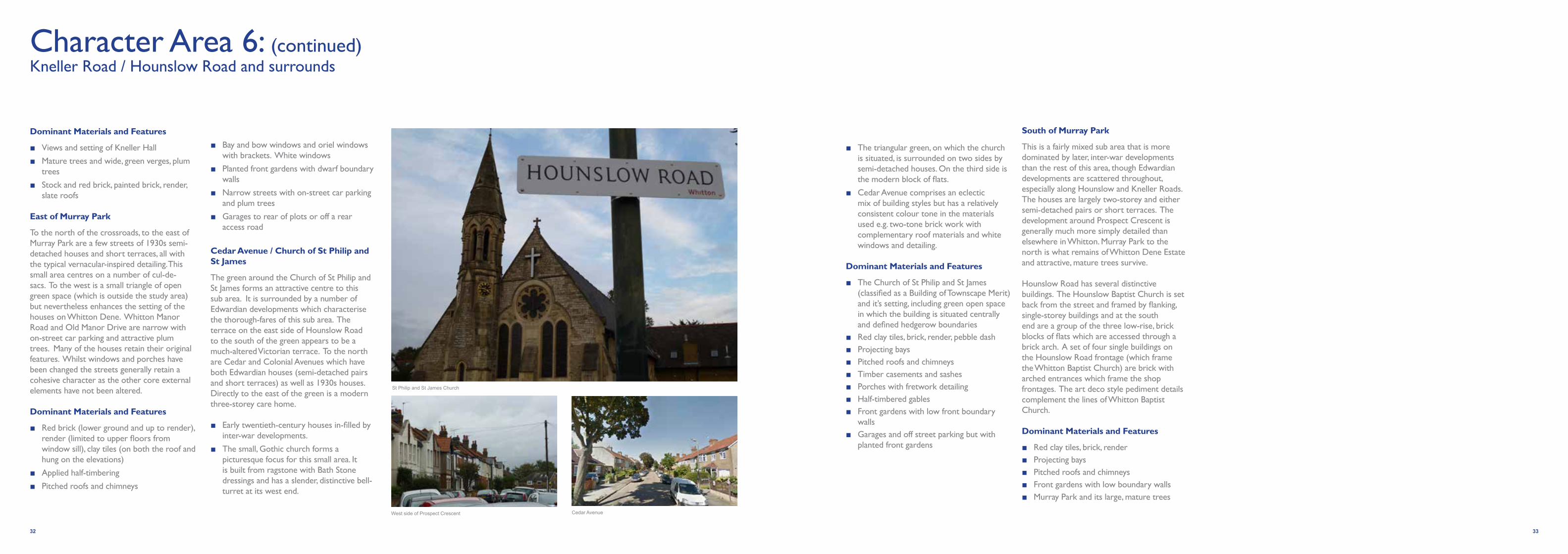
Character Area 6: Kneller Road / Hounslow Road and surrounds
Character Summary
This is the historic core of Whitton and includes a variety of building styles and residential environments. The area contains a number of distinct sub areas which each have a slightly different character from other parts of Whitton. Whilst predominantly residential, this area also contains other land uses such as shops, local businesses, public houses and open spaces. The east side of the area is dominated by the Grade II listed Kneller Hall, which is home to the Royal Military School of Music, and what remains of its park. Immediately to the west of Kneller Hall, Kneller Road and Whitton Dene meet. These are medieval routes and an historic core of buildings marks their crossroads. To the west, the area has been fairly densely developed with houses. Murray Park and the green surrounding the nineteenth-century church of St Philip and St James provide important open green spaces.
Much of the area has been in-filled with inter and post-war development but Victorian and Edwardian villas and terraces are to be found throughout this area. Kneller Hall can be seen from numerous points, with its scale and stature providing glimpse views from the surrounding areas and framing vistas.
To the east Chase Bridge primary school has been built and there has been some residential development in the remaining open space. A small clutch of historic buildings remain on the junction of Kneller Road and Whitton Dene,
The White Hart Public House and 8 Nelson Road in particular have claims to having pre-nineteenth century cores.
The former chemist’s shop/photographer’s studio is notably attractive. To the south of the crossroads is a late-nineteenth/early-twentieth century terrace of stock and red brick houses on Seaton Road, though the rest of the residential development around it is 1930s/40s housing in the form of semi-detached pairs and short terraces. As a result of incremental development and infilling the area around Kneller Hall and the cross-roads with Nelson Road/Whitton Dene in particular has suffered from piecemeal and less sympathetic development and redevelopment. This has gradually resulted in a less cohesive and attractive historic core. Buildings of Townscape Merit in this area include the Duke of Cambridge public house, the Triangle Café and The White Hart public house,
Kneller Hall (Grade II listed)
The neo-Jacobean appearance of Kneller Hall almost entirely dates from 1848. It has an impressive front elevation and its ogee cupolas can be glimpsed from the surrounding roads. The brick wall surrounding it borders on the east side of Kneller Road and the trees beyond are visible. A pocket of surviving parkland survives around Kneller Hall.
Kneller Hall
Kneller Road opposite Vicarage RoadMurray Park
Kneller Hall
East of Murray Park
South of Murray Park
Cedar Avenue
1
3
2
4Character Area 6: Kneller Road / Hounslow Road and surrounds
1
3
4
2
32 33
Dominant Materials and Features
■ Views and setting of Kneller Hall
■ Mature trees and wide, green verges, plum trees
■ Stock and red brick, painted brick, render, slate roofs
East of Murray Park
To the north of the crossroads, to the east of Murray Park are a few streets of 1930s semi-detached houses and short terraces, all with the typical vernacular-inspired detailing. This small area centres on a number of cul-de-sacs. To the west is a small triangle of open green space (which is outside the study area) but nevertheless enhances the setting of the houses on Whitton Dene. Whitton Manor Road and Old Manor Drive are narrow with on-street car parking and attractive plum trees. Many of the houses retain their original features. Whilst windows and porches have been changed the streets generally retain a cohesive character as the other core external elements have not been altered.
Dominant Materials and Features
■ Red brick (lower ground and up to render), render (limited to upper floors from window sill), clay tiles (on both the roof and hung on the elevations)
■ Applied half-timbering
■ Pitched roofs and chimneys
■ Bay and bow windows and oriel windows with brackets. White windows
■ Planted front gardens with dwarf boundary walls
■ Narrow streets with on-street car parking and plum trees
■ Garages to rear of plots or off a rear access road
Cedar Avenue / Church of St Philip and St James
The green around the Church of St Philip and St James forms an attractive centre to this sub area. It is surrounded by a number of Edwardian developments which characterise the thorough-fares of this sub area. The terrace on the east side of Hounslow Road to the south of the green appears to be a much-altered Victorian terrace. To the north are Cedar and Colonial Avenues which have both Edwardian houses (semi-detached pairs and short terraces) as well as 1930s houses. Directly to the east of the green is a modern three-storey care home.
■ Early twentieth-century houses in-filled by inter-war developments.
■ The small, Gothic church forms a picturesque focus for this small area. It is built from ragstone with Bath Stone dressings and has a slender, distinctive bell-turret at its west end.
■ The triangular green, on which the church is situated, is surrounded on two sides by semi-detached houses. On the third side is the modern block of flats.
■ Cedar Avenue comprises an eclectic mix of building styles but has a relatively consistent colour tone in the materials used e.g. two-tone brick work with complementary roof materials and white windows and detailing.
Dominant Materials and Features
■ The Church of St Philip and St James (classified as a Building of Townscape Merit) and it’s setting, including green open space in which the building is situated centrally and defined hedgerow boundaries
■ Red clay tiles, brick, render, pebble dash ■ Projecting bays ■ Pitched roofs and chimneys ■ Timber casements and sashes ■ Porches with fretwork detailing ■ Half-timbered gables ■ Front gardens with low front boundary
walls ■ Garages and off street parking but with
planted front gardens
South of Murray Park
This is a fairly mixed sub area that is more dominated by later, inter-war developments than the rest of this area, though Edwardian developments are scattered throughout, especially along Hounslow and Kneller Roads. The houses are largely two-storey and either semi-detached pairs or short terraces. The development around Prospect Crescent is generally much more simply detailed than elsewhere in Whitton. Murray Park to the north is what remains of Whitton Dene Estate and attractive, mature trees survive.
Hounslow Road has several distinctive buildings. The Hounslow Baptist Church is set back from the street and framed by flanking, single-storey buildings and at the south end are a group of the three low-rise, brick blocks of flats which are accessed through a brick arch. A set of four single buildings on the Hounslow Road frontage (which frame the Whitton Baptist Church) are brick with arched entrances which frame the shop frontages. The art deco style pediment details complement the lines of Whitton Baptist Church.
Dominant Materials and Features
■ Red clay tiles, brick, render ■ Projecting bays ■ Pitched roofs and chimneys ■ Front gardens with low boundary walls ■ Murray Park and its large, mature trees
Character Area 6: (continued)Kneller Road / Hounslow Road and surrounds
St Philip and St James Church
Cedar AvenueWest side of Prospect Crescent

34 35
Character Area 7: West of the High Street
Character Summary
This area comprises a large area of predominantly 1930s suburban housing of varying types and styles. The housing is mostly two storey semi-detached, but there is also a wider mix to be found including pockets of detached houses, short rows of terraces and bungalows. The plan form of development has grown more organically than other, more formally planned, areas of Whitton. The area north of Nelson Road was historically part of the 3rd Duke of Argyll’s estate and park, which has since been developed for housing. Some elements still exist, including a length of moat and cedar trees (near Wills Crescent). Development is then expanded south of Nelson Road.
Constance Road and surrounds
There is consistency to the style of housing on the roads surrounding Constance Road. The houses typify a 1930s style: semi-detached, red clay tiles on a hipped roof with chimney; red/brown brick ground floor/band and pebbledash; double bay frontage with peaked mock-tudor gable and red tile detailing on the bay; an oriel window above the front porch which has a brick detailed archway with keystone. Many of the houses in this area have maintained original features or have more sympathetically undertaken upgrades which are reflected in the quality of streetscape.
Park Avenue, Rydal Gardens and Runnymede Road
Inspired more heavily by the Arts and Crafts style. Whilst streets are still typically 1930s in plan form, housing along these roads have additional, more intricate and complicated detailing, which include one or more of the following: multiple pitches/steep pitch/mansard style roofs, corner windows, distinctive porches and brickwork on bay window features.
Argyle Avenue and surrounds
The area contains an eclectic mix of 1930s style housing and types including bungalows and 2 storey semi-detached and short terrace rows. Streets are tree lined with pockets of mature trees and lines of plum trees which are characteristic of Whitton. Many properties have converted front gardens to car parking introducing a more varied mix of new boundary materials and is slowly diminishing the quality of the streetscape in some areas. Front garden boundary treatment is of particular note at 245-247 Argyle Avenue and 1-7 and 2-16 on Whitton Waye. The 1930’s maisonettes located there have art deco, moulded and texture concrete piers to entrances which are mainly intact. Alterations and adaptations are common in this area; some more appropriate than others. In some cases changes, such as new windows and paint colours, have altered the consistency of the materials palette. 1930s properties tended to be designed as pairs or rows. In this area, alterations have resulted in a number of mis-matching sets.
Rydal Gardens
Constance RoadRunnymede Road
Constance Road and surrounds
Park Avenue, Rydal Gardens and Runnymede Road
Collingwood Close and surrounds
Argyle Avenue and surrounds
1
3
2
4Character Area 7: West of the High Street
1
3
4
2

36 37
Character Area 7: (continued)West of the High Street
Collingwood Close and surrounds
The area contains a mix of housing types and styles and was evidently developed following the completion of adjacent housing north of Nelson Road and east of Hospital Bridge Road and in response to the constraints of the railway line. Collingwood Close is a horseshoe shaped street and housing is less detailed than other parts of Whitton but does retain low brick boundary walls (in keeping with the housing) and planted front gardens. More recent development has also occurred where infill sites have been found.
Dominant Materials and Features
■ Typical elements include; red or brown brick at ground floor and pebbledash; white windows; bay windows; red clay roof tiles; black rain water goods.
■ Darker coloured clay or machine-made tiles are common and tend to be used on the simpler detailed properties, but not exclusively.
■ White/light coloured render would appear to be a common form of renovation works and may not have been original but is sometimes favoured over pebbledash.
■ Most of the houses are set back from the street frontage with a front garden or driveway and typically low, brick boundary wall. There are few examples of houses with garages and many have converted front gardens to hard standing for parking.
■ Generally, houses tend to be semi-detached with a double bay frontage, peaked gable with a hipped roof and chimney. Architectural detailing varies from street to street and there is not necessarily a consistent style, but there is a consistent series of details and elements that together give a sense of cohesiveness. Details include: porches or lean-to’s, oriel windows, detailed brick work on doors or bays, red tiles on bays, detailing on front gables, multiple pitches on roofs.
■ There are examples of houses which reflect the Arts and Crafts and mock-tudor styles.
Evelyn Close
Park AvenueDerwent Road
38 39
Character Area 8: Egdar Road / Conway Road / Feltham Triangle Estate
Character Summary
This area contains a variety of development styles from different eras from the 1930s to the present day and has therefore been divided into various sub areas. The development of this part of Whitton and Heathfield came slightly later than other areas in the village. As a result it is a little more piecemeal and less consistent in terms of house types compared to other areas that were planned and comprehensively developed at the same time. Of note is the dividing infrastructure of the railway line and A314 Hanworth Road. In particular, the Stephenson Road area is a large cul-de-sac enclosed by the railway lines, whilst the Edgar Road estate is isolated, being on the west side of Hanworth Road. The recreation area to the west of Hanworth Road is an important local amenity.
There are a number of different sub-areas which can be broadly described as follows:
Edgar Road Estate
The Edgar Road estate was built around the 1960s and includes low, medium and high rise development. The plan form of development is typical of the approach at the time to providing high density housing by building vertically. Buildings/living spaces are separate from open space and car parking. The area includes the single storey Edgar Road Youth and Community Centre and playground. Materials and the design of the external environment are basic and functional.
The medium and high rise buildings have recently undergone improvements and externally have been re-rendered in bright colours.
Low rise, two-three storey houses have rear gardens with a short, defensible front space and car parking on street.
Dominant Materials and Features
■ Terraced houses have buff coloured brick, brown windows, front stoop with timber lean-tos and hipped roofs
■ Maisonettes are 5 storey with pale blue, cream and terracotta coloured render, white uPVC windows
■ High rise buildings are fifteen storeys with blue coloured render and white uPVC windows.
Feltham Triangle Estate
Housing off Stephenson Road, known as the Feltham Triangle Estate, was built in the late twentieth century, resembling a Radburn style estate and comprises 2-3 storey rows of housing. There are ample areas of green space, both private and public, and some surface parking. One pedestrian access over the railway exists in addition to the Stephenson Road, the former taking residents toward the Hanworth Road retail parade.
Dominant Materials and Features
■ Brick (red, red/brown and pale buff) with red/brown machine-made cement roof tiles
■ White uPVC windows
■ Houses have front projections or canopies, timber panelling, black rain water goods, short, front defensible space, rear gardens and separate car parking usually in a court yard style
Hanworth Road area
Hanworth Road is a main road and is in a transitional zone between Whitton and Heathfield. Travelling in a southerly direction from the Nelson Road junction, traditional 1930s terraces are identifiable but development styles increasingly change and there are instances of plot infill and/or redevelopments. Architectural styles and materials are eclectic and vary from 1930s style semi-detached houses, rows of terraces , detached houses and bungalows. Conway Road and Meadow Close to the rear of Hanworth Road appear as later infill, of predominantly later terraces and some bungalows. For the most part these benefit from inter-war features such as tiled roofs and tiled/rendered facades and front and rear gardens. The north end of the Conway Road cul-de-sac has some more recent three storey flat blocks and garages.
Edgar Road
Hanworth Road
Stephenson Road
Edgar Road Estate
Feltham Triangle Estate
Hanworth Road Area
1
3
2
Character Area 8: Edgar Road / Conway Road / Feltham Triangle Estate
1
3
2

4140
Character Area 9: Percy Road / Ryecroft Avenue and surrounds
Character Summary
This area is almost entirely composed of inter-war housing with vernacular-inspired detailing, presenting many classic and well preserved examples of the architecture of the period. Most buildings are semi-detached, two-storey houses with garages. There is little evidence of any variation to the standard design through much of the east of the area (east of Ryecroft Avenue). Each house has a front and rear garden and the streets are planted with trees.
Along the Chertsey Road (A316) the semi-detached houses are post-war and much more simply detailed with pitched-roofs and elevations faced in brick and either render or timber cladding.
The southern end of Percy Road includes a number of important community buildings including the Twickenham Academy (a re-built secondary school which re-opened in 2013), the Whitton Community Association and the Whitton Corner Health and Social Care Centre. The church of St Augustine of Canterbury is also located at the southern end of the character area.
West of Ryecroft Avenue housing tends to include some art deco features such as rounded windows.
There are two sub-areas within this character area:
Percy Road, Ryecroft Avenue and surrounds
Sub-area 1 represents most of the character area and is almost all semi-detached houses with the occasional detached example. The front elevations of the majority of the houses have brick ground floors, with rendered first floors. They are two bays wide with a projecting bay under a gable. The projecting bays have hung tiles between the first and ground floor windows and the gables have decorative half-timbering. The doors are recessed under semi-elliptical brick arches and have a projecting window at first floor above.
Exceptions to this design include the post-war houses along the Chertsey Road, the Winning Post Public House also on the Chertsey Road and the small brick Methodist Church on Percy Road.
Dominant Materials and Features
■ Pitched and hipped roofs with chimneys ■ Clay tiles, render, brick, timber windows
with leaded lights ■ Gables with applied half-timbering ■ Front gardens with dwarf walls ■ Brick garages ■ Street planting
Ashley Drive and surrounds
To the west of Ryecroft Avenue are a few streets around Ashley Drive and Cranbrook Drive which have both the building type described under sub-area 1 as well as a more modernist / art deco design of semi-detached houses. These have been altered so that this original character is less apparent in some cases but there are good examples which retain curving Crittall windows and flat-roofed porches. These modern and traditional housing types are interspersed alongside one another.
Exceptions to this are the Bishop Perrin Primary School on Hospital Bridge Road which is a single-storey brick building with a slate, pitched roof with gablets at the apex.
Dominant Materials and Features
■ As sub-area 1 but including curving Crittall windows
■ Flat-roofed porches
■ Pastel colours
Strathearn Avenue
Strathearn Avenue
Pauline Crescent
Character Area 5: Nelson Road / Warren Road
Percy Road, Ryecroft Road and surroundsAshley Drive and surrounds
1
2
12

42 43
Character Area 10: Warburton Road and surrounds
Character Summary
This area lies to the west of Hospital Bridge Road and is characterised by short terraces and semi-detached pairs of largely inter-war, two-storey houses. However, the main Warburton Estate comprises 1930s London County Council style terraced cottages - with vernacular details such as clay roofs and originally casement windows.
The south side of Longford Road and the north side of Powder Mill Lane were completed after the Second World War though stylistically there is little distinction between the two phases.
The buildings are simply designed and detailed, set back from the road behind front gardens, which are in some cases now given over exclusively to car parking and resulting in the loss of the boundary walls. A feature of the estate is a series of triangular greens (Warburton Road) planted with trees to create a garden city feel to the estate. Front boundary treatments were originally chestnut picket fencing.
The terraces are largely rendered at first floor and sometimes at ground floor. In the instances where they are rendered on both floors, they tend to have a brick string course between the two.
The central bays are often finished in red brick (which have decorative elements) with a gable above. Many of the houses in the middle of the terraces have communal passages through to the rear gardens.
Where Springfield Road turns the corner into Cobbett Road the houses look over Heathfield Recreation Ground which borders the development to the east.
The Heathfield Children’s Centre and Heathfield Junior School are also included in this area.
Dominant Materials and Features
■ Pitched, hipped roofs with chimneys
■ Clay pantiles, render, brick
■ Casement windows
■ Brick detailing
■ Small green spaces, street trees
■ Front gardens with fences or low boundary walls
Hospital Bridge Road
Cobbett RoadWarburton Road
Character Area 10: Warburton Road and surrounds

44 45
Character Area 11: South of Harvey Road / Hanworth Road Retail Parade
Character Summary
This area extends east of Hanworth Road and south of the railway line towards Power Mill Lane, covering a mix of 1930s semi detached properties and bungalows alongside a range of infill development and the retail parades along the Hanworth Road and Powder Mill Lane.
Three areas have been identified; Redfern Avenue / Gerard Avenue, with largely intact inter-war stock; the residential area between Harvey Road and Powder Mill Lane, including Lea Close and Heathside with a range of typologies and infill development; and the retail parades on Hanworth Road and Powder Mill Lane.
Redfern Avenue / Gerard Avenue
Along Redfern Avenue the properties are typical 1930s semi detached dwellings with bungalows interspersed. The preservation of original detailing varies on each building. White render, red tiling and bay windows are evident although some buildings, particularly along the east of Redfern Avenue, have more predominant grey render and rounded art deco finishing suggesting later construction. As in other areas, some front gardens and boundary walls have been lost to make way for car parking.
Dominant Materials and Features
■ Pitched roofs ■ Tiles ■ White / grey render
■ Bay windows ■ Low boundary walls
Heathside, Harvey Road and Lea Close
Heathside and Harvey Road comprise a mix of 1930s semis and bungalows along with modern infill. Modern development along Harvey Road and Daniel Close takes cues from the inter-war surroundings including pitched roofs and white paint / render, unlike the Bristol Close development which is less sympathetic in design.
Heathside has a range of styles from well preserved interwar bungalows and semi-detached properties to a three storey 1970s block of flats. The pavement retains some original paving slabs and strips of tarmac, appearing rather patchwork. Atherley Way and Dunleary Close are 1970s terraces with red brick, the latter with characterful red tiling between first and second floors.
Arden Close and Lea Close are modern two and a half storey developments that have taken some features from the inter-war stock including dormer windows (Arden Close).
Hanworth Road retail parade
The Hanworth Road retail parade has been largely adapted from 1930s semi detached residential buildings, with flats retained above. The retail frontages are in a state of varying quality and repair, some incorporating security shutters. There is broad conformity to the primary shop fascia in terms of position and size
but there are further opportunities to enhance this. The public realm and streetscape appears mixed, with the roadside pavements in better condition than the area directly in front of the units. The most southern buildings appear to be of a different construction period and have a less consistent presentation. The public house is set further back and has a large outdoor area of recent construction. The building retains inter-war features including bay windows and a steeply pitched roof.
Dominant Materials and Features
■ Pitched roofs ■ Tiles ■ Render ■ Bay windows ■ Varying shop fascias ■ Security shutters ■ Resin bond surfacing
■ Alleys between buildings
Power Mill Lane parade
The Power Mill Lane parade is a terrace of inter-war and more modern stock with retail at ground and flats above. There is less conformity in the shop front fascia than on Hanworth Road retail parade, which detracts from its appearance. There is also greater use of extended canopies (of varying types) and pavement retailing, although the forecourt is resin bond rather than paved as on the north side of the road.
Hanworth Road Retail Parade
Redfern Avenue
Powder Mill Lane Parade
Redfern Avenue / Gerard Avenue
Heathside, Harvey Road and Lea Close
Powder Mill Lane Parade
Hanworth Road Retail Parade
1
3
2
4Character Area 11: Harvey Road / Hanworth Road Retail Parade
1
3
4
2
46 47
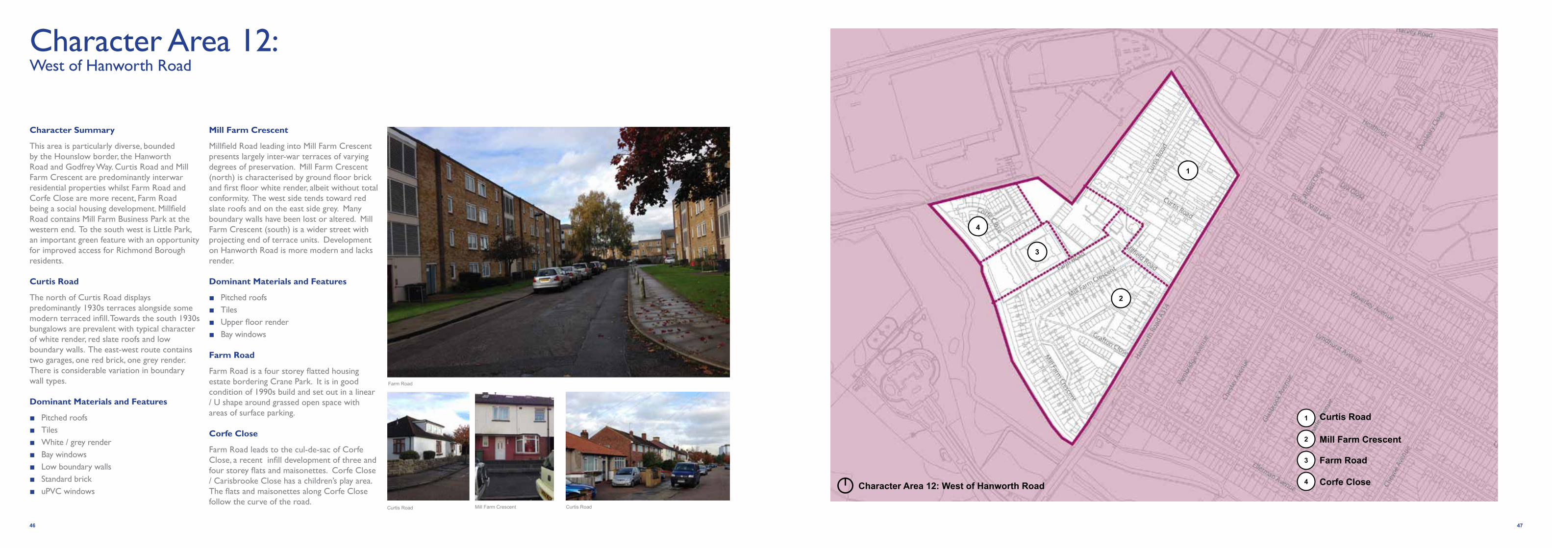
Character Area 12: West of Hanworth Road
Character Summary
This area is particularly diverse, bounded by the Hounslow border, the Hanworth Road and Godfrey Way. Curtis Road and Mill Farm Crescent are predominantly interwar residential properties whilst Farm Road and Corfe Close are more recent, Farm Road being a social housing development. Millfield Road contains Mill Farm Business Park at the western end. To the south west is Little Park, an important green feature with an opportunity for improved access for Richmond Borough residents.
Curtis Road
The north of Curtis Road displays predominantly 1930s terraces alongside some modern terraced infill. Towards the south 1930s bungalows are prevalent with typical character of white render, red slate roofs and low boundary walls. The east-west route contains two garages, one red brick, one grey render. There is considerable variation in boundary wall types.
Dominant Materials and Features
■ Pitched roofs ■ Tiles ■ White / grey render ■ Bay windows ■ Low boundary walls ■ Standard brick ■ uPVC windows
Mill Farm Crescent
Millfield Road leading into Mill Farm Crescent presents largely inter-war terraces of varying degrees of preservation. Mill Farm Crescent (north) is characterised by ground floor brick and first floor white render, albeit without total conformity. The west side tends toward red slate roofs and on the east side grey. Many boundary walls have been lost or altered. Mill Farm Crescent (south) is a wider street with projecting end of terrace units. Development on Hanworth Road is more modern and lacks render. Dominant Materials and Features
■ Pitched roofs ■ Tiles ■ Upper floor render ■ Bay windows
Farm Road
Farm Road is a four storey flatted housing estate bordering Crane Park. It is in good condition of 1990s build and set out in a linear / U shape around grassed open space with areas of surface parking.
Corfe Close
Farm Road leads to the cul-de-sac of Corfe Close, a recent infill development of three and four storey flats and maisonettes. Corfe Close / Carisbrooke Close has a children’s play area. The flats and maisonettes along Corfe Close follow the curve of the road.
Farm Road
Curtis RoadCurtis Road Mill Farm Crescent
Curtis Road
Mill Farm Crescent
Corfe Close
Farm Road
1
3
2
4Character Area 12: West of Hanworth Road
1
3
4
2

48 49
Character Area 13: Waverley Avenue / Lyndhurst Avenue and surrounds
Character Summary
This area covers a fairly large grid of parallel and perpendicular residential streets. The buildings are inter-war / post war and semi-detached pairs of either bungalows or two-storey houses, seemingly interspersed at random. Many have retained original features creating a strong sense of character whilst being differentiated by individual detailing. Particularly noticeable are half timbering, projecting bays and gable details.
The plots are generous, resulting in many of the buildings having been extended to the side. All have front and back gardens, though many of the frontages are now used exclusively for parking. The pavements are laid with concrete paviours and tarmac, and planted with trees, many of which are mature. The retention and appearance of boundary walls varies.
There are no distinct areas where the urban grain changes but there is an open, green triangle at the north-east end of Ellerman Avenue.
The area borders Crane Park to the south which follows the course of the River Crane and is valuable asset for the whole of the village in amenity and ecological terms. This area is wooded with the notable Shot Tower, which is grade II-listed and the only surviving building from the old Hounslow Powder Mills.
Heathfield Recreation Ground lies to the north of Powder Mill Lane.
Dominant Materials and Features
■ Brick, render, clay tiles, applied half-timbering
■ Pitched, hipped roofs with chimney stacks
■ Gables, projecting bays, oriel windows
■ Timber windows, with high-level emphasized (queen) transoms
■ Front gardens with dwarf boundary walls, garages
■ Street plantingWaverley Avenue
Lyndhurst AvenueElleman Avenue
Character Area 13: Waverley Avenue / Lyndhurst Avenue and surrounds

7. Features and Materials
Materials are a large part of what defines the character of an area. They vary depending on when and where a building was constructed. Even for buildings of the same period, the subtle differences in construction materials can be what distinguishes buildings in one part of the country from another, contributing to local distinctiveness.
Whitton rapidly expanded from the 1930s in response to an acute housing shortage. This was the age when millions of people moved into a modern dream home with space,light and gardens inspired by the Garden City movement. Whitton became a large, suburban residential town with a local High Street and railway station and was predominantly developed during one period. Thus the character of the area is typical of this era which saw the rise of the 1930s semi-detached house.
The architecture and style of the 1930s house is instantly recognisable. The archetypal house is two storeys, semi-detached, 3 bedroom with a typically rectangular layout. Houses have front and rear gardens and occasionally have driveways with garages. What we now call ‘kerb appeal’ and first impressions were important in 1930s housing design.
The 1930s style is an ‘old meets new’ design approach; a melting pot of traditional rural vernacular with a touch of the contemporary. The traditional mock-Tudor and Arts and
Crafts styles were often blended with twentieth century Modernism, design and construction techniques. Rosecroft Gardens conservation area is an example of where that modern design influenced the building style with rounded and streamlined feature windows. Deco inspired design is also apparent on the High Street but with few examples in the residential areas.
Whilst there is a wide array of 1930s residential styles across Whitton, certain materials and features predominate. Using the correct materials is important for any repairs, alterations or extensions to existing buildings but also for any new development if it is to respect the context and character of the area. Sourcing materials is very important, and it is always advisable to ask for samples that you can look at on site and compare with the palette of existing buildings. As Whitton was developed during one period of large scale development the materials used are consistent across the area.
Materials
Brick is a common material found throughout Whitton. In Whitton, brick is used as a facing material on front elevations. Most often, it is found on the ground floor section of an elevation – as a plinth or up to the top of the window. Brick is also used decoratively, for example, around arched doorways or herringbone brickwork panels. Importantly, the same brick was also used to construct a
low front boundary wall in keeping with the house and to clearly define the property’s boundaries. The brick bond (that is the pattern in which it is laid) is significant and adds to the subtle character of an area. Much historic brickwork is laid in Flemish bond (and this is the case on Whitton High Street) but it is important that any extensions or repairs carefully follow whatever bond the building is constructed in.
Pebbledash was particularly fashionable at the beginning of the twentieth century. Many of the houses in Whitton were originally built using pebbledash which was applied on the first floor elevation (above the brick). Many good examples of well-maintained brick and pebbledash housing remain. Throughout the twentieth century painting pebbledash or applying a smoother render became fashionable. Painted render tends to be white (or different shades of white). This method has been most successful when adjoining semi-detached houses (terrace rows or even entire streets) undergo the same treatment and use the same colour paint. When choosing to paint pebbledash or render it is important to consider neighbouring properties / the adjoining semi-detached property. It is always advisable to ask for samples that you can look at on site and compare with the palette of render colours on your street.
Timber was commonly used for doors, windows frames, eaves, lintels and bargeboards.
Applied half-timbering (usually painted black in the twentieth century) is also a common feature of the Mock Tudor style, particularly along streets such as Bridge Way. Painting timber was not just an aesthetic decision; it also protected the timber from the elements. Stripping historic timber and leaving it exposed is never a good idea. Many of the houses in the area have undergone repairs and maintenance of such features. Windows are generally white-framed in Whitton. U-PVC windows frames are now common replacements. When repairing or replacing timber features such as windows, maintaining the original style, glazing pattern and the way the window opens (casement/sash) is important. It’s worth bearing in mind that timber windows, if maintained, last indefinitely and made from a sustainable material. Timber double-glazing should always be considered if replacement is necessary as it achieves good thermal insulation whilst preserving the character of the building.
Stone is not a common feature of residential properties in Whitton and Heathfield. It does however appear on the High Street as detailing on the Neo-Georgian style blocks .
The original detailing on 1930s housing adds to their character and is easily lost. Many had decorative stained glass in the doors and windows and front gates and boundary walls also were often well-designed. It is worth considering what your property retains and if it can be repaired rather than replaced as a well-preserved house is usually also worth more.
Slit light
Casement, Crittal style windows
Fascia
Stallriser
Shutter (timber)
Top hung window
Chimney Stack Gable
Red brick laid to flemish bond
Clay tiles
Bargeboard (timber)Pitched roof
Brick parapet
Herringbone brick aprons
Pediment
Pilaster
Cornice
CapitalStone dressings
50 51

Features The 1930s houses of Whitton display a wide variety of distinctive features. It is these features that define the character of each semi-detached (pair), terrace row or even an entire street. The materials and features of each distinctive house work together; collectively they create an attractive and consistent street scene. There are examples in Whitton where this consistency of character is retained and where the alterations, adaptations and upgrading of properties which have been made have been undertaken with care and consideration.
The photographs in this section illustrate the variety of features and detailing found in Whitton.
Extensions and Alterations It is inevitable that homes need maintenance and homeowners desire to adapt their properties to suit their changing needs. This guidance is aimed at informing and encouraging those seeking to make changes to consider types of materials, features and design proposals that would be appropriate, in keeping with the character of Whitton and acceptable should a planning application be required. Advice from a council officer should be sought to assist with this process as permission may be required.
Some key considerations when thinking about adding an extension to or adapting your home are:
■ Semi-detached houses were typically designed as a pair – the features and materials usually mirror the adjoining property. The same principle applies to terrace rows. The houses tend to be symmetrical and so roof shapes, chimneys, bay projections, windows, doors and porches tend to match. The points below should assist in considering how to manage this matter.
■ Consider what elements of the house are visible from the street. Side or upper storey extensions normally work best when they are set back from the front elevation (a subtle, sometimes minimal, step back from the front building line can be enough).
■ Consider the size of an extension and whether it is too large (or too small) in proportion to the house and its features. Overbearing or oversized extensions that are out of keeping with the scale and proportions of surrounding properties would not generally be considered appropriate.
■ Building additions shouldn’t look out of place and should seek to be in keeping with the existing house. The design, build and use of materials in Whitton are still common practice in today’s construction industry. For example, there are a number of good examples of porch extensions/replacements which sit comfortably, because they have adopted suitable building lines and have chosen suitable materials that tie in with the house and neighbouring properties. Additions that do not tie in tend to detract from the property and street.
■ Avoid removing distinctive, decorative features and replacing them with plain features, for example, replacing oriel windows with plain, flat windows or rendering / painting over decorative brick panels or tiles.
■ Painting half-timbering helps to maintain the timber.
■ Retaining, maintaining and repairing original features is encouraged. However, if this is not practical, try to choose replacement materials that maintain the character of your property. For example, try to avoid uPVC windows as these are often unsympathetic in design, but if using them look for narrower and equally sized white frames with top openings.
■ Pitched and hipped roofs are common roof types for residential properties. Flat roofs are not typically found in Whitton, with the exception of garages which often have a parapet with a pediment detail.
Guidance on front gardens / forecourts is provided in Section 10.
The annotated photographs on the adjacent page and overleaf provide a guide to typical 1930s features and materials.
Pebble dash render
Side lights Red brick laid to stretcher bond
Low brick wall defining the front property curtilage
Tile hung (hanging tiles) (red clay)
Pitched and hipped roof
Oriel window (with brackets)
Applied half-timbering
Chimney stack
Red clay roof tiles
Projecting bay
7. Features and Materials (continued)
52 53
54 55
7. Features and Materials (continued)
Photograph 1
Photograph 4 Photograph 5
Photograph 2 Photograph 3
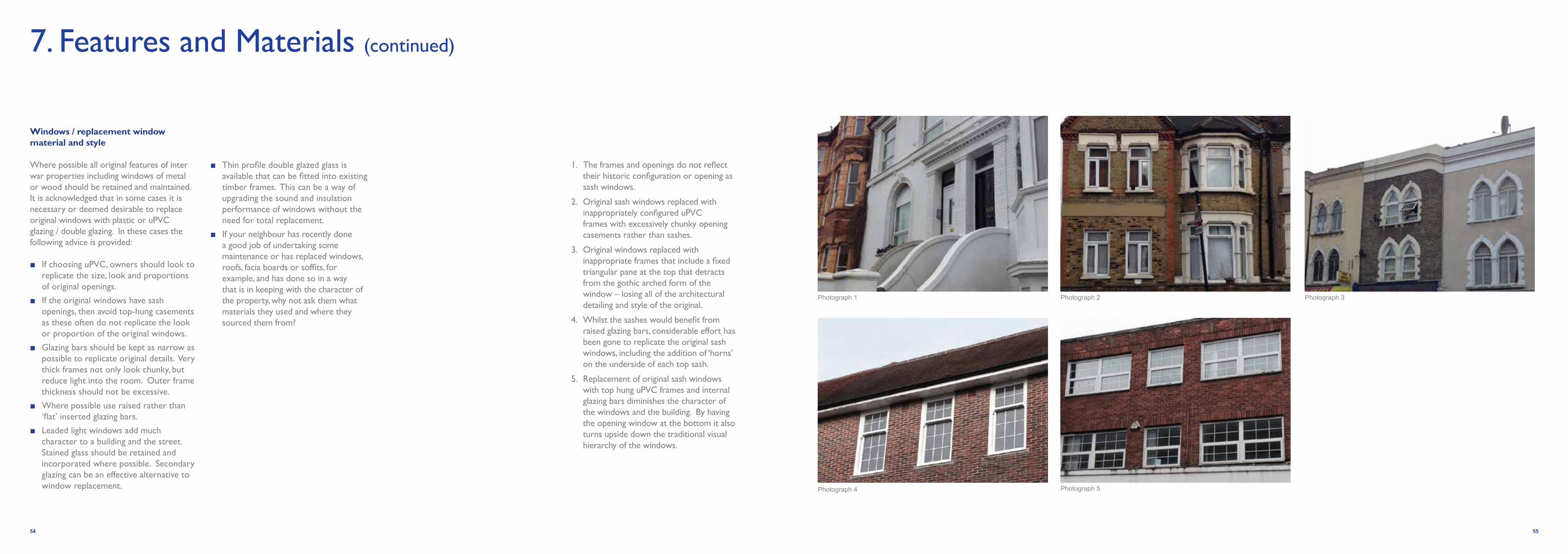
Windows / replacement window material and style
Where possible all original features of inter war properties including windows of metal or wood should be retained and maintained. It is acknowledged that in some cases it is necessary or deemed desirable to replace original windows with plastic or uPVC glazing / double glazing. In these cases the following advice is provided:
■ If choosing uPVC, owners should look to replicate the size, look and proportions of original openings.
■ If the original windows have sash openings, then avoid top-hung casements as these often do not replicate the look or proportion of the original windows.
■ Glazing bars should be kept as narrow as possible to replicate original details. Very thick frames not only look chunky, but reduce light into the room. Outer frame thickness should not be excessive.
■ Where possible use raised rather than ‘flat’ inserted glazing bars.
■ Leaded light windows add much character to a building and the street. Stained glass should be retained and incorporated where possible. Secondary glazing can be an effective alternative to window replacement.
■ Thin profile double glazed glass is available that can be fitted into existing timber frames. This can be a way of upgrading the sound and insulation performance of windows without the need for total replacement.
■ If your neighbour has recently done a good job of undertaking some maintenance or has replaced windows, roofs, facia boards or soffits, for example, and has done so in a way that is in keeping with the character of the property, why not ask them what materials they used and where they sourced them from?
1. The frames and openings do not reflect their historic configuration or opening as sash windows.
2. Original sash windows replaced with inappropriately configured uPVC frames with excessively chunky opening casements rather than sashes.
3. Original windows replaced with inappropriate frames that include a fixed triangular pane at the top that detracts from the gothic arched form of the window – losing all of the architectural detailing and style of the original.
4. Whilst the sashes would benefit from raised glazing bars, considerable effort has been gone to replicate the original sash windows, including the addition of ‘horns’ on the underside of each top sash.
5. Replacement of original sash windows with top hung uPVC frames and internal glazing bars diminishes the character of the windows and the building. By having the opening window at the bottom it also turns upside down the traditional visual hierarchy of the windows.

7. Features and Materials (continued)
Whitton’s1930s and inter-war period housing Examples of housing developed in the late 20th century in Whitton
1930’s Housing Features Adaptation and Extensions As a general rule don’t......
Modern housing which has adopted some of the characteristics of earlier housing styles
Contemporary design interpretation of projections and elevation detail (Rodney Road)
Use of red brick, render and symmetrical elements (Shelburne Drive)
Single storey bungalows with deep projections, brick plinth and matching boundary walls
Original features have been maintained including painted joinery
A pair of matching semi-detached houses Flat or pitched canopies (on brackets). The example is a flat canopy over a door with side lights
Detached housing (with alternating designs) Glazing with Deco sunbeam motif
Arts and Crafts style, multiple pitched roofs, tile detail on a pitched gable, bow window. This pair of adjoining properties have white painted render
Brick arched doorway
Red brick and applied half-timbering with oriel window and side lights Patterned brick panels and applied half-timbering (usually painted black)
Warm coloured pebbledash, white windows frames with clean lines Oriel windows
Tree lined streets and planted gardens A good example of a rear extension which is in keeping with the style of the original dwelling
Don’t extend your house with development that is dominating or out of scale. Try and retain roof lines and shape (e.g. by keeping a pitch roof)
Arts and Crafts inspired design A garage extension, replacement windows and restoration work have been sympathetically undertaken
Don’t remove boundary walls at the front of your house. If replacing or maintaining boundaries try to match the brick with your house.
Red brick and pebbledash with red hung tiles on bay projections (this property is also a good example of a well integrated extension)
The adaptation to this property has used matching bricks and maintained the brick plinth with render above. The front boundary wall is in keeping.
Chose replacement windows, soffits, barge boards, gutterings, roof tiles and doors that complement your house style. Think about mortar when re-pointing brick work.

History
Whitton High Street developed in the 1930s and many of the original buildings remain with the character reasonably intact. There are limited development opportunities but some are identified in the emerging Local Plan Site Allocations Plan (noted below).
Whitton is in the west of the Borough having a medium size food store within the High Street as well as small-scale convenience, non-food shopping and a number of local independents which serve the local community. There are community and educational facilities here, but relatively few offices compared to other centres. The station is in the main street and is a key gateway.
Policy
The Core Strategy establishes Whitton as a district centre which has an important role in meeting local needs. The strategy is to maintain the retailing and employment base functions.
Spatial Policy CS8 states that “Whitton Town centre should maintain and reinforce its role and maintain the level of service uses, encourage other use of a scale appropriate to a district centre. Increase the amount of parking when considering a retail scheme.”Development Management Plan Policy DM TC1 – Larger Town Centres – “To maintain and improve the town centres, the Council will require appropriate development to take place within the identified Whitton Town Centre boundary.”
The four sites identified within the emerging Site Allocations Plan document are located within the Whitton Town Centre Boundary.
These sites are identified for a mixed range of uses as follows:
WT 1 Whitton Library, Nelson Road, WhittonProposal: If library relocated, residential, including affordable units.
WT 2 Iceland Store, 26-30 High Street, WhittonProposal: A comprehensive redevelopment for mixed town centre uses to include residential including affordable residential, retail, services and possibly a new library, parking and servicing.
WT 3 Kneller Hall Telephone Exchange, Ashdale Road, WhittonProposal: Residential, including affordable residential units
WT 4 Whitton Station, High Street, WhittonInterchange improvements
Spatial Consideration and Development Principles
North of the High Street (Telephone Exchange, 26-30 High Street, Whitton Library)
The design and development of the northern section of the High Street should be considered comprehensively in order to contribute positively to the function of this area. The surrounding context and land uses will need to be considered. Whilst the sites identified may be developed independently, best practice urban design principles need to be applied in order to ensure the proposed developments address the functional and design needs of this part of the High Street.
These are considered in turn on the following pages.
Whitton Library
The existing Whitton Library is a single storey development on a narrow, linear plot off Library Way. The building is situated immediately adjacent to two storey residential properties and single storey garages and is adjacent to the rear servicing areas of retail units on the High Street. It is also located adjacent to the only car park in the town centre. To the rear of the building are public toilets. Pedestrian access to the High Street is via an alley next to the Lidl store.
In terms of specific features, the side elevation is poor and unwelcoming. The front entrance and elevation on Nelson Road does however add some interest with a circular shape and brick fin wall. The public realm has been recently improved.
Development Principles:
■ The building should address and enhance the Nelson Road frontage. The development should improve the aspect and streetscape on Library Way.
■ Appropriate boundary treatments should be included and where possible the public realm enhanced.
■ Respect the residential amenity of neighbouring properties.
■ Consider adjacent uses and mitigation, including the service area and car park.
■ Development should be in context with the surrounding residential properties.
■ The site should not be overdeveloped in terms of scale and massing.
■ Access is to be maintained along Library Way.
■ The design and appearance should be of quality and positively contribute to and enhance the quality of the streetscape.
8. Guidance for Development Sites
58 59
WT1
WT1: Kneller Hall Telephone Exchange
WT2
WT2: Whitton ‘block’ library
WT3
WT3: Iceland

26-30 High Street
The development block is located at the northern end of the High Street and is a row of retail units which includes the Iceland store. Should this area be redeveloped the design response needs to be comprehensively developed to achieve the planning policy objectives set out.
The existing site is different in style from the rest of the High Street having been developed in the latter part of the twentieth century with a flat roof and an alternative approach to the façade design. The building is two storeys although the front elevation only has openings at ground level. The block is located on a gently curve in the street which means that it is visible from the northern gateway (from Nelson Road). Whilst this building’s style is of its time, the height, eaves line and articulation (combined) are out of keeping with the surrounding buildings.
Buildings immediately adjacent to the site have a typically 1930s and art deco vernacular. They are three storeys (no greater). Building lines are consistent. Ground floors are active with shops front openings (even where shops have internally adapted the space to take up multiple ‘plots’). Upper storey elevations have openings and detailing. Gables, eaves and roofs have some articulation.
Development Principles:
■ The building should address the High Street and the ground floor should be active.
■ The development should respond to its context, being adjacent to the Admiral Nelson public house and prominently located within the 1930s stylised street.
■ The development should contribute to the sense of arrival (gateway) to the town centre from the north.
■ The development should be built up to the front curtilage (meet the pavement).
■ Development should be the equivalent height to the surrounding area.
■ Building lines should be consistent with the surroundings, in particular, the shop fronts and eaves/ridge lines.
■ The design and appearance should be of quality and positively contribute to, and enhance,the quality of the streetscape. The vision for Whitton town centre is to maintain and enhance the 1930s character. Alternative design proposals could be considered but should complement and enhance, not detract from, the vision.
■ Servicing should be to the rear (off Library Way). Consider adjacent uses and amenity (including residential) and whether mitigation is required.
■ Pedestrian access via the alley between the High Street and Library Way should be maintained.
■ Shopfronts and signage should be consistent with the shopfront guidance (provided in this document) and local planning policy (including the Shopfronts SPD 2010).
Kneller Hall Telephone Exchange
The site is located on Ashdale Road and is currently occupied by a telephone exchange. The surrounding area is predominantly residential. To the rear of the site is a car park off Library Way. There is no access between the site and car park. Ashdale Close is at a slightly lower level than Tranmere Road. The scale, height and mass of the telephone exchange is larger than surrounding residential buildings. The telephone exchange is two commercial storeys on Ashdale Road (which is greater than the adjacent two storey residential houses). The telephone exchange is higher at the rear extending up to three-four storeys.
Development Principles:
■ Respect the residential amenity of neighbouring properties.
■ Development should address Ashdale Road and should be no greater than (or approximately equivalent to) the existing building height on this frontage.
■ The development should maintain the existing building line on Ashdale Road (which is set back from curtilage) or should not reduce the distance to the neighbouring residential elevations.
■ Development should be a minimum of two storeys and could be up to four storeys (but
no greater than the highest point/ridge line of the telephone exchange) and subject to an appropriate design.
■ Enhance the view and boundary from the car park off Library Way.
■ The design and appearance should be high quality and respect and complement the character of the surrounding area.
Whitton Station
Improvements are proposed for Whitton Station. The station is an important gateway and anchor at the southern end of the High Street and generates important footfall for shops and businesses. The station is also regularly used by visitors travelling to Twickenham Stadium.
Development Principles:
■ The station should positively contribute to the sense of arrival in Whitton. The entrance should be attractive, safe and welcoming.
■ Public realm improvements should be high quality and be in keeping with the public realm improvements undertaken along the High Street.
■ Design and appearance should support the vision for Whitton and complement the 1930s character.
■ The station should be accessible for all users and demonstrate best practice in terms of access and inclusivity with the provision of public toilets.
Whitton Library
Whitton Station
BT Exchange
Iceland
8. Guidance for Development Sites (continued)
60 61

9. Shop Front Guidance
Introduction
The Council has an adopted Supplementary Planning Document (SPD) for Shopfronts (March 2010). The SPD sets out the policy context, when planning permission and listed building consent is needed for new shopfronts and gives Borough-wide guidance. Planning permission is invariably needed for replacement shopfronts and advertisement consent may be needed for new signage. This Village Planning Guidance SPD should be read in conjunction with the 2010 SPD which includes general rules such as “do retain and reuse existing high quality shopfronts” and “don’t propose internally illuminated box signage, large fascias or projecting signs”. (see the 2010 SPD for more information on signage, canopies and consents).
This document provides area-specific advice for the shops around Whitton and Whitton High Street. It does not replace or substitute the existing SPD on shopfronts but provides additional advice relevant to the character of Whitton and Heathfield Village area.
This Village Planning Guidance is intended to help inform owners what features of shopfronts are in keeping with the 1930s character of Whitton and Heathfield and the High Street. Good quality and attractive shopfronts enhance the character of an area and their retention is encouraged by the Council.
Proposals for shopfronts should usually be in keeping with the historic character of the buildings and this guidance encourages the retention, reinstatement and enhancement of original 1930s shopfronts. On shopfronts where replacements or adaptations are proposed (particularly to shopfronts that have already changed from the original 1930s style) this guidance requires new proposals to support the vision for Whitton and the 1930s character of the High Street as well as promoting good quality shop fronts in the round.
Whitton High Street
Whitton High Street has a strongly unified character. It was developed in the 1930s and built as a shopping street and focus for the newly expanding community. The parades display the different architectural styles that were popular at the time including Neo-Georgian, English vernacular and even Modernism.
It is a distinct area, anchored at either end by the 1930s railway bridge to the south and the Admiral Nelson public house to the north. Unsurprisingly, numerous small changes have occurred to the buildings including the replacement of shopfronts and windows but their overall character survives and is collectively worthy of preservation.
Whitton High Street was developed comprehensively over a single period. As a result, it is not only the individual shopfronts that are important but also how they work collectively.
Plots divisions, and therefore shopfront widths, are generally consistent. Where shops occupy multiple plots i.e. internally the shop has been made larger, externally shopfronts retain the division between units i.e. the pilasters which separated units are still there. This is an important feature as it creates rhythm along the street and stops long, large expanses of blank walls or windows which would not be characteristic of Whitton.
The Council has recently invested in a shopfront improvement scheme which has restored some shopfronts in a style in keeping with the original 1930s character. Shopfronts, including their signage and canopies play a significant role in creating an attractive place that people chose to visit and live. Maintaining and enhancing shop frontages will deliver longer term benefits and contribute to the quality and status of the High Street.
62 63
Top left: Foodsmiths shopfront, Hounslow Road
Top right: Centre News and Cards (shopfront improvement scheme)
Bottom left: Your Bakery Whitton
Bottom middle: Original tiled threshold (William Hill)
Bottom right: Kneller Furnishings (shopfront improvement scheme)

Character of 1930s shopfronts
The framing and essential components of shopfronts were the same as they had been in the Victorian and Edwardian periods but were far more simple.
The frames become much more slender and would often have been timber, chrome or steel. They would usually have had the overall structure of a stallriser and clerestory and recessed door that many modern shopfronts lack.
Typical 1930s shopfront features:
■ Recessed doorways / entrances.
■ Tiled detailing in the threshold and marble and mosaic used for lobby floors, black and white geometric tiles also favoured.
■ Stallrisers (with examples of dark granite).
■ Pilasters (important for subdividing units).
■ Simple, slender frames. Original examples include chrome frame detailing.
■ Black and white/cream was popular with deco shopfronts.
■ Deco style decorative detailing to windows and doors in particular.
■ Chamfered or rounded corners/windows.
■ Canopies (that match the signage).
■ Clerestory windows with decorative glazing (the more elaborate, decoration of the Victorian and Edwardian periods was no longer fashionable,instead designs were more linear and sleek).
■ The sunray motif was a fashionable one in glazing.
Although the clean lines of art deco and International Modernism are now the styles synonymous with the 1930s, more traditional strains persisted.
Art deco shopfronts, of which one very good example survives on Whitton High Street (No. 15 opposite Iceland), have a strong character typified by the use of:
■ Black with a shiny metal detailing.
■ Stallriser in black granite.
■ Tiles and the window frame in chrome / brass.
■ Fascia in timber.
Shop front signage:
Shopfront signage can have a significant impact on the appearance of the individual units as well as retail parades and high streets as a whole. The borough wide 2010 SPD covers useful guidance on signage referencing size, materials and illumination. Typical features of 1930s signage are noted here with examples pictured on the following pages:
■ Inspired by Art deco designs.
■ Bold and clear letters / typeface often all capital.
■ Typefaces include Bank Gothic, Lane – Narrow, Rider Tall, Ostrich Sans Rounded.
■ Tend towards black and white or pastiche colours.
■ Fascia signage limited to size of fascia/height of console.
9. Shop Front Guidance (continued)
6564
Deco shopfront on Whitton High Street (No.15)
Tiled threshold
Recessed doorway
Double doors
Tiled stallriser
Clerestory (obscure glass)
Chrome glazing bars
Awning with originalhinges
Timber fascia
Black granite stallriserRecessed doorway
Clerestory
Chamfered entrance
TransomTimber fascia

10. Forecourt Parking
Front Garden Parking
The Council has an existing Supplementary Planning Document (SPD) covering ‘Front Garden and Other Off Street Parking Standards’(adopted September 2006). This document provides detailed advice on the legal and design issues when creating a car parking area in your front garden and access to it from the highway. The Whitton and Heathfield Village Planning Guidance SPD draws upon the 2006 SPD, providing updated information and making specification recommendations for Whitton and Heathfield Village. It is important that the 2006 SPD is read in conjunction with the guidance below. It is also advised to refer to the London Borough of Richmond upon Thames Supplementary Planning Document on ‘Design Quality’ and the Council’s ‘Public Space Design Guide’.
In Whitton and Heathfield, as in other areas of Richmond and across London as a whole, increases in population and car ownership have resulted in greater demand for parking spaces. Where houses are not able to have garages or where there is insufficient on and off street parking this can lead to increased demand for front garden parking.
Some areas of the Whitton and Heathfield Village have experienced a significant loss of front gardens to parking in a manner that has led to a reduction of original features and an overall deterioration of the street character.
It is envisaged that this SPD can guide those seeking to make this change or to those who are make further alterations and improvements to their forecourt and front garden parking. In some instances works may be undertaken irrespective of parking – where boundaries need to be defined due to deterioration of existing or lost structures. The same principles set out below should apply.
The Council is keen that where front garden parking is necessary, it is done in the best possible way.
In many cases alterations to front gardens fall within the terms of ‘permitted development’, in which case planning approval is not required and therefore the Council has little or no control over the creation of forecourt parking. This guidance can assist those considering works under permitted development. Planning permission from the Local Authority is required in some instances (see the 2006 SPD for details).
Important features in Whitton and Heathfield
Many front gardens and frontage features in Whitton and Heathfield contribute significantly to the overall character of the area and local street scene. These include:
Boundary walls
Boundary walls enclose front gardens and define public and private space. Low walls create this space without reducing visibility. Conforming traditional brick types and brickwork along a street is an important characteristic.
Low brick boundary walls are the original inter-war suburb design, comprising of five or more layers of horizontal brick with a final upper vertical layer. Endpoints are defined with a brick pillar several bricks above the main wall. Examples of this can be found throughout the area including Waverley / Lyndhurst Avenue (Heathfield) and Hazel Close, Melrose Close and Wills Crescent to name but a few.
Iron gates and railings
Iron railings and gates are a traditional feature found in some streets. Typically railings are embedded into a lower boundary wall, creating enclosure whilst keeping visual
obstruction to a minimum. Examples of gates can be found along Albemarle Avenue. Low iron railings and detailing can be found on Chestnut Avenue, Seaton Close, Hazel Close and Mayfair Avenue.
Guidance on front garden parking
The following key considerations should be made where residents do feel an imperative to replace front gardens with car parking:
Retention of existing features
The general aim of any design for car parking in front gardens should be to retain as much of the existing features as is practical – such as existing walls, railings or hedging. Where an opening has to be made in an existing wall, railing or fence, it should be made good at both ends to match existing materials and details.
Enclosure
Retaining a form of enclosure of front gardens and forecourts is an essential part of retaining local character and maintaining the street scene. Partial loss of existing structures is inevitable to allow vehicle access but some structure should be retained. Inward opening gates help to complete a defensible line.
Permeability
The base and finished surface should be laid at a slight gradient and be of a permeable material, to allow the satisfactory drainage and absorption of rainwater. Water should drain from the property onto the footway. A length of drain or soak-away may be required at the site boundary to prevent this or a connection to a surface water sewer can be established with the agreement of the Water Authority.
Green features
Loss of existing green space may be inevitable however retaining and / or replacing some planting in as generous a manner as possible helps to maintain the area character, screen vehicles and create a more pleasant natural environment by absorbing local exhaust fumes.
Boundary wall Boundary wall
Green featuresFencing
66 67

Appendix 1: Relevant Policies and Guidance
Relevant Council document: Public Space Design Guide. Overall aim is to provide guidance to help deliver the goal of improved streetscene and public spaces. Jan 2006. Internal document that has been made public for developers etc to use.
LBRuT LDF Core Strategy (April 2009)
Main policies that the SPD will support:
CP7: Maintaining and Improving the Local Environment
7.A Existing buildings and areas in the Borough of recognised high quality and historic interest will be protected from inappropriate development and enhanced sensitively, and opportunities will be taken to improve areas of poorer environmental quality, including within the areas of relative disadvantage of Castlenau, Ham, Hampton Nurserylands, Heathfield and Mortlake.
7.B All new development should recognise distinctive local character and contribute to creating places of a high architectural and urban design quality that are well used and valued. Proposals will have to illustrate that they:
(i) are based on an analysis and understanding of the Borough’s development patterns, features and views, public transport accessibility and maintaining appropriate levels of amenity;
(ii) connect positively with their surroundings to create safe and inclusive places through the use of good design principles including layout, form, scale, materials, natural surveillance and orientation, and sustainable construction.
CP8: Town and Local Centres
8.A The Borough’s town and local centres have an important role, providing shops, services, employment opportunities, housing and being a focus for community life.
Retail and town centre uses will be supported providing that it is appropriate to the role in the hierarchy of the centres, and respects the character, environment and historical interest of the area. It should be of an appropriate scale for the size of the centre and not adversely impact on the vitality and viability of any existing centre. Out of town retail development is not usually considered appropriate in this Borough in line with The London Plan consolidated with Alterations since 2004.
The Council will improve the local environment to provide centres which are comfortable, attractive and safe for all users. The historic environment and river frontage will be protected.
CP14 Housing
Housing Standards & Types
14.D The density of residential proposals should take into account the need to achieve the maximum intensity of use compatible with local context, while respecting the quality, character and amenity of established neighbourhoods and environmental and ecological policies. The London Plan consolidated with Alterations since 2004 Density Matrix and other policies will be taken into account to assess the density of proposals.
CP20 Visitors and Tourism
The Council will support the sustainable growth of the tourist industry, for the benefit of the local area by:
20.A Encouraging the enhancement of existing tourist attractions, such as Kew Gardens, Hampton Court Palace, Ham House and the River, including sport stadia particularly those of RFU and Harlequins;
20.B Promoting sustainable transport for tourists to and within the borough,
including the passenger services along the Thames;
20.C Directing new hotels to the Borough’s town centres or other areas highly accessible by public transport;
20.D Requiring accommodation and facilities to be accessible to all;
20.E Enhancing the environment in areas leading to and around tourist destinations.
Other relevant policies:
CP10: Open Land and Parks
The open environment will be protected and enhanced. In particular:
10.A The Borough’s green belt, metropolitan open land and other open land of townscape importance, World Heritage Site (Royal Botanic Gardens,Kew), land on the Register of Parks and Gardens of Special Historic Interest, green chains and green corridors will be safeguarded and improved for biodiversity, sport and recreation and heritage, and for visual reasons.
10.B A number of additional areas of open land of townscape importance will be identified, which will be brought forward through the Development Allocations DPD.
10.D New provision will be encouraged in areas of open space deficiency at Upper
Richmond Road West, between Park Road/ Uxbridge Road Hampton Hill, Fulwell, South Twickenham, parts of St Margaret’s and parts of Whitton. All developments will be expected to incorporate appropriate elements of open space that make a positive contribution to the wider network.
CP12 River Crane Corridor
12.A The Council will improve the strategic corridor to provide an attractive open space with improvements to the biodiversity. Developments in and adjacent to the River Crane Corridor will be expected to contribute to improving the environment and access, in line with planning guidance.
CP17 Health and Well-being
17.A Health and well-being in the Borough is important and all new development should encourage and promote healthier communities and places.
17.B The provision of new or improved facilities for health and social care and other facilities will be supported. Such facilities should be in sustainable locations and accessible to all and priority will be given to those in areas of relative deprivation which are identified in Core Policy 13, an immediate need for primary health care
facilities (especially doctor’s surgeries) has been identified in Kew, Richmond, Whitton and Ham. Sites for larger facilities may be identified in the Site Allocations DPD.
17.C A pattern of land use and facilities will be promoted to encourage walking, cycling, and leisure and recreation and play facilities to provide for a healthy lifestyle for all, including provisions for open and play space within new development as appropriate.
17.D Existing health, social care, leisure and recreation provision will be retained where these continue to meet or can be adapted to meet residents’ needs. Land will be safeguarded for such uses where available, and the potential of re-using or redeveloping existing sites will be maximised.
LBRuT LDF Development Management Plan (November 2011)
Main policies that the SPDs will support
Policy DM TC 1 Larger Town Centres
To maintain and improve the town centres, the Council will require appropriate development to take place within the identified Town Centre Boundaries of the five main town centres. These are Richmond, the major centre, and the four district centres
– Twickenham, East Sheen, Teddington and Whitton.
Proposals that contribute towards a suitable mix of uses will be approved, provided that they are appropriate to the function, character and scale of the centre. Acceptable town centre uses could include retail (if within or well related to designated frontages), business, leisure, tourism, community uses, health and residential development compatible with other development in the town centre.
Proposals will be acceptable within the Town Centre Boundaries if they:
(f) Maintain or enhance the amount of active frontage, subject to Policy DM TC 3 ‘Retail Frontages’.
(h) Respect and enhance the heritage, character and local distinctiveness of the centre.
Policy DM TC 2 Local and Neighbourhood Centres and Areas of Mixed Use
The Council will protect and improve the provision of day-to-day goods and services in the local and neighbourhood centres of the borough (See Policy DM TC 3 ‘RetailFrontages’). These centres are often designated as Areas of Mixed Use and are
thus seen as appropriate for a mix of uses that meet primarily local needs.
Proposals for development will be acceptable in the smaller centres if they:
(c) Respect and enhance the heritage, character and local distinctiveness of the centre, whilst making the most efficient use of land.
(d) Include overall improvements and enhancements of the small centres; or modernise outmoded premises. Development should improve and maintain commercial provision in the smaller centres, without significantly expanding it.
Policy DM TC 3 Retail Frontages
B Secondary Retail Frontages
Non-retail proposals will be acceptable in thesecondary shopping frontages only if:
(b) The proposed use retains a “shop-like” appearance with an active frontage and will not have a detrimental visual impact on the shop-front and respect the heritage and character of the centre
68 69
Policy DM OS 3 Other Open Land of Townscape Importance
Other open areas that are of townscape importance will be protected and enhanced in open use.
It will be recognised that there may be exceptional cases where appropriate development is acceptable. The following criteria must be taken into account when assessing appropriate development:
1. It must be linked to the functional use of the Other Open Land of Townscape Importance; or
2. It can only be a replacement or minor extension of existing built facilities;
3. In addition to 1. or 2., it does not harm the character and openness of the open land.
Improvement and enhancement of the openness and character of other open land and measures to open up views into and out of designated other open land will be encouraged where appropriate.When considering developments on sites outside designated other open land, any possible visual impacts on the character and openness of the designated other open land will be taken into account.
The explanatory text is relevant to the SPD as set out below:
4.1.6 Other Open Land of Townscape Importance (OOLTI) can include public and private sports grounds, school playing fields, cemeteries, allotments, private gardens, areas of vegetation such as street verges and mature trees. The designated areas are shown on the Proposals Map but there will also be other areas which could be considered as being of local value to the area and townscape which merit protection.
4.1.7 In some parts of the borough, open areas, including larger blocks of back gardens, which are not extensive enough to be defined as green belt or metropolitan open land, act as pockets of greenery of local rather than London-wide significance. Many of these are of townscape importance, contributing to the local character and are valued by residents as open spaces in the built up area. Policy DM HO 2 ‘Infill Development’ and Policy DM HO 3 ‘Backland Development’ also recognise the importance of gardens, which will be considered as greenfield sites. Green oases are particularly important and will be protected in areas of high density development and town centres.
4.1.8 OOLTI should be predominantly open or natural in character. The following criteria are taken into account in defining OOLTI:
■ Contribution to the local character and/or street scene, by virtue of its size, position and quality.
■ Value to local people for its presence and openness.
■ Immediate or longer views into and out of the site, including from surrounding properties.
■ Value for biodiversity and nature conservation.
■ Note that the criteria are qualitative and not all need to be met.
Policy DM HD 1 Conservation Areas – designation, protection and enhancement
The Council will continue to protect areas of special significance by designatingConservation Areas and extensions to existing Conservation Areas using the criteria as set out in PPS 5 and as advised by English Heritage.
The Council will prepare a Conservation Area Appraisal and Management Plan for each Conservation area, these will be used as a basis when determining proposals within or where it would affect the setting of, Conservation Areas together with other policy guidance.
Buildings or parts of buildings, street furniture, trees and other features which make a positive
contribution to the character, appearance or significance of the area should be retained. New development (or redevelopment) or other proposals should conserve and enhance the character and appearance of the area.
Policy DM HD 3Buildings of Townscape Merit
The Council will seek to ensure and encourage the preservation and enhancement of Buildings of Townscape Merit and will use its powers where possible to protect their significance, character and setting, by the following means:
■ consent will not normally be granted for the demolition of Buildings of Townscape Merit;
■ alterations and extensions should be based on an accurate understanding of the significance of the asset including the structure, and respect the architectural character, and detailing of the original building. The structure, features, and materials of the building which contribute to its architectural and historic interest should be retained or restored with appropriate traditional materials and techniques;
■ any proposals should protect and enhance the setting of Buildings of Townscape Merit;
■ taking a practical approach towards the alteration of Buildings of Townscape Merit to comply with the Disability Discrimination Act 2005 and subsequent amendments, provided
that the building’s special interest is not harmed, using English Heritage advice as a basis.
Policy DM HO 1 Existing Housing (including conversions, reversions, and non self-contained accommodation)
Existing housing should be retained. Redevelopment of existing housing should normally only take place where:
1. it has first been demonstrated that the existing housing is incapable of improvement or conversion to a satisfactory standard to provide an equivalent scheme; and if this is the case:
2. the proposal improves the long-term sustainability of buildings on the site; and
3. the proposal does not have an adverse impact on local character; and
4. the proposal provides a reasonable standard of accommodation, including
5. accessible design, as set out in Policy DM HO 4 ‘Housing Mix and Standards’ and other policies.
Policy DM HO 2 Infill Development
All infill development must reflect the character of the surrounding area and protect the amenity of neighbours. In considering applications for infill development the following factors will be taken into account:
1. Plot width - plots must be sufficient width to allow a dwelling(s) to be sited with adequate separation between dwellings;
2. Spacing between dwelling - new dwellings must have similar spacing between buildings to any established spacing in the street;
3. Height - dwelling height should reflect the height of existing buildings;
4. Materials - where materials on existing dwellings are similar, new dwellings should reflect those materials;
5. Architectural details - new dwellings should incorporate or reflect traditional architectural features;
6. Trees, shrubs and wildlife habitats - features important to character, appearance or wildlife must be retained or re-provided;
7. Impact on neighbours - including loss of privacy to homes or gardens.
Policy DM HO 3 Backland Development
There will be a presumption against loss of back gardens due to the need to maintain local character, amenity space and biodiversity. In exceptional cases where it is considered that a limited scale of backland development may be acceptable it should not have a significantly adverse impact upon the following:
1. Garden land – rear garden land which contributes either individually or as part of a larger swathe of green space to amenity of residents or provides wildlife habitats must be retained;
2. Impact on neighbours – privacy of existing homes and gardens must be maintained and unacceptable light spillage avoided;
3. Vehicular access or car parking – these must not have an adverse impact on neighbours in terms of visual impact, noise or light. Access roads between dwellings and unnecessarily long access roads will not normally be acceptable;
4. Mass and scale of development – development on backland sites must be more intimate in scale and lower than frontage properties;
5. Trees, shrubs and wildlife habitats – features important to character, appearance or wildlife must be retained or re-provided.
Policy DM TP 8 Off Street Parking - Retention and New Provision
Developments, redevelopments, conversions and extensions will have to demonstrate that the new scheme provides an appropriate level of off street parking to avoid an unacceptable impact on on-street parking conditions and local traffic conditions.
A set of maximum car parking standards and minimum cycle parking standards are set
out in Appendix Four - Parking Standards ‘Appendix Four - Parking Standards ‘for all types of development, these take into account bus, rail and tube accessibility as well as local highway and traffic conditions including demand for on-street parking. These standards will be expected to be met, unless it can be shown that in proposing levels of parking applicants can demonstrate that there would be no adverse impact on the area in terms of street scene or on-street parking.
Policy DM TP 9 Forecourt Parking
The parking of vehicles in existing front gardens will be discouraged, especially where
■ this would result in the removal of architectural features such as walls, gates and paving, or of existing trees and other vegetation or,
■ where such parking would detract from the streetscape or setting of the property; or,
■ where the use of the access would create a road or pedestrian safety problem or
■ where the width of the proposed entrance will be greater than the width of a normal driveway.
For any proposal the area of impermeable paving should be minimised and soft landscaping maximised.
70 71

The Council will seek to restrict permitted development rights for forecourt parking through Article 4 directions, where important townscape or surface water flooding issues exist. The Council will have regard to the impact of forecourt parking in considering proposals to extend or convert existing residential property.
Policy DM DC 1 Design Quality
New development must be of a high architectural and urban design quality based on sustainable design principles. Development must be inclusive, respect local character including the nature of a particular road, and connect with, and contribute positively, to its surroundings based on a thorough understanding of the site and its context.
In assessing the design quality of a proposal the Council will have regard to the following:
■ compatibility with local character including relationship to existing townscape and
■ frontages, scale, height, massing, proportions and form
■ sustainable development and adaptability, subject to aesthetic considerations
■ layout and access
■ space between buildings and relationship to the public realm
■ detailing and materials
Policy DM DC 7 Shop fronts and shop signs
The Council will resist the removal of shop fronts of architectural or historic interest.
The Council will expect proposals for new shop fronts or alterations to existing shopfronts to demonstrate a high quality of design, which complements the original design, proportions, materials and detailing of the shop front, surrounding streetscene and the building of which it forms part.
Blinds, canopies or shutters where acceptable in principle must be appropriate to the character of the shop-front and its setting; external security grilles will not normally be permitted; in sensitive areas, rigid and gloss finish blinds will generally be unacceptable;
Signage and illumination to shop fronts must demonstrate a high quality of design, which complements the character and materials of the shop front and surrounding streetscene, and does not compromise public safety. Large illuminated fascias will not normally be permitted, even if these are in the “house style” of a particular store.
New shop fronts must be designed to allow equal access for all users, and can incorporate flood protection measures where appropriate. Proposals should take account of the Councils SPD on Shop fronts and Shop Signs.
The Council will welcome proposals from groups of shops to add character to the street scene by the use of harmonious high quality design, colours and materials for their shop fronts.
Other relevant policies
Policy DM OS 2 Metropolitan Open Land
The borough’s Metropolitan Open Land will be protected and retained in predominately open use. Appropriate uses include public and private open spaces and playing fields, open recreation and sport, biodiversity including rivers and bodies of water and open community uses including allotments and cemeteries.
It will be recognised that there may be exceptional cases where appropriate development such as small scale structures is acceptable, but only if it:
1. Does not harm the character and openness of the metropolitan open land; and
2. Is linked to the functional use of the Metropolitan Open Land or supports outdoor open space uses; or
3. Is for essential utility infrastructure and facilities, for which it needs to be demonstrated that no alternative locations are available and that they do not have
any adverse impacts on the character and openness of the metropolitan open land.
Improvement and enhancement of the openness and character of the MetropolitanOpen Land and measures to reduce visual impacts will be encouraged where appropriate.
When considering developments on sites outside Metropolitan Open Land, any possible visual impacts on the character and openness of the Metropolitan Open Land will be taken into account.
Policy DM TP 4 Integration of different types of Transport and Interchange Facilities
Developments will be expected to improve the quality and connectivity of transport interchanges of any scale, particularly in terms of
■ Opportunities for interchange between different types of transport through the provision of appropriate facilities and good information.
■ Ease of access to interchange points (e.g. stations/ bus stops) by various types of transport.
■ Transport facilities which are well laid out and allow access to a wide range of users (e.g. level or with accessible lifts or ramps).
■ Attractive and welcoming environment –
well designed civic spaces, sun and rain shelter, high quality and well maintained hard and soft landscape
■ Safe and secure environment – e.g. good lighting, CCTV, ticket barriers
Policy DM TP 6 Walking and the Pedestrian Environment
To protect, maintain and improve the pedestrian environment, the Council will ensure that:-
1. New development and schemes protect, maintain and, where appropriate, improve the existing pedestrian infrastructure, including the Rights of Way network.
2. New development does not adversely impact on the pedestrian environment and provides appropriate pedestrian access (see Policy DM TP 3 ‘Enhancing Transport Links’).
3. New development and schemes improve the safety and security of the pedestrian environment where appropriate.
Policy DM TP 7 Cycling
To maintain and improve conditions for cyclists, the Council will ensure that newdevelopment or schemes do not adversely impact on the cycling network or cyclistsand provide appropriate cycle access and sufficient, secure cycle parking facilities, see Policy DM TP 3 ‘Enhancing Transport Links’
and Policy DM TP 8 ‘Off Street Parking - Retention and New Provision’.
Relevant SPDs/SPGs
■ Design Quality SPD Adopted Feb 2006
■ Front Gardens and other Off-street Parking Standards SPD Sept 2006
■ Residential Development Standards SPD March 2010
■ Shopfronts SPD March 2010
■ Small and Medium Housing Sites SPD Feb 2006
■ Design Guidelines Leaflets 3 and 4: House Extensions and External Alterations. Adopted Sept 2002. Reformatted with minor updates July 2005. Based on UDP policies
■ Design Guidelines leaflet 11: Shopfront Security. First published 1997 and Reformatted with minor updates July 2005. Based on UDP policies
Also of relevance is the Council’s ‘Public Space Design Guide’ Jan 2006. The overall aim of the document is to provide guidance to help deliver the goal of improved streetscene and public spaces.
72 73

Appendix 2: Street names character/conservation area
Street Character Area Conservation Area
Albemarle Avenue 13Waverley Avenue / Lyndhurst Avenue and surrounds
Alton Gardens 3 East of Hall Farm Drive
Arden Close 11South of Harvey Road / Hanworth Road Retail Parade
Argyle Avenue 7 West of the High Street
Ashdale Close5 Nelson Road / Warren Road7 West of the High Street
Ashdale Way 7 West of the High Street
Ashley Drive 9Percy Road / Ryecroft Avenue and surrounds
Atherley Way 11South of Harvey Road / Hanworth Road Retail Parade
Berwick Close 10 Warburton Road and surrounds
Bird Walk 11South of Harvey Road / Hanworth Road Retail Parade
Blandford Avenue 9Percy Road / Ryecroft Avenue and surrounds
Bodicea Mews 8Egdar Road / Conway Road / Stephenson Road
Bracken Close 8Egdar Road / Conway Road / Stephenson Road
Bramley Close 6Kneller Road / Hounslow Road and surrounds
Bridge Way 2Hazel Close, Redway Drive and surrounds
Bristol Close 11South of Harvey Road / Hanworth Road Retail Parade
Britannia Lane 1 The High Street
Brunel Walk 8Egdar Road / Conway Road / Stephenson Road
Bryanston Avenue 9Percy Road / Ryecroft Avenue and surrounds
Camellia Place 7 West of the High StreetCarisbrooke Close 3 East of Hall Farm Drive
Cedar Avenue 6Kneller Road / Hounslow Road and surrounds
Chase Gardens 3 East of Hall Farm Drive
Chertsey Road
4 4Rosecroft Gardens
9Percy Road / Ryecroft Avenue and surrounds
Chester Avenue 13Waverley Avenue / Lyndhurst Avenue and surrounds
Cheyne Avenue 13Waverley Avenue / Lyndhurst Avenue and surrounds
Chiltern Avenue 13Waverley Avenue / Lyndhurst Avenue and surrounds
Cobbett Road 10 Warburton Road and surroundsCollingwood Close 7 West of the High Street
Colonial Avenue 6Kneller Road / Hounslow Road and surrounds
Coniston Road 7 West of the High StreetConstance Road 7 West of the High Street
Conway Road 8Egdar Road / Conway Road / Stephenson Road
Corfe Close 12 West of Hanworth Road
Cranbrook Drive 9Percy Road / Ryecroft Avenue and surrounds
Crane Park Road 13Waverley Avenue / Lyndhurst Avenue and surrounds
Crane Way 2Hazel Close, Redway Drive and surrounds
Curtis Road 12 West of Hanworth Road
Cypress Avenue 2Hazel Close, Redway Drive and surrounds
Daniel Close 11South of Harvey Road / Hanworth Road Retail Parade
Denehurst Gar-dens 4 4
Rosecroft Gardens
Derwent Road 7 West of the High Street
Dunleary Close 11South of Harvey Road / Hanworth Road Retail Parade
Edgar Road 8Egdar Road / Conway Road / Stephen-son Road
Ellerman Avenue 13Waverley Avenue / Lyndhurst Avenue and surrounds
Evelyn Close 7 West of the High Street
Fairfield Avenue 9Percy Road / Ryecroft Avenue and surrounds
Farm Road 12 West of Hanworth Road
Gerard Avenue 11South of Harvey Road / Hanworth Road Retail Parade
Gilpin Crescent 7 West of the High Street
Gladstone Avenue 4 4Rosecroft Gardens
Glasbrook Avenue 13Waverley Avenue / Lyndhurst Avenue and surrounds
Godfrey Avenue 3 East of Hall Farm DriveGostling Road 10 Warburton Road and surroundsGrafton Close 12 West of Hanworth RoadGrasmere Avenue 7 West of the High StreetHall Farm Drive 3 East of Hall Farm Drive
Hanworth Road
8Egdar Road / Conway Road / Stephenson Road
11South of Harvey Road / Hanworth Road Retail Parade
12 West of Hanworth Road
13Waverley Avenue / Lyndhurst Avenue and surrounds
Harvey Road 11South of Harvey Road / Hanworth Road Retail Parade
Hazel Close 2Hazel Close, Redway Drive and surrounds
Heathside 11South of Harvey Road / Hanworth Road Retail Parade
Hedley Road 8Egdar Road / Conway Road / Stephenson Road
High Street 1 The High Street
Hospital Bridge Road
7 West of the High Street
9Percy Road / Ryecroft Avenue and surrounds
10 Warburton Road and surrounds
Hounslow Road 6Kneller Road / Hounslow Road and surrounds
Jubilee Avenue 9Percy Road / Ryecroft Avenue and surrounds
Kendrey Gardens 3 East of Hall Farm DriveKeswick Road 7 West of the High Street
Kimber Place 8Egdar Road / Conway Road / Stephenson Road
Kneller Road 6Kneller Road / Hounslow Road and surrounds
Lea Close 11South of Harvey Road / Hanworth Road Retail Parade
Longford Road 10 Warburton Road and surrounds
Lyndhurst Avenue 13Waverley Avenue / Lyndhurst Avenue and surrounds
Mallard Close 8Egdar Road / Conway Road / Stephenson Road
Mayfair Avenue 7 West of the High Street
Meadow Close 8Egdar Road / Conway Road / Stephenson Road
Melrose Avenue 7 West of the High StreetMill Farm Crescent 12 West of Hanworth RoadMillfield Road 12 West of Hanworth Road
Milner Drive 2Hazel Close, Redway Drive and surrounds
Montrose Avenue 9Percy Road / Ryecroft Avenue and surrounds
Moorland Close 8Egdar Road / Conway Road / Stephenson Road
Nelson Gardens 7 West of the High Street
Nelson Road
1 The High Street5 Nelson Road / Warren Road
6Kneller Road / Hounslow Road and surrounds
7 West of the High Street
Old Manor Drive 6Kneller Road / Hounslow Road and surrounds
Park Avenue 7 West of the High Street
Pauline Crescent 9Percy Road / Ryecroft Avenue and surrounds
Pembridge Avenue 13Waverley Avenue / Lyndhurst Avenue and surrounds
Percy Road 9Percy Road / Ryecroft Avenue and surrounds
Powder Mill Lane
10 Warburton Road and surrounds
11South of Harvey Road / Hanworth Road Retail Parade
Prospect Crescent 6Kneller Road / Hounslow Road and sur-rounds
Redfern Avenue 11South of Harvey Road / Hanworth Road Retail Parade
Redway Drive 2Hazel Close, Redway Drive and surrounds
Rodney Road 7 West of the High Street
Rosebine Avenue 4 4Rosecroft Gardens
Rosecroft Gardens 4 4Rosecroft Gardens
Ross Road 9Percy Road / Ryecroft Avenue and surrounds
Runnymede Close 7 West of the High StreetRunnymede Gardens 7 West of the High StreetRunnymede Road 7 West of the High StreetRydal Gardens 7 West of the High Street
Ryecroft Avenue 9Percy Road / Ryecroft Avenue and surrounds
Seaton Close 6Kneller Road / Hounslow Road and surrounds
Seaton Road 6Kneller Road / Hounslow Road and surrounds
Shelburne Drive 8Egdar Road / Conway Road / Stephenson Road
Sheringham Avenue 13
Waverley Avenue / Lyndhurst Avenue and surrounds
Shire Mews 6Kneller Road / Hounslow Road and surrounds
Short Way 2Hazel Close, Redway Drive and surrounds
Simpson Road 8Egdar Road / Conway Road / Stephenson Road
Springfield Road 10 Warburton Road and surroundsSt Vincent Road 7 West of the High StreetStephenson Road 7 West of the High StreetStirling Road 10 Warburton Road and surrounds
Strathearn Avenue 9Percy Road / Ryecroft Avenue and surrounds
Telford Road 8Egdar Road / Conway Road / Stephenson Road
The Ridge 2Hazel Close, Redway Drive and surrounds
Tranmere Road 7 West of the High StreetVanquish Close 7 West of the High Street
Vicarage Road 6Kneller Road / Hounslow Road and surrounds
Villiers Avenue 13Waverley Avenue / Lyndhurst Avenue and surrounds
Vincam Close 7 West of the High StreetWarburton Road 10 Warburton Road and surrounds
Warren Road
5 Nelson Road / Warren Road
2Hazel Close, Redway Drive and sur-rounds
Waverley Avenue 13Waverley Avenue / Lyndhurst Avenue and surrounds
Whitton Dene 6Kneller Road / Hounslow Road and surrounds
Whitton Manor Road 6
Kneller Road / Hounslow Road and surrounds
Whitton Waye 7 West of the High StreetWillowdene Close 7 West of the High StreetWills Crescent 7 West of the High StreetWoodlawn Crescent 13
Waverley Avenue / Lyndhurst Avenue and surrounds
Wyndham Crescent 7 West of the High Street