wild rogue wilderness characteristics inventory › sites › blm.gov › files ›...
TRANSCRIPT
Appendix B, Page 1
WILD ROGUE ADDITIONS (OR11_OR12-1)
WILDERNESS CHARACTERISTICS INVENTORY
APPENDIX B – INVENTORY AREA EVALUATION
Evaluation of Current Conditions:
1) Document and review any existing BLM wilderness characteristics inventory findings on
file regarding the presence or absence of individual wilderness characteristics, using
Form 1, below.
2) Consider relevant information regarding current conditions available in the office.
Identify and describe any changes to the existing inventory information. Use
interdisciplinary team knowledge, aerial photographs, field observations, maps, etc. and
document the findings on Form 2, below. Document current conditions regarding
wilderness characteristics, as opposed to potential future conditions.
Conduct field reviews as necessary to verify information and to ascertain current
conditions. Reach conclusions on current conditions including boundaries, size of areas
and presence or absence of wilderness characteristics. Fully explain the basis for each
conclusion on Form 2, including any critical differences between BLM and citizen
information.
Document the findings regarding current conditions for each inventoried area. Describe
how the present conditions are similar to, or have changed from, the conditions
documented in the original wilderness characteristics inventory. Document the findings
on Form 2 for each inventory area. Cite to or attach data considered, including
photographs, maps, GIS layers, field trip notes, project files, etc.

Appendix B, Page 2
WILD ROGUE ADDITIONS (OR11_OR12-1)
FORM 1
Documentation of BLM Wilderness Characteristics Inventory Findings from Previous
Inventory on Record
1. Is there existing BLM wilderness characteristics inventory information on all or
part of this area?
No ☐ (Go to Form 2) Yes ☒ (If yes, and if more than one area is within the area,
list the unique identifiers for those areas.):
a) Inventory Source: WOPR 2006
b) Inventory Area Unique Identifier(s): OR11_OR12 - 1
c) Map Name(s)/Number(s): Wild_Rogue_Additions_WCI_20130123.pdf
d) BLM District(s)/Field Office(s): Medford District/Grants Pass F.O.
2. BLM Inventory Findings on Record:
Existing inventory information regarding wilderness characteristics (if more than one BLM
inventory area is associated with the area, list each area and answer each question
individually for each inventory area):
Inventory Source: WOPR analysis 2006
Unique
Identifier
Sufficient Size?
Yes/No
(acres)
Naturalness?
Yes/No
Outstanding
Solitude?
Yes/No
Outstanding
Primitive &
Unconfined
Recreation?
Yes/No
Supplemental
Values?
Yes/No
OR11-OR12- 1 Y N N N

Appendix B, Page 3
WILD ROGUE ADDITIONS (OR11_OR12-1)
FORM 2
Current Conditions: Presence or Absence of Wilderness Characteristics
Area Unique Identifier OR11_OR12-1 (WILD ROGUE ADDITIONS) Acreage 51,249
(If the inventory area consists of subunits, list the acreage of each and evaluate each separately).
In completing steps (1)-(5), use additional space as necessary.
1) Is the area of sufficient size? (If the area meets one of the exceptions to the size criterion,
check “Yes” and describe the exception in the space provided below),
Yes ☒ No ☐
Note: If “No” is checked the area does not have wilderness characteristics; check “NA” for the
remaining questions below.
Description (describe the boundaries of the area--wilderness inventory roads, property lines,
etc.): Field inspections, review of the area using Google Earth, and review of BLM road and
timber records brought changes to the original inventory unit boundary. The area now includes
considerable portions of T32S R09W, T33S R10W, T33S R09W, T33S R08W, T34S R09W,
T34S R08W. Area spans both sides of the Wild & Scenic section of the Rogue River
encompassing several major creek drainages on the north and south sides of the river. Western
boundary approaches the existing Wild Rogue Wilderness Area just east of Mule Creek; it
includes the lands on both sides of the river, up to private land boundaries or existing roads, and
excludes private inholdings and the roads leading to them (“cherry stem roads”). Roads are
buffered 20 feet each side. Includes BLM lands along the river as far east as Whiskey Creek
(another WCI Unit) on the northeast side of the river, and Bailey Creek on the west side of the
river. Boundary predominantly delineated by roads or section lines as follows:
Counter Clock wise direction: Begin T33S R10W Sec 16 NE ¼ south to SE ¼ of NE ¼
sec 16; thence east into sec 15 then to BLM Rd 34-9-21. This road creates southern boundary
into next township to the east; T33S R9W, Section 19 BLM Rd 33-9-21; BLM Rd 34-8-36
carries the majority of southern boundary continuing on towards Black Bar Lodge, along BLM
Rd 34-9-3, which is “cherry-stemed” north toward the river. Past this intersection, the boundary
continues along 34-8-36 and encompasses the majority of the Big Windy drainage. Boundary is
capped in the headwaters of Big Windy in T34S R9W, Sec 8 from BLM Rd 34-8-36 to BLM Rd
34-9-8.1, and then 34-9-8, returning to 34-8-36 in the SE ¼ of Section 16. BLM Rd 34-9-27.1 is
cherry-stemmed (excluded) to the NE ¼ of section 23. The boundary in the headwaters of
Howard Creek is bounded by BLM Rd 34-9-34 to T34S R9W, Sec 25 NW ¼ of SE ¼, then
traveling south along ridge top to major road intersection in T35S R9W Sec 1; then resuming
northeastward along significant portions of BLM Rd 35-9-1.2, 34-8-15 and 34-8-9. Boundary
meanders southwards along western edge of T34S R8W, sections 11 and 14 following roads,
topographic features, or management features; then east to mouth of Bailey Creek. Eastern
boundary is delineated by BLM Rd 34-8-13 to Grave Creek. NE boundary delineated from
Grave Creek by BLM Rd 34-8-1 to BLM Rd 33-8-26 and 33-8-7. Private land holdings in
Meadow Creek are excluded from inventory, including access road 32-7-19.3 and spurs.
Boundary follows southern section line of T32S R9W, Sec 36; north boundary of East Fork
Kelsey Creek, north encompassing main stem Kelsey Creek (Section 8). Westside of Kelsey
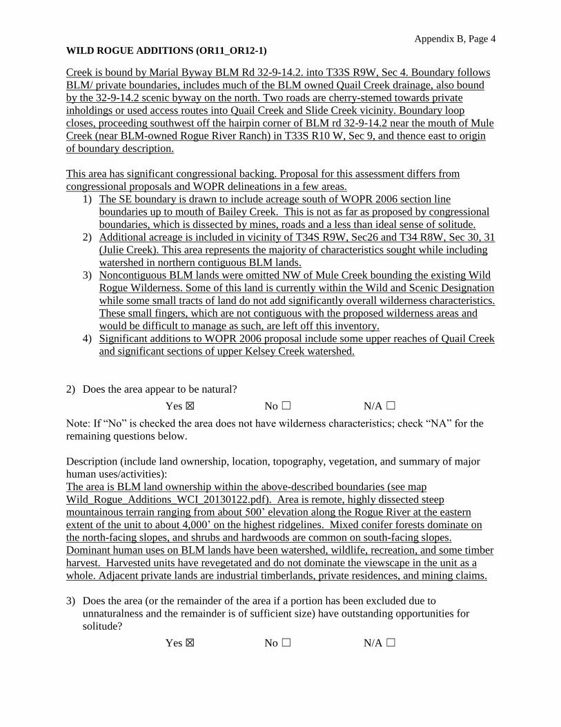
Appendix B, Page 4
WILD ROGUE ADDITIONS (OR11_OR12-1)
Creek is bound by Marial Byway BLM Rd 32-9-14.2. into T33S R9W, Sec 4. Boundary follows
BLM/ private boundaries, includes much of the BLM owned Quail Creek drainage, also bound
by the 32-9-14.2 scenic byway on the north. Two roads are cherry-stemed towards private
inholdings or used access routes into Quail Creek and Slide Creek vicinity. Boundary loop
closes, proceeding southwest off the hairpin corner of BLM rd 32-9-14.2 near the mouth of Mule
Creek (near BLM-owned Rogue River Ranch) in T33S R10 W, Sec 9, and thence east to origin
of boundary description.
This area has significant congressional backing. Proposal for this assessment differs from
congressional proposals and WOPR delineations in a few areas.
1) The SE boundary is drawn to include acreage south of WOPR 2006 section line
boundaries up to mouth of Bailey Creek. This is not as far as proposed by congressional
boundaries, which is dissected by mines, roads and a less than ideal sense of solitude.
2) Additional acreage is included in vicinity of T34S R9W, Sec26 and T34 R8W, Sec 30, 31
(Julie Creek). This area represents the majority of characteristics sought while including
watershed in northern contiguous BLM lands.
3) Noncontiguous BLM lands were omitted NW of Mule Creek bounding the existing Wild
Rogue Wilderness. Some of this land is currently within the Wild and Scenic Designation
while some small tracts of land do not add significantly overall wilderness characteristics.
These small fingers, which are not contiguous with the proposed wilderness areas and
would be difficult to manage as such, are left off this inventory.
4) Significant additions to WOPR 2006 proposal include some upper reaches of Quail Creek
and significant sections of upper Kelsey Creek watershed.
2) Does the area appear to be natural?
Yes ☒ No ☐ N/A ☐
Note: If “No” is checked the area does not have wilderness characteristics; check “NA” for the
remaining questions below.
Description (include land ownership, location, topography, vegetation, and summary of major
human uses/activities):
The area is BLM land ownership within the above-described boundaries (see map
Wild_Rogue_Additions_WCI_20130122.pdf). Area is remote, highly dissected steep
mountainous terrain ranging from about 500’ elevation along the Rogue River at the eastern
extent of the unit to about 4,000’ on the highest ridgelines. Mixed conifer forests dominate on
the north-facing slopes, and shrubs and hardwoods are common on south-facing slopes.
Dominant human uses on BLM lands have been watershed, wildlife, recreation, and some timber
harvest. Harvested units have revegetated and do not dominate the viewscape in the unit as a
whole. Adjacent private lands are industrial timberlands, private residences, and mining claims.
3) Does the area (or the remainder of the area if a portion has been excluded due to
unnaturalness and the remainder is of sufficient size) have outstanding opportunities for
solitude?
Yes ☒ No ☐ N/A ☐
Appendix B, Page 5
WILD ROGUE ADDITIONS (OR11_OR12-1)
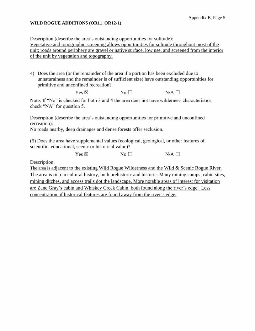
Description (describe the area’s outstanding opportunities for solitude):
Vegetative and topographic screening allows opportunities for solitude throughout most of the
unit; roads around periphery are gravel or native surface, low use, and screened from the interior
of the unit by vegetation and topography.
4) Does the area (or the remainder of the area if a portion has been excluded due to
unnaturalness and the remainder is of sufficient size) have outstanding opportunities for
primitive and unconfined recreation?
Yes ☒ No ☐ N/A ☐
Note: If “No” is checked for both 3 and 4 the area does not have wilderness characteristics;
check “NA” for question 5.
Description (describe the area’s outstanding opportunities for primitive and unconfined
recreation):
No roads nearby, deep drainages and dense forests offer seclusion.
(5) Does the area have supplemental values (ecological, geological, or other features of
scientific, educational, scenic or historical value)?
Yes ☒ No ☐ N/A ☐
Description:
The area is adjacent to the existing Wild Rogue Wilderness and the Wild & Scenic Rogue River.
The area is rich in cultural history, both prehistoric and historic. Many mining camps, cabin sites,
mining ditches, and access trails dot the landscape. More notable areas of interest for visitation
are Zane Gray’s cabin and Whiskey Creek Cabin, both found along the river’s edge. Less
concentration of historical features are found away from the river’s edge.
Appendix B, Page 6
WILD ROGUE ADDITIONS (OR11_OR12-1)
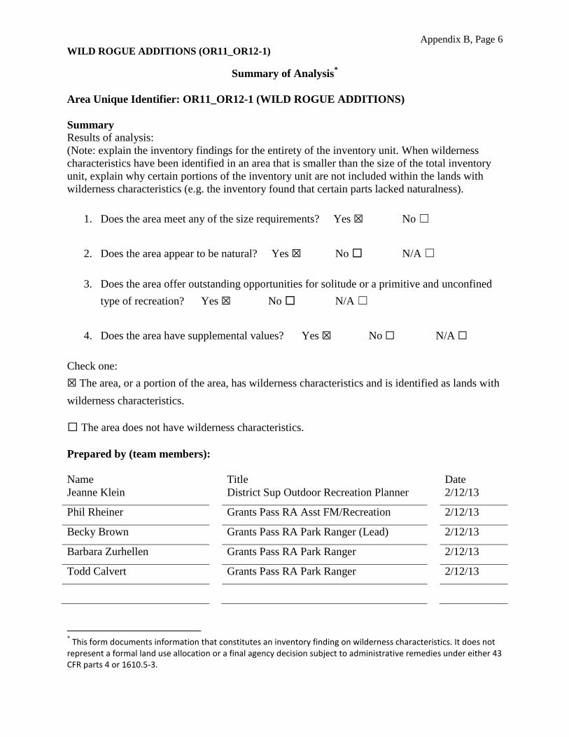
Summary of Analysis *
Area Unique Identifier: OR11_OR12-1 (WILD ROGUE ADDITIONS)
Summary
Results of analysis:
(Note: explain the inventory findings for the entirety of the inventory unit. When wilderness
characteristics have been identified in an area that is smaller than the size of the total inventory
unit, explain why certain portions of the inventory unit are not included within the lands with
wilderness characteristics (e.g. the inventory found that certain parts lacked naturalness).
1. Does the area meet any of the size requirements? Yes ☒ No ☐
2. Does the area appear to be natural? Yes ☒ No ☐ N/A ☐
3. Does the area offer outstanding opportunities for solitude or a primitive and unconfined
type of recreation? Yes ☒ No ☐ N/A ☐
4. Does the area have supplemental values? Yes ☒ No ☐ N/A ☐
Check one:
☒ The area, or a portion of the area, has wilderness characteristics and is identified as lands with
wilderness characteristics.
☐ The area does not have wilderness characteristics.
Prepared by (team members):
Name Title Date
Jeanne Klein District Sup Outdoor Recreation Planner 2/12/13
Phil Rheiner Grants Pass RA Asst FM/Recreation 2/12/13
Becky Brown Grants Pass RA Park Ranger (Lead) 2/12/13
Barbara Zurhellen Grants Pass RA Park Ranger 2/12/13
Todd Calvert Grants Pass RA Park Ranger 2/12/13
* This form documents information that constitutes an inventory finding on wilderness characteristics. It does not
represent a formal land use allocation or a final agency decision subject to administrative remedies under either 43 CFR parts 4 or 1610.5-3.

Appendix B, Page 7 WILD ROGUE ADDITIONS (0Rll_OR12-1)
Reviewed by (District or Field Manager):
/:?S·--Nall(e Title
Aile~ Bollschweiler
!J#KX. see <·

17 16
Wilderness Characteristics Inventory - Wild Rogue Additions (OR11_12-11) WORKING DRAFT 2013/01/23 15 14 13 18 17 16 15 14 13 18 17 16 15 14 13 18 17
19 20 21 22 23 24 19 20 21 22 23 24 20 23 24 19 2219 21 22 20 21 23 24 19 20KELSEY NORTH
30 29 28 27 26 25 30 29 28 27
31 32 33 34 35 36 31 32 33 34 35 36 31 32 33 34 35 36 31 32 33 34 31 3235 36
!. 26 25 30 29 28 27 26 25 30 29 28 27 26 25 30 29MARBLE GAP
!.
09 1108 12 07 08 09 10 11 12 07 08 09
!. 05 04 03 02 01 06 05 04 03 02 01 06 05 04KELSEY PEAK
03069 02 01 06 05
!"/.MT RUBEN 04 03 02 01 06 05
10
15 14 13
Wh skey Creek18 068 6179 Acres
18 067 15 14 !.
""//
10 12 07 08 09 10 11 12 07 08i
11 MT RUBEN RD
17 16 15 14 13 17 16 13 18 17 16 15 14 13 18 17
20 21 22 23 24 19 20 21 22
23 24 19 20 065 072
26 25 30 2929 28 27 26 25 30 29 28 27 Wi d Rogue Add51249 Acres
ons
22 2321 RUSSIAN WHISRUSS!!..
"/ "/
24 19 20 21 24 19 2022 23
IAN WH B
l iti 28 27 26 25 30 29 28 27 26 25 30 29
33 3432 33 34 35 36 31 32 33 34 35 36 31 32 36 31 32 33 34 35 36 31 3235
05 04 03 02 01 06 05 04 03 02 05 04 03 06 05 04 03 02 01 06 0501 02 0106
08 09 10 11 12 07 08 09 10 11 12 07 08 09 10 11 12 07 08 09 10 11 12 07 08
1417 16 15 14 13 18 17 16 15 14 13 18 17 16 15 13 18 17 16 15 14 13 18 17 18
20 21 22 23 24 19 20 21 22 23 24 19 20 21 22 23 24 19 20 21 23 24 19 2022
29 28 27 26 25 30 29 28 27 26 25 30 29 28 27 26 25 30 29 28 27 26 25 30 29
3532 33 34 35 36 31 32 33 34 35 36 31 32 33 34 36 31 32 33 34 35 36 31 32
05 04 03 02 01 06 05 04 03 02 01 06 05 04 03 02 05 04 03 02 01 06 05060108 09 10 11 12 07 08 09 10 11 12 07 08 09 10 11 08
Wild_Rogue_Photo_Pts
Quarries
RoadOwnerDesg
Bureau of Land Management County route Forest Service Other state route Municipal route (urban, residential, etc.)Private road (no symbol)Not Known WCI Units 2013 WCI Unit bgTrails Section
OwnershipPROPERTY STATUS
Bureau of Indian Affairs Bureau of Land Management U.S. Forest Service Bureau of Reclamation
"/
!.
Corps of Engineers National Park ServiceNo warranty is made by the Bureau of Land Management as to the accuracy, U.S. Fish and Wildlife Servicereliability, or completeness of these data for individual or aggregate use Local Governmentwith other data. Original data were compiled from various sources and may State
be updated without notification. Miles Private Individual or CompanyUndetermined
MXD: W:\ArcMap\WCI_BND_EDITS_20130120_LS.mxd AMP 0 1.25 2.5 5 ®
WILD ROGUE ADDITIONS ROUTE ANALYSIS 33-8-7.1 (Meadow Cr Spur)
WILDERNESS CHARACTERISTICS INVENTORY
APPENDIX C – ROUTE ANALYSIS1
(Factors to consider when determining whether a route is a road2 for wilderness characteristics inventory
purposes.)
Wilderness Characteristics Inventory Area Unique Identifier: OR11-OR12 1
(Wild Rogue Additions)
Route or Route Segment3 Name and/or Identifier: 33-8-7.1 (Meadow Cr Spur)
(Include Transportation Plan Identifier, if known, and include route number supplied by citizen
information, when available.)
I. LOCATION: Refer to attached map Wild_Rogue_Additions_RouteAnalysis_20130124.pdf
and BLM corporate data (GIS). List photo point references (where applicable) or reference
attached photo log:
See attached photos and gps locations.
N0443267 E4728218
Describe:
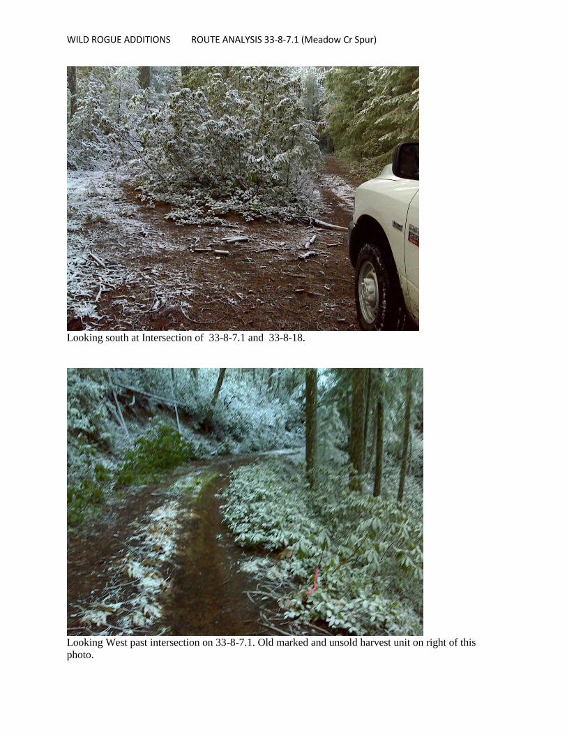
33-8-7.1 takes off to the south from boundary road 32-7-19.3 (Dutch Henry) in the NE ¼
Section 7 T33S R08W. Proceeds west and then south along the ridge between Coppsey
Creek and an unnamed tributary to Bunker Creek. Terminates at a rocky peak at the
headwaters of Francis Creek.
II. ROUTE CONTEXT
1 This form documents information that constitutes an inventory finding on wilderness characteristics. It does not
represent a formal land use allocation or a final agency decision subject to administrative remedies under either 43 CFR parts 4 or 1610.5-3. 2
Road: An access route which has been improved and maintained by mechanical means to insure relatively regular and continuous use. A way maintained solely by the passage of vehicles does not constitute a road.
If a portion of a route is found to meet the wilderness inventory road criteria (see Part III) and the remainder
a. Improved and maintained – Actions taken physically by people to keep the road open to vehicle traffic. “Improved” does not necessarily mean formal construction. “Maintained” does not necessarily mean annual maintenance.
b. Mechanical means – Use of hand or power machinery or tools. c. Relatively regular and continuous use – Vehicular use that has occurred and will continue to occur on a
relatively regular basis. Examples are: access roads for equipment to maintain a stock water tank or other established water sources, access roads to maintained recreation sites or facilities, or access roads to mining claims.
does not meet these criteria (e.g., a cherrystem road with a primitive route continuing beyond a certain point), identify each segment and explain the rationale for the separate findings under pertinent criteria.
3
WILD ROGUE ADDITIONS ROUTE ANALYSIS 33-8-7.1 (Meadow Cr Spur)
A. Current Purpose4 (if any) of Route: (Examples: Rangeland/Livestock Improvements (stock
tank, developed spring, reservoir, fence, corral), Inholdings (ranch, farmhouse), Mine Site,
Concentrated Use Site (camp site), Recreation, Utilities (transmission line, telephone,
pipeline), Administrative (project maintenance, communication site, vegetation treatment)).
Describe: Used for recreation and administrative purposes.
B. Right-of-Way (ROW):
1. Is there a ROW associated with this route?
Yes ☐ No ☐ Unknown ☒
2. If yes, what is the stated purpose of the ROW?
3. Is the ROW still being used for this purpose?
Yes ☐ No ☐ Unknown or N/A ☒
Explain:
III. WILDERNESS INVENTORY ROAD CRITERIA
A. Evidence of construction or improvement using mechanical means:
Yes ☒ (if either A.1 or A.2 is checked “yes” below) No ☐ (if both A.1 and A.2 are
checked “no” below)
1. Construction: (Is there evidence that the route or route segment was originally
constructed using mechanical means?) Yes ☒ No ☐
Examples: Paved☐ Bladed☐ Graveled☒ Roadside Berms☐ Cut/Fill☒ Other☐
Describe: partially graveled in past, partially natural road bed surface.
2. Improvements: (Is there evidence of improvements using mechanical means to facilitate
access?) Yes ☐ No ☒ If “yes”: by Hand Tools ☐ by Machine ☐
Examples: Culverts☐ Hardened Stream Crossings☐ Bridges☐ Drainage☐ Barriers☐ Other
☐ Describe: 33-8-7.1 from unit boundary in to junction of 33-8-18 had rock surface at one time. Best
portion of road, which has had little or no use recently. Brush rapidly growing in from sides,
4 The purpose of a route is not a deciding factor in determining whether a route is a road for wilderness
characteristics inventory purposes. The purpose of a route does provide context for factors on which such a determination may be based, particularly the question of whether maintenance of the route ensures relatively regular and continuous use. The purpose also helps to determine whether maintenance that may so far have been unnecessary to ensure such use would be approved by BLM when the need arises.

WILD ROGUE ADDITIONS ROUTE ANALYSIS 33-8-7.1 (Meadow Cr Spur)
minimizing road clearance. Road condition diminishes to natural surface, narrow passage with
growth in road bed and shoulders. Probably becoming impassable in next 5-10 years without use or
maintenance. No recent maintenance evident from past 10 years or so.
B. Maintenance: (Is there evidence of maintenance that would ensure relatively regular and
continuous use?):
Yes ☐ (if either B.1 or B.2 is checked “yes” below) No ☒ (if both B.1 and B.2 are checked
“no” below)
1. Is there Evidence or Documentation of Maintenance using hand tools or machinery?
Yes ☐ No ☒ If “yes”: by Hand Tools ☐ by Machine ☐
Explain: None
2. If the route or route segment is in good5 condition, but there is no evidence of
maintenance, would mechanical maintenance with hand tools or machines be approved
by BLM to meet the purpose(s) of the route in the event this route became impassable?
Yes ☐ No ☒
Explain: Unlikely that activites in this area would warrant this road maintenance.
C. Relatively regular and continuous use: (Does the route or route segment ensure relatively
regular and continuous use?) Yes ☐ No ☒
Describe evidence (e.g., direct, vehicles or vehicle tracks observed, or indirect, evidence of use
associated with purpose of the route such as maintenance of facility that route accesses) and
other rationale for whether use has occurred and will continue to occur on a relatively regular
basis (i.e., regular and continuous use relative to the purpose(s) of the route): 6
No travel evident at all.
IV. CONCLUSION:
Does the route or route segment7 meet the definition of a wilderness inventory road (i.e., are items
III.A and III.B and III.C all checked yes)?
5 Good condition would be a condition that ensures regular and continuous use relative to the purposes of the
route. Consider whether the route can be clearly followed in the field over its entire course and whether all or any portion of the route contains any impediments to travel. 6
Include estimate of travel rates for the stated purposes, e.g., trips/day or week or month or season or year or even multiple years in some facility maintenance cases. 7
If part of the route meets the wilderness inventory road definition and the remainder does not, describe the segment meeting the definition and any remaining portion not meeting the definition and why.

WILD ROGUE ADDITIONS ROUTE ANALYSIS 33-8-7.1 (Meadow Cr Spur)
Yes ☐ = Wilderness Inventory Road No ☒ = Not a road for wilderness inventory purposes
Explanation8: Road exhibits little to no recent use within last 5 to 10 years. It has no apparent
destination. No old timber units or management activities are apparent. There are some old proposed
harvest units near the intersection described above, no harvest action is underway currently.
Evaluator(s)
Todd Calvert
Date
12-13-12
Becky Brown 12-13-12
8 Describe and explain rationale for any discrepancies with citizen proposals.
WILD ROGUE ADDITIONS ROUTE ANALYSIS 33-8-7.1 (Meadow Cr Spur)
Looking south at Intersection of 33-8-7.1 and 33-8-18.
Looking West past intersection on 33-8-7.1. Old marked and unsold harvest unit on right of this
photo.

WILD ROGUE ADDITION Route Analysis 33-8-17.1 ridge extension
WILDERNESS CHARACTERISTICS INVENTORY
APPENDIX C – ROUTE ANALYSIS1
(Factors to consider when determining whether a route is a road2 for wilderness characteristics inventory
purposes.)
Wilderness Characteristics Inventory Area Unique Identifier: OR11-OR12 - 1
Route or Route Segment3 Name and/or Identifier: 33-8-17.1 ridge extension between Bunker and
Bronco Creeks. Sections 20, 30 and 36.
(Include Transportation Plan Identifier, if known, and include route number supplied by citizen
information, when available.)
I. LOCATION: Refer to attached map Wild_Rogue_Additions_Route_Analysis_20130124.pdf
and BLM corporate data (GIS). List photo point references (where applicable) or reference
attached photo log:
See attached photo #065. Location: UTM N0445137 E4726090
Describe: See attached photo and descriptions
II. ROUTE CONTEXT
Native surface spur off 38-8-17.1 that runs approximately 2-2.5 miles along ridge between
Russian and Bunker Creeks.
1 This form documents information that constitutes an inventory finding on wilderness characteristics. It does not
represent a formal land use allocation or a final agency decision subject to administrative remedies under either 43 CFR parts 4 or 1610.5-3. 2
Road: An access route which has been improved and maintained by mechanical means to insure relatively regular and continuous use. A way maintained solely by the passage of vehicles does not constitute a road.
If a portion of a route is found to meet the wilderness inventory road criteria (see Part III) and the remainder
a. Improved and maintained – Actions taken physically by people to keep the road open to vehicle traffic. “Improved” does not necessarily mean formal construction. “Maintained” does not necessarily mean annual maintenance.
b. Mechanical means – Use of hand or power machinery or tools. c. Relatively regular and continuous use – Vehicular use that has occurred and will continue to occur on a
relatively regular basis. Examples are: access roads for equipment to maintain a stock water tank or other established water sources, access roads to maintained recreation sites or facilities, or access roads to mining claims.
does not meet these criteria (e.g., a cherrystem road with a primitive route continuing beyond a certain point), identify each segment and explain the rationale for the separate findings under pertinent criteria.
3
WILD ROGUE ADDITION Route Analysis 33-8-17.1 ridge extension
A. Current Purpose4 (if any) of Route: (Examples: Rangeland/Livestock Improvements (stock
tank, developed spring, reservoir, fence, corral), Inholdings (ranch, farmhouse), Mine Site,
Concentrated Use Site (camp site), Recreation, Utilities (transmission line, telephone,
pipeline), Administrative (project maintenance, communication site, vegetation treatment)).
Describe: None noted, unused for 20 yrs approx. Vegetation is growing in rapidly.
B. Right-of-Way (ROW):
1. Is there a ROW associated with this route?
Yes ☐ No ☐ Unknown ☒
2. If yes, what is the stated purpose of the ROW?
3. Is the ROW still being used for this purpose?
Yes ☐ No ☐ Unknown or N/A ☒
Explain:
III. WILDERNESS INVENTORY ROAD CRITERIA
A. Evidence of construction or improvement using mechanical means:
Yes ☒ (if either A.1 or A.2 is checked “yes” below) No ☐ (if both A.1 and A.2 are
checked “no” below)
1. Construction: (Is there evidence that the route or route segment was originally
constructed using mechanical means?) Yes ☒ No ☐
Examples: Paved☐ Bladed☐ Graveled☐ Roadside Berms☐ Cut/Fill☒ Other☐
Describe: single track punched in with cat.
2. Improvements: (Is there evidence of improvements using mechanical means to facilitate
access?) Yes ☐ No ☒ If “yes”: by Hand Tools ☐ by Machine ☐
Examples: Culverts☐ Hardened Stream Crossings☐ Bridges☐ Drainage☐ Barriers☐ Other
☐ Describe: None noted, ridgetop location.
4 The purpose of a route is not a deciding factor in determining whether a route is a road for wilderness
characteristics inventory purposes. The purpose of a route does provide context for factors on which such a determination may be based, particularly the question of whether maintenance of the route ensures relatively regular and continuous use. The purpose also helps to determine whether maintenance that may so far have been unnecessary to ensure such use would be approved by BLM when the need arises.

WILD ROGUE ADDITION Route Analysis 33-8-17.1 ridge extension
B. Maintenance: (Is there evidence of maintenance that would ensure relatively regular and
continuous use?):
Yes ☐ (if either B.1 or B.2 is checked “yes” below) No ☒ (if both B.1 and B.2 are checked
“no” below)
1. Is there Evidence or Documentation of Maintenance using hand tools or machinery?
Yes ☐ No ☒ If “yes”: by Hand Tools ☐ by Machine ☐
Explain: No maintenance or use for a long, long time.
2. If the route or route segment is in good5 condition, but there is no evidence of
maintenance, would mechanical maintenance with hand tools or machines be approved
by BLM to meet the purpose(s) of the route in the event this route became impassable?
Yes ☐ No ☒
Explain: No proposed activities in this area.
C. Relatively regular and continuous use: (Does the route or route segment ensure relatively
regular and continuous use?) Yes ☐ No ☒
Describe evidence (e.g., direct, vehicles or vehicle tracks observed, or indirect, evidence of use
associated with purpose of the route such as maintenance of facility that route accesses) and
other rationale for whether use has occurred and will continue to occur on a relatively regular
basis (i.e., regular and continuous use relative to the purpose(s) of the route): 6
Activities present to the WCI unit boundary, ex: brushing, unit thinning. Road to this point was
brushed on one side, providing access. This road had gravel surface up to boundary, past
boundary was natural surface, grown in, unused and unmaintained in any way.
IV. CONCLUSION:
Does the route or route segment7 meet the definition of a wilderness inventory road (i.e., are items
III.A and III.B and III.C all checked yes)?
Yes ☐ = Wilderness Inventory Road No ☒ = Not a road for wilderness inventory purposes
5 Good condition would be a condition that ensures regular and continuous use relative to the purposes of the
route. Consider whether the route can be clearly followed in the field over its entire course and whether all or any portion of the route contains any impediments to travel. 6
Include estimate of travel rates for the stated purposes, e.g., trips/day or week or month or season or year or even multiple years in some facility maintenance cases. 7
If part of the route meets the wilderness inventory road definition and the remainder does not, describe the segment meeting the definition and any remaining portion not meeting the definition and why.

WILD ROGUE ADDITION Route Analysis 33-8-17.1 ridge extension
Explanation8: No apparent use within boundary, blends in with surroundings, is rapidly
naturalizing.
Evaluator(s) Date
Todd Calvert 12-13-12
Becky Brown 12-13-12
8 Describe and explain rationale for any discrepancies with citizen proposals.
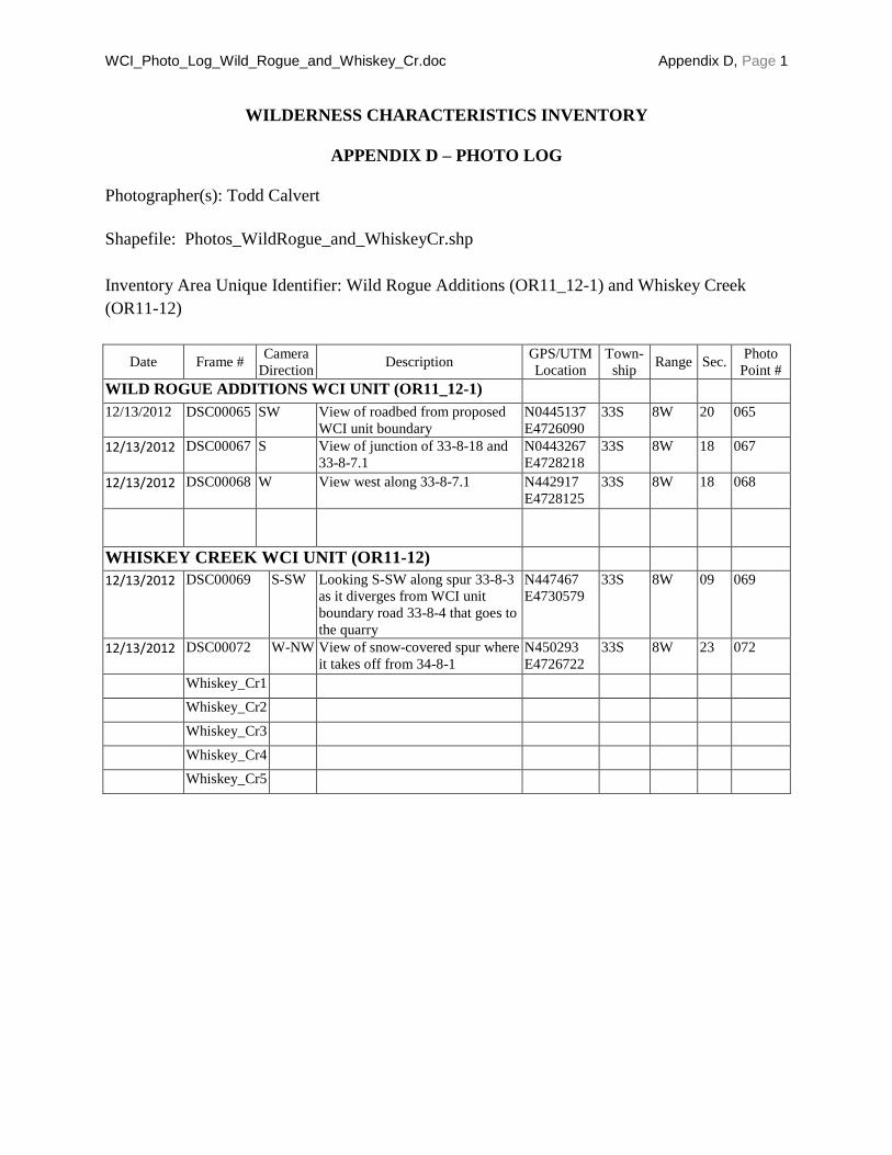
WCI_Photo_Log_Wild_Rogue_and_Whiskey_Cr.doc Appendix D, Page 1
WILDERNESS CHARACTERISTICS INVENTORY
APPENDIX D – PHOTO LOG
Photographer(s): Todd Calvert
Shapefile: Photos_WildRogue_and_WhiskeyCr.shp
Inventory Area Unique Identifier: Wild Rogue Additions (OR11_12-1) and Whiskey Creek
(OR11-12)
Date Frame # Camera
Direction Description
GPS/UTM
Location
Town-
ship Range Sec.
Photo
Point #
WILD ROGUE ADDITIONS WCI UNIT (OR11_12-1)
12/13/2012 DSC00065 SW View of roadbed from proposed
WCI unit boundary
N0445137
E4726090
33S 8W 20 065
12/13/2012 DSC00067 S View of junction of 33-8-18 and
33-8-7.1
N0443267
E4728218
33S 8W 18 067
12/13/2012 DSC00068 W View west along 33-8-7.1 N442917
E4728125
33S 8W 18 068
WHISKEY CREEK WCI UNIT (OR11-12)
12/13/2012 DSC00069 S-SW Looking S-SW along spur 33-8-3
as it diverges from WCI unit
boundary road 33-8-4 that goes to
the quarry
N447467
E4730579
33S 8W 09 069
12/13/2012 DSC00072 W-NW View of snow-covered spur where
it takes off from 34-8-1
N450293
E4726722
33S 8W 23 072
Whiskey_Cr1
Whiskey_Cr2
Whiskey_Cr3
Whiskey_Cr4
Whiskey_Cr5

DSC00065

DSC00067
DSC00068