wildfire situation update
TRANSCRIPT

Weather Summary:
Friday, July 23, 2021
1000 hrs.
Mary Butwin – NWS Seattle
Today/Tonight:
Conditions overall will remain very dry for the east side with humidity generally running around
10-20%, particularly for the southerly facing slopes. Many lower inland elevations west of the
Cascades are seeing humidity into the 30-40% range as little marine air made it inland last night.
Breezy conditions are expected on the east side of the Cascades, particularly through the north
central region, as a very weak front moves through the area. Generally weak instability on the
East side of the state with mixing heights 5-10k feet.
Winds generally ease overnight. Good to excellent humidity recovery expected for the west
side while generally moderate recovery conditions will set up on the east side tonight. The higher
terrain in the Blue and Selkirk Mountains.
Please refer to local NWS warnings and forecasts for specific details. *More information below*
Burn Restrictions/Announcements:
July 22, 2021: Fire Danger Ratings, Industrial Fire Precaution Levels Rise in Eastern WA
The Washington State Department of Natural Resources (DNR) and its partners are increasing Fire Danger Ratings (FDRs) and Industrial Fire Precaution Levels (IFPLs) on DNR-protected lands in parts of eastern Washington. Effective 12:01 a.m., Friday, July 23:
Fire danger will increase from Very High to Extreme in the Chelan, Foothills, Highlands, Kaniksu,
Lower Yakima, Methow, Upper Yakima and Valley FDRAs.
Industrial Fire Precaution Level (IFPL) will increase from Level 2 to Level 3 in zone: 680.
Read the full announcement here.
Wildfire Situation Update Date: July 23, 2021
For DNR’s current fire situation
status please visit:
http://fireinfo.dnr.wa.gov/
NW Preparedness Level: 5
National Preparedness Level: 5
NW T2 IMT Rotation: NW Team 6
(Sheldon)
DNR IA Activity: Light

July 20, 2021: DNR Closes Eastern WA Lands to Recreation Due to Extreme Fire Danger
This temporary closure will apply to DNR-managed state lands, conservation areas, community forests and
any associated roads, trails, campgrounds, recreational sites or recreational facilities. The decision to close
recreation and all public access on DNR-managed lands east of the Cascades is in addition to the burn ban
that Commissioner Franz enacted earlier this month on the 13 million acres of forestlands under DNR fire
protection. The burn ban will remain in effect through at least September 30. Campfires also remain
banned on DNR-managed lands statewide due to ongoing fire danger.
Read the full announcement here.
July 18, 2021: Colville Tribes Closes Reservation Due to Uncontrolled Fires
July 16, 2021: Umatilla National Forest lands temporarily closed
July 6, 2021: Inslee declares wildfire state of emergency, limited burn ban
Gov. Jay Inslee today declared a statewide state of emergency relating to the growing risk of wildfires,
including a statewide prohibition on most outdoor and agricultural burning through September 30, 2021.
Although this order includes some burn ban exceptions (for example, the use of gas-fueled stoves in some
circumstances and also small, recreational campfires in contained structures on a person’s private
property) nothing in the order supersedes more restrictive provisions by a lawful authority, like city or
county governments. The proclamation also activates the Washington National Guard to assist in wildfire
suppression efforts. Read the full proclamation here.
JULY 1, 2021: Commissioner Franz Enacts Statewide DNR Burn Ban
Prompted by increased fire danger due to prolonged drought, Fourth of July fireworks, increased
temperatures and winds, the order bans all outdoor burning on all forest lands under DNR fire protection,
including campfires.
Additional information:
Residents who see smoke should call 911 to report the fire. For tips on how to stay safe during fire
season, go to https://www.dnr.wa.gov/WildfirePrevention.
Wildfire statistics can be found on DNR’s Fire Dashboard at http://fireinfo.dnr.wa.gov/.
The signed statewide burn ban order can be seen here.
Residents can find their Fire Danger Rating Area at https://fortress.wa.gov/dnr/protection/firedanger/
and burn restrictions at https://burnportal.dnr.wa.gov/

Region Reports: Note that count of new IA fires and acres is now daily Monday-Friday, with
weekend activity included on Mondays. Large Fires are defined as 100 acres in timber or 300 acres in grass.
Northeast
New Fires 5 IA fires for 164.8 acres.
Resources Available
In Region Avail for Out of Region Engines 26 Engines 0
Crews 2 Crews 0
Notes: 7 active large fires. IMT3 and resources prepositioned for Nk’Mip available as surge resource. 5 dozers on standby.
Northwest
New Fires 1 IA fire for 0.5 acre.
Resources Available
In Region Avail for Out of Region
Engines 4 Engines 1 Crews - Crews -
Notes: 1 HEQB and 1 FFT1 available for out-of-region.
Olympic
New Fires 1 IA fire for 0.25 acre.
Resources Available
In Region Avail for Out of Region
Engines 4 Engines 0 Crews 3 Crews 0
Notes: Mechanic and HEQBt available.
Pacific Cascade
New Fires 2 IA fires for 0.75 acre.
Resources Available
In Region Avail for Out of Region Engines 10 Engines 3
Crews 2 Crews 0 Notes:

Southeast
New Fires 0 IA fires.
Resources Available
In Region Avail for Out of Region
Engines 29 Engines 0 Crews 1 Crews 0
Notes: 3 active large fires in region. 5 dozers on standby. Estes strike team in Wenatchee, NC/KY strike team in Dayton, 1 NW engine in Yakima. Ahtanum crew on short-term lend/lease to Chuweah. SE IMT3 Team 1 mobilizing to Steptoe Canyon, Team 2 mobilizing to Northrup. Critical needs: two ICT4/TFLDs, fire investigator, HEQB, ENGB.
South Puget New Fires 0 IA fires.
Resources
Available
In Region Avail for Out of Region
Engines 7 Engines 0
Crews 3 Crews 0
Notes:
Recent Fire Activity Snapshot: See: http://fireinfo.dnr.wa.gov/

Large Fire Details: [see attachments for additional information where available]
Northrup. (BLM) 7 mi S of Grand Coulee, WA. Start 7/22. +300 acres. Grass and shrub. Road, trail, and area closures.
IMT3 mobilizing. More information to come.
Cedar Creek. (US Forest Service) WA-OWF-000320. IMT2, NW Team 8 (Stock). 5 mi SW of Mazama, WA. Start 7/8.
Full Suppression. Cause: Lightning. 18,634 acres (+3,777). 11% containment. Active fire behavior. Timber. Structures
threatened. Evacuations in effect. Road, trail and area closures. https://inciweb.nwcg.gov/incident/7655/
Delancy. (US Forest Service) WA-OWF-000349. IMT2, NW Team 8 (Stock). 4 mi W of Mazama, WA. Start 7/11. Full
Suppression. Cause: Lightning. 219 acres (+0). 0% containment. Active fire behavior. Timber. Road, trail and area
closures. https://inciweb.nwcg.gov/incident/7655/
Cub Creek 2. (NE Region DNR) WA-NES-000373. IMT1, CA Team 1 (McGowan). 5 mi N of Winthrop, WA. Start 7/16.
Full Suppression. Cause: Unknown. 38,671 acres (+3,537). 5% containment. Active fire behavior. Brush and timber.
Structures threatened. Evacuations in effect. Road, trail, and area closures. Transfer command to IMT1, CA Team 1
(McGowan) occurred today at 0600. https://inciweb.nwcg.gov/incident/7675/
Summit Trail. (Bureau of Indian Affairs) WA-COA-200087. IMT2, CA Team 10 (Dalrymple). 12 miles W of Inchelium,
WA. Start 7/13. Full Suppression. Cause: Lightning. 5,942 acres (+583). 0% containment. Active fire behavior. Timber.
Structures threatened. Evacuation notices. Road, trail and area closures. https://inciweb.nwcg.gov/incident/7677/
Chuweah Creek Fire. (Bureau of Indian Affairs) WA-COA-200084. IMT2, NW Team 12 (Dimke). 15 mi N of Grand
Coulee, WA. Start 7/12. Full Suppression. Cause: Lightning. 36,730 acres (+40). 45% containment. Brush and timber.
Active fire behavior. Structures threatened. Evacuation notices. Road and area
closures. https://inciweb.nwcg.gov/incident/7664/
Green Ridge. (US Forest Service) OR-UMF-000659. IMT1, PNW Team 3 (Johnson). 30 mi E of Walla Walla, WA. Start
7/7. Full Suppression. Cause: Lightning. 3,915 acres (+487). 15% containment. Active fire behavior. Timber.
Structures threatened. Evacuations notices. Road, trail and area closures. https://inciweb.nwcg.gov/incident/7628/
Lick Creek. (US Forest Service) OR-UMF-000658. IMT1, PNW Team 3 (Johnson). 2 mi SW of Asotin, WA. Start 7/7. Full
Suppression. Cause: Lightning. 73,528 acres (+0) 55% containment. Active fire behavior. Timber. Structures
threatened. Evacuation notices. Road, trail and area closures. IMT2, CA Team 12 (Nobles) mobilizing with date/time
needed tomorrow 7/24 at 1400. https://inciweb.nwcg.gov/incident/7615/
Goddard Road. (NE Region DNR) WA-NES-002076. IMT3. 2 mi N of Rice, WA. Start 7/16. Full Suppression. Cause:
Unknown. 784 acres (+0). 35% containment. Active fire behavior. Timber. Structures threatened. Evacuations in
effect. https://inciweb.nwcg.gov/incident/7676/
Steptoe. (Washington State Fire Marshal) WA-WFS-002129. IMT3. 5 mi SW of Colton, WA. Start 7/22. Full
Suppression. Cause: Lightning. 2,000 acres (+1,500). 0% containment. Active fire behavior. Grass and brush. Road
closure.
Sherwood. (Spokane Tribe) WA-SPA-002124. IMT3. 2 mi N of Wellpinit, WA. Start 7/21. Full Suppression. Cause:
Unknown. 375 acres. 30% containment. Active fire behavior. Timber. Structures threatened. Evacuations in effect.
NWCC Links: Morning Brief 7-Day Significant Fire Potential Situation Report

2021 WA DNR Wildfire Statistics as of 07/23/2021
ResponsesFires and false alarms on any jurisdiction where DNR dispatched resources
DNR Responses Response Acres
Eastside 941 150158.12
Westside 327 243.86
Total 1268 150401.98
DNR Protection FiresFires on or those threatening DNR-protected lands
DNR Fires DNR Acres
Eastside 548 106222.92
Westside 235 239.06
Totals 783 106461.98
Fire CausesNumber of DNR fires by general cause category
Fire LocationsNew fires shown in red (last 72hrs), older fires in black
Ten Year (Year-to-Date) Fire StatisticsThese values represent the total number of DNR fires and acres burned over the last ten years from January 1 to the date of this report. Note that the average is calculated
on 2011-2020 numbers to allow for editing/finalizing of 2021 statistics.
Report created from EIRS on: Fri Jul 23 06:01:21 2021
Data Disclaimer: Statistics for DNR Wildfire Reports are compiled in DNR's internal Emergency Incident Response Statistics (EIRS) software from the regionaldispatch offices. Statistics are subject to editing, and may vary throughout the season until finalized at the end of the year.
For questions about these statistics, please email [email protected].
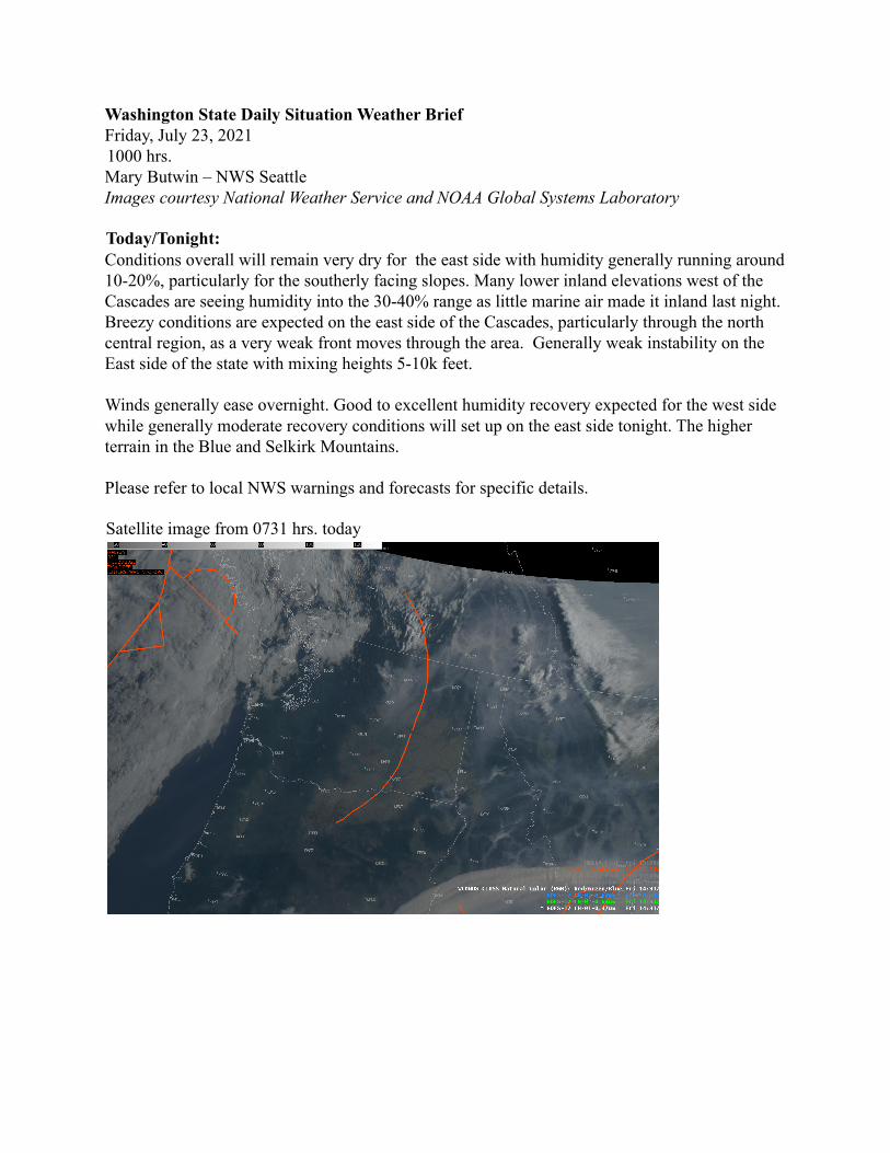
Washington State Daily Situation Weather BriefFriday, July 23, 20211000 hrs.Mary Butwin – NWS SeattleImages courtesy National Weather Service and NOAA Global Systems Laboratory
Today/Tonight:Conditions overall will remain very dry for the east side with humidity generally running around10-20%, particularly for the southerly facing slopes. Many lower inland elevations west of theCascades are seeing humidity into the 30-40% range as little marine air made it inland last night.Breezy conditions are expected on the east side of the Cascades, particularly through the northcentral region, as a very weak front moves through the area. Generally weak instability on theEast side of the state with mixing heights 5-10k feet.
Winds generally ease overnight. Good to excellent humidity recovery expected for the west sidewhile generally moderate recovery conditions will set up on the east side tonight. The higherterrain in the Blue and Selkirk Mountains.
Please refer to local NWS warnings and forecasts for specific details.
Satellite image from 0731 hrs. today
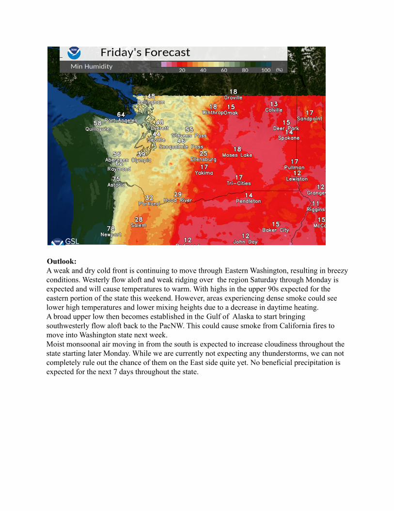
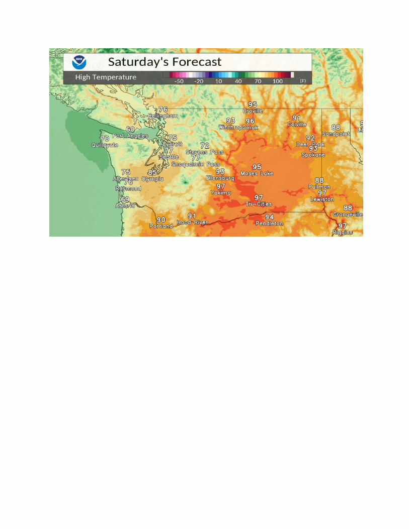
Outlook:A weak and dry cold front is continuing to move through Eastern Washington, resulting in breezyconditions. Westerly flow aloft and weak ridging over the region Saturday through Monday isexpected and will cause temperatures to warm. With highs in the upper 90s expected for theeastern portion of the state this weekend. However, areas experiencing dense smoke could seelower high temperatures and lower mixing heights due to a decrease in daytime heating.A broad upper low then becomes established in the Gulf of Alaska to start bringingsouthwesterly flow aloft back to the PacNW. This could cause smoke from California fires tomove into Washington state next week.Moist monsoonal air moving in from the south is expected to increase cloudiness throughout thestate starting later Monday. While we are currently not expecting any thunderstorms, we can notcompletely rule out the chance of them on the East side quite yet. No beneficial precipitation isexpected for the next 7 days throughout the state.

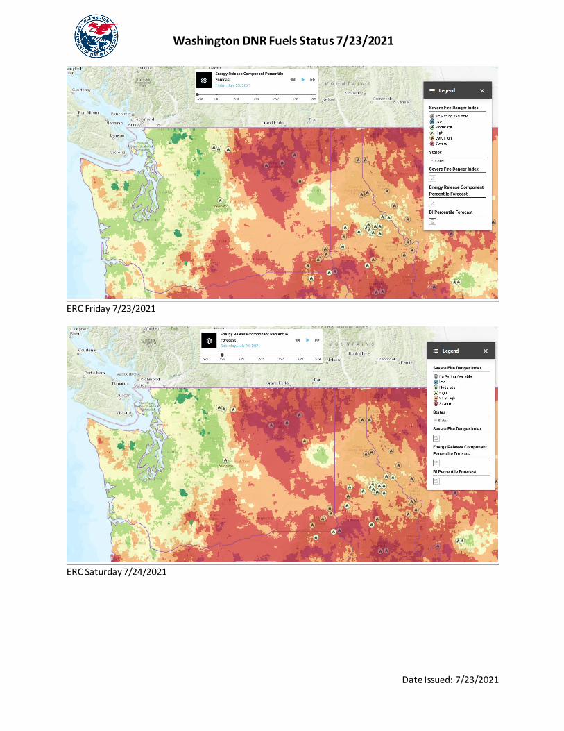
Washington DNR Fuels Status 7/23/2021
Date Issued: 7/23/2021
Vaughn Cork Fuels Analyst Narrative: The holdover threat from thunderstorms in the eastern counties should be essentially gone by this point. Connectivity issues with the GOES West satellite caused several RAWS stations to fail to report. Some westside indices were especially thrown off. The area of most concern over the weekend is the northern tier from the Methow valley to the Idaho border where fuel conditions are most severe. Eastern Washington – Todays cooler weather will help to decrease intensity a bit, and that should keep through Saturday. By Sunday with the heat and breeze back, we will see fire danger reverse and begin climbing again into the middle of next week. Fire activity can subsequently increase. Expect extreme fire behavior for any new start and plan tactics accordingly. Long range spotting up to and exceeding 1 mile has been reported, and transitioning from surface to canopy is common. Western Washington – Onshore flow is expected to continue through the middle of next week at least, keeping the large fire potential low overall. Low afternoon RH values from Olympia, down to the Oregon border will create more active fire along the southern I-5 corridor today. Those RH values look to moderate into the weekend decreasing that threat. Exposed sites can burn with high intensity and stumps and deep duff will pose mopup problems.
Severe Fire Danger Index with fires over 200 acres shown and VIIRS/MODIS hot spots. (wildfiresafe.technosylva.com)
Washington DNR Fuels Status 7/23/2021
Date Issued: 7/23/2021
ERC Friday 7/23/2021
ERC Saturday 7/24/2021

Washington DNR Fuels Status 7/23/2021
Date Issued: 7/23/2021
ERC Sunday 7/25/2021 Fuel Conditions by Fire Danger Rating Area:
FDRA Fire Danger ERC (±) BI (±) Live Fuel Avg (±) 100 hour(±) 1000 Hr(±) Methow EXTREME 98 (+1) 96 (-2) 80(-10) 8(-1)
Chelan EXTREME 95(+1) 95 (+3) 140(+50) 11(+1) Upper Yakima Very High 96(+1) 95(-3) 125(+5) 10(0) Lower Yakima High 89(0) 83(+5) 140(0) 12(0)
Valley EXTREME 100(+1) 97(+5) Dormant 9(0) Upper Basin EXTREME 100(0) 99(+6) Dormant 9(+1)
Lower Basin EXTREME 97(0) 88(+10) Dormant 9(0) Highlands EXTREME 100(0) 100(0) 90(0) 8(0)
Foothills EXTREME 96(+1) 100(0) 90(0) 12(-1) Kaniksu EXTREME 100(+2) 95(-2) 120(+10) 11(-1) Blue Mts EXTREME 62(0) 37(0) 93(0) 8.1(0)
Coast High 90(+3) 92(+3) 17(0) 19(0) Olympics Moderate 88(+5) 89(+10) 17(0) 17(0)
Cascade South Moderate 93(+4) 90(+1) 16(0) 17(0) Cascade Central High 96(+6) 97(+6) 16(-1) 17(0) Cascade North Moderate 88(0) 89(0) 18(0) 19(0)
Lowlands South High 96(+4) 96(+4) 16(-1) 17(0) Lowlands Central Moderate 83(0) 86(+20) 19(0) 19(+1)
Lowlands North Moderate 87(+2) 90(+5) 18(0) 18(0) **Note, indicated Adjective Fire Danger rating may not be the same as the publicly posted fire danger. Blue Mountains FDRA is part of a different FDOP and results are not posted in percentiles, all other ERC and BI values are in percentiles.
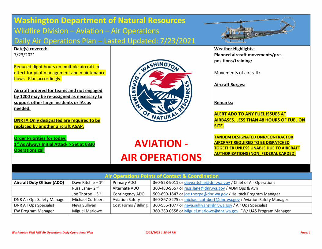
Washington DNR FIRE Air Operations Daily Operational Plan 7/23/2021 1:28:44 PM Page: 1
Washington Department of Natural Resources Wildfire Division – Aviation – Air Operations Daily Air Operations Plan – Lasted Updated: 7/23/2021
Date(s) covered: 7/23/2021 Reduced flight hours on multiple aircraft in effect for pilot management and maintenance flows. Plan accordingly. Aircraft ordered for teams and not engaged by 1200 may be re-assigned as necessary to support other large incidents or IAs as needed. DNR IA Only designated are required to be replaced by another aircraft ASAP. Order Priorities for today: 1st As Always Initial Attack > Set at 0830 Operations call
AVIATION - AIR OPERATIONS
Weather Highlights: Planned aircraft movements/pre-positions/training: Movements of aircraft: Aircraft Surges: Remarks:
ALERT ADO TO ANY FUEL ISSUES AT AIRBASES. LESS THAN 48 HOURS OF FUEL ON SITE. TANDEM DESIGNATED DNR/CONTRACTOR AIRCRAFT REQUIRED TO BE DISPATCHED TOGETHER UNLESS UNABLE DUE TO AIRCRAFT AUTHORIZATIONS (NON_FEDERAL CARDED)
Air Operations Points of Contact & Coordination Aircraft Duty Officer (ADO) Dave Ritchie – 1st Primary ADO 360-528-9011 or [email protected] / Chief of Air Operations
Russ Lane– 2nd Alternate ADO 360-480-9657 or [email protected] / ADM Ops & Avn
Joe Thorpe – 3rd Contingency ADO 509-899-1847 or [email protected] / Helitack Program Manager DNR Air Ops Safety Manager Michael Cuthbert Aviation Safety 360-867-3275 or [email protected] / Aviation Safety Manager
DNR Air Ops Specialist Neva Sullivan Cost Forms / Billing 360-556-1077 or [email protected] / Air Ops Specialist
FW Program Manager Miguel Marlowe 360-280-0558 or [email protected] FW/ UAS Program Manager
Washington DNR FIRE Air Operations Daily Operational Plan 7/23/2021 1:28:44 PM Page: 2
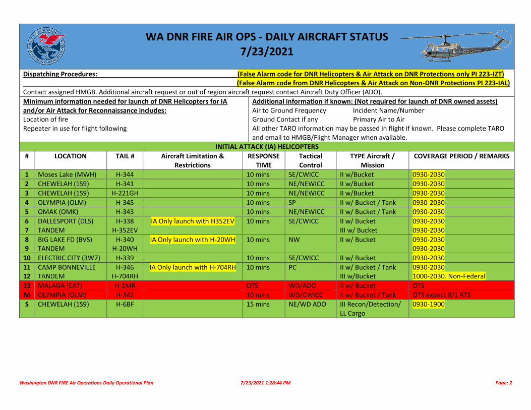
WA DNR FIRE AIR OPS - DAILY AIRCRAFT STATUS 7/23/2021
Dispatching Procedures: (False Alarm code for DNR Helicopters & Air Attack on DNR Protections only PI 223-IZT) (False Alarm code from DNR Helicopters & Air Attack on Non-DNR Protections PI 223-IAL) Contact assigned HMGB. Additional aircraft request or out of region aircraft request contact Aircraft Duty Officer (ADO).
Minimum information needed for launch of DNR Helicopters for IA and/or Air Attack for Reconnaissance includes: Location of fire Repeater in use for flight following
Additional information if known: (Not required for launch of DNR owned assets) Air to Ground Frequency Incident Name/Number Ground Contact if any Primary Air to Air All other TARO information may be passed in flight if known. Please complete TARO and email to HMGB/Flight Manager when available.
INITIAL ATTACK (IA) HELICOPTERS
# LOCATION TAIL # Aircraft Limitation & Restrictions
RESPONSE TIME
Tactical Control
TYPE Aircraft / Mission
COVERAGE PERIOD / REMARKS
1 Moses Lake (MWH) H-344 10 mins SE/CWICC II w/Bucket 0930-2030
2 CHEWELAH (1S9) H-341 10 mins NE/NEWICC II w/Bucket 0930-2030
3 CHEWELAH (1S9) H-221GH 10 mins NE/NEWICC II w/Bucket 0930-2030
4 OLYMPIA (OLM) H-345 10 mins SP II w/ Bucket / Tank 0930-2030 5 OMAK (OMK) H-343 10 mins NE/NEWICC II w/ Bucket / Tank 0930-2030
6 7
DALLESPORT (DLS) TANDEM
H-338 H-352EV
IA Only launch with H352EV 10 mins SE/CWICC II w/ Bucket III w/ Bucket
0930-2030 0930-2030
8 9
BIG LAKE FD (BVS) TANDEM
H-340 H-20WH
IA Only launch with H-20WH 10 mins NW II w/ Bucket 0930-2030 0930-2030
10 ELECTRIC CITY (3W7) H-339 10 mins SE/CWICC II w/ Bucket 0930-2030
11 12
CAMP BONNEVILLE TANDEM
H-346 H-704RH
IA Only launch with H-704RH 10 mins PC II w/ Bucket / Tank III w/Bucket
0930-2030 1000-2030. Non-Federal
13 MALAGA (EAT) H-1MR OTS WD/ADO II w/ Bucket OTS
M OLYMPIA (OLM) H-342 10 mins WD/CWICC II w/ Bucket / Tank OTS expect 8/1 RTS S CHEWELAH (1S9) H-6BF 15 mins NE/WD ADO III Recon/Detection/
LL Cargo 0930-1900

Washington DNR FIRE Air Operations Daily Operational Plan 7/23/2021 1:28:44 PM Page: 3
NON-INITIAL ATTACK HELICOPTERS – EU/CWN # LOCATION TAIL # Aircraft Limitation &
Restrictions RESPONSE
TIME Tactical Control TYPE Aircraft /
Mission COVERAGE PERIOD /
REMARKS
1 Deer Park (DEW) HB-0CB 15 mins NE/NEWICC KMAX K-1200 1000-2030
2 Electric City (3W7) HT-268 15 mins NE / SE UH-60A-Tanked 0900-2030 3 Electric City (3W7) H-874 15 mins NE / SE II w/Tank & Bucket 0900-2030
4 Moses Lake (MWH) HB-274TH 20 mins WD UH-60A+ Bucket 0900-2030
5 Pullman (PUW) HB-672MP Non-Federal. WD UH-60A+ Bucket 0900-2030
6 Wilbur (2S8) Boxcar 91 Summit Trail 30 mins WD/Mt Tolman CH-47F 1000-2000.
FIXED WING – AIR ATTACK /RECON – EU/CWN – INITIAL ATTACK
# LOCATION TAIL # / Callsign Aircraft Limitation & Restrictions
RESPONSE TIME
Tactical Control
TYPE Aircraft / Mission
COVERAGE PERIOD / REMARKS
1 YAKIMA (YKM) AA-10F / AA651 DNR ATGS Call in. Max 4 hours for extended attacks
15 minutes SE/CWICC Aero Commander 500 0900-2000
2 DEER PARK (DEW) AA-4TS / AA653 DNR ATGS Call in. Max 4 hours for extended attacks
15 minutes NE-NEWICC Aero Commander 500 0900-2000
3 OMAK (OMK) – BIA AA-4WA BIA 15 minutes NE-NEWICC Aero Commander 690B BIA
4 WENATCHEE (EAT) AA-1TB / AA617 Federal 15 minutes OWF/CWICC Aero Commander 690B USFS 5 OLYMPIA (OLM) N-357PN ADO TBD WD/ADO P-68 Partnavia Request through ADO/ADM-AO
6 OLYMPIA (OLM) AA-203KQ NO ATGS 15 Minutes WD Kodiak/Bridger 16 0900-2000
7 FAIRCHILD (SKA) COYOTE 99 AWAITING ASSIGNMENT 15 minutes WD UH-72 / LAKOTA 0830-1700
FIXED WING – SEATS – EU/CWN # LOCATION TAIL # Aircraft Limitation &
Restrictions RESPONSE
TIME Tactical Control
TYPE Aircraft / Mission
COVERAGE PERIOD / REMARKS
1 Yakima (YKM) FB-241 DNR. 4 hour limit for Extended Attack
15 minutes SE/CWICC Fireboss SEAT 0900-2030
2 Yakima (YKM) FB-205 DNR. 4 hour limit for Extended Attack
15 minutes SE/CWICC Fireboss SEAT 0900-2030
3 Omak (OMK) FB-244 DNR. 4 hour limit for Extended Attack
15 minutes NE/NEWICC Fireboss SEAT 0900-2030
4 Omak (OMK) FB-212 DNR. 4 hour limit for Extended Attack
15 minutes NE/NEWICC Fireboss SEAT 0900-2030
5 Omak (OMK) - BIA FB-216 BIA 15 minutes NE/NEWICC Fireboss SEAT 0900-2030
6 Deer Park (DEW) FB-201 DNR. 4 hours limit for Extended Attack
15 minutes NE/NEWICC Fireboss SEAT 0900-2030
7 Deer Park (DEW) – BIA FB-202 BIA 15 minutes NEWICC Fireboss SEAT 0900-2030

Washington DNR FIRE Air Operations Daily Operational Plan 7/23/2021 1:28:44 PM Page: 4
8 Deer Park (DEW) – BIA FB-217 BIA 15 minutes NEWICC Fireboss SEAT 0900-2030 9 Deer Park (DEW) – FED FB-243 FED 15 minutes NEWICC Fireboss SEAT 0900-2030
9 DALLESPORT (DLS) FB-231 ODF 15 minutes ODF/CCCC Fireboss SEAT
10 DALLESPORT (DLS) FB-232 ODF 15 minutes ODF/CCCC Fireboss SEAT
FIXED WING – SCOOPERS – EU/CWN # LOCATION TAIL # Aircraft Limitation &
Restrictions RESPONSE
TIME Tactical Control
TYPE Aircraft / Mission
COVERAGE PERIOD / REMARKS
1 Moses Lake (MWH) S-260 Limited to 6.0 Hours 30 minutes SE/CWICC CL-415 1000-2000 2 Moses Lake (MWH) S-262 Limited to 6.0 Hours 30 minutes SE/CWICC CL-415 1000-2000
3 Yakima (YKM) S-283 Assign with Air Attack Limited to 6.0 Hours
30 minutes SE/CWICC CL-415EAF 1000-2000
4 Yakima (YKM) S-284 30 minutes CL-415EAF Est. 8/1
FIXED WING – TANKER – EU/CWN
# LOCATION TAIL # Aircraft Limitation & Restrictions
RESPONSE TIME
Tactical Control
TYPE Aircraft / Mission
COVERAGE PERIOD / REMARKS
1 Moses Lake (MWH) T-152 1st up Tanker for DNR & State Fires
30 minutes WD/CWICC CV 580 1000-2000. DOI, State, and all other non-federal lands.
SUNRISE-SUNSET

Washington DNR FIRE Air Operations Daily Operational Plan 7/23/2021 1:28:44 PM Page: 5
OLYMPIA
YAKIMA
DEER PARK
Washington DNR FIRE Air Operations Daily Operational Plan 7/23/2021 1:28:44 PM Page: 6
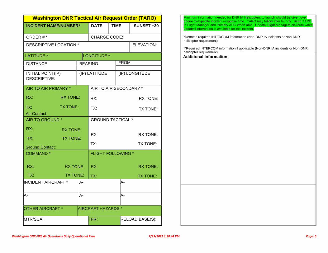
Washington DNR Tactical Air Request Order (TARO)
INCIDENT NAME/NUMBER* DATE TIME SUNSET +30
ORDER # * CHARGE CODE:
DESCRIPTIVE LOCATION * ELEVATION:
LATITUDE * LONGITUDE *
DISTANCE BEARING FROM
INITIAL POINT(IP)
DESCRIPTIVE:
(IP) LATITUDE (IP) LONGITUDE
AIR TO AIR PRIMARY *
RX: RX TONE:
TX: TX TONE:
Air Contact:
AIR TO AIR SECONDARY *
RX: RX TONE:
TX: TX TONE:
AIR TO GROUND *
RX: RX TONE:
TX: TX TONE:
Ground Contact:
GROUND TACTICAL *
RX: RX TONE:
TX: TX TONE:
COMMAND *
RX: RX TONE:
TX: TX TONE:
FLIGHT FOLLOWING *
RX: RX TONE:
TX: TX TONE:
INCIDENT AIRCRAFT * A- A-
A- A- A-
OTHER AIRCRAFT * AIRCRAFT HAZARDS *
MTR/SUA: TFR: RELOAD BASE(S):
Minimum information needed for DNR IA Helicopters to launch should be given over phone to expedite incident response time. TARO may follow after launch. Send TARO to Flight Manager and Primary ADO when able. Update Flight Managers en-route when updated information is available for the incident.
*Denotes required INTERCOM information (Non-DNR IA incidents or Non-DNR helicopter requirement) **Required INTERCOM information if applicable (Non-DNR IA incidents or Non-DNR helicopter requirement)
Additional Information:

Washington DNR FIRE Air Operations Daily Operational Plan 7/23/2021 1:28:44 PM Page: 7
Abbreviations
(T) Trainee
A/A Air to Air
ADM-AO Assistant Division Manager – Operations & Aviation
ADO Aircraft Duty Officer (DNR)
A/G Air to Ground
AFM Aircraft Flight Manager
AML Aircraft Maintenance Lead
AMS Aircraft Maintenance Supervisor
AOPS DNR Aviation Operations Plan & Standards
ASO Aviation Safety Officer
ATGS Air Tactical Group Supervisor
BMIDC Blue Mountain Interagency Dispatch Center
CCICC Columbia Cascade Inter-Agency Coordination Center
CHLN Chelan County
COA Chief of Air Operations
COA Colville Agency (BIA)
COF Colville National Forest (USFS)
CP Chief Pilot
CWICC Central Washington Inter-Agency Coordination Center
DAC Daily Aircraft Coordinator
DGEN Douglas County
DNR Department of Natural Resources
DO Duty Officer
EA Extended Attack
EOC End of Contract
EOS End of Shift
FCT Vagabond Army Heliport
FM Flight Manager
FTA Fire Traffic Area
FW Fixed Wing
GPF Gifford Pinchot Nation Forest (USFS)
H Helicopter
HLCO Helicopter Coordinator
HEMG Helicopter Manager
HPM HELITACK Program Manager
IA Initial Attack
IP Instructor Pilot
IROC Interagency Resource Ordering Capability
JBLM Joint Base Lewis-McChord (Military)
KTTN Kittitas County
LAT Large Air Tanker
MCR Mid-Columbia Refuge (USFW)
MHF Mt Hood National Forest (USFS)
MSF Mount Baker/Snoqualmie Forest (USFS)
MTP Maintenance Test Pilot
MRP Mt Rainer National Park (NPS)
MX Maintenance
NCP North Cascade National Park (NPS)
NES Northeast Region (DNR)
NEWICC NE Washington Inter-Agency Coordination Center
NPS National Park Service
NWS Northwest Region (DNR)
OLF Olympic Nation Forest (USFS)
ONP Olympic Nation Park (NPS)
OLS Olympia Region (DNR)
OTS Out of Service
OWF Okanagan Wenatchee Forest (USFS)
P Pilot in Command
PCS Pacific Cascade Region (DNR)
PIC Pilot In Command
PSC Puget Sound ICC
PSICC Puget Sound Inter-Agency Coordination Center
RON Remain Over Night
RTB Return To Base
RTS Return to Service
S Scooper
SEAT Single Engine Air Tanker
SEMG Single Engine Tanker Manager
SES Southeast Region (DNR)
SMS Safety Management System
SPD Spokane District (BLM)
SPS South Puget Sound Region (DNR)
(T) Trainee
TARO Tactical Aircraft Request Order
TFR Temporary Flight Restriction
UMF Umatilla National Forest (USFS)
VLAT Very Large Air Tanker
WACCC Columbia Cascade Communications Center
WD Wildfire Division
WFS Washington Fire Service
WWF Walla Walla Whitman (USFS)
WWLN Walla Walla County
YAA Yakama Agency (BIA)
YKCN Yakima County
YTC/YFC Yakima Training/Firing Center (Military)
AIRPORTS & HELIBASES
0S7 Scott
1S9 Chewelah
2S0 Twisp
2S8 Wilbur
2W3 Swanson/Eatonville
3W7 Grand Coulee
4S2 Jernstedt/Hood River
4S6 Tieton State Airport
4W0 Bandera (North Bend)
5S5 Packwood Airport
63S Colville Airport
74S Anacortes
ALW Walla Walla
AWO Arlington
BLHB Big Lake FD Helibase
BLI Bellingham
BVS Skagit
CBHB Camp Bonneville Helibase
CLS Chehalis
CZK Cascade Locks
DEW Deer Park Airport
DLS Dallesport
DPHB Deer Park Helibase / FD
EAT Pangborn
ELN Ellensburg
EPH Ephrata
ESW Easton Airport
HQM Hoquiam
KLS Kelso
LWS Lewiston
M94 Desert Aire Airport
MHB Malaga Helibase
MWH Moses Lake
OLHB Olympia Helibase
OMK Omak
PUW Pullman/Moscow Airport
PWT Bremerton
R49 Ferry Co. Airport
RLD Richland Airport
S10 Lake Chelan Airport
S20 Goldendale Airport
S40 Prosser Airport
S52 Methow Valley Airport
S70 Othello Airport
S93 Cle Elum Airport
S97 Anderson (Brewster)
SHN Shelton/Sanderson
SSHB Sunny Slope Helibase (EAT)
TTD Troutdale Airport
W01 Tonasket Airport
YKM Yakima Airport
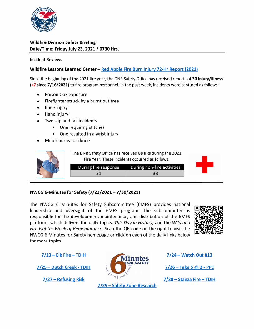
Wildfire Division Safety Briefing Date/Time: Friday July 23, 2021 / 0730 Hrs.
Incident Reviews
Wildfire Lessons Learned Center – Red Apple Fire Burn Injury 72-Hr Report (2021)
Since the beginning of the 2021 fire year, the DNR Safety Office has received reports of 30 Injury/Illness (+7 since 7/16/2021) to fire program personnel. In the past week, incidents were captured as follows:
• Poison Oak exposure • Firefighter struck by a burnt out tree • Knee injury • Hand injury • Two slip and fall incidents
• One requiring stitches • One resulted in a wrist injury
• Minor burns to a knee
NWCG 6-Minutes for Safety (7/23/2021 – 7/30/2021) The NWCG 6 Minutes for Safety Subcommittee (6MFS) provides national leadership and oversight of the 6MFS program. The subcommittee is responsible for the development, maintenance, and distribution of the 6MFS platform, which delivers the daily topics, This Day in History, and the Wildland Fire Fighter Week of Remembrance. Scan the QR code on the right to visit the NWCG 6 Minutes for Safety homepage or click on each of the daily links below for more topics!
During fire response During non-fire activities 51 33
7/23 – Elk Fire – TDIH
7/24 – Watch Out #13
7/25 – Dutch Creek - TDIH
7/26 – Take 5 @ 2 - PPE
7/27 – Refusing Risk 7/28 – Stanza Fire – TDIH 7/29 – Safety Zone Research
The DNR Safety Office has received 88 IIRs during the 2021 Fire Year. These incidents occurred as follows:

Tech Tip – Air Quality Washington
Washington State Department of Ecology’s Air Quality Program maintains an air monitoring network to accurately measure air pollution and meteorology conditions around the state in partnership with EPA, tribes, and local clean air
agencies. This smart phone app can be used to stay informed about current air quality conditions and provides guidance on mitigations that can help protect health. You can download this free application through your respective app store and start tracking.
Other air quality resources:
• Airnow.gov • Washington Department of Ecology • Washington Smoke Information
Safety Recognition – NE Region Fire Facility This summer NE Region – North Columbia Fire Program has been busy moving into a new workspace at the regional office. In the process a new parking area was installed and the need for vehicle protection was identified to protect the unit’s gas and electrical utilities from vehicle damage. Quick action by region management, fire staff, and the regional safety committee ensured appropriate vehicle protection was provided in a timely manner. Great job all!
### END OF REPORT ###
June 2021 July 2021

Tom Merritt, Incident Commander
Isabelle Hoygaard, Public Information Officer
Fire Information (509) 808-6720 (Call or Text)
Goddard Road Fire
News Release - July 23rd, 2021
Rice, WA: The fire had a significantly reduction in fire
behavior yesterday due to cooler temperatures and lighter winds. This allowed crews to make further progress into mop-up operations and gaining on reducing hotspots to the 25-50 foot interior. Crews will continue to work over the next few days to ensure hot spots are out to 150 feet or where necessary to contain the fire line and 500 feet around structures. A Palm IR unit (which utilizing infrared technology to identify heat or hotspots along the fire edge) is progressing around the fire edge, identifying hotspots for crews to extinguish.
Today, crews will continue to work along the fire edge, identifying hotspots (burning stump holes, burning forest litter debris, and other pockets of burning material) and extinguishing them. Hose lays have been set up around the fire where necessary to help facilitate the removal of the hotspots.
All level 3 evacuations have been dropped to a level 2. Level 2 means to be prepared to leave at a moment’s notice.
State mobilization resources are being demobilized and sent to other fires where needed. Additional crews are arriving to replace the state mobilization resources.
Moderate winds will form later today with low relative humidity, which has a potential to increase fire behavior, especially in the afternoon. Interior pockets of fuels could flare up, creating small plumes of smoke and visible flames.
Quick Facts Goddard Road Summary
Approximate Size
784 acres
Containment
Overall: 45%
Resources
30 - Engines 3 - 20 Person Crew
2 - Dozers 8 - Tenders 1 - Skidgine
Total Personnel
235
Fire Danger Extreme
Structures Damaged / Destroyed
1 primary destroyed 2 secondary destroyed
Follow Us on Inciweb:
https://inciweb.nwcg.gov/incident/7676/
PUBLIC AND FIRE FIGHTER SAFETY IS THE NUMBER ONE PRIORITY
Do not enter into the burn area of the fire. Fire weakened trees can fall suddenly and hot deep ash pits can cause severe burns and are present within the burned area.
This Fire Update was produced by Northeast Interagency Incident Management Team 1
@NEWIMT3 @NEWIMT @NewFireInfo
Follow Us for Updated Fire Infomation:

Shawn Soliday, Incident Commander
Fire Information Center (509) 990-6218 : Call or Text
News Release July 22nd, 2021
Wellpinit, WA - The Sherwood Fire is located about 2 miles Northeast of Wellpinit, WA. It started on Wednesday, July 21st and has burned approximately 375 acres of forest land.
Northeast Washington Incident Management Team 3 was dispatched to assist the initial suppression efforts by Spokane Tribe of Indians, and Washington State Department of Natural Resources. Fire camp is established at the Spokane Tribal Pow Wow grounds.
Last night fire crews worked on getting fire line around the fire and were able to get 30% of the fire lined.
Today, Crews are working on establishing a fire line around the fire.
Social Media:
https://www.facebook.com/The-Rawhide-Press-129267947115446
Quick Facts Sherwood Fire
Incident Start: July 21, 2021
Incident Approximate
Size:
Approx. 375 acres
Fire Containment:
0% Contained 30% Lined
Assigned Resources
on the Incident
Hand Crews: 2
Engines: 4 Dozers 2
Total Personnel on
Incident:
50
Fire Cause: Under Investigation
Evacuation Orders:
Level 3 – Go Now: Cottonwood Road east of Drum Road west of.
Wilkinson road. Level 2 – East of
Wilkinson road, this includes the Boardman
housing area.
Road Closures for thru traffic
Drum Cottonwood Wilkinson
PUBLIC AND FIRE FIGHTER SAFETY IS THE NUMBER ONE PRIORITY
This Fire Update was produced by Northeast Interagency Incident Management Team 3