willowemoc wild forest unit management plan - dec.ny.gov · construction of the newburgh -...
TRANSCRIPT
.DEC Publication
WILLOWEMOC-LONGPOND WILD FOREST
UNIT MANAGEMENT PLAN
October 1991
New York State Department of Environmental Conservation


WILLOWEMOC - LONG POND WILD FOREST
UNIT MANAGEMENT PLAN
OCTOBER,. :tff:t
New York state Department of Environmental Conservation
Mario Cuomo Governor
Thomas c. Jorling Commissioner


OCT 0 7 1991
TO: The Record
FROM: Thomas C.
RE: Unit Management Plan Willowemoc-Long Pond Wild Forest
The Unit Management Plan for the Willowemoc-Long Pond Wild Forest has been completed. It is consistent with the guidelines and criteria of the Catskill Park State Land Master Plan involved citizen participation, is consistent with the State Constitution, the Environmental Conservation Law, rules, regulations and policy. The Plan includes management objectives for a five-year period and is hereby approved and adopted.
cc: L. Marsh


WILLOWEMOC - LONG POND WILD FOREST
UNIT MANAGEMENT PLAN
PREFACE
Unlike the more mountainous regions to the north and east
which typify the Catskills, the Willowemoc - Long Pond Wild
Forest is an area of subdued terrain with several ponds and a
diversity of wetlands. Adding to the unique character of this
unit is a network of wood roads providing both access and an
opportunity for a variety of outdoor recreation. Having only
recently acquired (1987/89) a nearly 4,000 acre portion of this
unit where most of this network of wood roads exist, a primary
focus of this management plan is to propose appropriate
recreational use of this trail network.
The following plan identifies the various resources, both
natural and man-made, which make up the Willowemoc-Long Pond Wild
Forest. It describes the historical and cultural influences
which have shaped the character of the area. Issues and
constraints affecting the unit are noted, and both goals and
objectives have been developed which will govern the area's
future management. The plan proposes specific projects to
fulfill these goals and objectives. Although much of the
information contained within this plan was developed by
Department staff, public input was essential in the decision
making process.
iii

This document represents management objectives rather than a
work plan of commitments. Accomplishment of management actions
outlined herein is dependent on legislative budget
appropriations, and sufficient personnel to carry them out.
However, where possible the Department will work with volunteer
groups and pursue alternative funding sources to accomplish some
of the proposed projects. For example, volunteers from the
Livingston Manor area recently constructed three bridges on the
snowmobile trail along the east side of Mongaup Pond, and
volunteers from the NY-NJ Trail Conference have helped the
Department maintain several of the hiking trails in the
Catskills, including the Mongaup-Hardenburg Trail.
tlllli.t Management Planning Coordinator: Bil.l. Rudge
Region 3 staff Contributors
Lands and Forests: Frederick Gerty, Jr. - Regional Forester Jerry Gotsch - Associate Forester Herbert Lepke - Forest Ranger Anthony Lenkiewicz - Forest Ranger Robert Marrone - Forest Ranger Robert Zurek - Forest Ranger R. Andrew Burgher - Land surveyor
Fisheries: Robert Angyal - Senior Aquatic Biologist
Wildlife: Ted Kerpez - Conservation Biologist
Operations: John Harrington - Regional Operations Supervisor
Law Enforcement: Howard Wendler - Lieutenant
Regulatory Affairs: Bill Steidle, Associate Environmental Analyst
Central Office: Margaret Baldwin - Cartographer
NYS DEC 21 South Putt Corners Raad
New Paltz, NY 12561 914-255-5453
Cover Photo: Long Pond - F. Gerty, Jr.
iv

TABLE OF CONTENTS
PREFACE . PAGE
. iii
TABLE OF CONTENTS v
Location Map vii
I.
II.
INTRODUCTION • A. Area Description
1. Location . 2. Access • 3. size . 4. Topography •
B. History • Land Acquisition History Map
INVE.li'l!OB.~. USB &llD C&PACITY TO WITHSTAND USE • A.
B. c. D. E. F.
Natural Resources • • • 1. Physical Resources
a. Geology •••••• b. Soils • • • • • • • c. Terrain • • • • d. Water . • . • • • • • o • • •
e. Wetlands • • • • • Biological •••.• - - - •••••••
. . . -
. . a. Veqetatiarr • • • • • • • • • • • ~ • - • b. Wildlife • • • • c. Fisheries . • • ~ 6 • • • • •
3. Visual Resources • • • • • • • • ••• 4. critical Habitat • • • • • • • • • • • 5. Wild Forest ........ - ••••••• Man-Made Facilities • • • • • • • • • • cultural Resources • • • • • • • • • • • • • • • • Economic Impact .. • • • ... .. .. • .. • • • • • Public Use • • • • • • • • • • • • capacity of the Resource to Withstand Use •
1 1 1 2 4 5 6
18
19 19
. 19 19 21 22 23 24 24 24 28 31. 32 33 33 35 47 47 48 51
III. MANAGEMENT AND POLICY • ~ • • • • • 56
IV.
A. B. c.
A. a., c. D.
Past Management • • • • • • • • • • • • 56 Constraints and Issues. • • • . • • • • • • . • • 58 Goals and Objectives .. • • • .. ., .• ., ., • 62 1. Goals • • • • • • • • • • • • • • • • • • 62 2. Objectives • • • • • • • • • • • • o • • • • 62
PROJECTED USE AND M'.ANAGEMEHT' PROPOSED • 66 Facilities Development and or Removal • 68 Maintenance and Rehabilitation of Facilities • • • 73 Public Use Management and Controls • • • • • • • • 75 Fish and Wildlife Management • o • • o • • 87 1. Fisheries • • • • • • . • . . 87 2. Wildlife • • • • • • 88
v

v.
VI.
E. F. G.
H. I. J.
TABLE OF CONTENTS
Wild, Scenic and Recreational Rivers . • • Fire Management . . . . . . . • . • Administration . . . . . • . . • • . . . • . . • . 1. Staffing . . . • . • ••..... 2. Education . • . • .. Land Acquisition . . . • • • . • • • • • . Catskill Park State Land Master Plan Amendments SEQR Requirements . • . . . . • • • . • • .
SCHEDULE FOR IMPLEMENTATION/BUDGET •
BIBLIOGRAPHY AND REFERENCES
PAGE 88 89 90 90 92 93 94 94
95
101
VII. APPENDICES A. Environmental Assessment and SEQR Declaration . . . 107 B. Wildlife/Fisheries Inventory . • • . . . . . . 120 c. Sign Inventory . . . . • • • . • • • . . . . . . 126 D. Easements • . . . . • • • • • . • • . . . • . • • 13 2 E. Topographic Map • . . • • • • • • . • • • Unavailable F. Wetlands and Wildlife Map • • • . • . • . • Insert G. Facilities Map (Existing and Proposed) Insert H. Department of Environmental Conservation Address
and Phone Numbers ....... .,.. • • • • Back Cover
vi

,' ' '
• \Ii l L0wet00e ~ Wild , 0 ,,.;Long Ponl
'Y m Other Forest Pr r£,,(.,,/'~ eser~ I\ Other State l&M
* ~Campground
Stllrte Ski Center
R V
BOVINA
L AN D
vii


I. INTRODUCTION
A. Area Description
1. Location
The Willowemoc - Long Pond Wild Forest is a
management unit in the southwestern portion of
the Catskill Park. It is made up of Forest
Preserve lands in the Towns of Neversink and
Rockland, Sullivan County and the Towns of
Denning and Hardenburgh, Ulster County.
While most of the unit is made up of one
large contiguous parcel, it also includes
several smaller "detached" parcels (see Size).
These lands are a part of the Hardenburgh
Patent, Great Lots 4, s, and 6 (ttre majority o~
the lands being in Great Lot 5).
The unit is bordered an tb.e northeast by
the Big Indian - Beaverkill Range Wilderness
Area. Where the unit directly abuts this
wilderness area no "on the ground" boundary
exists ..
The unit also abuts (nearly surrounds) the
Mongaup Pond Campground - forest preserve land
classified as an intensive use area. The
campground's boundary is posted with "restricted
area." signs which prohibit hunting (in the
campground) .

The Village of Lew Beach is approximately 3
miles west of the unit, Willowemoc is nearly the
same distance south of the main unit (just north
of the "Willowemoc" detached parcel), and
Claryville is.approximately 4 miles east of the
unit. Livingston Manor, the closest village
with significant amenities, is approximately 9
miles southwest of the unit. Liberty is about
18 miles to the south.
2. Access
There are four principle access points to
the main body of this unit:
Round Pom:t Road (eastern end of unit) ..
Prom Liberty east on State Route 55, or
from Napanach west on State Route 55 ta
eurry. North on Sullivan County Route 1.9
tQ C.l.aryville. West on Sullivan County
Route 157 (changes to Ulster County Route
47 - West Branch Raad) about 1.3 miles to
Round Pond Raad. West .6 miles on Round
Pond Road to Black Bear Road. North on
Flugertown Road (eastern end of unit).
From Round Pond Road (above) continue west
2

past Black Bear Road into Sullivan County
on what is now called the Pole Road
approximately 4 miles to Flugertown Road.
North on Flugertown Road.
Mongaup Road (Central part of unit). From
Route 17/Livingston Manor (Exit 96) East on
Sullivan County Route 81 six miles to
DeBruce. North on Mongaup Road 2 miles to
Fork. Left fork 1/3 mile to Frick Pond
Parking Lot; right fork 1 mile to Mongaup
Pond campground.
Shin creek Road (northwest end of unit).
From Livingston Manor North on Sullivan
County Route 1.51. (Johnson Hil.l. Road) about
10 miles to Lew Beach. East about
3.5 mil.es on Shin Creek Road.
Detached Parcel Access The Craige Clair
detached parcel can be reached from the
Craige Clair Road via the Beaverkill
campground (direct access from the Craige
Clair Road has not been developed)e
Johnson Hill Road provides access to the
l

3.. Size
Waneta Lake parcel. The western Beaverkill
detached parcel can be reached by foot from
forest preserve lands along the east side
of the Shin Creek Road. The other two
Beaverkill detached parcels are
inaccessible. The Willowemoc detached
parcel can be reached via several town
roads including Conklin Hill Road,
Parksville Road, Woodard Road and Aden Hill
Road. The detached parcel north of Church
Road is inaccessible. The forest preserve
lands in Ulster County which include Fall
Brook and Flat Brook can be accessed via
the Blarc:k Bear Road or by foot via the now
abandoned Tyler Place Road.
This unit encompasses approximately 14,870
acres of Forest Preserve lands, most of which
lie within one large, contiguous parcel. Eight
smaller detached parcels in close proximity to
the main parcel are included in this management
unit. ~h~ ~i~~ nf ~~r.h nf Tn~~A n~rr.~l~ r.~n h~ --·- ---- -- ------ -- ------- .-- ---- ---- ---
found in Table 1.
4

The main unit is over 11 miles long and
ranges from .5 to over 4 miles wide.
Table 1. Size of forest preserve parcels comprising the Willowemoc - Long Pond Wild Forest.
PARCEL NAME/DESCRIPTION
Main Unit (Quick Lake, Frick Pond, Long Pond, Fir Brook)
Craigie Clair Waneta Lake Beaverkill (West) Beaverkill (Central) Beaverkill (East) _ Willowemoc/Conklin Hill/Aden Hi11 Church Road Fall Brook/Flat Brook (Ulster county)
Willowemoc - Long Pond Wild Forest
4.. Topography
TOTAL
ACREAGE
11,268
235 251 29.9 30.6 12 .. 2
1,679 48
1,316
14.869.7
This unit is not as mountainous as other
areas in the Catskill Park. Streams and ponds
are more prominent than peaks. While steep
sided ridges are common, elevations vary little
more than 1,000 feet throughout the entire unit.
The high point being 3,100 feet above sea level
near the summit of Beech Mountain (the 3,118
foot summit being on private land adjacent to
the unit) e
5

B. History
The Lenni Lenape Indians, members of the
Algonquin Indian nation, were probably the first to
utilize the region for its plentiful fish and game.
They developed the first transportation route into
and through the area with their so called Sun Trail
which followed the route of the sun (east - west)
from the Hudson (Kingston) to the Susquehanna
(Binghamton). They were also responsible for many of
the area's place names, including Willowemoc, the
name of a local group of Lenni-Lenape Indians, and
Neversink, an Indian name with several possible
meanings (a mean, mad river; a continual running
streanrwhich never sinks into the ground; a highland
between waters or water between highlands} (Quinlan,
1873).
In 1706 the Indian sachem (wise man) Naisinos is
said to ha.ve. said a iarge tract of land which
included the ca.tskill Mountains to Johannes
Hardenbergb: for 60 pounds. Having thus cleared any
title claims the Indians may have had with the area
Hardenbergh then persuaded Queen Anne of England (in
1708) to grant him and his associates title to the
region. This grant became known as the Hardenbergh
Patent and encompassed nearly 2,000,000 acres.
6

Various disputes and survey problems followed
which led to arguments over title to various lots
within the patent. The uncertainty kept most
settlers out of the region and the Catskills remained
an undeveloped wilderness until the 19th century.
Construction of the Newburgh - Cochecton
Turnpike in 1809 led to the first real opportunity
for settlement of Sullivan County. Passing through
Monticello and Bethel, it provided an essential link
between the county and the commercial and banking
center of the region (Newburgh) (Heidt, 1956).
The hamlet of DeBruce takes its name from James
Desbrosses who owned most of the land in Great Lot 5
of the Hardenbergh Patent, which included most of the
lands in the Willowemoc - Long Pond Wild Forest.
Shortiy after tb.e Revoiutionary War he and John R.
Livingston, who owned much of Great Lot 4, began ta
encourage tenants to settle their lands. Debrosses
died in 1811 and his lands were divided equally
between his two daughters, Elizabeth Hunter and
Charlotte Overing. Soon after acquiring the lands
his wife inherited, John Hunter employed Abel Sprague
to cut and make Hunter Road over the old Sun Trail of
the Indians. Starting in Shin Creek, Sprague worked
eastward until reaching Grahamsville. Completed in
7
1815, it brought many new settlers to the area
{Tiffany, 1976; Quinlan 1873).
Farming was probably the first economic activity
in the area (Schieppati 1990). Small sawmills soon
arose and as transportation routes improved in the
mid 1800's, the leather tanning industry expanded
from the eastern Catskills into Sullivan County.
Animal hides imported from Argentina were shipped to
the Catskills where Heml..ack (the bark of which was
the source of tannin, an essential ingredient in the
tanning process) were abundant.
In 1856 Stoddard Hammond and James Benedict
contracted with John Hunter, Jr. for the bark on
35,000 acres of land and conunenced ccmstructicm of
one of the most extensive tanneries in the County at
DeBruce. Costing $70,000 and employing so-ioo men,
the tannery had the capacity to manufacture 60,000
sides Qf l.eather annually.. To I.ink the tannery with
the toll road in Claryville, the owners constructed
the Pole Road, a toll road constructed of logs laid
side by side with their tops hewn flat. Each farmer
along the road maintained 80 rods of the road and
charcn:~d a tnll fnr it;::. n;:::.p_ -----J-- - ---- --- --- ----
By 1864 there were 40 tanneries in Sullivan
County, including one at Claryville and one at what
is now the Beaverkill Campground. Thousands of
8

hemlocks were cut down and peeled of their bark
annually and by the late 1880 9 s all but the most
inaccessible hemlock stands had been cut. Although
some hemlock wood was utilized for bridge planking or
other local uses, lt is estimated that 95% of the .
barkless, fallen trees were left to rot in the woods
(Kudish 1971). Faster growing, more light-tolerant
hardwood species invaded areas where the hemlock had
once dominated, setting the stage for the wood
chemical industry which followed.
The Industrial Revolution in England and latter
in the U.S. generated a need for certain chemicals
used principally in the manufacture of woolen cloth.
rn the mid 1800 • s a technique for makil'ICJ' these
chemicals by destructively distilling hardwoods was
introduced in the U.S. from Scotl.and.. Within a few
years acid factories were constructed in the western
ca.tsk.i.l.ls. Acid factories utilized hardwoods to
manufacture wood alcohol, acetate of lime and
charcoal.
The acid factory business was well suited to the
Catskills. They required an abundance of hardwood
timber as a raw material, large quantities of water
to cool the distillation machinery and unskilled
labor to harvest the raw material and work in the
plants.

The distillation process used in the acid
factories was relatively complex, and for a time was
referred to as the "Secret Process." hardwoods
(preferably birch, beech and maple) were cut into
four foot lengths by independent wood cutters. Once
cut, all pieces over six inches in diameter were
split to assure complete carbonization. Horse teams
with wagons or sleds were used to haul the wood to
the factory yard where it was allowed to air dry.
Once properly dried (usually for a year), it was
carried into the factory and loaded into the retorts.
A retort was an iron cylinder three and one half feet
in diameter and eight feet long set horizontally in
masonry above a fire box. One end of the retort was
fitted with an airtight iron door, the other end was
tapered and led to the condenser. Once charged with
woad, the retort door was closed, 1ocked and sealed
with cl.ay ta be sure. na air entered. A fire was then
lit in the firebox (Coal or charcoal) and the
temperature was slowly brought up to 520 degrees
Fahrenheit and held there. As the wood gradually
changed to charcoal, gases were produced which
condensed in a copper still (condenser). The
resulting pyroligneous acid was collected in wooden
tanks (turns). This was then mixed to produce
methanol and a crystalline powder known as acetate of

lime. These were the key products of the industry.
They were usually shipped by rail to seccm.da:cy
manufacturers. Methanol was used in paint,
varnishes, smokeless powder and later for antifreeze.
Acetate of lime was converted to acetic acid which
was used as an intermediate in the manufacture of
textiles (color-fast dyes) and vinegar. It was also
important in the photographic process and in the
production of other chemicals such as acetone.
Charcoal, a by-product of the early factories, was
used in the manufacture of charcoal iron, as well as
a fuel for the retorts in the factory. It was not
until the 1940's that it became popular for cookinq.
Tfre lt'lllCJ Brothers' established the first acid:
factory in Sullivan County in 1878 at what is now
appropriately called Acidalia. 'rhe. nex.t twenty years
saw a massive expansion of the acid factory business.
Small plants were built throughout Delaware and
Western Sullivan county. Because wood was hauled to
the plant by horse teams, and because it would not
have been profitable to send these teams a long
distance, wood was harvested within a close radius of
the plant~ When the nearby wood supply was
exhausted, the factories would either be closed or
dismantled and moved to an area with an abundant wood
supply. In connection with their factories, most

owners also had a sawmill. The choicest logs were
sent to the mill where as the low grade hardwoods
were sent to the acid factory. In this fashion much
of the area between Livingston Manor and Walton was
completely stripped of wood.
"Harry" Treyz operated two acid factories in
Sullivan County, one in Livingston Manor and one in
Willowemoc. The Willowemoc plant was built in 1891.
It had 24 retorts and employed 25 people. Fire
destroyed the plant in 1925. Hammond and Fish
operated factories in Grooville and DeBruce from 1880
to 1898.
Heavy demands for wood chemicals by World War I
brought a temporary boom to the rmfustry which at its
peak consumed 1~0,000 cords of wood annually and
empl.oyed 3,000 men in Delaware and western Sul.l.ivan
County.. However, German scientists workinq under
pressure o.f wcu: developed a synthetic substitute for
the chemicals which were in great demand. While some
factories survived by adopting new ways and
developing new markets, by the end of World War II
only a handful of plants were left. Interestingly
enough, during the final years the only marketable
product was charcoal, originally considered a
"stepchild'• of the industry (Myers, 1986) ..

Other wood using industries have had an
important effect on the area as well. Saw mills in
Lew Beach, Beaverkill, Craigie Claire, Grooville,
Willowemoc and at the Outlet of Lake Juanita (Waneta)
likely derived their raw material from lands now
comprising this unit. The Sherwood Mill at
Livingston Manor which produced table legs, Indian
Clubs, dumbbells and baseball bats became a_major
wood-using mill in the region. Until 1900, all
Spaulding baseball bats were made at Sherwood's
plant. After a fire destroyed the mill in 1916, it
was rebuilt to turn out first grade ten-pins of rock
maple. rn the 1880' and 1890's, Parksville was a
center for quantity shippinq of small spruce and fir
trees that were sold in New York city as Christmas
trees.. When the local stock was depl.eted the
industry died (Wakefield, 1970).
As each •era" in this unit's history can be
traced to the development of a transportation route
into the reqion (The Sun Trail, the Newburgh
Cochecton Turnpike, the Hunter Road and the Pole
Road) in no case is this truer than that of the
recreational industry. Development of the New York
and Oswego Midland Railroad in 1873, later known as
the New York, Ontario and Western Railroad -- not
only opened the area to visiting fisherman, hunters
13

and other recreationalists, it actively encouraged
its development. As Austin Francis noted in his book
"Catskill Rivers," the railroads created an
"accessible remoteness. 11
In 1878 railroad management had 1,500,000 brook
trout and a large number of lake and California trout
distributed throughout the region. More trout were
stocked in successive years and in 1891 J. c.
Anderson, passenger agent for the o. and W. Railroad
made application to the State Fish Commission for
600,000 trout fry. That some year a bill to
establish a fish hatchery in Sullivan County passed
in the State Assembly and is said to have led to the
creation of the DeBruce Hatchery on Mongaup Creek.
Wakefield, in his book "To the Mountains by Rail"
credits the Ontario and Western Railroad management
with laying the groundwork for what has become one of
the classic trout fishing regions in the wor:Ld.
Wakefield also speculated on the creation of the
Beaverkill Public campground:
"On August 9, 1923, a young Boy Scout from Liberty, bound for a vacation day's enjoyment, was dismayed to see the lower Willowemoc's surface dotted with innumerable dead fish floating downstream. After due investigation • • . it was theorized that some sort of poison had been released from the acid factory at Willowemoc. Whether or not the negative publicity for the county was a factor is not known, but a positive follow-up was the

approval of the purchase of the locally known Beaverkill tannery farm in October, 1926, to be preserved as a state park and campsite area."
Of course the local people were well aware of
the area's wealth of hunting and fishing resources,
and took advantage of them long before the tourists
arrived by rail. James Quinlan, in his "History of
Sullivan County" tells a particularly interesting
story about the area:
"Cyrus Dodge had a.thrilling adventure with panthers at Long pond*, a beautiful sheet of water once famous for its large trout, and for the number of deer found in its neighborhood. On a summer-afternoon he was watching for deer as they came to water, and stood under some large trees which grew on the shore. While thus engaged he heard a suspicioua noise over his head, and looking up, saw a panther on a limb above him. The animal was watching him intently. Thinking there was no time to be wasted in observing its movements, Dodge brought the butt of his gun to his shoulder and fired. The report of the snot was followed by a dull thud at his feet, and the convulsive boundings of the dying panther, as well as the leaping of several l.ithe forms in the overhanging tree-taps. Dodqe declared that the woods seemed to be alive with panthers, and he felt th~ was in great peril. Knowing the aversion of the cat-tribe to water, he instantly sprang into the pond, and waded out ~ where it was waist-deep. As he loaded his gun, he counted no less than five panthers in the neighboring
The pond Quinlan refers to as Long Pond in this story is very likely what is now named Tennanah Lake (Town of Fremont) rather than the Long Pond within the Willowemoc -Long Pond Wild Forest. 'l'he present day Long Pond was never noted to have a significant trout fishery (E. Van Put).
15

trees. They were undouo~ea~y an o~a she-one and her young. The latter, although weaned and nearly full-grown, had not separated from their mother, but continued to follower her until fully able to provide for themselves. Dodge continued to load and fire until three more had bitten the dust. The other two he failed to see a second time. They were probably frightened by the report of the gun, and ran off. He then went on shore, skinned the four panthers, and struck a bee-line for home very sensibly concluding that deer-hunting in that quarter was too dangerous for enjoyment."
The 20th Century saw a rapid expansion of the
summer resort business. Initiated with the rail
service to the region, it intensified with the advent
of the automobile. Today it is the prime industry in
the county.
New York state began acquiring lands making up
the Willowemoc - Long Pond Wild Forest as early as
1885, when several lots in the Town of Denning
reverted to the state due to delinquent tax payments
(see Figure 1)~ Most of the lands comprising this
unit were a.cqui.:ced in the l.ate 1-920's and earl.y
1930's with money from a land acquisition bond act
approved by the voters of the state in the 1924
General Election. The majority of the lands acquired
at that time were purchased from one owner
Elizabeth White of Cooks Falls; New York~ Mrs~
White, whose maiden name was Elizabeth Clark
Leighton, was the daughter of Arthur Leighton who
owned and operated several acid factories in the
16

region. Significant additions were made to the unit
with money from the Park and Recreation Land
Acquisition Bond Act of 1960, including the lands
surrounding Mongaup Pond and Waneta Lake. The 1986
Environmental Quality Bond Act provided funding for
the most recent additions to the unit. Lands west of
Mongaup Pond, including portions of the former Beech
Mountain Boy Scout Camp (including Frick Pond) and
Quick Lake were purchased in 1987 and 1989 from the
Open Space Institute (O.S.I.), a conserva~ion group
that conserves open space in land trusts. A
conservation easement over lands that O.S.I. has
retained immediately adjacent to the unit (the Beech
Mountain Nature Preserve) was also acquired by New
York state in 1989. Among other things, the easement
provides far publ~c access across the property on
trails ta be designated by O.S.I. and public fishing
at Hodge Pond {subject ta certain restrictions to be
developed by O.S.I.). For more information regarding
this easement, see Appendix D.
17

....... 00
FIGURE 1 WILLOWEMOC - LONG POND WILD FOREST
. ...., .... 7 ............... / 17 ""--~. .i] ( .............. / 1'
.1' ........ < (. .I ) ...
l., I 7 ... ,, / '' I ', ( ;) ,,....." [ .................
, i
(.1
A N D ·-
N I ·, ',
~. .., 'z --,_
r-, ......... ;'
'1 i ~ ~
1 COLCHESTER
'-< '.·- ..J
......... ~ ....
--------i--CAWJCQON / -------,,
/ ~ I B E R T y ''-·-,,, ' ,_
r'
\ i v
!IOCELAND
, ........ _ I ,,
/ ............... I '-.. ..... I -._
/' '---........ _
\ _/ . LlllERTY
.............. _ ...... __
,.. i
i I
f {\Hodg51,' \\)Pd · 1
LY\_~ 1989
I I ,_
I I
I
-, I
r,::;.,. /7 Frick 1'g;1 v Pd If".,.._../
................. ~/
I
f I
i_ r-.,/
? ! l_/
-........................ ....
/"',> ...... //
, /
'·., , , ,
, -<
, , , ,
// i
.... _-.///
I
,---_J I
r' I I
I
,/~ I
I I I
I I
I I
I I
I I
I I
/ I
I I I.
ACQUISITION HISTORY
,.-.., i
I - -------
// I /'Ir-. I I I Ii '
(,
~
H A R D E N B U R G H
//',,___ ___ ~ ,,-- -
DENNING
,........._ ,."·-, 1~' ..._
-------- ---J~:3 1927 -"'.'-, ,"---
... , '1905
-<---'.'/
()~
,..., I '· I 'v
''1933
N E V E R S I N K
I I / i / i 1
1 I I /I
/ / /I ~ i /.1 .. ./ ,,
v
6
, I
"-· J ! ,:__·':J- _,,/
i ....._ __ /
'·-1
I
' .. .//
i ,_;
i I ,
<
.~
('-, -, I
I ~
' I
'-...__ ""( ------_(
/~-........
I -..........., /
I (
I (
') I
I i
I
'-
""----/'--(' I
//
I -~
- -J
t
' I
/\/'_,;
. 0 ~~~·k.:~r-, MILES )'~

II. INVENTORY, USE AND CAPACITY TO WITHSTAND USE
A. Natural Resources
1. Physical Resources
a. Geology
The Catskill Mountains have their
origins in an ancient river delta upon
which rivers from a prehistoric mountain
range to the east were spreading gravel,
sand and mud. This sediment accumulated to
a depth of several thousand feet before ·
deposition slowed as the mountains were
worn low. Then, some two hundred million
years ago, the delta as well as the
surrounding sea-bottom of sedime11ta.ry rock:
beqan to rise to a level higher than the
region of New England whence i.ts
constituents were derived. What fo1lowed
~ a period of erosion which is
responsible for the present shape of the
Catskills.
The seabottom rock (sandstone and
shale) derived from much finer sediments
than that of the delta, were less resistant
to erosion, and gradually eroded away. The
delta, being composed of cemented gravel or
conglomerate, especially in the upper beds,
19

was very resistant to erosion. Thus the
Catskills, particularly the eastern
Catskills where the coarsest of gravel from
the ancient river delta was deposited, were
able to withstand the forces of erosion and
maintain their elevation. To the west, as
the sediments from the ancient ocean became
finer and finer, the resulting plateau was
more susceptible to the forces of erosion
and consequently the plateau was worn
down/eroded to a much greater degree.
The Willowemoc ~ Long Pond Wild Forest
was once a part of the southwestern edge of
the ancient delta, in a transition zone
between the coarser and finer sediments.
The unit was unable to resist the erosive
forces of water and ice ta the same degree
as the three main Catskiii ranges
(Northeastern, central and southern
escarpments) to the north and east. Yet it
does contain the highest elevations in
Sullivan county.
'T'h~ nnit 1 s nresent tonoaranhv is due to ---- ---- - - .L- - - - - .. .,,, .. -
the erosive action of streams which deeply
dissected the region both before and after
the ice age. While glaciation during the
20

ice age did not significantly affect the
Catskills as a whole, the southwest/
northeast alignment of some of the valleys
in this unit (an alignment which matched
the movement of the glaciers) led to the
formation of both natural lakes and broad
valleys which were easily dammed to form
man-made lakes.
b. Soils
The soils found in the Willowemoc -Long
Pond Wild Forest were formed from glacial
till that is dominantly sandstone and
partly siltstone and shale. Most belong to
the Willowemoc - Mongaup - Lewbeach
Association. These soils are rolling ta
very steep in slope, moderately deep ta
VeJ:Y deep, moderately well drained and we11
drained. medium textured and of ten very
rocky. However, some of the soils in this
unit are poorly drained and ara subjact to
ponding. · Limitations to management are the
seasonably high watertable, slow or very
slow permeability, shallow depth to
bedrock, stoniness and slope.

c. Terrain
Unlike most of the CatskilL Forest
Preserve·management units, the Wiiiowemoc
Long Pond Wild Forest does not include a
named suirunit, despite its large size.
While generally quite hilly, the majority
of the lands within this unit do not vary
in elevation more than 1,000 feet (nearly
all of this unit falls within the 2,000 -
3,ooo foot elevation range). Terrain
ranges from long, steep sided ridges like
that which dominates the western half of
the unit. running east/west between Frick
Pond and QUidt Lake, to lower elevation
wetlands, lakes and ponds like Long Pond
where the surrounding terrain is relatively
mild. Elevation· extremes range from a high
of 3,100 feet above sea level near the
summit of Beech Mountain (the J,118 foot
summit being on private land adjacent to
the unit) to a low of 1,580 feet above sea
level along Conklin Brook on the eastern
edge of the Conklin Hill detached parcel.
22

d. Water
Lands within this unit lie within the
Delaware River watershed. North and
Northwest slopes drain into the Beaver Kill
(Shin Creek, Gee Brook). Southern slopes
(Mongaup Creek, Butternut Brook, Fir Brook)
feed the Willowemoc Creek and eastern slope
drainages (Conklin Brook, Fall Brook and
Flat Brook) flow into the Neversink River.
All three of these rivers are tributaries
to the Delaware River.
The unit includes four ponded waters:
Waneta Lake -
Quick.Lake -
Frick Pond -
Long Pond -
30 acres, impounded by a man-made stone dam
4 acres, impounded by beavers (remnants of a manmade concrete/ earthen dam. exist)
6 acres, impounded by beavers
15 acres, natural lake whose level fluctuates with beaver activity
The higher elevation sections of the
Neversink and Willowemoc drainages have
been identified as being sensitive to
acidic deposition. Long Pond has proven to
be acidi~, with pH values of 4.0 - 5.0
noted during August, 1966. Water quality
is otherwise good throughout the unit.
23

e. Wetlands
Unlike other Catskill Forest Preserve
units, wetlands are relatively common in
the Willowemoc - Long Pond Wild Forest.
Seventeen classified (greater than 12.4
acres) wetlands have been identified wholly
or partially within this unit. The largest
wetland (152 acres) is found along Fir
Brook at the eastern end of the Unit.
Another large (71 acres) wetland occurs on
the Conklin Hill/Aden Hill detached parcel
south of Willowemoc. A total of 413 acres
within this unit have been classified as
wetlands (see Wetlands Map, Appendix F).
2. Biologicai
a@ Vegetation
The Wiilawemoc Long Pond Wild Forest
is almost completely forested. Exceptions
include the four ponded waters within the
unit, some of the seventeen wetlands found
throughout the unit and a few small
openings associated with past development.
The northern hardwood forest covers the
greatest part of the unit, dominated by
sugar maple and beech. Black cherry, while
24

occurring sporadically at the lower
elevations, co-dominates with sugar maple
along the higher ridges. Hemlock, white
pine, white ash, yellow birch, red maple,
big tooth aspen, basswood and red oak are
also common, but only locally abundant.
All of the lands within the unit have been
cut over at one time or another, especially
the recently acquired lands west of Mongaup
Pond (See History}.
The understory of the northern hardwood
forest is dominated by beech, sugar maple,
striped maple, black cherry and yellow
birch seedlings. Witch hobble and witch
hazel are also common. Ferns, including
the. New York fern and the. hayscented fern,
as well as various sedges, grasses and
herbs make up the ground cover.
Several conifer plantations occur on
old farmland within the unit. south of
Mongaup Pond and east of Mongaup Road along
Hunter Road are plantations of white and
red pine as well as Norway Spruce. Further
east on the north side of Hunter Road is an
extensive larch plantation. on the former
Wolf property, a part of the Conklin Hill
25

detached parcel, over 100 acres were
planted with red pine, white pine, scotch
pine, Norway spruce, white spruce and larch
in the late 1920 1 s. There are still some
open fields on this property as well.
There are several open areas in the
vicinity of Frick Pond which were formerly
utilized by the Beech Mountain Boy Scout
camp. The area was farmed prior to the boy
scouts, and the vegetation in this area
reflects this past use as well. An old
apple orchard is located just east Frick
Pond and some young sapling stands of
pioneer hardwoods both' west and south of
the pond occupy lands which were likely
cl.eared at one time for agricul.tural use.
Several loqqinq roads and other dirt
~oads traverse the unit. Some of the roads
traversing the ridge between Frick Pond and
Quick Lake are quite wide (20 - 80 feet or
more). ~hese areas are dominated by
sedges, grasses and ferns.
The Fir Brook Valley and associated
wetlands fosters a relatively rare low
elevation spruce fir forest. This may
be the westernmost outpost of red spruce in
26

the Catskills, as well as the
southwesternmost limit for balsam fir
(Kudish, 1985). While the Temporary
Commission to study the Catskills
designated the Fir Brook swamp as an area
containing rare plants (Catskill study
Report No. 15 - Rare and Endangered Plants
in the Catskills), botanist Michael Kudish
noted no rare or uncommon plants in a June,
1985 survey of the area.
Rare Plants
No endangered or threatened plant
species have been identified on lands of
the Willowemoc - Long Pond Wild Forest.
Howeve:r:. both the Northern Monkshood
(Aconitumnoveboracense) which is I.isted as
threatened on the federal. register, and.
Jacob's Ladder (Polemonium vanbruntiae)
which has been nominated for listing as
threatened on the federai register~ have
been found to inhabit lands adjacent to
this unit. Because similar habitat for
both t~ese species does occur within the
unit, it is possible that they may
inhabitant this unit.
2T
Bagdon Environmental Associates, Inc.,
an environmental consulting firm in Delmar,
New York·undertook a significant plant
habitat survey of the lands surrounding
Hodge and Frick Ponds, as well as Quick
Lake prior to New York state's purchase of
these lands. While no protected native
plants listed as endangered, threatened or
rare (as per 6 NYCRR Part 193.3) were
found, some uncommon plant species and
communities were identified (see
Bibliography and References, Section VI).
b. Wildlife
The area is located within the Catskill
Peaks and Delaware Hills ecological zone
and the wildlife which occur here are
similar to those found in other areas of
southeastern New York State. The northern
hardwood forest favors black bear, snowshoe
hare, wild turkey, gray squirrel, raccoon
and porcupine. Early successional species
such as white-tailed deer: cottontail
rabbit and ruffed grouse occur, but at
lower elevation, flatter terrain and more
diverse vegetation.
28

Breeding species of birds include. the
pileated woodpecker, yellow-bellied
sapsucker, red-breasted. nuthatch, eastern
phoebe, ovenbird, sparrows and warblers
(see Wildlife Inventory, Appendix B).
With the exception of the Atlas of
Breeding Birds in New York State {see
Bibliography and References), a formal
inventory of animal life has not been
undertaken in recent years. However,
Chambers in his handbook, "Integrating
Timber and Wildlife Management" (1983),
compiled an extensive listing of wildlife
presumed ta be in this ecological subzone,
and qualified his listing, categorizing by
forest type, forest stage and special
habitat needs. Based on Chambers•
criteria, 21 species of amphibians, 16
species of reptiles and 50 species of
mammals possibly reside in the Willowemoc
Long Pond Wild Forest.. Using both
Chambers• criteria and the Atlas of
Breeding Birds in New York state, some 134
species of birds may. nest in the unit or
utilize the Willowemoc Valley during
migrations (See Appendix B, Wildlife).
29

There are no known endangered animal
species which occur as residents of the
area. Bald eagles, peregrine falcons and
others may travel through the area during
migrations. The red-shouldered hawk,
determined to be Threatened by NYS DEC, may
reside within or adjacent to this unit. As
a threatened species it is fully protected
under Environmental Conservation Law.
However, according to the Natural. Heritaqe
Records, the red-shouldered hawk is not
known to occur in this unit.
The eastern bluebird, common nighthawk,
common raven, cooper's hawk, barn ov1,
grasshopper sparrow and vesper sparrow, as
wel.i as the smallf ooted bat, spotted
turtl.e, woad turtle, eastern hognose snake,
~e.fferson salamander, blue-spotted
salamander and spotted salamander are all
.. Special Concern" species which may reside
in this unit. Special Concern species are
those native species which are not yet
recognized as endangered or threatened: but
for which documented evidence exists
relating to their continued welfare in New
York State. The Special Concern category,
JO
while existing in DEC rules and
regulations, does not in itself provide
protection.
c. Fisheries
This unit contains four ponded waters
with fish populations. Waneta Lake has
been noted to contain largemouth bass,
chain pickerel, pumpkinseed, yellow perch,
brown bullhead and golden shiner. Long
Pond has been noted to contain chain
pickerel and golden shiner. No fish
collections are on record for Quick Lake or
Frick Pond, but they likely contain brown
bullhead, golden shiner and chain pickerel.
Several. perennial. streams traverse the
unit, includinq Fir Brook, Fall Brook, Flat
Brook, Gee Brook, Shin Creek, Mongaup
Creek, Willowemoc Creek, Butternut Brook,
Conklin Brook and the outlet of Long Pond.
Fish species found to inhabitant these
waters include brown trout, brook trout,
sculpin, blacknose dace, creek chub,
American eel, smallmouth bass, longnose
dace, golden shiner, pumpkinseed 0 yellow
31

perch, brown bullhead, white sucker,
madtom, common shiner and cutiips minnow.
Nine unnamed perennial streams have
also been identified within the unit.
While no fish collection records were
found, they likely contain brook trout,
sculpin, blacknose dace and cutlips minnow.
For a complete list of the fish species
found in this unit: see the Biosurvey
records in Appendix B.
No State or Federal endangered,
threatened or special concern fish species
have been documented within the boundaries
of the unit.
3. Visual Resources
As with other forest preserve units, the
Willowemoc - Long Pond Wild Forest is an
important component of the viewshed which makes
the Catskill Park a unique resource in southern
New York. The ponded waters within this unit
provide natural openings by which portions of
the region can be viewed.
views also exist from the abandoned farmland
within the unit. including Conklin Hill and Shin
Creek. An occasional glimpse of the surrounding
32

area can also be had from the ridge between
Frick Pond and Quick Lake.
4. Critical Habitat
Three deer wintering areas have been
identified within the unit. Located around
Mongaup and Frick Ponds, Fir Brook and
Neversink/Fall Brook, these areas provide
shelter and browse during the winter months (See
Wetlands and Wild1ife map, Appendix F).
The unit is also a part of the Catskill
black bear range and provides necessary habitat
for this species.
The Fir Brook swamp (see Veqetation)
harbors both red spruce and balsam fir, both
species nearing the extremes of their range in
the Catskills ..
5. Wild Forest
A wild forest area is a classification of
forest preeem~e where the resources can sustain
a somewhat higher degree of human use than a
wilderness area. It may contain, within its
bounds, smaller areas of land or water that are
essentially wilderness in character, where the
fragility of the resource or other factors
33

require wilderness management. A wild forest is
further defined as an area which lacks the sense
of remoteness of wilderness areas and which
permits a wider variety of outdoor recreation.
The Willowemoc - Long Pond area has been
designated a wild forest, rather than a
wilderness, for several reasons, the most
prominent being that it lacks the sense of
remoteness essential to wilderness. The unit is
made up of nine separate parcels (see Size).
Sixteen town roads traverse the unit for a total
distance of 17.2 miles. Seven private
inholdings (private land completely surrounded
by forest preserve land) are found within the
unit, and access to all of these parcels is
gained by crossing over forest prese:cve l.ands
within this unit ..
Recause the topography of this unit is not
as mountainous as other areas in the Catskil1
Park, and because an extensive road and traii
network already exists, this unit can sustain
a wider variety of outdoor recreation
opportunities than could an area classified as
wilderness.
34

B. Man-Made Facilities
1. Roads
a. Public Roads
1) Johnson Hill Road - 0.6 miles Borders west side of Waneta Lake parcel
2) Shin Creek Road - 1.5 miles
3) Beech Mountain Road - 0.25 miles
4) Mongaup Pond Road - 0.9 miles
5) Hunter Road - 1.0 mile
6) Terwilliger Road/Decker Raad -0.45 miles
7) Flugertown Road - 1.7 miles
8) Pole Road - 0.7 miles
9) Basily Road - 3.2 miles Portions of this Town of Denning Raad have not been maintained in recent years.
10) Black Bear Road - 3.2 miles
I.I.) TY1er P1ace Road - 0.25 miles
12)
13)
14)
15)
1.6)
Borders east side of Flat Brook detached parcel. This Town of Denninq road was qualified abandoned in 1925, after New York State acquired lot 132. Thus, the public has the right to utilize this road for access ta forest preserve land.
Conklin Hill Road - 1.3 miles
Anderson Road - 0.15 miles
Parksville Road - 1. 3 miles
Aden Hill Road - 0.25 miles
Woodard Road - 0 .. 5 miles
35

b. Private Roads
1. Beech Mountain Nature Preserve access road (from Shin Creek Road) -0.7 miles.
c. Private Landowner Access Easements jtraversing forest preserve) :
1. Hunter Road Access - The owner of lands south of Hunter Road and adjacent to forest preserve lands (West of Quick Lake) owns an easement allowing for access to the property from Hunter Road across forest preserve land. While the easement allows for construction of a road within the defined easement, no road has yet been constructed.
2. Panther Mountain Hunting Club Access -owners of a private inholding in the Town of Denning (Lot 109 Connecticut Tract Great Lot 6) have a right of way across forest preserve lands from Flugertown Road to their property via the now abandoned Peter Brocke Road·-0.4 miles.
3~ Buck Horn Hunting Camp Access - Owners of a private inholding in the Town of Neversink (portions of Lots 184 and 185, Great Lot 5) have a right-of-way across forest preserve lands from the Ba.sily Road to their property via an abandoned town road - 0.4 miles.
4. Hodge Place Access - The owner(s) of lands in Lot 411, Great Lot 5 now or formerly of Oliver Hodge have a rightof-way one rod wide across forest preserve land in Lot 411 from County Route 151 to the brook or lake (Waneta) for the purpose of driving stock to and from said brook or lake; for the purpose of watering same, and for .no other purpose; they also have the right to fence the one rod R.o.w.
5. · Joscelyn Road Access - The owner(s) of lands in Lot 410, Great Lot 5 (just north of Waneta Lak~ have the right of
36

ingress and egress to their lands via a 2 rod right-of-way which, in part, traverses forest preserve land -594 feet.
6. Brandy Brook Hunting Club Access - The owners of lands north of the Pole Road (Lot 119, Connecticut Tract, Great Lot 6) utilize an old town road which crosses forest preserve lands (Lot 494, Great Lot 5) from the pole road to their property - 0.15 miles.
d. Private Landowner Access Roads (Traversing Forest Preserve):
There are several private inholdings as
well as lands adjacent to forest preserve
which do not have deeded access (to the
property) yet the owners have developed
access to their property across t-orest
preserve lands. The following access roads
{undeeded) have been identified in this
unit:
i. Shin creek Road Access - The owner of lands east of Shin Creek Road (Lot 207, Robinson Tract, Great Lot 6) utilizes a road which leaves the Shin Creek Road and heads east across forest preserve (Lot 202) to access the property -423 feet.
2. Sand Pond Access - The owner of a private inholding in the Town of Denning which includes Sand Pond (Lot 114, Connecticut Tract, Great Lot 6) utilizes a road which originates on private property along the Flugertown Road and crosses forest preserve land (Lots 241 and 115) to access the property - 1.1 miles.
37

e. Forest Preserve Access Roads
1. Craigie Clair Detached Parcel AccessNew York State owns a right of way from Craigie Claire Road (just north of the Lincoln Farm Road Junction) northeast to forest preserve land (Lot 404, Great Lot 5) for public access - 0.4 miles.
2. Joscelyn Road Access - New York State has a right-of-way (2 rods wide) over this private road which runs from Sullivan County Route 151 to Waneta Lake, for administrative purposes only - 400 feet.
3. Kaeter Road Access - New York State owns a 50 foot Right-Of-Way across Lot 180, Robinson Tract, Great Lot 6 to Lot 181 trom the Shin Creek Road, commonly known as Kaeter Road, for public access - 766 feet.
4. Hunter Road Access - New York State has administrative access (but not public access) to the recently acquired lands around and including Quick Lake via Hunter Road - an abandoned Town Road (Town of Rockland) - 1. 4 miles.
5. Shin creek Farm Road Access - A woods road 1eaves the Shin Creek Road about 1 mile south of the Beaverkill Road and traverses forest preserve easterly 0.1 miles to an ol.d farmsite (al.so forest preserve land)e
2. Barriers
a. Waneta Lake
1. South end of Lake - Road access is blocked with rocks
2. North end - Boulders prevent vehicle access to the dam.
38

b. Beech Mountain Road - Boulders block an old farm access road heading west from Beech Mountain Road (500 feet north of junction with Mongaup Pond Raad).
c. Hunter Road Bridge - A large dirt pile prevents motor vehicles from utilizing the bridge. ·
d. Conklin Hill Road - Boulders prevent unauthorized use of a road which runs east to an old farm site.
e. Parksville Road - Boulders block the road heading west into forest preserve land from this road.
3. Trailheads (2):
a. with maintained parking - none.
b. Without maintained parking (2):
1 - Long Pond (Flugertown Road)
2 - Claryville: Neversink/Hardenburq Trai1
4. Hiking Trails C± 14.45 miles}:
a.. Neversink/Hardenburg Tra.ii (yel.l.aw markers) - 5.1 miles
b. Long Pond/Beaverkill Ridge Trail (red markers) - 5.6 miles
c. Long Pond Spur (red markers) - .l mile.
d. Mongaup/Willowemoc Trail (yellow markers) -3.65 miles
5. Snowmobile Trails C+ 14.15 miles):
a. Long Pond Trail (Black Bear Road/Basily Road Junction to Flugertown Road) -3.2 miles.
b. Long Pond - North Loop Trail (Basily Road) - 1.5 miles.
39

c. Long Pond Spur - 0.1 miles.
d. Mongaup/Willowemoc Trail (Flugertown Road to Mongaup Pond Snowmobile Trail) -3.65 miles.
e. Mongaup Pond/Mongaup Creek Loop Trail (portions of which pass through the Mongaup Pond Campground) - 5.7 miles.
6. Horse Trails (3.2 miles):
a. Neversink - Balsam Lake Mountain Trail (Round Pond to unit boundary - Black Bear Road) - 3.2 miles.
7. Cross Country Ski Trails
None.
8. Unmarked Trails (20 miles):
There are over 20 miles of unmarked woods roads traversing the newly acquired lands west of Mongaup Pond. Most are in good condition.
9. Trail Registers Cll:
a.. Long Pond
10. Parking Lots - Forest Preserve Access CS):
a. Within Unit (4)
1. Waneta Lake (2): + Northern - 5 cars + Southern - 4 cars
2. Black Bear Road - 2 cars
3. Parksville Road - 3 cars
b. In Adjacent Management Units Which Serve This Unit As Well (!}:
1. Mongaup Pond (Mongaup Pond Campground) - 50 cars
40

11. Bridges (16):
a. Frick Pond (6) * One of which is a 275 foot long, winding stretch of boardwalk crossing a wet, swampy area.
b. Mongaup ~ond Snowmobile Trail - (4)
c. Hunter Road (Mongaup Creek) - (1) Maintained by the Town of Rockland.
d. Mongaup/Willowemoc Trail - (3) * Including a 38 foot long bridge crossing Butternut Brook.
e. Long Pond Trail - (1) * Crosses Willowemoc Creek, 44 feet long·.
f. Flugertown Road (Willowemoc Creek) - (1)' Maintained by the Town of Neversink
12. Culverts C68l
All on unmarked trails traversing newly acqaired lands west of Mongaup Pond. Sizes range from 12 to. 24 inches in diameter, both steel and black plastic.
13 .. Leantos C l.l
a.. Lonq Pond
l.4. outhouses C1l
a. Lonq Pond in poor condition.
15. Designated Camping Sites (17}:
a. Shin Creek - (6)
b. Willowemoc Creek/Flugertown Road - (9) 6 - accessible by motor vehicle/small camper J - tents only
c. Basily Road - (2)
41

16. Buildings - None
However, remains of buildings exist southeast of Frick Pond.
17. Dumps
a. Beech Mountain Boy Scout Camp Dump
A large dump containing assorted white goods, furniture, kitchen supplies, cans, bottles, etc. lies on the ridge west of Hodge Pond.
18. Gravestones (1):
a. Frick Pond - a gravestone in memory of Marjorie B. Lobdell {1922-1933) and Lyle s. Lobdell (1920-1933) lays just southeast of Frick Pond.
19 • Dams (3 l :
a. Waneta Lake - laid up stone, constructed at the turn of the century. Structurally unsound.
b. Quick Lake - Concrete/earthen structure which has been completely taken over by beaver ..
c.. Frick Pond - Beaver dam. fortified. with iron pipes driven through the dam into the underlying pond bottom.
* Long Pond beaver dam has not been "improved" by man.
20. Gravel Mines C2)
a.. Conklin Hill Road
b. Beech Mountain Road
42

21. Utility Lines (± 7.3 miles):
a. Craigie Clair Detached Parcel
New York State Electric and Gas Corporation has "the right, privilege and authority to construct, reconstruct, extend, operate, inspect, maintain, and at its pleasure remove a pole line with the necessary wires, cross arms, guy wires, braces and other fixtures or appurtenances used or adopted for the transmission and/for distribution of electric current and/or for telephone or telegraph communication for public or private use upon and over said land" (Lot 404, Great Lot 5). Together with the right to trim, cut and remove trees and brush to the extent necessary to clear said wires and pole line by at least 15 feet. No width is specified in the easement, but 150 feet is utilized - 0.6 miles.
b.. Hunter Road
Nev York ~e E'lectric and Gas corporation bas the riqht to construct, maintain, etc. an electric pole line over the lands formerly owned by Esther Karts (Lots 230, 231:, 232, 233,238, 477 and 480, Great Lot 5). The easement does not permit relocatinq the lines after they are completed. The lines run adjacent to or generally parallel with Hunter Road -l. mile.
c. East Delaware Aqueduct
The City of New York has a subsurface easement for water supply purposes across forest ~ve lands in Great Lot 5.
d. West Delaware Aqueduct
The City of New York also has a subsurface easement for water supply purposes across forest preserve lands comprising the Conklin Hill detached parcel ..
43

e. Parksville Road
New York state Electric and Gas Corporation owns an easement for a pole line over the lands, and/or the highway abutting or running through the lands formerly owned by Arthur Wolf (Lots 162 and 163, Great Lot 4).
f. Shin Creek Road
New York Telephone has a right of way for the purpose of telephone communication over forest preserve lands (Lot 203, Great Lot 6) adjacent to the Shin Creek Road -0.6 miles.
g. Johnson Hill Road
New York State Electric and Gas Corporation owns an easement to construct and maintain electric line poles and lines, etc. over forest preserve lands on the east side and within 10 feet of Johnson Hill Road (Lots 410 and 411, Great Lot 5) -0.6 miles.
h. Black Bear Road
New York State Electric and Gas Corporation owns an easement for a pole iine over forest preserve lands in Lot 112, Great Lot 6 running parallel ta the Black Bear Road - 0.2 miles..
i. Monqaup Pond Road
The Department owns and maintains a pole line which leaves the Beech Mountain Road at its junction with the Mongaup Road and runs northeast across forest preserve lands to the Mongaup Pond campground -1 mile.
Hodge Pond
A pole line runs along the Beech Mountain Road from its junction with Mongaup Pond Road northward to a private inholding, then northwesterly across forest preserve lands to Hodge Pond - 2.5 miles. The 2.2 mile section beyond the private
44

inholding is not provided for in an easement, and no longer services Hodge Pond.
22. Public Easements Traversing Private Land
a. Beech Mountain Nature Preserve Access Road
The public has the right to cross and recross the private road which runs southward from the Shin Creek Road to the Beech Mountain Nature Preserve.
b. Beech Mountain Nature Preserve Gatehouse Parcel
The public has the right to utilize a 50 foot wide right-of-way along the southerly and a portion of the westerly boundary line of the above described parcel for ingress and egress to forest preserve land.
The public may also utilize a 25 foot wide right-of-way along the easterly boundary of this private parcel for ingress and egress to forest preserve land.
c. Beech Mountain Nature Preserve
The public has the right to use this private property for scientific, educational. and recreational purposes, including the right to fish in Hodge Pond, subject to the management of the Beech Mountain Nature Preserve (B.M.N.P. may require the public to obtain a permit to fish in Hodge Pond). The public also has the right to travel by foot (hiking, skiing and snowshoeing) on some of the trails which traverse this same parcel, subject to the management of this property.
23. Conservation Easements
New York State owns a conservation easement on lands comprising the Beech Mountain Nature Preserve. The easement limits the development and use of the property.
45

For more information on this end and other easements already mentioned, see Appendix D.
24. Signs
There are a total of 30 signs located within and/or adjacent to the unit (See Appendix C).
25. Supporting Facilities Outside the Unit
a. Beaverkill Public Campground - 97 sites, open April 1 through Labor Day.
b. Mongaup Pond Public Campground - 160 sites, open Mid-May through the big game season.*
c. DeBruce Environmental Education Camp provides weeklong environmental education programs for young people; June - August.
Catskill Fish Hatchery, Debruce.
e. Fishing Access Site Parking Lots (7):
+ Willowemoc Road (Sullivan County -Willowemoc Creek) - 8 cars
f.
g.
+ Old Route 17 (Willowemoc Creek) -20 cars
+ County Route 81 (Willowemoc Creek) -3 cars
+ County Route 82 (Willowemoc Creek) 10 cars
+ Covered Bridge (Willowemoc Creek) 2 cars
+ DeBruce (Mongaup Creek) - 2: Central - 7 cars
- Southern - 6 cars
Covered Bridge Private Campground - Conklin Hill Road. 70 sites, open April 1 -December 14.
Willowemoc Private Camoaround - Pole Road~ 3/4 mile east of Willowemoc. 119 sites, open May 1 - October 1.
All facilities can be found on the map in Appendix G.
* NOTE: A large parking lot at the south end of the pond can be utilized to access the Willowemoc - Long Pond Wild Forest~
46

c. Cultural Resources
The New York state Archaeological Site Locations Map
indicates that archaeological resources may be present in
portions of the Willowemoc - Long Pond Wild Forest.
Prior to any site disturbance associated with any of the
projects proposed in this pian, the nature and extent of
archaeological resources at that particular project site
should be investigated.
D. Economic Impact
t~ Economic Impact of State ownership on Adjacent Private Land
Private lands adjacent to the Forest Preserve in
~, 111tit have in qeneral become desirable
properties. Landowners seeking privacy and solitude
have protection from development. The state 1ands
provide the unique opportunity of havinq a •backyard"
cm which tbe.y ha.ve no maintenance cost$ or taxes and
yet affords access to a vast outdoor experience.
Real estate prices have generally escalated for
available properties.
Forest preserve lands are taxed by local
jurisdictions. The taxes paid are an important
source of revenue to these communities.
47

Some negative situations do exist occasionally
where private lands are adjacent to State Lands.
Noise pollution, trespass and littering are
annoyances that may occur where hiking trailheads and
parking lots are in close proximity to private
holdings.
2. Economic Impact of Adjacent Private Lands on state Lands
Private holdings generally have slight economic
impact on adjacent state lands. Boundary lines must
be marked and maintained to prevent motor vehicle and
timber trespass on state lands as well as to maintain
the integrity of the forest preserve. Nearby
vacation homes may compound the. consequences of fire
within the unit, necessitating stricter fire
prevention and suppression activities ...
E.. Public Use
The public utilizes the Willowemoc - Long Pond Wild
Forest for a variety of recreational pursuits, including
camping, hunting, fishing, snowmobiling, hiking and
snowshoeing. Actual public use figures for the unit are
incomplete, as only one trail register has been in place
to record public use, that at Long Pond. This register
has been vandalized in the past and consequently some
records are missing. Additionally, use of the trail

register is voluntary. However, the trail register tally
for Long Pond (see Table 2) combined with observations
from the Forest Rangers who patrol the area has helped to
develop an estimate of use suitable for present
management needs. This estimate is illustrated in Figure
2.
TABLE 2. WILLOWEMOC-LONG POND WILD FOREST TRAIL REGISTER TALLY
LONG POND (T-NEVERSINK, UTM 305432)
MONTH/YEAR 1986 1987 1988 1989 1990 January 159 15 30 26 7 February 43 18 40 18 10 March 19 24 28 11 19 April 19 53 16 34 9 May 74 48 36 79 31 June 67 66 15 35 July 68 60 12 50 August 35 13 156 80 September 14 35 63 October 39 36 November 32 18 21 December 9 8 0 Total 465 l.99 303 45]. 361.
High use areas within the unit include Shin Creek,
Willowemoc Creek (northern end of Flugertown Road) and
Long Pond where camping is popular. Waneta Lake, once a
very popular camping area, now receives only moderate use
since camping has been prohibited within 150 feet of its
shoreline. The Conklin Hill detached parcel is primarily
utilized for hunting, as are the lands in Ulster County
along Fall and Flat Brooks.

FIGURE 2 WILLOWEMOC LONG POND PUBLfC USE
1990 VISITOR ESITIMATE (NO. PEOPLE) 3000~~~~~~~~~~~~~~~~~
2.000
f 5QQ
1000
WANETA SHIN FRICK FLUGGER ROUND CONKLIN LAKE CREEK POND TOWN RD POND HILL
WiHowemoc - Long Pond Access Points
50

Due to the relatively short period the state has
owned the lands west of Mongaup Pond, public use has been
very light in this part of the unit. However, with two
attractive ponds and a network of wood roads to provide
access, this area has the greatest potential for future
use.
F. Capacity of the Resource.to Withstand Use
The ability of this unit to withstand use is a
function of its physical and biological resources as well
as the type of use the area receives.
1. Land Resource
Soil characteristics play a major role in
an area's ability to withstand use. Soils
within this unit are generally well drained due
ta. the terrain. However, erosion can be a
problem on the steeper slopes unless provisions
are made to direct water away from and off of
trails. Water bars, drainage dips and ditches,
and other devices can be used along with:
vegetation to stabilize trails.
In valley bottoms, upland benches, and
other areas with little relief where drainage is
poor, ponds, wetlands or seasonally muddy areas
resulto These areas are poorly suited to many
types of recreation including horseback riding
51.

or mountain biking unless significant drainage
and/or trail hardening is undertaken. Trails
should either be routed to avoid these areas or
where this is not possible, they must be
drained/hardened to prevent erosion and other
adverse impacts.
The numerous riparian resources within this
unit, especially the lakes and ponds, all have a
limited capacity to accommodate the public's
demand for camping. The ability of these areas
to withstand use is dependent upon visitors
adhering to New York State Rules and Regulations
Part 190.3 which prohibits camping within 150
feet of water, except at areas so designated by
the Department. Without strict compliance, soil
compaction and erosion, degradation of
vegetation, water pollution and a deterioration
of the wild forest character of the area could
result ..
2. Wildlife Resource
Two types of visitor use are directly
associated with wildlife; vi~wina or --------";;,/ --
photographing wildlife and harvesting wildlife
by hunting or trapping. There are no known
animal species within the unit that cannot
52

tolerate the occasional presence of humans, and
thus the ability of the unit to withstand non-
consumptive wildlife related use is high.
White-tailed deer are the most commonly
harvested wildlife species in the unit.
Although the actual deer harvest from forest
preserve lands within the unit is not known, the
following is a breakdown of harvest from towns
which occur within the unit.
DEER HARVEST FOR 1989
Buck/ Adult Total Square Males Deer Wile
Deer Management Unit 60 2071 3244 3.4
Town of Neversink 331 546 3.8 Town of Rockland 402. 682 4.2
Deer Manaqement Unit 55 1011 1329 1. .. 5
Town of Denninq 162 213 1.5 Town of Hardenburgh 137 196 l.. 7
Black bear also occur within the unit and
are harvested in relatively low numbers. The
1989-90 bear harvest was one each in the Towns
of Rockland and Neversink and six each for the
Towns of Denning and Hardenburg.
53

The 1988-89 Furbearer Harvests for towns
within this unit based on pelt sealing are as
follows:
Beaver Bobcat otter
Neversink 16 2 1 Rockland 34 1 4 Denning 2 1 0 Hardenburg 4 1 2
These numbers represent a relatively light
harvest when compared to similar and/or
adjoining townships. The current consumptive
use of wildlife species by hunters and trappers
in this unit appears too low to have any
detrimentai effect an their populations. Whiie
the impacts of 11 non-game 11 uses of wildlife
populations is not well understood at this time,
it appears that present use levels have not had
a significant impact on the wildlife species
found within the unit.
3. Fisheries Resource
Willowemoc Creek, Fir Brook and Waneta Lake
are the most significant and heavily used
fishery resources within the unit. While both
Fir Brook and Willowemoc Creek are stocked with
trout annually, none of the waters within this
unit are prone to overharvest. However, waters
54

within this unit have been identified as being
sensitive to acid deposition, especially in the
spring during the snowmelt, due to the very iow
buffering capacity of the geology of the region.
This situation is being monitored by this
agency and others.
55

III. MANAGEMENT AND POLICY
A. Past Management
Since 1895, management of forest preserve lands
within the unit has been guided by the "forever wild"
clause of the State Constitution (see Constraints).
Specific management activities have generally related
to fire prevention, fish and wildlife management and
recreation. In 1985 the Department completed a
Catskill Park State Land Master Plan which provided
additional management guidelines, including the
classification of forest preserve lands into four
basic categories (Wilderness, Wild Forest, Intensive
Use and Administrative) and the creation of
management units. The Master Plan further directed
the Department to complete individual management
plans which would include specific management
objectives for each unit.
Recreation management of this unit dates back to
the marking of the Neversink - Hardenburgh hiking
trail in the 1920's. The hiking trail to Long Pond
and the Leanto at Long Pond were constructed in the
1950's. Both the Long Pond Trail and some old wood
rn~n;:::. ;:::.nrrnnnninn Mnnn~nn Pnnn wi=>rP m~rki=>ti fnr 11;:::.i::i hv ------ ------------J -----7:1--s:- ----- -·--- --------- ---- --- -.1.
snowmobiles in the late 1960's, and links between
Mongaup Pond, Long Pond and the Beaverkill Ridge
Trail were added in the mid 1970's.
56

Camping has always been popular within the unit~
In the late seventies Waneta Lake became a
particularly popular informal camping area.
Uncontrolled parking along Johnson Hill Road,
garbage, target shooting and motor vehicle trespass
of forest preserve lands resulted. The Department
acted to control this use by constructing two small
parking lots to provide appropriate access to the
lake and eliminating camping within 150 feet of the
lake shore. Camping along Shin Creek and Willowemoc
Creek has also been a problem in the past and is now
limited to designated sites only (within 150 feet of
water).
Wildlife management in the unit has been limited
to regulations controlling length of season, method
of taking and bag limits. These regulations were
developed for land areas much larqer than the
Wiilowem.ac - Long Pond Wild Forest.
Past fisheries management have been primarily
limited to the stocking of brook and brown trout.
Specifically, Conklin Brook was stocked with brook
trout and brown trout during the 1920's, both Fall
Brook and Waneta Lake were stocked with brook trout
and brown trout prior to 1935, and both Willowemoc
Creek and Fir Brook are currently stocked each spring
with brown trout yearlings. Waneta Lake was
57

experimentally stocked with brown trout from 1969 to
1972 wit~ apparently poor holdover through the summer
due to suboptimal temperature/dissolved oxygen
conditions. Brook trout were experimentally
introduced to Long.Pond in 1969 with apparently poor
results. All fishing regulations within the unit are
currently the statewide general regulations, with no
special harvest restrictions imposed.
B. Constraints and Issues
1. Constraints
This unit management plan has been
developed within the constraints set forth by
Article XIV of the New York State Constitution,
Article ~ of the Environmental Conservation Law,
Tit1e 6 of the Codes, Rules and Regu1atiqns of
the state of New York, the Catskill Park State
Land Master P1an and established policies for
the administration of Forest Preserve lands
developed by the Division of Lands and Forests.
58

2. Issues
Numerous issues are of concern to the
public and the Department in development of this
plan:
a. Increased Demand for Recreation
The New York Statewide
Comprehensive Outdoor Recreation Plan
(1988) forecasts a significant increase
in the demand for outdoor recreation.
Fastest growing activities will be
cross-country skiing, hiking, fishing
and camping. Local residents have also
expressed a strong interest in
snowmobilimr and dog sledding. All-
terrain bicycling (mountain bicycling)
has become very popular throughout the
region in recent years.. The Willowemoc
- Long Pa.nd Wild Forest is well suited
to these activities and this plan
should consider ways in which the unit
might provide additional opportunities
to satisfy this demand without
environmental degradation.
59
b. AccessiParking
Access to this unit is limited due
to the lack of parking - only 4 parking
lots serve this unit, all on detached
parcels. There is no provision for
parking in the main unit.
The so called Church Road detached
parcel (48 acres) is presently
inaccessible, both by the public and
the Department as it is completely
surrounded by private land. This is
also true of the Beaverkill central
(30.6 acres) and Beaverkill east
(12.2 acres) detached parcels.
The right of way providing access
to the Craige Clair Detached Parcel has
not been defined/marked "on the ground"
and thus the public is unable to
utilize it .
. c. Snowmobile Trail Conditions
Most of the snowmobile trails
within this unit are in poor condition.
They are generally rocky to very rocky
and require an abundant snowcover to be
utilized. Significant improvements are
60

necessary to provide an attractive
snowmobile trail system. A severe
windstorm in the fall of 1990 has left
a portion of the Mongaup - Willowemoc
Snowmobile Trail unusable.
d. Boundary Lines
Boundary lines associated with the
recently acquired lands west of Mongaup
Pond are unclear. These lines need to
be blazed, marked and posted.
e. Forest Preserve Trespass
There are two undeeded private
landowner access roads traversing
forest preserve lands within this unit
(see Man-made Facilities, 1-d). The
legality of these roads should be
determined and illegal roads should be
closed.
f. Acquisition
There are several private
inholdings within the unit which would
61

enhance the wild character of the area
if owned by the State.
C. Goals and Objectives
1. Goals
a. Protect and preserve the natural resources of
the unit.
b. Provide a variety of outdoor recreation
opportunities without degrading the resource or
impairing the wild forest atmosphere.
2. Objectives
a. Land Management Objectives
1. Maintain boundary lines to clearly identify
public ownership and discourage trespass on
private lands.
2. Selectively acquire additional lands
contiguous to the unit which will
consolidate the state's holdings, simplify
,_ - - - - -3 - --- - ., .! - - - - - ...:I I - - - -- - .L.. - - .L.. .... - .! _., ... - - - - - -.LJUU!!UClL .Y .!.. .L!lt:::::i Cl!!U/ UL ~Lu l,t;;::\,,; \,,,. 1 . .Ul.LY. U.t;;:: Cl.Lea;:,,
provide additional or improved access and
otherwise enhance the area.
3. Adequately protect the unit from wildfire.
4. Eliminate incompatible uses which detract
from the wild-forest character of the unit.
62

5. Maintain and construct facilities (parking
areas, bridges, etc.} in strict conformance
with DEC specifications and policies.
b. Wildlife Management Objectives*
1. Maintain all native wildlife species at
levels compatible with their natural
environment.
2. Maintain hunting, trapping and other
wildlife - related recreational
activities.
* Future management objectives may be
identified based upon the ongoing
Wildlife Program Management System.
c. Fisheries Management Objectives
1. Perpetuate the native fish populations in
all streams and ponded waters occurring
within the unit.
2. Provide an average catch rate of 0.5
fish/hour, or a harvest of 0.1 pounds of
fish/hour in all stocked trout streams
within the unit.
63

d. Public URe Manaaement Obiectives
1. Improve trail conditions within the unit.
2. Provide additional trails which would
improve access to the western half of the
unit and connect with the trails traversing
the eastern portion of the unit.
3. Provide for a variety of trail uses within
the unit, including hiking, cross-country
skiing, snowmobiling, dog sledding
horseback riding and all terrain bicycling.
4. Provide appropriate parking areas to
facilitate access to the unit.
5. Monitor the intensity of permitted public
recreational use of the unit and the
condition of the unit as it relates to
public use. Take appropriate steps to
prevent overuse/degradation of the area.
6. Control adverse and illegal uses through
enforcement of the Environmental
Conservation Law and Department Rules and
T"'\ _ _...,., -.Lo..:: ---.1:'\.t:'::j U.1..0. l...l..VU;:> •
7. Educate visitors to use and enjoy the wild
forest without adverse environmental
impacts.
64'

e. Water Quality Management Objectives
1. Protect the waters of the Unit from
pollution by controlling public use of the
stream corridors and pond/lake shorelines.
(lands within 150 feet of water).
65

IV, PROJECTED USE AND MANAGEMENT PROPOSED
MANAGEMENT OVERVIEW
The Department will provide for an increase in
recreational use of the unit by expanding upon the
existing trail network and providing appropriate
trailhead parking. Two trail systems will be developed.
One system will only accommodate "primitive uses" -
hiking, cross-country skiing and snowshoeing. The other
will allow for more intensive recreational use, including
snowmobiling, dog sledding, horseback riding and all
terrain (mountain) bicycling.
For the purposes of this plan, these more intensive
recreational use trails will be termed "multiple use
trails." Throughout this plan, the term "multiple use
trail" shall mean a trail designated for use by
snowmobiles, dog sleds, cross-country skiers and
snowshoers when the trail is covered by snow and/or ice,
and for use by horseback riders, all terrain (mountain)
bicyclers and hikers during the frost-free period of the
year. The Department may close these trails to horseback
riders and all terrain bicyclers during muddy periods of
the year, especially in the spring. Multiple use trails
will be marked with snowmobile trail markers. "Primitive
use trail" shall mean a trail designated for use by
hikers, cross-country skiers and snowshoers only. They
will be marked with hiking trail markers.
66

The principle trailhead for the primitive trail
system will be developed just south of the private
inholding at the southern end of the Beech Mountain Road
(the Beech Mountain Nature Preserve's Gatehouse Parcel).
Here a parking lot and appropriate signage will be
constructed to provide access to the network of woods
roads west of Mongaup Pond, some of which will be
designated and marked as primitive use trails.
The principle multiple use trailhead will be located
within the Mongaup Pond Campground, utilizing an existing
parking lot at the south end of the pond. Smaller
secondary parking lots providing additional access to
this trail system will be developed along the Flugertown
Road, the Shin Creek Road, and at the Round Pond/Basily
Road Junction. Some additional trails will be
constructed to provide access from the above mentioned
parking lots to the existing trails (east of Mongaup
Pond) and the trails west of Mongaup Pond. However, most
of the proposed trails for both this network (multiple
use trails) and the primitive trail network will utilize
woods roads and trails which already exist on the
property. Only a few new trails will have to be
constructed. Many of the existing trails will be
improved.
In the trail proposals which follow, there are a few
instances where primitive trail users will be "sharing"
67

the trail with multiple use trail users. These trails
(old wood roads) are wide enough to accommodate shared
use if the various users show courtesy and respect for
each other. This situation will be monitored. If shared
use results in conflicts, the Department may choose to
limit the trail to one type of use at any one time. This
could mean alternating use (example - odd days for
skiers, even days for snowmobilers) or redesignating the
trail to a single use and finding an alternative for
other users.
Designated camping sites will continue to be utilized
along Shin Creek and Willowemoc Creek. In addition, two
sites will be designated near Frick Pond and one near
Quick Lake. A leanto will be constructed on the ridge
between Frick Pond and Quick Lake. A brochure will be
printed to provide information about the trails and
camping opportunities within the unit. Details of this
proposed management scenario follow.
A. Facilities Development --..::1 -- n---...... -, Q.11\..l U.J.. ..c\.CJ.U\JVQ...L
PROJECT #1: Construct a "Frick Pond Trailhead
Parking Lot" to accommodate ten cars just south of
the private inholding at the southern end of the
Beech Mountain Road (the Beech Mountain Nature
Preserve's Gatehouse Parcel). Define with large
68

rocks to prevent motor vehicle trespass of adjoining
forest preserve lands. For use by primitive trail
users only - no snowmobile or horse trailers. Erect
a trail register next to the already existing
information board to monitor use of the trails in
this area.
PROJECT #2: Construct a "Long Pond Trailhead Parking
Lot" to accommodate 15 cars on the east side of the
Flugertown Road, .8 miles north of the Pole Road (see
Facilities Map, Appendix G). Define with large
rocks. To be utilized by all forest preserve
visitors, but will be especially useful for
snowmobilers. (A new trail is proposed to connect
this parking lot with the existing Long Pond
Snowmobile trail - see Public Use Management
Recommendation #12). Erect a trail register and
information board to monitor use and educate users.
PROJECT #3: Construct a "Round Pond Trailhead
Parking Lot" to accommodate ten cars at the
intersection of the Black Bear Road with the Baisly
Road, .2 miles north of Round Pond. Define with
rocks. To be utilized by all forest preserve
visitors, including hikers using the
Neversink/Hardenburgh and Long Pond Trails and
69

snowmobilers using the Long Pond Snowmobile Trail.
Erect a trail register and information board to
monitor use and educate users.
PROJECT #4: Construct a "Shin Creek Trailhead
Parking Lot" to accommodate.ten cars along the north
side of the Shin Creek Road, approximately 150 feet
east of Keator Road. Define with rocks. Intended
for use by both horse/all terrain bicycle and
primitive use trail users wishing to access the unit
via the horse/all terrain bicycle trail proposed in
Section c. Public Use Management and Controls,
Recommendation #21. Erect a trail register and
information board to monitor use and educate users.
PROJECT #5: Remove the building remains southeast of
Frick Pond. All clean wood will be burned, remaining
masonry and other non-combustible materials will be
buried on site.
T"'loT"'lo,...,.,.T:1,...m -1111"""... T"'l------ ,,... " -..! , :._._ -J:: .. ...,.&... .! , .! .L ....... , .! -- --...:1 r.l'l.VIJLl,.,..L W-0 o .l'l.l:::JUVVI::! ~ • ~ !11.L.LC;::. V.L Ul-.L.L.Ll-:f .L.LHI::! Cl.HU
poles which run from the Beech Mountain Nature
Preserve Gatehouse Parcel to Hodge Pond. The line is
no longer used and detracts from the wild character
of the area.
70
PROJECT #7: Consolidate the old Beech Mountain Boy
Scout Camp Dump which lies on the ridge west of Hodge
Pond. Much of the discarded materials in this dump
could be crushed and/or consolidated with motorized
equipment. While the shallow soils here do not allow
for burial, once consolidated a minimal amount of
soil from the surrounding area could be used to
reduce the visual impact of the dump and aid in
decomposition.
PROJECT #8: Erect a leanto along the ridge between
Frick Pond and Quick Lake. Although an exact
location has not been determined, it would be located
off of a multiple use trail, on a spur trail of at
least 150 feet so as to allow use by all trail users.
A leanto would provide shelter in a remote location
within the unit, thus enabling a wider range of
people to use the area. An outhouse would also be
erected in association with this leanto.
71

PROJECT #9: Construct one small (five-car} parking
lot along the Shin creek Road (west side) to provide
campers, hunters and others an appropriate departure
point when accessing forest preserve land (See
Facilities Map, Appendix G). The parking lot would
be located near lands which were once farmed and are
still partially open and well suited for camping
(Lot 202). It would be defined with rocks to prevent
motor vehicle trespass of the adjacent forest
preserve land.
PROJECTrn#lO: Monitor the use of the old farm road
accessing forest preserve lands in Lot 200 (Great
Lot 6) from the Shin Creek Road. This access has
been utilized in the past for motor vehicle camping,
especially during the big game hunting season,
without abuse. However, because there is potential
for motor vehicle trespass and subsequent abuse, this
area will be closely monitored. If abuse occurs, the
Department will construct a 5 car parking lot where
......_ .. _.! _ _____ , , _______ "'-'-- rtl-.!- ,... ___ , .. T"\--..::t --...:J 1.----.:--....:J:-l.Il.!.:::> L.Ud.U .!.t::Cl Vt::;:. 1..!!C i:>U.1.U .._J.. CC.I'\. nva.u Cl.HU JUO..L .L ..L'-"CI.""""'
access to the road beyond this point for all but foot
travel. Funding for this parking lot will be
included in the budget for year five.
72

B. Maintenance and Rehabilitation of Facilities
PROJECT #1: Rehabilitate the Waneta Lake Dam. The
dam is structurally unsound. Water leakage, combined
with an inadequate spillway which has resulted in
frequent overtopping of the dam, has caused
significant stone displacement. A private drive in
the northeast side of the dam is often flooded as
well. The proposed rehabilitation will include a 195
foot long concrete structure 1.5 feet higher than the
existing dam, a new spillway (100 ft x 2.2 ft) and an
earthen berm abutting the eastern side of the dam.
PROJECT #2: Maintain the Long Pond leanto. This
leanto is located well away (320 feet) from the shore
of Long Pond and enables a variety of users to enjoy
the area. It will require significant improvements
including a new roof.
PROJECT #3: Rehabilitate the outhouse which serves
the Long Pond leanto.
PROJECT #4: Work with the Town of Rockland to
rehabilitate the Hunter Road bridge crossing Mongaup
Creek. This bridge is in very poor condition and a
large mound of soil has been used by the town to
prevent all but foot traffic across the bridge.
73

However, erosion and further deterioration has made
even foot travel risky. Snowmobile travel across the
bridge is dangerous and continued use of the
snowmobile trail here requires significant
improvements. The Department will not require a
rehabilitated bridge to be passable by motor vehicle,
and would encourage one which would be narrow enough
to discourage all but foot and snowmobile use.
PROJECT #5: Do not alter or maintain the dams on
Quick Lake, Frick Pond and Long Pond. Beaver dams
dominate all three of these ponded waters. Failure
of any of these dams would not result in any
significant downstream damage. Their presence and
natural origins add to the wild character of the
unit.
PROJECT #6: Rehabilitate the Parksville Road Parking
Lot. The existing lot is often muddy and should be
resurfaced with a layer of gravel. Additional rocks
are necessary to define ti1e lot and prohibit motor
vehicle trespass of the adjacent forest preserve
lands.
74

PROJECT #7: Maintain the two parking lots at Waneta
Lake. These lots will occasionally require grading
and repair as well as litter pick up. An information
board will be erected at the northern parking lot -
see Public Use Management and Controls, Project #23.
c. Public Use Management and Controls
PROJECT #1: Designate the following three concentric
loop trails as primitive use trails (see Facilities
Map, Appendix G):
Frick Pond Loop. Follow wood road heading
northwest from proposed Frick Pond Trailhead
parking lot to southern end of Frick Pond. A
woods road completely encircles the pond;
2.1 miles.
Frick Pond/Beech Mountain Road Loop. Utilize
Frick Pond Loop Trail to north end of pond at
trail junction. From junction head northeast to
Beech Mountain Road, then south on Beech
Mountain Road to return to trailhead; 4.0 miles.
Hodge Pond Loop. Utilize Frick Pond Loop Trail
to southwest end of Frick Pond at trail
junction. From junction continue west to trail
junction. Turn south to next junction, then
turn north and ascend ridge. At dump site trail
junction turn east to Hodge Pond. Skirt south
75
end of Hodge Pond on a trail easement which
traverses the private Beech Mountain Nature
Preserve to Beech Mountain Road. Turn south,
leave private property and link up with Frick
Pond/Beech Mountain Road Loop Trail back to
trailhead; 6.1 miles.
Because all three of the above loop trails
overlap one another to some extent, the total mileage
of wood roads to be marked as primitive use trails
would be 8.3 miles. A 0.2 mile section of the Hodge
Pond Loop trail will be shared with multiple use
trail users (including snowmobilers) - see
Project #5.
PROJECT #2: Designate a primitive use trail to run
west from the above mentioned Hodge Pond Loop Trail
to Quick Lake via already existing woods roads (see
Facilities Map, Appendix G}; 4.1 miles. (Note:
total distance from proposed Frick Pond Trailhead to
Quick Lake would be 7.2 miles). Two segments of this
route totaling approximately 1.25 miles would be
shared with multiple use trail users - see
Project #5.
PROJECT #3: Integrate management of this unit with
the adjacent Mongaup Pond Campground Intensive Use
76

Area by utilizing the campground's parking facilities
at the south end of the pond for access. A large
parking lot on the west side of the service road near
the southern end of Mongaup Pond is well suited to
provide access for the snowmobile trail system which
presently traverses this unit. It is also an
appropriate trailhead location for a new multiple use
trail linking the present trail system to the
proposed trails west of Mongaup Pond (see Projects
# 4 , 5 , 6 and 7 ) .
Mongaup Pond Campground is not open for camping
during the winter months and the parking lot is not
presently utilized during this period. The
Department will allow horseback riders and other
multiple use trail users to utilize this parking lot
for access to the unit during the rest of the year.
During the campgrounds season of operation (May -
December) visitors will be required to pay the
campground's day-use fee to utilize this trailhead
parking lot.
PROJECT #4: Construct a multiple use trail from the
north end of Mongaup Pond south westward to a wood
road north of Frick Pond (see Facilities Map,
Appendix G); 2.7 miles. This trail will provide a
link between an already established trail network
77

east of Mongaup Pond and the newly acquired lands to
the west. Some old logging roads may be utilized for
parts of this trail, but much of this trail proposal
will require intensive work, including grading with
motorized equipment to create a safe and attractive
multiple use trail with provisions for drainage to
prevent erosion. A bridge will be constructed across
sucker Brook. Where this trail crosses the Beech
Mountain RoadjFrick Pond Loop Trail (twice) and again
where it meets the Hodge Pond Loop Trail, both signs
and barriers will be erected to prohibit snowmobilers
and horse back riders from using primitive use
trails.
PROJECT #5: Designate a multiple use trail utilizing
existing wood roads from the wood road northwest of
Frick Pond (see Project #4 above) to Quick Lake; 6.0
miles (see Facilities Map, Appendix G). The route
follows wood roads that are generally in very good
condition and will require little more than marking
--...3 '-"'1---...3---- --------"'1 ~--- ---- mL---- ___ .._.! ___ -~ ..L..1.-.-CU!U JJ.LUWUUW!! .I. it::!llUVCl.L .!.. U.I. U:::>it:: • J..!U. it::\:: ::::01::1..,; 1-J...U!!:::> U.!.. 1-!!t::
proposed route utilize wood roads which will also be
marked for primitive use. This sharing of trails has
been limited to areas where the only other
alternative would have been new trail construction.
Appropriate signage will be erected to alert users of
78

the "shared" trail and physical barriers (posts) will
be erected to prevent snowmobilers and horseback
riders from using trails designated for primitive
trail use. This effort should minimize conflicts
between users and allow for a "multiple use" of the
area. Total distance from the northend of Mongaup
Pond to Quick Lake would be 8.7 miles.
PROJECT #6: Designate an alternative horse trail/all
terrain bicycle route to the proposed route to Quick
Lake (Project #5) which would stay on the ridge west
of Frick Pond rather than dropping to the west and
reclimbing the ridge (see Facilities Map, Appendix
G). The proposed route utilizes existing woods
roads over the entire 1.9 mile route. Much of this
proposed route transverses elevations in excess of
2,700 feet. Because the Catskill Park State Land
Master Plan prohibits snowmobile trails above this
elevation this trail will not be open to snowmobile
use until such time as the Master Plan is amended
(See I. Catskill Park State Land Master Plan
Amendments Recommended).
79

PROJECT #7: construct an alternative multiple use
route from Quick Lake east to tie back into the
already proposed multiple use trail (Project #5) near
the halfway point between Quick Lake and Frick Pond -
3.1 miles. The existing "Old Hunter Road" as well as
other woods roads will be utilized and only
approximately 1.5 miles of n~w trail will have to be
constructed. However, where new construction is
necessary, it will require intensive work, including
grading with motorized equipment to create a safe and
attractive route with provisions for drainage to
prevent erosion.
PROJECT #8: Erect a gate at the forest preserve
boundary west of Quick Lake on Hunter Road to prevent
motor vehicle trespass of forest preserve lands.
PROJECT #9: Relocate the western end of the
Mongaup/Willowemoc snowmobile trail. This trail,
which was generally rocky and rough, was made
i111passabl'e by a severe windstorrn ir1 the Fall of 1990 c
The new route will leave the Mongaup Pond Loop Trail
approximately .5 miles north of the original trail
and traverse the ridge (southeasterly) in a more
gradual way than the original trail, tieing back into
the original trail at the top of the ridge. This new
80

route would involve 0.9 miles of new trail
construction, requiring tree cutting and grading with
motorized equipment to create a safe and attractive
route with provisions for drainage to prevent
erosion. 0.7 miles of the original trail would be
abandoned.
PROJECT #10: Improve the Long Pond snowmobile trail
and the Mongaup Pond/Mongaup Creek snowmobile trail.
While these trails do not require the intensive work
necessary on the Mongaup/Willowemoc Trail, some
eroded sections of trail need improvement. Drainage
must also be provided for several wet/muddy areas. A
short trail relocation (.2 miles) of the northern
spur of the Long Pond Trail is necessary to avoid a
large wet area which has been flooded by beavers.
The new route will leave the Basily Road just east of
a private inholding and head westward to rejoin the
Basily Road south of the private inholding. A bridge
will be necessary where the relocated trail crosses a
branch of the Willowemoc Creek.
PROJECT #11: Erect a gate on the Long Pond
snowmobile trail just west of the private inholding
south of the Basily Road (see Facilities Map,
Appendix G). The gate will be utilized to prohibit
81
motor vehicle use of this trail. It will be opened
during the winter months when the trail is covered
with snow sufficient enough to allow for snowmobile
travel.
PROJECT #12: construct a snowmobile trail from the
proposed parking lot on the Flugertown Road
(Facilities Development Project #2) to the existing
Long Pond Snowmobile Trail - 1.5 miles. The trail
will traverse forest preserve lands east of the
Flugertown Road {see Facilities Map, Appendix G).
Motorized equipment will be necessary to create a
safe and attractive trail with provisions for
drainage.
PROJECT #13: Designate a short snowmobile spur trail
from the Long Pond Trail to the eastern shore of Long
Pond - .2 miles {see Facilities Map, Appendix G).
This new trail will allow additional access to the
pond at an appropriate location. An unmarked trail
_., ____ ...:1 _____ .! -..&...- __ ...:11 ---~--.! ____ ., .!.1.-..&...., - ----- -'-'--- ____ ,_.,! __ ct.LL~d.UY ~A.L:::;1..:::; Cl.HU L~l:f.U.LL~:::; .LJ..1..1..J.~ !UV!.~ l..!!d.!! !lld.LJ\..L!!~
to be utilized.
PROJECT #14: Construct 2.5 miles of new snowmobile
trail from the Hunter Road/Terwilliger Road Junction
northeast to the Mongaup/Willowemoc snowmobile trail,
82

.25 miles west of Butternut Brook. This will involve
tree cutting and grading with motorized equipment to
create a safe and attractive route with provisions
for drainage to prevent erosion. Some culverts and
fill will be necessary. This addition will create a
7-8 mile (depending on the exact route) loop
originating at Mongaup Pond. Note: The section of
Hunter Road connecting this new trail with the
Mongaup Creek Loop Trail has been designated a
snowmobile trail by the Town of Rockland and is no
longer plowed or maintained by the Town.
PROJECT #15: Abandon the Neversink/Balsam Lake
Mountain Horse Trail. The northern end of this trail
which passes through the Balsam Lake Mountain Wild
Forest has been abandoned, as portions of the trail
near the headwaters of the Beaverkill have
deteriorated to the point that they are no longer
suitable for horse travel. As was noted in the
Balsam Lake Mountain Wild Forest Unit Management
Plan, the level of use by equestrians on this trail
is very low.
PROJECT #16 DESIGNATED CAMPSITES: Designate two
primitive campsites near Frick Pond and one near
Quick Lake. Because both of these areas were only
83

recently acquired by New York State there are no
user-established campsites. This provides the
Department with an excellent opportunity to choose
appropriate campsite locations for users which will
minimize the impact campers have on either of these
areas. An outhouse will be erected to serve the
campsites at Frick Pond.
The existing designated campsites near
Willowemoc Creek and Shin Creek will continue to be
utilized. However, two of the designated campsites
along the Shin Creek will be eliminated upon
completion of the Forest Preserve access parking lot
to be constructed northeast of these sites on the
Shin Creek Road (Facilities Development, Project #9).
The new parking lot will provide access to an area
better suited for camping. No campsites will be
designated in this area -- camping will only be
permitted 150 feet or more from road and water.
PROJECT #17: Survey, clear and mark the right-of-way
from the Craige ,...,_.!__ T"'l--~ .L.-'-.1..Q.J...L ~va.u 1,..v
detached parcel - 0.4 miles. This right-of-way was
never defined when the property was acquired. It
will be cleared and marked to allow for foot access.
Appropriate signs will be posted to inform visitors
that they are on a public right-of-way traversing
84

private property and that they must respect the
private landowner's rights by staying on the right
of-way.
PROJECT #18: Continue maintenance of the
Neversink/Hardenburg Hiking Trail. However, the
trailhead will be relocated from Claryville to the
proposed parking lot at the junction of the Black
Bear Road and the Basily Road, shortening the trail
within this unit from 5.1 miles to 3.0 miles~ This
trail is entirely on a town road (within this unit)
and requires little more than marking.
PROJECT #19: Erect a gate where the Mongaup
Pond/Mongaup Creek snowmobile trail meets Hunter
Road. The gate would be utilized to prohibit motor
vehicle use of the snowmobile trail. It will be open
during the winter months to allow for snowmobile
travel.
PROJECT #20: Erect two gates on the Beech Mountain
Road (abandoned). One gate will be erected on forest
preserve land just south of Hodge Pond, the other on
forest preserve land just north of the private
inholding southeast of Frick Pond (the gatehouse
85

parcel) . These gates are necessary to prohibit
unauthorized motor vehicle use of the road.
PROJECT #21: Construct 1.4 miles of new horse/all
terrain bicycle trail from the Shin Creek Road south
to connect with the proposed multiple use trail
between Frick Pond and Quick Lake (Project #5). This
proposal will require intensive work, including
grading with motorized equipment to create a safe and
attractive route with provisions for drainage, as
well as a bridge crossing Shin Creek. It will
provide the only access to both the multiple use and
primitive use trail systems from the north end of the
unit. However, because the proposed route traverses
a ridge above 2700 feet in elevation, it will not be
open to snowmobilers. Should the Catskill Park State
Land Master Plan be amended to allow for snowmobile
trails above 2700 feet in elevation (see Catskill
Park State Land Master Plan Amendments, p. 94), this
trail could be designated as a multiple use trail to
allow for snowmobile usee A trailhead parking area
is proposed in Section A. Facilities Development and
or Removal, Project #4.
PROJECT #22: Abandon the "Upper Mongaup Loop"
Snowmobile Trail (.5 miles). This loop, at the
86

northeast end of the Mongaup Pond/Mongaup Creek
Snowmobile Trail traverses a very wet, muddy area.
The low level of use and the marginal utility of this
trail do not warrant the extensive work which would
be necessary to solve the existing drainage and
erosion problems.
PROJECT #23: Construct an Information Board at
Waneta Lake (northern parking lot) to educate users
as to the rules and regulations governing use of the
area.
D. Fish and Wildlife Management
1. Fisheries
All waters within this Wild Forest unit
will continue to be managed under current
statewide general regulations, with no special
harvest restrictions imposed. Both the
Willowemoc Creek and Fir Brook will continue to
be stocked with brown trout yearlings on an
annual basis. Non-trout fish populations in the
ponded waters will be managed as self
sustaining, with no supplemental stocking
warranted.
87

2. WilnlifP
No wildlife management projects are planned
specifically for the Willowemoc - Long Pond Wild
Forest. The area falls within Wildlife
Management Unit #11 and Deer Management Units 55
and 60. The management of wildlife populations
within the Willowemoc - Long Pond Wild Forest
will be limited to the hunting and trapping
regulations developed for these broader
management units.
The proposed parking facilities and trail
additions have been sited to avoid critical
wildlife habitat, including deer wintering
areas. However, the Department will monitor
winter conditions and during severe winters the
Department may close some or all of the
snowmobile trails within this unit for as long
as the Regional Wildlife Manager deems
appropriate.
E. Wild, Scenic and Recreational Rivers
There are no water courses in this unit
classified under the provisions of the Wild, Scenic
and Recreational Rivers Act, Title 15 of the
Environmental Conservation Law.
88

F. Fire Management
The Department is charged with protection from
fire in the Willowemoc - Long Pond Wild Forest under
provisions of Article 9 of the Environmental
Conservation Law. The Towns of Hardenburgh, Denning,
Rockland and Neversink are all fire towns. The
policy of the Department is to extinguish all fires
regardless of cause, land classification or
ownership. This policy will dictate the fire
management program for the Willowemoc - Long Pond
Wild Forest.
Fire detection has been primarily handled by the
Red Hill Fire Tower Observer. This tower was one of
the few to be staffed and maintained in 1990. It is
recommended that the tower continue to be staffed and
maintained for fire detection as well as
communication purposes. Fire prevention, detection
and suppression is the responsibility of the Forest
Ranger assigned to the Livingston Manor, Hardenburgh,
Ellenville and Neversink ranger districts.
89

G. Administration
1. Staffing
The Willowemoc - Long Pond Wild Forest
falls within four forest ranger districts -
Livingston Manor, Hardenburgh, Ellenville and
Neversink. The most dominant, positive impact
on this unit has been the presence of each of
these Forest Rangers. They are the Department's
day to day field managers, watching over the
area, interacting with the public, enforcing the
Department's Rules and Regulations as well as
Environmental Conservation Law, and undertaking
fire detection and suppression. Their continued
presence is essential in the management of this
unit.
PROJECT #1: Supplement Forest Ranger patrols of
this unit with a seasonal Assistant Forest
Ranger. As previously recommended in the Balsam
Lake Mountain Wild Forest Unit Management Plan;
per~on
December 15 of each year and provided with a
vehicle to patrol this unit, the Balsam Lake
Mountain Unit and Crystal Lake. The work week
will be scheduled so as to include weekends and
holidays when public use is highest.
90

Current staffing in the Division of
Operations is inadequate to undertake the
necessary trail, parking lot, leanto and sign
maintenance. Additional staff will be required
to accomplish this work as well as to undertake
the various projects proposed in this plan.
PROJECT #2: Hire four maintenance assistants to
work under the supervision of the existing
Trails Supervisor. Two of these maintenance
assistants will be hired on a full time basis,
the other two on a seasonal basis (May 15 -
December 15). Their time will be spent on this
unit, the Balsam Lake Mountain Unit, the
Peekamoose Unit and Crystal Lake. Regular
maintenance of these areas will greatly improve
their appearance as well as their ability to
provide a safe recreational environment.
The existing regional staff for fish and
wildlife management is adequate to handle all
present and proposed management activities
requiring their input and assistance.
The current supervisory staff is not
adequate to manage this and the other Forest
Preserve units in Region 3.
91

PROJECT #3: The Preserve Manager position!
vacant since September, 1990 should be filled as
soon as possible to coordinate unit management
planning and implementation, forest preserve
management and land acquisition within the
region.
2. Education
PROJECT #1: Develop a brochure describing the
Willowemoc - Long Pond Wild Forest for public
distribution. A map of the unit, rules and
regulations governing the area's use, an
explanation of the trail system and minimum
impact camping techniques will be included.
Post at all trailhead information boards.
PROJECT #2: Erect and maintain information
boards at each trailhead. Each board may vary
depending on the needs associated with their
location, but all should contain the following:
'AK-- -..&:: +.t.-..- ---~ .,._,..,: +.h ..... __ ..:, ....... _""!'11.,:;i , --~+-..: --.1.~.1.u..l:-' V.L '-J.J.~ U..L.¥U. VV..L.\-.1..&. \,...L.U..L.•.&..&.~U\.A. .l..\J'-U.'-..&.V.L.l
clearly marked
Rules and Regulations governing public use
Proper methods of human waste disposal
Information on Giardia and alternatives for treating water
92
Emergency phone numbers as well as the names, addresses and phone numbers of local Forest Rangers and the Department's regional headquarters ..
Both brochures and information boards are useful
tools for educating users, but the most effective
method is the personal contact which the Forest
Ranger and the Assistant Forest Ranger provides (see
Staffing) .
H. Land Acquisition
There are seven private inholdings (private land
completely surrounded by state land) within or
adjacent to this unit. While none of these parcels
cause conflict in the unit, they should be considered
for acquisition should they become available in the
future, or perhaps a cons~rvation easement might
adequately protect/enhance their relationship with
the unit.
In addition, there are three detached parcels of
state land which have no access. The Department
should pursue acquisition of adjacent private land
which would provide access to any of these parcels if
any such lands become available.
93

RECOMMENDATION: The Master Plan should be amended to
allow for the establishment and maintenance of
snowmobile trails on forest preserve lands in excess
of 2,700 feet in elevation. The present elevation
limitation for snowmobiles does not allow the
Department to consider the unique characteristics of
each unit.
J. SEQR Requirements
The actions proposed in this unit management
plan will not result in any significant environmental
impacts and thus a negative declaration was filed, a
copy of which can be found in Appendix A.
94

I
V. SCHEDULE FOR .IMPLEMENTATION/BUDGET
The following schedule will be implemented over
the five year period of the plan, if funding is
provided. Estimated costs are in addition to normal
program funding.
PROJECT
Construct a 10 car parking lot and establish a Frick Pond Trailhead on the Beech Mountain Road. Erect a trail register.
Consolidate and cover the old Beech Mountain Boy Scout Camp dump.
Rehabilitate the Waneta Lake Dam (Funds were allocated in the 1989/90 Budget for this project).
Replace the Outhouse at Long Pond.
Designate/mark 12.4 miles of woods roads west of Mongaup Pond as primitive use trails.
Establish a multiple use trailhead at an existing parking lot at Mongaup Pond and erect a trail register and information board.
Construct 2.7 miles of multiple use trail from Mongaup Pond to a wood road north of Frick Pond.
Designate/mark 6.0 miles of woods roads west of Mongaup Pond as multiple use trails.
Relocate 0.9 miles of Mongaup/ Willowemoc Snowmobile Trail.
95
ESTIMATED COST
$ 4,670
$ 3,000
$ 300,000
$ 300
$ 1,600
$ 900
$ 14,500
$ 1,000
$ 4,300

I cont
PROJECT
Erect barriers at 9 trail junctions to prohibit snowmobilers/horses from utilizing primitive use trails.
Designate two primitive campsites at Frick Pond and one near Quick Lake.
Erect an outhouse at Frick Pond.
Designate 1.9 miles of woods roads for use as a horse/all terrain bicycle trail (alternate route to Quick Lake).
Improve the Long Pond Snowmobile Trail (3.2 miles) including .4 miles of new trail construction (.2 mile spur to eastern shore of Long Pond and .2 mile trail relocation, including new bridge).
Rehabilitate the Hunter Road Bridge crossing Mongaup Creek.
Assistant Forest Ranger (1/3 time; April 1 to December 15) -and vehicle.
Preserve Manager (10% of time)
Maintenance Crew (4 person crew; 2 full time, 2 seasonal {May 15 - December 15} - 1/5 L _! -~- - ' - -- _, - - - L .! - ., -LJ.Illt:!} c:UlU Vt:ll!J.1,.;.Lt:l o
Annual maintenance materials.
TOTAL EXPENSES FOR YEAR I
96
ESTIMATED COST
$ 2,500
$ 150
$ 300
$ 200
$ 10,000
$ 4,000
$ 7,600
$ 3,600
$ 18,900
$_---=-4 J-' -=-0-=-0-=-0-
$ 381,520

II
PROJECT
Construct a 15 car parking lot on the Flugertown Road. Define with rocks.
Establish the above parking lot as the Long Pond Trailhead. Erect an information board and trail register.
Construct 1.5 miles of snowmobile trail from the Long Pond Trailhead Parking Lot to the existing Long Pond snowmobile trail.
Erect a gate on the Long Pond Snowmobile Trail, east of Long Pond.
Construct an Information Board at Waneta Lake.
Abandon the Upper Mongaup Snowmobile Trail Loop (0.5 miles).
Erect a gate at the forest preserve boundary west of Quick Lake on Old Hunter Road.
Survey, clear and mark the 0.4 mile Craige Clair Right of Way.
Remove the building remains southeast of Frick Pond.
Assistant Forest Ranger (1/3 time; April 1 to December 15).
Preserve Manager {10% time)
Maintenance Crew {4 person crew; 2 full time, 2 seasonal {May 15 - December 15} - 1/5 time) and vehicle.
Annual Maintenance Materials.
TOTAL EXPENSES FOR YEAR II
97
ESTIMATED COST
$ 7,000
$ 2,200
$ 3,000
$ 1,500
$ 1,200
$ 200
$ 1,900
$ 3,500
$ 1,500
$ 4,450
$ 3,800
$ 16,800
$ 5,000
$ 52,050
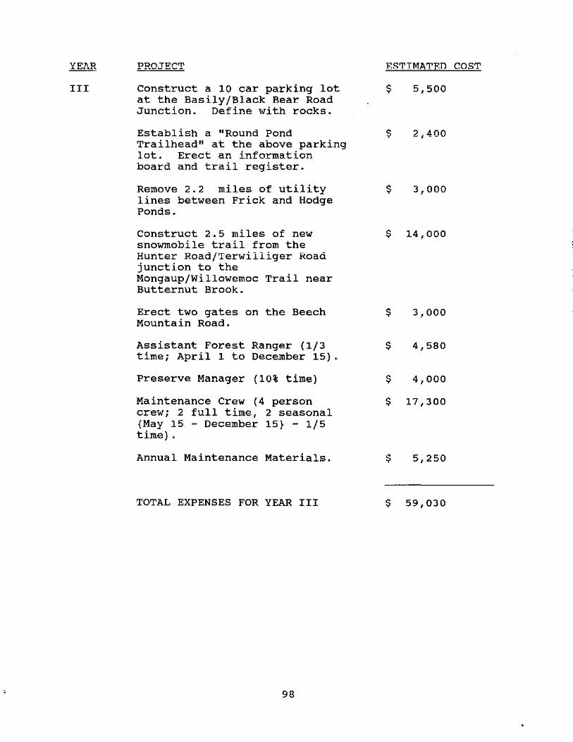
III
PROJECT
Construct a 10 car parking lot at the Basily/Black Bear Road Junction. Define with rocks.
Establish a "Round Pond Trailhead" at the above parking lot. Erect an information board and trail register.
Remove 2.2 miles of utility lines between Frick and Hodge Ponds.
Construct 2.5 miles of new snowmobile trail from the Hunter Road/Terwilliger Road junction to the Mongaup/Willowemoc Trail near Butternut Brook.
Erect two gates on the Beech Mountain Road.
Assistant Forest Ranger (1/3 time; April 1 to December 15).
Preserve Manager (10% time)
Maintenance Crew (4 person crew; 2 full time, 2 seasonal {May 15 - December 15} - 1/5 time) .
Annual Maintenance Materials.
TOTAL EXPENSES FOR YEAR III
98
ESTIN_ATF.D COST
$ 5,500
$ 2,400
$ 3,000
$ 14,000
$ 3,000
$ 4,580
$ 4,000
$ 17,300
$ 5,250
$ 59,030

IV
PROJECT
Construct a 10 car parking lot on the Shin Creek Road. Define with rocks.
Establish the above parking lot as the Shin Creek Trailhead. Erect an information board and trail register.
Construct 1.4 miles of multiple use trail from the Shin Creek Trailhead to the Frick Pond/Quick Lake Multiple Use Trail.
Improve the Mongaup Pond/Mongaup Creek snowmobile trail (5.7 miles).
Erect a gate where the Mongaup Pond/Mongaup Creek snowmobile trail meets Hunter Road.
Assistant Forest Ranger (1/3 time; April 1 to December 15).
Preserve Manager (10% Time)
Maintenance Crew (4 person crew; 2 full time, 2 seasonal {May 15 - December 15} - 1/5 time).
Annual Maintenance Materials.
TOTAL EXPENSES FOR YEAR IV
99
ESTIMATED COST
$ 6,000
$ 2,700
$ 8,700
$ 4,000
$ 1,500
$ 4,760
$ 4,250
$ 17,990
$ 5,510
$ 55,410

v
PROJECT
Rehabilitate the Parksville Road parking lot. Define with rocks.
Construct two 5-car parking lots on the Shin Creek Road. Define with rocks.
Erect a lean-to and outhouse on the ridge between Frick Pond and Quick Lake.
Construct 1.5 miles of multiple use trail and designate/mark an additional 1.6 miles of woods road as multiple use trail to create a 3.1 mile alternative route to Quick Lake.
Assistant Forest Ranger (1/3 time; April 1 to December 15).
Preserve Manager (10% time).
Maintenance Crew (4 person crew; 2 full time, 2 seasonal {May 15 - December 15} - 1/5 time).
Annual Maintenance Materials.
TOTAL EXPENSES FOR YEAR V
TOTAL ESTIMATED COST FOR 5-YEAR PLAN
100
$ 1,000
$ 7,000
$ 15,000
$ 8,500
$ 4,950
$ 4,500
$ 18,750
$ 5,790
$ 65,490
$ 613,500

VI. BIBLIOGRAPHY AND REFERENCES
Andrle, Robert F. and Janet R. Caroll. The Atlas of Breeding Birds in New York state. Cornell University Press, Ithaca, New York, 1988.
Bagdon Environmental Associates, Inc., Beech Mountain Resource Inventory Final Report, Delmar, New York, 1987.
Bagdon Environ~ental Associates, Inc., Beech Mountain Natural Significant Plant Habitat Survey Report, Delmar, New York, 1987.
Bagdon Environmental Associates, Inc., Rare Plant and Wildlife survey - Quick Lake Parcel, Preliminary Report, Delmar, New York, 1988.
Bagdon Environmental Associates, Inc., Winter Deer Concentration Area Survey - Beech Mountain, Delmar, New York, 1988.
Bennet, John and Seth Masia, Walks in the Catskills, Eastwoods Press, Inc., New York, 1974.
Chambers, Robert E., Integrating Timber and Wildlife Management, State University of New York College of Environmental Science and Forestry, Syracuse, New York, 1983.
Considine, Thomas and Thomas Frieswyk, Forest Statistics for New York, U.S.D.A~ Forest Service Resource Bulletin NE-71, 1982.
Evers, Alf. The Catskills - From Wilderness to Woodstock, 1972.
Ferguson, Roland and c. E. Mayer. The Timber Resources of New York, U.S.D.A. Forest Service Resource Bulletin NE-20, 1970.
Francis, Austin M., Catskill Rivers, Winchester Press, NJ, 1983.
Heidt, William, Frances J. Knapp's 103 Years, Sullivan County Historical Society, Jeffersonville, NY, 1956.
Hoffer, Audrey and Elizabeth Mikols, Unigue Natural Areas in the Catskill Region, Catskill Center for Conservation and Development, Inc., 1974.
Kudish, Michael, Ph.D. Catskill Soils and Forest History, Catskill Center for Conservation and Development, Inc., 1979.
Kudish, Michael, Ph.D., personal correspondence, May 20, 1990.
101

Kudish, Michael; Ph.D. VPqPt~tion~l Hi~tnry nf thP cat~kill Hiqh Peaks, state University of New York College of Environmental Science and Forestry, Ph.D., 1971.
Lueck, Thomas J., "Conservationists·Turn to Tough Tactics," The New York Times, February 26, 1989.
McAllister, Lee and Myron Steven Ochman, Hiking the Catskills, New York - New Jersey Trail Conference, 1989.
Myers III, Franklin Daniel, The Wood Chemical Industry in the Delaware Valley, Prior King Press, Middletown, NY, 1986.
New York state Department of Environmental Conservation. Balsam Lake Mountain Wild Forest Unit Management Plan, 1989.
New York State Department of Environmental Conservation. Beaverkill Public Campground Final Unit Management Plan, Division of Operations, Bureau of Recreation, Albany, New York, 1990.
New York State Department of Environmental Conservation. Catskill Park State Land Master Plan, 1985.
New York state Department of Environmental Conservation. Cultural Resources Investigation of the Beaverkill Public Campground, Town of Rockland. Sullivan County. New York. Bureau of Recreation, Division of Operations, July 30, 1990.
New York State Department of Environmental Conservation, Division of Fish and Wildlife - Information Resources Section. Natural Heritage Maps and Data, 1990.
New York State Department of Environmental Conservation, Division of Fish and Wildlife - Nongame Unit. Checklist of the Amphibians, Reptiles, Birds and Mammals of New York State, Including Their Protective Status, 1987.
New York State Department of Environmental Conservation. Trail Construction and Maintenance Manual, Division of Operations, "'nn"' .J..::1 O.G •
New York State Department of Environmental Conservation. Tree cutting Policy on Forest Preserve Lands, Organization and Delegation Memorandum #84-06, 1984.
New York State Office of Parks, Recreation and Historic Preservation, People, Resources, Recreation: 1988-1993 New York Statewide Comprehensive Outdoor Recreation Plan, Albany, New York, 1988.
102

New York State Office of Parks, Recreation and Historic Preservation, State of New York Snowmobile Trail Plan, Albany, New York, 1989.
Quinlan, James Eldridge, History of Sullivan County, Beebe and Morgans co., Liberty, NY, 1873.
Rich, John Lyon. Glacial Geology of the Catskills, New York State Museum Bulletin No. 299, December, 1934.
Temporary State Commission to Study the Catskills. Forest Resources of the Catskill Region, State University of New York, College of Environmental Science and Forestry, 1974.
Tiffany, Lena o. B., Pioneers of the Beaverkill Valley, Village Printer, Laurens, NY, 1976.
U.S.D.A. Soil Conservation Service, Soil survey of Sullivan County, New York, U.S. Government Printing Office, 1989.
U.S.D.A. Soil Conservation Service, Soil Survey of Ulster County, New York, 1979.
Wadsworth, Bruce, Guide to Catskill Trails, Adirondack Mountain Club, Inc., 1988.
Wakefield, Manville B., To the Mountains by Rail, Wakefair Press, Grahamsville, NY, 1990.
103

104

A P P E N D I C E S
105

106

14-16-2 (2/87)-7c 617.2'1
Appendix A State Environmental Quality Review
FULL ENVIRONMENTAL ASSESSMENT FORM
SEQR
Purpose: The foll EAF is designed to help applicants and agencies determine; in an orderly manner, whether a project or action may be significant. The question of whether an action may be significant is not always easy to answer. Frequently, there are aspects of a project that are subjective or unmeasureable. It is also understood that those who determine significance may have little or no formal knowledge of the environment or may be technically expert in environmental analysis. In addition, many who have knowledge in one particular area may not be aware of the broader concerns affecting the question of significance.
The full EAF is intended to provide a method whereby applicants and agencies can be assured that the determination process has been orderly, comprehensive in nature, yet flexible to allow introduction of information to fit a project or action.
Full EAF Components: The full EAF is comprised of three parts:
Part 1: Provides objective data and information about a given project and its site. By identifying basic project data, it assists a reviewer in the analysis that takes place in Parts 2 and 3.
Part 2: Focuses on identifying the range of possible impacts that may occur from a project or action. It provides guidance as to whether an impact is likely to be considered small to moderate or whether it is a potentiallylarge impact. The form also identifies whether an impact can be mitigated or reduced.
Part 3: If any impact in Part 2 is identified as potentially-large, then Part 3 is used to evaluate whether or not the impact is actually important. -
DETERMINATION OF SIGNIFICANCE-Type 1 and Unlisted Actions
Identify the Portions of EAF completed for this project: j8 Part 1 · g Part 2 DPart 3
Upon review of the information recorded on this EAF (Parts 1 and 2 and 3 if appropriate), and any other supporting information, and considering both the magitude and importance of each impact, it is reasonably determined by the lead agency that:
gj A. The project will not result in any large and important impact(s) and, therefore, is one which will not have a Significant impact on the environment, therefore a negative declaration will be prepared.
D B. Although the project could have a significant effect on the environment, there will not be a significant effect for this Unlisted Action because the mitigation measures described in PART 3 have been required, therefore a CONDITIONED negative declaration will be prepared.*
D C. The project may result in one or more large and important impacts that may have a significant impact on the environment, therefore a positive declaration will be prepared.
*A Conditioned Negative Declaration is only valid for Unlisted Actions
Willowemoc-Long Pond Wild Forest Unit Management Plan Name of Action
New York State Department of Environmental Conservation Name of Lead Agency
Frederick J. Regional r in Lead Agency
ead Agency
//1aroh 11'/I Date
107

11r•
PART 1-PROJECT INFORMATION
Prepared by Project Sponsor NOTICE: 1 his document is designed to assist in determining whether the action proposed may have a significant effect on the environment Please complete the entire form, Parts A through E. Answers to these questions will be considered as part of the application for approval and may be subject to further verification and public review. Provide any additional information you believe will be needed to complete Parts 2 and 3.
It is expected that completion of the full EAF will be dependent on information currently available and will not involve new studies, research or investigation. If information requiring such additional work is unavailable, so indicate and specify each instance.
NAME OF ACTION
Application of the Willowemoc-Long Pond Wild Forest Unit Management Plan LOCATION OF ACTION (Include Street Address, Municipality and County)
NAME OF APPLICANT/SPONSOR
NYS Department of Environmental Conservation Region 3 BUSINESS TELEPHONE
(914 ) 2 5 5- 5 4 5 3 ADDRESS
21 South Putt Corners Road CITY/PO
New Paltz NAME OF OWNER (If different)
ADDRESS
CITY/PO
DESCRIPTION OF ACTION
STATE
NY ZIP CODE
12561 BUSINESS TELEPHONE
(
STATE ZIP CODE
Implementation of the Willowemoc-Long Pond Wild Forest Unit Management Plan - see plan for proposed management projects.
Please Complete Each Question- lndkate N.A. if not applicable
A. Site Description Physical setting of overall project, both developed and undeveloped areas.
1. Present land use: OUrban 0 Industrial OCommercial DResidential (suburban) ORural (non-farm)
~Forest OAgriculture DOther ----------------------
2. Total acreage of project area: _1_4_,_8_7_0 ___ acres.
APPROXIMATE ACREAGE Meadow or Brushland (Non-agricultural)
Forested
Agricultural (Includes orchards, cropland, pasture, etc.)
Wetland (Freshwater or tidal as per Articles 24, 25 of ECL)
Water Surface Area
Unvegetated (Rock, earth or fill)
Roads, buildings and other paved surfaces Other (Indicate type) _____________ _
50 14,352
0 413
55
PRESENTLY AFTER COMPLETIOt'~ acres 50 acres
acres 14,351.3 acres
acres 0 acres
acres 413
acres
acres 55 acres
acres .7 acres
acres acres
acres acres
3. What is predominant soil type(s) on project site? Willowemoc-Mongaup=Lew Beach Association a. Soil drainage: OWell drained 70 % of site OModerately well drained 27 % of site
0 Poorly drained 3 % of site
b. If any agricultural land is involved, how many acres of soil are classified within soil group 1 through 4 of the NYS Land Classific-ation System? acres. (See 1 NYCRR 370).
4. Are there bedrock outcroppings on project site? G:JYes ONo
a. What is depth to bedrock? 0 - > 5 (in feet)
10'8

1
r !
&
5. Approximate percentage of proposed project site with slopes: 00-10% __ l_O __ % 010-15% __ 3_0 __ %
015% or greater 60 %
6. Is project substantially contiguous to, or contain a building, site, or district, listed on the State or the National Registers of Historic Places? OYes QNo
7. Is project substantially contiguous to a site listed on the Register of National Natural Landmarks? OYes 0No
8. What is the depth of the water table? l. 5-6 + (in feet)
9. Is site located over a primary, principal, or sole source aquifer? OYes 0No
10. Do hunting, fishing or shell fishing opportunities presently exist in the project area? GYes ONo
11. Does project site contain any species of plant or animal life that is identified as threatened or endangered?
OYes ~No According to New York Natural Heritage Program Maps and Data
Identify each species
12. Are there any unique or unusual land forms on the project site? (i.e., cliffs, dunes, other geological formations)
OYes IXJNo Describe
13. Is the project site presently used by the community or neighborhood as an open space or recreation area?
14.
15.
:&:JYes ONo If yes, explain it is public land with bikin~ and snowmobile trails
Does the present site include scenic views known to be important to the community? OYes G(]No Willowernoc Creek, Conklin Brook Fall Brook, Flat Brook
Streams within or contiguous to project area: Shin Creek, Gee Brook, Mongaup Creek, Butterut Brook, lh.r Srook
a. Name of Stream and name of River to which it is tributary ~De .......... l .... a1,,...r._.a ..... r""'e'--'-'R._.j_,,vu;;e::..r ________ _
16. Lakes, ponds, wetland areas within or contiguous to project area: and 17 wetlands
a. Name Waneta Lake,Quick lake, Frick Pond,,Long Pon~. Size (In acres) 468 (total)
17. Is the site served by existing public utilities? g]Yes ONo
a) If Yes, does sufficient capacity exist to allow connection? DYes ONo N/A
b) If Yes, will improvements be necessary to allow connection? OYes ONo N/A
18. Is the site located in an agricultural district certified pursuant to Agriculture and Markets Law, Article 25-AA, Section 303 and 304? OYes 0No
19. Is the site located in or substantially contiguous to a Critical Environmental Area designated pursuant to Article 8 of the ECL, and 6 NYCRR 617? OYes [XNo
20. Has the site ever been used for the disposal of solid or hazardous wastes? DY es QNo
B. Project Description 1. Physical dimensions and scale of project (fill in dimensions as appropriate)
a. Total contiguous acreage owned or controlled by project sponsor _1_4_,_8_7_0 __ acres.
b. Project acreage to be developed: _O • 7 acres initially; 0 .] acres ultimately.
c. Project acreage to remain undeveloped 14, 869 .-3- acres.
d. Length of project, in miles: N/A (If appropriate)
e. If the project is an expansion, indicate percent of expansion proposed %;
f. Number of off-street parking spaces existing J 4 ; proposed __,6..,_9,,__ __ _
g. Maximum vehicular trips generated per hour N/A (upon completion of project)?
h. If residential: Number and type of housing units: One Family Two Family Multiple Family Condominium
Initially
Ultimately
i. Dimensions (in feet) of largest proposed structure 8 height; 8 width; 12
j. Linear feet of frontage along a public thoroughfare project will occupy is? N/A ft. 109
length. (t!!.f\tJTo)

i i
%
2. How much natural material (i.e., rock, earth, etc.) will be removed from the site? ----'"-----tons/cubic yards
3. Will disturbed areas be reclaimed? DY es ONo ~N/A
a. !f yes, for what intended purpose is the site being reclaimed?------------------
b. Will topsoil be stockpiled for reclamation? OYes ONo
c. Will upper subsoil be stockpiled for reclamation? DY es ONo
4. How many acres of vegetation (trees, shrubs, ground covers) will be removed from site? 0 acres.
5. Will any mature forest (over 100 years old) or other locally-important vegetation be removed by this project? DY es Ga No
6. If single phase project: Anticipated period of construction _____ months, (including demolition).
7. If multi-phased:
a. Total number of phases anticipated -~5 ___ (number).
b. Anticipated date of commencement phase 1 9 month --"9'""1.._ __ year, (including demolition).
c. Approximate completion date of fin al phase _ _,..._ ___ month _ _,9~6a---- year.
d. Is phase 1 functionally dependent on subsequent phases? QYes ONo
8. Will blasting occur during construction? OYes []No
9. Number of jobs generated: during construction--""'----; after project is complete-----="...__
10. Number of jobs eliminated by this project--~--
11. Will project require relocation of any projects or facilities? DY es .!{]No If yes, explain ------
12. Is surface liquid waste disposal involved? DY es ~o
a. If yes, indicate type of waste (sewage, industrial, etc.) and amount -----------------
b. Name of water body into which effluent will be discharged --------------~----
13. Is subsurface liquid waste disposal involved? OYes ~No Type----------------
14. Will surface area of an existing water body increase or decrease by proposal? DYes 29No
Explain Waneta Lake Darn Rehabilitation will not resuJ t in a change in 1 ake' s snrface area 15. Is project or any portion of project located in a 100 year flood plain? fJYes ONo
16. Will the project generate solid waste? DY es ~No
a. If yes, what is the amount per month ----- tons
b. If yes, will an existing solid waste facility be used? DYes . ONo
c. If yes, give name ________________ ;location
d. Will any wastes not go into a sewage disposal system or into a sanitary landfill? DY es ONo
e. If Yes, explain
17. Will the project involve the disposal of solid waste? OYes £]No
a. If yes, what is the anticipated rate of disposal? ----- tons/month.
b. If yes, what is the anticipated site life? _____ years.
18. Will project use herbicides or pesticides? DY es !X]No
19. Will project routinely produce odors (more than one hour per day)? OYes :J;)No
20. Will project produce operating noise exceeding the local ambient noise levels? DY es Ba No
21. Will project result in an increase in energy use? DY es KJNo
If yes, indicate type(s) ------------------------------------
22. If water supply is from wells, indicate pumping capacity _____ gallons/minute.
23. Total anticipat~d water usage per day gallons/day.
24. Does project involve Local, State or Federal funding? BaYes ONo
If Yes, explain _ _..,..,i;-.....~a.t.------------------------'-------------
110·

I i I ~
25. Approvals Required: Type
Submittal Date
City, Town, Villag';; Board DY es DNo
City, Town, Village Planning Board DY es DNo
City, Town Zoning Board DY es ONo
City, County Health Department DY es DNo
Other Local Agencies DY es ONo
Other Regional Agencies DY es ONo
State Agencies IXl Yes DNo DEC
Federal Agencies DY es ONo
C. Zoning and Planning Information 1 . Does proposed action involve a planning or zoning decision?
' If Yes, indicate decision required:
Commissioner
k]Yes ONo
Dzoning amendment Dzoning variance Ospecial use permit Dsubdivision Dsite plan
Dnew/revision of master plan ~resource management plan Dother --------------
2. What is the zoning classification(s)of the site? _W_i_l_d __ F_o_r_e_s_t ___________________ _
3. What is the maximum potential development of the site if developed as permitted by the present zoning?
N/A
4. What is the proposed zoning of the site? --:.W"""i=-=l=d:::..-.:F=-o=-r=-e=-s=t _____________________ _
5. What is the maximum potential developmept of the site if developed as permitted by the proposed zoning?
N/A
6. Is the proposed action consistent with the recommended uses in adopted local land use plans? N/ A DYes DNo
7. What are the predominant land use(s) and zoning classifications within a 1.4 mile radius of proposed action?
N/A
8. Is the proposed action compatible with adjoining/surrounding land uses within a 1.4 mile? CXYes ONo
9. If the proposed action is the subdivision of land, how many lots are proposed? ------------
a. What is the minimum lot size proposed? -------------------------
10. Will proposed action require any authorization(s) for the formation of sewer or water districts? DYes Kl No
11 . Will the proposed action create a demand for any community provided services (recreation, education, police,
fire protection)? DYes [lNo
a. If yes, is existing capacity sufficient to handle projected demand? DYes DNo
12. Will the proposed action result in the generation of traffic significantly above present levels? DYes [JjjNo
.. a. If yes, is the existing road network adequate to handle the additional traffic? OYes DNo I
•· D. Informational Details
Attach any additional information as may be needed to clarify your project. If there are or may be any adverse impacts associated with your proposal, please discuss such impacts and the measures which you propose to mitigate or
avoid them.
E. Verification I certify that the information provided above is true to the best of my knowledge.
Appl icant/Spon --=...:W.=.i.=.ll=..1=..· am:::;.:..:.--=R:.:.:u::..::d::..::g'-=e'----------------- Date _3_· ,,_/_z_.1-+/_1..ul.__ __ _ tV
_.$lM!t!t!:.~4_,~~~~=-------- Title Sr. Forester Signature
If the action is in the Coa tal Area, and you are a state agency, complete the Coastal Assessment Form before proceeding
with this assessment. 1. 1 1

Part 2-PROJECT IMPACTS AND THEIR MAGNITUDE Responsibility of Lead Agency
Generai Information (Read Carefully) • In completing the form the reviewer should be guided by the question: Have my responses and determinations been
reasonable? The reviewer is not expected to be an expert environmental analyst.
• identifying that an impact will be potentially large (column 2) does not meao that it is also necessarily significant. Any large impact must be evaluated in PART 3 to determine significance. Identifying an impact in coiurnn 2 simply asks that it·be looked at further.
• The Examples provided are to assist the reviewer by showing types of impacts and wherever possible the threshold of magnitude that would trigger a response in column 2. The examples are generally applicable throughout the State and for most situations. But, for any specific project or site other examples and/or lower thresholds may be appropriate for a Potential Large Impact response, thus requiring evaluation in Part 3.
• The impacts of each project, on each site, in each locality, will vary. Therefore, the examples are illustrative and have been offered as guidance. They do not constitute an exhaustive list of impacts and thresholds to answer each question.
• The number of examples per question does not indicate the importance of each question.
• In identifying impacts, consider long term, short term and cumlative effects.
Instructions (Read carefully) a. Answer each of the 19 questions in PART 2. Answer Yes if there wiii be any impact.
b. Maybe answers should be considered as Yes answers.
c. If answering Yes to a question then check the appropriate box (column 1 or 2) to indicate the potential size of the impact. If impact threshold equals or exceeds any example provided, check column 2. If impact will occur but threshold is lower than example, check column 1.
d. If reviewer has doubt about size of the impact then consider the impact as potentially large and proceed to PART 3.
e. If a potentially large impact checked in column 2 can be mitigated by change(s) in the project to a small to moderate impact, also check the Yes box in column 3. A No response indicates that such a reduction is not possible. This must be explained in Part 3.
IMPACT ON LAND 1. Will the proposed action result in a physical change to the project site?
ONO ~YES Examples that would apply to column 2
• Any construction on slopes of 15% or greater, (15 foot rise per 100 foot of length), or where the general slopes in the project area exceed 10%.
• Construction on land where the depth to the water table is less than .'.\ feet.
• Construction of paved parking area for 1,000 or more vehicles.
° Construction on land where bedrock is exposed or generally within 3 feet of existing ground surface.
"' Construction that will continue for more than 1 year or involve more than one phase or stage.
• Excavation for mining purposes that would remove more than 1,000 tons of natural material (i.e., rock or soil) per year.
• Construction or expansion of a sanitary landfill.
• Construction in a designated floodway.
• Other impacts 10 9 mj Jes of r.·,_,w trail construction, 6 parking lots totaling 0.7 acres
2 Will there be an effect to any unique or unusual land forms found on the site? (i.e., cliffs, dunes, geological formations, etc.)ooNO DYES
• Specific land forms:
112
1 Small to Moderate
Impact
D
n L...J
LJ D
D
D
D D XJ
D
2 Potential
Large Impact
D
D
u D
D
D
D D D
D
3 Can Impact Be
Mitigated By Project Change
DY es
DY es
,......,_, UYes
DY es
DY es
DY es
DY es
DY es
DY es
1
0Yes
DNo
DNo
,-,., LJ l'!O
DNo
ONo
DNo
0No
0No
DNo
ONc

(
L
l l
IMPACT ON WATER 3. Will proposed action affect any water body designated as protected?
(Under Articles 15, 24, 25 of the Environmental Conservation Law, ECL) CXNO DYES
Examples that would apply to column 2 o Developable area of site contains a protected water body.
• Dredging more than 100 cubic yards of material from channel of a protected stream.
• Extension of utility distribution facilities through a protected water body.
• Construction in a designated freshwater or tidal wetland.
• Other impacts: ~------------------~
4. Will proposed action affect any non-protected existing or new body of water? ONO QYES Examples that would apply to column 2
• A 10% increase or decrease in the surface area of any body of water or more than a 10 acre increase or decrease.
• Construction of a body of water that exceeds 10 acres of surface area.
• Other impacts: Rehab. of the darn at Waneta Lake will necessitate a temporary reduction in water level/
surface area 5. Will Proposed Actton affect surface or groundwater
quality or quantity? ~NO DYES Examples that would apply to column 2
• Proposed Action will require a discharge permit.
• Proposed Action requires use of a source of water that does not have approval to serve proposed (project) action.
• Proposed Action requires water supply from wells with greater than 45 gallons per minute pumping capacity.
• Construction or operation causing any contamination of a water supply system.
• Proposed Action will adversely affect groundwater. • Liquid effluent will be conveyed off the site to facilities which presently
do not exist or have inadequate capacity.
• Proposed Action would use water in excess of 20,000 gallons per day.
• Proposed Action will likely cause siltation or other discharge into an existing body of water to the extent that there will be an obvious visual contrast to natural conditions.
• Proposed Action will require the storage of petroleum or chemical products greater than 1,100 gallons.
• Proposed Action will allow residential uses in areas without water and/or sewer services.
• Proposed Action locates commercial and/or industrial uses which may require new or expansion of existing waste treatment and/or storage facilities.
• Other impacts: ___________________ _
6. Will proposed action alter drainage flow or patterns, or surface water runoff? XJNO DYES Examples that would apply to column 2
• Proposed Action would change flood water flows.
113
1 Small to Moderate
Impact
D
D
D
D
D
D
D
~
D
D
D
D
D D
D
D
D
D
D
D
D
2 Can lm;act Be I Potential
Large Mitigated By Impact Project Change
I D DY es DNo
D DY es DNo
D DY es DNo
D DY es DNo
D DYes DNo
D 0Yes DNo I
D DY es 0No
D DYes DNo I I
D 0Yes DNo
D 0Yes DNo
D 0Yes DNo
D 0Yes DNo
D 0Yes DNo D 0Yes 0No
D 0Yes 0No
D 0Yes 0No
D 0Yes 0No
D DY es DNo
D DY es 0No
D DY es 0No
l
D DY es 0No !
0 Proposed Action may cause substantial erosion.
• Proposed Ac.tion is incompatible with existing drainage patterns.
• Proposed Action will allow development in a designated floodway.
• Other impacts: --------------------
IMPACT ON AIR
7. Will proposed action affect air quality? OONO DYES Examples that would apply to column 2
• Proposed Action will induce 1,000 or more vehicle trips in any given hour.
e Proposed Action will result in the incineration of more than i ton of refuse per hour.
0 Emission rate of total contaminants will exceed 5 lbs. per hour or a heat source producing more than 10 million BTU's per hour.
• Proposed action will allow an increase in the amount of land committed to industrial use.
• Proposed action will allow an increase in the density of industrial development within existing industrial areas.
• Other impacts: --------------------
IMPACT ON' PLANTS AND ANIMALS
8. Will Proposed Action affect any threatened or endangered species? 1'6JNO DYES Examples that would apply to column 2
• Reduction of one or more species listed on the New York or Federal list, using the site, over or near site or found on the site.
e Removal of any portion of a critical or significant wildlife habitat.
• Application of pesticide or herbicide more than .twice a year, other than for agricultural purposes.
e Other impacts: ___________________ _
9. Will Proposed Action substantially affect non-threatened or non-endangered species? ~NO DYES Examples that wouid appiy to column 2
• Proposed Action would substantially interfere with any resident or migratory fish, shellfish or wildlife species.
• Proposed Action requires the removal of more than 10 acres of mature forest (over 100 years of age) or other locally important vegetation.
IMPACT ON AGRICULTURAL LAND RESOURCES
10. Will the Proposed Action affect agricultural land resources? ®NO DYES
Examples that wo"uld apply to column 2 • The proposed action would sever, cross or limit access to agricultural
land (includes cropland, hayfields, pasture, vi~eyard, orchard, etc.)
114
1 Small to Moderate
Impact
D
D
D
D
D
n L...J
D
D
D
D
D
D
D
D
D
D
D
2 3 Potential Can Impact Be
Large Mitigated By Impact Project Change
D DY es 0No
D DY es 0No
D DY es 0No
D DY es 0No
D DY es 0No
I n 0Yes 0No I
D DY es 0No
D DY es 0No
D DY es 0No
D DY es 0No
D DY es DNo
D DYes 0No
D DY es DNo
D I DYes
D 0Yes DNo
D DY es DNo
D 0Yes

• Construction activity would excavate or compact the soil profile of agricultural land.
• The proposed action would irreversibly convert more than 10 acres of agricultural land or, if located in an Agricultutal District, more than 2.5 acres of agricultural land.
• The proposed action would disrupt or prevent installation of agricultural land management systems (e.g., subsurface drain lines, outlet ditches, strip cropping); or create a need for such measures (e.g. cause a farm field to drain poorly due to increased runoff)
• Other impacts: --------------------
IMPACT ON AESTHETIC RESOURCES 11. Will proposed action affect aesthetic resources? IXJNO DYES
(If necessary, use the Visual EAF Addendum in Section 617.21, Appendix B.) Examples that would apply to column 2
• Proposed land uses, or project components obviously different from or in sharp contrast to current surrounding land use patterns, whether man-made or natural.
• Proposed land uses, or project components visible to users of aesthetic resources which will eliminate or significantly reduce their enjoyment of the aesthetic qualities of that resource.
• Project components that will result in the elimination or significant screening of scenic views known to be important to the area.
• Other impacts: --------------------
IMPACT ON HISTORIC ANO ARCHAEOLOGICAL RESOURCES 12. Will Proposed Action impact any site or structure of historic, pre-
historic or paleontological importance? ONO QYES Examples that would apply to column 2
• Proposed Action occurring wholly or partially within or substantially contiguous to any facility or site listed on the State or National Register of historic places.
• Any impact to an archaeological site or fossil bed located within the project site.
• Proposed Action will occur in an area designated as sensitive for archaeological sites on the NYS Site Inventory.
• Other impacts: ___________________ _
IMPACT ON OPEN SPACE ANO RECREATION 13. Will Proposed Action affect the quantity or quality of existing or
future open spaces or recreational opportunities? Examples that would apply to column 2 ONO GaYES
• The permanent foreclosure of a future recreational opportunity. "' A major reduction of an open space important to the community.
• Other impacts: The project will result in an increase in recreational opportunities (30 miles of recreatio trails) 115
1 Small to Moderate
Impact
D
D
D
D
D
D
D
D
D
D
6'J
D
D D
~ , 1-·-
2 3 :
Potential Can Impact Be Large Mitigated By
Impact Project Change
D DY es DNo
I D DY es 0No
D DY es DNo
D DY es 0No
I
D DYes DNo
D DY es 0No
D DYes DNo
D DY es 0No
D DY es 0No
D DY es 0No
D 0Yes 0No
D DY es DNo
D DY es DNo
D DY es DNo
D DY es DNo

IMPACT ON TRANSPORTATION
14. Will there be an effect to existing transportation systems? :k]NO DYES
Examples that would apply to column 2
"' Alteration of present patterns of movement of people and/or goods.
" Proposed Action will result in major traffic problems.
•Other impacts:---------
IMPACT ON ENERGY
15. Will proposed action affect the community's sources of fuel or energy supply? IXJNO DYES Examples that would apply to column 2
• Proposed Action will cause a greater than 5% increase in the use of any form of energy in the municipality.
• Proposed Action will require the creation or extension of an energy transmission or supply system to seive mo;e than 50 single or two family residences or to serve a major commercial or industrial use.
•Other impacts:-----------------------
NOISE AND ODOR IMPACTS
16. Will there be objectionable odors, noise, of the Proposed Action?
or vibration as a result ONO IXJYES
Examples that would apply to column 2
• Blasting within 1,500 feet of a hospital, school or other sensitive facility.
• Odors will occur routinely (more than one hour per day).
• Proposed Action will produce operating noise exceeding the local ambient noise levels for noise outside of structures.
• Proposed Action will remove natural barriers that would act as a noise screen.
• Other impacts: Snowmobiles groudce noise which may adversely affect wildlife as well as other forms of recreation (X-C skiers) ·
IMPACT ON PUBLIC HEAL TH
17. Will Proposed Action affect public health and safety? fJNO
Examples that would apply to column 2 DYES
• Proposed Action may cause a risk of explosion or release of hazardous substances (i.e. oil, pesticides, chemicals, radiation, etc.) in the event of accident or upset conditions, or there may be a chronic low level discharge or emission.
" Proposed Action may result in the burial of "hazardous wastes" in any form (i.e. toxic, poisonous, highly reactive, radioactive, irritating, infectious, etc.)
• Storage facilities for one million or more gallons of liquified natural gas or other flammable liquids.
• Proposed action may result in the excavation or other disturbance within 2,000 feet of a site used for the disposal of solid or hazardous waste.
• Other impacts: --------------------~
116
I
1 2 3 Small to Potential Can Impact Be Moderate Large Mitigated By
impact impact Project Change
0 0 DY es 0No
0 0 DYes ONo
0 0 0Yes 0No
0 0 DY es ONo
0 0 I 0Yes ONo I
0 0 DY es ONo I
0 0 0Yes DNo
0 0 0Yes 0No
0 0 DY es DNo
0 D DY es ONo
g 0 0Yes ONo
I I
0 0 DY es ONo
0 0 DY es ONo
0 0 DYes DNo
0 0 DY es ONO
0 0 DY es 0No

IMPACT ON GROWTH AND CHARACTER OF COMMUNITY OR NEIGHBORHOOD
18 Will proposed action affect the character of the existing community? ~NO DYES
Examples that would apply to column 2
• The permanent population of the city, town or village in which the project is located is likely to grow by more than 5%.
• The municipal budget for capital expenditures or operating services will increase by more than 5% per year as a result of this project.
• Proposed action will conflict with officially adopted plans or goals.
• Proposed action will cause a change in the density of land use.
1 Small to Moderate
Impact
n
0
0
0
2 3 Potential Can Impact Be
Large Mitigated By Impact Project Change
0 DY es ONo
0 DY es ONo
0 DY es 0No
0 DY es DNo
... • Proposed Action will replace or eliminate existing facilities, structures 0 0 DY es ONo
" I
or areas of historic importance to the community.
• Development will create a demand for additional community services 0 0 DY es (e.g. schools, police and fire, etc.)
• Proposed Action will set an important precedent for future projects. 0 0 DYes
• Proposed Action will ~ar eliFl'liAat-e employment. ~ 0 DYes • Other impacts: ___________________ _ 0 0 DY es
19. Is there, or is there likely to be, public controversy related to potential adverse environmental impacts? ~NO DYES
If Any Action in Part 2 Is Identified as a Potential Large Impact or If You Cannot Determine the Magnitude of Impact, Proceed to Part 3
Part 3-EVALUATION OF THE IMPORTANCE OF IMPACTS Responsibility of Lead Agency
ONo
ONo
0No
ONo
Part 3 must be prepared if one or more impact(s) is considered to be potentially large, even if the impact(s) may be mitigated. ·
Instruct ions Discuss the following for each impact identified in Column 2 of Part 2:
1 . Briefly describe the impact.
2. Describe (if applicable) how the impact could be mitigated or reduced to a small to moderate impact by project change(s).
3. Based on the information available, decide if it is reasonable to conclude that this impact is important.
To answer the question of importance, consider: • The probability of the impact occurring • The duration of the impact • Its irreversibility, including permanently lost resources of value • Whether the impact can or will be controlled • The regional consequence of the impact • Its potential divergence from local needs and goals • Whether known objections to the project relate to this impact.
(Continue on attachments)
117

14-12-7 (2187)-9c
517.21 ID#N3-00213- 00042 Appendix F
State Environmental Quality Review
NEGATIVE DECLARATION Notice of Determination of Non-Significance
SEQR
Project Number -------- Date--------
This notice is issued pursuant to Part 617 of the implementing regulations pertaining to Article 8 (State Environmental Quality Review Act) of the Environmental Conservation Law.
The New York State Department of Environmental Conservation , as lead. agency, has determined that the proposed action described below will not have a significant effect on the environment and a Draft Environmental Impact Statement will not be prepared.
Name of Action: Implementation of the Willowemoc - Long Pond Wild Forest Unit Management Plan
SEQR Status: Type I IBJ Unlisted D
Conditioned Negative Declaration:
Description of Action:
DYes lfil No
The plan identifies the various resources of the 14,870 acre Willowemoc-Long Pond Wild Forest, a part of the Catskill Forest Preserve. It also identifies the constraints and issues affecting the area, and developes a series of goals and objectives which will govern the area's future management. Specific projects proposed to fulfill these goals and objectives include the construction of six small unpaved parking lots and 10.9 mile of new snowmobile and horse trails. An additional 20.3 miles of existing wood roads will be designated and marked for recreational use. (12.4 miles for hiking, 7.6 miles for snowmobiling and 1.9 miles for horseback riding). 19.2 miles of existing recreational trails will be maintained. The plan will direct all management activities within the unit for a period of five years from the date of adoption.
Location: (Include street address and the name of the municipality/county. A location map of appropriate scale is also recommended.)
Sullivan County Towns of Rockland and Neversink, Ulster County Towns of Hardenburgh and Denning. New York State Forest Preserve lands designated as the WillowemocLong Pond Wild Forest.
118

SEQR Negative Declaration Page 2
~easons Supporting This Determi~ation: . . . . . . \ (See 617.6(g) for requirements of this determination; see 617.S(h) for Cond1t1oned Negative Declarat1on) . i
The area will be managed in accordance with the Wild Forest Guidelines established in the Catskill Park State Land Master Plan as well as the constraints set forth in Articl XIV of the New York State Constitution and Section 9 of the Environmental Conservaticri\ ~w. I The Commissioner's Organization and Delegation Memorandum #84-06 regarding tree cutting on Forest Preserve lands will be strictly adhered to when proposed trails and parking lots are constructed. Deer wintering areas have been identified within the unit and all new snowmobile trails have been routed to avoid these areas. However, the Department will monitor winter conditions and in the event of a severe winter the snowmobile trails within the unit wi 1 be closed for as long as the Regional Wildlife Manager determines is necessary. All trails and parking lots proposed have been sited to avoid the wetlands identified within the unit. Prior to any site disturbance, an archaeological investigation will b undertaken in areas identified by the NYS Archaeological Site Locations Map. Culverts, waterbars, switchbacks and drainage ditches will be utilized in both new trail construction and existing trail maintenance to mitigate soil erosion and compaction. Multiple use trails will be closed to horseback riders and mountain bike riders during wet, muddy conditions (typically in the spring) when the potential for erosion is sever Parking lot construction will be minor (less than 1/2 acre total). They are intended to provide safe and appropriate access to public land. Information boards will be erected at trailhead parking lots to convey the rules and regulations governing the use of forest preserve land and to instruct users in techniques for minimum impact camping, proper human sanitation, precautions concerning Lyme disease and Giardia, etc.*
If Conditioned Negative Declaratlon, provide on attachment the specific mitigation measures imposed.
For Further Information:
Contact Person: William Rudge, Sr. Forester
Address: 21 South Putt Corners Rd., New Paltz, NY 12561
Telephone Number:914-255-5453
For Type I Actions and Conditioned Negative Declarations, a Copy of this Notice Sent to:
Commissioner, Department of Environmental Conservation, 50 Wolf Road, Albany, New York 12233-0001
Appropriate Regional Office of the Department of Environmental Conservation
Office of the Chief Executive Officer of the political subdivision in which the action will be principally located.
Applicant (if any)
Other involved agencies (if any)
*The Waneta Lake Dam Rehabilitationvvas previously assessed and determined not to have a significant adverse environmental impact on 8-20-90.
119

APPENDIX B - WILDLIFEe
Appendix B-1. Status and occurrence of New York amphibians in the Willowemoc - Long Pond Wild Forest, a part of the Delaware Hills and Catskill Peaks subzones, as listed in "Integrating Timber and Wildlife Management Handbook" {Chambers, 1983).
SPECIES STATUS in NY
Jefferson Salamander Special Concern
Blue-Spotted Salamander Special Concern
Spotted Salamander Special Concern
Red-spotted Newt
Dusky Salamander
Mountain Dusky Salamander
Redback Salamander
Slimy Salamander
Four-toed Salamander
Spring Salamander
Red Salamander
Two-lined Salamander
Longtail Salamander
American Toad
Fowler's Toad
Spring Peeper
Gray Treefrog
Bullfrog Game Species
Green Frog Game Species
Wood Frog Game Species
Pickerel Frog Game Species
120
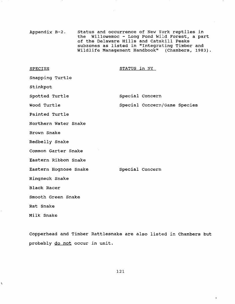
Appendix B-2. Status and occurrence of New York reptiles in the Willowemoc - Long Pond Wild Forest, a part of the Delaware Hills and Catskill Peaks subzones as listed in "Integrating Timber and Wildlife Management Handbook" (Chambers, 1983).
SPECIES
Snapping Turtle
stinkpot
Spotted Turtle
Wood Turtle
Painted Turtle
Northern Water Snake
Brown Snake
Redbelly Snake
Common Garter Snake
Eastern Ribbon Snake
Eastern Hognose Snake
Ringneck Snake
Black Racer
Smooth Green Snake
Rat Snake
Milk Snake
STATUS in NY
Special Concern
Special Concern/Game Species
Special Concern
Copperhead and Timber Rattlesnake are also listed in Chambers but
probably do not occur in unit.
121

. -'
I-' N N
'"
Appendix B-3. StatuE; and occurrence o:f bree<;ling birds as listed in the 11Atlas of Breeding Birds in New York State" (Andrle and Carroll, 1988)
PAGE 1 " , . 4N THE WILLOWEMOC - LONG POND WILD FOREST 1980-1985 DATA - AOU CHECKLIST ORDER
NATURAL COMMON NAME SCIENTIFIC NAME NEW YORK HERITAGE
LEGAL PROGRAM STATUS STATE RANK
CONFIRMED BREEDERS
Wood Duck Aix sponsa Game Speciies SS Mallard Anas platyrhynchos Game Species SS Common Merganser Mergus merganser Game Speci1es SS Red-shouldered Hawk Buteo lineatus Threatened S4 Broad-winged Hawk Buteo platypterus Protected SS Red-tailed Hawk Buteo jamaicensis Protected SS Ruffed Grouse Bonasa umbellus Game Speci1es SS Wild Turkey Meleagris gallopavo Game Species SS Ame!rican Crow Corvus brachyrhynchos Game Speciies SS Killdeer Charadrius vociferus Protected SS Spotted Sandpiper Actitis rnacularia Protected SS American Woodcock Sccilopax minor Game Species SS Rock Dove Columba livia Unprotected. SE Mourning Dove Zenaida rnacroura Protected SS Black-billed Cuckoo Coccyzus erythropthalrnus Protected SS Chimney Swift Chaetura pelagica Protected SS Ruby-throated Hummingbird Archilochus colubris Protected SS Belted Kingfisher Ceryle alcyon Protected SS Yellow-bellied Sapsucker Sphyrapicus varius Protected SS Dmmy Woodpecker Pic:oides pubescens Protected SS Hairy Woodpecker Picoides villosus Protected SS Northern Flicker Colaptes auratus Protected SS Pileated Woodpecker Dryocopus pileatus Protected SS Olive-sided Flycatcher Contopus borealis Protected SS Eastern Wood-Pewee Contopus virens Protected SS Least Flycatcher Ernpidonax minimus Protected SS Eastern Phoebe Sayornis phoebe Protected SS Eastern Kingbird Tyrannus tyrannus Protected SS Tn!e Swallow Tachycineta bicolor Protected SS Bank Swallow Riparia riparia Protected SS

PAGE 2
COMMON NAME
Cliff Swallow Barn Swallow Blue Jay Common Raven Black-capped Chickadee Red-breasted Nuthatch White-breasted Nuthatch House Wren Winter Wren Golden-crowned Kinglet
...... Eastern Bluebird NVeery u: Hermit Thrush
Wood Thrush American Robin Gray Catbird Cedar Waxwing European Starling Solitary Vireo Yellow-throated Vireo Red-eyed Vireo Yellow Warbler Chestnut-sided Warbler Magnolia Warbler Black-throated Blue Warbler Yellow-rumped Warbler Black-throated Green Warbler Blackburnian Warbler Black-and-white Warbler American Redstart Ovenbird Northern Waterthrush
• Louisiana Waterthrush
BREEDING SPECIES OF : WILLOWEMOC - LONG POND WILD FOREST 1980-198S DATA - AOU CHECKLIST ORDER
SCIENTIFIC NAME
Hirundo pyrrhonota Hirundo rustica Cyanocitta cristata Corvus corax Parus atricapillus Sitta canadensis Sitta carolinensis Troglodytes aedon Troglodytes troglodytes Regulus satrapa Sialia sialis Catharus fuscescens Catharus guttatus Hylocichla mustelina Turdus migratorius Dumetella carolinensis Bombycilla cedrorum Sturnus vulgaris Vireo solitarius Vireo flavifrons Vireo olivaceus Dendroica petechia Dendroica pensylvanica Dendroica magnolia Dendroica caerulescens Dendroica coronata Dendroica virens Dendro.ica fusca Mniotilta varia Setophaga ruticilla Seiurus aurocapillus Seiurus noveboracensis Seiurus motacilla
NATURAL NEW YORK HERITAGE LEGAL PROGRAM STATUS STATE RANK
Protected SS Protected SS Protected SS Protected-Special Concern S4 Protected SS Protected SS Protected SS Protected SS Protected SS Protected SS Protected-Special Concern SS Protected SS Protected SS Protected SS Protected SS Protected SS Protected SS Unprotected SE Protected SS Protected SS Protected SS Protected SS Protected SS Protected SS Protected SS Protected SS Protected SS Protected SS Protected SS Protected SS Protected SS Protected SS Protected SS

...
PAGE : 3 BREEDING SPECIES OF : WILLOWEMOC - LONG POND WILD FOREST 1980-198S DATA - AOU CHECKLIST ORDER
NATURAL COMMON NAME SCIENTIFIC NAME NEW YORK HERITAGE
LEGAL PROGRAM STATUS STATE RANK
Common Yellowthroat Geothlypis trichas Protected SS Canada Warbler Wilsonia canadensis Protected SS Scarlet Tanager Piranga olivacea Protected SS Northern Cardinal Cardinalis cardinalis Protected SS Rose-breasted Grosbeak Pheucticus ludovicianus Protected SS
:::· "'f Rufous-sided Towhee Pipilo erythrophthalmus Protected SS Chipping Sparrow Spizella passerina Protected SS Field Sparrow Spizella pusilla Protected SS Savannah Sparrow Passerculus sandwichensis Protected SS Song Sparrow Melospiza melodia Protected SS
~ Swamp Sparrow Melospiza georgiana Protected SS
N White-throated Sparrow Zonotrichia albicollis Protected SS ·~ Dark-eyed Junco Junco hyemalis Protected SS
Bobolink Dolichonyx oryzivorus Protected SS Red-winged Blackbird Agelaius phoeniceus Protected SS Common Grackle Quiscalus quiscula Protected SS Brown-headed Cowbird Molothrus ater Protected SS
j Northern Oriole Icterus galbula Protected SS Purple Finch Carpodacus purpureus Protected SS American Goldfinch Carduelis tristis Protected SS House Sparrow Passer domesticus Unprotected SE
PROBABLE BREEDERS
Canada Goose Branta canadensis Game Species SS American Black Duck Anas rubripes Game Species S4 American Kestrel Falco sparverius Protected SS YE~llow-billed Cuckoo Coccyzus americanus Protected SS Eastern Screech-Owl Otus asio Protected SS Great Horned Owl Bubo virginianus Protected SS Barred Owl Strix varia Protected SS Allder Flycatcher Empidonax alnorum Protected SS Great Crested Flycatcher Myiarchus crinitus Protected SS
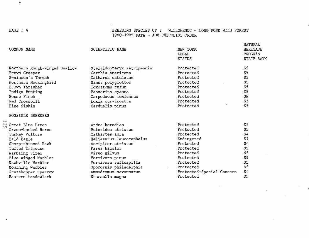
1--'
,e
PAGE 4
COMMON NAME
Northern Rough-winged Swallow Brown Creeper Swainson's Thrush Northern Mockingbird Brown Thrasher Indigo Bunting House Finch Red Crossbill Pine Siskin
POSSIBLE BREEDERS
~ Great Blue Heron Green-backed Heron Turkey Vulture Bald Eagle Sharp-shinned Hawk Tufted Titmouse Warbling Vireo Blue-winged Warbler Nashville Warbler Mourning Warbler Grasshopper Sparrow Eastern Meadowlark
BREEDING SPECIES OF : WILLOWEMOC - LONG POND WILD FOREST 1980-198S DATA - AOU CHECKLIST ORDER
SCIENTIFIC NAME
Stelgidopteryx serripennis Certhia americana Catharus ustulatus Mimus polyglottos Toxostoma rufum Passerina cyanea Carpodacus mexicanus Loxia curvirostra Carduelis pinus
Ardea herodias Butorides striatus Cathartes aura Haliaeetus leucocephalus Accipiter striatus Parus bicolor Vireo gilvus Vermivora pinus Vermivora ruficapilla Oporornis philadelphia Ammodramus savannarum Sturnella magna
NATURAL NEW YORK HERITAGE LEGAL PROGRAM STATUS STATE RANK
Protected SS Protected SS Protected SS Protected SS Protected SS Protected SS Protected SE Protected S3 Protected SS
Protected SS Protected SS Protected S4 Endangered Sl Protected S4 Protected SS Protected SS Protected SS Protected SS Protected SS Protected-Special Concern S4 Protected SS

I-'
"' J'I
'"
PAGE : 5
BREEDING SPECIES OF :BIRDS-
WILLOWEMOC - LONG POND F'OREST
ADDITIONAL Poss::::BLE BREEDERS (as listed in "Integrating Timbe:." and Wildlife Mana9ement Handbook", Chambers, 1983; not in Atlas of Breeding Birds)
COMMON NAME
Hooded Merganser Northern Goshawk Cooper's Hawk Peregrine Falcon Cammon Snipe Ba.rn Owl Whip-Poor-Will Cammon Nighthawk Red-Headed Woodpecker Willow Flycatcher Purple Martin Grey-Cheeked Thrush Blue-Gray Gnatcatcher Worm-Eating Warbler Ga·lden-Winged Warbler ce,rulean Warbler Blackpoll Warbler Ye,llow Breasted Chat Hooded Warbler Ve,sper Sparrow
DH = Delaware Hills CP = Catskill Peaks
SCIENTIFIC NAME
Lophodytes cucullatus Accipiter gentilis Accipiter cooperii Falco peregrinus Capella 9allinago Tyto galli:iago Caprimul~us vociferus Chorde:ilcs Minor Melanerpes erythrocephalus Empidonax traillii Progne subis Catharus minimus Polioptila caerulea Helmitheros vermivorus Vermivore>. chrysoptera Dendroica cerulea Dendroica striata Icteria virens Wilsonia citrina Pooecetes gramineus
sus2:0NE
DH DH ~< CP DH & CP CP DH Ee CP DH DH E< CP DH E< CP DH DH E< CP DH !< CP CP Cl? Cl? Cl? Cl? Cl? DH Iii: CP CP DH Iii: CP
NATUJRAL HERI'I'AGE PROGRAM STATE RANK
SC E
SC
SC
SC

Appendix B-4. Status and occurrence of New York mammals in the Willowemoc - Long Pond Wild Forest, a part of the Catskill Peaks and Delaware Hills subzone as listed in "Integrating Timber and Wildlife Management Handbook" (Chambers, 1983).
SPECIES
Virginia Opossum Masked Shrew Smoky Shrew Longtail Shrew water Shrew Plumy Shrew Least Shrew
STATUS*
Shorttail Shrew Starnose Mole Hairy-taled Mole Little Brown Bat Keen's Bat Small-Footed Bat SC Silver-Haired Bat Eastern Pipistrelle Big Brown Bat Red Bat Hoary Bat Black Bear GS Raccoon GS Whitetailed Deer GS Fisher GS River otter GS Striped Skunk GS Red Fox GS Bobcat GS Opossum GS
SPECIES
Eastern Chipmunk Gray Squirrel Red Squirrel Southern Flying Squirrel
Northern Flying Squirrel Beaver Deer Mouse White-Footed Mouse Southern Bog Lemming Southern Red-Backed Vole Meadow Vole Woodland Vole Muskrat Meadow Jumping Mouse Woodland Jumping Mouse Porcupine Snowshoe Hare Eastern Cottontail Mink Shorttail Weasel Longtail Weasel Coyote Gray Fox Woodchuck
*Status = status in New York State, SC = Special Concern GS = Game Species
127
STATUS*
GS
GS
GS
GS GS GS GS GS GS GS GS

Appendix B-5:
SPECIES
Blacknose dace Longnose dace White sucker Common shiner Golden shiner American eel Sculpin Creek chub Cutlips minnow Mad ton Puinpkinseed Chain pickerel Yellow perch Brown bullhead Smallmouth bass Largemouth bass Brown trout Brook trout
Fish Species occurring in the waters of the Willowemoc - Long Pond Wild Forest based upon historical surveys from 1936-1989.
128

LEGEND
"Fall Brook Leanto Long Pond Leanto Balsam Lake Mtn.
"Long Pond Leanto Mongaup Pond
"Round Pond
"Round Pond
"Fall Brook Leanto Quaker Clearing
Balsam Lake Mt.
"Long Pond Leanto West Access & Parking Area Via South Loop Complete Loop
"East Access & Parking Area
"West Access & Parking Area Via North Loop Long Pond Leanto Via North Loop
"Snowmobile Trail"
"Snowmobile Trail"
"East Access & Parking Area"
"West Access & Parking
"Long Pond Leanto
APPENDIX C - SIGN INVENTORY
4.85 mi. 4.05 mi.
11.95 mi. 11
3.75 mi. 7.25 mi."
.3 mi."
.3 mi."
4.55 mi. 8.90 mi. 11. 65 mi."
1. 8 mi.
2.6 mi. 4.1 mi."
2.0 mi."
1. 5 mi.
2.3 mi."
3.8 mi."
.8 mi. 11
• 1 mi• II
129
ARROW* MARKER*
R y
L R
R y
R y
R y
L s
R s
R s
R s
L s
R s
L s
L
LOCATION
Round Pond
Basily/Willowemoc Rd. Jct.
Basily/Willowemoc Rd. Jct.
Easily/ Willowemoc Rd. Jct.
Basily/Willowemoc Rd. Jct.
Easily Road
Easily Road
Easily Road
Various Locations
Various Locations
Long Pond Spur Tr. Jct.
Long Pond Spur Tr. Jct.
Long Pond Spur Tr. Jct.

LEGEND AR...'t{OW*
"Long Pond Trailhead Parking Area"
"Mongaup Pond Snowmobile Trail 3.0 mi. Mongaup Pond - Hardenburg Parking Area via Mongaup Pond 10.5 mi."
"Mongaup Pond Snowmobile Trail 3.0 mi. Mongaup Pond - Hardenburg Parking Area via Mongaup Pond 10.5 mi. 11
"Mongaup Pond Snowmobile Trail 2.5 mi. Long Pond/Beaverkill Mongaup Pond Campsite 3. 5 mi."
"Long Pond Snowmobile Trail Long Pond Leanto
"Hardenburg Road Mongaup Pond
.5 mi. 1.3 mi."
6.1 mi. 5. 8 mi.
"Camping Prohibited within 150 Feet of Road, Trail or Water except at designated locations"
Trail
Information Board
Motor Vehicles Prohibited
State Land Boundary Private land beyond this point
"Upper Mongaup Loop .5 miles"
L
R
R
R
L
R
R
130
MAP.KER*
y
R
R
s
LOCATION
Fluggertown Road
Fluggertown Road
Fluggertown Road
Ridge Trail Jct.w/ Mongaup/
Willowemoc Trail
Ridge Trail Jct. w/Mongaup/ Willowemoc Trail
Ridge Trail Jct. w/Mongaup/ Willowemoc Trail
Various Locations
Beech Mountain Road
Beech Mountain Road
Various Locations
Various Locations
Southern Jct. w/ Mongaup Pond Trail

LEGEND ARROW* MARKER* LOCATION
"Lower Mongaup Loop • 3 miles L s Southern Jct. w/ Mongaup Pond .6 miles Mongaup Pond Campsite Entrance and Trail Parking Area 2.0 miles"
"Mongaup Pond Parking R s Southern Jct. w/ Area and Campsite 4.2 miles" Mongaup Pond
Trail
"Upper Mongaup Loop .5 miles" L s Northern Jct. w/Mongaup Pond Trail
"Lower Mongaup Loop • 3 miles R s Northern Jct. campsite Entrance and w/Mongaup Parking Area 4.5 miles" Pond Trail
"Mongaup Pond • 3 miles L s Northern Jct . Campsite Entrance and w/Mongaup Parking Area 1. 7 miles" Pond Trail
R = Right, L = Left * Arrow: * Marker: R = Red, Y = Yellow, S = Snowmobile Trail Marker (Red)
131

•
•
APPENDIX D - EASEMENTS
Proceeding 5818 llaER 1371 ?A(;E 539 DEPARTMENT OF ENVIRONMENTAL
CONSERVATION ,, E-CFP SULLIVAN 75.6
CONSERVATION AND TRAIL USE EASEMENT (Beech Mountain Nature Preserve)
This Easement, made this SD 11:: day of J1 a..tvct.__ , 198'""2, between Open Space Institute, Inc., a not-for-profit ~i~rZl~ organized and existing under the laws of the State ofe " , with an office at 122 East 42nd Street, New York, New York 10168, Grantor,
and
THE PEOPLE OF THE STATE OF NEW YORK, acting through the Department of Environmental Conservation with its principal office at 50 Wolf Road, Albany, New York 12233-0001, Grantees.
WHEREAS the Grantor is the owner in fee simple of certain real property hereinafter more fully described in Schedule A attached hereto, and hereinafter referred to as the Protected Property; and
WHEREAS, the People of the State of New York have recognized the benefit of providing for the protection, maintenance and perservation of the natural environment and have enacted the Environmental Quality Bond Act of 1986 and have implemented the Environmental Quality Bond Act of 1986 by enacting Article, 5.2 of the Enyironmental Conservation Law; and
WHEREAS, the Legislature of the State of New York has declared the public policy of the State to be conservation, preservation and protection of its environmental assets and natural and man-made resources, and in furtherance thereof, has enacted Article 49, Title 3, of the Environmental Conservation Law, hereinafter called "the
----=--conserv-ation Law"-, -to prov-ide for and encourage the limitation and restriction of development1 management-and use of real property through conservation easements7-and - -
WHEREAS, the Grantees hold fee title to certain real property (hereinafter more fully described in Schedule B, annexed hereto and
made a part hereof and referred to as the "Benefited Property"), which Benefited Property adjoins the Protected Property and which was conveyed to the Grantees by the Grantor by deed of even date herewith; and
WHEREAS, the Protected Property.in its present natural, scenic, open space and wooded condition-has s~bstantial and significant natural resource value by reason of the fact that it has not been subject to any extensive development or exploitation, and its value will not be affected by the continued maintenance in their present condition of such structures and facilities as presently exlst; and
WHEREAS, the Protected Property and the Benefited Property are appurtenant to one another so that any change in the present natural, scenic, open space and wooded condition of the Protected Property would have an effect on the natural, scenic, open space and wooded condition of the Benefited Property; and
WHEREAS, the Grantor and the Grantees recognize the value and the special character of the Catskill Park in which both the Protected and Benefited Properties are located and the Grantor and the Grantees have, in common, the purpose and objective of protecting and conserving the inherent, natural, tangible and intangible values of the Protected Property as a natural, aesthetic, scientific and educatlnnal racn~rc~; ~nd
132
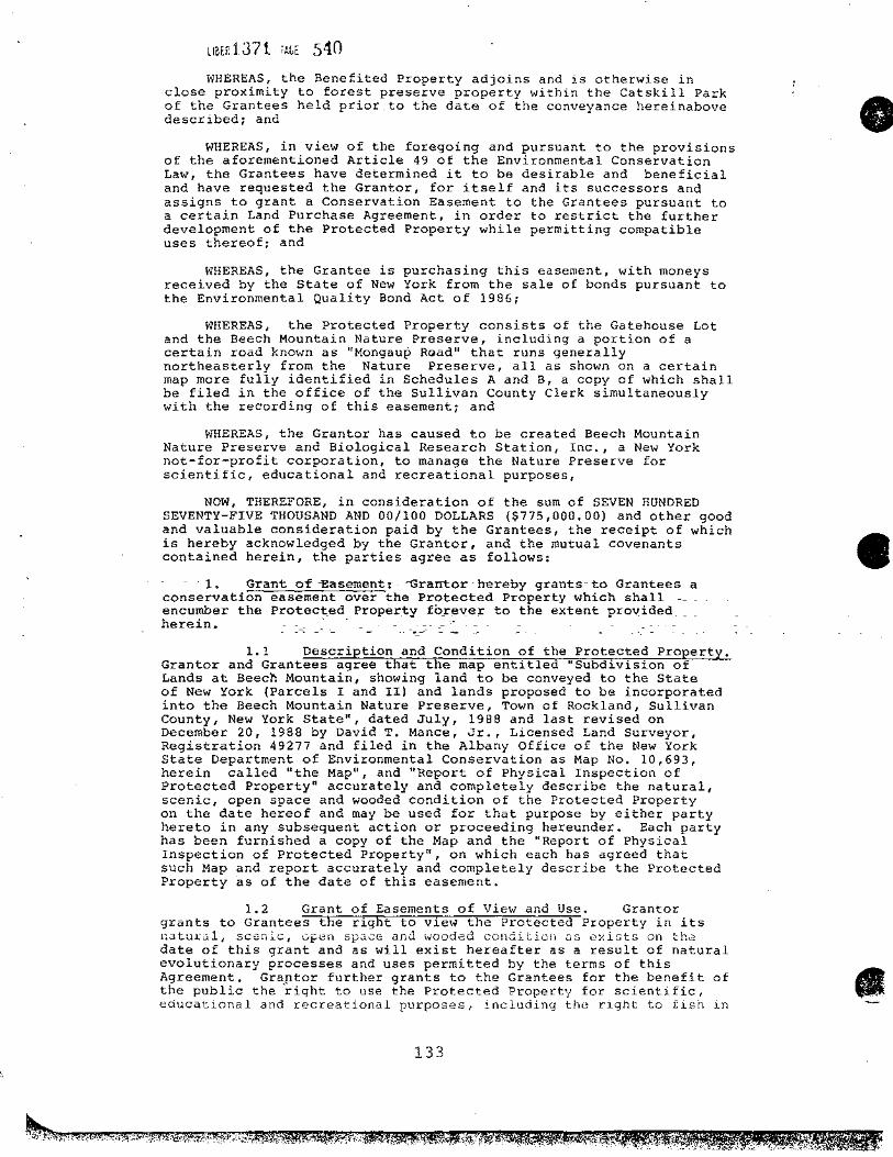
LIBEF: 13 7 i iAGE 5 4 0
WHEREAS, the Benefited Property adjoins and is otherwise in close proximity to forest preserve property within the Catskill Park of the Grantees held prior to the date of the conveyance hereinabove described; and
WHEREAS, in view of the foregoing and pursuant to the provisions of the aforementioned Article 49 of the Environmental Conservation Law, the Grantees have determined it to be desirable and beneficial and have requested the Grantor, for itself and its successors and assigns to grant a Conservation Easement to the Grantees pursuant to a certain Land Purchase Agreement, in order to restrict the further development of the Protected Property while permitting compatible uses thereof; and
WHEREAS, the Grantee is purchasing this easement, with moneys received by the State of New York from the sale of bonds pursuant to the Environmental Quality Bond Act of 1986;
WHEREAS, the Protected Property consists of the Gatehouse Lot and the Beech Mountain Nature Preserve, including a portion of a certain road known as "Mongau~ Road" that runs generally northeasterly from the Nature Preserve, all as shown on a certain map more fully identified in Schedules A and B, a copy of which shall be filed in the office of the Sullivan County Clerk simultaneously with the recording of this easement; and
WHEREAS, the Grantor has caused to be created Beech Mountain Nature Preserve and Biological Research Station, Inc., a New York not-for-profit corporation, to manage the Nature Preserve for scientific, educational and recreational purposes,
NOW, THEREFORE, in consideration of the sum of SEVEN HUNDRED SEVENTY-FIVE THOUSAND AND 00/100 DOLLARS ($775,000.00) and other good and valuable consideration paid by the Grantees, the receipt of which is hereby acknowledged by the Grantor, and the mutual covenants contained herein, the parties agree as follows:
- 1. Grant o-f --Easement-~ - -Grantor-hereby grants- to Grantees a conservation easement over the Protected Property which shall -- _ encumber the Prot13ct,ed Proper_ty fo_reve:r to the extent_ pro\l_ided __ _ herein. - - ------
- ..-~ - - -- -1.1 Description and Condition of the Protected Property.
Grantor and Grantees agree that the map entitled "Subdivision of Lands at Beech Mountain, showing land to be conveyed to the State of New York (Parcels I and II) and lands proposed to be incorporated into the Beech Mountain Nature Preserve, Town of Rockland, Sullivan County, New York State", dated July, 1988 and last revised on December 20, 1988 by David T. Mance, Jr., Licensed Land Surveyor, Registration 49277 and filed in the Albany Office of the New York State Department of Environmental Conservation as Map No. 10,693, herein called "the Map", and "Report of Physical Inspection of Protected Property" accurately and completely describe the natural, scenic, open space and wooded condition of the Protected Property on the date hereof and may be used for that purpose by either party hereto in any subsequent action or proceeding hereunder. Each party has been furnished a copy of the Map and the "Report of Physical Inspection of Protected Property", on which each has agreed that such Map and report accurately and completely describe the Protected Property as of the date of this easement.
1.2 Grant of Easements of View and Use. Granter grants to Grantees the right to view the Protected Property in its natural, scenic, open space and wooded condition as exists on the date of this grant and as will exist hereafter as a result of natural evolutionary processes and uses permitted by the terms of this Agreement. Gr~~tor further grants to the Grantees for the benefit of the public the right to use the Protected Property for scientific, educational and recreational purposes, including the right to fish in
133
•
•

•
•
umt37 t ?AGr 541 Hodge Pond, all subject to the reasonable management and programs of the Beech Mountain Nature Preserve and Biological Research Station, Inc., its successors and assigns .
1.3 Grant of Trail Use Easement. Granter grants to Grantees and the public an easement for travel by foot on the trails on the Protected Property shown on the Map, and on such other trails as shall be determined from time to time hereafter by agreement of the Grantor and the Grantees. The right to use such trails shall be limited to the width of the trails and shall be solely for hiking, skiing, snowshoeing and other travel by foot consistent with the use of the Protected Property as otherwise provided herein. Granter shall have the right from time to time, subject to the approval of the Grantees (which approval will not be unreasonably withheld), to close or otherwise limit access to any trail for such length of time as the Grantor determines may be reasonably necessary for maintenance and repair, and to protect the trails from misuse or overuse, from damage by fire, drought or other disaster or threat thereof, or under any circumstance in which the failure to do so might constitute a threat to the tranquility, public health, safety and welfare or to the natural, aesthetic, scientific, educational or.recreational resources of the Protected Property. The terms hereof shall be strictly construed, and nothing herein shall be deemed a grant to the Grantees or the public of the right to use any portion of the Protected Property other than its designated trails and for those purposes set forth in 1.2 above. '
1.4 Grant of Trail and Road Use Easement for Emergency and Administrative Purposes.
L •"
Granter grants to Grantees an easement for vehicular and foot travel on the trails and roads on the Protected Property for administrative and emergency purposes. Use of such trails and roads for administrative purposes shall be subject to the rights of the Grantor to close or otherwise limit access to any trail or road as set forth in 1.3 hereinabove, and to keep trails and roads unplowed in winter.
2. Restrictions Applicable to the Protected Property.
The following restrictions apply to the Prote9:t~9- _ Prol2_erty_:-.;:_~- -::- _
2.1 Subdivision. divided or subdivided.
The Protected Property shall not be
2.2 Use. The Nature Preserve shall be used only for scientific, educational and recreational activities. No commercial or industrial use shall be permitted.
2.3 Structures. No permanent or temporary structure may be erected or maintained on the Protected Property except for the following:
{a) On the Gatehouso lot, the single-family residential dwelling that presently exists and appropriate accessory structures;
(b)
(i)
On the Nature Preserve,
Tho ro~h; n-+-uno tit..1011; nf"f +-h.::a+- 1"'\rocon.f...1,,. OV'.; e!+.C! ............ ....--4-•• -J, l:'- _, . ._. ___ .... ':1 -··- - l:' ... - .................... :I ..... ..no. ............. ......
near the summit of Beech Mountain, and its presently existing accessory structure;
(ii) Two cabin-type dwellings simil~r to the exis~ing one near the sununit of Beech Mountain with appropriate accessory structures to be constructed on existing cleared sites or at such other locations as the Granter and Grantees <':" 'h '""l 1 1 -. ...... - '"),..., • ~' • •·-~ ... ·'· '' :i - -.... '-I
134
········-----·~·---- p q: '·

usrnl37 i ?ALE 542 (iii) A headquarters building with appropriate
facilities for visitors to the nature preserve, and appropriate accessory structures;
(iv) A single-family residential dwelling and appropriate accessory structure to be used as a residence for a nature preserve employee;
(v)
(vi)
(vii)
A buildi~g for boat storage and a dock;
Tent platforms and lean-to's; and
Such other structures as the Grantor and Grantees shall agree.
(c) Such permanent or temporary structures as are necessary or appropriate for roads and trails, such as bridges, culverts, railings, fences and gates.
(d) A dam on-Hodge Pond, if appropriate under 2.2.
Any structure shall be sited, constructed and landscaped so as to be aesthetically compatible with the surroundings.
Any structure may be maintained, renovated, removed or replaced, provided the resulting structure shall otherwise comply with the terms of this Agreement.
2.4 No Mobile Homes. are prohibited,
Mobile homes and house trailers
2.5 Height and Size Limitations. Each dwelling, including any dwelling that replaces a presently existing dwelling, shall have a maximum floor area of 1,750 square feet and a maximum height of twenty-five (25) feet. The headquarters building shall have a maximum floor area of 10,000 square feet and a maximum height
- of ~hirty-five (35) feet. All other structures shall have a maximum floor are~ of .500 square feet and a maximum height of fifteen (15)
_-feet. -Height shall be measured fro·m ayerage finished grade to peak . -of roof. - . . - - --- -- - - -
2.6 Utilities. The installation of wells, septic systems, electric and bther utility distribution lines shall be permitted in connection with the permitted structures and shall be designed and sited to blend as much as practicable with the environment.
2.7 Grading. Any structure or improvement shall be designed to relate to existing slopes and contours. Any grading shall blend into the natural topography of the parcel and shall be limited to the minimum necessary for roads, trails, driveways, parking areas and foundations.
2.8 Exterior Appearance.
(a)· No billboard of any kind shall be permitted. No illuminated signs shall be permitted. No signs of any kind shall be permitted except those of professional quality and size which either are customarily used for posting, to mark a trail, roadway or structure, or are otherwise appropriate for nature preserve activities.
(b) Any antenna or outdoor fixture slJall Le unobtrusive.
2.9 ,Garbage Disposal. No outdoor storage or disposal of garbage or refuse shall be permitted except for temoorary storaqe in
135
•
•
•

•
-.., __ - __ -= - ... - - -
ll~E~1.17l ~AGE 543
enclosed and screened receptacles. Garbage or refuse may not be dumped or burned and shall be regularly removed •
2.10 Chemicals. No pesticide, herbicide or other chemical treatment for land, vegetation or animals shall be used unless its use is necessary (as shall be jointly determined by the Grantor and the Grantees) , safe for humans and will not contaminate any source of drinking water.
2.11 Nuisance. No visual, aural or olfactory nuisance shall be maintained.
2.12 Hunting and Trapping. No hunting or trapping shall be allowed except to the extent the Granter determines is necessary to prevent disease or to maintain a desirable ecological balance. Any such determination shall be made after consultation with the Department of Environmental Conservation.
2.13 Fishing. No fishing shall be allowed other than in Hodge Pond as provided for hereinabove in 1.2.
2.14 Trails, Roads and Parking Lots. The Granter shall have the right to construct new trails, roads and parking lots. The Granter shall have the right to maintain, repair, abandon or relocate any trail, road or parking lot.
2.15 Off-Road Vehicles. No off-road vehicles, including a snowmobile, motor bike or all-terrain-vehicle shall be used except for maintenance, maple sap collecting, patrol or emergency purposes •
. ~•"' .
2 .16 Timber. No cuttiri-g or removing of trees or other natural landscaping shall be permitted, except: (i) to remove those trees which are fallen, dead, diseased or dangerous; (ii) to provide for the construction of structures or improvements allowed under this Agreement; (iii) to maintain views, trails, roads and existing open spa'ces; and (iv) subject to approval of the Grantees, j::.Q ci:::_eate_ cnew _views_ and open spaces.
2.)7 ~ining. _No quar~y, gravel pit,. surface_ or subsurf?,ce m.i,nin<;Jc or- 4ri:!J,.fog_ sh.all be permi.tte_d, e.xcept from. t.he exlsti-ng quarry -for·-io-ad" and trail maintenance. • - c - - - -
2.18 Livestock. No livestock shall be permitted.
2.19 Streams. No diversion or damming of springs or streams shall be permitted except as may be approved jointly by the Granter and the Grantees or to the extent required by law.
2.20 Hodge Pond. No alteration of Hodge Pond shall be permitted, except that the Granter may take all necessary action to preserve or adjust water levels and the purity of the water, and to prevent or repair damage caused by erosion of its shoreline. No motor boats shall be allowed.
2.21 Laws. All applicable laws and regulations shall be complied with, including, but not limited to, those relating to construction, sewage disposal, mining, hunting, fishing and trapping.
3. Reserved Rights. Granter reserves for itself and its successors in interest with respect to the Protected Property all rights with respect to the Protected Property, including, without limitation, the right of exclusive use, possession and enjoyment of the Prote<;tect ?rc::-~r-1::/ 2r.d ~:!:2 r.:.-:;~·1t to .:;;ell, t.ransier, lease, mortgage or otherwise encumber the Protected Property, all subject to the terms of this Agreement and the maintenance on the Nature Preserve of a biological research station at which environmental education programs are conducted.
136
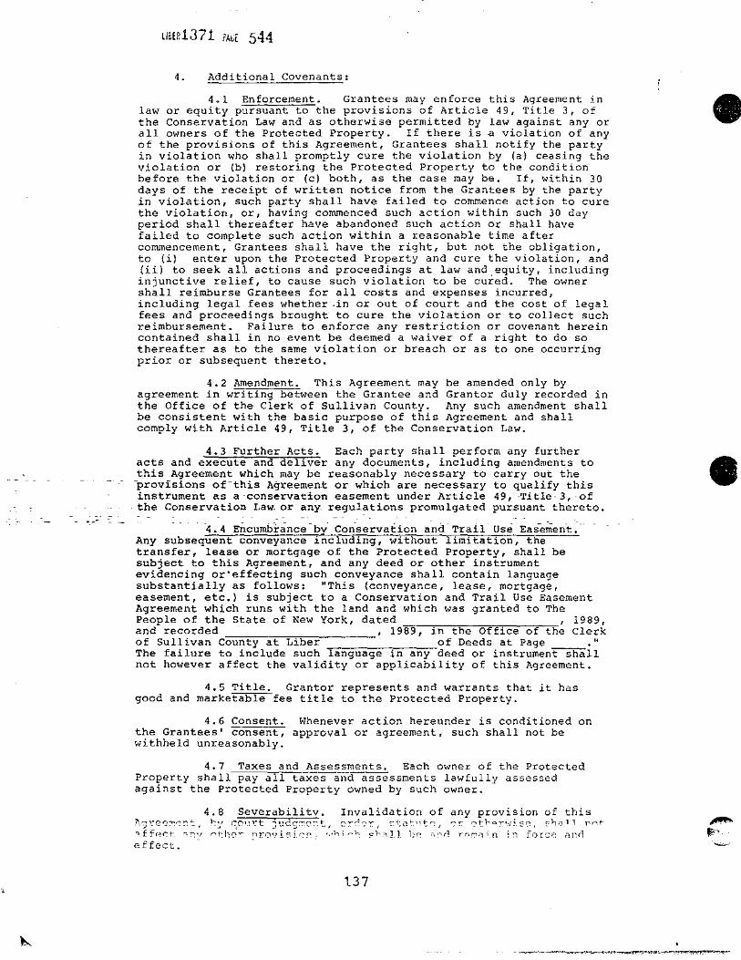
LlaER1J7 i i'AGt 544
4. Additional Covenants:
4.1 Enforcement. Grantees may enforce this Agreement in law or equity pursuant to the provisions of Article 49, Title 3, of the Conservation Law and as otherwise permitted by law against any or all owners of the Protected Property. If there is a violation of any of the provisions of this Agreement, Grantees shall notify the party in violation who shall promptly cure the violation by (a) ceasing the violation or (b) restoring the Protected Property to the condition before the violation or (c) both, as the case may be. If, within 30 days of the receipt of written notice from the Grantees by the party in violation, such party shall have failed to commence action to cure the violation, or, having commenced such action within such 30 day period shall thereafter have abandoned such action or shall have failed to complete such action within a reasonable time after commencement, Grantees shall have the right, but not the obligation, to (i) enter upon the Protected Property and cure the violation, and (ii) to seek all actions and proceedings at law and equity, including injunctive relief, to cause such violation to be cured. The owner shall reimburse Grantees for all costs and expenses incurred, including legal fees whether·~in or out of court and the cost of legal fees and proceedings brought to cure the violation or to collect such reimbursement. Failure to enforce any restriction or covenant herein contained shall in no event be deemed a waiver of a right to do so thereafter as to the same violation or breach or as to one occurring prior or subsequent thereto.
4.2 Amendment. This Agreement may be amended only by agreement in writing between the Grantee and Granter duly recorded in the Office of the Clerk of Sullivan County. Any such amendment shall be consistent with the basic purpose of this Agreement and shall comply with Article 49, Title 3, of the Conservation Law.
4.3 Further Acts. Each party shall perform any further acts and execute and deliver any documents, including amendments to this Agreement which may be reasonably necessary to carry out the -provisions- of-this- Agreement or which are necessary to qualify this instrument as a-conservation easement under Article 49, -Title-3, -of
- the Conservation LaW- or any reguJ.~tions promulgated pursuant ±hereto.
- -4.4 Encumbrance-by Conservation and Trail-Use Ease~ent.--Any subsequent conveyance including, without limitation, the transfer, lease or mortgage of the Protected Property, shall be subject to this Agreement, and any deed or other instrument evidencing or'effecting such conveyance shall contain language substantially as follows: "This (conveyance, lease, mortgage, easement, etc.) is subject to a Conservation and Trail Use Easement Agreement which runs with the land and which was granted to The People of the State of New York, dated , 1989, and recorded , 1989, in the Office of the Clerk of Sullivan County at Liber of Deeds at Page ." The failure to include such language in any deed or instrument shall not however affect the validity or applicability of this Agreement.
4.5 Title. Granter represents and warrants that it has good and marketable fee title to the Protected Property.
4.6 Consent. Whenever action hereunder is conditioned on the Grantees' consent, approval or agreement, such shall not be withheld unreasonably.
4.7 Taxes and Assessments. Each owner of the Protected Property shall pay all taxes and assessments lawfully assessed against the Protected Property owned by such owner.
4.8 Severabilitv. Invalidation of any provision of this .7\g!"e~:-n.~!:":, !::r c:,9,_11::'t judg!:!c~.t, c:c~r::>!:', si:at 1 1t~, c-r 0t1:'?:r:-'.·1i.se, :-hc::i1l rird: ."lffr~r:t-. ,,,,.,, "t:he".' ~rovisicn.,- ,,,h;~i., sh.~Jl be> "''n rc>r;iriin in force 2r.o effect.
137
•
•

•
•-
LIBER137 i ?AGE 54S
4.9 Validity, This Agreement is intended by the Grantor and the Grantees to be a valid legal instrument anq to qualify as a conservation easement under both the common law and the Conservation Law. The failure of this Agreement to qualify as a conservation easement under the Conservation Law shall not affect its validity under the common law. ·
4.10 Binding Effect. This Agreement binds and inures to the benefit of the parties and their respective successors and assigns. The provisions of this Agreement shall run with the land and shall be binding on each owner of and party entitled to possession or use of, the Protected Property for so long as such party is the owner or entitled to possession or use thereof and only with respect to the Protected Property owned by such party or to which such party shall be entitled to possession or use, but nothing herein shall relieve any such party from any liability arising hereunder during the period that such party was the owner or entitled to possession or use of the Protected Property. As used in this Section 4.11, the "owner" shall include the owner of any beneficial or equitable interest in all or a part of the Protected Property.
4.11 Transfer of Title. Granter agrees, within five years from the date hereof, to establish or cause to be established on the Protected Property a biological research stat~on at which will be conducted environmental education programs. If Grantees determine, at any time after five years from the date hereof, that the use of the Protected Property as a biological research station and the conduct thereon of environmental education programs either have not begun or, having beguni~have ended, Grantees shall so notify Granter and the then title holder of record of the Protected Property. Within six months from the receipt of such notification by Granter and the then title holder of the Protected Property, either (a) sufficient evidence shall be provided to establish that Grantees' determination is incorrect as of the date of such notice, or (b) the then_title.holder of_ record_ shall execute and deliver to Grantees a deed conveying fee ti~le to_the_p~otected property to Grantees or their designee for no consideration. Notwithstanding the foregoing,-~v~n ii;, j.nsu_fficient eyidenc~ i~ pro,vi<'.l.ed, the parties may agree on a
- --plan- for the -continued- operation- of the Nature Preserve._
IN WITNESS WHEREOF, the parties have executed this ins-~ment as of the day and year first above written.
6-·fr··, .. ,.,4< ~-~~1"" - ·~~r.(:. ::'·1,,;\
1~~r~i~~!~ ''fi;; r j I~! U,,~·· \t·~.;:', ...
BY:
Its:
BY:
OPEN SPACE INSTITUTE, INC.
THE PEOPLE OF THE STATE OF NEW YORK by Thomas c. Jorling, Commissioner
of Environmental Conservation I I d} I
!JfJ TITLE: 1tive Deputy Commissioner
138
.... _~, .'¥'!'. ' }'"'*'-. ' . -·. ,f :z;:o::.:::;~ •

•
•
llBER.1371 i'A~E 555 (36) NORTH 03° 51' 34" WEST 195,04 feet, thence (37) NORTH 10° 22' 51" EAST 98.66 feet to the point of
beginning. ~
CONTAINING 37.21 more or less acres.
TOGETHER WITH the right of the public to cross and recross lands being retained by the Grantor and known as the Mongaup Road which borders Parcel II on the westerly side and separates said Parcel II from the most northerly section of Parcel I. The public shall have the right to cross and recross the said Mongaup Road parcel for purposes of free and unrestricted travel between the said above described Parcels I and II.
Parcel I and Parcel II and their additional easement areas are shown on a certain map entitled, "Subdivision of Lands at Beech Mountain, showing lands to be conveyed to the State of New York (Parcels I and II) and lands proposed to be incorporated into The Beech Mountain Nature Preserve, Town of Rockland, Sullivan County, New York State" dated July 1988 and last revised on December 20, 1988, by David T. Mance, Jr., Licensed Land Surveyor, Registration No. 49277, and filed in the Albany Office of the New York State Department of Environmental Conservation as Map No. 10,693, a copy of which map is to be filed and/or recorded in the Sullivan County Clerk's Office simultaneously with the filing and/or recording of this Conservation and Trail Use Easement .
-- ----
A TRUE RECORD ENTERED '11 b I iq_. ... , ~0~~· JOE PURCELL. CLERK
139

APPENDIX H
NEW YORK STATE DEPARTMENT OF ENVIRONMENTAL CONSERVATION
Town of Rockland Anthony Lenkiewicz
ADDRESSES AND PHONE NUMBERS
REGION 3 OFFICE:
N.Y.S. D.E.C. 21 South Putt Corners Road
New Paltz, NY 12561 (914} 255-5453
FOREST RANGERS:
Town of Hardenburgh Robert Marrone
RD 2 Old Route 17 Livingston Manor, NY 12758 (914} 439-5242
Star Route Lew Beach, NY 12753 (914} 439-4141
Town of Neversink Herbert Lepke Mutton Hill Road Neversink, NY 12765 (914) 985-7744
Town of Denning Robert Zurek P. o. Box 124 Claryville, NY 12725 (914) 985-2215

c
z
0
I I
EXISTING FACILITIES
__..,_ Foot Trail - Snowmobile Trail
--*-- Horse Trail
Private Roads or 1c1 Rights-of-Woy
(See P.36 of UMP)
[I Parking Lot
m Trail Register
II Leonto
a Designated Campsites
mPit Privy
(3 Gravestone
Doom msuilding
Remains
@Dump
% Gate
% Barricade
Utility Line
Fisherman Parking Fishing Rights
B
__ E_ Fishing Access Easement
E
WILLOWEMOC LONG POND WILD FOREST
' ) /
/ /
/ / /
<.
" / '
""""'' " FACILITIES PROPOSALS
._ >E II Abandon foot/Snowmobile Trail
* >E .a. Abandon Horse/Maintain Foot Trail
Primitive Use Trail ~---€>-- Designate OS
-fHi---®-- Designate OS Multiple Use Trail
-18>·-·®- •Construct Multiple Use Trail -*·--{1,-- Designate OS Horse/Bicycle Trail
-*-·-·-&- Construct Horse/Bicycle Trail -'<f·--'ij'-· Construct Foot Access
-G-·-·-t>- Construct Snowmobile Trail ~ 6 New Gale / New Barricade
~ New
lI!l t:-Jew
~ New
~ New
E
i i
·, / v
v E
Parking Lot (ID Trail Register ~ Sign Boord :m: Leonto @
R s
New Pit Privy DJ New Designated a Campsite Remove Building Remains
llDJ Consolidate Dump
FACILITIES
/'' I
' l 7 I / I
I I
l.. I
(
)
Rehabilitate Parking Lot
Rehabilitate Dom
True North Magnetic North \ ~ 11'30'~
~eplace 0 Pit Privy
MILES

" '
I I
{_
c 0
'· '·
'
I I
'
'·
Wetland
Deer Wintering Area
/
·'
B E
WILLOWEMOC
R
LONG POND WILD FOREST
'·
/
' R D' .......
'· l
/ ,. /
/
'·
,.
/
E
'· '·
,.._
.,
/
( '·
·,. '·
v
'·
E N
E v
I I
i
E
N
R s
WETLANDS
N
/·....._ / / . /
...... ...../ .......
'-.;
WILDLIFE
I I '·.J
<..
/
/
I I
I
'·
I
,.J
'-----'----OL_ _____ M_a_,gnetic1 ~,aj r
MILES )' ~
North