wimmera southern mallee - yarriambiack.vic.gov.au · this document has been endorsed by all wimmera...
TRANSCRIPT

WIMMERA SOUTHERN MALLEE
REGIONAL TRANSPORT STRATEGY
OCTOBER 2014

This document has been endorsed by all Wimmera Southern Mallee Councils in August/September
2014
This report: has been prepared by GHD for Wimmera Southern Mallee Regional Councils and may only be used and relied on by Wimmera Southern Mallee Regional Councils for the purpose agreed between GHD and the Wimmera Southern Mallee Regional Councils as set out in section 1 of this report.
GHD otherwise disclaims responsibility to any person other than Wimmera Southern Mallee Regional Councils arising in connection with this report. GHD also excludes implied warranties and conditions, to the extent legally permissible.
The services undertaken by GHD in connection with preparing this report were limited to those specifically detailed in the report and are subject to the scope limitations set out in the report.
The opinions, conclusions and any recommendations in this report are based on conditions encountered and information reviewed at the date of preparation of the report. GHD has no responsibility or obligation to update this report to account for events or changes occurring subsequent to the date that the report was prepared.
The opinions, conclusions and any recommendations in this report are based on assumptions made by GHD described in this report. GHD disclaims liability arising from any of the assumptions being incorrect.
GHD has prepared this report on the basis of information provided by Wimmera Southern Mallee Regional Councils and others who provided information to GHD (including Government authorities)], which GHD has not independently verified or checked beyond the agreed scope of work. GHD does not accept liability in connection with such unverified information, including errors and omissions in the report which were caused by errors or omissions in that information.
Document Status
Rev No.
Author Reviewer Approved for Issue Name Signature Name Signature Date
0 N.Guy L.McGregor L.McGregor 7.7.14
1 N.Guy P.Templer P.Templer 30.7.14
2 N.Guy P.Templer P.Templer 1.8.14
3 N.Guy P.Templer P.Templer 7.8.14
4 N.Guy P.Templer *Signed on original
P.Templer *Signed on original
13.8.14
i | P a g e
Executive summary The Wimmera Southern Mallee Regional Transport Strategy is an evidence-based strategy which:
Identifies priority transport projects of regional significance.
Ensures the Wimmera Southern Mallee’s transport directions are aligned with state, regional and local policy.
The strategy is owned by the Wimmera Southern Mallee councils, comprising of Buloke, Hindmarsh,
Horsham, Northern Grampians, West Wimmera and Yarriambiack. It has been prepared with assistance and input from State Government Authorities.
The Wimmera Southern Mallee Region is a very productive region of the State, especially when
considering its relatively small population base. However, despite its productivity, there are a number of issues which face the region, particularly in relation to the funding opportunities and maintenance of the transport network. Key issues for the region that have been identified, include the following:
Maintenance of the road network. This is particularly focused on the need for significant maintenance on the ‘C’ Class road network. Maintenance of the road network is important for resilience of the network and to accommodate diversion routes if a closure occurs on a key
arterial road.
The increasing number of large vehicles on local roads accessing farms with on-site storage and the changes in the supply chain due to industry and customer requirements.
Public transport accessibility. The Wimmera Southern Mallee Region has a lack of public transport. There are no passenger rail connections and bus services for many of the towns are infrequent and operate at times that are not always user friendly.
Mode split for freight on rail. The volume of freight produced within the region is growing and is expected to continue to grow, particularly in the grain and mineral sands industries. Thus there is a need to improve rail freight to minimise the number of trucks on the roads for maintenance,
safety and amenity.
Tourism. This is a key growth industry of the region, with a focus on outdoor tourism. Therefore active transport connections are critical to allow for this growth. Additionally, road connections to
the key destinations are required to be maintained and improved to allow for tourists to easily access these areas.
Access to services and employment, given much of the region comprises small towns spread
over a large land area.
ii | P a g e
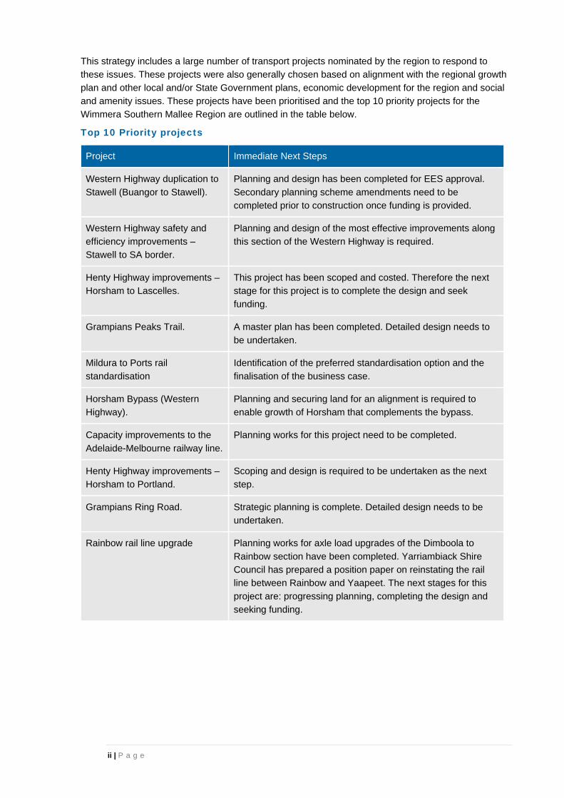
This strategy includes a large number of transport projects nominated by the region to respond to these issues. These projects were also generally chosen based on alignment with the regional growth
plan and other local and/or State Government plans, economic development for the region and social and amenity issues. These projects have been prioritised and the top 10 priority projects for the Wimmera Southern Mallee Region are outlined in the table below.
Top 10 Priority projects
Project Immediate Next Steps
Western Highway duplication to
Stawell (Buangor to Stawell).
Planning and design has been completed for EES approval.
Secondary planning scheme amendments need to be
completed prior to construction once funding is provided.
Western Highway safety and
efficiency improvements –
Stawell to SA border.
Planning and design of the most effective improvements along
this section of the Western Highway is required.
Henty Highway improvements –
Horsham to Lascelles.
This project has been scoped and costed. Therefore the next
stage for this project is to complete the design and seek
funding.
Grampians Peaks Trail. A master plan has been completed. Detailed design needs to
be undertaken.
Mildura to Ports rail
standardisation
Identification of the preferred standardisation option and the
finalisation of the business case.
Horsham Bypass (Western
Highway).
Planning and securing land for an alignment is required to
enable growth of Horsham that complements the bypass.
Capacity improvements to the
Adelaide-Melbourne railway line.
Planning works for this project need to be completed.
Henty Highway improvements –
Horsham to Portland.
Scoping and design is required to be undertaken as the next
step.
Grampians Ring Road. Strategic planning is complete. Detailed design needs to be
undertaken.
Rainbow rail line upgrade Planning works for axle load upgrades of the Dimboola to
Rainbow section have been completed. Yarriambiack Shire
Council has prepared a position paper on reinstating the rail
line between Rainbow and Yaapeet. The next stages for this
project are: progressing planning, completing the design and
seeking funding.

iii | P a g e
Table of contents 1. Introduction .................................................................................................................................... 1
1.1 Project partners .................................................................................................................... 1
1.2 Connections ......................................................................................................................... 1
1.3 Review of strategy ............................................................................................................... 1
2. Project background ........................................................................................................................ 2
3. About the Wimmera Southern Mallee ............................................................................................ 3
4. Strategic view ................................................................................................................................. 5
4.1 Strategic vision ..................................................................................................................... 5
4.2 Strategic objectives .............................................................................................................. 5
4.3 Wimmera Southern Mallee’s challenges ............................................................................. 6
5. Project identification and prioritisation ........................................................................................... 7
5.1 Overall top 10 projects ......................................................................................................... 7
5.2 Top 5 rail projects .............................................................................................................. 10
5.3 Top 5 road projects ............................................................................................................ 10
5.4 Top 5 active transport projects .......................................................................................... 10
5.5 Top 5 airport projects ......................................................................................................... 10
5.6 ‘C’ Class Roads ................................................................................................................. 10
5.7 Planning projects ............................................................................................................... 11
5.8 On-going programs ............................................................................................................ 12
5.9 Other existing strategies .................................................................................................... 12
6. The WSM region’s priority projects .............................................................................................. 13
7. Wimmera Southern Mallee regional issues and projects ............................................................. 24
7.1 Products to market ............................................................................................................. 24
7.2 Maintenance of ‘C’ class roads .......................................................................................... 24
7.3 Access to services ............................................................................................................. 25
7.4 Network Resilience ............................................................................................................ 26
7.5 Rail crossing removal and upgrade program ..................................................................... 26
7.6 Road Making Materials ...................................................................................................... 26
7.7 Tourism .............................................................................................................................. 26
7.8 Sustainability of the airport network ................................................................................... 26
7.9 Alignment with the Murray Basin rail project (Mildura to ports rail standardisation) ................................................................................................................. 27
7.10 Emerging industries ........................................................................................................... 28

iv | P a g e
Table index Table 1: Regional snapshot ...................................................................................................................... 3
Table 2: Top 10 priority projects ............................................................................................................... 8
Table 3: ‘C’ Class Priority Roads............................................................................................................ 11
Figure index
Figure 1: Existing Transport Infrastructure for the Wimmera Southern Mallee Region ........................... 4
Figure 2: Wimmera Southern Mallee Regional Priority Projects .............................................................. 9
Appendices Appendix A – Project list
Appendix B – Achievement of strategic objectives key challenges.
Appendix C – Airport details
1 | P a g e
1. Introduction
The Wimmera Southern Mallee Regional Transport Strategy (herein referred to as ‘the strategy’) is an
evidence-based strategy which:
Identifies priority transport projects of regional significance.
Ensures the Wimmera Southern Mallee’s transport directions are aligned with state, regional
and local policy.
It provides a tool for:
Implementation of the transport frameworks established by the Wimmera Southern Mallee’s
Regional Strategic Plan and Regional Growth Plan.
Future project planning and policy development.
Advocacy to state and federal governments.
Developing and prioritising funding applications.
The strategy is a concise, high level document that should be read in conjunction with the Wimmera Southern Mallee Regional Transport Strategy – Background Report. The background report provides
the context to the region in terms of demographics and economic drivers, the context of the region within current state and federal policies and key issues and opportunities for the region.
1.1 Project partners
The strategy is owned by the Wimmera Southern Mallee councils, comprising the municipalities of Buloke, Hindmarsh, Horsham, Northern Grampians, West Wimmera and Yarriambiack. It has been prepared with assistance and input from the Department of Transport, Planning and Local
Infrastructure (DTPLI), VicRoads and Public Transport Victoria (PTV).
GHD has been engaged to prepare the strategy documentation on behalf of the Wimmera Southern Mallee councils. GHD’s engagement involved consultation with all members of the technical working
group to determine the projects to be included within the prioritisation process. The strategy has been developed in collaboration with the Wimmera Southern Mallee councils and DTPLI and has relied on the background information included in the Wimmera Southern Mallee Transport Strategy –
Background Report.
1.2 Connections
The Wimmera Southern Mallee transport network does not operate in isolation of the wider state
network. The strategy is part of the wider Grampians region and has direct connections to the neighbouring Central Highlands, Barwon South West, Loddon Mallee North and broader Victorian, New South Wales and South Australian transport networks. Whilst the region itself generates a
significant transport task, these movements and supply chains usually extend to areas outside the direct area covered by the strategy. As such the strategy also needs to consider the impact that freight and passenger movements have on the broader network, particularly journeys to major settlements
and international gateways (such as ports) in other parts of the state and country.
1.3 Review of strategy
The Wimmera Southern Mallee Regional Transport Strategy will be reviewed regularly by the Project Steering Committee to ensure that the strategy reflects the goals and conditions of the communities of
the region. Reviews will also take account of policy shifts, completed priorities, introduction of threats or challenges to the strategy, new opportunities for the region and identification of new projects.

2 | P a g e
2. Project background
The Wimmera Southern Mallee region has a strong tradition of regional transport planning. Councils and other key stakeholders form the Wimmera Regional Transport Group which provides a focus for
leadership and strategic planning in relation to the region’s transport needs. Over the last 10 years this group has commissioned a number of plans and studies including the Wimmera Regional Transport Plan (2005, updated 2008), a regional freight transport issues paper (2012) and improvement
strategies for bridges and C Class roads. These strategies have identified key strategic issues and trends affecting the region’s transport network and some potential infrastructure enhancements.
The emphasis on integrated regional planning and community and economic development has
increased in recent years through the development of the Wimmera Southern Mallee’s Regional Strategic Plan (2010).
However since the development of these strategies, there has been a significant evolution in the state
and regional transport and land use policy context with the development of:
Victoria – The Freight State 2013: the Victorian Freight and Logistics Plan.
Regional growth plans.
Plan Melbourne: the Melbourne metropolitan planning strategy.
Victoria’s Road Safety Strategy 2013 – 2022.
Cycling into the Future 2013-23: Victoria’s cycling strategy.
Victoria’s trails strategy 2014-2024.
This strategy builds on the detailed planning and strategy work undertaken by the Wimmera Regional Transport Group over the past decade. It revisits the previously identified issues and proposals for
upgrades to account for this new policy context and ensure detailed planning for transport fully aligns with state and regional imperatives.

3 | P a g e
3. About the Wimmera Southern Mallee
The Wimmera Southern Mallee Region is located on the western side of Victoria, adjoining South Australia. The region has a strong agricultural base and a population of around 55,000 dispersed over
a large area. The area included within this strategy comprises the municipalities of Buloke, Hindmarsh, Horsham, Northern Grampians, West Wimmera and Yarriambiack.
Horsham is the region’s largest town and one of Victoria’s ten designated regional cities. Whilst this is
the major centre of population and services, there are a number of important district towns which service their surrounding communities and smaller centres including Nhill, Stawell, Warracknabeal, St Arnaud, Edenhope, Kaniva, Hopetoun, Dimboola, Charlton, Birchip and Donald.
Agriculture is the dominant land use, economic driver and employment sector in the region, predominantly comprising broad-acre cropping of cereals, pulses and oilseeds in the central and northern parts of the region and livestock grazing in the southern parts. Other key employment sectors
are healthcare, retail, manufacturing, transport and construction.
The Wimmera Southern Mallee is home to a number of important cultural and environmental assets which are critical to the region’s identity, heritage and sustainability. This includes the Grampians,
Little Desert and Wyperfeld National Parks and major lake and river systems. These assets also support the economic development through tourism.
The main road transport corridor in the region is the Western Highway, which connects Horsham,
Stawell and Nhill with Melbourne (via Ballarat), Adelaide and Perth. The Melbourne–Adelaide railway also generally follows the Western Highway alignment and continues to Perth.
There are other important road corridors including the Henty Highway, which runs north–south through
the region and provides access to the Port of Portland. A number of rail lines provide freight services, particularly for the export of bulk commodities such as grain and mineral sands. Other key transport links in the region comprise the Sunraysia Highway, Calder Highway and Geelong to Mildura railway,
which all provide access between the south of the state and Mildura.
Aviation transport is also important within the region. There are a number of airports that serve a variety of purposes from emergency services to servicing agricultural requirements.
Figure 1 presents the existing transport infrastructure in the Wimmera Southern Mallee Region. This highlights the road and rail links through the region and the locations of the primary airports and passenger railway stations.
Table 1: Regional snapshot
Largest towns (2011) Horsham: 15,129 Stawell: 5,655 Warracknabeal: 2,302 St Arnaud: 2,146
Nhill: 1,849 Dimboola: 1,367 Donald: 1,310 Charlton: 943
Projected LGA population
change 2011-2031
Horsham 3,257 (16.7%) Northern Grampians: 122
(1.0%) Yarriambiack: -238 (-3.3%)
Buloke: -424 (-6.6%) Hindmarsh: -421 (-7.2%) West Wimmera: -376 (-8.8%)
Largest economic sectors (Gross Value Added, 2012)
1. Agriculture, fishing and forestry 2. Mining 3. Health care and social
assistance
4. Transport, postal and warehousing
5. Retail 6. Education and training
Largest commodities for Grampians region1
1. Grain 2. Forestry (logs) 3. Meat
4. Mineral sands 5. Livestock 6. Horticulture
1 Includes Central Highlands councils; does not include Buloke

4 | P a g e
Figure 1: Existing Transport Infrastructure for the Wimmera Southern Mallee Region
Source: VicRoads and DTPLI
For further information regarding the background context of the Wimmera Southern Mallee Region refer to the Wimmera Southern Mallee Transport Strategy – Background Report.
5 | P a g e
4. Strategic view
The Wimmera Southern Mallee Region has a number of strategies related to growth of the region and infrastructure required to support this future development that have been developed and updated over
the last 10 years.
An objective of this transport strategy project is to revisit the region’s transport plans and update the strategic context to ensure the Wimmera Southern Mallee’s transport strategies and projects remain
relevant and aligned to government policy. The findings of this process are presented in the Wimmera Southern Mallee Transport Strategy – Background Report.
To assist alignment between this strategy and other key strategies within the region, the technical
working group and project steering committee agreed to adopt the strategic vision and objectives outlined in the Wimmera Southern Mallee Regional Growth Plan, that are related to the transport future directions.
4.1 Strategic vision
The vision for the Wimmera Southern Mallee Region in 2041 presented in the Wimmera Southern Mallee Regional Growth Plan (May 2014) is as follows:
The Wimmera Southern Mallee is a prosperous region which uses its natural advantages of a healthy environment, extensive spaces and a range of urban and rural lifestyle opportunities to attract more residents, businesses and visitors.
Increased primary production remains an important focus of the region, but a more diverse and innovative economy, including new agricultural commodities, industry, tourism, research and education means the community can adapt to changing economic and environmental conditions.
The environment is protected and enhanced by sustainable communities and industry.
People can choose from a variety of places to live throughout the region to suit different lifestyles, with a network of small and large towns providing hubs to access community activity and
services.
Good transport connections are provided within and beyond the region to facilities and markets to improve the competitive advantage of living and working in the Wimmera Southern Mallee.
The final paragraph of this vision is the critical element relevant for the regional transport strategy and therefore has been the key focus for the vision of this strategy.
4.2 Strategic objectives
The Wimmera Southern Mallee Regional Growth Plan outlines a number of future transport directions which have been adopted as the strategic objectives for this transport strategy. These directions are as follows:
– Develop freight and logistics precincts as places to collect and distribute goods.
– Understand and ensure efficient ways to transport products between producers and markets.
– Improve the capacity, safety and functioning of the transport network.
– Ensure access and connectivity.
– Provide for a safe, reliable and resilient network.
– Consider technological advancements in the transport provision mix.
– Ensure amenity and useability.

6 | P a g e
4.3 Wimmera Southern Mallee’s challenges
The Wimmera Southern Mallee Region is a very productive region of the State especially compared to
the population within the region. However, despite the productivity of the region, there are a number of issues which face the region, particularly in relation to the funding opportunities and maintenance of the transport network.
Key issues for the region that have been identified include the following:
Maintenance of the road network.
Maintenance and the funding allocated to for the road network is a critical issue for the Wimmera
Southern Mallee Region and is related to all road classifications, including highways, ‘C’ class roads and local roads. The region has a significant number of kilometres of road to maintain which are utilised by considerable volumes of freight transporting grain, mineral sands and other products.
The current funding provided for maintenance of arterial roads is insufficient and is leading to significant problems, including speed limits on highways in some places, and deterioration of surfaces and shoulders in many areas of the network.
The increasing number of large vehicles on local roads accessing farms due to onsite storage.
The deregulation of the grain industry has increased the number of farms storing products on site. This results in transportation of products occurring throughout the year to meet demand rather than during
a couple of months of the year to store the products in a central silo. Therefore requiring heavy vehicles to travel along the local roads during wet conditions.
A key consequence of this change in the industry supply chain is the deterioration of the local roads to
access the farms and consequently the increased maintenance requirements.
Public transport accessibility.
There are no passenger rail connections within the region and bus services for many of the towns are
infrequent and operate at times that are not always user friendly. This makes connections to facilities that are only offered in regional centres difficult to access.
Mode split for freight on rail.
Road is the predominate mode to transport freight within the region due to supply chain flexibilities and efficiencies associated with road versus rail. As the volume of freight being transported increases, the number of trucks on the road network increases and consequently impact on the maintenance and
quality of the roads and safety and amenity issues for local residents.
Tourism.
Tourism growth within the region is a key opportunity for economic growth however the challenge is
associated with providing the transport network connectivity to encourage this growth. Tourism within the region is primarily associated with walking, cycling and other outdoor activities. The Grampians National Park attracts a large number of tourists undertaking outdoor activities. However, there are
limited walking and cycling trails for tourists and residents in other parts of the region. Additionally, the connectivity of walking and cycling paths between towns is limited.
Small population towns spread over large land area.
The Wimmera Southern Mallee only has the one large township of Horsham with the other townships spread across the region being considerably smaller. This results in key services either being located in numerous locations for small populations or less services (medical facilities, public transport
services) being able to be provided and hence residents are required to travel substantial distances to access these services.

7 | P a g e
5. Project identification and prioritisation
This strategy has identified projects to help implement its strategic vision and objectives. The project identification and prioritisation process has followed a process endorsed by the project steering
committee. The process involved significant input from the technical working group.
The projects were nominated by the technical working group and were generally chosen based on a number of key elements which include:
Alignment with the regional growth plan and other local and/or State Government plans.
The ability for the project to address key issues within the region.
Economic development for the region.
Social and amenity improvements for the region.
A significant number of projects were nominated and then prioritised. The project selection and prioritisation process generally followed the key steps:
The definition of the criteria, scoring and the weighting adopted for the project prioritisation process for the Wimmera Southern Mallee Regional Transport Strategy is provided in the Background Report.
All nominated projects for this strategy are outlined within Appendix A, while the comparison of how
the projects meet the strategic objectives and key regional challenges is included in Appendix B. It should be noted that whilst this list includes a range of projects, the list is not exhaustive of all projects for the region. Rather the projects included within this process are the key projects that are currently
viewed to have significant benefits for the region and address the key regional issues.
5.1 Overall top 10 projects The top 10 priority projects for the Wimmera Southern Mallee Region and the immediate next steps required to progress these projects are outlined in Table 2 and presented in Figure 2.
Project nomination by all members of the Wimmera Southern Mallee Technical Working Group.
Scoring of each project against the set criteria (agreed and endorsed by the Wimmera Southern Mallee Technical Working Group).
Apply weighting for each criterion.
Review of scoring to ensure consistency between project scoring.
Identification of the project rank based on ranking overall scoring formula.
Workshop with Wimmera Southern Mallee Technical Working Group to review the outcomes and identify if particular project have been missed or ranked incorrectly.
Update project prioritisation based on workshop feedback and additional projects to be included.

8 | P a g e
Table 2: Top 10 priority projects
Project Immediate Next Steps
Western Highway duplication to Stawell
(Buangor to Stawell).
Planning and design has been completed for EES
approval. Secondary planning scheme amendments
need to be completed prior to construction once
funding is provided.
Western Highway safety and efficiency
improvements – Stawell to SA border.
Planning and design of the most effective
improvements along this section of the Western
Highway is required.
Henty Highway improvements –
Horsham to Lascelles.
This project has been scoped and costed. Therefore
the next stage for this project is to complete the
design and seek funding.
Grampians Peaks Trail. A master plan has been completed. Detailed design
needs to be undertaken.
Mildura to Ports rail standardisation Identification of the preferred standardisation option
and the finalisation of the business case.
Horsham Bypass (Western Highway). Planning and securing land for an alignment is
required to enable growth of Horsham that
complements the bypass.
Capacity improvements to the Adelaide-
Melbourne railway line.
Planning works for this project need to be completed.
Henty Highway improvements –
Horsham to Portland.
Scoping and design is required to be undertaken as
the next step.
Grampians Ring Road. Strategic planning is complete. Detailed design
needs to be undertaken.
Rainbow rail line upgrade Planning works for axle load upgrades of the
Dimboola to Rainbow section have been completed.
Yarriambiack Shire Council has prepared a position
paper on reinstating the rail line between Rainbow
and Yaapeet. The next stages for this project are:
progressing planning, completing the design and
seeking funding.
For the full list of the projects and scoring, please refer to Appendix A. Refer to Section 6 for a one page summary of the top priority projects.

9 | P a g e
Figure 2: Wimmera Southern Mallee Regional Priority Projects

10 | P a g e
5.2 Top 5 rail projects
The top 5 rail projects identified through the project prioritisation process are:
Mildura to Ports rail standardisation.
Capacity improvements to the Adelaide-Melbourne railway line.
Dimboola to Rainbow rail line axle load upgrade.
Rainbow – Yaapeet rail line upgrade.
Passenger rail extension (shuttle rail service between Kaniva, Horsham and Ararat).
5.3 Top 5 road projects
The top 5 road projects identified through the project prioritisation process are:
Western Highway duplication to Stawell (Buangor to Stawell).
Western Highway safety and efficiency improvements – Stawell to SA border.
Henty Highway improvements – Horsham to Lascelles.
Horsham Bypass (Western Highway).
Henty Highway improvements – Horsham to Portland.
5.4 Top 5 active transport projects
The top 5 active transport projects identified through the project prioritisation process are:
Grampians Peaks Trail.
Stawell to Halls Gap walking/cycling route.
Western Victorian Iconic Walking Trail (Horsham, Hindmarsh and West Wimmera).
Hindmarsh Walking Trail Project.
Nature tracks – pedestrian and cycling facilities within Buloke.
5.5 Top 5 airport projects
The top 5 air projects identified through the project prioritisation process are:
Sea Lake Airport upgrade.
Stawell Airport upgrade.
Hopetoun Airport upgrade.
Rainbow Airstrip upgrade.
Warracknabeal Airport upgrade.
It is noted that a number of the airport upgrade projects were prioritised very close together, for the other airport projects refer to Appendix A. Further details on the airport upgrade projects are included
within Appendix C.
5.6 ‘C’ Class Roads
‘C’ Class roads are critical to the road network and maintenance funding for these roads is important.
There are a significant number of ‘C’ Class roads within the regions that have been identified to require upgrades and maintenance, however it is acknowledged that all of these upgrades cannot be
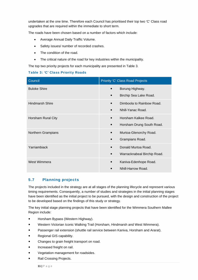
11 | P a g e
undertaken at the one time. Therefore each Council has prioritised their top two ‘C’ Class road upgrades that are required within the immediate to short term.
The roads have been chosen based on a number of factors which include:
Average Annual Daily Traffic Volume.
Safety issues/ number of recorded crashes.
The condition of the road.
The critical nature of the road for key industries within the municipality.
The top two priority projects for each municipality are presented in Table 3.
Table 3: ‘C’ Class Priority Roads
Council Priority ‘C’ Class Road Projects
Buloke Shire Borung Highway.
Birchip Sea Lake Road.
Hindmarsh Shire Dimboola to Rainbow Road.
Nhill-Yanac Road.
Horsham Rural City Horsham Kalkee Road.
Horsham Drung South Road.
Northern Grampians Murtoa-Glenorchy Road.
Grampians Road.
Yarriambiack Donald Murtoa Road.
Warracknabeal Birchip Road.
West Wimmera Kaniva-Edenhope Road.
Nhill-Harrow Road.
5.7 Planning projects
The projects included in the strategy are at all stages of the planning lifecycle and represent various timing requirements. Consequently, a number of studies and strategies in the initial planning stages have been identified as the initial project to be pursued, with the design and construction of the project
to be developed based on the findings of this study or strategy.
The key initial stage planning projects that have been identified for the Wimmera Southern Mallee Region include:
Horsham Bypass (Western Highway).
Western Victorian Iconic Walking Trail (Horsham, Hindmarsh and West Wimmera).
Passenger rail extension (shuttle rail service between Kaniva, Horsham and Ararat).
Regional GIS capability.
Changes to grain freight transport on road.
Increased freight on rail.
Vegetation management for roadsides.
Rail Crossing Projects.

12 | P a g e
5.8 On-going programs
Through the project identification process a number of existing programs have been identified that are
essential to enable the on-going improvements and maintenance of regional infrastructure. There are a large number of programs that the councils within the Wimmera Southern Mallee Region currently seek funding for and some of these programs have been funded in the latest federal and state
budgets.
The funds provided through the various programs are vital for the maintenance of local roads to ensure the roads are maintained to an appropriate standard. The critical programs identified include
the Federal Roads to Recovery Program and the State Country Roads and Bridges Program.
5.9 Other existing strategies
As previously mentioned the Wimmera Southern Mallee Region has completed a number of transport
infrastructure strategies which have identified key issues in the region and priority projects related to this issue.
The strategies include:
Wimmera Regional Transport Group Bridges Strategy Local Roads (August 2010).
Wimmera Regional Transport Group Grey Spots Strategy (November 2012).
Wimmera Regional Transport Group C Route Strategy (October 2009).
Wimmera Regional Transport Group C Route Detour Strategy (August 2011).
Wimmera Regional Transport Group – Regional Freight Transport (May 2012).
Wimmera Regional Transport Plan, “2008 Review” (October 2008).
These strategies have been utilised when determining a number of the projects to be included within the prioritisation process for this strategy. Many of these projects have relatively local benefits but are important for the functioning of the region’s transport networks. These strategies should remain current
and be viewed alongside this overall transport strategy for the region.

13 | P a g e
6. The WSM region’s priority projects

14 | P a g e
Project: Western Highway duplication from Buangor to Stawell
Project description
Construction of the duplication of the Western
Highway between Buangor and Stawell (west
of Gilchrist Road).
The project is a continuation of the currently
funded duplication sections as far as Buangor.
The duplication includes provision for two
lanes in each direction with a central median
and intersection upgrades to improve road
safety and facilitate the efficient movement of
traffic.
In addition the project includes the town
bypasses for Beaufort and Ararat. It is
acknowledged that these bypasses were not
included within the EES documentation that
has been approved, however to improve
efficiency and safety of the highway planning,
design and construction of these bypasses
should be completed with the duplication of the
highway.
Problem identification
The Western Highway is a key east-west interstate route providing the primary freight route between Melbourne, Adelaide and Perth.
The highway passes through the western area of Victoria (including the Wimmera Southern Mallee Region) which is a key farming region and as such
the highway supports agricultural (including grain production), regional tourism and manufacturing industries. The efficiency of this road corridor
affects the efficiency of regional production and hence the long term viability of regional towns and industries.
The high proportion of heavy vehicles and limited passing opportunities can create road safety issues by other vehicles passing at inappropriate
locations. Furthermore, the increasing volume of traffic along the Western Highway is increasing these risks.
Additionally, travel times for cars may be longer due to slow heavy vehicles that cannot be passed.
Project benefits
The duplication of the Western Highway
between Buangor and Stawell provides the following benefits:
Opens up accessibility to the region.
Economic advantages for the region as the area can access Melbourne, ports and other key destinations quicker and
more efficiently.
Improved road safety, including roadside facilities for fatigue management.
Improved road freight efficiency.
Provides greater continuity of road alignment to the region to fit with the
overall Western Highway duplication.
Improved travel times and costs.
Relevance to other WSM strategies
Victorian Freight and Logistics Plan
Regional Growth Plan
Plan Melbourne
Victoria’s Road Safety Strategy
Cycling into the future
Victoria’s trails strategy
WSM Regional Transport Plan
WSM Regional Strategic Plan
WSM Grey Spots Strategy
WSM Arterial Routes Strategy
Council Plans
Estimated Cost
$500 million

15 | P a g e
Project: Western Highway safety and efficiency improvements – Stawell to SA border
Project description
The specific elements of this project
are not set and further planning is
required to identify the most
appropriate and cost effective
treatments to improve road safety and
vehicle efficiency. These solutions are
aimed to be interim term solutions with
the ultimate aim to duplicate the length
of the Western Highway within
Victoria.
Improved overtaking opportunities
along the Western Highway with
possible improvements such as 2+1 or
2+2 in particular places is a potential
solution to improve safety and
efficiency along this section.
Problem identification
The Western Highway is a key east-west interstate route providing the primary freight route between Melbourne, Adelaide and Perth. The road travels through the region
providing a road connection for major industries and local residents.
In the near-term duplication of the Western Highway is
planned as far as Stawell. While the longer term goal is to duplicate the highway through to the South Australian border, this would be uneconomic in the short term.
A series of measures are proposed to add to safety and improve efficiency in this section of the Western Highway as a prelude to longer-term duplication.
Some significant improvements have recently been completed between Stawell and the SA Border, however further opportunities to improve freight efficiency and road
user safety, including:
Increase the number of passing lanes provided.
Improved rest areas.
Installation of more wire rope barriers to minimise the impact of run-off-road collisions.
Project benefits
Providing safety and efficiency
improvements along the Western Highway beyond the proposed duplication sections (between Stawell
and the SA border) provides the following benefits:
Improved road safety.
Improved road freight efficiency.
Improved travel times and costs.
Relevance to other WSM strategies
Victorian Freight and Logistics Plan
Regional Growth Plan
Plan Melbourne
Victoria’s Road Safety Strategy
Cycling into the future
Victoria’s trails strategy
WSM Regional Transport Plan
WSM Regional Strategic Plan
WSM Grey Spots Strategy
WSM Arterial Routes Strategy
Council Plans
Estimated Cost
TBC
16 | P a g e
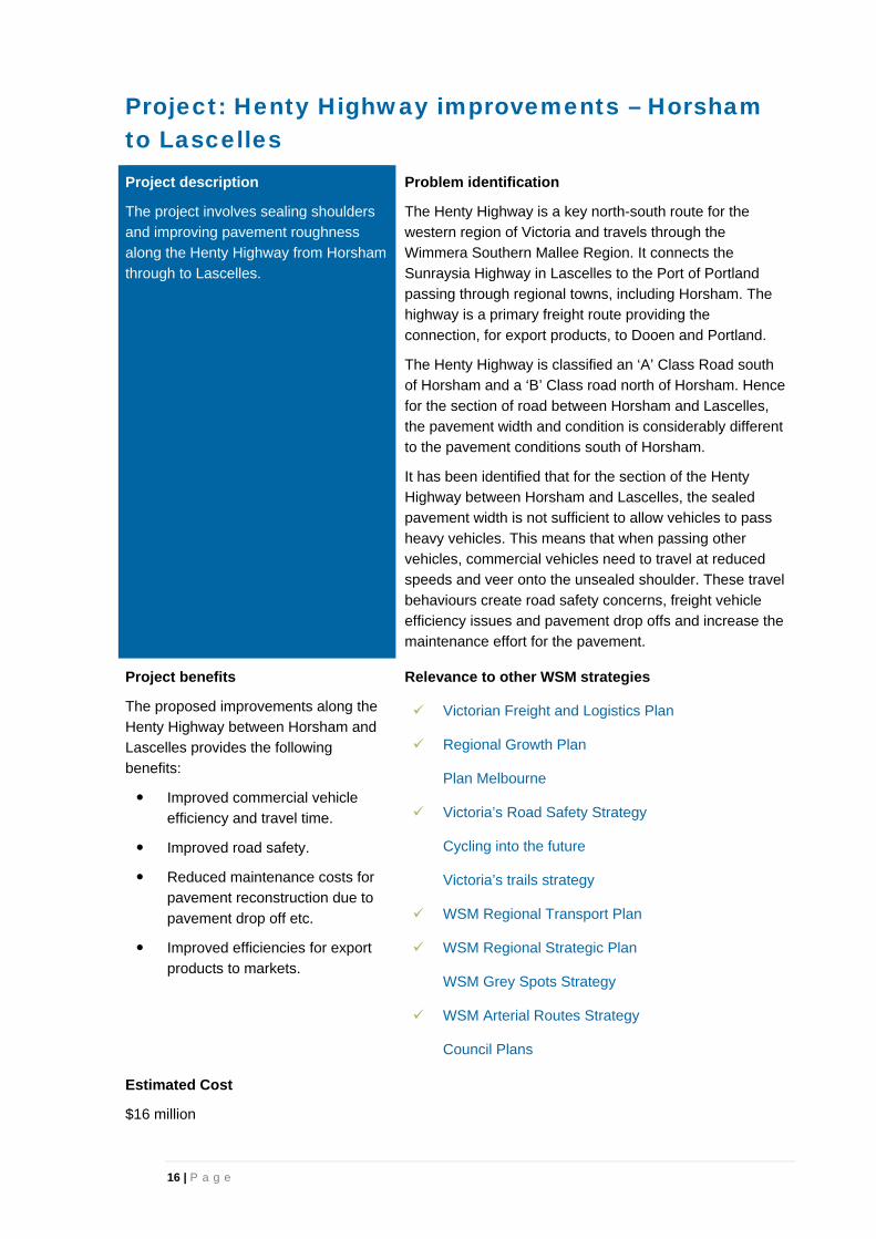
Project: Henty Highway improvements – Horsham to Lascelles
Project description
The project involves sealing shoulders
and improving pavement roughness
along the Henty Highway from Horsham
through to Lascelles.
Problem identification
The Henty Highway is a key north-south route for the western region of Victoria and travels through the Wimmera Southern Mallee Region. It connects the
Sunraysia Highway in Lascelles to the Port of Portland passing through regional towns, including Horsham. The highway is a primary freight route providing the
connection, for export products, to Dooen and Portland.
The Henty Highway is classified an ‘A’ Class Road south of Horsham and a ‘B’ Class road north of Horsham. Hence
for the section of road between Horsham and Lascelles, the pavement width and condition is considerably different to the pavement conditions south of Horsham.
It has been identified that for the section of the Henty Highway between Horsham and Lascelles, the sealed pavement width is not sufficient to allow vehicles to pass
heavy vehicles. This means that when passing other vehicles, commercial vehicles need to travel at reduced speeds and veer onto the unsealed shoulder. These travel
behaviours create road safety concerns, freight vehicle efficiency issues and pavement drop offs and increase the maintenance effort for the pavement.
Project benefits
The proposed improvements along the Henty Highway between Horsham and Lascelles provides the following
benefits:
Improved commercial vehicle efficiency and travel time.
Improved road safety.
Reduced maintenance costs for pavement reconstruction due to
pavement drop off etc.
Improved efficiencies for export products to markets.
Relevance to other WSM strategies
Victorian Freight and Logistics Plan
Regional Growth Plan
Plan Melbourne
Victoria’s Road Safety Strategy
Cycling into the future
Victoria’s trails strategy
WSM Regional Transport Plan
WSM Regional Strategic Plan
WSM Grey Spots Strategy
WSM Arterial Routes Strategy
Council Plans
Estimated Cost
$16 million
17 | P a g e
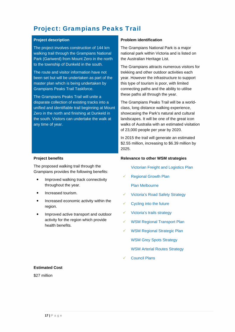
Project: Grampians Peaks Trail
Project description
The project involves construction of 144 km
walking trail through the Grampians National
Park (Gariwerd) from Mount Zero in the north
to the township of Dunkeld in the south.
The route and visitor information have not
been set but will be undertaken as part of the
master plan which is being undertaken by
Grampians Peaks Trail Taskforce.
The Grampians Peaks Trail will unite a
disparate collection of existing tracks into a
unified and identifiable trail beginning at Mount
Zero in the north and finishing at Dunkeld in
the south. Visitors can undertake the walk at
any time of year.
Problem identification
The Grampians National Park is a major national park within Victoria and is listed on the Australian Heritage List.
The Grampians attracts numerous visitors for trekking and other outdoor activities each year. However the infrastructure to support
this type of tourism is poor, with limited connecting paths and the ability to utilise these paths all through the year.
The Grampians Peaks Trail will be a world-class, long distance walking experience, showcasing the Park’s natural and cultural
landscapes. It will be one of the great icon walks of Australia with an estimated visitation of 23,000 people per year by 2020.
In 2015 the trail will generate an estimated $2.55 million, increasing to $6.39 million by 2025.
Project benefits
The proposed walking trail through the Grampians provides the following benefits:
Improved walking track connectivity
throughout the year.
Increased tourism.
Increased economic activity within the
region.
Improved active transport and outdoor activity for the region which provide
health benefits.
Relevance to other WSM strategies
Victorian Freight and Logistics Plan
Regional Growth Plan
Plan Melbourne
Victoria’s Road Safety Strategy
Cycling into the future
Victoria’s trails strategy
WSM Regional Transport Plan
WSM Regional Strategic Plan
WSM Grey Spots Strategy
WSM Arterial Routes Strategy
Council Plans
Estimated Cost
$27 million

18 | P a g e
Project: Mildura to Ports (rail standardisation)
Project description
The project involves standardising a
rail line between Mildura to the port
of Geelong and/or Portland that
travels through the Wimmera
Southern Mallee Region.
The alignment of the rail line is
dependent on the outcome of the
business case for the Murray Basin
project.
Problem identification
The efficiency of the supply chain to ports is a key issue in international competitiveness and the balance of road and rail mode share is a key issue in cost and impacts
on regional infrastructure.
The rail network provides considerable potential to alleviate the strained road network thereby balancing
the mode use to provide maximum benefits and to increase the competitiveness of logistics for the region.
The rail lines within the western area of Victoria are a
mixture of broad and standard gauges. This causes difficulty in efficiencies for rail transportation of products from this region to ports. Therefore standardising a rail
line along this corridor will help increase the competitiveness of rail.
The project is included as a recommendation within the
Murray Basin Regional Freight Demand and Infrastructure Study. The project has identified four potential rail standard gauge options that involve a
range of upgrades and are along slightly different alignments. This project has been funded for $220 million and the next step is to develop a business case
to identify the preferred option.
Project benefits
The standardisation of rail between Mildura and the Port of Geelong /
Port of Portland provides the following benefits:
Increased freight efficiency.
Reduced travel times and operating costs.
A reduction of trucks due to a
mode shift to rail.
Community amenity improvement due to fewer
vehicles on the road.
Reduced road maintenance and accidents costs.
Increased rail provider competition.
Relevance to other WSM strategies
Victorian Freight and Logistics Plan
Regional Growth Plan
Plan Melbourne
Victoria’s Road Safety Strategy
Cycling into the future
Victoria’s trails strategy
WSM Regional Transport Plan
WSM Regional Strategic Plan
WSM Grey Spots Strategy
WSM Arterial Routes Strategy
Council Plans
Estimated Cost
$220 million

19 | P a g e
Project: Horsham Bypass (Western Highway)
Project description
The Western Highway travels through the
middle of Horsham and the project
proposes to realign the highway to bypass
the township.
The alignment of the bypass has not been
set and needs to be determined to allow for
future growth of the township that is
compatible with the future realignment.
The bypass will involve constructing a new
highway to the northeast or southwest of
the township.
The bypass is likely to remove the number
of the signals that vehicles are required to
travel through when travelling along the
highway.
Problem identification
The Western Highway is a key east-west route providing the primary freight route between Melbourne, Adelaide and Perth.
The efficiency of this road corridor affects the efficiency of regional production and hence the long term viability of regional towns and
industries.
Currently the Western Highway travels through the middle of the Horsham township. This results
in through traffic along the highway having to slow down through the township and potentially stop at a number of signalised intersections.
The highway through the township increases the safety risk due to the number of vehicles (including a high percentage of heavy vehicles)
and pedestrians crossing this major highway.
Additionally, the highway creates a barrier through the township which causes connectivity
issues and divides the township. This has implications for vehicle, cyclist and pedestrian accessibility for the residents of Horsham, as well
as amenity issues.
Project benefits
The proposed Horsham Bypass (Western Highway) provides the following benefits:
Increased freight efficiency.
Reduced travel times and operating costs.
Improved road safety.
Improved connectivity and liveability for the township with the removal of
the division created by the highway.
Relevance to other WSM strategies
Victorian Freight and Logistics Plan
Regional Growth Plan
Plan Melbourne
Victoria’s Road Safety Strategy
Cycling into the future
Victoria’s trails strategy
WSM Regional Transport Plan
WSM Regional Strategic Plan
WSM Grey Spots Strategy
WSM Arterial Routes Strategy
Council Plans
Estimated Cost
TBC

20 | P a g e
Project: Capacity improvements to the Adelaide-Melbourne railway line
Project description
The project is proposed to be undertaken in a
number of stages over the short, medium and
long term to improve freight efficiency. These
steps include:
1 - 5 years - 5 new and/or extended
passing loops to 1800m.
5 - 10 years - Signalling improvements.
Replacement of 47kg rail with new
heavier rail.
10-20 years – Double stacking of rail
freight.
Problem identification
The Adelaide to Melbourne railway line is a key route for freight transportation between the two cities.
Currently train lengths are dictated by the number and length of existing passing loops, resulting in reduced capacity on the line.
Additionally, efficiency of the rail line and capacity for both freight and passenger rail to operate at realistic and convenient timeframes
is impacted by less than optimal signalling.
Ultimately the provision for double stacking of containers on rail will increase freight
efficiency with more freight being moved with fewer trains.
Project benefits
The proposed capacity improvements along
the Adelaide-Melbourne railway line provide the following benefits:
Increased number of longer trains
(1800m) are able to travel along the route.
Increased volume of freight which can
be transported per train/per train path due to the increased length of trains.
Increased number of trains that can
travel along the line.
Reduction of transit times for freight.
Higher productivity for freight vehicles
due to the increased axle loads each train can accommodate.
Relevance to other WSM strategies
Victorian Freight and Logistics Plan
Regional Growth Plan
Plan Melbourne
Victoria’s Road Safety Strategy
Cycling into the future
Victoria’s trails strategy
WSM Regional Transport Plan
WSM Regional Strategic Plan
WSM Grey Spots Strategy
WSM Arterial Routes Strategy
Council Plans
Estimated Cost
Short term stage: $25M passing loops
Medium term stage: $158M re-rail
Long term stage: TBC for signalling upgrade & double stacking.

21 | P a g e
Project: Henty Highway improvements – Horsham to Portland
Project description
Increased maintenance of the Henty Highway
is required to improve the efficiency of
commercial vehicles through to the port of
Portland.
The maintenance is primarily related to
pavement conditions such as cracking through
the pavement, potholes and shoulders
breaking away.
Problem identification
The Henty Highway is a key north-south route for the western region of Victoria and travels through the Wimmera Southern Mallee
Region. The Henty Highway connects the Sunraysia Highway in Lascelles to the Port of Portland passing through a number of
regional towns including Horsham.
The Henty Highway is classified an ‘A’ Class Road south of Horsham and a ‘B’ Class road
north of Horsham.
The section of the Henty Highway south of Horsham is a key freight route connecting
Horsham to the Port of Portland.
Many sections along this length of the road have been identified to be deteriorating due to
increased occurrences of potholes and rough patches.
Project benefits
Improved maintenance of the Henty Highway
between Horsham and Portland provides the following benefits:
Improved efficiency and reduced freight
costs.
Improved economies for freight travelling along the Henty Highway which allows
these commodities to be more competitive on the national and global market.
Improved road safety.
Efficient movement of export products to market.
Relevance to other WSM strategies
Victorian Freight and Logistics Plan
Regional Growth Plan
Plan Melbourne
Victoria’s Road Safety Strategy
Cycling into the future
Victoria’s trails strategy
WSM Regional Transport Plan
WSM Regional Strategic Plan
WSM Grey Spots Strategy
WSM Arterial Routes Strategy
Council Plans
Estimated Cost
TBC
22 | P a g e
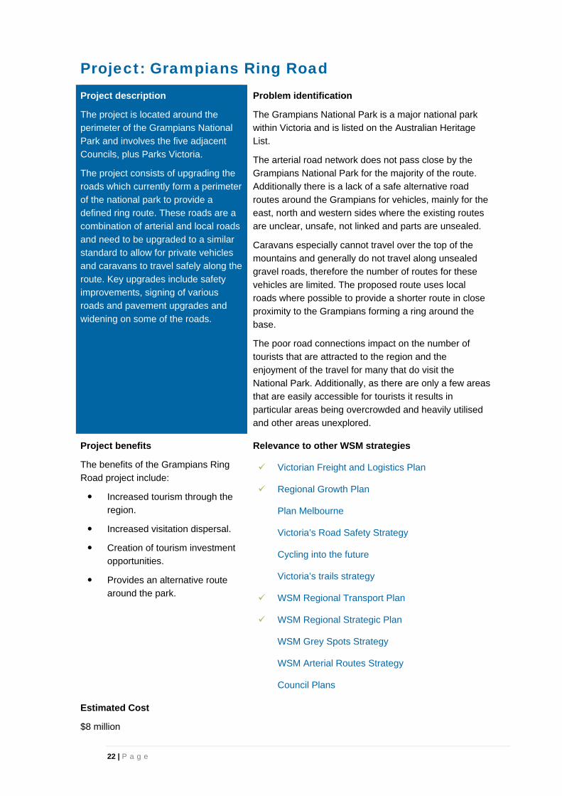
Project: Grampians Ring Road
Project description
The project is located around the
perimeter of the Grampians National
Park and involves the five adjacent
Councils, plus Parks Victoria.
The project consists of upgrading the
roads which currently form a perimeter
of the national park to provide a
defined ring route. These roads are a
combination of arterial and local roads
and need to be upgraded to a similar
standard to allow for private vehicles
and caravans to travel safely along the
route. Key upgrades include safety
improvements, signing of various
roads and pavement upgrades and
widening on some of the roads.
Problem identification
The Grampians National Park is a major national park within Victoria and is listed on the Australian Heritage List.
The arterial road network does not pass close by the Grampians National Park for the majority of the route. Additionally there is a lack of a safe alternative road
routes around the Grampians for vehicles, mainly for the east, north and western sides where the existing routes are unclear, unsafe, not linked and parts are unsealed.
Caravans especially cannot travel over the top of the mountains and generally do not travel along unsealed gravel roads, therefore the number of routes for these
vehicles are limited. The proposed route uses local roads where possible to provide a shorter route in close proximity to the Grampians forming a ring around the
base.
The poor road connections impact on the number of tourists that are attracted to the region and the
enjoyment of the travel for many that do visit the National Park. Additionally, as there are only a few areas that are easily accessible for tourists it results in
particular areas being overcrowded and heavily utilised and other areas unexplored.
Project benefits
The benefits of the Grampians Ring
Road project include:
Increased tourism through the region.
Increased visitation dispersal.
Creation of tourism investment opportunities.
Provides an alternative route around the park.
Relevance to other WSM strategies
Victorian Freight and Logistics Plan
Regional Growth Plan
Plan Melbourne
Victoria’s Road Safety Strategy
Cycling into the future
Victoria’s trails strategy
WSM Regional Transport Plan
WSM Regional Strategic Plan
WSM Grey Spots Strategy
WSM Arterial Routes Strategy
Council Plans
Estimated Cost
$8 million

23 | P a g e
Project: Rainbow rail line upgrade
Project description
The project involves upgrading the Rainbow rail
line. The project comprises of two sections. The
section of track between Dimboola and Rainbow
needs to be upgraded to carry heavier, more
efficient wagons by increasing the allowable
mass from 19 tonnes axle load to 21 tonnes
axle loads.
Higher axle loads result in more grain being
carried in each wagon and therefore improved
operating efficiency. The Melbourne-Adelaide
mainline is currently 23 tonne axle load which
means that remote sites such as Rainbow that
are restricted to 19 tonne axle load are
disadvantaged.
The section of track between Rainbow and
Yaapeet also needs to be upgraded to allow for
grain freight services. The total cost to councils
to upgrade the local road component to meet
the needs of the additional trucks and provide
the roads with a 25 year life is around $1.35
million.
Problem identification
The Rainbow rail line, between Dimboola and Rainbow, currently has a lower axle load of 19 tonnes, compared to the track it
connects to (and ultimately to the Port of Geelong) which has an axle load of 23 tonnes.
The section of track between Rainbow and Yaapeet currently does not have a regular rail freight service and needs to be upgraded
before this can occur. This results in all grain generated in the grain growing catchment of Yaapeet to be transported by road.
The upgrades of the line will provide for greater efficiency in the rail supply chain and reduce the number of trucks on the road. If
the upgrades are not completed it will impact on the road maintenance, road safety and amenity of the local communities. This would
lead to further arterial and local road upgrades to maintain the structural integrity of the roads and to accommodate the
transport of grain.
Project benefits
The benefits of the Rainbow rail line upgrade include:
Increased competitiveness for the rail transport of grain from the region. This is also likely to result in supply chain
efficiencies for the grain industry.
A reduction of trucks on the roads due to a mode shift to rail.
Community amenity improvement.
Reduced road maintenance costs.
Reduced road accident costs.
Reduced environmental externality costs.
The project is consistent with the Victorian Government objective of
growing freight on rail and the Victorian Freight and Logistics Plan (VFLP).
Relevance to other WSM strategies
Victorian Freight and Logistics Plan
Regional Growth Plan
Plan Melbourne
Victoria’s Road Safety Strategy
Cycling into the future
Victoria’s trails strategy
WSM Regional Transport Plan
WSM Regional Strategic Plan
WSM Grey Spots Strategy
WSM Arterial Routes Strategy
Council Plans
Estimated Cost
$5. 6 million – Dimboola to Rainbow. $1.7 million – Rainbow to Yaapeet.

24 | P a g e
7. Wimmera Southern Mallee regional issues and projects
The Wimmera Southern Mallee Region is a large agricultural region with a heavy reliance on road as the primary mode of transport. As a consequence there are a number of issues associated with the
transport network and the freight supply chain efficiency. The projects presented in Section 5 and 6 of this report are key specific projects for the region. However during this process a number of broader issues and projects have been identified which are not specific enough to be included within the
prioritisation process. They are still considered critical issues within the Wimmera Southern Mallee Region and require further consideration by the State. These broader projects are likely to be a combination of numerous specific smaller projects that together solve a wider issue.
The following section discusses these further issues that face the Wimmera Southern Mallee transport network.
7.1 Products to market
Many local and arterial roads play a key role in transporting goods both around and through the Wimmera Southern Mallee region. A number of these routes are not at an appropriate standard for the current freight task, in part due to issues such as width, construction standard, bridges, culverts and
alignment. In some instances these routes are unavoidable for users as they are the first and/or last mile of the freight journey.
The use of routes not fit for purpose has cost implications for both the freight companies using the
routes in loss of productivity, safety and efficiency and the road controlling authority in increased construction and maintenance costs.
The issue of local roads not being suitable for the vehicles that are travelling along these roads is
becoming more evident as the volume of on-farm storage is increasing after the deregulation of the grain industry.
Through the development of a specific plan to address moving products to market, a number of routes
have been identified that should be improved or upgraded to accommodate B-double and/or HPFV to improve efficiency and safety for freight movements and other users. However, it is critical that investment is prioritised and directed to areas of the network to serve the freight task in the most
efficient and effective manner.
A First and Last Mile Regional Freight Strategy incorporating local and arterial road routes should be prepared and would consider the freight task for the region, including freight that travels through the
region. It would examine the type and quantity of freight being moved, the mode and route it takes, factors that generate demand for freight and other relevant data. The strategy should consider both arterial and local roads and in particular address the routes that have been raised in the development
of this strategy (refer to the project listing in Appendix A).
7.2 Maintenance of ‘C’ class roads
‘C’ Class roads are essential for the road network within the Wimmera Southern Mallee Region. These
roads are of strategic importance to local government as they provide the links from the local roads to the arterial road network. They are utilised to transport freight products from local industry and agriculture between farms and the arterial network and by local residents and tourists to travel
between townships.
‘C’ Class roads are the third tier of VicRoads owned and managed roads. Maintenance of these roads is an issue due to the large number of kilometres of road to be maintained and limited maintenance
budgets for all ‘C’ Class roads throughout Victoria. Additionally, the number of large vehicles utilising

25 | P a g e
these roads to access farms and other private properties has increased significantly over the last 10 years due to many farmers owning semi-trailers and B-doubles to transport their products. These
additional large vehicles create further wear on the ‘C’ Class roads which results in pavement failure, particularly on the shoulders.
A number of deficiencies within the roads have been identified by the Wimmera Southern Mallee
Region and are outlined in the Wimmera Regional Transport Group Arterial Road (‘C’ Route) Strategy. This strategy assessed all ‘C’ Class roads within the region and identified roads that have deficiencies within the general requirements of ‘C’ Class roads which include:
Pavement seal width.
Pavement roughness.
Alignment of intersections.
Roadside hazards/vegetation management.
Edge breaks and shoulder maintenance.
Lack of consistent, delineation with centrelines and edge lines.
Narrow structures.
Isolated load limited structures.
The ongoing maintenance and improvement of ‘C’ Class roads is vital for the road network. And this
needs to be undertaken in conjunction with continual maintenance and improvements of other higher order arterial roads and local roads. There are a vast number of roads that need improvements and these upgrades and general maintenance are required to allow for efficient movement of freight, local
residents and tourists throughout the region.
7.3 Access to services
Councils have identified the need for new, improved and/or expanded public transport services within
the region, including public transport access to other parts of the state.
There are limited public transport connections for residents within smaller towns and rural areas which impacts on the accessibility of services located within larger towns. There are no passenger rail
connections within the region and bus services for many of the towns are infrequent and operate on timetables which make connection to facilities that are only offered in regional centres difficult to access. Consequently, it has been identified that there is a need to provide greater access to public
transport for connections to the regional centres (within the area) of Swan Hill, Horsham, Bendigo and Ballarat.
A key public transport accessibility issue the region has raised is the limited rail connectivity to
Melbourne and/or other key destinations within the western areas of Victoria. The region’s councils are seeking to develop a business case for the re-introduction of rail services for the Wimmera Southern Mallee and South West regions of Victoria.
It will be important for the region to continue to work closely with Public Transport Victoria in the development of any regional public transport network development plans. This will ensure that the region’s public transport needs are taken into consideration in all future public transport service
reviews and planning with early implementation of bus services in growth areas. It may also be necessary to consider other avenues to provide residents with access to services, particularly those in the smaller towns in the region.

26 | P a g e
7.4 Network Resilience
The Western Highway is the key east-west interstate route providing the primary road freight route
between Melbourne, Adelaide and Perth. The road also provides key access to and from and within the Wimmera Southern Mallee Region.
As a result of accidents and/or emergencies, there are times when the highway is closed in one or
both directions and diversions need to be put in place onto the lesser arterial routes. Due to the volume of vehicles travelling along the Western Highway and the high proportion of heavy vehicles, diversions from the highway need to be taken into consideration when planning works on these
diversion routes. Regular maintenance and additional specific treatments of these routes is required to ensure the routes are able to accommodate the traffic from the Western Highway when a diversion is required to be implemented. Treatments of these roads may include additional widening and
strengthening of the carriageway, improved line marking and other safety improvements to accommodate the level of traffic as a result of the diversion from the highway.
7.5 Rail crossing removal and upgrade program
VicTrack’s Rail Crossing Removal Program will guide the identified project for the development of a program of removal of level crossings. This program identifies Lakes Road Stawell, Stawell-Warracknabeal Road, Glenorchy; Donald-Murtoa Road, Donald; Griffith Street, Stawell; David Ave,
Nhill and Nhill-Jeparit Road, Nhill as amongst the highest priorities for attention in the Wimmera Southern Mallee. This strategy supports the ongoing implementation of this program.
7.6 Road Making Materials
The Wimmera Southern Mallee has a specific challenge related to the limited sources of quality quarry products for road construction and maintenance. Competition between various industries for the same limited construction products has resulted in increased transport construction costs. Not only does this
impact on the cost of road construction material, the impacts of moving this material from further afield has a direct impact on the transport network that it is carted on. This issue impacts on VicRoads, local council and private industry projects. More planning is required to identify quality sources within close
proximity to the Wimmera Southern Mallee to increase competition and reduce freight movements of quarry product.
7.7 Tourism
Tourism is a key generator for the region and it is highlighted within the Regional Growth Plan as an
area for growth within the Wimmera Southern Mallee Region.
A key element of tourism within the Wimmera Southern Mallee Region is focused on walking, cycling and outdoor activities. Active transport is therefore a primary element that needs to be developed and
improved to allow for the growth of this type of tourism and economic benefits for the region.
In addition to the economic driver of tourism, active transport also has many health and environmental benefits and there are a range of activities that can utilise the same transport infrastructure to
accommodate a variety of ages and physical ability.
The active transport infrastructure also allows for local communities to enjoy the area they live in, in a healthy way and/or utilising the infrastructure as a route to travel via walking or cycling.
7.8 Sustainability of the airport network
Airports are a key element of the transport network for the Wimmera Southern Mallee Region. There are a number of airports throughout the region and it is necessary to have a flexible network within the
region to allow for essential services such as the flying doctor and/or fly-in and fly-out specialist

27 | P a g e
medical practitioners. Additionally, many of the airports support economic growth of the region through growth of agricultural businesses such as crop spraying and allow for delivery of parts/supplies and/or
people for efficient use of resources within the region.
Recently CASA has completed an audit of the majority of the airports and identified a number of improvements required to be undertaken to meet the current standards for the existing or proposed
uses. While, the region acknowledges there are a number of upgrades required, each airport provides for its local area and the opportunity to build an air transport network for the region.
The airports within the region include:
Birchip.
Charlton.
Donald.
Edenhope.
Hopetoun.
Horsham.
Kaniva.
Nhill.
Patchewollock.
Sea Lake.
Stawell.
St Arnaud.
Warracknabeal.
Wycheproof.
Details of the key issues and improvements required for each airport are provided in Appendix C.
7.9 Alignment with the Murray Basin rail project (Mildura to ports rail standardisation)
This project is examining opportunities to enhance the role of rail in supporting freight movements from the Murray Basin, including to export gateways at the Victorian ports of Geelong and Portland.
It identifies opportunities to improve the productivity of the rail network to alleviate pressure on the road network through standardisation of rail gauges and providing for higher axle loads. Four options for change are identified:
A new link from Lascelles to Hopetoun and standardisation of the Mildura line north of Lascelles.
A new link from Litchfield to Minyip and standardisation of the Mildura line north of Donald.
Standardisation of the line from Geelong to Mildura (via Ballarat and Maryborough) and the branch lines to Sea Lake and Manangatang.
Standardisation of the line from Maryborough to Mildura and the branch lines to Sea Lake and
Manangatang. This option would also require refurbishment of the existing standard gauge Maryborough to Ararat line.
The Government has announced funding for the standardisation of the railway to Mildura in the 2014-
15 budget. This includes finalising the business case for the standardisation of the Mildura line which will allow network access from Mildura to Portland. It will also provide for upgrades which will support heavier train loads. In the short term there will be maintenance to the Mildura and Hopetoun lines to
ensure they are fit for purpose.
The outcomes of the project will impact on the Wimmera Southern Mallee depending on the preferred line or lines selected for standardisation. The Wimmera Southern Mallee group of councils strongly
support this project and improving rail access for the region.
The project also highlights the impacts on the road network and recommends a joint assessment of road conditions by Councils, VicRoads and DTPLI to assist in prioritisation of needs. This aligns with
the First and Last Mile Regional Freight Strategy as outlined in Section 7.1 and should be adopted to improve road freight movements through the region.

28 | P a g e
7.10 Emerging industries
7.10.1 Mineral sands
The Murray Basin region is rich in mineral resources, mineral sands exploration and mining in this
region is rapidly increasing. A key to the success of these ventures is the economic and efficient transport of product from source to processing to ports, or direct from source to ports.
Mineral sands are a bulk product and the most efficient way to shift bulk products over distance is by
rail.
To accommodate the increasing freight task that will arise from the mineral sands exploration, mining and processing upgrades to both the road and rail networks will be required to ensure the transport
network is capable of managing the task.
Planning for and development of infrastructure upgrades is supported and promoted as a vital component in the success of the mineral sands ventures.
The upgrades to the Mildura to Maryborough and Hopetoun to Murtoa lines to increase axle loads and future standardisation on the Mildura to Geelong lines will be a significant contributor to providing more efficient freight transport in the region.
Additionally specific upgrades will likely be required to accommodate projects such as the proposed WIM150 mine approximately 20 km southeast of Horsham, which is expected to produce 865,000 tonne of mineral to be exported over a 60 year time period. The mineral will be transported by road
either to the Wimmera Intermodal Freight Terminal (WIFT) at Dooen, or directly to ports.
The transportation of this material will be on a combination of local roads and arterial roads to travel between the required origins and destinations. Upgrades specific to this project will include upgrades
to roads to a standard suitable for large volumes of B-double traffic between the site and the WIFT (approx. $4m) to avoid transporting product through Horsham City and a new, or upgraded, access to the Western Highway ($ TBC) to ensure safety and efficiency for all traffic on the Western Highway.
7.10.2 Wind farms
The alternate energy sector is a growing industry within Australia and wind farms have been a key component of this sector. Wind farm operations are usually monitored remotely and therefore typically have minimal operational impacts to the road network. However, the transport infrastructure
requirements during construction are generally significant due to the large heavy components to be transported to the farm. The impacts vary depending on the size of the development and the location of the quarries used.
Larger developments require significant lengths of roads to be constructed which requires considerable volumes of construction material being sourced from quarries. The transport infrastructure impacts associated with construction of a wind farm are therefore two-fold:
1. Transportation of the wind turbines.
2. Transportation of road construction material from the quarry to the proposed site.
The management and approval of the wind farm sites will need to address the road network impacts
associated with development. The wind farm industry does not require any specific transport infrastructure to be constructed in order for sites to be progressed; however in the construction phase, the number of heavy vehicles trips greatly impacts the road condition, which then impacts the
movement of other commodities. Thus the maintenance program of current arterial roads needs to consider construction programs and allocate funding accordingly. Traffic Management Plans (TMPs) and onsite quarrying are two elements that need to be considered carefully to minimise the impacts on
the local road network. These processes require approval from the relevant local councils and state government authorities.

29 | P a g e
Appendices

30 | P a g e
Appendix A – Project list

31 | P a g e
Project Title Strategy/ Infrastructure
Mode of Transport
Project Description Problem Identification Estimated Cost
Expected timing
Western Highway duplication to Stawell (Buangor to Stawell)
Infrastructure Road Duplicate the Western Highway between Buangor and Stawell which includes provision for two lanes in each direction with a central median. Intersection upgrades to improve road safety and facilitate the efficient movement of traffic are also planned.
The Western Highway is a key east-west route providing the primary freight route between Adelaide and Melbourne.
$500 million Short (0-5 yrs)
Western Highway safety and efficiency improvements - Stawell to SA border
Infrastructure Road Improved overtaking opportunities along the Western Highway with possible improvements such as 2+1 or 2+2 in particular places
The increasing traffic volumes on the Western Highway result in reduced safe opportunities to overtake. The ultimate effect is that cost to move freight is increasing
TBC Medium (5-15 yrs)
Henty Hwy improvements - Horsham to Lascelles.
Infrastructure Road The project involves sealing shoulders and improving roughness along the Henty Highway from Horsham through to Lascelles
Commercial vehicles need to travel at reduced speeds to be able to stay within the sealed section of the highway, resulting in these vehicles regularly veering onto the unsealed shoulder which creates pavement drop offs and increases maintenance costs
$16 million Medium (5-15 yrs)
Grampians Peaks Trail Infrastructure Active Transport
The project involves construction of 144 km walking trail through the Grampians National Park (Gariwerd) from northern extent to southern extent of park.
Poor infrastructure to support trekking tourism through the Grampians National Park. The Grampians Peaks Trail will unite a disparate collection of existing tracks into a unified and identifiable trail beginning at Mount Zero in the north and finishing at Dunkeld in the south. Visitors will be able to undertake the walk at any time of year.
$ 27 million Medium (5-15 yrs)
Mildura to Ports Rail Standardisation
Infrastructure Rail Standardisation of the Mildura Rail line for a direct rail link to Portland and Geelong Ports for export freight
Improve the efficiency of the supply chain to ports with a balance between road and rail. Provide cost effective access to Ports of Portland and Geelong. Provide potential to alleviate the strained road network moving containerised produce from Mildura and Donald Intermodal, containerised mineral sands from Mallee Sand Mines and bulk grain export from grain receival facilities along the line.
$220 million Short (0-5 yrs)
Horsham Bypass Infrastructure Road Realign the Western Highway within the vicinity of Horsham to bypass the township
The Western Highway forms the key road link between Melbourne and Adelaide and connects the regional centres along the corridor with services and the sales and export markets for goods produced in the region. The efficiency of this road corridor affects the efficiency of regional production and hence the long term viability of regional towns and industries. The key problems being addressed are safety and freight efficiency.
TBC Long (15+ yrs)

32 | P a g e
Project Title Strategy/ Infrastructure
Mode of Transport
Project Description Problem Identification Estimated Cost
Expected timing
Capacity improvements to the Adelaide - Melbourne railway line
Infrastructure Rail 1 to 5 years - 5 New and/or extended passing loops to 1800m 5 to 10 years - Signalling Improvements Replacement of 47kg rail with new heavier Rail 10 to 20 years - Double stacking of rail freight
Currently train lengths are dictated by the number and length of existing passing loops, resulting in reduced capacity on the line. Less than optimal signalling and rail capacity impacts on rail efficiency and capacity for freight and passenger rail. Ultimately the provision for double stacking of containers on rail will increase freight efficiency with more freight being moved with fewer trains.
$25M passing loops $158M re-rail TBC for signalling upgrade & double stacking.
Short (0-5 yrs) and Medium (5-15 yrs)
Henty Hwy Improvements - Horsham to Portland
Infrastructure Road Increased maintenance of the Henty Highway to improve the efficiency of commercial vehicles through to the port.
The Henty Highway is deteriorating due to increased high heavy vehicle use and the subsequent occurrences of potholes and rough patches.
TBC Short (0-5 yrs)
Grampians Ring Road Infrastructure Road-Passenger/Private
The project is located around the perimeter of the Grampians National Park and would involve all five adjacent Councils, plus Parks Victoria. The project consists of the road upgrades, safety improvements and signing of various arterial and local roads to create a defined ring route around the outer base of the Grampians Ranges.
The arterial road network does not pass close by the Grampians National Park for the majority of the route. There is a lack of a safe alternative road route around the Grampians for vehicles, mainly for the east, north and western sides where the existing routes are unclear, unsafe, not linked and parts are unsealed. Many Grampians attractions are accessible only via gravel or other un-sealed roads. Caravans especially cannot travel over the top of the mountains and are not suited to gravel roads. The proposed route uses local roads where possible to provide a shorter route in close proximity to the Grampians. Poor infrastructure to support access to and promotion of tourist attractions around the Grampians National Park. Development of a tourist route will encourage tourist attraction and dispersal and the further development of existing tourist attractions.
$8 million Medium (5-15 yrs)
Dimboola to Rainbow rail line axle load upgrade
Infrastructure Rail-Freight The project involves upgrading the rail tracks to carry heavier, more efficient wagons by increasing the allowable mass from 19 tonnes axle load (TAL) to axel 21 TAL.
Higher axle loads result improved operating efficiency. The ARTC mainline is currently 23 TAL which means that remote sites such as Rainbow, which are restricted to 19 TAL, are disadvantaged. The result is grain is tending to bypass the Rainbow site resulting in underutilisation of the up-country grain handling facilities and more freight on country roads.
$5.6 million Short (0-5 yrs)

33 | P a g e
Project Title Strategy/ Infrastructure
Mode of Transport
Project Description Problem Identification Estimated Cost
Expected timing
Rainbow-Yaapeet Rail Line Upgrade
Infrastructure Rail-Freight The proposed project aims to upgrade the section of rail line from Rainbow to Yaapeet to allow rail freight services, in particular grain transportation, between Rainbow and Yaapeet.
The inability to use the Rainbow to Yaapeet section of rail line for grain haulage forces all grain generated in the Yaapeet catchment to be transported from Yaapeet by road. The total cost to Councils to upgrade the local road component to meet the needs of these truck movements and provide the roads with a 25 year life is approx. $1.35M. The forecast cost to local government to maintain the local road component of the haul roads in their current state of construction and the structural integrity of the recently constructed component to cater for the increase in traffic between Yaapeet Silos and Rainbow Rail Siding is $126,550 p/a. The forecast cost to VicRoads to widen and strengthen the arterial road component of the haul roads the two silos to cater for the increase in traffic is $4.68M over 5 years, with another $4m in years 6 to 10. This cycle starts again after 25 years.
$1.7 million Short (0-5 yrs)
Stawell to Halls Gap Walking/Cycling Route
Infrastructure Active Transport
Between Stawell West and Halls Gap, and between Halls Gap and Pomonal. The extent of the project is to construct extensions to existing bicycle / foot paths to link these 3 key tourist destinations.
The problem to be addressed is the lack of a safe route for cyclists between these destinations. The current route is along two very busy arterial roads, both of which have narrow seal widths and unsealed shoulders for the majority of their length. A section of the Stawell to Halls Gap route [Grampians Rd] was widened recently, but it still has narrow shoulders and the rumble strip edge lines have not been moved out any appreciable distance, so it is still unsafe for inexperienced riders. Recreational cycling and walking is increasing in use, and is particularly relevant to the tourist destinations of Halls Gap and Pomonal. Visitors are ready and prepared for a recreational experience and have the time to undertake exploring the regions features by foot or bicycle. Halls Gap has several large school and church camps which all regularly use the existing path network throughout the year as part of their programs. The need for increased paths has been identified for many years and Council has been steadily adding to the Halls Gap path network. The Stawell Secondary College has constructed many kilometres of the Stawell end of the path over the past 10 years. This project would link them all together. Backpackers, families and children could all use a safe route away from the arterial road. The success of this approach has been demonstrated by the Halls Gap off-road path which now extends a total distance of around 8kms from the northern edge of Halls Gap through to the Bellfield dam.
TBC Short (0-5 yrs)

34 | P a g e
Project Title Strategy/ Infrastructure
Mode of Transport
Project Description Problem Identification Estimated Cost
Expected timing
Calder Hwy “Y” Intersections - Sea Lake to Nandaly
Infrastructure Road Squaring up of 4 poorly aligned Y intersections of local roads/arterial roads intersecting the: - Calder Hwy between Sea Lake and Nandaly. - Calder Hwy / Baileys Rd (sealed) - Calder Hwy / Ninda – Turriff Rd (sealed) - Calder Hwy / Patchewollock – Sea Lake Rd (sealed) - Calder Hwy / Elliots Rd (gravel)
Road Safety Risk; Y intersections that impact on desirable sight lines is a high risk on high speed rural roads. Ideally, all Y intersections should be squared up to maximise sight lines.
$500,000 Short (0-5 yrs)
Calder Hwy Improvement – Wycheproof to Sea Lake
Infrastructure Road Improve pavement to eliminate roughness and pavement failures.
Calder Hwy within Buloke Shire has very rough pavement and in recent times has deteriorated at a rapid rate. The level of roughness and amount of minor pavement failures makes the ride between Wycheproof and Sea Lake very uncomfortable for the high volume of heavy vehicles, commercial vehicles and cars/caravans.
$2 million Short (0-5 yrs)
Western Victorian Iconic Walking Trail (Horsham, Hindmarsh and West Wimmera).
Strategy/Study Active Transport
The project is the staged establishment of a walking trail approximately 140 km in length comprising rail trail, roadside trails and existing tracks. It includes camping facilities (walkers only), signage and interpretative material for local tourism opportunities and the natural environment. The project is from Horsham to Mount Arapiles to Lake Hindmarsh via Goroke, Little Desert National Park, Dimboola and Wimmera River. There are three parts to the project. Part A – Feasibility Study Part B – Master Plan Part C – Construction
The project addresses the lack of connected tourism infrastructure associated with the natural attractions of Little Desert National Park and the Wimmera River
Part A $ 80,000 Part B - $120,000 Part C $14 million
Short (0-5 yrs) for the planning study
Hindmarsh Walking Trail Project
Infrastructure Active Transport
The project includes a walking trail along the Wimmera River from Dimboola to Lake Hindmarsh. The project will connect existing camping areas and provide a cultural heritage tour of significant sites along the river and the location of the first approved native title.
There are limited walking opportunities within Hindmarsh Shire and this trail links existing areas to allow visitors to explore the area beyond the immediate camp site area. The WSM Region requires tourism growth and there are limited tourist attractions outside of the Grampians.
$300,000 0
Sea Lake Airport Upgrade
Infrastructure Air The project aims to upgrade and improve safety at the existing Sea Lake airport by providing a wider runway, a better surface for the unsealed main runway (09/27), grading of the taxiway (smoother surface) and a new wind sock.
CASA has identified that upgrades of the Sea Lake Airport are required to meet the CASA Design Standards. Recent inspections have identified that urgent maintenance action is required on the movement areas including: weed removal, pavement repairs and surface improvements on the main runway. Unserviceability crosses are required to properly prepare for a runway closure and there is a need for a windsock.
$250,000 Short (0-5 yrs)

35 | P a g e
Project Title Strategy/ Infrastructure
Mode of Transport
Project Description Problem Identification Estimated Cost
Expected timing
Stawell Airport Infrastructure Air The project is based around the Stawell Airport, Airport Rd, Stawell. The project includes future upgrades and extensions to airside infrastructure and associated non-airside facilities, plus planning controls to protect aircraft approaches and take-off surfaces.
Existing airport was constructed in 1963 and few improvements were made until 4 stages of a major upgrade costing around $4M were undertaken from 2010 to 2014. Those works have resulted in increased usage and expansion of businesses at the airport, as well as upgraded airport infrastructure and aircraft safety improvements. Further planning is underway to undertake additional upgrades to encourage new business opportunities and enhance existing operators at the airport. In addition, DEPI is proposing to invest upwards of $0.5M on the existing fire base at the airport with upgraded facilities and airside works. The airport environs and aircraft circuit areas also need to be protected from inappropriate development that could restrict, endanger or affect the operation of aircraft at and around the airport. This work would involve changes to the planning scheme.
TBC Short (0-5 yrs)
Passenger Rail Extension (shuttle rail service between Kaniva, Horsham and Ararat)
Strategy/Study Rail-Passenger/Private
An assessment to identify the feasibility to provide a shuttle rail service between Kaniva and Ararat to meet with the existing rail service between Melbourne and Ararat.
The existing passenger service from Melbourne to the region is by train to Ararat, and then by bus. The higher quality of service available by rail, compared to buses is highly valued by passengers. While the current overland service between Melbourne and Adelaide stops at towns within the WSM Region, the service is infrequent and therefore is not convenient for day trips to Melbourne.
$100,000 Short (0-5 yrs)
Dimboola to Rainbow Road
Infrastructure Road-Freight
The project involves widening narrow sections of the road.
The road has been identified to have a high volume of vehicles travelling along the road compared to other 'C' Class roads within the WSM Region (AADT 1,760, CV 180). Additionally, the road is a key north-south truck route for the shire. Based on the recorded traffic volumes, it has been identified that the road is too narrow for the volume of vehicles utilising the road and needs to be widened to have sufficient pavement width to allow for a traffic lane in each direction.
TBC Short (0-5 yrs)
Seven Mile Road Infrastructure Road-Freight
The project involves a full reconstruction of the road to a sealed two carriageway. Seven Mile Road is located between St Arnaud-Wycheproof Road and River Road
Seven Mile Road is an east-west freight route providing better access to markets for local producers of grain and quarry products. The road also serves as a primary access from Donald to the Charlton feedlot. The existing gravel road does not provide sufficient carriageway pavement for vehicles to operate without a heavy vehicle imposing a risk on other road users by impinging on adjacent lanes or encroaching on areas with limited or no shoulders.
$2.3 million Short (0-5 yrs)

36 | P a g e
Project Title Strategy/ Infrastructure
Mode of Transport
Project Description Problem Identification Estimated Cost
Expected timing
Charam-Wombelano Road Upgrade to 6.2m width, Wimmera Hwy to Goroke-Harrow Road
Infrastructure Road-Freight
The project involves widening, upgrading and strengthening the road pavement from one sealed traffic lane to two sealed traffic lanes to cater for B-Doubles. The project is located on Charam Wombelano Rd between Wimmera Hwy and Goroke Harrow Rd.
The existing narrow seal does not provide sufficient carriageway for vehicles to operate without a heavy vehicle imposing a risk to other road users by impinging on adjacent lanes or encroaching on limited or no shoulders. Charam Wombelano Rd carries 120 vpd with 30%CV.
$4.4 million Short (0-5 yrs)
Edenhope-Coleraine Road and the Wimmera Highway Intersection Improvements (C-class roads intersection)
Infrastructure Road-Freight
The projects involves realignment of intersections and advance warning signage to reduced approach speeds and improve provision for heavy vehicles to turn toward Horsham from the Coleraine Road and improved slip lane for left hand turn from Horsham direction.
The intersection has a poor layout with a number of uncontrolled points of conflict.
$60,000 Short (0-5 yrs)
Goroke-Harrow Road Upgrade from Wimmera Highway to Nhill-Harrow Road
Infrastructure Road-Freight
The project involves widening, upgrading and strengthening the road pavement from one sealed traffic lane to two sealed traffic lanes to cater for B-Doubles.
The existing narrow seal does not provide sufficient carriageway for vehicles to operate without a heavy vehicle imposing a risk to other road users by impinging on adjacent lanes or encroaching on areas with limited or no shoulders.
$5 million Medium (5-15 yrs)
Coleraine Edenhope Rd Upgrade, south of Harrow (C-class road)
Infrastructure Road-Freight
The project is from Harrow to Coleraine and involves pavement widening, shoulder construction and safety improvements.
The existing narrow seal does not provide sufficient carriageway for vehicles to operate without a heavy vehicle imposing a risk to other road users by impinging on adjacent lanes or encroaching on areas with limited or no shoulders.
TBC Short (0-5 yrs)
Harrow Goroke Road and Nhill Harrow Rd
Infrastructure Road-Freight
The project provides intersection improvements including realignment and pavement widening.
The intersection is a ’Y’ intersection. Drivers of heavy freight vehicles on Harrow Goroke Rd cannot sight to the left hand side for approaching vehicles.
$100,000 Short (0-5 yrs)
Nhill-Harrow Road / Wimmera Highway
Infrastructure Road-Freight
The project is a realignment of a cross road intersection to a ‘Right-Left Staggered T Intersection’.
The problem is an angled cross-road intersection layout. $500,000 Short (0-5 yrs)
Nhill-Harrow Road Upgrade from Miga Lake Access Road to Coleraine Edenhope Rd and through Hindmarsh Shire Council to Nhill
Infrastructure Road-Freight
The project involves widening the road pavement from one sealed traffic lane to two sealed traffic lanes, and from narrow sealed two lane road to design standard sealed two lane road.
Nhill Harrow Rd is a north-south freight route through the municipality providing access to markets for local producers of grain and quarry products. It carries 120 vpd with a 17% CV. The existing narrow seal does not provide sufficient carriageway for vehicles to operate without a heavy vehicle imposing a risk to other road users by impinging on adjacent lanes or encroaching on areas with limited or no shoulders.
$4 million Short (0-5 yrs)
Serviceton North Telopea Downs Road / Western Highway Intersection
Infrastructure Road-Freight
Acceleration (slip) lanes on Western Hwy on the eastern side of the intersection.
Line of sight is restricted and slow heavy vehicles entering Western Hwy can pose a hazard to high speed Western Hwy traffic. Safety concerns cause some freight to take other less ‘fit for purpose’ routes.
$700,000 Medium (5-15 yrs)

37 | P a g e
Project Title Strategy/ Infrastructure
Mode of Transport
Project Description Problem Identification Estimated Cost
Expected timing
Kaniva-Edenhope Road Upgrade (‘C’ class road)
Infrastructure Road-Freight
The project is from Kaniva (Western Highway intersection) to Edenhope (Wimmera Highway intersection) and involves pavement widening, shoulder construction and safety improvements, upgrading of curved sections to meet a 100km/h standard, pavement rehabilitation to address unacceptable pavement roughness, and pavement strengthening on the road to cope with the increase in heavy vehicle volumes.
The existing narrow seal on curves does not provide sufficient carriageway for vehicles to operate without a heavy vehicle imposing a risk to other road users by impinging on adjacent lanes or encroaching on areas with limited or no shoulders. Poor pavement quality affects freight efficiency and safety.
TBC Medium (5-15 yrs)
Sunraysia Highway Improvements - between Pearses Road (south of Donald) to Russell Road (north of Donald)
Infrastructure Road The project involves sealing the shoulders and installing tactile edge lines and RRPM's along a 10km section of Sunraysia Highway between Pearses Road (south of Donald) to Russell Road (north of Donald). The project also includes sealing intersection bell mouths and removing hazards that are within the clear zone.
Four of the five recorded accidents along this section of road were run-off-road accidents. Three of the accidents involved vehicles leaving the carriageway on the right side, another involved leaving the carriageway on a right bend and one involved a vehicle leaving the carriageway on the left side. The other accident involved a pedestrian. All of the accidents occurred during daylight hours and in dry conditions.
TBC Short (0-5 yrs)
Charlton Borung Road Freight Route
Infrastructure Road-Freight
The project involves widening the road pavement from one sealed traffic lane to two sealed traffic lanes.
Charlton Borung Road is an east-west freight route providing access to markets for local producers of grain and quarry products. The road has a high proportion of heavy vehicles and the narrow seal does not provide sufficient carriageway for vehicles to operate without a heavy vehicle imposing a risk to other road users by impinging on adjacent lanes or encroaching on areas with limited to no shoulders.
TBC Short (0-5 yrs)
Watchupga Culgoa Road
Infrastructure Road-Freight
The project involves a full construction of the road to a sealed single lane carriageway. Watchupga Culgoa Road is located between Birchip-Sea Lake Road and Berriwillock-Birchip Road.
Watchupga Culgoa Road is an east-west freight route providing better access to markets for local producers of grain and quarry products. The existing gravel pavement does not provide sufficient carriageway for vehicles to operate without a heavy vehicle imposing a risk on other road users by impinging on adjacent lanes or encroaching on limited areas with or no shoulders.
$3.8 million Short (0-5 yrs)
Banyena Pimpinio Road Freight Route
Infrastructure Road-Freight
The project involves widening the road pavement from one sealed traffic lane to two sealed traffic lanes. Banyena Pimpinio Road is situated between Banyena Silo Road and Yarriambiack Creek.
Banyena Pimpinio Rd is an east-west freight route through the municipality providing better access to markets for local producers, i.e. grain, seed and legumes from farm to receival centres. Banyena Pimpinio Rd carries 53 vpd with a 12% CV. The existing narrow seal does not provide sufficient carriageway for vehicles to operate without a heavy vehicle imposing a risk to other road users by impinging on adjacent lanes or encroaching on limited areas with or no shoulders.
$6 million Short (0-5 yrs)

38 | P a g e
Project Title Strategy/ Infrastructure
Mode of Transport
Project Description Problem Identification Estimated Cost
Expected timing
Lascelles West Road between Hopetoun Walpeup Road and Sunraysia Hwy and Sea Lake Lascelles Road between Sunraysia Hwy and Ninda South West
Infrastructure Road-Freight
The project involves widening the road pavement from one sealed traffic lane to two sealed traffic lanes. The project is located on Lascelles West Road between Hopetoun Walpeup Road and Sunraysia Highway, and Sea Lake Lascelles Road between Sunraysia Highway and Ninda South West School Road It is also a school and road freight route.
Lascelles West Rd and Sea Lake Lascelles Rd is an east-west freight route through the municipality providing better access to markets for local producers of grain and quarry products. Lascelles West Rd and Sea Lake Lascelles Rd carry 60 vpd with a 40% CV. The existing narrow seal does not provide sufficient carriageway for vehicles to operate without a heavy vehicle imposing a risk to other road users by impinging on adjacent lanes or encroaching on areas with limited or no shoulders.
$5.5 million Short (0-5 yrs)
Longerenong Road Freight Route
Infrastructure Road-Freight
The project involves widening the road pavement from one sealed traffic lane to two sealed traffic lanes. Longerenong Road is situated between Murtoa Glenorchy Road and Yarriambiack Creek.
Longerenong Rd is an east-west freight route through the municipality providing better access to markets for local producers of grain. There are major grain receival centres located near each end of the road. Longerenong Rd carries 212 vpd with a 13.3% CV. The existing narrow seal does not provide sufficient carriageway for vehicles to operate without a heavy vehicle imposing a risk to other road users by impinging on adjacent lanes or encroaching on areas with limited or no shoulders.
$1.3 million Short (0-5 yrs)
Dimboola Minyip Road Freight Route
Infrastructure Road-Freight
The project involves widening the road pavement from one sealed traffic lane to two sealed traffic lanes. The project is located on Dimboola Minyip Road between Geodetic Road and Henty Highway, and Minyip Dimboola Road between Henty Highway and Stawell Warracknabeal Road.
Dimboola Minyip Road and Minyip Dimboola Road have been identified as an east-west freight route through the municipality linking central Victoria to western Victoria and South Australia. It provides a route between Dimboola and St Arnaud that avoids major towns on the arterial network. Both roads carry 300 vpd with a 35% CV. The existing narrow seal does not provide sufficient carriageway for vehicles to operate without a heavy vehicle imposing a risk to other road users by impinging on adjacent lanes or encroaching on areas with limited or no shoulders.
$4.3 million Short (0-5 yrs)
Banyena Minyip Road Freight Route
Infrastructure Road-Freight
The project involves widening the road pavement from one sealed traffic lane to two sealed traffic lanes. Banyena Minyip Road is situated between Stawell Warracknabeal Road and Burrum Lawler Road, Minyip.
Minyip Banyena Rd has been identified as an east-west freight route through the municipality linking central Victoria to western Victoria and South Australia. It carries 300 vpd with a 35% CV. The existing narrow seal does not provide sufficient carriageway for vehicles to operate without a heavy vehicle imposing a risk to other road users by impinging on adjacent lanes or encroaching on areas with limited or no shoulders.
$1 million Short (0-5 yrs)
Stawell Warracknabeal Rd Rail Crossing at Minyip
Infrastructure Road The project involves the signalisation of the rail crossing. The project is located on Stawell Warracknabeal Road rail crossing near Minyip.
Stawell Warracknabeal is a ‘B’ route under VicRoads road hierarchy and carries 90 heavy freight vehicles per day. The road speed limit reduces from 100km/h to 80km/h for the rail crossing. It is a major freight route for grain in and through the region. The rail crossing is controlled by a Stop sign on one approach requiring all vehicles to come to stop on a major rural road.
$800,000 Short (0-5 yrs)

39 | P a g e
Project Title Strategy/ Infrastructure
Mode of Transport
Project Description Problem Identification Estimated Cost
Expected timing
WIM 150 Route Infrastructure Road The project is implementation of upgrades of the transport network near Horsham to facilitate the development of a major, long-term regional mining site.
Australian Zircon has announced the development of the WIM 150 mineral sands approximately 20 km southeast of Horsham. It is expected to produce 865,000 tonne of mineral to be exported. The mineral will be transported by road either to the Wimmera Intermodal Freight Terminal (WIFT) at Dooen, or directly to port. The developer will be required to use local roads to access the arterial road network. These local roads will require significant upgrades and ongoing maintenance. If the option to rail freight from WIFT is pursued, the only arterial road route option to the terminal is through Horsham, affecting the amenity of the city.
$4 million Short (0-5 yrs)
Nature Tracks – Pedestrian and Cycling Facilities within Buloke Shire.
Infrastructure Active Transport
Links between regional towns and natural features/nature walks that provide safe and low maintenance infrastructure to cater for the pedestrian and bicycle needs to access and circulate the shires nature walks. i.e.… - Watchem to Lake Watchem - Birchip to Lake Tychum - Sea Lake to Green Lake - Donald River Walk - Charlton River Walk/Weir
The existing facilities that serve the community and tourists that link the Shire’s towns with natural features/nature walks must be fit-for-purpose. The current level of infrastructure is below standard and in need of improvement to meet current demands.
$800,000 Short (0-5 yrs)
Culgoa Walking Trail Infrastructure Active Transport
The proposed walking path will provide a pedestrian facility that connects the township of Culgoa to the sporting oval facilities and playground at the school before returning to the township. The walking path itself will be a new recreational facility, and will improve pedestrian access to football, netball and playground facilities. User groups will include parents with prams, toddlers on bicycles, teenage and adult cyclists, large groups of walkers and dog walkers, altogether constituting a large percentage of the town’s population.
The existing facilities that serve the community and tourists that link the towns with community facilities must be fit-for-purpose. The current level of infrastructure is below standard and in need of improvement to meet current demands.
$200,000 Short (0-5 yrs)
Sea Lake Walking Trail Infrastructure Active Transport
The proposed walking path will provide a pedestrian facility that circumnavigates the township of Sea Lake and connects to the golf course, sporting oval facilities and playground, before returning to the township. The walking path itself will be a new recreational facility, and will improve pedestrian access to football, netball and playground facilities. The project has been developed with the Landcare group to provide an environmental walking trail.
The existing facilities that serve the community and tourists that link the towns with community facilities must be fit-for-purpose. The current level of infrastructure is below standard and in need of improvement to meet current demands.
$200,000 Short (0-5 yrs)

40 | P a g e
Project Title Strategy/ Infrastructure
Mode of Transport
Project Description Problem Identification Estimated Cost
Expected timing
Wycheproof Walking Trail
Infrastructure Active Transport
It is proposed to construct a car park on the south side of Charles Street and approximately 1.2 kilometres of walking path to provide three paths to the top of Mount Wycheproof. The paths would commence at the school, adjacent the bus shelter in Show Street and at a proposed car park on the south side of Charles Street. The proposed car park will provide two bus parks and approximately 8 car parks. The paths will meander from the three starting points to the top of Mt Wycheproof, with a circuit around the tower. The proposal also includes the provision of bench seats for rest breaks at the car park and on top of the mountain, and for a series of fitness equipment pieces to encourage use of the path as a fitness track and overall workout.
The existing facilities that serve the community and tourists that link the towns with community facilities must be fit-for-purpose. The current level of infrastructure is below standard and in need of improvement to meet current demands. The proposed walking path will provide a recreational facility that connects existing footpaths from the township of Wycheproof to the top of Mount Wycheproof. The proposed project has been promoted by the ‘Friends of the Mount’ group at Wycheproof.
$200,000 Short (0-5 yrs)
Stawell Bypass Infrastructure Road The ultimate project is the bypass of Stawell. However an interim treatment is road improvement works such as variable day/night speed limits to assist with movement of night time freight whilst providing a safe environment during the day with lower speed limits.
The Western Highway forms the key road link between Melbourne and Adelaide and connects the regional centres along the corridor with services and the sales and export markets for goods produced in the region. The efficiency of this road corridor affects the efficiency of regional production and hence the long term viability of regional towns and industries. This project will address the problems of safety and freight efficiency.
TBC Short (0-5 yrs)
Henty Highway (Dooen Road) – Searle Street Intersection
Infrastructure Road-Freight
The project involves: - Installation of improved traffic control and pedestrian crossings. - The works would probably include kerb realignments, median safety zone installation, line marking, and road signs.
Reduced collisions, and therefore casualties. Searle St is identified as a collector road in HRCC’s Road Management Plan. However, the community is accessing it to a greater extent than its status in the road hierarchy suggests. It serves as a short-cut from areas north of the Western Highway (Baillie St) in central Horsham, and the Horsham North area to connect through to the Horsham 298 and Lutheran primary schools in the northeast of Horsham. Vehicles accessing this route have to negotiate the complex intersection which includes Dooen Road (Henty Highway), Sunnyside Avenue, Caroline St and Searle St. These three side roads are poorly aligned leading to increased collision risk at the intersection.
$300,000 Short (0-5 yrs)

41 | P a g e
Project Title Strategy/ Infrastructure
Mode of Transport
Project Description Problem Identification Estimated Cost
Expected timing
Birchip-Corack Road Infrastructure Road-Freight
The project involves widening the road pavement by 1.2m. Birchip Corack Road is located between the Sunraysia Highway and Donald-Swan Hill Road.
Birchip Corack Road is a local north-south road that is currently being used by highway traffic (including freight) due to the poor condition of the pavement on the Sunraysia Highway.The existing narrow seal does not provide sufficient carriageway for vehicles to operate without a heavy vehicle imposing a risk on other road users by impinging on adjacent lanes or encroaching on areas with limited or no shoulders.
$2.3 million Short (0-5 yrs)
Donald Murtoa Road Infrastructure Road-Freight
The project involves the upgrade of two sections of the road which include: - A 1.592km section between chainages 28.152km to 29.744km. This section of road needs to be reconstructed to improve pavement conditions. - A 1.737km section between chainages 38.884km to 40.621km. This section of road needs to be reconstructed to improve pavement conditions.
The Donald Murtoa Road is a ‘C’ Class road, which is a significant northeast to southwest link. The road provides a connection between Sunraysia Highway (Donald) and Wimmera Highway (Murtoa) and connects to the Henty Highway and the Western Highway. Additionally, the road provides a connection to the Port of Portland. Sections of the road have been identified to be in poor condition which impact on the efficiency and safety of vehicles travelling along the road, particularly large freight vehicles. The key issues with the pavement condition are roughness and failing pavement.
$1 million Short (0-5 yrs)
Horsham to Natimuk Regional Cycling Trail Project
Infrastructure Active Transport
The project involves construction of a 25km walking and cycling trail to connect Horsham and Natimuk via active transport modes.
There is no connection between Horsham and the Natimuk – Arapiles bike trail. Horsham is the major transport, accommodation and retail hub. There is limited public transport provided between the towns and this provides an alternative mode of transport.
$5 million Short (0-5 yrs)
Horsham to Green Lake Regional Cycling Trail Project
Infrastructure Active Transport
The project involves construction of a 10 km walking and cycling trail to connect Horsham and Green Lake via active transport modes.
This project connects Horsham to the recreational facilities at Green Lake. There is limited public transport provided between the towns and this provides an alternative mode of transport.
$1.5 million Short (0-5 yrs)
Horsham to Dooen Regional Cycling Trail project
Infrastructure Active Transport
The project involves construction of a 9 km walking and cycling trail to connect Horsham and Dooen via active transport modes.
This project provides a safe off-road route to Dooen. There is limited public transport provided between the towns and this provides an alternative mode of transport.
$1.3 million Short (0-5 yrs)
Sunraysia Highway Improvements north of Curyo and southeast of Donald
Infrastructure Road The project involves rehabilitation work on the pavement to address roughness for 2 km of road length in the following locations: 530m past 360km marker to 32m past 361km marker, north of Curyo and southeast of Donald: 500m past 276km marker to 210m past Morgans Road.
The pavement roughness has been identified as a key issue which results in a poor ride quality and safety impacts. Sections of the Sunraysia Highway have been identified to have a pavement roughness that is unacceptable for the user.
TBC Short (0-5 yrs)
Mildura Passenger Service
Infrastructure Rail-Passenger/Private
Return of passenger service. Mildura currently can only be accessed by bus or by flying, however flying is rather expensive and the buses can be uncomfortable and restricted as the travel time is approximately 6 hours. Therefore the majority of people travelling to and from Mildura drive. A train service provides passengers with the opportunity to not drive whilst providing comfort for the long journey.
TBC 0
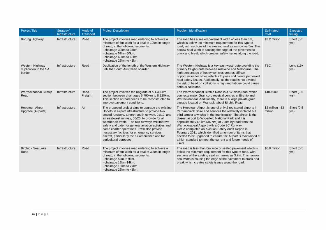
42 | P a g e
Project Title Strategy/ Infrastructure
Mode of Transport
Project Description Problem Identification Estimated Cost
Expected timing
Borung Highway Infrastructure Road The project involves road widening to achieve a minimum of 6m width for a total of 10km in length of road, in the following segments: - chainage 32km to 34km. - chainage 57km-60km. - chainage 60km to 65km. - chainage 28km to 41km.
The road has a sealed pavement width of less than 6m, which is below the minimum requirement for this type of road, with sections of the existing seal as narrow as 5m. This narrow seal width is causing the edge of the pavement to crack and break which creates safety issues along the road.
$2.2 million Short (0-5 yrs)
Western Highway duplication to the SA border
Infrastructure Road Duplication of the length of the Western Highway until the South Australian boarder.
The Western Highway is a key east-west route providing the primary freight route between Adelaide and Melbourne. The high percentage of heavy vehicles creates difficult opportunities for other vehicles to pass and create perceived road safety issues. Additionally, as the road is not divided the risk of head on collisions is high and fatigue could cause serious collisions.
TBC Long (15+ yrs)
Warracknabeal Birchip Road
Infrastructure Road-Freight
The project involves the upgrade of a 1.330km section between chainages 6.790km to 8.120km. This section of road needs to be reconstructed to improve pavement conditions.
The Warracknabeal Birchip Road is a ‘C’ class road, which connects major Graincorp receival centres at Birchip and Warracknabeal. Additionally, there is a large private grain storage located on Warracknabeal Birchip Road.
$400,000 Short (0-5 yrs)
Hopetoun Airport Upgrade (Airports)
Infrastructure Air The proposed project aims to upgrade the existing Hopetoun airport infrastructure to provide two sealed runways, a north-south runway, 01/19, and an east-west runway, 08/26, to provide for all weather air traffic. The two runways will improve safety and cater for general aviation activities and some charter operations. It will also provide necessary facilities for emergency services aircraft, particularly the air ambulance and for agricultural purposes.
The Hopetoun Airport is one of only 2 registered airports in Yarriambiack Shire and services the relatively isolated but third largest township in the municipality. The airport is the closest airport to Wyperfeld National Park and it is approximately 68 km (36 NM) or 72km by road from the Warracknabeal Airport with a Code 3C Runway. CASA completed an Aviation Safety Audit Report in February 2011 which identified a number of items that needed to be upgraded to ensure the Airport is maintained at a high standard to meet the current and future needs of users.
$2 million - $3 million
Short (0-5 yrs)
Birchip - Sea Lake Road
Infrastructure Road The project involves road widening to achieve a minimum of 6m width for a total of 30km in length of road, in the following segments: - chainage 5km to 9km. - chainage 12km-14km. - chainage 16km to 27km. - chainage 28km to 41km.
The road is less than 6m wide of sealed pavement which is below the minimum requirement for this type of road, with sections of the existing seal as narrow as 3.7m. This narrow seal width is causing the edge of the pavement to crack and break which creates safety issues along the road.
$6.8 million Short (0-5 yrs)

43 | P a g e
Project Title Strategy/ Infrastructure
Mode of Transport
Project Description Problem Identification Estimated Cost
Expected timing
Horsham bridges – Wimmera River crossing, road and pedestrian / bicycle
Infrastructure Road Construction of bridges over the Wimmera River for vehicular, pedestrian and bicycle traffic including connection to existing road and path networks.
The Western Highway bridges (divided road) over the Wimmera River provide the only river crossing in Horsham. Flooding (e.g.. 2011) and road crashes have caused major disruptions to traffic and restrict access for residents and businesses on the south side of the river, to health education, retail and financial services, all located on the north side of the river. Emergency services can be delayed by the bridge(s) bottleneck. Delays and diversions to traffic incur additional costs to freight providers on the important Melbourne-Adelaide road freight route. There is also a lack of connectivity across the Wimmera River for pedestrians and cyclists. The Horsham Rural City Council Bicycle Strategy identified five sites for pedestrian/cycle bridges to provide connectivity in and around Horsham.
$TBC Est $8 M road/ bicycle bridge $1.25 M ped bridge downstream of the Western Highway $1 M ped bridge upstream of the Western Highway
Medium (5-15 yrs)
Stawell Warracknabeal Road
Infrastructure Road-Freight
The project involves the upgrade of two sections of the road which include: - A 1.781km section between chainages 63.412km to 65.193km. This section of road needs to be widened and pavement improved to reduce the roughness. - A 0.675km section between chainages 46.249km to 46.924km. This section of road needs to be reconstructed to improve pavement conditions.
The Stawell Warracknabeal Road is a ‘B’ Class road providing a connection between the Henty Highway and Borung Highway at Warracknabeal with the Western Highway near Stawell. The road is a major freight route for grain and gypsum. Sections of the road have been identified to be in poor condition which impact on the efficiency and safety of vehicles travelling along the road, particularly large freight vehicles. The key issues with the pavement condition are roughness, failing pavement and a narrow seal width.
$720,000 Short (0-5 yrs)
Horsham Kalkee Road Infrastructure Road The project involves the upgrade of the shoulder or road widening works to widen the overall pavement width. The project is focused on a section of the road approximately 12 km in length between chainage 18km to the Yarriambiack Shire border.
The road has been identified as a black spot length of road in the 'C' Route Strategy for the WSM Region. This strategy identified that the road has recorded 8 accidents. Additionally, the seal width is 5.6m and it has been identified the seal width needs to be 6.6m to safely accommodate the volume of traffic along the road and the increase in freight vehicles travelling along the road due to the Horsham Freight Hub.
TBC Short (0-5 yrs)
Rainbow Airstrip Upgrade
Infrastructure Air The project is located in Rainbow and involves sealing the existing gravel runway.
The existing gravel airstrip at Rainbow creates issues for aircraft including stone chipping, uneven landing/take off surface, soft spots in wet weather and poor visibility due to dust in dry weather. Rainbow airstrip is used by DEPI for fire attack. The upgrade to seal would allow medical air evacuation from this airstrip which is currently unavailable with the existing air fleet servicing Victoria. The airstrip is also used by private aircraft accessing the Rainbow township.
$150,000 Short (0-5 yrs)
Horsham Drung South Road
Infrastructure Road The project involves upgrading the road and rebuilding the shoulder to improve road safety along the road.
The road has been identified as a black spot length of road in the 'C' Route Strategy for the WSM Region. This strategy identified that the road has recorded 5 accidents within a length of 0.017km.
TBC Short (0-5 yrs)

44 | P a g e
Project Title Strategy/ Infrastructure
Mode of Transport
Project Description Problem Identification Estimated Cost
Expected timing
Nhill-Yanac Road Infrastructure Road-Freight
The project involves improving the road to reduce the road safety issues.
The road is a local freight route and key access for local farms. The road has an AADT of 240 vehicles including 40 CV. The road has been identified for upgrading to improve the safety of the road, as the crashes per 100 million kilometres is greater than the State average.
TBC Short (0-5 yrs)
Warracknabeal Airport Upgrade
Infrastructure Air The proposed project aims to upgrade the existing Warracknabeal Airport infrastructure to provide two sealed runways, an east-west runway 08/26, and a north-south runway 17/35, to provide for all weather air traffic. The two runways will improve safety and cater for general aviation activities and some charter operations. It will also provide necessary facilities for emergency services aircraft, particularly the air ambulance and for agricultural purposes.
The Warracknabeal Airport is one of only 2 registered airports in the Yarriambiack shire and services the largest township in the municipality, Warracknabeal. The airport is approximately 68km (37NM) to Horsham (70km by road), the closest airport with a Code 3C Runway and 221km (119NM), 252km by road, to Mildura Airport, the closest airport to the north with a Code 3C Runway. The 2012 Aviation Safety Audit Report identified the following deficiencies at the Warracknabeal airport. - The width of centreline along Runway 08/26 needs to be repainted and extended in length. - A lit wind direction indicator needs to be provided at the Runway 26 threshold. - The apron edge lines on the main parking apron need to be extended. - Wheel ruts and pavement failures are a hazard for taxiing aircraft and need to be filled and regraded to the level of the surrounding surface. - The obstacles that penetrate the take-off and approach surfaces for each runway need to be removed to restore the safety requirements at the airport and meet CASA Design Guidelines. - The baseline for Runway 26 needs to be increased in width to meet the required widths for a Code 3 runway.
$3.3 million Short (0-5 yrs)
Murtoa-Glenorchy Road
Infrastructure Road The project involves widening the existing single lane sections of the road to a two lane seal road for the length of the road.
The road connects Stawell-Warracknabeal Road (north of Glenorchy) to Murtoa and is a key freight route for grain and quarry materials (from Mt Drummond quarry to the north). The road has been identified to be unsafe with narrow and worn shoulders and requires vehicles to slow down to pass safely.
TBC Short (0-5 yrs)
Regional GIS Capability
Strategy/Study Other Regional scale data, open web-based access, with searchable properties. Incorporating data from multiple sources on a GIS platform.
GIS is a valuable planning and communications tool. Key issues include: -It is underutilised by Councils in the region, due to lack of capability within some organisations. -Data is not shared effectively between Councils, Government, regional organisations and businesses. Accessibility (and even awareness for the data in some cases) would be solved by web-based accessibility on a GIS platform.
$500,000 Short (0-5 yrs)

45 | P a g e
Project Title Strategy/ Infrastructure
Mode of Transport
Project Description Problem Identification Estimated Cost
Expected timing
O’Callaghans Parade – 45 Degree Y Intersections
Infrastructure Road The project is located in Horsham and involves revised intersection treatments for six 45 degree intersection roads that occur on a 300 m length of O’Callaghans Parade. Detailed design has not yet occurred, but treatments are likely to include a combination of kerb and median works, lane realignment, signage and line marking.
O’Callaghans Parade is a major link road, feeding the Horsham CBD area, and provides a short-cut (rat-run) for much traffic connecting between the Western Highway and Wimmera Highway (west) for traffic aiming to avoid two sets of traffic lights. O’Callaghans Parade intersects with Urquhart St, a main north-south link road which also feeds Horsham CBD, and several streets feeding the commercial area south of the CBD. Many sporting and recreational events are conducted to the west of O’Callaghans Parade, and event traffic can lead to large numbers of vehicles joining from the side roads, creating increased potential for collisions at these Y-intersections.
$500,000 Short (0-5 yrs)
Donald Airport Upgrade
Infrastructure Air The proposed project aims to upgrade the Donald Airport so that it will become an all-weather facility.The steps involved to achieve this are to: - Construct and seal the North-South runway. - Upgrade power supply to the airport and to the safety lighting to ensure it meets CASA requirements. - Improve passenger and pilot amenities. - Install a new terminal / class room to improve passenger and freight facilities. - Install a 25,000 litre open top water tank available for fire fighting purposes and fire hydrant.
- The average number of cross wind and unsafe/wet days where the wind exceeds 15 knots North to South at Donald Airport is 156 days per annum. On these days aircraft have to use the North-South unsealed runway, making the Donald Airport less attractive for light aircraft. - Donald needs to become an all-weather all year round Airport. If both runways were sealed Donald Airport would become the only airport with sealed North-South and East-West runway north of the Great Divide or between Ballarat and Mildura. - Commercial aircraft, the air ambulance service, and other light aircraft, need to divert away from Donald when cross winds, rain, or other bad weather conditions (156 days each year) do not allow the use of the North-South runway. - Donald has a strong commercial centre with a growing industrial estate. The business and industrial sector currently use the local airport for passenger movement and the quick transport of freight and emergency parts.
$1.5 million Medium (5-15 yrs)
Nhill Airport Runway Extension
Infrastructure Air The project involves increasing the length of the sealed (27) runway by 175m at the Nhill airport.
The aircraft that are able to utilise the Nhill Airport are restricted which impacts on the ability of businesses and government representatives to access Nhill by air.
$250,000 Short (0-5 yrs)

46 | P a g e
Project Title Strategy/ Infrastructure
Mode of Transport
Project Description Problem Identification Estimated Cost
Expected timing
Stawell Road U-Turn Infrastructure Road The project involves installation of an improved facility to replace the existing dangerous U-turns that occur at the Melbourne end of Stawell Road in Horsham.
Reduced collisions, and therefore casualties. An extended median divides Stawell Road south of the Wimmera River for about 1.3 km. At the end of this median vehicles must perform a U-turn, facing oncoming Western Highway traffic to return into central Horsham. The condition of this U-turn is poor, with only a small sealed run-off area to facilitate the U-turn. Large vehicles must venture very wide onto the margin of the sealed area to perform a U-turn, and at very slow speed, increasing the time taken for the turn, and therefore the potential for collisions with on-coming vehicles. Options to improve this turn manoeuvre are not straightforward, hence design is required to determine appropriate options.
$500,000 - $1.5 million
Short (0-5 yrs)
Wimmera Highway (Natimuk Road) – Bennett Road Intersection
Infrastructure Road The project is located in Horsham and involves installation of an improved traffic control, e.g. traffic signals or roundabout.
Reduced collisions, and therefore casualties. Bennett Road is a key link road. South of the Wimmera Highway, Bennett Road feeds the busy residential area through to the Wimmera River. North of the Highway, Bennett Road also serves a large residential area, and links to the Horsham Secondary College and Federation University precincts. Kindergartens and a primary school are also in the vicinity of this intersection. The western margins of Horsham are a main growth area of the Horsham residential area, now and into the future. The Wimmera Highway and Bennett Road both serve this growth area, and connect to Horsham CBD to the east along Wimmera Highway and Wilson St. Traffic congestion is frequent in this vicinity, and vehicles on Bennett Road can have considerable waits accessing the Wimmera Highway safely. The intersection is also a major crossing point for pedestrians and cyclists accessing the education facilities.
$500,000 Short (0-5 yrs)
Grampians Road Infrastructure Road The project involves upgrading a number of intersections along the road (including the intersections with Western Highway, Ararat-Halls Gap Road, and Blythewood Road), widening narrow sections of the road and constructing an off-road bicycle path to remove cyclists from the road.
The road is a major north-south transport route for all vehicles, with an AADT ranging from 190 to 1,380 vpd depending on the location of the count. The road is used by multiple modes which includes: - Freight between from Hamilton-Dunkeld-Halls Gap to Stawell. - A major tourist route from Fyans Creek Road to Ararat-Halls Gap Road. - A significant cycling route.
TBC Short (0-5 yrs)

47 | P a g e
Project Title Strategy/ Infrastructure
Mode of Transport
Project Description Problem Identification Estimated Cost
Expected timing
Horsham Railway Bypass
Infrastructure Rail The project is located at Horsham. It involves the construction of a railway bypass, clean-up and redevelopment of the existing corridor within Horsham.
The existing rail corridor forms a major social / cultural barrier in Horsham. Presently there are only 3 road crossings of the railway in Horsham, one centrally located, two on the extremities of the residential area. There are two problematic railway pedestrian underpasses. The project needs to be considered in a timeframe compatible with Western Highway bypass to avoid construction of infrastructure that would otherwise become redundant.
$100 million Medium (5-15 yrs)
Horsham Airport Redevelopment
Infrastructure Air The Horsham Airport is located approximately 5 km northwest of Horsham. The project involves: - Runway extensions and strengthening - Terminal building development to facilitate regular passenger air services, including security upgrade. - Aeromedical Patient Transfer Facility - Establishment of additional commercial area to facilitate the further development of air-related industry - Land purchases and road re-alignments to facilitate these core components.
Growing demands in the following areas are placing increasing requirements on Horsham Airport, such as: - passenger air services, due to business and tourism needs - increased commercial activities reliant on Horsham as a nationally recognised service provider for aircraft maintenance - growing utilisation of Horsham as an airbase for fire operations by DEPI. These increased demands are placing pressure on the existing facilities, and leading to calls for expansion of the capabilities of the existing runways.
$5.4 million Short (0-5 yrs)
Horsham Railway Pedestrian Underpasses
Infrastructure Active Transport
Two pedestrian underpasses in Horsham under the Adelaide – Melbourne railway at Albert St and Wawunna Road need to be upgraded.
These underpasses have the following problems: - They are unsafe, with the potential for people to not be able to see through the underpasses before entering them. - The tunnels are narrow, and uninviting. - They are not DDA compliant. - The surrounding areas are not grassed or landscaped.
$1 million Medium (5-15 yrs)
Natimuk Hamilton Road
Infrastructure Road The project involves rebuilding the shoulder of the road and drain re-establishment in some sections of the road.
The project will improve the safety and efficiency of this ‘C’ class road.
TBC Short (0-5 yrs)
Donald-Stawell Road Infrastructure Road The project includes road widening of narrows sections of the road, upgrading the "Y" intersections at Stratford Road/Wallaloo Hall Road, Soldiers Road and Mingawalla Road and upgrading the cross intersections at Campbells Bridge Road and Main St/Barnes St Stawell.
The road is a major north-south grain transport route through a number of shires in the region. The road has an AADT of between 380 and 500vpd depending on the location of the traffic count. The road connects the Western Highway at Stawell to Marnoo and through to Donald.
TBC Short (0-5 yrs)
Horsham - Minyip Road
Infrastructure Road The project involves rebuilding the shoulder of the road and pavement to improve roughness.
The pavement roughness has been identified as a key issue of the road which results in a poor ride quality and safety impacts. Sections of the road have been identified to have a pavement roughness that is unacceptable for the user.
TBC Short (0-5 yrs)

48 | P a g e
Project Title Strategy/ Infrastructure
Mode of Transport
Project Description Problem Identification Estimated Cost
Expected timing
Changes to grain freight transport on road.
Strategy/Study Road-Freight
The project involves undertaking a study into the impact on the local economy and road network in the Wimmera region. The study will investigate road, rail and shipping (ports). The study will extend from farm gate through regional receivals and processors, to ports and markets.
There have been changes to the movement of grain in recent years including the increase in on-farm storage, rationalisation of grain receival centres, containerisation, opening of Wimmera Intermodal Freight Terminal, the mode share between road freight and rail freight, and higher capacity efficient road transport vehicles. Identified possible future changes that could impact on the local economy and road network include; - The proposed development of a new port at Hastings - Standardisation of the rail line to Mildura and proposed new rail link between Mildura and the Melbourne-Adelaide railway- Further changes to the mode share between rail and road freight - GrainCorp’s proposed changes to its east coast network - Effects of climate change - Increased rail capacity (axle loads)
$100,000 Short (0-5 yrs)
Patchewollock Sea Lake Road
Infrastructure Road The project involves road widening to achieve a minimum of 6m width for a total of 19km in length of road, in the following segments: -Patchewollock - chainage 33km to 35km. -Sea Lake Road - chainage 36km-53km.
The road is less than 6m wide of sealed pavement which is below the minimum requirement for this type of road, with sections of the existing seal as narrow as 3.7m. This narrow seal width is causing the edge of the pavement to crack and break which creates safety issues along the road.
$4.3 million Short (0-5 yrs)
May Park Rest Area (Horsham)
Infrastructure Road-Passenger/Private
May Park is a prominent location on the Western Highway providing toilets, barbecues, play areas and is close to a range of convenience shops including food outlets. Improved facilities are needed in May Park to: - Replace the ageing and inadequate facilities currently present - Cater to the increasing levels of traffic on the Western Highway
Horsham is the largest town along the Western Highway that is not bypassed, and being close to mid-way between Adelaide and Melbourne is an ideal location for rest stops.. May Park is located on the western approach to the Horsham Central Business Area; May Park has proved over the last 20 years to be a prominent place in an appealing urban area for travellers to stop and rest. It is ideally central to then seek food and fuel and to access by foot the main shopping strip in Horsham. On-site observations in recent years have indicated that: - There is insufficient support facilities at May Park i.e tables, picnic facilities, shelter to meet the demands of the users - The existing facilities are dated, and are not enticing to attract travellers to stop and rest. - The toilet facilities are no longer adequate to meet the demands of the users Upgrading the rest area will assist road safety by combatting fatigue.
$220,000 Short (0-5 yrs)

49 | P a g e
Project Title Strategy/ Infrastructure
Mode of Transport
Project Description Problem Identification Estimated Cost
Expected timing
Level Crossing Removal with Northern Grampians Shire
Infrastructure Road Project would involve both of the existing railway lines through the Shire i.e.;- - Ballarat-Maryborough-Yelta Line [via St Arnaud as operated by V/Line] - Pyrenees Loop-Serviceton Line [via Stawell as operated by ARTC] The extent of the project would be to review all existing road / rail crossings and assess whether any could be closed permanently, with alternative road access provided to adjacent crossings.
The problem to be addressed is to eliminate or reduce the use of unsafe railway crossing points, where those crossings are generally not controlled by boom gates, or lights, and rely on the motorist to give way or stop for trains. All railway crossings in Victoria have been assessed and rated by the rail operator for safety and are scored accordingly to rail safety criteria.
TBC Short (0-5 yrs)
Patchewollock Airport Upgrade
Infrastructure Air The proposed project aims to upgrade and improve safety at the existing Patchewollock airport by providing: - a better surface for the unsealed north-south runway 18/36 - grading of the taxiway and a new windsock.
Patchewollock Airport, is approximately 42.4km (22.9NM), or 50.3km by road, to the north of Hopetoun and complements the two registered airports in the Shire of Yarriambiack. The Patchewollock Airport services the small isolated township of Patchewollock and the northern part of the Shire of Yarriambiack and the Mallee area. Similar to the Hopetoun airport, the Patchewollock airport is close to Wyperfeld National Park (on the northern side) and it is approximately 35km (19NM) to the Ouyen airport. Recent inspections have identified the following deficiencies at the Patchewollock airport: - Urgent maintenance action is required on the movement areas including: weed removal, pavement repairs and surface improvements on Runway 18/36. - Unserviceability crosses are required to properly prepare for a runway closure. - The windsock requires replacement. The project will improve safety and cater for general aviation activities. It will also provide better facilities for emergency services aircraft and for agricultural aircraft. The proposed project will address deficiencies identified during recent inspections and upgrade the Patchewollock Airport to meet the CASA Design Standards.
$980,000 Short (0-5 yrs)
Horsham Noradjuha Road
Infrastructure Road The project involves the widening in sections for curves and crests and renewing shoulders.
The proposed upgrades are anticipated to improve the movement of freight vehicles thereby increasing productivity along this ‘C’ class road.
TBC Short (0-5 yrs)

50 | P a g e
Project Title Strategy/ Infrastructure
Mode of Transport
Project Description Problem Identification Estimated Cost
Expected timing
Widening of 'C' Class roads in Horsham Rural City Council
Infrastructure Road The project involves widening of the seal width on various ‘C’ Class roads to achieve a minimum width of 6.0m to improve safety, accommodate edge lines, and reduce edge drop off and edge failures. A number of the road sections have an existing seal width of only 5.4m with some as narrow as 3.7m. The roads within Horsham Rural City Council, include: - C205 Wombelano Road - C215 Horsham Drung South Road - C231 Horsham Kalkee Road - C214 Horsham Noradjuha Road - C219 Natimuk Hamilton Road - C222 Northern Grampians Road
Road users have an expectation that roads of similar classification and strategic importance will provide them with a consistent level of performance. ‘C’ Class roads provide the more important links between centres of population, and between these centres of population and the primary transport network. ‘C’ Class roads are generally expected to be two lane sealed roads with shoulders. The majority of rural ‘C’ Class roads in Horsham Rural City meet the desired seal width expectations however there are long lengths of these routes where the pavement is predominantly less than the desired width, posing a safety risk for users and a maintenance problem for road authorities.
$20.5 million Short (0-5 yrs)
‘C’ Class Roads in Northern Grampians
Infrastructure Road The project involves widening of the seal width on various ‘C’ Class roads to achieve a minimum width of 6.0m to improve safety, accommodate edge lines, and reduce edge drop off and edge failures. A number of the road sections have an existing seal width of only 5.4m with some as narrow as 3.7m.
Road users have an expectation that roads of similar classification and strategic importance will provide them with a consistent level of performance.‘C’ Class roads provide the more important links between centres of population, and between these centres of population and the primary transport network. ‘C’Class roads are generally expected to be two lane sealed roads with shoulders.The majority of ‘C’ Class roads in Northern Grampians Shire meet the desired seal width expectations however there are long lengths of these routes where thepavement is predominantly less than the desired width, posing a safety risk for users and a maintenance problem for road authorities.Northern Grampians Shire is a rural area where often the arterial road, ‘C’ Class road, is the only road, therefore it is important that the road width is adequate to safely cater for the full range of vehicles from freight trucks to cyclists and emergency vehicles that may pass or need to overtake on these narrow roads.
TBC Short (0-5 yrs)

51 | P a g e
Project Title Strategy/ Infrastructure
Mode of Transport
Project Description Problem Identification Estimated Cost
Expected timing
Widening of 'C' Class roads in Yarriambiack Shire
Infrastructure Road The project involves widening of the seal width on various ‘C’ Class roads to achieve a minimum width of 6.0m to improve safety, accommodate edge lines, and reduce edge drop off and edge failures. A number of the road sections have an existing seal width of only 5.4m with some as narrow as 3.7m. The roads in Yarriambiack include: - C243 Birchip Rainbow Road - C227 Hopetoun Rainbow Road - C246 Hopetoun Sea Lake Road - C247 Hopetoun Walpeup Road - C229 Jeparit Warracknabeal Road - C237 Murtoa Glenorchy Road - C248 Patchewollock Sea Lake Road - C242 Warracknabeal Birchip Road - C234 Borung Highway - C231 Horsham Kalkee Road - B210 Stawell Warracknabeal Road - C245 Warracknabeal Rainbow Road
Road users have an expectation that roads of similar classification and strategic importance will provide them with a consistent level of performance. ‘C’ Class roads provide the more important links between centres of population, and between these centres of population and the primary transport network. ‘C’ Class roads are generally expected to be two lane sealed roads with shoulders. The majority of ‘C’ Class roads in Wimmera Southern Mallee meet the desired seal width expectations however there are long lengths of these routes where the pavement is predominantly less than the desired width, posing a safety risk for users and a maintenance problem for road authorities. Yarriambiack Shire is a rural area where often the arterial road, ‘C’ Class road, is the only road, therefore it is important that the road width is adequate to safely cater for the full range of vehicles from freight trucks to cyclists and emergency vehicles that may pass or need to overtake on these narrow roads.
$53.3 million Short (0-5 yrs)
Y Intersections Infrastructure Road Upgrade a number of intersections and road lengths that have been identified as being potentially hazardous.
The intersections and road lengths have been identified as unsafe and have the potential for serious collisions. Road safety analysis by VicRoads and Austroads has identified that Y intersections are typically high risk and require treatment to reduce the risk of incident.
$2.9 million Short (0-5 yrs)
Grey Spots Infrastructure Road Upgrade a number of intersections and road lengths that have been identified as being potentially hazardous. There are 13 intersections and 3 high speed road lengths identified within the Shire.
The intersections and road lengths have been identified as unsafe and have the potential for serious collisions. Road safety analysis by VicRoads and Austroads has identified that Grey Spots are typically high risk and require treatment to reduce the risk of incident.
$2.6 million Short (0-5 yrs)
Mineral Sands – Support for Infrastructure Upgrade to transport mineral sands from Source to Port
Infrastructure Road-Freight
Between Murray Darling Basin and Port of Portland, the transport of mineral sands from source to separation plant to port needs to be planned for.
The extent of mineral sands exploration and mining in the Murray Darling Basin is rapidly increasing. The key to the success of the ventures is the economic and efficient transportation of product from the source to the port. The state’s road and rail networks must be capable of managing the task. Upgrades will be required accordingly.
TBC Short (0-5 yrs)

52 | P a g e
Project Title Strategy/ Infrastructure
Mode of Transport
Project Description Problem Identification Estimated Cost
Expected timing
Sunraysia Highway Improvements
Infrastructure Road Upgrade of the full length of the Sunraysia Highway. Improve pavement to eliminate roughness and implement counter measures to run off road crashes. Pavement widening to eliminate edge effects and poor shoulder performance
The Sunraysia Highway is a strategic north-south freight route through the centre of the Mallee Region – there is extensive grain and livestock produced in the region that relies on road freight to meet demands. The roughness of the highway and the substandard sealed width does not support efficient movement of freight. For example the most recent pavement condition data identifies that there are 7 lengths of highway in the Shire of Buloke where the roughness is greater than the current VicRoads acceptable level.
$10 million Short (0-5 yrs)
Widening of ‘C’ Class roads in Buloke Shire
Infrastructure Road The project involves widening of the seal width on various ‘C’ Class roads to achieve a minimum width of 6.0m to improve safety, accommodate edge lines, and reduce edge drop off and edge failures. A number of the road sections have an existing seal width of only 5.4m with some as narrow as 3.7m. The roads in Buloke include: - C244 Birchip Sea Lake Road - C266 Boort Wycheproof Road - C248 Patchewollock Sea Lake Road - C243 Birchip Rainbow Road - C242 Warracknabeal Birchip Road - C266 Boort Charlton Road - C234 Borung Highway - C251 Robinvale Sea Lake Road
Road users have an expectation that roads of similar classification and strategic importance will provide them with a consistent level of performance. ‘C’ Class roads provide the more important links between centres of population, and between these centres of population and the primary transport network. ‘C’ Class roads are generally expected to be two lane sealed roads with shoulders. The majority of ‘C’ Class roads in Buloke Shire meet the desired seal width expectations however there are long lengths of these routes where the pavement is predominantly less than the desired width, posing a safety risk for users and a maintenance problem for road authorities. Buloke Shire is a rural area where often the arterial road, ‘C’ Class road, is the only road, therefore it is important that the road width is adequate to safely cater for the full range of vehicles from freight trucks to cyclists and emergency vehicles that may pass or need to overtake on these narrow roads.
$22.5 million Short (0-5 yrs)

53 | P a g e
Project Title Strategy/ Infrastructure
Mode of Transport
Project Description Problem Identification Estimated Cost
Expected timing
‘C’ Class Roads in Hindmarsh
Infrastructure Road The project involves widening of the seal width on various ‘C’ Class roads to achieve a minimum width of 6.0m to improve safety, accommodate edge lines, and reduce edge drop off and edge failures. A number of the road sections have an existing seal width of only 5.4m with some as narrow as 3.7m.
Road users have an expectation that roads of similar classification and strategic importance will provide them with a consistent level of performance. ‘C’ Class roads provide the more important links between centres of population, and between these centres of population and the primary transport network. ‘C’ Class roads are generally expected to be two lane sealed roads with shoulders. The majority of ‘C’ Class roads in Hindmarsh Shire meet the desired seal width expectations however there are long lengths of these routes where the pavement is predominantly less than the desired width, posing a safety risk for users and a maintenance problem for road authorities. Hindmarsh Shire is a rural area where often the arterial road, ‘C’ Class road, is the only road, therefore it is important that the road width is adequate to safely cater for the full range of vehicles from freight trucks to cyclists and emergency vehicles that may pass or need to overtake on these narrow roads.
TBC Short (0-5 yrs)
Increased Freight on Rail
Strategy/Study Rail-Freight The project is a study into methods to encourage the use of rail freight over road freight for regional producers and manufacturers.
Currently the Mode Shift incentive Scheme is in place, however it is recognised that over time the government is seeking to reduce the level of support to this scheme. This project will investigate options to progressively reduce the reliance on the Mode Shift Incentive Scheme, such as alternative freight tolling systems
$100,000 Short (0-5 yrs)
Public Transport Limitations - Access for Locals to Regional Centres
Infrastructure Road-Passenger/Private
Provide greater access by public transport for connection to the regional centres of Swan Hill, Horsham, Bendigo and Ballarat
A lack of public transport connections to major towns limits residents’ ability to access essential facilities. Additionally the lack of public transport connections impacts on the accessibility of the towns for tourism. Rail passenger services in this area are non-existent; bus services are infrequent and operate on timetables making connection to facilities that are only offered in regional centres difficult to access.
TBC Short (0-5 yrs)
B Routes - Importance and Conditions - Henty Highway, Wimmera Highway and Borung Highway
Infrastructure Road-Freight
Lack of on-going maintenance and upgrade of aging infrastructure.
These three major B Routes are key strategic freight routes that support both inter and intra-regional movement of freight. The standard of maintenance has deteriorated in recent years such that the standard of infrastructure on these routes is now impacting on the safe and efficient movement of freight.
TBC Short (0-5 yrs)

54 | P a g e
Project Title Strategy/ Infrastructure
Mode of Transport
Project Description Problem Identification Estimated Cost
Expected timing
HRCC Freight Routes Infrastructure Road-Freight
The project involves widening the road pavements to two sealed traffic lanes for High Productivity Vehicle transport and the Performance Based Standards (PBS) road network on identified local road freight routes.
The roads have been identified by Horsham Rural City Council as freight routes for local primary producers to efficiently access grain receival centres and markets. Narrow seals and lack of pavement materials restrict speeds and do not provide sufficient carriageway for vehicles to operate without a heavy vehicle imposing a risk to other road users by impinging on adjacent lanes or encroaching on limited or no shoulders.
$44 million Short (0-5 yrs)
Bridge to Recovery Funding Program
Road A funding program provided by the State and/or Federal Government which provides local councils with the opportunity to apply for grants to upgrade a number of bridges within their local network. It recognises the expanse of the Council road network and the limited funding sources available for rural Councils.
Councils within the WSM region have a large number of bridges that need to be maintained and upgraded within the region. The funding source from rates is limited for Councils as the populations decline. Additionally, significant upgrades are required for a number of bridges as the size of vehicles required to access local farms is increasing particularly due to on farm storage.
TBC Short (0-5 yrs)
Country Roads and Bridges Program – Continuation of Funding for Regional and Rural Roads
Funding Program
Road-Freight
Continuation of Regional Funding for the Improvement of Country Roads and Bridges
The current Country Roads and Bridges Program is in its final year of the 4 Year program. The program, providing $1 million per year for each municipality, has proved to be extremely beneficial to regional municipalities to enable the highest priority roads and bridge projects to be undertaken in a timely and cost effective manner to ensure the local road network is maintained open for regional and local freight movement. The funding and management of priority local roads and bridges is an enormous task for municipalities with limited resources and over-stretched budgets. In the Wimmera and Southern Mallee region, the municipalities are vast in area, but sparsely populated, resulting in a small rate base to fund priority local road and bridge projects.
$1 million per year rolling program
Short (0-5 yrs)
Vegetation management
Strategy/Study Road The project is located regionally. The extent of the project is to carry out a comprehensive program of trimming, lopping or complete removal of roadside vegetation within the designated road maintenance canopy area of all local roads, plus for designated road safety sites.
The problem to be addressed is for the safety of all road users. Overhanging vegetation is a safety and financial problem for all Councils, due to native vegetation alongside roads, plus crown bushland adjacent to road reserves. Roadside vegetation tends to grow towards the cleared road space and can cause sight distance problems, trucks hitting overhead branches, naturally falling limbs, storm damage falls, lack of clearance for wider agricultural machinery etc.
$5 million Short (0-5 yrs)
Guard Rail program on ex GWM Water Channels (Bridge Report)
Infrastructure Road Install safety barriers on structures that meet the current road safety and design criteria. Barriers are to be to current standards on all structures that are maintained for drainage purposes.
Culverts at waterways on GWM Water channels require guard rail upgrades to provide protection to motorists.
$1.2 million Short (0-5 yrs)
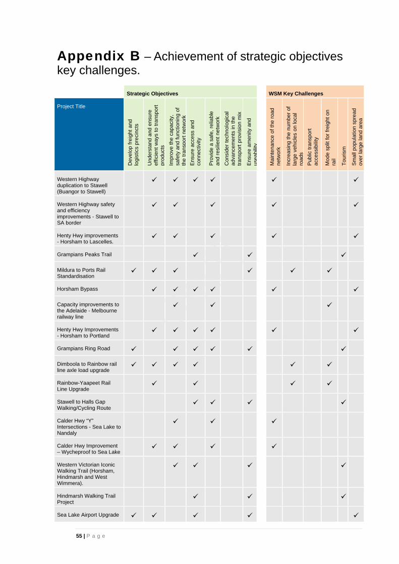
55 | P a g e
Appendix B – Achievement of strategic objectives key challenges.
Strategic Objectives WSM Key Challenges
Project Title
Dev
elop
frei
ght a
nd
log
istic
s p
reci
nct
s
Und
erst
and
and
ens
ure
effic
ient
way
s to
tran
spor
t pr
oduc
ts
Impr
ove
the
cap
acity
, sa
fety
and
func
tioni
ng o
f th
e tr
ansp
ort n
etw
ork
Ens
ure
acce
ss a
nd
conn
ectiv
ity
Pro
vide
a s
afe,
rel
iabl
e an
d re
silie
nt n
etw
ork
Con
side
r te
chno
logi
cal
adva
ncem
ents
in th
e tr
ansp
ort p
rovi
sion
mix
Ens
ure
amen
ity a
nd
usea
bilit
y
Mai
nten
ance
of t
he r
oad
netw
ork
Incr
easi
ng th
e nu
mbe
r of
la
rge
vehi
cles
on
loca
l ro
ads
Pub
lic tr
ansp
ort
acc
ess
ibili
ty
Mod
e sp
lit fo
r fr
eigh
t on
rail
Tou
rism
Sm
all p
opul
atio
n sp
read
ov
er la
rge
land
are
a
Western Highway duplication to Stawell (Buangor to Stawell)
Western Highway safety and efficiency improvements - Stawell to SA border
Henty Hwy improvements - Horsham to Lascelles.
Grampians Peaks Trail
Mildura to Ports Rail Standardisation
Horsham Bypass
Capacity improvements to the Adelaide - Melbourne railway line
Henty Hwy Improvements - Horsham to Portland
Grampians Ring Road
Dimboola to Rainbow rail line axle load upgrade
Rainbow-Yaapeet Rail Line Upgrade
Stawell to Halls Gap Walking/Cycling Route
Calder Hwy “Y” Intersections - Sea Lake to Nandaly
Calder Hwy Improvement – Wycheproof to Sea Lake
Western Victorian Iconic Walking Trail (Horsham, Hindmarsh and West Wimmera).
Hindmarsh Walking Trail Project
Sea Lake Airport Upgrade

56 | P a g e
Strategic Objectives WSM Key Challenges
Project Title
Dev
elop
frei
ght a
nd
log
istic
s p
reci
nct
s
Und
erst
and
and
ens
ure
effic
ient
way
s to
tran
spor
t pr
oduc
ts
Impr
ove
the
cap
acity
, sa
fety
and
func
tioni
ng o
f th
e tr
ansp
ort n
etw
ork
Ens
ure
acce
ss a
nd
conn
ectiv
ity
Pro
vide
a s
afe,
rel
iabl
e an
d re
silie
nt n
etw
ork
Con
side
r te
chno
logi
cal
adva
ncem
ents
in th
e tr
ansp
ort p
rovi
sion
mix
Ens
ure
amen
ity a
nd
usea
bilit
y
Mai
nten
ance
of t
he r
oad
netw
ork
Incr
easi
ng th
e nu
mbe
r of
la
rge
vehi
cles
on
loca
l ro
ads
Pub
lic tr
ansp
ort
acc
ess
ibili
ty
Mod
e sp
lit fo
r fr
eigh
t on
rail
Tou
rism
Sm
all p
opul
atio
n sp
read
ov
er la
rge
land
are
a
Stawell Airport
Passenger Rail Extension (shuttle rail service between Kaniva, Horsham and Ararat)
Dimboola to Rainbow Road
Seven Mile Road
Charam-Wombelano Road Upgrade to 6.2 width, Wimmera Hwy to Goroke-Harrow Road
Edenhope-Coleraine Road and the Wimmera Highway Intersection Improvements
Goroke-Harrow Road Upgrade from Wimmera Highway to Nhill-Harrow Road
Coleraine Edenhope Rd Upgrade, south of Harrow
Harrow Goroke Road and Nhill Harrow Rd Intersection Improvements
Nhill-Harrow Road / Wimmera Highway Intersection Improvements
Nhill-Harrow Road Upgrade from Miga Lake Access Road to Coleraine Edenhope Rd and through Hindmarsh Shire Council to Nhill
Serviceton North Telopea Downs Road / Western Highway Intersection Acceleration Lanes
Kaniva-Edenhope Road Upgrade
Sunraysia Highway Improvements - between Pearses Road to Russell Road
Charlton Borung Road Freight Route
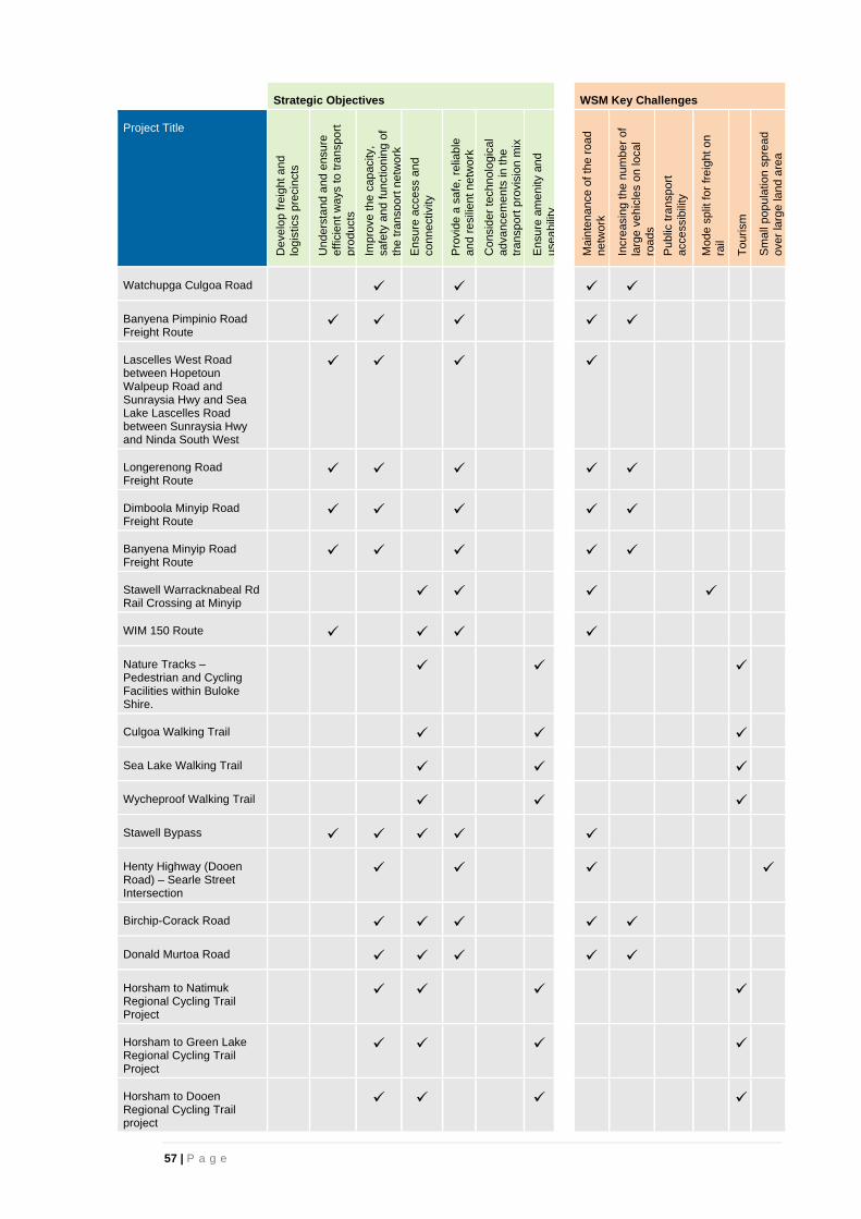
57 | P a g e
Strategic Objectives WSM Key Challenges
Project Title
Dev
elop
frei
ght a
nd
log
istic
s p
reci
nct
s
Und
erst
and
and
ens
ure
effic
ient
way
s to
tran
spor
t pr
oduc
ts
Impr
ove
the
cap
acity
, sa
fety
and
func
tioni
ng o
f th
e tr
ansp
ort n
etw
ork
Ens
ure
acce
ss a
nd
conn
ectiv
ity
Pro
vide
a s
afe,
rel
iabl
e an
d re
silie
nt n
etw
ork
Con
side
r te
chno
logi
cal
adva
ncem
ents
in th
e tr
ansp
ort p
rovi
sion
mix
Ens
ure
amen
ity a
nd
usea
bilit
y
Mai
nten
ance
of t
he r
oad
netw
ork
Incr
easi
ng th
e nu
mbe
r of
la
rge
vehi
cles
on
loca
l ro
ads
Pub
lic tr
ansp
ort
acc
ess
ibili
ty
Mod
e sp
lit fo
r fr
eigh
t on
rail
Tou
rism
Sm
all p
opul
atio
n sp
read
ov
er la
rge
land
are
a
Watchupga Culgoa Road
Banyena Pimpinio Road Freight Route
Lascelles West Road between Hopetoun Walpeup Road and Sunraysia Hwy and Sea Lake Lascelles Road between Sunraysia Hwy and Ninda South West
Longerenong Road Freight Route
Dimboola Minyip Road Freight Route
Banyena Minyip Road Freight Route
Stawell Warracknabeal Rd Rail Crossing at Minyip
WIM 150 Route
Nature Tracks – Pedestrian and Cycling Facilities within Buloke Shire.
Culgoa Walking Trail
Sea Lake Walking Trail
Wycheproof Walking Trail
Stawell Bypass
Henty Highway (Dooen Road) – Searle Street Intersection
Birchip-Corack Road
Donald Murtoa Road
Horsham to Natimuk Regional Cycling Trail Project
Horsham to Green Lake Regional Cycling Trail Project
Horsham to Dooen Regional Cycling Trail project

58 | P a g e
Strategic Objectives WSM Key Challenges
Project Title
Dev
elop
frei
ght a
nd
log
istic
s p
reci
nct
s
Und
erst
and
and
ens
ure
effic
ient
way
s to
tran
spor
t pr
oduc
ts
Impr
ove
the
cap
acity
, sa
fety
and
func
tioni
ng o
f th
e tr
ansp
ort n
etw
ork
Ens
ure
acce
ss a
nd
conn
ectiv
ity
Pro
vide
a s
afe,
rel
iabl
e an
d re
silie
nt n
etw
ork
Con
side
r te
chno
logi
cal
adva
ncem
ents
in th
e tr
ansp
ort p
rovi
sion
mix
Ens
ure
amen
ity a
nd
usea
bilit
y
Mai
nten
ance
of t
he r
oad
netw
ork
Incr
easi
ng th
e nu
mbe
r of
la
rge
vehi
cles
on
loca
l ro
ads
Pub
lic tr
ansp
ort
acc
ess
ibili
ty
Mod
e sp
lit fo
r fr
eigh
t on
rail
Tou
rism
Sm
all p
opul
atio
n sp
read
ov
er la
rge
land
are
a
Sunraysia Highway Improvements north of Curyo and southeast of Donald
Mildura Passenger Service
Borung Highway
Western Highway duplication to the SA border
Warracknabeal Birchip Road
Hopetoun Airport Upgrade (Airports)
Birchip - Sea Lake Road
Horsham bridges – Wimmera River crossing, road and pedestrian / bicycle
Stawell Warracknabeal Road
Horsham Kalkee Road
Rainbow Airstrip Upgrade
Horsham Drung South Road
Nhill-Yanac Road
Warracknabeal Airport Upgrade
Murtoa-Glenorchy Road
Regional GIS Capability
O’Callaghans Parade – 45 Degree Y Intersections
Donald Airport Upgrade
Nhill Airport Runway Extension
Stawell Road U-Turn

59 | P a g e
Strategic Objectives WSM Key Challenges
Project Title
Dev
elop
frei
ght a
nd
log
istic
s p
reci
nct
s
Und
erst
and
and
ens
ure
effic
ient
way
s to
tran
spor
t pr
oduc
ts
Impr
ove
the
cap
acity
, sa
fety
and
func
tioni
ng o
f th
e tr
ansp
ort n
etw
ork
Ens
ure
acce
ss a
nd
conn
ectiv
ity
Pro
vide
a s
afe,
rel
iabl
e an
d re
silie
nt n
etw
ork
Con
side
r te
chno
logi
cal
adva
ncem
ents
in th
e tr
ansp
ort p
rovi
sion
mix
Ens
ure
amen
ity a
nd
usea
bilit
y
Mai
nten
ance
of t
he r
oad
netw
ork
Incr
easi
ng th
e nu
mbe
r of
la
rge
vehi
cles
on
loca
l ro
ads
Pub
lic tr
ansp
ort
acc
ess
ibili
ty
Mod
e sp
lit fo
r fr
eigh
t on
rail
Tou
rism
Sm
all p
opul
atio
n sp
read
ov
er la
rge
land
are
a
Wimmera Highway (Natimuk Road) – Bennett Road Intersection
Grampians Road
Horsham Railway Bypass
Horsham Airport Redevelopment
Horsham Railway Pedestrian Underpasses
Natimuk Hamilton Road
Donald-Stawell Road
Horsham - Minyip Road
Changes to grain freight transport on road.
Patchewollock Sea Lake Road
May Park Rest Area (Horsham)
Level Crossing Removal with Northern Grampians Shire
Patchewollock Airport Upgrade
Horsham Noradjuha Road

60 | P a g e
Appendix C – Airport details
Airport requirements with Wimmera Southern Mallee Region
Airport Current Capability and Key Issues Desired Capability and Solutions
Horsham The Horsham airport has a sealed runway
with lighting and is used for a variety of
activities which include:
>400 Air ambulance transfers per
year.
Pilot training.
DEPI Airbase.
Aircraft maintenance.
Gliding activity – premium location.
A key issue is the potential for the
Horsham Bypass alignment to impact on
possible runway extension.
Horsham airport has been identified
as having the potential to increase
utilisation commercial operations and
as a commute option to Melbourne.
These uses are likely to require
increased runway length. Additionally
land around the airport should be
complementary to the airport to
provide for efficient commercial
operations.
Stawell The Stawell airport has a sealed main
runway and taxiway with a night lights,
terminal building and fuel facility.
Additionally there is a sealed second
runway and two taxiways.
Stawell Aviation Services-Tecman
aircraft sales Australia wide, joy
flights locally, Australia wide tours
and charter flights, pilot training.
AG Services-Fire bombers,
agricultural & forestry sprayers,
aircraft maintenance, charter flights,
FIFO services.
Major DEPI fire base for western
Victoria.
A number of upgrades have been
identified for Stawell airport to
improve the efficiency of the facility
and allow for future growth, these
include:
Apron extensions for future
developments.
Security / vermin fencing.
Small car park and additional
airside road access,
undergrounding of power line.
Upgrade of existing DEPI
firebase including additional
taxiway and helicopter parking
area upgrades.
St Arnaud The St Arnaud airport has a sealed runway
and taxiway and is used for the following
key activities:
Small DEPI fire base facility for
regional CFA aircraft.
Emergency pilot activated solar
lighting.
District aerial agricultural spraying.
Upgrades are required to enable
the facility to be operational in all
weather conditions and meet the
current CASA requirements.
Improvements include:
Surface treatment and
widening of main runway and
taxiway.
Line marking and associated
road access and apron
upgrade works.

61 | P a g e
Airport Current Capability and Key Issues Desired Capability and Solutions
Nhill The Nhill airport has a sealed runway
however it is too short to allow for small to
medium jet aircraft to land at Nhill. This
restricts the type of aircraft and also the
business interests in Hindmarsh due to
reduced accessibility.
Increase the length of the sealed (27)
runway by 175m to allow an
increased and broader range of
aircraft to have the ability to land at
Nhill.
This increases the accessibility of
Hindmarsh and allows for Nhill to be
used as a base of aerial fire fighting
activity.
Sea Lake Recent inspections have identified the
following deficiencies:
Urgent maintenance is required on
the movement areas including: weed
removal, pavement repairs and
surface improvements on the main
Runway.
Unserviceability crosses are required
to properly prepare for a runway
closure.
The need for a windsock.
Sea Lake airport needs the surface
to be upgraded and widened to
improve safety and cater for general
aviation activities and also provide
necessary facilities for emergency
services aircraft.
The improvements will allow:
Sea Lake Airport to have
greater utilisation from
agricultural spraying business.
Improved emergency service
facilities.
Donald The Donald airport has a sealed strip and a
grass strip. Due to the weather conditions it
is not an all-weather facility.
The airport provides services for local
agriculture and businesses, commercial
aircraft, air ambulance services and
recreational light aircraft.
Donald has a strong commercial centre
with a growing industrial estate. The
business and industrial sector currently use
the local airport for passenger movement
and the quick transport of freight and
emergency parts.
The airport currently does not have fire
fighting capacity.
The airport needs to be upgraded to
become an all-weather facility. This
includes:
Seal the north-south runway.
Upgrade power supply to meet
CASA requirements.
Improve passenger and pilot
amenities (terminal).
Install an open top water tank
available for fire fighting
purposes.

62 | P a g e
Airport Current Capability and Key Issues Desired Capability and Solutions
Hopetoun The Hopetoun Airport is one of two airports
in Yarriambiack and services the relatively
isolated but third largest township in the
municipality, Hopetoun. The Hopetoun
airport is the closest airport to Wyperfeld
National Park.
The airport has been identified to be
upgraded to meet the CASA Design
Standards for Licenced Airports for all
weather traffic and ensure long-term
sustainability of the Hopetoun Airport.
The Hopetoun airport needs to be
upgraded to provide two sealed
runways, to provide for all weather
air traffic. This will improve safety
and cater for general aviation
activities and some charter
operations. It will also provide
necessary facilities for emergency
services aircraft, particularly the air
ambulance, and for agricultural
purposes. It will also enable the
airport to be used for fire fighting is
required.
Patchewollock Patchewollock Airport is currently an
unregistered airport that services the small
isolated township of Patchewollock and the
northern part of the Shire of Yarriambiack.
The airport is close to Wyperfeld National
Park.
The airport has been identified to be
upgraded to meet the CASA Design
Standards to ensure long-term
sustainability and improve safety.
The Patchewollock airport needs to
be upgraded to improve safety and
cater for general aviation activities. It
will also provide necessary facilities
for emergency services aircraft,
particularly the air ambulance and for
agricultural purposes.
Warracknabeal The Warracknabeal airport is a registered
airport in Yarriambiack and services the
largest township in the municipality.
The airport has been identified to be
upgraded to meet the CASA Design
Standards for Licenced Airports for all
weather traffic and ensure long-term
sustainability of the Warracknabeal Airport.
The Warracknabeal airport needs to
be upgraded to provide two sealed
runways, to provide for all weather
air traffic. This will improve safety
and cater for general aviation
activities and some charter
operations.
It will also provide necessary facilities
for emergency services aircraft, fly in
specialist medical services and for
agricultural purposes.
Kaniva No information provided
Edenhope No information provided
Birchip No information provided
Charlton No information provided
Wycheproof No information provided