win-pst 3 - home | nrcs€¦ · win-pst is an environmental risk screening tool for pesticides....
TRANSCRIPT

WIN-PST 3.1 User Help
WIN-PST 3.1 User Help


Table Of Contents WIN-PST 3.1 User Help............................................................................................................................................... 1
Introduction............................................................................................................................................................ 1 Getting Started ....................................................................................................................................................... 1 About the Windows Pesticide Screening Tool (WIN-PST).................................................................................... 1 Contact Us ............................................................................................................................................................... 2
For WIN-PST technical support issues contact: ......................................................................................... 2 For WIN-PST policy issues contact: ............................................................................................................ 2
Other Resources ..................................................................................................................................................... 3 Disclaimer................................................................................................................................................................ 4 Uninstall WIN-PST .................................................................................................................................................. 4
The Desktop......................................................................................................................................................... 5 Starting WIN-PST 3.1............................................................................................................................................. 5
The Menus............................................................................................................................................................ 6 The Buttons ......................................................................................................................................................... 6 The Databases ..................................................................................................................................................... 6
Customizing Your Desktop ..................................................................................................................................... 7 Soils Tab .................................................................................................................................................................. 7
User Input Columns ............................................................................................................................................ 7 Soils Tab Controls ............................................................................................................................................... 8
AIs (Active Ingredients) Tab.................................................................................................................................. 9 User Input Columns ............................................................................................................................................ 9 AIs Tab Controls ................................................................................................................................................ 10
Products Tab ......................................................................................................................................................... 12 User Input Columns .......................................................................................................................................... 12 Products Tab Controls ....................................................................................................................................... 13
Scenarios Tab ....................................................................................................................................................... 14 Activities............................................................................................................................................................. 14 Overview ............................................................................................................................................................ 14 Saving a new Scenario...................................................................................................................................... 15 Editing a Scenario ............................................................................................................................................. 16 Deleting a Scenario ........................................................................................................................................... 16
Interactions Tab.................................................................................................................................................... 19 Data Grid Columns ............................................................................................................................................... 20
Data Management ............................................................................................................................................. 26 Data Management - Introduction ........................................................................................................................ 26
iii
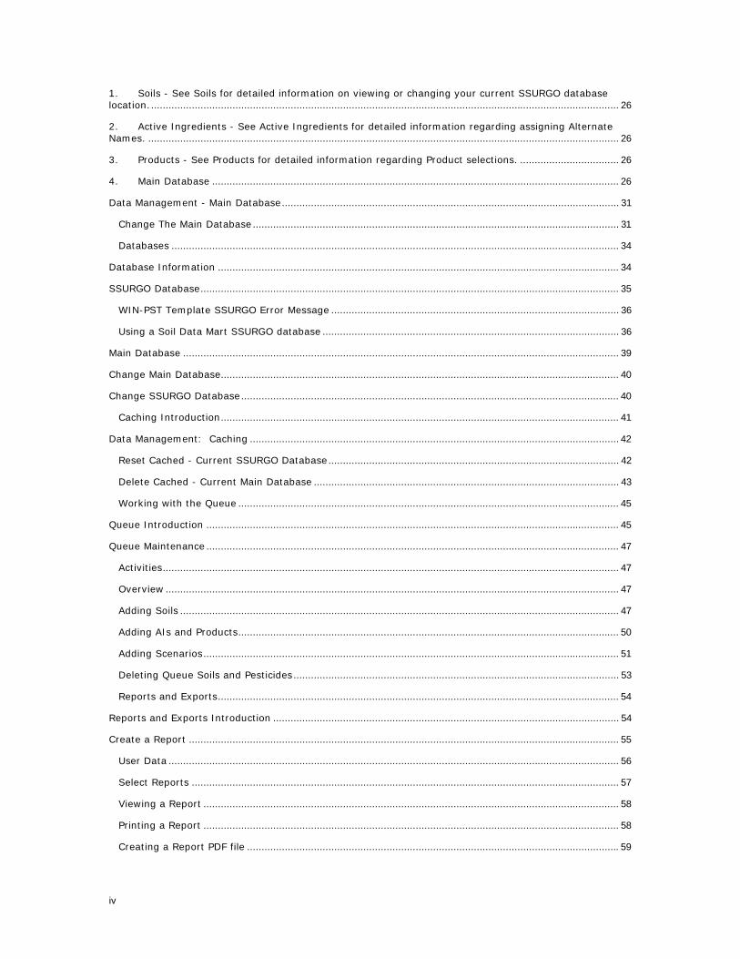
1. Soils - See Soils for detailed information on viewing or changing your current SSURGO database location.................................................................................................................................................................. 26 2. Active Ingredients - See Active Ingredients for detailed information regarding assigning Alternate Names. .................................................................................................................................................................. 26 3. Products - See Products for detailed information regarding Product selections. .................................. 26 4. Main Database ............................................................................................................................................ 26 Data Management - Main Database.................................................................................................................... 31
Change The Main Database .............................................................................................................................. 31 Databases .......................................................................................................................................................... 34
Database Information .......................................................................................................................................... 34 SSURGO Database................................................................................................................................................ 35
WIN-PST Template SSURGO Error Message ................................................................................................... 36 Using a Soil Data Mart SSURGO database ...................................................................................................... 36
Main Database ...................................................................................................................................................... 39 Change Main Database......................................................................................................................................... 40 Change SSURGO Database .................................................................................................................................. 40
Caching Introduction......................................................................................................................................... 41 Data Management: Caching ............................................................................................................................... 42
Reset Cached - Current SSURGO Database .................................................................................................... 42 Delete Cached - Current Main Database ......................................................................................................... 43 Working with the Queue ................................................................................................................................... 45
Queue Introduction .............................................................................................................................................. 45 Queue Maintenance .............................................................................................................................................. 47
Activities............................................................................................................................................................. 47 Overview ............................................................................................................................................................ 47 Adding Soils ....................................................................................................................................................... 47 Adding AIs and Products................................................................................................................................... 50 Adding Scenarios............................................................................................................................................... 51 Deleting Queue Soils and Pesticides ................................................................................................................ 53 Reports and Exports.......................................................................................................................................... 54
Reports and Exports Introduction ....................................................................................................................... 54 Create a Report .................................................................................................................................................... 55
User Data ........................................................................................................................................................... 56 Select Reports ................................................................................................................................................... 57 Viewing a Report ............................................................................................................................................... 58 Printing a Report ............................................................................................................................................... 58 Creating a Report PDF file ................................................................................................................................ 59
iv
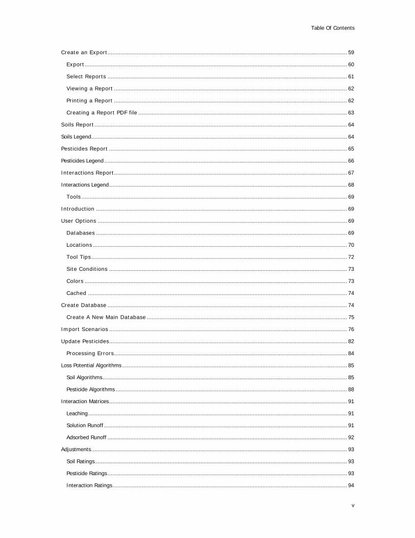
Table Of Contents
Create an Export................................................................................................................................................... 59 Export................................................................................................................................................................. 60 Select Reports ................................................................................................................................................... 61 Viewing a Report ............................................................................................................................................... 62 Printing a Report ............................................................................................................................................... 62 Creating a Report PDF file ................................................................................................................................ 63
Soils Report ........................................................................................................................................................... 64 Soils Legend............................................................................................................................................................. 64 Pesticides Report .................................................................................................................................................. 65 Pesticides Legend..................................................................................................................................................... 66 Interactions Report............................................................................................................................................... 67 Interactions Legend.................................................................................................................................................. 68
Tools ................................................................................................................................................................... 69 Introduction .......................................................................................................................................................... 69 User Options ......................................................................................................................................................... 69
Databases .......................................................................................................................................................... 69 Locations ............................................................................................................................................................ 70 Tool Tips............................................................................................................................................................. 72 Site Conditions .................................................................................................................................................. 73 Colors ................................................................................................................................................................. 73 Cached ............................................................................................................................................................... 74
Create Database ................................................................................................................................................... 74 Create A New Main Database ........................................................................................................................... 75
Import Scenarios .................................................................................................................................................. 76 Update Pesticides.................................................................................................................................................. 82
Processing Errors............................................................................................................................................... 84 Loss Potential Algorithms .......................................................................................................................................... 85
Soil Algorithms...................................................................................................................................................... 85 Pesticide Algorithms .............................................................................................................................................. 88
Interaction Matrices.................................................................................................................................................. 91 Leaching............................................................................................................................................................... 91 Solution Runoff ..................................................................................................................................................... 91 Adsorbed Runoff ................................................................................................................................................... 92
Adjustments............................................................................................................................................................. 93 Soil Ratings........................................................................................................................................................... 93 Pesticide Ratings ................................................................................................................................................... 93 Interaction Ratings................................................................................................................................................ 94
v
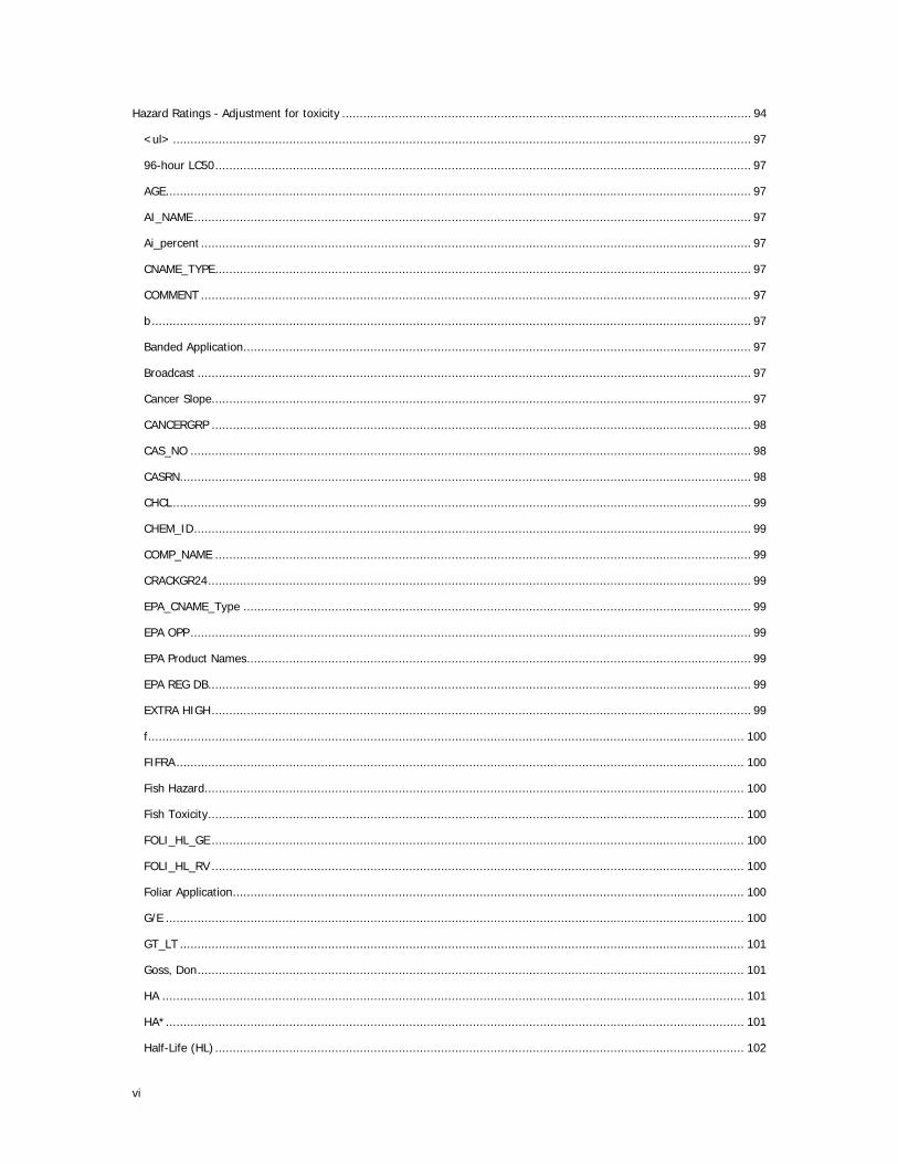
Hazard Ratings - Adjustment for toxicity .................................................................................................................... 94 <ul> .................................................................................................................................................................... 97 96-hour LC50........................................................................................................................................................ 97 AGE...................................................................................................................................................................... 97 AI_NAME.............................................................................................................................................................. 97 Ai_percent ............................................................................................................................................................ 97 CNAME_TYPE........................................................................................................................................................ 97 COMMENT ............................................................................................................................................................ 97 b.......................................................................................................................................................................... 97 Banded Application................................................................................................................................................ 97 Broadcast ............................................................................................................................................................. 97 Cancer Slope......................................................................................................................................................... 97 CANCERGRP ......................................................................................................................................................... 98 CAS_NO ............................................................................................................................................................... 98 CASRN.................................................................................................................................................................. 98 CHCL.................................................................................................................................................................... 99 CHEM_ID.............................................................................................................................................................. 99 COMP_NAME ........................................................................................................................................................ 99 CRACKGR24.......................................................................................................................................................... 99 EPA_CNAME_Type ................................................................................................................................................ 99 EPA OPP............................................................................................................................................................... 99 EPA Product Names............................................................................................................................................... 99 EPA REG DB.......................................................................................................................................................... 99 EXTRA HIGH......................................................................................................................................................... 99 f......................................................................................................................................................................... 100 FIFRA................................................................................................................................................................. 100 Fish Hazard......................................................................................................................................................... 100 Fish Toxicity........................................................................................................................................................ 100 FOLI_HL_GE ....................................................................................................................................................... 100 FOLI_HL_RV ....................................................................................................................................................... 100 Foliar Application................................................................................................................................................. 100 G/E .................................................................................................................................................................... 100 GT_LT ................................................................................................................................................................ 101 Goss, Don........................................................................................................................................................... 101 HA ..................................................................................................................................................................... 101 HA*.................................................................................................................................................................... 101 Half-Life (HL) ...................................................................................................................................................... 102
vi

Table Of Contents
Hazard ............................................................................................................................................................... 102 HIGH.................................................................................................................................................................. 102 High Water Table ................................................................................................................................................ 102 Human Hazard.................................................................................................................................................... 102 Human Toxicity ................................................................................................................................................... 102 HWT_LT_24........................................................................................................................................................ 102 HWT .................................................................................................................................................................. 102 i ......................................................................................................................................................................... 102 I-Ratings ............................................................................................................................................................ 103 IARP................................................................................................................................................................... 103 ILP ..................................................................................................................................................................... 103 IMPORTDATE...................................................................................................................................................... 103 INTERMEDIATE................................................................................................................................................... 103 ISRP................................................................................................................................................................... 103 Kd...................................................................................................................................................................... 103 KFACT ................................................................................................................................................................ 104 Koc .................................................................................................................................................................... 104 KOC_GE ............................................................................................................................................................. 104 KOC_RV ............................................................................................................................................................. 104 l ......................................................................................................................................................................... 104 LC50 .................................................................................................................................................................. 104 LOC.................................................................................................................................................................... 105 Loss Potential ..................................................................................................................................................... 105 LOW................................................................................................................................................................... 105 Low Rate ............................................................................................................................................................ 105 m....................................................................................................................................................................... 105 Macropores......................................................................................................................................................... 105 MATC* ............................................................................................................................................................... 105 MCL ................................................................................................................................................................... 106 MUSYM............................................................................................................................................................... 106 n........................................................................................................................................................................ 106 NAME ................................................................................................................................................................. 106 NAPRA................................................................................................................................................................ 106 NAPRA PPD......................................................................................................................................................... 106 NPURG ............................................................................................................................................................... 106 OMH / OM_H ...................................................................................................................................................... 106 OML / OM_L ....................................................................................................................................................... 106
vii

OPPRFD.............................................................................................................................................................. 106 OW .................................................................................................................................................................... 106 OWRFD .............................................................................................................................................................. 107 P-Ratings............................................................................................................................................................ 107 PARP .................................................................................................................................................................. 107 PC_CODE............................................................................................................................................................ 107 PCT_WASHOF..................................................................................................................................................... 107 pH...................................................................................................................................................................... 107 PHH ................................................................................................................................................................... 107 PHL .................................................................................................................................................................... 107 PKA.................................................................................................................................................................... 107 PKB .................................................................................................................................................................... 107 PLP .................................................................................................................................................................... 107 PSRP .................................................................................................................................................................. 107 QSTAR ............................................................................................................................................................... 108 RFD.................................................................................................................................................................... 108 ROCKDEPH ......................................................................................................................................................... 108 ROCKDEPL.......................................................................................................................................................... 108 s ........................................................................................................................................................................ 108 S-Ratings............................................................................................................................................................ 108 SARP.................................................................................................................................................................. 108 SHRINKSW ......................................................................................................................................................... 108 Slope.................................................................................................................................................................. 108 SLOPE_H ............................................................................................................................................................ 108 SLOPEGR15 ........................................................................................................................................................ 108 SLP .................................................................................................................................................................... 108 SOIL_HL_GE....................................................................................................................................................... 108 SOIL_HL_RV ....................................................................................................................................................... 109 Soil Incorporated ................................................................................................................................................ 109 SOL_GE.............................................................................................................................................................. 109 SOL_RV.............................................................................................................................................................. 109 Solubility (SOL) ................................................................................................................................................... 109 SOURCE ............................................................................................................................................................. 109 SPISP II.............................................................................................................................................................. 109 SPISP II Ratings.................................................................................................................................................. 109 SSRP .................................................................................................................................................................. 109 Standard Rate..................................................................................................................................................... 109
viii

Table Of Contents
STSSAID............................................................................................................................................................. 110 STUDY_CAS........................................................................................................................................................ 110 STUDY_NAME ..................................................................................................................................................... 110 STUDY_PC.......................................................................................................................................................... 110 Study_time ......................................................................................................................................................... 110 STV.................................................................................................................................................................... 110 Surface Applied................................................................................................................................................... 110 SURFACE DEPTH................................................................................................................................................. 110 TAXA.................................................................................................................................................................. 110 TAXONOMIC ....................................................................................................................................................... 110 TEXTURE............................................................................................................................................................ 111 TOX_PPB ............................................................................................................................................................ 111 TOX_TIME .......................................................................................................................................................... 111 TOX_TYPE .......................................................................................................................................................... 111 Ultra Low Rate .................................................................................................................................................... 112 USEPARFD.......................................................................................................................................................... 112 Usepattern.......................................................................................................................................................... 112 USER_OM........................................................................................................................................................... 112 VERY LOW.......................................................................................................................................................... 112 VP_GE ................................................................................................................................................................ 112 VP_MMHG .......................................................................................................................................................... 112 VP_PH ................................................................................................................................................................ 112 w ....................................................................................................................................................................... 112 WHO .................................................................................................................................................................. 112 WHORFD ............................................................................................................................................................ 112 WIN-PST PPD ..................................................................................................................................................... 112 WTDEPL ............................................................................................................................................................. 112 WTKIND ............................................................................................................................................................. 113 USER_DEPTH...................................................................................................................................................... 113
ix

WIN-PST 3.1 User Help
Windows Pesticide Screening Tool Version 3.1
Introduction
Getting Started
The Windows Pesticide Screening Tool (WIN-PST) User Guide describes how to use the WIN-PST application. For information about installing WIN-PST, see the Installation section in this user guide.
To learn more about using WIN-PST 3.1, see Starting WIN-PST.
If you have questions that are not answered in this user help, please Contact us!
About the Windows Pesticide Screening Tool (WIN-PST)
The USDA NRCS West National Technology Support Center, Water Quality and Quantity National Technology Development Team, developed and supports the Windows Pesticide Screening Tool (WIN-PST). NRCS Pest Management Policy (November 2001) requires the use of WIN-PST or other NRCS-approved environmental risk analysis tools in supporting the development of the pest management component of a conservation plan.
WIN-PST is an environmental risk screening tool for pesticides. NRCS field office conservationists, extension agents, crop consultants, pesticide dealers and producers can use it to evaluate the potential of pesticides to move with water and eroded soil/organic matter and affect non-targeted organisms.
NRCS partners (such as private pest control advisors) now have access to this easy-to-use science-based tool for considering environmental risk and making recommendations. WIN-PST goes beyond previous NRCS screening tools in
1

WIN-PST 3.1 User Help
considering the impact of water table depth, rainfall probability, pesticide application area, application method and rate class (Standard, Low, Ultralow).
WIN-PST users can specify pesticides by product name or active ingredient. Long-term human and fish toxicity data and ratings are also included in WIN-PST. These toxicity ratings can be combined with the off-site movement potential ratings to provide an overall rating of the potential risks from pesticide movement below the root zone and past the edge of the field.
WIN-PST is based on algorithms contained in:
Goss, D., and R. D. Wauchope (1990). The SCS/ARS/CES Pesticide Properties Database II: Using it with soils data in a screening procedure. In: Proceedings of the Third National Research Conference on Pesticides. Nov. 8-9, 1990 Richmond Virginia. Weigmann D. L. editor.
The United States Department of Agriculture (USDA) prohibits discrimination in its programs on the basis of race, color, national origin, sex, religion, age, disability, political beliefs and marital or familial status. (Not all prohibited bases apply to all programs.) Persons with disabilities who require alternative means for communication of program information (Braille, large print, audio tape, etc.) should contact the USDA Office of Communications at (202) 720-2791.
Contact Us
For WIN-PST technical support issues contact:
Eric S.Hesketh
mailto:[email protected]
(413)253-4374
VoiceCom: 9047-4374
451 West Street
Amherst, MA 01002
For WIN-PST policy issues contact:
Joseph K.Bagdon
mailto:[email protected]
(413) 253-4376
VoiceCom: 9047-4376
451 West Street
Amherst, MA 01002
2
WIN-PST User Help
Other Resources
Welcome to the Windows Pesticide Screening Tool (WIN-PST).
The following section provides links and references to additional resources.
Current WIN-PST Page:
http://www.wsi.nrcs.usda.gov/products/W2Q/pest/winpst.html
NRCS
http://www.nrcs.usda.gov/
National Technology Support Centers
East
http://www.nrcs.usda.gov/about/ntsc/east/index.html
Central
http://www.nrcs.usda.gov/about/ntsc/central/index.html
West
http://www.nrcs.usda.gov/about/ntsc/west/index.html
NRCS Pest Management
http://www.wsi.nrcs.usda.gov/products/W2Q/pest/pest_mgt.html
http://www.nrcs.usda.gov/technical/nutrient.html
Integrated Pest Management (IPM)
http://www.ipmcenters.org/index.cfm
http://www.ipminstitute.org/
http://northeastipm.org/nrcs.cfm
http://www.ipm.msu.edu/work-group/how-to.htm
http://www.ipm.msu.edu/work-group/aboutUs.htm
http://www.ipm.ucdavis.edu/
Labels and MSDS
http://www.cdms.net/LabelsMsds/LMDefault.aspx
http://greenbook.net/
3

WIN-PST 3.1 User Help
Disclaimer
In accordance with USDA Natural Resources Conservation Service (NRCS) Pest Management Policy (http://policy.nrcs.usda.gov/viewerFS.aspx?id=213), the Windows Pesticide Screening Tool (WIN-PST 3.1) is designed to provide information that is needed to develop the Pest Management Component of an NRCS Conservation Plan.
Other use of WIN-PST 3.1 information may be out of context and inappropriate.
Please contact a member of the USDA-NRCS West National Technology Support Center, Water Quality and Quantity Team: Contact us! or your local NRCS representative (http://www.nrcs.usda.gov) for more information.
Uninstall WIN-PST
When you uninstall WIN-PST 3.1, the software application and installed data and Help files are deleted. After the uninstall, be sure to remove any unwanted files and folders that were created during the use of WIN-PST 3.1.
To remove WIN-PST 3.1 from your system, select Start>Control Panel>Add or Remove Programs:
Locate Windows Pesticide Screening Tool 3.1 on the Add or Remove Programs screen. Click the Remove button to remove this program from your computer.
4

WIN-PST User Help
The Desktop
Starting WIN-PST 3.1
The Desktop is the first screen you see when you run WIN-PST. All functions and features are available from the WIN-PST Desktop.
Note: The first time you start WIN-PST 3.1 you will be asked to identify a SSURGO Database to use. A Sample SSURGO database is provided with the installation. The following example screen will display:
Click Yes to start with the Sample SSURGO database. Click No to proceed to Data Management and locate another SSURGO database.
To start WIN-PST, select Start>All Programs>Engineering Applications>WIN-PST 3.1>Start WIN-PST 3.1:
5

WIN-PST 3.1 User Help
The WIN-PST 3.1 Desktop will display:
Since you can customize your Desktop, your screen may not appear exactly like the one above.
The Menus
A variety of pull-down menus are listed along the top of the Desktop. The menus list the WIN-PST commands. The menus and commands are discussed in this manual when needed for a particular procedure.
The Buttons
In the Desktop screen shown above, several buttons are displayed for your view. If any of these buttons are grayed instead of bold, those buttons are not available for use at the current time.
The Databases
WIN-PST 3.1 requires two Access database files. The installation of WIN-PST 3.1 installs a default Main database and a sample SSURGO database. Using WIN-PST, you can create additional Main database files and also attach to other SSURGO database files.
1. The Main database contains all of the Pesticides, Active Ingredients and Products data, and additional WIN-PST related information. The default Main database name is 'winpst31.mdb'. For more information, see Main Database.
2. The sample SSURGO database contains Soils data. The default SSURGO database name is 'SSURGO.mdb'. For more information, see SSURGO Database.
For more information about the WIN-PST databases you are using, see Database Information.
6

WIN-PST User Help
Customizing Your Desktop
Certain features on the WIN-PST Desktop are customizable. For more information, see User Options in the Tools chapter.
Soils Tab
On the Select Soils and Pesticides screen, choose the Soils tab to see the Soils grid on the WIN-PST Desktop. The following example screen will display:
See Data Grid Columns for additional information about the Soils grid.
See Queue Introduction for additional information about adding Soils to the Queue.
User Input Columns
The following columns allow user input in the Soils grid:
USER_OM - Percent organic matter in the first soil horizon.
USER_DEPTH - The Depth (inches) of the soil surface horizon.
SLOPEGR15 - Check if field slope greater than 15%.
CRACKSGR24 - Check if there are surface connected macropores (cracks) that go at least 24 inches deep.
HWT_LT_24 - Check if High Water Table less than 24" under the surface.
7

WIN-PST 3.1 User Help
Soils Tab Controls
The Survey Area: selection allows you to pick from a list of Soil Survey Areas associated with a SSURGO database. When you connect to a SURRGO database, you can select some or all of the Soil Survey Areas. For more information, see Data Management. The Soils data grid, as shown in the example above, contains Soils information for Hampshire Counties, Massachusetts, Eastern Part: MA610.
The Soils data grid can show or hide additional information based on the checkbox settings for:
Ratings checkbox - when checked, will show columns for:
SLP SSRP SARP
Properties checkbox - when checked, will show columns for:
HYDRO KFACT USER_OM USER_DEPTH
Management checkbox - when checked, will show columns for:
CRACKSGR24 SLOPEGR15 HWT_LT_24
Exclude allows you to enter a PCT_COMP numeric percentage value to filter the rows of information shown in the Soils grid. As an example, enter 10 to hide all rows that have a PCT_COMP value of 10 or less.
Locate Records Where will search for Soils Grid rows.
1. Pick a column name from the list to be used for the searched column values.
2. Select the Contains radio button to find all rows containing the value you are looking for, or select the Begins With radio button to find all rows that start with the value you are looking for.
3. In the right-side text box, enter the value you are looking for.
Note: Using the Locate Records selection process will immediately adjust the number of Soils grid rows displayed.
8

WIN-PST User Help
AIs (Active Ingredients) Tab
On the Select Soils and Pesticides screen, choose the AIs tab to see the Active Ingredients grid on the WIN-PST Desktop. The following example screen will display:
See Data Grid Columns for additional information about the Active Ingredients grid.
See Queue Introduction for additional information about adding Active Ingredients to the Queue.
User Input Columns
The following columns allow user input on the Active Ingredients grid:
APP_AREA - Broadcast application (default) - applied to more than 1/2 of the field; Banded application - applied to 1/2 of the field or less; Spot application - applied to 1/10th of the field or less.
APP_METH - Surface applied (default) - applied to the soil surface; Soil incorporated - with light tillage or irrigation; Foliar application - directed spray at nearly full crop/weed canopy.
APP_RATE - Standard rate (default) - a label rate greater than 1/4 lb active ingredient per acre (280 g/ha); Low rate - a rate of 1/10 to 1/4 lb active ingredient per acre (112 to 280 grams per hectare); Ultra low
9
WIN-PST 3.1 User Help
rate - a rate of 1/10 lb or less active ingredient per acre (112 grams per hectare).
AIs Tab Controls
Locate Records Where will search for AIs Grid rows.
1. Pick a column name from the list to be used for the searched column values.
2. Select the Contains radio button to find all rows containing the value you are looking for, or select the Begins With radio button to find all rows that start with the value you are looking for. Select the Search Alternate Names checkbox to locate Active Ingredients by Alternate Names. Search Alternate Names is limited to finding Alternate Names using the Contains search.
3. In the right-side text box, enter the value you are looking for.
Note: Using the Locate Records selection process will immediately adjust the number of AIs grid rows displayed.
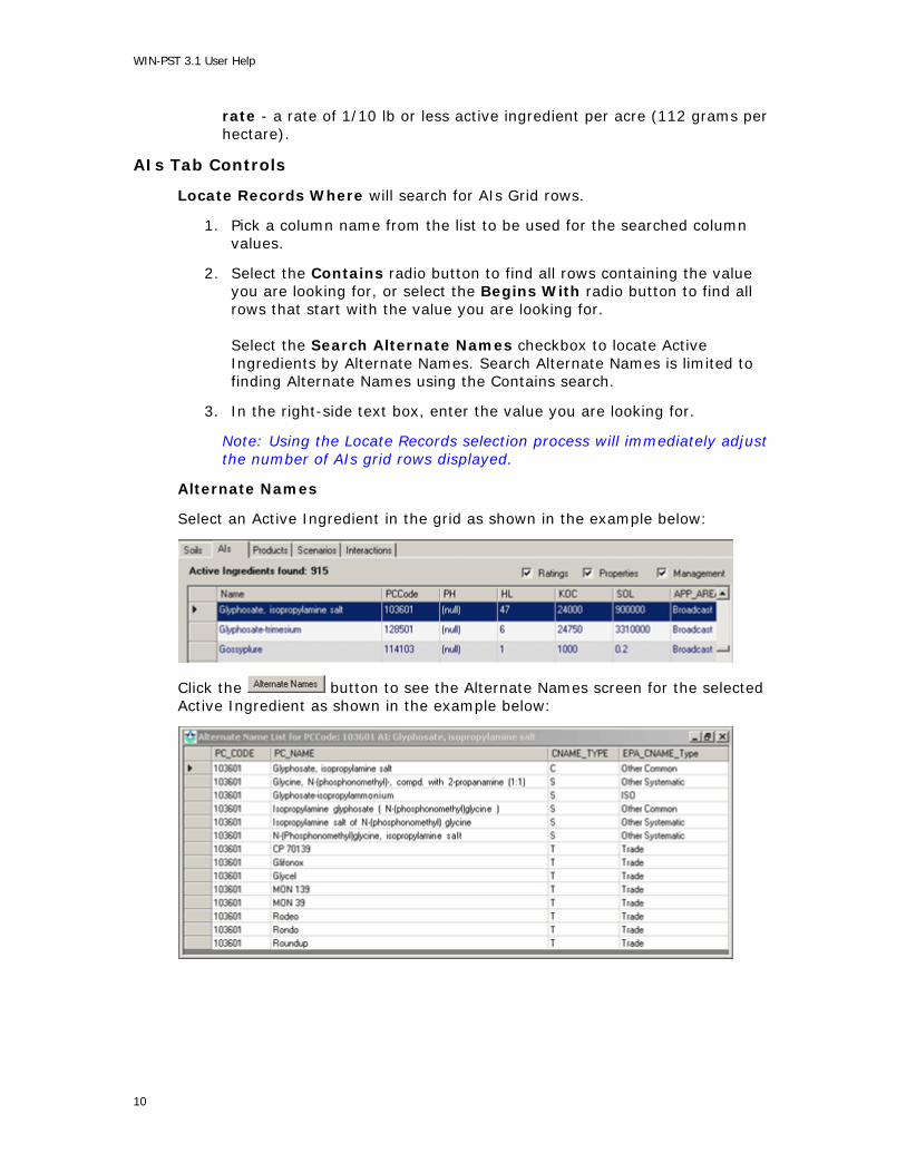
Alternate Names
Select an Active Ingredient in the grid as shown in the example below:
Click the button to see the Alternate Names screen for the selected Active Ingredient as shown in the example below:
10
WIN-PST User Help
List Products
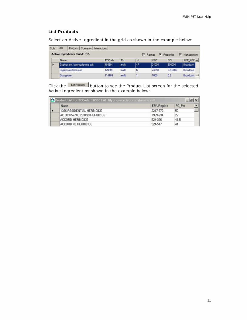
Select an Active Ingredient in the grid as shown in the example below:
Click the button to see the Product List screen for the selected Active Ingredient as shown in the example below:
11

WIN-PST 3.1 User Help
Products Tab
On the Select Soils and Pesticides screen, choose the Products tab to see the Products grid on the WIN-PST Desktop. The following example screen will display:
See Data Grid Columns for additional information about the Products grid.
See Queue Introduction for additional information about adding Products to the Queue.
User Input Columns
The following columns allow user input on the Products grid:
APP_AREA - Broadcast application (default) - applied to more than 1/2 of the field; Banded application - applied to 1/2 of the field or less; Spot application - applied to 1/10th of the field or less.
APP_METH - Surface applied (default) - applied to the soil surface; Soil incorporated - with light tillage or irrigation; Foliar application - directed spray at nearly full crop/weed canopy.
APP_RATE - Standard rate (default) - a label rate greater than 1/4 lb active ingredient per acre (280 g/ha); Low rate - a rate of 1/10 to 1/4 lb active ingredient per acre (112 to 280 grams per hectare); Ultra low rate - a rate of 1/10 lb or less active ingredient per acre (112 grams per hectare).
12
WIN-PST User Help
Products Tab Controls
Locate Records Where will search for AIs Grid rows.
1. Pick a column name from the list to be used for the searched column values.
2. Select the Contains radio button to find all rows containing the value you are looking for, or select the Begins With radio button to find all rows that start with the value you are looking for.
3. In the right-side text box, enter the value you are looking for.
Note: Using the Locate Records selection process will immediately adjust the number of Products grid rows displayed.
List Active Ingredients
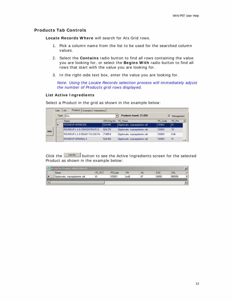
Select a Product in the grid as shown in the example below:
Click the button to see the Active Ingredients screen for the selected Product as shown in the example below:
13
WIN-PST 3.1 User Help
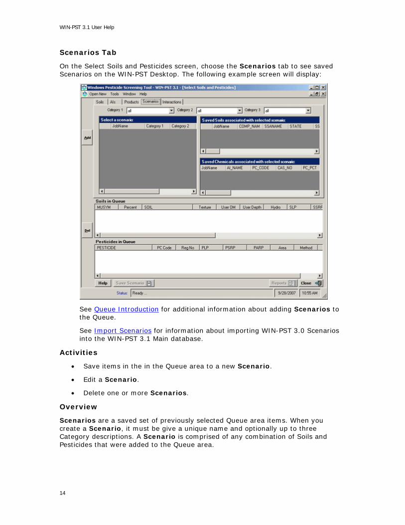
Scenarios Tab
On the Select Soils and Pesticides screen, choose the Scenarios tab to see saved Scenarios on the WIN-PST Desktop. The following example screen will display:
See Queue Introduction for additional information about adding Scenarios to the Queue.
See Import Scenarios for information about importing WIN-PST 3.0 Scenarios into the WIN-PST 3.1 Main database.
Activities
• Save items in the in the Queue area to a new Scenario.
• Edit a Scenario.
• Delete one or more Scenarios.
Overview
Scenarios are a saved set of previously selected Queue area items. When you create a Scenario, it must be give a unique name and optionally up to three Category descriptions. A Scenario is comprised of any combination of Soils and Pesticides that were added to the Queue area.
14
WIN-PST User Help
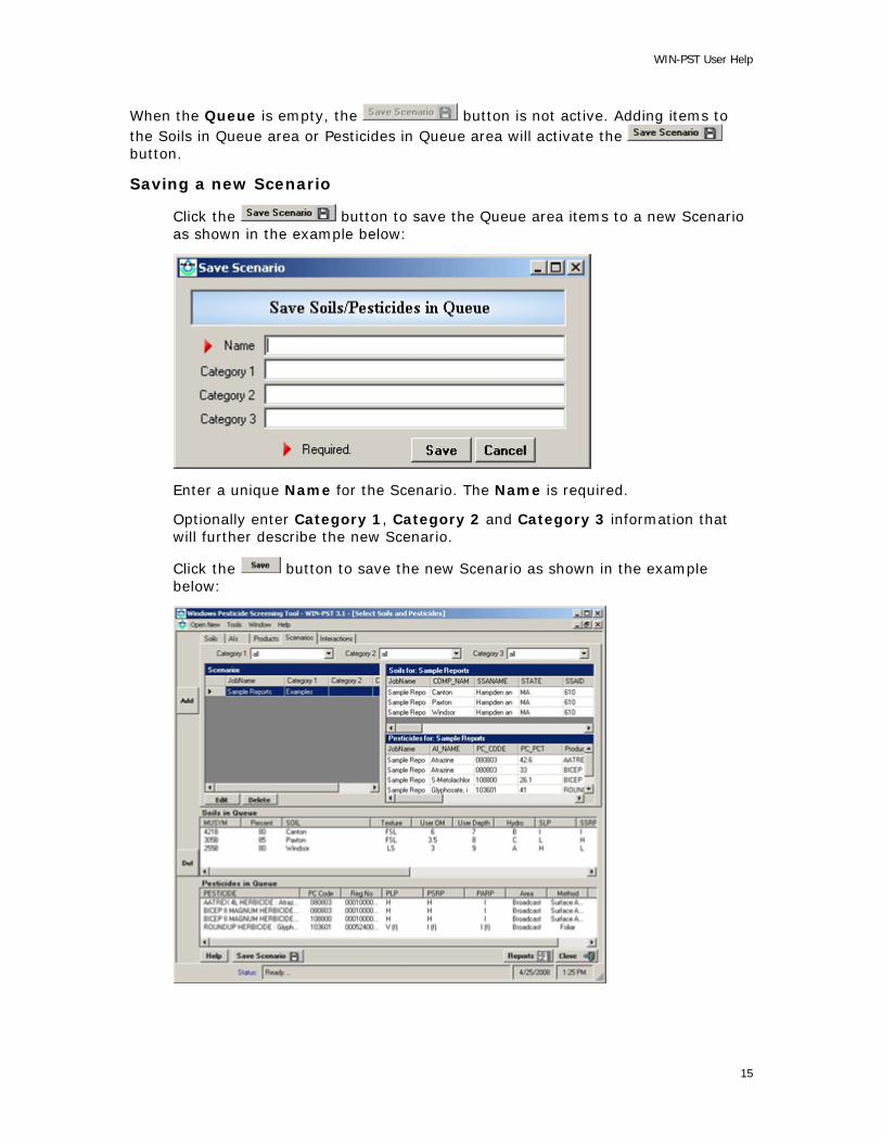
When the Queue is empty, the button is not active. Adding items to the Soils in Queue area or Pesticides in Queue area will activate the button.
Saving a new Scenario
Click the button to save the Queue area items to a new Scenario as shown in the example below:
Enter a unique Name for the Scenario. The Name is required.
Optionally enter Category 1, Category 2 and Category 3 information that will further describe the new Scenario.
Click the button to save the new Scenario as shown in the example below:
15

WIN-PST 3.1 User Help
Editing a Scenario
To edit a Scenario, first select a Scenario row in the Scenarios grid and then
click the button. The Update Scenario screen will display as shown in the example below:
Change the Category 1, Category 2 or Category 3 information as necessary. Click the button to save the changes.
Deleting a Scenario
You can select and delete multiple Scenarios at one time.
To select more than one Scenario row, select one row, then hold the Control key and select each of the other rows.
To select a continuous list of Scenario rows, select one row, then hold the Shift key and select the last row.
16

WIN-PST User Help
The example below shows one selected Scenario row in the Scenarios grid:
To delete the selected Scenarios, click the button. The Delete Scenario screen will display as shown in the example below:
17

WIN-PST 3.1 User Help
Click the button to complete the delete process. The updated Scenarios page will display as shown in the example below:
18

WIN-PST User Help
Interactions Tab
Choose the Interactions tab in the WIN-PST Desktop. The following example screen is displayed:
Rainfall - Probability of rainfall. Select Low or High (default). See Adjustments for more information.
19

WIN-PST 3.1 User Help
Data Grid Columns
WIN-PST has numerous Data Grids that display tabular data in rows and columns. In some cases, Data Grid column header names must be abbreviated for size limitations.
The Data Grids described on this page are:
1. Soils
2. Active Ingredients
3. Products
4. Interactions
Soils - The Soils Data Grid columns are:
MUSYM Mapunit Symbol. Used in the COMP table from NASIS or the SSSD. The symbol used to identify the soil mapunit on the soil map. (SSSD User's Manual - Appendix A-17.) PCT_COMP Component Percent. COMP_NAME Component Name. TEXTURE Soil Texture. HYDRO Hydrologic Soil Group. USER_OM A value that represents percent organic matter in the first soil horizon. The value comes from the Soils database and can be changed by the user based on the site conditions. USER_DEPTH A value that represents the Depth of the soil surface horizon. The value comes from the Soils database and can be changed by the user based on the site conditions. KFACT Soil Erodibility Factor. SLOPEGR15 Field slope greater than 15%. CRACKSGR24 Surface Connected Macropores (cracks) at least 24 inches deep.
20
WIN-PST User Help
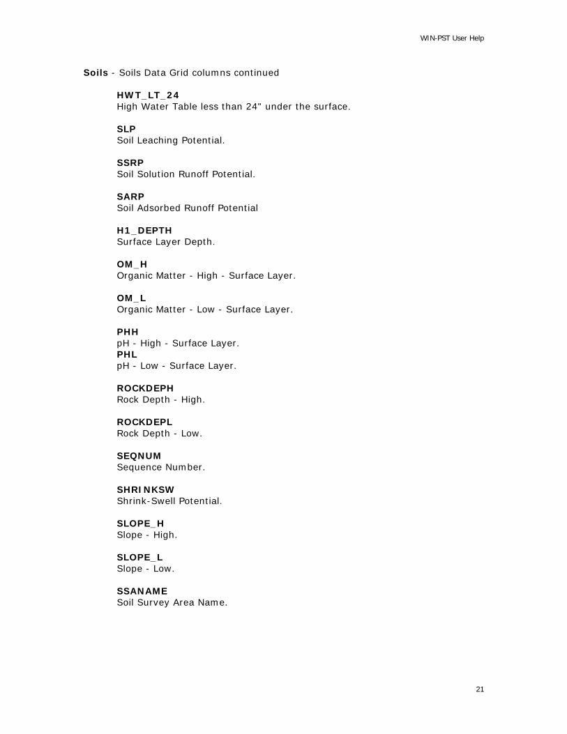
Soils - Soils Data Grid columns continued HWT_LT_24 High Water Table less than 24" under the surface. SLP Soil Leaching Potential. SSRP Soil Solution Runoff Potential. SARP Soil Adsorbed Runoff Potential H1_DEPTH Surface Layer Depth. OM_H Organic Matter - High - Surface Layer. OM_L Organic Matter - Low - Surface Layer. PHH pH - High - Surface Layer. PHL pH - Low - Surface Layer. ROCKDEPH Rock Depth - High. ROCKDEPL Rock Depth - Low. SEQNUM Sequence Number. SHRINKSW Shrink-Swell Potential. SLOPE_H Slope - High. SLOPE_L Slope - Low. SSANAME Soil Survey Area Name.
21

WIN-PST 3.1 User Help
Soils - Soils Data Grid columns continued WTBEG Water Table Beginning. WTDEPH Water Table Depth - High. WTDEPL Water Table Depth - Low. WTEND Water Table End. WTKIND Water Table Kind
Active Ingredients - The AIs Data Grid columns are:
Name Active Ingredient Name. PCCode EPA Pesticide Chemcial Code. PH pH of associated properties. HL Field Half Life. KOC Soil Organic Carbon Sorption Coefficient. SOL Solubility in Water. APP_AREA A user-selectable value for the Application Area:
Broadcast application (default) - applied to more than 1/2 of the field. Banded application - applied to 1/2 of the field or less. Spot application - applied to 1/10th of the field or less.
APP_METH A user-selectable value for the Application Method:
Surface applied (default) - applied to the soil surface Soil incorporated - with light tillage or irrigation. Foliar application - directed spray at nearly full crop/weed canopy.
22

WIN-PST User Help
Active Ingredients - AIs Data Grid columns continued APP_RATE A user-selectable value for the Application Rate:
Standard rate (default) - a label rate greater than 1/4 lb active ingredient per acre (280 g/ha). Low rate - a rate of 1/10 to 1/4 lb active ingredient per acre (112 to 280 grams per hectare). Ultra low rate - a rate of 1/10 lb or less active ingredient per acre (112 grams per hectare).
PLP Pesticide Leaching Potential. PSRP Pesticide Solution Runoff Potential PARP Pesticide Adsorbed Runoff Potential HumanTox Human Toxicity Value - Long Term HumanToxType Human Toxicity Type MATC Maximum Acceptable Toxicant Concentration - Fish. STV Sediment Toxicity Value - Fish. EATHuman Exposure Adjusted Toxicity Value - Human. EATMATC Exposure Adjusted Toxicity Value - MATC - Fish. EATSTV Exposure Adjusted Toxicity Value for Sediment Toxicity - Fish.
Products - The Products Data Grid columns are: Name Product Name. EPA Reg. No. EPA Product Registration Number. PC_Name Active Ingredient Name.
23

WIN-PST 3.1 User Help
Products - Products Data Grid columns continued PC_Code EPA's Pesticide Chemical Code. PC_Pct Active Ingredient Percent. APP_AREA A user-selectable value for the Application Area:
Broadcast application (default) - applied to more than 1/2 of the field. Banded application - applied to 1/2 of the field or less. Spot application - applied to 1/10th of the field or less.
APP_METH A user-selectable value for the Application Method:
Surface applied (default) - applied to the soil surface Soil incorporated - with light tillage or irrigation. Foliar application - directed spray at nearly full crop/weed canopy.
APP_RATE A user-selectable value for the Application Rate:
Standard rate (default) - a label rate greater than 1/4 lb active ingredient per acre (280 g/ha). Low rate - a rate of 1/10 to 1/4 lb active ingredient per acre (112 to 280 grams per hectare). Ultra low rate - a rate of 1/10 lb or less active ingredient per acre (112 grams per hectare).
Type_Code The Type Code.
24

WIN-PST User Help
Interactions - The Interactions Data Grid columns are:
Interaction Interaction of Soil and Pesticide. ILP Soil / Pesticide Interaction Leaching Potential. ISRP Soil / Pesticide Interaction Solution Runoff Potential. IARP Soil / Pesticide Interaction Adsorbed Runoff Potential. LH-H Leaching Hazard - Human. LH-F Leaching Hazard - Fish. SRH-H Solution Runoff Hazard - Human. SRH-F Solution Runoff Hazard - Fish. ARH-F Adsorbed Runoff Hazard - Fish.
25
WIN-PST 3.1 User Help
Data Management
Data Management - Introduction
The Data Management screen contains a number of tab selection screens that allow you to work with various types of WIN-PST data. The tab selections are:
1. Soils - See Soils for detailed information on viewing or changing your current SSURGO database location.
2. Active Ingredients - See Active Ingredients for detailed information regarding assigning Alternate Names.
3. Products - See Products for detailed information regarding Product selections.
4. Main Database - See Main Database for detailed information on viewing or changing your current MAIN database location.
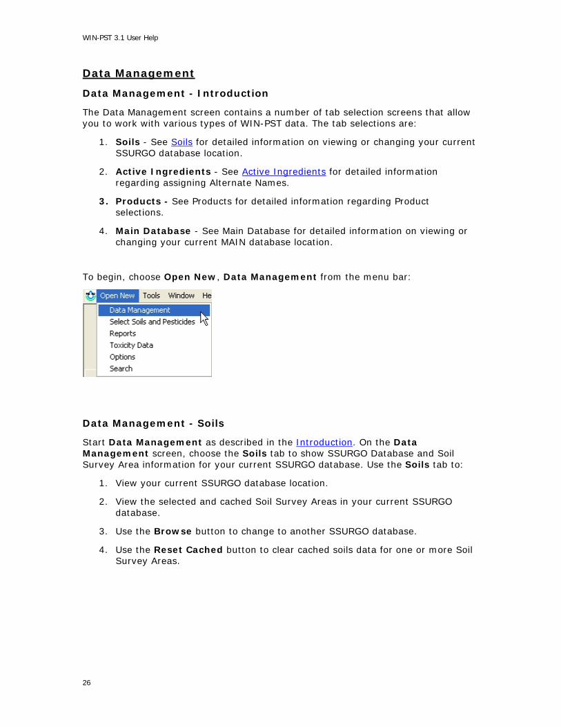
To begin, choose Open New, Data Management from the menu bar:
Data Management - Soils
Start Data Management as described in the Introduction. On the Data Management screen, choose the Soils tab to show SSURGO Database and Soil Survey Area information for your current SSURGO database. Use the Soils tab to:
1. View your current SSURGO database location.
2. View the selected and cached Soil Survey Areas in your current SSURGO database.
3. Use the Browse button to change to another SSURGO database.
4. Use the Reset Cached button to clear cached soils data for one or more Soil Survey Areas.
26

WIN-PST User Help
Select the Data Management, Soils tab as shown in the example below:
On the example screen above, the Database location contains the location and file name of the Sample SSURGO Database.
Sample SSURGO Database information Location: C:\Program Files\USDA\WIN-PST 3.1\Sample Database: SSURGO.mdb
The Soils tab displays additional information about the SSURGO Database including:
Size - the size of the SSURGO Database in MB.
Created - Date and time the file was created.
# Selected - The number of selected (checked) Soil Survey Areas.
# Cached - The number of cached Soil Survey Areas.
Each Soil Survey Area in the SSURGO Database is listed with:
Soil Survey Area - The Soil Survey Area name.
Count - The number of soils data rows.
Cached - A 'Y' if it is cached in the Main Database.
Version - The Version number.
Note: Older SSURGO Database files may not contain this information.
Version Date - The Version Date.
Note: Older SSURGO Database files may not contain this information.
Selecting Another SSURGO Database
If you are not currently using the Sample SSURGO database and you want to use the Sample SSURGO database, you can quickly change to it by selecting the checkbox
for Use Sample SSURGO database a s shown below:
27

WIN-PST 3.1 User Help
In the examples below, several SSURGO database files were placed in the following location:
The location, C:\SoilsData, contains two SSURGO database files:
soildb_MA_2002.mdb - Contains multiple Massachusetts Soil Survey Areas.
soildb_OR_2002.mdb - Contains a single Oregon Soil Survey Area.
On the Data Management, Soils tab, click the button to locate a SSURGO database file:
Select the SSURGO database file and click to continue.
28
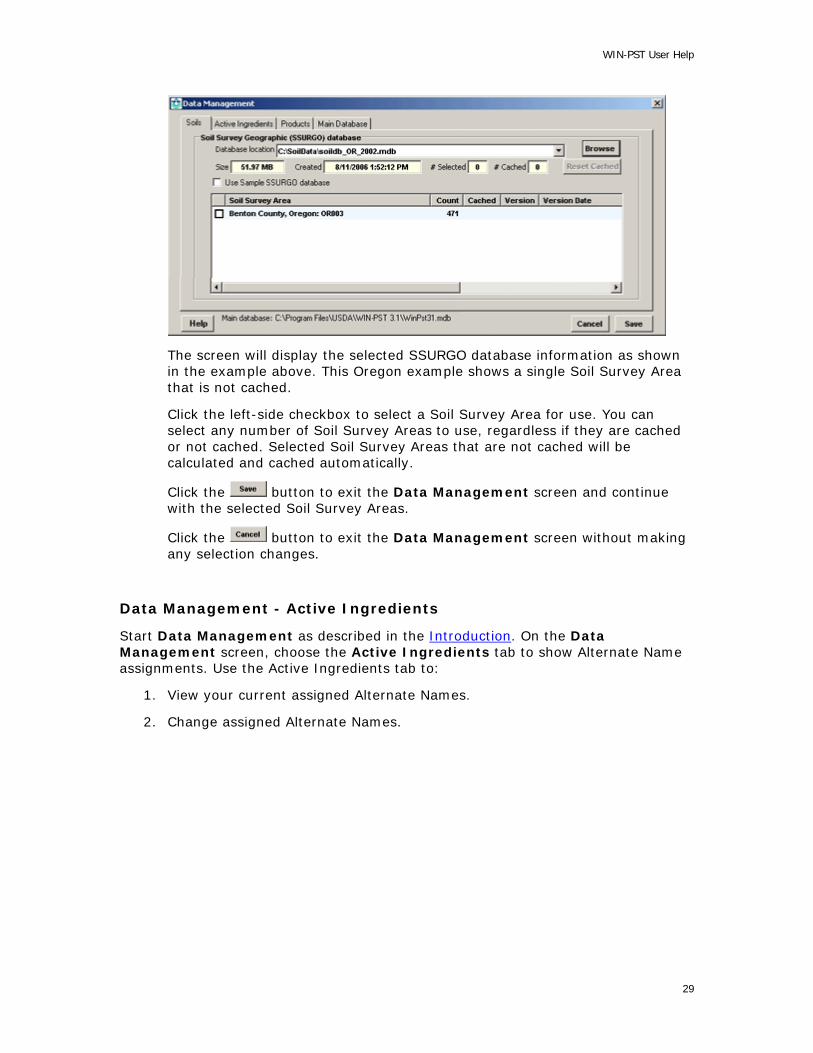
WIN-PST User Help
The screen will display the selected SSURGO database information as shown in the example above. This Oregon example shows a single Soil Survey Area that is not cached.
Click the left-side checkbox to select a Soil Survey Area for use. You can select any number of Soil Survey Areas to use, regardless if they are cached or not cached. Selected Soil Survey Areas that are not cached will be calculated and cached automatically.
Click the button to exit the Data Management screen and continue with the selected Soil Survey Areas.
Click the button to exit the Data Management screen without making any selection changes.
Data Management - Active Ingredients
Start Data Management as described in the Introduction. On the Data Management screen, choose the Active Ingredients tab to show Alternate Name assignments. Use the Active Ingredients tab to:
1. View your current assigned Alternate Names.
2. Change assigned Alternate Names.
29

WIN-PST 3.1 User Help
Select the Data Management, Active Ingredients tab:
Data Management - Products
Start Data Management as described in the Introduction. On the Data Management screen, choose the Products tab to show Current Selections. Use the Products tab to:
1. View your Current Selections.
2. Change Current Selections.
Select the Data Management, Products tab:
30

WIN-PST User Help
Data Management - Main Database
Start Data Management as described in the Introduction. On the Data Management screen, choose the Main Database tab to show location and cached information for your current Main database. Use the Main Database tab to:
1. View your current Main database location and other information.
2. Use the Browse button to locate another Main database.
3. Use the Change DB button to change to another Main database
4. Use the Delete Cached button to clear cached soils data for one or more Soil Survey Areas.
Select the Data Management, Main Database tab as shown in the example below:
Change The Main Database
If you are not currently using the default Main database and you want to use the default Main database, you can quickly change to it by selecting the checkbox for Use default Main database as shown below:
31
WIN-PST 3.1 User Help
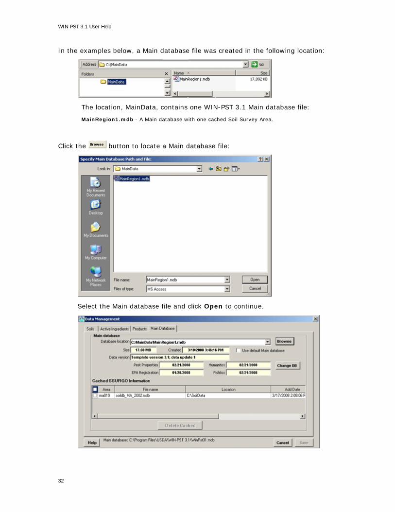
In the examples below, a Main database file was created in the following location:
The location, MainData, contains one WIN-PST 3.1 Main database file:
MainRegion1.mdb - A Main database with one cached Soil Survey Area.
Click the button to locate a Main database file:
Select the Main database file and click Open to continue.
32

WIN-PST User Help
The screen will display the selected Main database information as shown in the example above.
Click the button to change to this Main database and the Soils tab screen will display with the new Main database name showing at the bottom of the screen as shown in the example below:
The above example shows one Soil Survey Area selected from the Sample SSURGO database.
You can use the button to select another SSURGO database.
Be sure to select one or more of the Soil Survery Areas from the SSURGO database and click the button to exit Data Management.
33
WIN-PST 3.1 User Help
Databases
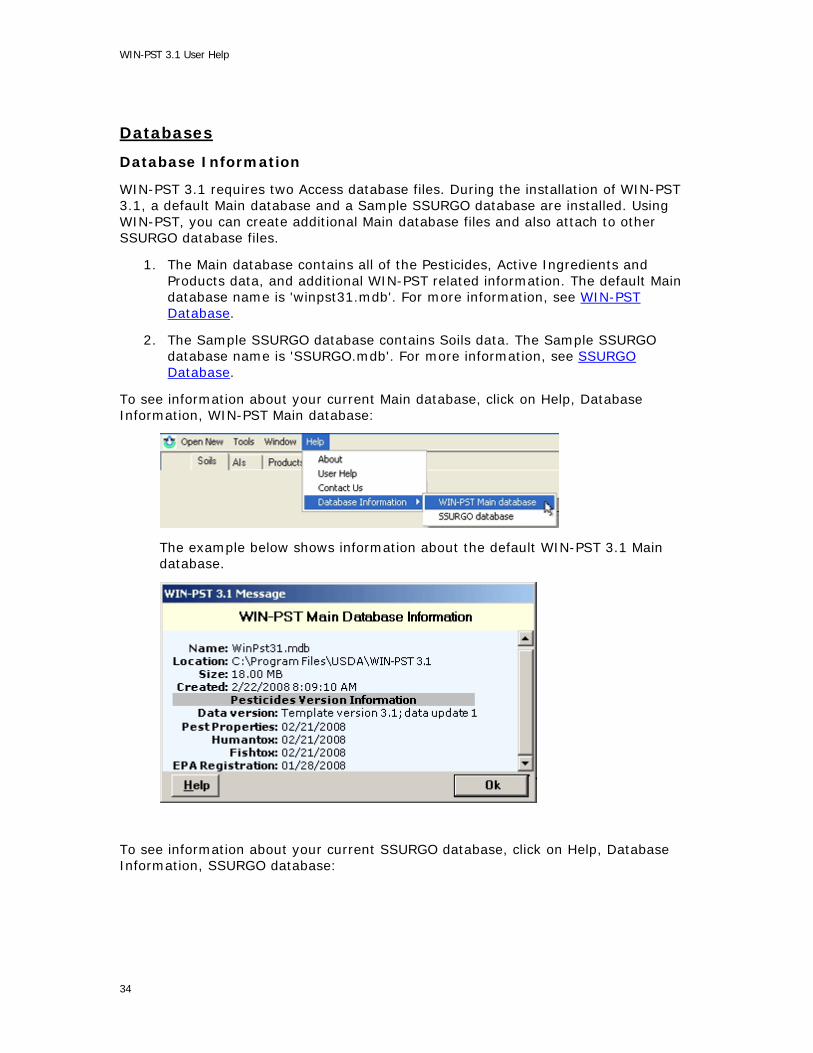
Database Information
WIN-PST 3.1 requires two Access database files. During the installation of WIN-PST 3.1, a default Main database and a Sample SSURGO database are installed. Using WIN-PST, you can create additional Main database files and also attach to other SSURGO database files.
1. The Main database contains all of the Pesticides, Active Ingredients and Products data, and additional WIN-PST related information. The default Main database name is 'winpst31.mdb'. For more information, see WIN-PST Database.
2. The Sample SSURGO database contains Soils data. The Sample SSURGO database name is 'SSURGO.mdb'. For more information, see SSURGO Database.
To see information about your current Main database, click on Help, Database Information, WIN-PST Main database:
The example below shows information about the default WIN-PST 3.1 Main database.
To see information about your current SSURGO database, click on Help, Database Information, SSURGO database:
34

WIN-PST User Help
The example below shows information about the Sample SSURGO database.
SSURGO Database
WIN-PST uses a SSURGO database to obtain soils information. Data from the Soil Data Mart is distributed in what is referred to as “SSURGO” format.
During the WIN-PST 3.1 installation, a Sample SSURGO database is installed. The Sample SSURGO database is provided to help you quickly start using WIN-PST 3.1 and it only contains two Soil Survey Areas:
1. Hampden and Hampshire Counties, Massachusetts, Western Part: MA608
2. Hampden and Hampshire Counties, Massachusetts, Eastern Part: MA610
The first time you start WIN-PST 3.1 you will be asked to identify the SSURGO database to use. At any time, you can easily select the Sample SSURGO database on the Soils tab in Data Management as shown in this example:
Soil survey data can be downloaded from the Soil Data Mart at:
http://soildatamart.nrcs.usda.gov
Data for a soil survey area includes a tabular component and a spatial component. The tabular component is typically imported into a database for querying, reporting
35

WIN-PST 3.1 User Help
and analysis. The spatial component is typically viewed and analyzed using a Geographic Information System (GIS).
WIN-PST Template SSURGO Error Message
Connecting to a 'SSURGO template database' will result in the following example error message:
To correct this error condition, follow the steps in section 'Using a Soil Data Mart SSURGO database.
Using a Soil Data Mart SSURGO database
If you receive a Template SSURGO error message when you attempt to connect to a SSURGO database file, the SSURGO database is still a 'SSURGO template database' and it must have the tabular soil data imported into it. This section explains the tabular soil data import process.
When soil data is exported from the Soil Data Mart, the end result is always a single zip file, regardless of what export options were selected.
In a SSURGO template database, the SSURGO database structure has already been created. Tabular soil data can be imported by running a macro that resides in the database. In order to use this database, you have to have Microsoft Access installed on your PC.
The examples below use a temporary directory location of C:\Work and a 'soil_ca021.zip' file.
Note: Be sure to substitute your directory location and file name.
Step 1 - Unzip
The file 'soil_ca021.zip' is a SSURGO export file downloaded from the Soil Data Mart.
36

WIN-PST User Help
A SSURGO export file can be unzipped using WinZip or an equivalent application. When an export file is unzipped, the following directory hierarchy is produced in the directory to which the export file was unzipped:
soil_ssasymbol (e.g., soil_ca021, soil_co630, soil_ky033, soil_ne075)
tabular
spatial
Step 2 - Unzip the Microsoft Access database
The file 'soildb_CA_2002.zip' is a zipped Microsoft Access database, into which the tabular soil data can be imported. This file will only exist if the person who generated this export requested its inclusion. The embedded Microsoft Access database is referred to as a 'SSURGO template database'.
Unzip the soildb_CA_2002.zip' into the same directory to which the export file was unzipped.
Step 3 - Import the tabular data
Open the unzipped database 'soildb_CA_2002.mdb'.
37

WIN-PST 3.1 User Help
Enter the directory location of the 'tabular' data and click the OK button.
Following the tabular data import, click the Exit button to close Microsoft Access.
38

WIN-PST User Help
The SSURGO database is ready for use with WIN-PST and can be moved to another more permanent directory location if necessary.
Main Database
WIN-PST requires two Access database files, a Main database and a SSURGO soils database.
The Main database is the primary database for the WIN-PST application. It is used for the overall operation of the application and it also contains Pesticides, Active Ingredients and Products data. A 'default' Main database, named 'winpst31.mdb, is created when WIN-PST 3.1 is installed. This 'default' Main database comes pre-configured to work with the installed Sample SSURGO Database and it contains cached soils information. See Caching Introduction for more information on caching soils information.
Additionally, the Main database also stores saved Scenarios. See the Scenarios Tab for more information.
You can continue to use the 'default' Main database or you can create additional Main database files as necessary. See Create Database for more information on creating a new Main database.
39

WIN-PST 3.1 User Help
WIN-PST uses one Main database file at a time. See Change Main Database for more information on how to change to another Main database. See Database Information for more information about your current Main and SSURGO databases.
Change Main Database
WIN-PST 3.1 requires a valid Main database to operate properly. Use the Create Database feature to create additional Main database files or use the 'default' Main database created during the installation of WIN-PST. For more information, see Database Information.
When you change the Main database, you will also need to select a SSURGO Database.
For detailed information on changing the Main database, see Data Management, Main Database.
Change SSURGO Database
WIN-PST requires two Access database files, the WIN-PST Main database and a SSURGO soils database. For more information, see SSURGO Database.
WIN-PST 3.1 requires a valid SSURGO database to operate properly. For more information about WIN-PST databases, see Database Information.
For detailed information on changing the SSURGO database, see Data Management, Soils.
40

WIN-PST User Help
Caching Soils Data
Caching Introduction
WIN-PST uses soils data taken directly from a SSURGO Database. Before WIN-PST can use the SSURGO soils data, a lengthy calculation process is required.
Caching is a new feature in WIN-PST 3.1. When you initially select one or more SSURGO Database Soil Survey Areas, the calculation process runs once and the calculated results are cached in the Main Database for future rapid retrieval. You can select one or more Soil Survey Areas from a SSURGO Database for your use.
When you cache soils data, information about the source SSURGO Database file is also saved. If you delete or change the source SSURGO Database file, WIN-PST will automatically remove all cached soils information that came from the source SSURGO Database file. In this way, WIN-PST will only keep current SSURGO soils data cached.
When WIN-PST is installed, the default Main Database contains cached soils data for the Sample SSURGO Database. If you change to another SSURGO database, you can delete the cached soils data for the Sample SSURGO Database.
See Soils for more about the Data Management, Soils tab.
To see your current cached soils information, go to the Data Management, Soils tab.
The following example Data Management screen will display:
On the example screen above, the Database location contains the location and file name of the Sample SSURGO Database.
Sample SSURGO Database information Location: C:\Program Files\USDA\WIN-PST 3.1\Sample Database: SSURGO.mdb
The Data Management screen displays additional information about the SSURGO Database including:
Size - the size of the SSURGO Database in MB.
Created - Date and time the file was created.
# Selected - The number of selected (checked) Soil Survey Areas.
# Cached - The number of cached Soil Survey Areas.
41

WIN-PST 3.1 User Help
Each Soil Survey Area in the SSURGO Database is listed with:
Soil Survey Area - The Soil Survey Area name.
Count - The number of soils data rows.
Cached - A 'Y' if it is cached in the WIN-PST Main Database.
Version - The Version number. Note: Older SSURGO Database files may not contain this information.
Version Date - The Version Date. Note: Older SSURGO Database files may not contain this information.
Data Management: Caching
Reset Cached - The Data Management, Soils tab shows SSURGO Database and Soil Survey Area information for your current SSURGO database. On the Soils tab, you can use the Reset Cached button to delete cached information stored in the Main database for one or more Soil Survey Areas in your current SSURGO database.
Delete Cached - The Data Management, Main Database tab shows Main Database and all cached SSURGO information for your current Main database. A Main database can store cached information for numerous SSURGO databases. On the Main Database tab, you can use the Delete Cached button to delete cached information stored in the Main database for one or more Soil Survey Areas from one or more SSURGO databases.
Reset Cached - Current SSURGO Database
The following example Data Management, Soils tab screen shows the Sample SSURGO database with two cached Soil Survey Areas:
Click the left-side checkbox for each Soil Survey Area to reset as shown in the example screen below:
42

WIN-PST User Help
Click the button and the following example message will display:
Click the Yes button to reset (delete) the cached Soil Survey Area data from the Main database. The Soils tab screen will show that the cached information was reset as shown in the example below:
Delete Cached - Current Main Database
The following example Data Management, Main Database tab screen shows the default Main Database that contains cached SSURGO soils information:
43

WIN-PST 3.1 User Help
The above example shows:
• Area or003 - One Soil Survey Area cached from the soildb_OR_2002.mdb SSURGO database located at C:\SoilData
• Area ma608 and ma610 - Two Soil Survey Areas cached from the SSURGO.mdb Sample SSURGO database located at C:\Program Files\USDA\WIN-PST 3.1\Sample
Click the left-side checkbox for each Soil Survey Area to delete:
The above example shows that Area ma608 and ma610, from the Sample SSURGO database, are selected. The Delete Cached button is enabled and shows that (2) areas are selected.
Click the button to continue and the following example message will display:
44

WIN-PST User Help
Click the Yes button to delete the cached Soil Survey Area data from the Main database. The Main Database tab screen will show that the cached information was deleted as shown in the example below:
Working with the Queue
Queue Introduction
The Queue, located on the bottom half of the Select Soils and Pesticides screen, is a holding area for items that you select from the Soils, Active Ingredients, and Products grids. You can also add Scenarios to the Queue. The Queue is a convenient way to combine selected Soils, Active Ingredients and Products.
Selected Soils items added to the Queue go into the Soils in Queue area, and selected Active Ingredients (AIs) and Products go into the Pesticides in Queue area.
Reports and Exports work directly with the items contained in the Queue. You can also save the contents of the Queue into a Scenario for easy retrieval at a later time.
On the Select Soils and Pesticides screen you will find the Soils Tab, AIs Tab, Products Tab, Scenarios Tab and Interactions Tab. All of these tab screens share the same Queue area.
45
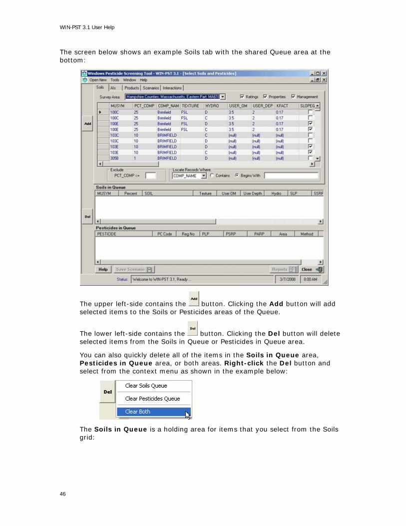
WIN-PST 3.1 User Help
The screen below shows an example Soils tab with the shared Queue area at the bottom:
The upper left-side contains the button. Clicking the Add button will add selected items to the Soils or Pesticides areas of the Queue.
The lower left-side contains the button. Clicking the Del button will delete selected items from the Soils in Queue or Pesticides in Queue area.
You can also quickly delete all of the items in the Soils in Queue area, Pesticides in Queue area, or both areas. Right-click the Del button and select from the context menu as shown in the example below:
The Soils in Queue is a holding area for items that you select from the Soils grid:
46

WIN-PST User Help
The Pesticides in Queue is a holding area for items that you select from the Active Ingredients (AIs) and Products grids:
Queue Maintenance
Activities
• Add one or more new items to the Queue.
• Delete one, some or all items from the Queue.
• Items in the Queue cannot be modified. Edit items in the Soils, Active Ingredients or Products grids before selecting and adding them to the Queue.
Overview
The Queue is a shared area for holding selected Soils and Pesticides. The Queue Introduction page identifies and describes the various parts of the Queue. This document describes adding and deleting Queue items.
When the Queue is empty, the Save Scenario and Reports buttons are not active. Adding items to the Soils in Queue area or Pesticides in Queue area will activate the Save Scenario and Reports buttons.
Adding Soils
Selected Soils items from the Soils grid and saved Scenarios can be added to the Soils in Queue area. The example below shows one selected Soils row in the Soils grid:
47

WIN-PST 3.1 User Help
Click the button to add the selected Soils row to the Soils in Queue area as shown in the example below:
You can select and add multiple Soils rows at one time as shown in the example below.
48

WIN-PST User Help
To select more than one Soils row, select one row, then hold the Control key and select each of the other rows.
To select a continuous list of Soils rows, select one row, then hold the Shift key and select the last row.
Click the button to add the two selected Soils rows to the Soils in Queue area as shown in the example below:
49

WIN-PST 3.1 User Help
Adding AIs and Products
Selected Pesticides items from the Active Ingredients (AIs) and Products grids and saved Scenarios can be added to the Pesticides in Queue area. Selecting and adding Active Ingredients (AIs) and Products items are very similar and this section only shows a Products row example.
The example below shows one selected Products row in the Products grid:
Click the button to add the selected Products row to the Pesticides in Queue area as shown in the example below:
50

WIN-PST User Help
See the previously explained Adding Soils section for more information on selecting and adding more than one row.
Adding Scenarios
Selected Scenarios can be added to the Queue areas. The Soils and Pesticides items in the selected Scenario will be added to the Soils in Queue and Pesticides in Queue areas.
51

WIN-PST 3.1 User Help
The example below shows a selected Scenario:
Click the button to add the selected Scenario to the Queue areas as shown in the example below:
Only one Scenario can be selected and added to the Queue at a time.
52

WIN-PST User Help
You can continue selecting additional Scenarios and adding their contents to the Queue area. The Queue area will accumulate the contents of all the added Scenarios.
Deleting Queue Soils and Pesticides
Items in the Queue can be removed in two ways:
1. Selecting and deleting individual Soils or Pesticides items, or
2. Clearing all items in the Soils in Queue, Pesticides in Queue or both Queue areas.
The example below shows a selected Soils in Queue row:
Click the button to delete the selected row from the Soils in Queue area.
Use the same process to select and delete rows from the Pesticides in Queue area.
You can select and delete multiple rows at one time.
To select more than one row, select one row, then hold the Control key and select each of the other rows.
To select a continuous list of rows, select one row, then hold the Shift key and select the last row.
Right-click the button to see the three selections available for clearing items from the Queue areas. The example below explains the second way to delete Queue items:
To delete all of the Soils in Queue items, right-click the button and select . All of the items in the Soils in Queue area will be removed.
53

WIN-PST 3.1 User Help
To delete all of the Pesticides in Queue items, right-click the button and select . All of the items in the Pesticides in Queue area will be removed.
To delete all of the Soils in Queue and Pesticides in Queue items, right-click
the button and select . All of the items in the Soils in Queue and Pesticides in Queue areas will be removed.
Reports and Exports
Reports and Exports Introduction
WIN-PST produces a number of reports and offers several export formats.
Note: The Reports button is active when you have added Soils, Active Ingredients or Products to the Queue. The content for all reports comes directly from the items in the Queue.
See Queue Maintenance for more information.
The WIN-PST reports are:
1. Soil Sensitivity to Pesticide Loss Rating Report (Soils)
2. Pesticide Active Ingredient Rating Report (Pesticides)
3. Soil / Pesticide Interaction Loss Potential and Hazard Rating Report (Interactions)
The WIN-PST exports are:
1. SoilData (Soils)
2. ChemData (Pesticides)
3. InteractionData (Interactions)
54

WIN-PST User Help
To see the Reports (and Exports) screen, click the button on the Select Soils and Pesticides screen. The following example screen will display:
Create a Report explains how to create a WIN-PST report.
Create an Export explains how to create a WIN-PST export file.
Create a Report
The top half of the Reports screen relates to report creation. On this screen you can:
1. Assign User Data to the report.
2. Select one or more report types for creation.
3. Customize each type of report to show specific data elements.
4. Select a Printer.
5. Select a PDF folder location.
6. Preview, Print or create a PDF report file.
55

WIN-PST 3.1 User Help
Note: Reports are derived from the items in the Queue. The Queue must contain one or more Soils in order to produce a Soils Report. The Queue must contain one or more Pesticides in order to produce a Pesticides Report. The Queue must contain one or more Soils and Pesticides in order to produce an Interactions Report.
The example Reports screen above shows default settings without User Data and without Selected Reports selections.
User Data
To add User Data to a report:
• Select the User Data checkbox.
• Enter Cooperator, Tract and Field data as necessary. These fields are optional.
To remove User Data from a report:
• De-select the User Data checkbox.
56

WIN-PST User Help
Select Reports
The following example shows selected checkboxes for all report types and all report type data elements:
Use the Select Reports checkboxes to select report types and specific report type data elements.
57

WIN-PST 3.1 User Help
Viewing a Report
After selecting one or more report types and optional User Data, click the button. All of the selected report types will display as shown in the
example below:
The above example shows a preview screen for each of the three report types selected. To see a partially hidden report, click on any visible portion of the report to bring it to the front.
Be sure to close each preview screen when you are done.
Printing a Report
After selecting one or more report types and optional User Data:
1. Select a destination printer:
2. Click the button and the selected report types will be sent to the destination Printer.
58

WIN-PST User Help
Creating a Report PDF file
PDF file creation will group selected report types together by assigning an incremental sequential number to the output file names. In the example below, all of the output file names start with '001-'. The sequential number added to the file names will increment each time you create PDF files.
After selecting one or more report types and optional User Data:
1. Select a destination folder:
2. Click the button to begin file creation for the selected report types.
3. When complete, the output PDF files will display as shown in the following example:
Create an Export
The bottom half of the Reports screen relates to the creation of export files. On this screen you can:
1. Select one or more export types for file creation.
2. Select one or more export formats for file creation.
3. Select a file folder location for each export type.
Note: Exports are derived from the items in the Queue. The Queue must contain one or more Soils in order to produce a Soils export. The Queue must contain one or more Pesticides in order to produce a Pesticides export. The Queue must contain one or more Soils and Pesticides in order to produce an Interactions export.
59
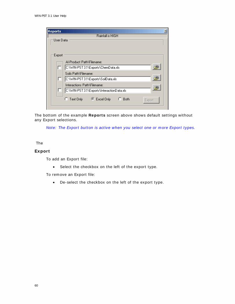
WIN-PST 3.1 User Help
The bottom of the example Reports screen above shows default settings without any Export selections.
Note: The Export button is active when you select one or more Export types.
The
Export
To add an Export file:
• Select the checkbox on the left of the export type.
To remove an Export file:
• De-select the checkbox on the left of the export type.
60

WIN-PST User Help
Select Reports
The following example shows selected checkboxes for all report types and all report type data elements:
Use the Select Reports checkboxes to select report types and specific report type data elements.
61
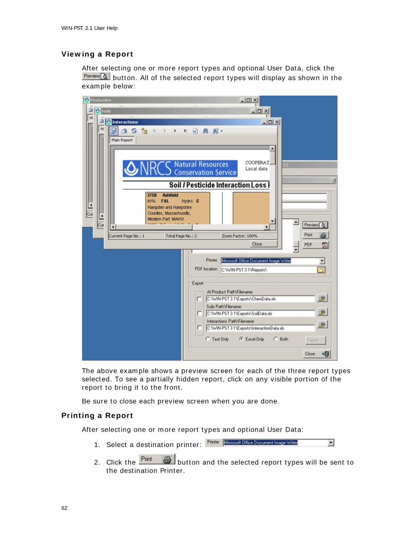
WIN-PST 3.1 User Help
Viewing a Report
After selecting one or more report types and optional User Data, click the button. All of the selected report types will display as shown in the
example below:
The above example shows a preview screen for each of the three report types selected. To see a partially hidden report, click on any visible portion of the report to bring it to the front.
Be sure to close each preview screen when you are done.
Printing a Report
After selecting one or more report types and optional User Data:
1. Select a destination printer:
2. Click the button and the selected report types will be sent to the destination Printer.
62

WIN-PST User Help
Creating a Report PDF file
PDF file creation will group selected report types together by assigning an incremental sequential number to the output file names. In the example below, all of the output file names start with '001-'. The sequential number added to the file names will increment each time you create PDF files.
After selecting one or more report types and optional User Data:
1. Select a destination folder:
2. Click the button to begin file creation for the selected report types.
3. When complete, the output PDF files will display as shown in the following example:
63
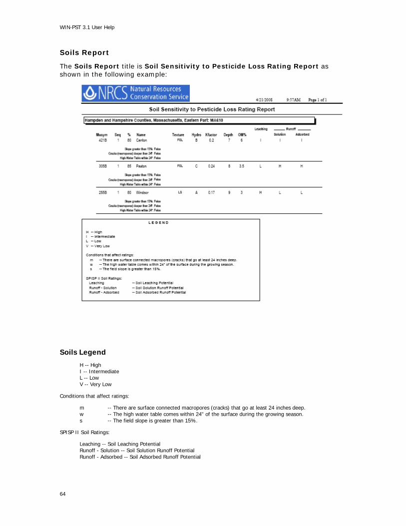
WIN-PST 3.1 User Help
Soils Report
The Soils Report title is Soil Sensitivity to Pesticide Loss Rating Report as shown in the following example:
Soils Legend
H -- High I -- Intermediate L -- Low V -- Very Low
Conditions that affect ratings:
m -- There are surface connected macropores (cracks) that go at least 24 inches deep. w -- The high water table comes within 24" of the surface during the growing season. s -- The field slope is greater than 15%.
SPISP II Soil Ratings:
Leaching -- Soil Leaching Potential Runoff - Solution -- Soil Solution Runoff Potential Runoff - Adsorbed -- Soil Adsorbed Runoff Potential
64

WIN-PST User Help
Pesticides Report
The Pesticides Report title is Pesticide Active Ingredient Rating Report as shown in the following examples:
65

WIN-PST 3.1 User Help
Pesticides Legend
X -- eXtra high H -- High I -- Intermediate L -- Low V -- Very low
Conditions that affect ratings:
(none) -- Broadcast application (default); applied to more than 1/2 the field b -- Banded application; applied to 1/2 the field or less p -- Spot application; applied to 1/10 of the field or less
(none) -- Surface applied (default); applied to the soil surface I -- Soil incorporated; with light tillage or irrigation f -- Foliar application; directed spray at nearly full crop/weed canopy
(none) -- Standard application rate (default); greater than 1/4 lb/acre l -- Low rate of application; 1/10 to 1/4 lb/acre <ul> -- Ultra Low rate of application; 1/10 lb/acre or less
SPISP II P-Ratings:
Leaching -- Pesticide Leaching Potential Runoff Solution -- Pesticide Solution Runoff Potential Runoff Adsorbed -- Pesticide Adsorbed Runoff Potential
66

WIN-PST User Help
Interactions Report
The Interactions Report title is Soil / Pesticide Interaction Loss Potential and Hazard Rating Report as shown in the following examples:
67

WIN-PST 3.1 User Help
Interactions Legend
X -- eXtra high H – High I – Intermediate L – Low V -- Very low
Conditions that affect ratings:
(none) -- Broadcast application (default); applied to more than 1/2 the field b -- Banded application; applied to 1/2 the field or less p -- Spot application; applied to 1/10th of the field or less
(none) -- Surface applied (default); applied to the soil surface i -- Soil incorporated; with light tillage or irrigation f -- Foliar application; directed spray at nearly full crop/weed canopy
(none) -- Standard application rate (default); greater than 1/4 lb/acre l -- Low rate of application; 1/10 to 1/4 lb/acre <ul> -- Ultra Low rate of application; 1/10 lb/acre or less
m -- There are surface connected macropores (cracks) that go at least 24 inches deep. w -- The high water table comes within 24" of the surface during the growing season. s -- The field slope is greater than 15%.
<none> -- Default condition for all climates that have rainfall/irrigation after pesticide application <dry> -- Exception for arid climates that have a low probability of rainfall and no irrigation after pesticide application
SPISP II I-Ratings:
Leaching -- Soil / Pesticide Interaction Leaching Potential Solution -- Soil / Pesticide Interaction Solution Runoff Potential Adsorbed -- Soil / Pesticide Interaction Adsorbed Runoff Potential
68

WIN-PST User Help
Tools
Introduction
The Tools menu allows you to perform various setup and configuration tasks.
The Tools, Options menu selection provides customization for your database files, reports and export file locations, tool tip settings, site conditions, colors and cached soils data.
To begin, choose Tools, Options from the menu bar:
The Tools, Database Utility menu selection provides functionality to create a new WIN-PST Main database or import saved Scenario information from another WIN-PST Main database.
To begin, choose Tools, Database Utility from the menu bar:
The Tools, Update Pesticides menu selection provides functionality to update your WIN-PST main database with the latest pesticides information.
To begin, choose Tools, Update Pesticides from the menu bar:
User Options
Start Tools, Options as described in the Introduction.
Databases
Choose the Databases tab to see your database file names and locations:
69

WIN-PST 3.1 User Help
If you are not currently using the default Main database and you want to use the default Main database, you can quickly change to it by selecting the checkbox for Use default Main database as shown below:
To locate another Main database, click the button within the Main database location area.
If you are not currently using the Sample SSURGO database and you want to use the Sample SSURGO database, you can quickly change to it by selecting the checkbox for Use Sample SSURGO database as shown below:
To locate another SSURGO database, click the button within the Soil Survey Geographic (SSURGO) database location area.
Locations
Choose the Locations tab to see your output Reports and Exports folder locations:
70

WIN-PST User Help
If you are not currently using the default Reports folder and you want to use the default Reports folder, you can quickly change to it by selecting the checkbox for Use default Reports folder as shown below:
To locate another Reports folder, click the button.
If you are not currently using the default Exports folder and you want to use the default Exports folder, you can quickly change to it by selecting the checkbox for Use default Exports folder as shown below:
To locate another Exports folder, click the button.
71
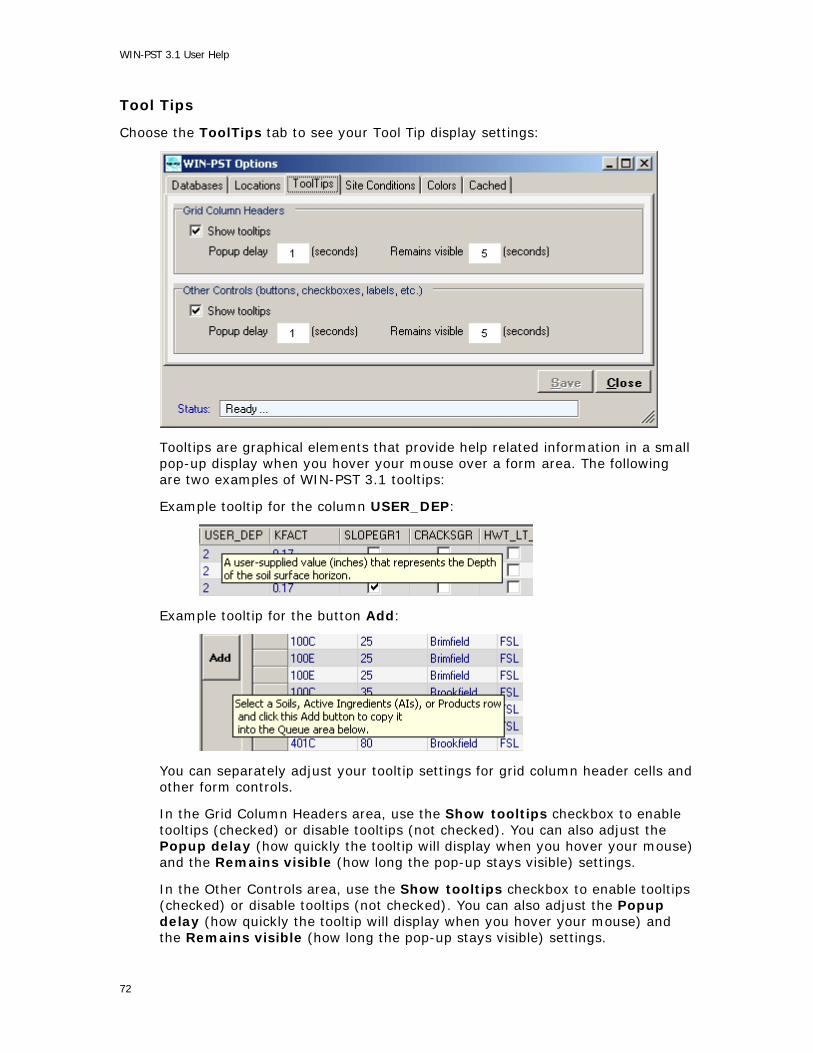
WIN-PST 3.1 User Help
Tool Tips
Choose the ToolTips tab to see your Tool Tip display settings:
Tooltips are graphical elements that provide help related information in a small pop-up display when you hover your mouse over a form area. The following are two examples of WIN-PST 3.1 tooltips:
Example tooltip for the column USER_DEP:
Example tooltip for the button Add:
You can separately adjust your tooltip settings for grid column header cells and other form controls.
In the Grid Column Headers area, use the Show tooltips checkbox to enable tooltips (checked) or disable tooltips (not checked). You can also adjust the Popup delay (how quickly the tooltip will display when you hover your mouse) and the Remains visible (how long the pop-up stays visible) settings.
In the Other Controls area, use the Show tooltips checkbox to enable tooltips (checked) or disable tooltips (not checked). You can also adjust the Popup delay (how quickly the tooltip will display when you hover your mouse) and the Remains visible (how long the pop-up stays visible) settings.
72

WIN-PST User Help
Site Conditions
Choose the Site Conditions tab to see your Rainfall setting:
Use the Rainfall radio button to set your default to Low or High.
Colors
Choose the Colors tab to see your text and alternating row display colors:
Use the Soils Grid area to adjust the Soils Tab grid row colors and text color.
Use the Data Management Grid area to adjust the Soils grid row colors and text color.
73
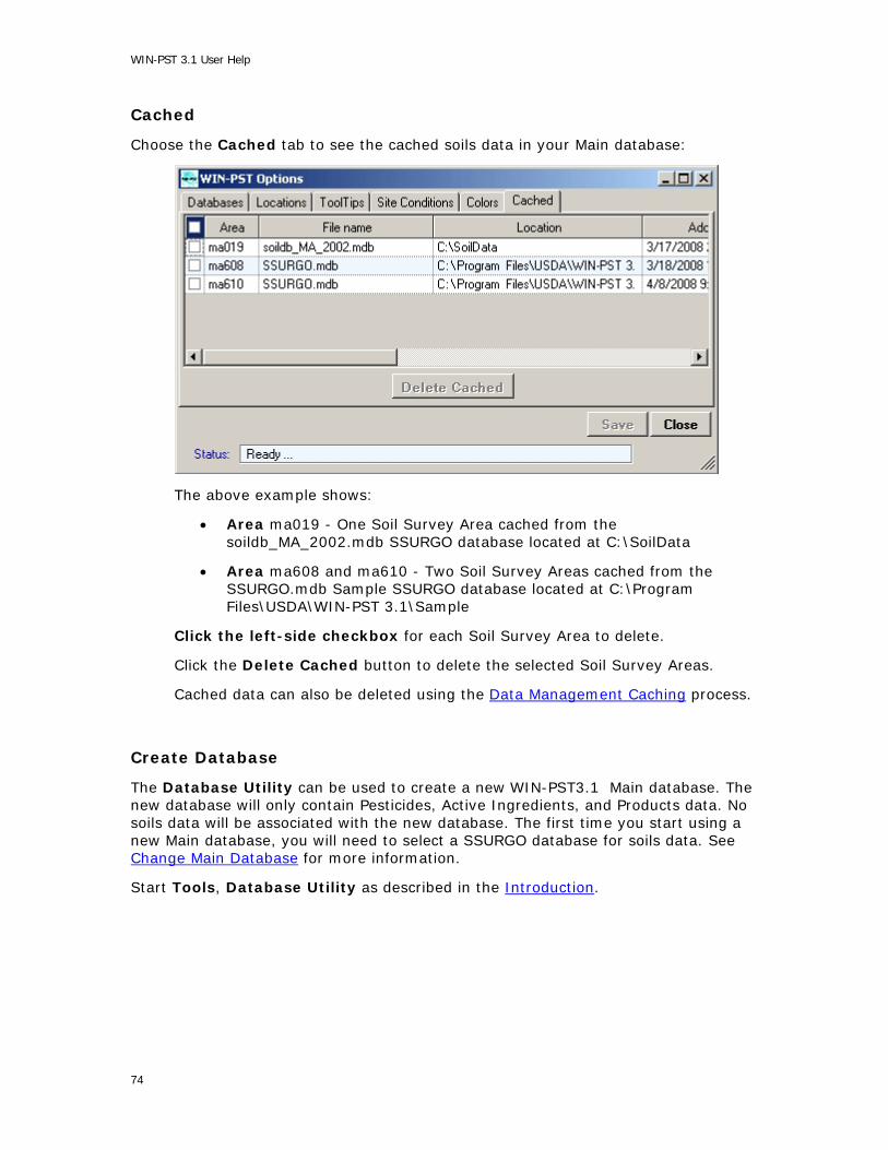
WIN-PST 3.1 User Help
Cached
Choose the Cached tab to see the cached soils data in your Main database:
The above example shows:
• Area ma019 - One Soil Survey Area cached from the soildb_MA_2002.mdb SSURGO database located at C:\SoilData
• Area ma608 and ma610 - Two Soil Survey Areas cached from the SSURGO.mdb Sample SSURGO database located at C:\Program Files\USDA\WIN-PST 3.1\Sample
Click the left-side checkbox for each Soil Survey Area to delete.
Click the Delete Cached button to delete the selected Soil Survey Areas.
Cached data can also be deleted using the Data Management Caching process.
Create Database
The Database Utility can be used to create a new WIN-PST3.1 Main database. The new database will only contain Pesticides, Active Ingredients, and Products data. No soils data will be associated with the new database. The first time you start using a new Main database, you will need to select a SSURGO database for soils data. See Change Main Database for more information.
Start Tools, Database Utility as described in the Introduction.
74

WIN-PST User Help
Create A New Main Database
The following Tools, Database Utility example screen will display:
Select the Create a new 3.1 Main database radio button as shown in the example above.
Click the Folder icon on the right side of the Location: to specify a location for the new Main database file. The following example shows the selection of a MainData folder:
Click OK to continue with the selected location.
75

WIN-PST 3.1 User Help
Enter a Main database file name in the File: textbox as shown in the following example:
Click Proceed to continue.
A message will display showing the created Main database information as shown in the example below:
Click Ok to continue.
Click Close to exit the Database Utility.
Import Scenarios
WIN-PST can save selected combinations of Soils, Active Ingredients, and Products into Scenarios. Each Scenario is given a JobName and optionally, up to 3 category descriptions. The Database Utility can import WIN-PST Scenario data from another WIN-PST Main database. Importing Scenario data can come from a WIN-PST 3.0 Main database or from a WIN-PST 3.1 Main database. The import process will capture all Scenarios.
76
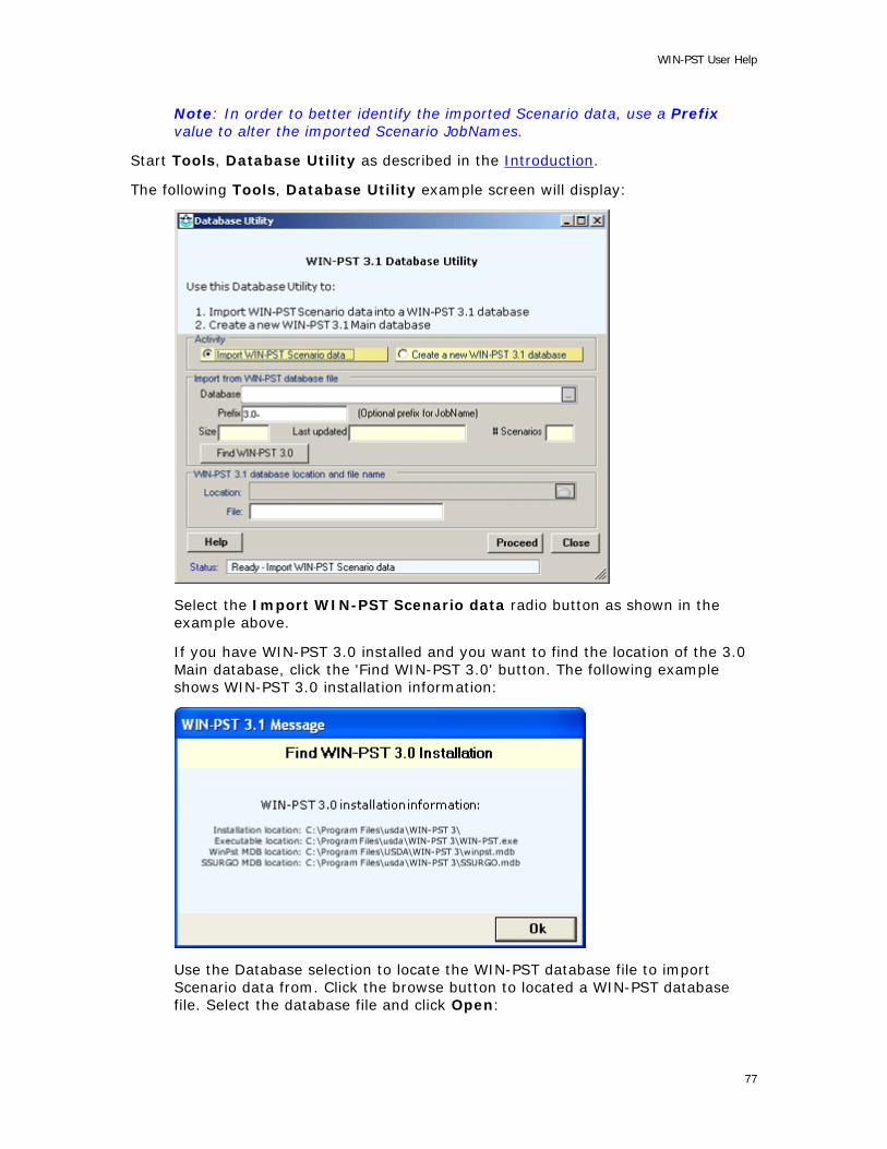
WIN-PST User Help
Note: In order to better identify the imported Scenario data, use a Prefix value to alter the imported Scenario JobNames.
Start Tools, Database Utility as described in the Introduction.
The following Tools, Database Utility example screen will display:
Select the Import WIN-PST Scenario data radio button as shown in the example above.
If you have WIN-PST 3.0 installed and you want to find the location of the 3.0 Main database, click the 'Find WIN-PST 3.0' button. The following example shows WIN-PST 3.0 installation information:
Use the Database selection to locate the WIN-PST database file to import Scenario data from. Click the browse button to located a WIN-PST database file. Select the database file and click Open:
77

WIN-PST 3.1 User Help
After selecting the database file, a message will display showing the number of Scenarios found as shown in this example below. Click OK to continue:
The selected database file will display showing the Size, Last Updated and # of Scenarios. Click Proceed to continue with the import process.
78

WIN-PST User Help
A 'Proceed With Import' message will display showing the source and destination databases. The example below shows 3 Scenarios ready to import from the default location WIN-PST 3.0 Main database into the default WIN-PST 3.1 Main database:
Import information Location: C:\Program Files\USDA\WIN-PST 3 Database: winpst.mdb # Scenarios: 3
Updating information Location: C:\Program Files\USDA\WIN-PST 3.1 Database: WinPst31.mdb
Click Yes to continue with the import process or click No to exit.
79

WIN-PST 3.1 User Help
A 'Scenario Import Completed' message will display. Click OK to continue.
The Status bar will show an imported OK message. Click Close to exit the Database Utility and return to WIN-PST.
80

WIN-PST User Help
In WIN-PST, click on the Scenarios tab to see the imported data. In the example below, a 'Prefix' of 3.0- was applied to the imported Scenario JobNames.
81

WIN-PST 3.1 User Help
Update Pesticides
Start Tools, Update Pesticides as described in the Introduction.
The following example screen is display:
Use the Database selection to locate the WIN-PST Update Pesticides database file. After selecting the database file, the Size, Last updated date and Status will display, and the Proceed button will activate as shown in the example below. Click Proceed to begin the Update Pesticides process or click Close to exit.
82

WIN-PST User Help
During the update process, the Status bar will show the progress of the database tables being updated as shown in the example below:
When the Update Pesticides process is done, the Status bar will display 'completed OK' as shown in the example below. Click Close to exit and return to WIN-PST.
83

WIN-PST 3.1 User Help
Processing Errors
If an error occurs during the Update Pesticides process, a message will display like the example below. Click OK to continue.
The Update Pesticides screen Status bar will display the processing error message and the Status box will show 'Error' in red. You may need to close WIN-PST and restore the previous version of your WIN-PST main database.
Click Close to return to WIN-PST.
84

WIN-PST User Help
Appendix
Loss Potential Algorithms
WIN-PST 3.1 calculates loss potentials using algorithms found in:
Goss, D. and D.Wachope. 1990. The SCS/ARS/CES pesticide properties database: II Using it with soils data in a screening procedure. In Pesticides in the Next Decade, The Challenges Ahead, Proceedings of the Third National Research Conference, On Pesticides. Diana L. Weigmann editor. Virginia Water Resources Research Center, Blacksburg, VA. November 8-9, 1990.
Soil Algorithms
Soil Leaching Potential (SLP): The sensitivity of a given soil to pesticide leaching below the rootzone.
SLP characterizes those soil properties that would increase or decrease the tendency of a pesticide to move in solution with water and leach below the root zone. A high rating indicates the greatest potential for leaching.
Use the following algorithm to compute the SLP, then adjust for site conditions.
SLP Algorithm:
HYD -- Hydrologic Group. KFACT -- Soil K factor. OM1 -- % surface horizon organic matter content. Horiz_1_Depth -- Depth of the first soil horizon, in inches.
If (HYD == "D") and (KFACT is null) and the soil taxonomic class is Histisol (i.e., organic soil), use a KFACT of 0.02 in the algorithm below. If the surface horizon is organic, the KFACT is null and the soil taxonomic class is not organic (i.e., mineral) then use the KFACT of the fist mineral horizon. See the definition for KFACT.
If ((HYD == "A") and ((OM1 * Horiz_1_Depth) <= 30)) or ((HYD == "B") and ((OM1 * Horiz_1_Depth) <= 9) and (KFACT <= 0.48)) or ((HYD == "B") and ((OM1 * Horiz_1_Depth) <= 15) and (KFACT <= 0.26)) SLP = HIGH otherwise if ((HYD == "B") and ((OM1 * Horiz_1_Depth) >= 35) and (KFACT >= 0.40)) or ((HYD == "B") and ((OM1 * Horiz_1_Depth) >= 45) and (KFACT >= 0.20)) or ((HYD == "C") and ((OM1 * Horiz_1_Depth) <= 10) and (KFACT >= 0.28)) or ((HYD == "C") and ((OM1 * Horiz_1_Depth) >= 10)) SLP = LOW otherwise if (HYD == "D") SLP = VERY LOW otherwise SLP = INTERMEDIATE
Site Conditions:
Macropores: +1 HWT : HIGH
85

WIN-PST 3.1 User Help
Soil Solution Runoff Potential (SSRP): The sensitivity of a given soil to pesticide loss dissolved in surface runoff that leaves the edge of the field. A high rating indicates the greatest potential for solution surface loss.
Use the following algorithm to compute the SSRP.
SSRP Algorithm:
HYD -- Hydrologic Group.
If ((HYD == "C") or (HYD == "D")) SRP = "HIGH" otherwise if (HYD == "A") SSRP = "LOW" otherwise if (HYD == "B") SSRP = "INTERMEDIATE"
Site Conditions:
none apply
86

WIN-PST User Help
Soil Adsorbed Runoff Potential (SARP): Represents sensitivity of a soil to pesticide loss adsorbed to sediment and organic matter that leaves the edge of the field.
SARP characterizes those soil properties that would increase or decrease the tendency of a pesticide to move in surface runoff attached to soil particles. A high rating indicates the greatest potential for sediment/pesticide transport.
Use the following algorithm to compute the SARP, then adjust for site conditions.
SARP Algorithm:
HYD -- Hydrologic Group. KFACT -- Soil K factor.
If (HYD == "D") and (KFACT == 0) use a KFACT of 0.02 in the algorithm below. See the definition for KFACT.
If ((HYD == "C") and (KFACT >= 0.21)) or ((HYD == "D") and (KFACT >= 0.10)) SARP = HIGH otherwise if (HYD == "A") .or ((HYD == "B") .and. (KFACT <= 0.10)) .or ((HYD == "C") .and. (KFACT <= 0.07)) .or ((HYD == "D") .and. (KFACT <= 0.02)) SARP = LOW otherwise SARP = INTERMEDIATE
Site Conditions:
Field slope > 15%: +1
87

WIN-PST 3.1 User Help
Pesticide Algorithms
Pesticide Leaching Potential (PLP): Indicates the tendency of a pesticide to move in solution with water and leach below the root zone. A low rating indicates minimal movement and no need for mitigation.
Use the following algorithm to compute the PLP, then adjust for management.
PLP Algorithm:
HL -- Half-life in the soil in days. SOL -- Solubility in water in mg/L. (ppm) Koc -- Soil organic carbon sorption coefficient in mL/g.
Please note: The log( function used below is log, base 10. )
log_val = log(HL) * (4-log(Koc))
If (log_val >= 2.8) PLP = HIGH otherwise if ((log_val < 0.0) or ((SOL < 1) and (HL <= 1))) PLP = VERY LOW otherwise if (log_val <= 1.8) PLP = LOW otherwise PLP = INTERMEDIATE
Management:
Banded: -1 Spot Treatment: -2 Foliar: -1 Low rate: -1 Ultra Low rate: -2
88

WIN-PST User Help
Pesticide Solution Runoff Potential (PSRP): Indicates the tendency of a pesticide to move in surface runoff in the solution phase. A high rating indicates the greatest potential for pesticide loss in solution runoff.
Use the following algorithm to compute the PSRP, then adjust for management.
PSRP Algorithm:
HL -- Half-life in the soil in days. SOL -- Solubility in water in mg/L. (ppm) Koc -- Soil organic carbon sorption coefficient in mL/g.
If ((SOL >= 1) and (HL > 35) and (Koc < 100000)) or ((SOL >= 10) and (SOL < 100) and (Koc <= 700)) PSRP = HIGH otherwise if (Koc >= 100000) or ((Koc >= 1000) and (HL <= 1)) or ((SOL < 0.5) and (HL < 35)) PSRP = LOW otherwise PSRP = INTERMEDIATE
Management:
Banded: -1 Spot Treatment: -2 Foliar: -1 Soil Incorporated: -1 Low rate: -1 Ultra Low rate: -2
89

WIN-PST 3.1 User Help
Pesticide Adsorbed Runoff Potential (PARP): Indicates the tendency of a pesticide to move in surface runoff attached to soil particles. A low rating indicates minimal potential for pesticide movement adsorbed to sediment, and no mitigation is required.
Use the following algorithm to compute the PARP, then adjust for management.
PARP Algorithm:
HL -- Half-life in the soil in days. SOL -- Solubility in water in mg/L. (ppm) Koc -- Soil organic carbon sorption coefficient in mL/g.
If ((HL >= 40) and (Koc >= 1000)) or ((HL >= 40) and (Koc >= 500) and (SOL <= 0.5)) PARP = HIGH otherwise if (HL <= 1) or ((HL <= 2) and (Koc <= 500)) or ((HL <= 4) and (Koc <= 900) and (SOL >= 0.5)) or ((HL <= 40) and (Koc <= 500) and (SOL >= 0.5)) or ((HL <= 40) and (Koc <= 900) and (SOL >= 2)) PARP = LOW otherwise PARP = INTERMEDIATE
Management:
Banded: -1 Spot Treatment: -2 Foliar: -1 Soil Incorporated: -1 Low rate: -1 Ultra Low rate: -2
90
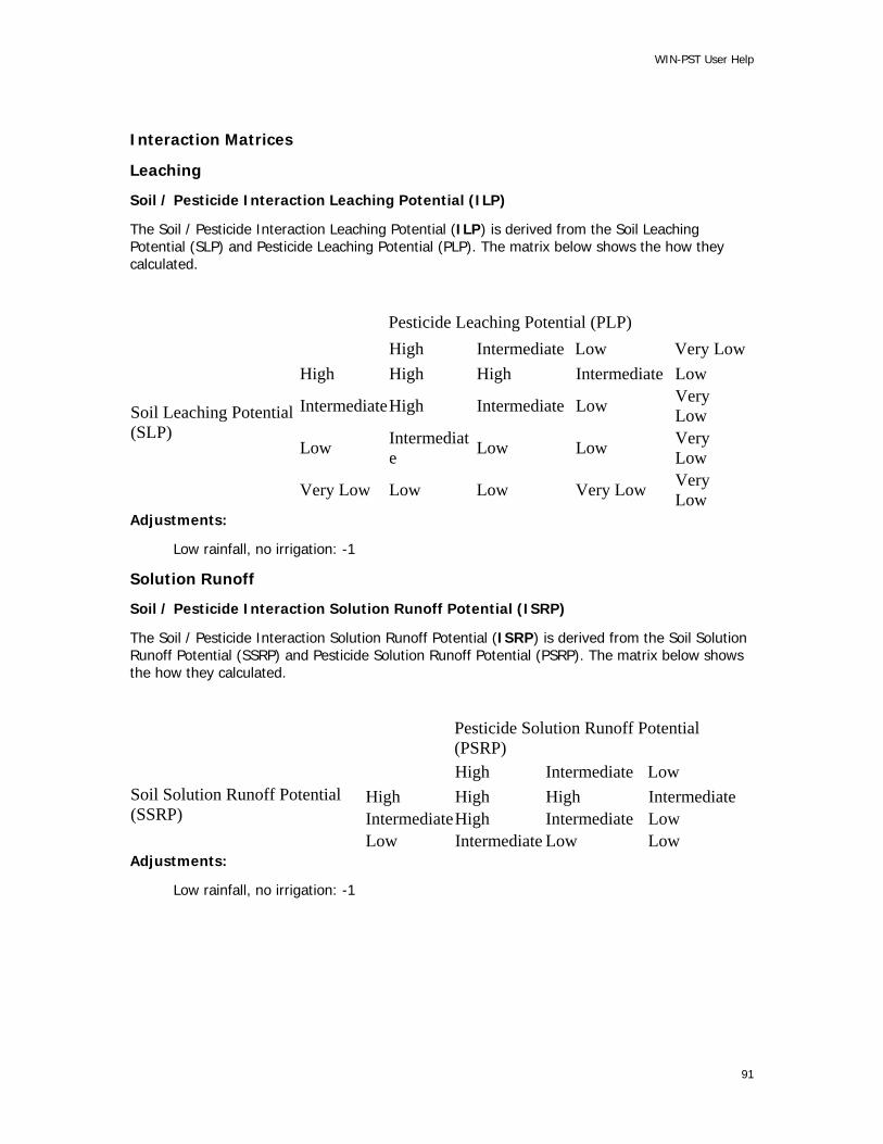
WIN-PST User Help
Interaction Matrices
Leaching
Soil / Pesticide Interaction Leaching Potential (ILP)
The Soil / Pesticide Interaction Leaching Potential (ILP) is derived from the Soil Leaching Potential (SLP) and Pesticide Leaching Potential (PLP). The matrix below shows the how they calculated.
Pesticide Leaching Potential (PLP) High Intermediate Low Very LowHigh High High Intermediate Low
IntermediateHigh Intermediate Low Very Low
Low Intermediate Low Low Very
Low
Soil Leaching Potential (SLP)
Very Low Low Low Very Low Very Low
Adjustments:
Low rainfall, no irrigation: -1
Solution Runoff
Soil / Pesticide Interaction Solution Runoff Potential (ISRP)
The Soil / Pesticide Interaction Solution Runoff Potential (ISRP) is derived from the Soil Solution Runoff Potential (SSRP) and Pesticide Solution Runoff Potential (PSRP). The matrix below shows the how they calculated.
Pesticide Solution Runoff Potential (PSRP)
High Intermediate Low High High High Intermediate IntermediateHigh Intermediate Low
Soil Solution Runoff Potential (SSRP)
Low Intermediate Low Low Adjustments:
Low rainfall, no irrigation: -1
91
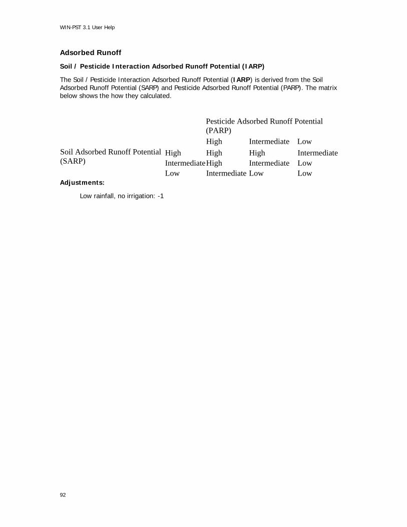
WIN-PST 3.1 User Help
Adsorbed Runoff
Soil / Pesticide Interaction Adsorbed Runoff Potential (IARP)
The Soil / Pesticide Interaction Adsorbed Runoff Potential (IARP) is derived from the Soil Adsorbed Runoff Potential (SARP) and Pesticide Adsorbed Runoff Potential (PARP). The matrix below shows the how they calculated.
Pesticide Adsorbed Runoff Potential (PARP)
High Intermediate Low High High High Intermediate IntermediateHigh Intermediate Low
Soil Adsorbed Runoff Potential (SARP)
Low Intermediate Low Low Adjustments:
Low rainfall, no irrigation: -1
92

WIN-PST User Help
Adjustments
WIN-PST 3.1 adjusts soil, pesticide and interaction ratings based on management and site conditions. Adjustments are as follows:
Soil Ratings
Site Conditions Adjustments:
Leaching:
Macropores: +1 HWT : HIGH
Solution Runoff:
No-adjustments
Adsorbed Runoff:
Field slope > 15%: +1
Pesticide Ratings
Management Adjustments:
Leaching
Foliar: -1
Banded: -1 Spot: -2
Low rate: -1 Ultra Low rate: -2
Solution Runoff
Banded: -1 Spot: -2
Foliar: -1 Soil Incorporated: -1
Low rate: -1 Ultra Low rate: -2
Adsorbed Runoff:
Banded: -1 Spot: -2
Foliar: -1 Soil Incorporated: -1
Low rate: -1 Ultra Low rate: -2
93

WIN-PST 3.1 User Help
Interaction Ratings
Rainfall/Irrigation adjustment:
There is only one adjustment that directly effects interaction ratings and is found on the interactions tab of WIN-PST 3.1. It is the probability of Rainfall or irrigation soon after pesticide application. The selection is labeled “Rainfall” and has two possible choices “Low” or “High”. The default choice is “High”.
Leaching
Low probability of rainfall/no irrigation -1
Solution Runoff
Low probability of rainfall/no irrigation -1
Adsorbed Runoff
Low probability of rainfall/no irrigation -1
Applying the adjustments
The maximum aggregate adjustment allowed is 1 rating class (+/- 1; e.g., “High” gets reduced to an “Intermediate”) for any one pathway (e.g., pesticide leaching) except for “ultra low” application rate and “spot” treatment which decrease pesticide ratings by -2. In other words, adjustments are not additive. Only one adjustment is allowed for any pathway.
For example a pesticide that is both foliar applied (-1) and banded (-1) will only receive a decrease in rating of one class since the ratings are not additive. Therefore, a pesticide leaching potential of “High” would be adjusted to “Intermediate”.
A pesticide that is foliar applied (-1) and spot treated (-2) would receive a two class decrease (-2). This combination of management techniques would reduce a “High” pesticide leaching potential to a “Low”.
Once the Soil Loss Ratings and Pesticide Loss Ratings are adjusted, the interaction matrix (Appendix B) is used to determine the Interaction Loss Rating. The interaction rating can be further adjusted to reflect rainfall or irrigation. If the probability of rainfall or irrigation is very low, then an adjustment factor of one class is applied to the Interaction Loss Rating.
This rating should be used for dry climates/cropping where the pattern of rainfall/irrigation does not occur soon after pesticide application. The definition of “soon after pesticide application” is based on several factors including the half life of the pesticide, formulation and placement of the pesticide (e.g., foliar, soil applied, soil incorporated. etc.). The minimum time for should be at least 10-14 days. For pesticides with moderate to long half-lives (for half life >= 45 days) at least a month of no rainfall or irrigation should be considered before “Rainfall - Low” should be chosen.
If rainfall is typically absent but the field is irrigated, then the adjustment should not be made. For many cropping situations, there will be a probability of rainfall or irrigation soon after application. In these cases the default condition should be used (i.e., Rainfall set to ‘High’).
Hazard Ratings - Adjustment for toxicity
WIN-PST hazard ratings are determined by a matrix created between the Interaction Loss Rating and the Exposure Adjusted Toxicity (EAT) class. The Exposure Adjusted Toxicity class assigns
94

WIN-PST User Help
rating classes to long term toxicity thresholds similar to EPA’s Toxicity class. EAT classes were designed by the WIN-PST group to qualify the potential hazard/risk associated with a potential long-term environmental exposure. EAT classes are broken down by resource concern in the current version of WIN-PST either humans or aquatic. The classes are follows:
Exposure Adjusted Toxicity Ratings for humans.
Class Threshold ranges EXTRA HIGH 1 ppb > X HIGH 10 ppb > X >= 1 ppb INTERMEDIATE 50 ppb > X >= 10 ppb LOW 100 ppb > X >= 50 ppb VERY LOW X >= 100 ppb
Exposure Adjusted Toxicity Ratings, based on STV, for fish.
Class Threshold ranges EXTRA HIGH 10 ppb > X HIGH 100 ppb > X >= 10 ppb INTERMEDIATE 1,500 ppb > X >= 100 ppb LOW 20,000 ppb > X >= 1,500 ppb VERY LOW X >= 20,000 ppb
Calculating the WIN-PST Hazard Potentials
WIN-PST Hazard Potentials are a combination of both the Interaction Loss potential and the Exposure Adjusted Toxicity. See the matrix below:
Hazard Potential Matrix
Exposure Adjusted Toxicity Interaction Loss Rating Extra High High Intermediate Low Very Low High Extra High High Intermediate Low Low Intermediate Extra High High Intermediate Low Very Low Low High Intermediate Low Low Very Low Very Low Intermediate* Low* Very Low* Very Low* Very Low** Leaching only
For example a pesticide/soil interaction loss potential of 'Intermediate' and an Exposure Adjusted Toxicity of 'Extra High', would receive an “Extra High” Hazard rating:
Exposure Adjusted Toxicity Interaction Loss Rating Extra High High Intermediate Low Very Low High Extra High High Intermediate Low Low Intermediate Extra High High Intermediate Low Very Low Low High Intermediate Low Low Very Low Very Low Intermediate* Low* Very Low* Very Low* Very Low*
An Interaction Loss Rating of 'Low' and an Exposure Adjusted Toxicity of 'High' would result in a Hazard rating of “Intermediate”:
95

WIN-PST 3.1 User Help
Exposure Adjusted Toxicity Interaction Loss Rating Extra High High Intermediate Low Very Low High Extra High High Intermediate Low Low Intermediate Extra High High Intermediate Low Very Low Low High Intermediate Low Low Very Low Very Low Intermediate* Low* Very Low* Very Low* Very Low*
96

WIN-PST User Help
Glossary
<ul>
See Ultra Low Rate.
96-hour LC50
Lethal concentration that kills 50% of a fish species' population over a 96-hour (4 Day) period. A type of acute fish toxicity. Stored in ppb in the NAPRA PPD.
AGE
Age of fish tested. A field in the fish toxicity data table.
AI_NAME
Active ingredient common name. A field in the AIS data table in the WIN-PST PPD.
Ai_percent
A field of data in the fish toxicity data table. Indicates the percentage of the product studied which is comprised of this active ingredient.
CNAME_TYPE
Type -- The type of name associated with this active ingredient. (none) -- The preferred name at EPA for this active ingredient. C -- Common Name R -- Chemical abstract service registration number. S -- Synonym T -- Trade Name
COMMENT
Notes we have made in the course of maintaining the toxicity data tables. A field in the fish and human toxicity data tables.
b
See Banded Application.
Banded Application
Pesticide application over less than 50% of the field. This typically involves pesticide application over the rows. Banding pesticide application can reduce the P-Ratings by one class since it reduces pesticide application to the field by 50%. Banded: -1 PLP, -1 PSRP, -1 PARP
Broadcast
Broadcast application (default) - applied to more than 1/2 of the field.
Cancer Slope
See QSTAR.
97
WIN-PST 3.1 User Help
CANCERGRP
EPA Cancer Class (synonymous with EPA Cancer Group). Affects the way an HA* is computed from an RFD. See the definition for HA*. A field in the human toxicity data table. Current EPA Categories (EPA is in the process of revising the Cancer Guidelines) Group A: Human Carcinogen Sufficient evidence in epidemiological studies to support causal association between exposure and cancer.
Group B: Probable Human Carcinogen Limited evidence in epidemiological studies (Group B1) and/or sufficient evidence from animal studies (Group B2).
Group C: Possible Human Carcinogen Limited evidence from animal studies and inadequate or no data in humans.
Group D: Not Classifiable Inadequate or no human and animal evidence of carcinogenicity.
Group E: No Evidence of Carcinogenicity for Humans No evidence of carcinogenicity in at least two adequate animal tests in different species or in adequate epidemiological and animal studies. Reference: "Drinking Water Regulations and Health Advisories" Office of Water, US EPA, Washington, D.C. February 1996
CAS_NO
Chemical Abstract Service Registration Number for an active ingredient. Format: XXXXXXXYYZ. 10 digits, no dashes, with leading zeroes as necessary. Matches the CAS_NO field in the EPA REG DB. CASRN represents the same information as the CAS_NO, except that the format of the digits is different.
CASRN
Chemical Abstract Service Registration Number for an active ingredient. Format: XXXXXXX-YY-Z. 7 digits with no leading zeroes, a dash, then 2 digits with possible leading zeroes, a dash, then 1 digit. This is the most common form of the CAS_NO. CASRN represents the same information as the CAS_NO, except that the format of the digits is different.
98
WIN-PST User Help
CHCL
Chronic Human Carcinogen Level, calculated. The concentration at which there is a 1 in 100,000 probability of contracting cancer; calculated by using the EPA algorithm based on QSTAR from animal studies. A CHCL provides a concentration comparable to an MCL. ---------------------------------------------------------------------------- Algorithm: CHCL = (70 Kg * 10^-5) / (2 L/day * QSTAR) 10^-5 represents a 1/100,000 chance of contracting cancer. 70 Kg represents the average weight of an adult. 2 L/day represents average consumption of water each day by an adult. ---------------------------------------------------------------------------- Reference: "Drinking Water Health Advisory: Pesticides" (Book) United States Environmental Protection Agency Office of Drinking Water Health Advisories Lewis Publishers Pages viii - xiii, 1994
CHEM_ID
WIN-PST PPD active ingredient identification number.
COMP_NAME
Component name. The name of the component (series, taxonomic unit, or miscellaneous area) of the mapunit.
CRACKGR24
Surface Connected Macropores (cracks) at least 24 inches deep. The value can be updated by the user based on the site conditions.
EPA_CNAME_Type
EPA_CNAME_Type is directly taken from EPA's Pesticide Product Information System.
EPA OPP
United States Environmental Protection Agency Office of Pesticide Programs (EPA OPP).
EPA Product Names
A 'product' is a commercially available formulation of one or more active ingredients mixed with adjuvants and inert ingredients. When a pesticide product is sold to the public, it must have an EPA registration number that appears on the product label. An EPA registration number may be associated with many different product names depending on the wholesaler or retailer. The EPA product database used in WIN-PST includes the original registration name for a given product. Since EPA allows manufacturers or dealers to change the name of the product associated with a particular formulation and add new names, some product names for currently registered products will not appear in WIN-PST. Ratings for these products are still available through the EPA registration number. All name differences can be ignored if the EPA registration numbers are identical.
EPA REG DB
EPA Registration Database. Updated monthly.
This database can be accessed online at http://www.epa.gov/opppmsd1/PPISdata/index.html
EXTRA HIGH
See Hazard Ratings.
99

WIN-PST 3.1 User Help
f
See Foliar Application.
FIFRA
Federal Insecticide, Fungicide, and Rodenticide Act (FIFRA)
Fish Hazard
I-ratings combined with fish relative toxicity categories. Only combine the ILP with a fish toxicity when using tile drainage. Only combine the ILP or ISRP with an MATC*. Only combine the IARP with an STV.
See Hazard Ratings for more information.
Fish Toxicity
Toxicity threshold for fish to an active ingredient in parts per billion (ppb). This data is stored in the FISHTOX data table in the TOX_PPB field. See Hazard Ratings for more information.
FOLI_HL_GE
A field in the CHEMICAL data table in the NAPRA PPD. Indicates the quality of the data in the FOLI_HL_RV field.
See G/E.
FOLI_HL_RV
A field in the CHEMICAL data table in the NAPRA PPD. Representative foliar half-life of this pesticide active ingredient, in days, if it is foliarly applied to a crop.
Foliar Application
Foliar pesticide application utilizing a directed spray when the crop and/or weeds are at nearly full canopy. This increases interception of pesticide by the plant and decreases contact with the soil. Foliar application allows reduction of the P-Ratings by one class.
G/E
The G/E fields in the WIN-PST PPD indicate the quality of the representative value. WIN-PST PPD pesticide property data (Koc, solubility in water, and field half-life) is comprised from a variety of sources: -- Pesticide Properties in the Environment; Wauchope et. al., 1996. (PPE) -- Personal communications with Dr. Wauchope. -- EPA OPP "EFGWB One Liner Data Base"; Version 3.04; data table dated 3-18-98. -- Personal communications with chemical companies. ======================================================= All of the values in the WIN-PST PPD were selected from literature with the intent that these values would be used in pesticide models, which requires the use of a 'representative value' rather than a range of values, which more correctly describes the range of values each property could take for each chemical. ======================================================= The values in the G/E field indicate the quality of each data element: G -- A 'Guess' value from PPE and subsequent personal communication with Dr. Wauchope (ARS). Indicates that some degree of uncertainty exists in the value. 'G' is used when no value is known to exist but the authors of PPE believe that the parameter can be estimated by a similar compound. (PPE Pg. 23) i.e. 'G' denotes a 'guess' value -- neither an experimental value nor a good estimation procedure was available. (PPE Pg. 33) Solubilities marked with a 'G' are expected to be accurate within a factor of 10. A total guess was required only for petroleum oil, a mixture of hydrocarbons. (PPE Pg. 9, section 3.3.1)
100

WIN-PST User Help
E -- An 'Estimate' value from PPE and subsequent personal communication with Dr. Wauchope (ARS). Indicates that some degree of uncertainty exists in the value. 'E' is used to indicate that existing data are so diverse that selection of a representative value is a matter of scientific judgement by the authors of PPE or that the value is calculated from some more fundamental property. (PPE Pg. 23) i.e. 'E' denotes that a value is an 'estimate', meaning either: (a) an unusually wide range of values have been reported and we (the authors of PPE) had no reason to select any one value as a 'best' value, or (b) no experimental value is available but a reasonable estimation was possible. (PPE Pg. 33) Solubilities marked with an 'E' are expected to be accurate within a factor of 2. About 10% of the solubilities in PPE were estimated. In some cases, the solubility of a similar compound was used as an estimate. (PPE Pg. 9, section 3.3.1) n -- A 'NAPRA Selected Value'. Equates to a <BLANK>. (These values have not been peer reviewed.) g -- A 'Guess' value developed by the NAPRA Team using Dr. Wauchope's 'Guess' methodology. (These values have not been peer reviewed.) e -- An 'Estimate' value developed by the NAPRA Team using Dr. Wauchope's 'Estimate' methodology. (These values have not been peer reviewed.) <BLANK> -- A value from PPE and subsequent personal communication with Dr. Wauchope (ARS). The set of all pesticides which are not designated by a G, E, n, g, or e.
GT_LT
A field in the fish toxicity data table. Indicates that the actual toxicity is greater than (>) or less than (<) the value listed.
Goss, Don
The author of SPISP. Don W. Goss, Ph.D.
HA
Health Advisory, determined by EPA's Office of Water (OW). The concentration of a chemical in drinking water that is not expected to cause any adverse non-carcinogenic effects over a lifetime exposure with a margin of safety. HA is compared to the PLP or PSRP for humans.
HA*
Health Advisory calculated using the EPA method for calculating HA based on Reference Dose (RFD). RFD values are from the EPA Office of Pesticide Programs (OPP), EPA, or World Health Organization (WHO). The EPA OPP RFD is updated regularly and when available is used to determine HA*. If the RFD from EPA OPP is not available, then the EPA RFD is used. EPA RFD is an agency-wide value that is not updated as regularly or as often as the OPP RFD. If neither of these values are available, then the WHO RFD is used. In accordance with OW policy, Health Advisories are not calculated for chemicals that are known or probable human carcinogens (EPA Cancer Class A and B). ----------------------------------------------------------- Algorithm: -- If the EPA Cancer Class is C: HA* = RFD * 700 -- If the EPA Cancer Class is D, E, or unclassified: HA* = RFD * 7000 -- If EPA Cancer Class is A or B: MCL is used if available from EPA OW. CHCL* is determined in lieu of MCL when MCL is not available. ----------------------------------------------------------------- References: "Drinking Water Regulations and Health Advisories". US EPA Office of Water, 4304. EPA 822-B-96-002. October, 1996. "EPA Office of Pesticide Programs Reference Dose Tracking Report". US EPA Office of Pesticide Programs. February, 1997.
101

WIN-PST 3.1 User Help
Half-Life (HL)
Half-life of an active ingredient under field conditions, in days. Sometimes referred to as field dissipation half-life. Used to compute the P-Ratings. Half-life is the time required for a pesticide to degrade to one-half of its previous concentration. Each successive elapsed half-life will decrease the pesticide concentration by half. For example, a period of two half-lives will reduce a pesticide concentration to one-fourth of the initial amount. Half-life can vary by a factor of three or more from reported values depending on soil moisture, soil pH, temperature, oxygen status, soil microbial population, and other factors. Additionally, resistance to degradation can change as the initial concentration of a chemical decreases. It may take longer to decrease the last one-fourth of a chemical to one-eighth than it took to decrease the initial concentration to one-half. In general, the longer the half-life, the greater the potential for pesticide movement.
Hazard
Pesticide toxicity combined with potential exposure.
HIGH
See Loss Potential Algorithms.
See Interaction Matrices.
See Hazard Ratings.
High Water Table
Water Table is within 24 inches of the soil surface.
See w.
Human Hazard
I-ratings combined with human relative toxicity categories. Combine the ILP or ISRP with an MCL, HA, HA*, or CHCL. IARP cannot be combined with a human toxicity.
Human Toxicity
Long-term human toxicity of an active ingredient in parts per billion (ppb). Toxicities are based on availability in the priority order: MCL, HA, HA* (HA and HA* are used for Cancer Groups C, D, E and unclassified) and CHCL*. MCL is used whenever available by the EPA Office of Water. HA and HA* are used for Cancer Groups C, D, E and unclassified. CHCL* is used for Cancer Groups A, B1 and B2 when MCL is unavailable. This data is stored in the HUMTOX data table in the TOX_PPB field. See Hazard Ratings for more information.
HWT_LT_24
High Water Table less than 24" under the surface. The value comes from the Soils database and can be changed by the user based on the site conditions.
HWT
See High Water Table.
i
See Soil Incorporated.
102

WIN-PST User Help
I-Ratings
SPISP II Soil / Pesticide Loss Interaction Ratings: ILP, ISRP, and IARP. PLP, PSRP and PARP pesticide ratings are combined with SLP, SSRP and SARP soil ratings in a Soil/Pesticide Interaction Matrix that results in ILP, ISRP and IARP Soil/Pesticide Interaction ratings. These interaction ratings provide a relative potential for pesticide loss for each soil/pesticide combination. ILP ratings indicate the potential for pesticides to leach below the root zone. ISRP ratings indicate the potential for pesticides to move beyond the edge of the field dissolved in solution runoff. IARP ratings indicate the potential for pesticides to move beyond the edge of the field adsorbed to sediment and organic matter which is suspended in runoff water. WIN-PST also combines ILP, ISRP and IRP ratings with pesticide toxicity to humans and fish in an Exposure Adjusted Toxicity Interaction Matrix that results in overall Human Hazard and Fish Hazard WIN-PST Ratings. See Interaction Matrices for more information.
IARP
SPISP II Soil / Pesticide Interaction Adsorbed Runoff Potential. See Interaction Matrices for more information.
ILP
SPISP II Soil / Pesticide Interaction Leaching Potential. See Interaction Matrices for more information.
IMPORTDATE
A field in the pesticide toxicity data tables, indicating the date in which the information was imported into the database.
INTERMEDIATE
See Loss Potential Algorithms.
See Interaction Matrices.
See Hazard Ratings.
ISRP
SPISP II Soil / Pesticide Interaction Solution Runoff Potential.
See Interaction Matrices for more information.
Kd
The ratio of sorbed to solution pesticide concentrations after equilibrium of a pesticide in a water / soil slurry. Kd * 100 can be used to approximate unknown Koc's. See Koc.
103

WIN-PST 3.1 User Help
KFACT
Soil Erodibility factor (K). Includes rock fragments. An erodibility factor which is adjusted for the effect of rock fragments. (SSSD User's Manual - Appendix A-11.) Used to compute the SLP and SARP ratings. Valid range: 0.02 - 0.69. Soil Erodibility Factor (K) is the rate of soil loss per rainfall erosion index unit [ton*acre*h(hundreds of acre*ft-ton*in) -1] as measured on a unit plot. The unit plot is 72.6 ft. long, 6 ft. in width, has a 9 percent slope, and is continuously in a clean-tilled fallow condition with tillage performed upslope and downslope. The soil properties that influence assigned K factor values to specific soils are soil texture, organic matter content, structure, and permeability. If the soil hydrologic group is D and KFACT is 0, a KFACT of 0.02, the lowest valid KFACT, is used in the SPISP II Ratings algorithms. A KFACT of 0 is OK in the database if you have a D hydro group because if erosivity is a non-issue, a KFACT was purposely not computed. This is an indication of a field that has virtually no erosion. i.e. A nonerosive soil. For more information on KFACT, see page 8-11 of the USDA Agriculture Handbook # 537 "Predicting Rainfall Erosion Losses -- A guide to conservation planning." December 1978.
Koc
Soil organic carbon sorption coefficient of an active ingredient in mL/g. Used to compute the P-Ratings. Pesticides vary in how tightly they are adsorbed to soil particles. Koc measures the affinity for pesticides to sorb to organic carbon. The higher the Koc value, the stronger the tendency to attach to and move with soil. Soil pH can affect the Koc of ionic and partially ionic pesticides. A pesticide with an anion as the active species would have a Koc set low to account for that pesticide's inability to sorb to soil particles. A cationic active species would tend to bind strongly with soil and therefore have a relatively high Koc. Pesticide Koc values greater than 1,000 indicate strong adsorption to soil. Pesticides with lower Koc values (less than 500) tend to move more with water than adsorbed to sediment. If Koc is not defined, you can compute it from Kd, using one of the following methods: 1) Assuming 1% OM, Koc = Kd * 100 2) Koc = Kd / weight fraction of organic carbon present in the soil, where: Koc = (Cs/Cw) * (1/Foc) = Kd/Foc Cs -- Concentration of pesticide in the soil phase of the slurry. Micrograms pesticide / gram of soil. Cw -- Concentration of pesticide in the water phase. Micrograms pesticide / ml of water. Foc -- weight fraction of organic carbon present in the soil. -- 'Reviews of Environmental Contamination and Toxicology', Volume 123, Wauchope, et. al, 1992, pg 10.
KOC_GE
A field in the WIN-PST PPD. Indicates the quality of the data in the KOC_RV field.
See G/E.
KOC_RV
A field in the WIN-PST PPD. See Koc.
l
See Low Rate.
LC50
See 96-hour LC50.
104
WIN-PST User Help
LOC
Level of Concern. Acute fish toxicity value determined by dividing 96-hour LC50 by two. LOC is used by EPA for risk assessment. ----------------------------------------------------------------- Reference: "Hazard Evaluation Division Standard Evaluation Procedure" 'Ecological Risk Assessment.' EPA-540/9-85-001. Published June, 1986. EPA Office of Pesticide Programs, Washington, DC 20460.
Loss Potential
Potential for pesticide to move off the edge of the field and/or percolate below the root zone. Determined from soil/pesticide interaction ratings (I-Ratings) that result from combining soil ratings and pesticide ratings.
See Loss Potential Algorithms for more information.
LOW
See Loss Potential Algorithms.
See Interaction Matrices.
See Hazard Ratings.
Low Rate
A pesticide application rate of 1/10 to 1/4 lb active ingredient per acre. (112 to 280 grams per hectare.) A low application rate can reduce the P-Ratings by one class.
m
See Macropores.
Macropores
Surface-connected holes or cracks that extend deeper than 24" into the soil. Macropores increase the SLP by one class.
MATC*
Maximum Acceptable Toxicant Concentration (MATC*) in ppb. MATC* is the long-term toxicity value for fish. The MATC* for an active ingredient can be determined empirically by performing long-term or early life-stage toxicity tests. These test results produce the No Observable Effect Concentration (NOEC) and Lowest Observable Toxicant Concentration (LOEC). Empirically, the geometric mean of the NOEC and LOEC is the MATC*. When both the NOEC and the LOEC were available, MATC* was determined in this manner. These values are described as "MATC=geometric mean of (LOEC, NOEC)" in the CALC_NOTES field of the toxicity data browser, TOX_VIEW. When either the NOEC or the LOEC (or both) were unavailable, MATC* was determined from a regression equation using the 96-hour LC50 in the method described by Barnthouse et al., (1990). These values are described as "MATC calc. from 96-h LC50" in the CALC_NOTES field of the toxicity data browser, TOX_VIEW. In rare instances, empirically derived MATC* values were found to be larger than the 96-hour LC50 for that chemical. This may occur when the toxicity tests for the 96-hour LC50 and the NOEC / LOEC are performed: -- Under different water quality conditions. (hardness, alkalinity, pH, temperature, etc.) -- With different species of fish. -- With different products which use this active ingredient (AI). Occasionally, pesticide toxicity can be attributed to the
105
WIN-PST 3.1 User Help
inert ingredients in the formulation of a product which contains this AI, rather than the AI itself. When the empirically-derived (NOEC/LOEC) MATC* is larger than the 96-hour LC50, an MATC* computed using the Barnthouse method is used instead. These values are described as "MATC calc. from 96-h LC50 (since empirically found MATC was > 96-h LC50)" in the CALC_NOTES field of the toxicity data browser, TOX_VIEW. The MATC* for an active ingredient is used in several ways in WIN-PST: -- To compute the WIN-PST Exposure Adjusted Toxicity Rating to fish for pesticide in solution. -- To compute the WIN-PST Exposure Adjusted Toxicity Rating to fish for pesticide adsorbed to sediment. We call this the Sediment Toxicity Value (STV). STV = KOC x MATC* ----------------------------------------------------------------- Reference: Barnthouse, L.W., G.W. Suter II and A.E. Rosen, 1990. "Risks of Toxic Contaminants to Exploited Fish Populations: Influence of Life History, Data Uncertainty and Exploitation Intensity." Environmental Toxicology and Chemistry. 9:297-311.
MCL
EPA's Maximum Contaminant Level. Maximum permissible long-term pesticide concentration allowed in a public water source. MCL is used in WIN-PST for any pesticide for which EPA has an assigned value. In the absence of an MCL, an HA, HA* or CHCL* is used in WIN-PST.
MUSYM
Map unit symbol associated with a soil Map Unit.
n
See G/E.
NAME
Common name of fish species tested. A field in the fish toxicity data table.
NAPRA
National Agricultural Pesticide Risk Analysis.
NAPRA PPD
See WIN-PST PPD.
NPURG
National Pesticide/soils database and User decision support system for Risk assessment of Ground and surface water contamination. Based on the SPISP I algorithms.
OMH / OM_H
The maximum value for the range in organic matter content of the soil layer or horizon, expressed in percent by weight.
OML / OM_L
The minimum value for the range in organic matter content of the soil layer or horizon, expressed in percent by weight.
OPPRFD
EPA's Office of Pesticide Programs Reference Dose. A field in the human toxicity data table.
OW
EPA Office of Water (EPA-OW).
106

WIN-PST User Help
OWRFD
EPA's Office of Water Reference Dose. A field in the human toxicity data table.
P-Ratings
SPISP II Pesticide Loss Ratings: PLP, PSRP, PARP.
See Loss Potential Algorithms for more information.
PARP
Pesticide Adsorbed Runoff Potential. See Loss Potential Algorithms for more information.
PC_CODE
EPA active ingredient registration number. (AKA Shaughnessy Code)
PCT_WASHOF
A field in the NAPRA PPD. This field contains washoff fraction data, if an active ingredient is foliarly applied. This is the fraction of the pesticide applied to the foliage available for washoff.
pH
In general, pH is a numerical measure of acidity or hydrogen ion activity. pH < 7.0 is acidic. pH 7.0 is neutral. pH > 7.0 is alkaline. (basic) In the WIN-PST PPD, pH represents the value at which the solubility in water, field half-life, and Koc (SOL, HL, Koc) are valid. When determining P-Ratings or I-Ratings, appropriate properties are selected based on field soil pH. If the pH field is blank, assume that the SOL, HL, and Koc for this active ingredient are pH-insensitive and therefore that these properties are valid at any soil pH. A pH reading of 5 is ten times more acidic than a reading of 6, and 6 is ten times more acidic than a reading than 7. Most adult fish die in water at a pH of 5 or below.
PHH
The maximum value for the range in soil reaction (pH) for the first soil layer or surface horizon.
PHL
The minimum value for the range in soil reaction (pH) for the first soil layer or surface horizon.
PKA
Acid dissociation constant.
PKB
Base dissociation constant.
PLP
Pesticide Leaching Potential. See Loss Potential Algorithms for more information.
PSRP
Pesticide Solution Runoff Potential. See Loss Potential Algorithms for more information.
107

WIN-PST 3.1 User Help
QSTAR
EPA OPP Cancer Slope Value. Determined from animal studies; QSTAR values are assigned by EPA and used to estimate the probability of contracting cancer from a pesticide. Used to determine CHCL. QSTAR is a field in the human toxicity data table.
RFD
Reference Dose. RFD's based on animal studies are used for human toxicity determination. They are reported by the EPA OW and EPA OPP. A field in the human toxicity data table.
ROCKDEPH
The maximum value for the range in depth to bedrock, expressed in inches.
ROCKDEPL
The minimum value for the range in depth to bedrock, expressed in inches.
s
See Slope.
S-Ratings
SPISP II Soil Vulnerability Ratings: SLP, SSRP, SARP.
See Loss Potential Algorithms for more information.
SARP
Soil Adsorbed Runoff Potential. See Loss Potential Algorithms for more information.
SHRINKSW
Shrink-Swell Potential. An interpretation rating of the soil layer or horizons behavior of changing volume (shrinking and swelling) upon wetting and drying.
Slope
Field slope. If the field slope is greater than 15%, increase the SARP by one class.
SLOPE_H
The upper range of the slope as defined by the USDA-NRCS soils database. This is the value used to set the slope > 15% site condition.
SLOPEGR15
Field slope greater than 15%.
See Slope.
See SLOPE_H.
SLP
Soil Leaching Potential. See Loss Potential Algorithms for more information.
SOIL_HL_GE
A field in the WIN-PST PPD. Indicates the quality of the data in the SOIL_HL_RV field. See GE FIELDS for more information.
See G/E.
108

WIN-PST User Help
SOIL_HL_RV
See Half-Life (HL).
Soil Incorporated
Pesticide incorporated into soil. Incorporation decreases pesticide runoff but increases percolation. Soil Incorporated: +1 PLP, -1 PSRP, -1 PARP.
SOL_GE
A field in the WIN-PST PPD. Indicates the quality of the data in the SOL_RV field. See GE FIELDS for more information.
See G/E.
SOL_RV
A field in the WIN-PST PPD.
See Solubility (SOL).
Solubility (SOL)
Solubility is the measure of an active ingredient's ability to dissolve in water at room temperature. It is expressed in mg/L (ppm). Used to compute P-Ratings. Solubility is a fundamental physical property of a chemical and affects the ease of wash off and leaching through soil. In general, the higher the solubility value, the greater the likelihood for movement.
SOURCE
Source of toxicity data. A field in the toxicity data tables. Fish toxicity data table: Source of toxicity data from which MATC and STV values were calculated. Human toxicity data table: Source of toxicity data: OW -- This toxicity (HA or MCL) is from EPA's Office of Water (EPA-OW). <BLANK> -- HA* and CHCL* from various sources. See definitions for HA* and CHCL.
SPISP II
Soil / Pesticide Interaction Screening Procedure version II.
See Loss Potential Algorithms and Interaction Matrices for more information.
SPISP II Ratings
Soil/PesticideIinteraction Two Ratings. Loss potential algorithms used by WIN-PST 3.1. See Loss Potential Algorithms and Interaction Matrices for more information.
SSRP
Soil Solution Runoff Potential. See Loss Potential Algorithms for more information.
Standard Rate
The default pesticide application rate. A label rate greater than 1/4 lb active ingredient per acre (280 g/ha).
109

WIN-PST 3.1 User Help
STSSAID
State Soil Survey Area ID. Two letter state abbreviation and soil survey area ID (SSAID). A concatenation of FIPS alpha code for a state and the soil survey area symbol (SSAID). Example: MA011, which is the STSSAID for Franklin County, Massachusetts.
STUDY_CAS
CAS_NO reported in toxicity studies for a pesticide. A field in the human and fish toxicity data tables. The STUDY_CAS may differ from the value in the CAS_NO field if the STUDY_CAS was believed to be incorrect.
STUDY_NAME
A field in the pesticide toxicity data tables. Indicates the actual name used in the study from which pesticide toxicity values were procured. Occasionally, the name used in a study does not match the name we would use for that same chemical; based on other identifiers, such as the CAS_NO or the PC_CODE.
STUDY_PC
PC_CODE reported in toxicity studies for a pesticide. A field in the human and fish toxicity data tables. The STUDY_PC may differ from the value in the PC_CODE field if the STUDY_PC was believed to be incorrect.
Study_time
A field in the fish toxicity data table. Indicates the relative timeframe of the study.
STV
Sediment Toxicity Value. STV = MATC x Koc. Compared to the PARP when the species of concern are fish. STV provides toxicity of pesticide sorbed to detached soil leaving the field. Koc is used in STV determination to estimate pesticide concentration in sediment pore water. Fish MATC is used in lieu of toxicity data to sediment dwelling animals for which test data are rare. STV threshold ratings are the same as those used for MATC evaluation. The method for sediment short-term toxicity of nonionic pesticides (Di Torro et al., 1991), was modified to determine long-term toxicity. STV is also used to evaluate ionic pesticide which account for about 25% of pesticides. This is achieved by use of an adjusted Koc in the NAPRA PPD, which accounts for pesticide ionic properties. ---------------------------------------------------- Reference: Di Torro, D.M., C.S. Zarba, D.J. Hansen, W.J. Berry, R.C. Swartz, C.E. Cowan, S.P. Pavlou, H.E. Allen, N.A. Thomas, P.R. Paquin. 1991. "Technical Basis for Establishing Sediment Quality Criteria for Nonionic Organic Chemicals Using Equilibrium Partitioning." Environmental Toxicology and Chemistry. 10:1541-1583
Surface Applied
Surface Applied (default) - applied to the soil surface.
SURFACE DEPTH
Depth of the soil surface horizon. Used to compute the SPISP II SLP rating. This can be a default (Default First Horizon Depth) or user-supplied value (DEPTH[1] (User)). See also: Default First Horizon Depth, DEPTH[1] (User), Horiz[1] / Horiz_1_Depth / H1_DEPTH, LAYDEPH, LAYDEPL, SLP
TAXA
Animal group tested. A field in the fish toxicity data table.
TAXONOMIC
Genus and species of the fish tested. A field in the fish toxicity data table.
110

WIN-PST User Help
TEXTURE
Soil texture class designations. Code for the USDA texture for the specified layer or horizon of the soil. Example: Sandy Loam (SL); Loam (L).
Texture Modifiers Texture Terms Terms used in lieu of texture
BY Bouldery BYV Very bouldery BYX Extremely bouldery CB Cobbly CBA Angular cobbly CBV Very cobbly CBX Extremely cobbly CN Channery CNV Very channery CNX Extremely channery FL Flaggy FLV Very flaggy FLX Extremely flaggy GR Gravelly GRC Coarse gravelly GRF Fine gravelly GRV Very gravelly GRX Extremely gravelly MK Mucky PT Peaty RB Rubbly SR Stratified ST Stony STV Very stony STX Extremely stony
COS Coarse sand S Sand FS Fine sand VFS Very fine sand LCOS Loamy coarse sand LS Loamy sand LFS Loamy fine sand LVFS Loamy very fine sandCOSL Coarse sandy loam SL Sandy loam FSL Fine sandy loam VFSL Very fine sandy loamL Loam SIL Silt loam SI Silt SCL Sandy clay loam CL Clay loam SICL Silty clay loam SC Sandy clay SIC Silty clay C Clay
CE Coprogenous earth CEM Cemented CIND Cinders DE Diotomaceous earth FB Fibric material FRAG Fragmental material G Gravel GYP Gypsiferous material HM Hemic material ICE Ice or frozen soil IND Indurated MARL Marl MPT Mucky-peat MUCK Muck PEAT Peat SG Sand and gravel SP Sapric material UWB Unweathered bedrock VAR Variable WB Weathered bedrock
TOX_PPB
Toxicity threshold concentration of pesticide in parts per billion (ppb).
TOX_TIME
Timeframe associated with a toxicity. WIN-PST PPD, Fish: tox_type: MATC -- LONG-TERM LOC -- 4-DAY WIN-PST PPD, Human: {Lifetime AKA CHRONIC}.
TOX_TYPE
Toxicity type that applies to an animal, fish or humans. FISH: Toxicity types in the WIN-PST fish toxicity data table: 96-hour LC50, LOC, MATC, and STV. HUMAN: Toxicity types in the WIN-PST human toxicity data table: MCL, HA, HA*, and CHCL. Based on availability, usage priority in this database is: MCL, HA, HA* and CHCL. This order was determined by considering: 1. MCL is EPA's drinking water regulation of choice. 2. HA has been determined by the EPA Office of Water (OW). 3. HA* is calculated by the same method used by the OW for noncarcinogens and possible human carcinogens as determined by OW. 4. CHCL is determined for probable and known carcinogens. It is comparable to the MCL.
111

WIN-PST 3.1 User Help
Ultra Low Rate
A pesticide application rate of 1/10 lb or less active ingredient per acre. (112 grams per hectare.) An ultra low rate of application allows reduction of the P-Ratings by two classes.
USEPARFD
United States EPA assigned Reference Dose.
Usepattern
A field of data in the fish toxicity data table.
USER_OM
A value that represents percent organic matter in the first soil horizon. The value comes from the Soils database and can be changed by the user based on the site conditions.
VERY LOW
See Loss Potential Algorithms.
See Interaction Matrices.
See Hazard Ratings.
VP_GE
A field in the WIN-PST PPD. Indicates the quality of the data in the VP_MMHG field. See GE FIELDS for more information.
See G/E.
VP_MMHG
A field in the WIN-PST PPD. Vapor pressure in millimeters (mm) of mercury (Hg).
VP_PH
A field in the WIN-PST PPD. The pH at which the value in the VP_MMHG field is valid.
w
See High Water Table (HWT)
WHO
World Health Organization.
WHORFD
World Health Organization Reference Dose. RFD's from WHO are used to calculate HA* when RFD's are unavailable from EPA OPP or EPA. A field in the human toxicity data table.
WIN-PST PPD
WIN-PST / NAPRA Pesticide Properties Database (PPD). Comprised of data from a variety of sources, this database contains EPA registration data (EPA REG DB), representative value pesticide property data (source indicated by the G/E field in the data tables), and toxicity data for humans and fish.
WTDEPL
Lower range of the depth to high water table, in feet. If the depth to the high water table comes within 2 feet of the soil surface during the growing season, then the HWT_LT_24 soil site condition should checked.
112

WIN-PST User Help
WTKIND
Kind of water table: Apparent, perched, or artesian.
USER_DEPTH
A value that represents the Depth of the soil surface horizon. The value comes from the Soils database and can be changed by the user based on the site conditions.
113