wireless location technologies nobuo kawaguchi graduate school of eng. nagoya university
TRANSCRIPT

Wireless Location Technologies
Nobuo Kawaguchi
Graduate School of Eng.Nagoya University

Today’s Topic
Wireless Location Technologies What is WiFi based Positioning HistoryCharacteristics
WiFi Location Database Wireless Location Information Systems
PlaceLab Skyhook Wireless Loki PlaceEngine Locky.jp Apple iPhone
Location Enhanced Services

1m 10m 100m
Estimation Accuracy
Env
iron
men
t
PHS
GPS
Outdoors
Indoors
CellPhone
Ultra Sonic RFID
UWB
Wireless LAN
Wireless Location Technologies Tech. for both Indoor / Outdoor is required
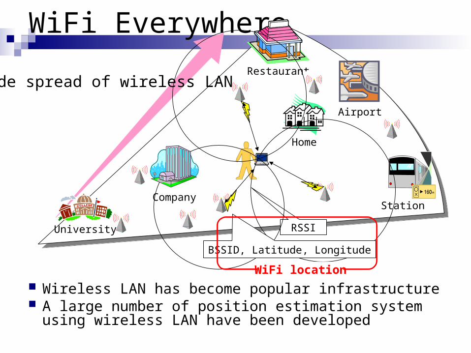
WiFi Everywhere
Wireless LAN has become popular infrastructure A large number of position estimation system
using wireless LAN have been developed
Station
Home
Restaurant
Airport
Wide spread of wireless LAN
RSSI
BSSID, Latitude, Longitude
University
Company
WiFi location

WiFi Location Technology Every WiFi Access Point(AP) has followings
ESSID (String) BSSID 6 byte vendor assigned unique address
(MAC) Construct a database with BSSID and Position
One can estimate the position just receive a WiFi BSSID.
A lot of WiFi APs are already exist in the Wild.
One can easily add new APs by oneself. Can increase accuracy by adding APs. Each AP do not requires network access for positioning.
Important Points

now
2000:RADAR(Microsoft)
2000:Ekahau
2005/7:Locky.jp(Nagoya Univ)
2006/7:PlaceEngine(Sony CSL)
History of WLAN positioning
Start around 2000 (MS RADER)
2006/3:Loki(Skyhook Wireless)
2003:AirLocation(Hitachi)
2003:PlaceLab(Intel)
Service/Activities
Products
Technology
2007/9:Digial Camera(Sony)
2008/1:iPhone (Apple)

Triangulation Lateration (RSSI or TDOA)
RADAR (MS Research), WiPS (Kyusyu Univ. Japan)
AirLocation (TDOA)(Hitachi) Angulation (AOA)
Proximity GUIDE Project (Keith et al)
Scene Analysis RADAR(MS Research), Ekahau (Ekahau corp.) Place Lab (Intel Research)
Existing methods are classified into following three types.
Positioning methods using WLAN

Positioning Access Point
Triangulation
Using more than 3 reference point’s distance
Using more than 2 reference points direction
AB
C
a b
c
E
AB
E
α
β
(Lateration)(Angulation)
Reference PointEstimated Point
Reference Direction

Positioning Access Point Proximity
Consider the position of most powerful APas a current position.
Transmission range of Wireless LAN is about 100 meters in the open air
Not good accuracy but simple.
Scene Analysis Consider Difficult to construct learning data as target area is
spread Inappropriate for our objective

Terminal’s location
APn(xn,yn)
AP2(x2,y2)Reference Point
AP1(x1,y1)
Communication Area of Reference Point
This method consider communication area of AP as user’s position.
Proximity
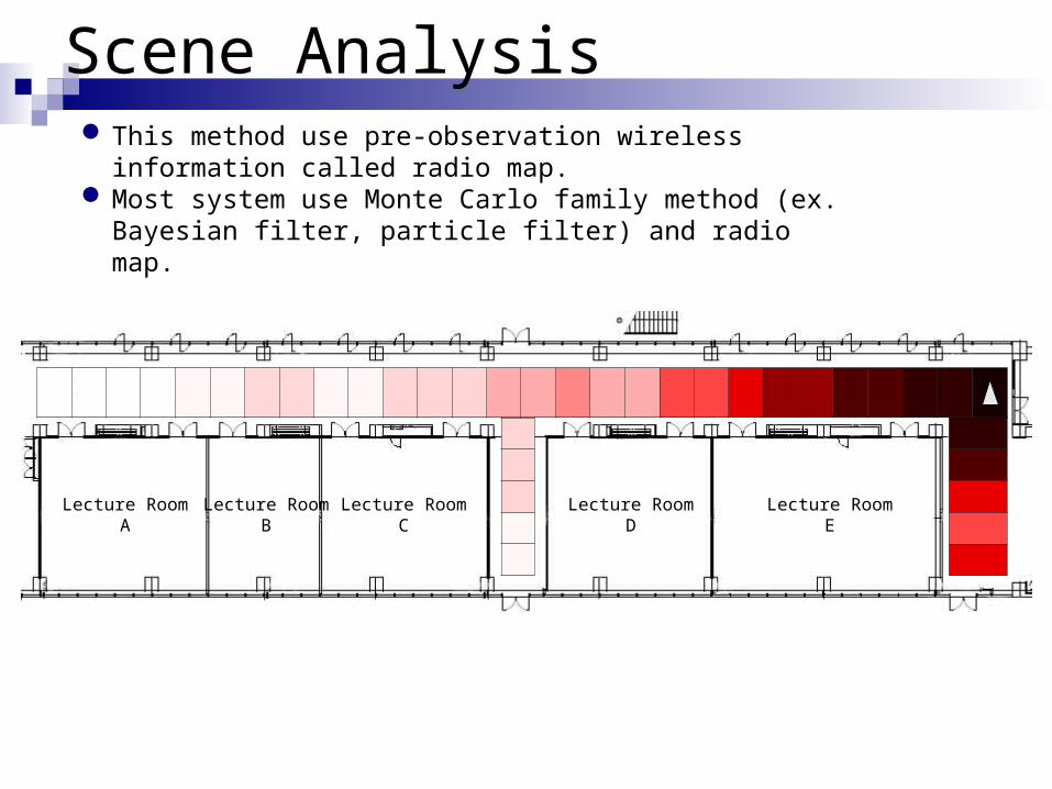
Lecture RoomA
Lecture RoomB
Lecture RoomC
Lecture RoomD
Lecture RoomE
This method use pre-observation wireless information called radio map.
Most system use Monte Carlo family method (ex. Bayesian filter, particle filter) and radio map.
Scene Analysis

GPS vs WiFi Location
From , Delivering Real-World Ubiquitous Location Systems, C. ACM 2006.

WiFi Location: Characteristics
WiFi characteristicsDifference of WLAN Adapter/AntennasDifference on OrientationWiFi Signal Strength Distribtion
WiFi Positioning AcitivitiesLocky.jp Project
WiFi AP positioning

Difference on WLAN Adapter

Wireless LAN Adapter B
Wireless LAN Adapter A
Distribution Difference

0º
45º315º
225º 135º
90º270º
180º
Wireless LAN Card A
Wireless LAN Card B
Wireless LAN Card C
Difference on Orientation

Received Signal Strength (dBm)
Prob
abil
ity
Den
sity
0
0.05
0.1
0.15
0.2
0.25
-60 -55 -50 -45 -40
Distribution Pattern of WiFi RSSI

WiFi Location Database
Required for wide area location system. Acquisition Method
AccuracyEfficiency
How to construct a large DatabaseLocky.jp

Acquisition Methods Variety of acquisition methods with different transportation
Car30km/h
Bicycle15km/h
Walking5km/h
Near to the buildings and houses
Influenced by traffic jams and regulations

20%
30%
40%
50%
60%
70%
80%
90%
100%
Learning Data ( Walking )Learning Data ( Bicycle )Learning Data ( Car )
Estimation Accuracy
The position estimation using the learning data acquired by walking can make estimates at less than 30m in 63% of the area
The estimation data by car is worse by about 5% in all ranges Beyond 40 m, the bicycle data can estimate almost as well as that
obtained by walking
Cumulative estimation accuracy of evaluative data by walkingAccuracy(m)
Cum
ulat
ive
rate

0
0.1
0.2
0.3
0.4 Car
Motor Bike
Bicycle
0-20 21-40 41-60 61-80 81-100 101- unknown
Pro
babi
lity
Den
sity
Accuracy (m)
Car
Motor Bike
Bicycle
Accuracy of WiFi location

Result: Bicycle is more suitable than Others
Bicycle has better efficiency than others
Walking
(5km/h)
Bicycle
(15km/h)
Car
(30km/h)
All data
No. of APs 247 269 183
Accuracy (m) 24.3 26.7 29.6
Coverage (%)
86.8 87.8 83.3
First-round data
No. of APs 214 209 122
Accuracy (m) 31.3 23.2 26.0
Coverage (%)
72.2 74.6 68.2
Strong signal APs
(1st round) (RSSI > -90)
No. of APs 155 178 49
Accuracy (m) 30.1 23.5 32.9
Coverage (%) 68.1 73.2 53.8
Table: Position Estimation of Experimental data ( Walking, Proximity )

GPS
Note PC
WiFi Antenna / Card
Battery
Stumbler
WarDriving using bycicle

Locky.jp Project

Locky.jp Project
WiFi Location Portal for JapanData Collection of WiFi AP(BSSID) + LocationPlace Information
Begins July 2005
Currently, we have collected
369,045 APs currently

Locky.jp
Goals of Locky.jp Wide-area WiFi Location acquisition by collaboration with user Creation of position estimation system using WiFi Location database Producing Low-Cost positioning system for everywhere everybody
Activity Research on positioning system Public relations of positioning system Creation of acquisition assistance tools
Locky.jp
Environment full of wireless LAN
Users
WiFi LocationDatabase
Information Service
WiFi Location
Effect on …Service areaEstimation accuracy
WiFi LocationWiFi LocationWiFi Location

Collecting AP’s by Collaborators
300 over members collecting AP
Mainly for Tokyo/Osaka/Nagoya - Ranking

Trend of No. of AP in Locky.jp
Over 530,000 WiFi locations in Japan
0
50000
100000
150000
200000
250000
Oct-05
Nov-05
Dec-05
J an-06
Feb-06
Mar-06
Apr-06
May-06
J un-06
J ul-06
Aug-06
Sep-06
0
20
40
60
80
100
120
WiFiUser
Month
No. of collaboratorNo. of AP
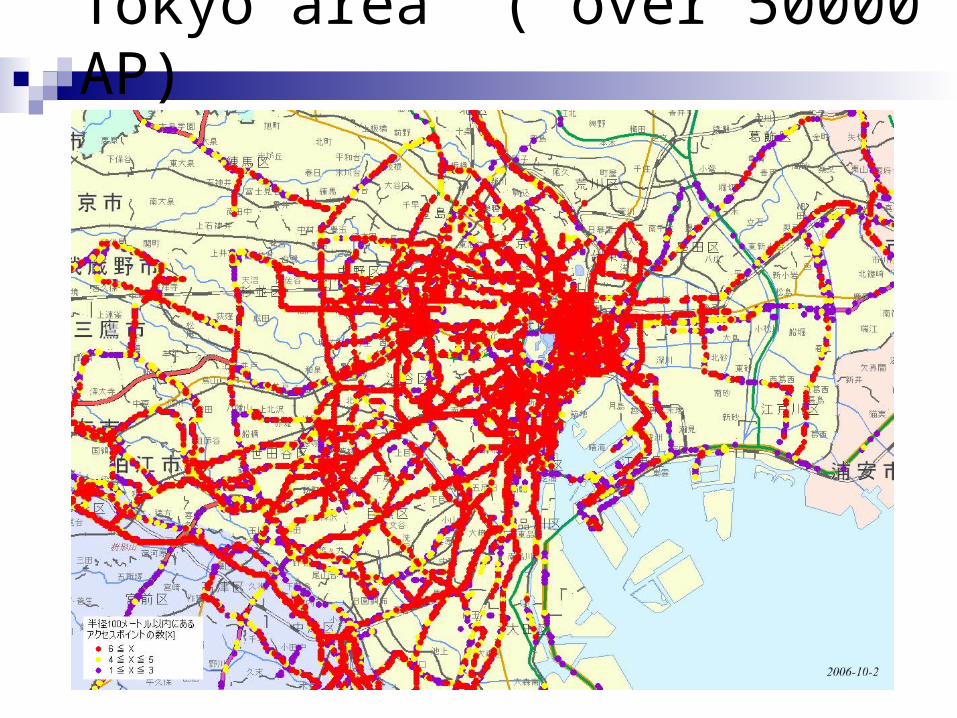
Tokyo area ( over 50000 AP)

Tokyo APs plotted on GoogleEarth

View from Tokyo-Castle

Nagoya Area , Over 40000APs

Access Point
Total 8788.8 unit / 100m×100m
1km
Access Points in Nagoya City Area
1km Square878 APs
Center of NagoyaJAPAN
Access Point
Total 2783.5 unit /100m×100m
Residential Area
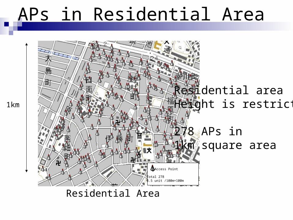
APs in Residential Area
1km
Residential areaHeight is restricted
278 APs in 1km square area

Locky.jp upload page

Tools for Locky.jp
Locky Stumbler
KML converterLog→ KML (Google Earth)

Wireless Location Lib for WLDB
Locky ToolkitBy using Locky Toolkit, one can easily
develop a WiFi Location ApplicationJust a few line of Java code.
// Creation of LockyToolkit objectLockyToolkit lockyToolkit = new LockyToolkit();
// Load a WiFi Location DBlockyToolkit.openDB();
// Get Locky Code from current wireless measurementLockyCode lockyCode = lockyToolkit.getLockyCode();
// Get latitide, Longitudedouble latitude = lockyCode.getLatitude();double longitude = lockyCode.getLongitude();
Locky Toolkit example program ( Java )

Bootstrapping Location-enhanced ComputingEnabling privacy-observant, wide scale, indoor & outdoor device positioning with low barriers to participation
Research Agenda• Previous research: small communities, high cost systems
• Our goal: enable large communities by reducing barriers to adoption
• Provide low-cost, highly convenient position-sensing technology
• Make users comfortable with respect to their location privacy
• Develop services and toolkits to make it easy to build location-aware applicationsUsage Model
Client devices cache snapshots of WiFi Beacon Databases
Applications use location to provide customized, dynamic
content and services
Devices that hear WiFi beacons estimate location locally & privately.
New beacons get added to user-contributed database
Urban areas have dense WiFi coverage
PlaceLab Approach • Rely on increasing WiFi densities to provide low-cost device positioning
• Build a public user-contributed data store to map RF beacons to geographic locations
• Improve quality of positioning data via Bayesian filter and sensor fusion techniques
• Understand privacy management tradeoffs by studying use of location-aware applications
• Provide a “PlaceLab” for educators with toolkits and curriculum for web and ubicomp courses
• Offer developers a mechanism to use “place” abstractions in addition to low-level coordinates(Reference http://www.placelab.org/ )
PlaceLab (2003 ~ Intel Research)

Skyhook wireless
Loki
200 employee
8million APs
http://loki.com/
Loki Toolbar
By using the Loki toolbar, one can locate the place of the terminal in major cities in U.S.


PlaceEngine by Sony CSL
You can upload theWiFi Info to PlaceEngine Serverusing Web Service

(Reference http://www.placeengine.com/ )
PlaceEngine
Web service for WLAN location 200,000 access point in Tokyo area.

(Reference http://www.placeengine.com/ )
PlaceEngine 150,000 access point in Tokyo area.

Mash up with PlaceEngine
PlaceEngine can be used as a Web parts.
PlaceEngine Client
Web Browser
PlaceEngineWeb DB
Web Service
PE button
Your PC

PlaceEngine×Station Info.
PlaceEngine can be used as a Web parts.

PlaceEngine × Restaurant Search

PlaceEngine × Restaurant Search
Asked to send “location” to Web Application

PlaceEngine × Restaurant Search

Apple iPhone
Apple iPhone utilize WiFi Positioning System by Skyhook Wirelessand GSM Location System by Google.

Google Maps for Mobile
"My Location" Technology
http://www.google.com/intl/en/press/annc/20071128_maps_mobile_my_location.html
Adds a GSM Location technology ontomobile phones
Do not require GPS (only 15% of mobile phone has GPS)

Community:
War Driving Communityhttp://wigle.net
12,886,129 points from 796,376,798 person
(2008/01/23)
Mostly for use WiFi Hotspot.Not for positioning.


Applications of WLAN Positioning
Beacon Print (Intel Research: UbiComp2005)Detect User’s Preferred PlacesDo not require pre-acquisition
NearMe (MS Research:UbiComp2004)Wireless Proximity
Detect near person using BSSID
Self organization of WLAN AP dataPlaceEngine uses this technology

WiFi Tagged Photo Exif for JPEG
Date , Time , other photo data add WiFi BSSID.. ||Location Enhanced Photo
If you put photos on Flickr with BSSID, You can find the closer photos.With WiFi tag, and WiFi Location DB,
You can find the photo using Place.
This does not require offline WiFi location database
Digital camera with WiFi is now on Market

Utilization of WiFi Location System
Location systems are widely spreadBut not for WiFi Location System
GPS is primary location sourceA lot of GPS application are public
NMEA format
We need integrate WLS with GPS

Implementation of Virtual GPS
Virtual COM driverGPS Application
Get NMEA data from COM port
Virtual COM Driver
Locky VirtualGPS
WiFi
WLDB
COM X COM Y
NMEAoutput

Hybrid Positioning with GPS
Virtual COM driverGPS Application
Get NMEA data from COM port
Virtual COM Driver
Locky VirtualGPS
WiFi
WLDB
COM X COM Y
NMEAoutput
GPS
Selection module

Indoor positioning for public area
Outdoors data can be easily collected Locky.jp tool (GPS+ WiFi)
How to collect data for indoor area.There is no way to locate position.We need some tool for data acquisition.
Which place we should collect?Public place with WiFi

Subway of Nagoya

We have WiFi on all stations

We collected underground WiFi
Map of undergroundUse a photo of floor map.
Plot a location by Hand on the photo.Any place can be collected with this tool.Other data can be offered with Photo.

Subway Stumbler
We have developed a tool for indoors

How many data have we collected?
Current Subway WiFi data.83 Nagoya Subway Stations 30 person-day2000 Unique APs82500 point of locations

How many data have we collected?
Current Subway WiFi data.83 Nagoya Subway Stations 30 day collection2000 Unique APs82500 point of locations
Only 30 day are required to collect subway data in Nagoya ( 2 million city )

Location Processing
Subway knowledgeTime table
Arrival time can be estimate
There are shops in the station.RestroomsExchange station
It is not only a location information

Possible Applications
Train Navigation with “Time”
Exit navigation
If you collect WiFi data every seconds,Your route is stored in the device.Station/Route can be estimated.
→ Train fee is easily calculated.

Underground Map of Nagoya
ALPSLAB Underground(Since 2007/12)

We already collected WiFi
Total Unique Sakae Area AP = 160 Nagoya Station AP : 241

Experiment with iPod Touch

Writing Enquate

FriendMap
Shows the position of Friends and Chat

iNavi
Location Dependent Database
Input Query Result set Infomation

NextTrain
Realtime TimeTable
Station Map Countdown for next train

Realtime Train Map
Shows position of trains by time-table
Shows current position Trace the train

Station Map
Maps for underground station

U Underground Map
Summary
Wireless Location TechnologyWith WiFi, one can easily estimate one’s
position Collection of WiFi Location Database
Locky.jp
Experiment in Real In-door EnvironmentNagoya Subway