wireless sensor network for detecting disasters - … maneesha... · wireless sensor network for...
TRANSCRIPT

Wireless Sensor
Network for Detecting
Disasters
AUM AMRITESWARYAI NAMAH
Dr. Maneesha Ramesh,Director & Professor
Amrita Cenetr for Wireless Networks and Applications,Amrita Vishwa Vidyapeetham
CANEUS SSTDM 2014
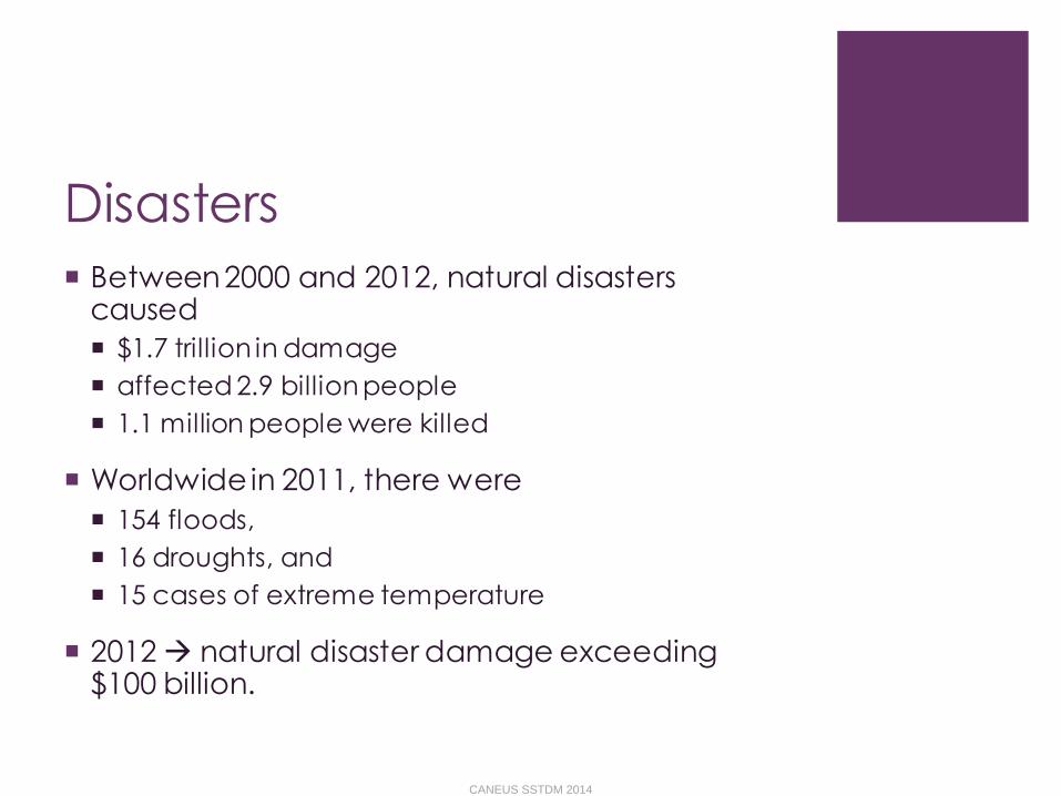
Disasters
Between 2000 and 2012, natural disasters caused
$1.7 trillion in damage
affected 2.9 billion people
1.1 million people were killed
Worldwide in 2011, there were
154 floods,
16 droughts, and
15 cases of extreme temperature
2012 natural disaster damage exceeding $100 billion.
CANEUS SSTDM 2014

Disasters Floods
the most widespread natural disaster
Earthquakes:
cause associated destruction of man-made structures
instigate other natural disasters such as tsunamis, avalanches, and landslides
Hurricanes
coupled with storm surges and sever flooding
Landslides
often accompany earthquakes, floods, storm surges, hurricanes, wildfires, or volcanic activity
often damaging and deadly than the triggering event
CANEUS SSTDM 2014
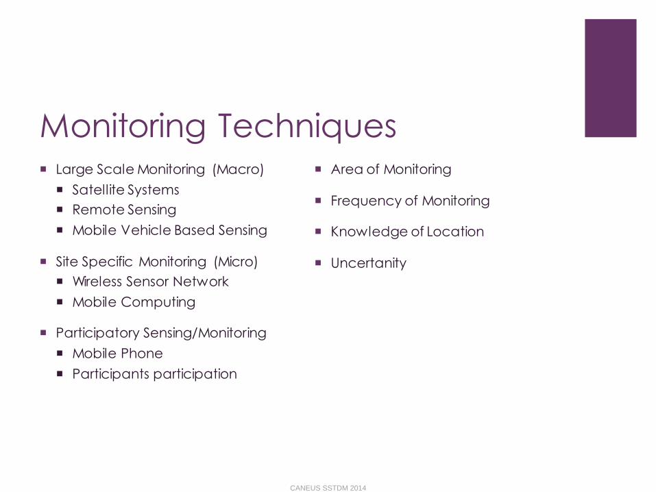
Monitoring Techniques Large Scale Monitoring (Macro)
Satellite Systems
Remote Sensing
Mobile Vehicle Based Sensing
Site Specific Monitoring (Micro)
Wireless Sensor Network
Mobile Computing
Participatory Sensing/Monitoring
Mobile Phone
Participants participation
Area of Monitoring
Frequency of Monitoring
Knowledge of Location
Uncertanity
CANEUS SSTDM 2014

Disasters Vs. Parameters
Disasters Landslide
Flood
Drought
Hurricane
Storms
Avalanche
Forest Fire
Earthquake
Parameters Rainfall
Moisture
Water Level
Wind
Movement
Temperature
Humidity
Vibration
CANEUS SSTDM 2014

Requirements for Monitoring
Sub Systems Sensors
Data Collection Techniques
Data Aggregation Techniques
Real-time Communication Technology
Complex Data Analysis
Multiple methods for detection
Alert Dissemination
Required Functionalities
Long Term Monitoring
Network Lifetime Extension
Fault Tolerant
Communication
Technology
Heterogeneous Data
Aggregation, Analysis
Multi-path for Alert
Dissemination
CANEUS SSTDM 2014

Major disasters instigate
other multiple types of disasters
CANEUS SSTDM 2014
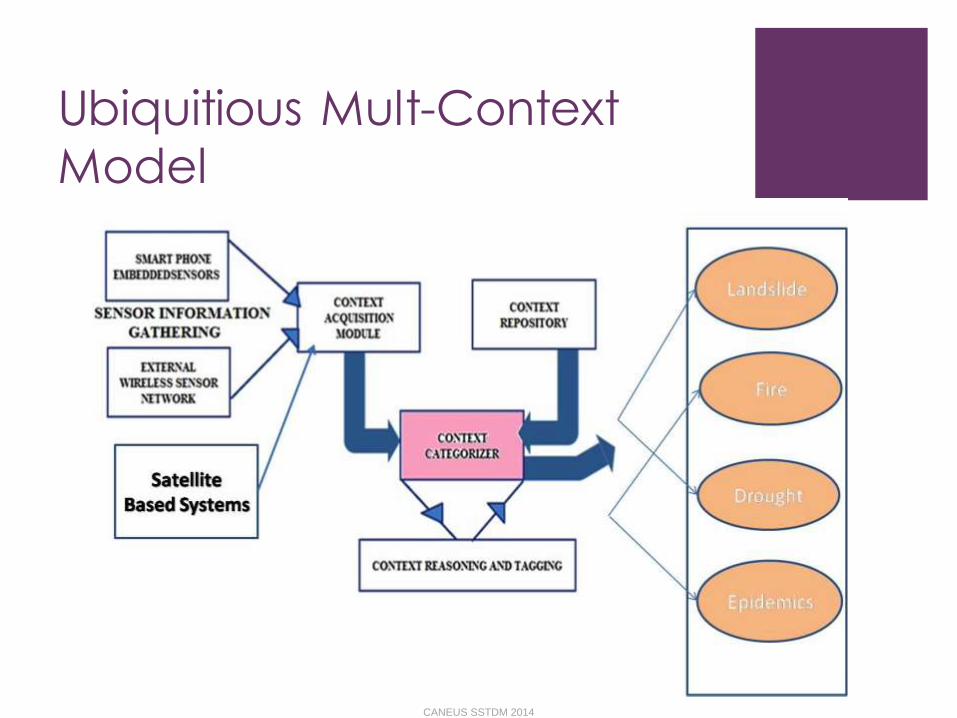
Ubiquitious Mult-Context
Model
CANEUS SSTDM 2014
Wireless Sensor Network for
Monitoring and Detection
of Landslides
Amrita University
CANEUS SSTDM 2014
Introduction
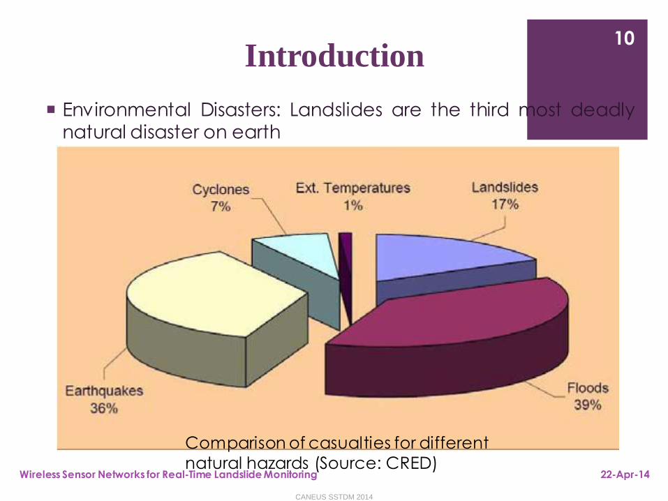
Environmental Disasters: Landslides are the third most deadlynatural disaster on earth
22-Apr-14Wireless Sensor Networks for Real-Time Landslide Monitoring
10
Comparison of casualties for different
natural hazards (Source: CRED)
CANEUS SSTDM 2014
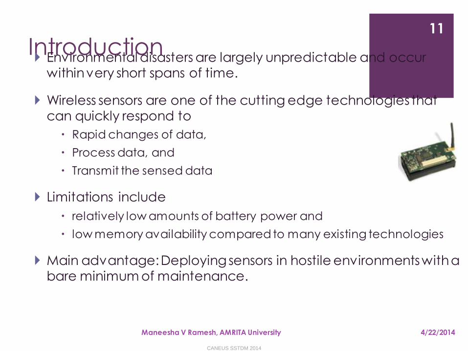
Introduction Environmental disasters are largely unpredictable and occur
within very short spans of time.
Wireless sensors are one of the cutting edge technologies that can quickly respond to
Rapid changes of data,
Process data, and
Transmit the sensed data
Limitations include
relatively low amounts of battery power and
low memory availability compared to many existing technologies
Main advantage: Deploying sensors in hostile environments with a bare minimum of maintenance.
4/22/2014Maneesha V Ramesh, AMRITA University
11
CANEUS SSTDM 2014
Major Outcomes
“World’s first ever comprehensive wireless sensor network for landslide detection”-AMRITA wireless sensor network for landslide detection
“India’s first ever landslide laboratory set up for landslide detection”-AMRITA landslide laboratory set up for landslide detection
4/22/2014Maneesha V Ramesh, AMRITA University
12
CANEUS SSTDM 2014

Landslides
• The rapid down-slope movement of soil, rock and
organic materials under the influence of gravity.
• Short-lived and suddenly occurring phenomena
• Causes extraordinary landscape changes and
• destruction of life and property
• In India,
• Landslides mainly happen due to the heavy rainfall.
• Annual loss due to landslides equivalent to $400 million
This study concentrates on rainfall induced landslides
4/22/2014Maneesha V Ramesh, AMRITA University
13
CANEUS SSTDM 2014
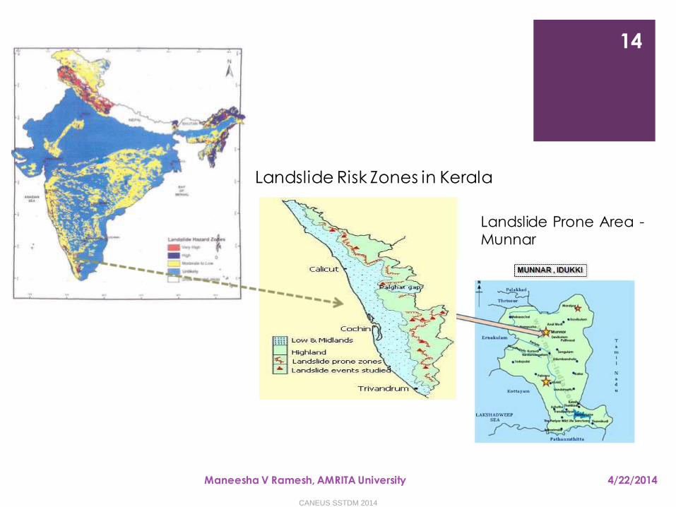
Landslide Risk Zones in India
4/22/2014Maneesha V Ramesh, AMRITA University
14
Landslide Risk Zones in Kerala
Landslide Prone Area -Munnar
CANEUS SSTDM 2014
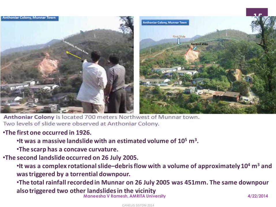
Landslide Site Selection
4/22/2014Maneesha V Ramesh, AMRITA University
15
•The first one occurred in 1926. •It was a massive landslide with an estimated volume of 105 m3. •The scarp has a concave curvature.
•The second landslide occurred on 26 July 2005. •It was a complex rotational slide–debris flow with a volume of approximately 104 m3 and was triggered by a torrential downpour. •The total rainfall recorded in Munnar on 26 July 2005 was 451mm. The same downpour also triggered two other landslides in the vicinity
CANEUS SSTDM 2014
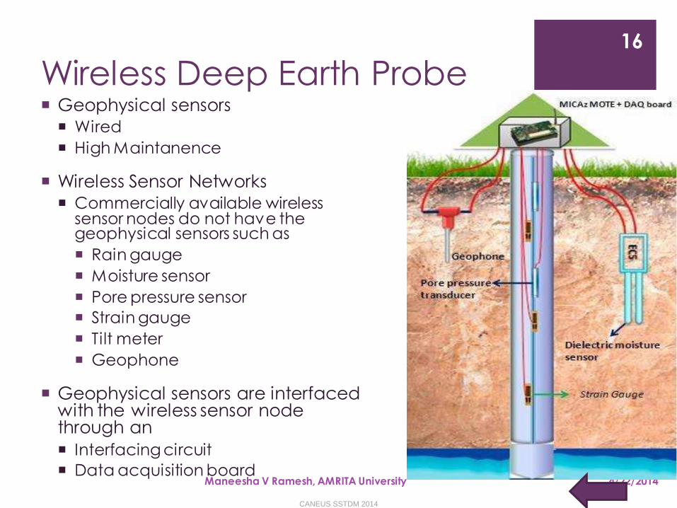
Wireless Deep Earth Probe
4/22/2014Maneesha V Ramesh, AMRITA University
16
Geophysical sensors
Wired
High Maintanence
Wireless Sensor Networks
Commercially available wireless sensor nodes do not have the geophysical sensors such as
Rain gauge
Moisture sensor
Pore pressure sensor
Strain gauge
Tilt meter
Geophone
Geophysical sensors are interfaced with the wireless sensor node through an
Interfacing circuit
Data acquisition board
CANEUS SSTDM 2014

Locations of the Deep Earth Probes (DEPs) and Rain Gauge (RG)
CANEUS SSTDM 2014
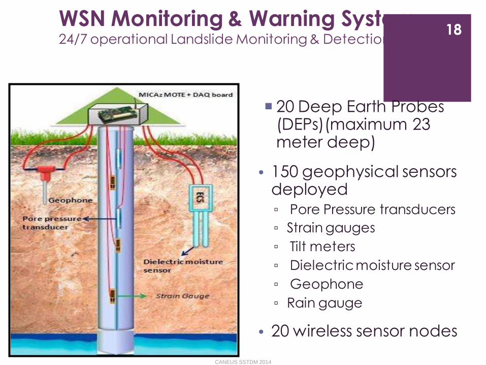
WSN Monitoring & Warning System24/7 operational Landslide Monitoring & Detection WSN
20 Deep Earth Probes (DEPs)(maximum 23 meter deep)
• 150 geophysical sensors deployed▫ Pore Pressure transducers
▫ Strain gauges
▫ Tilt meters
▫ Dielectric moisture sensor
▫ Geophone
▫ Rain gauge
• 20 wireless sensor nodes
18
CANEUS SSTDM 2014
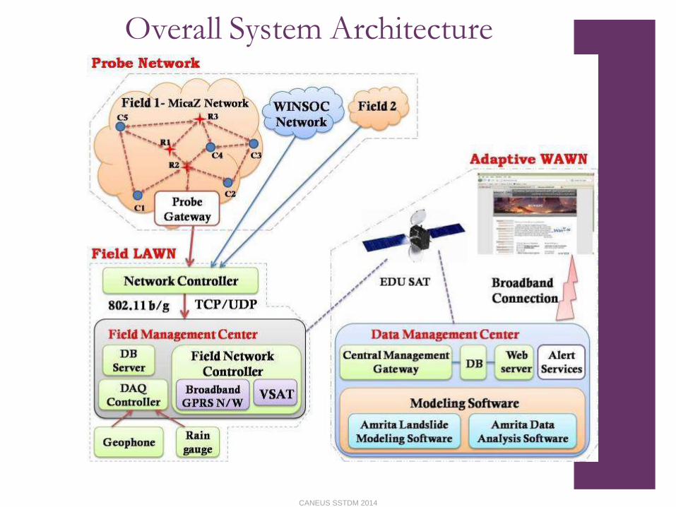
Overall System Architecture
CANEUS SSTDM 2014
Warning system Real-time Data Analysis - Three Level Warning System
Warning 1: Threshold level of rain gauge & dielectric moisture sensor
Warning 2: Threshold level of pore pressure transducer
Warning 3: Detection of movement initiation
Landslide Modeling Software
Landslide Laboratory Setup
6/19/2009Maneesha V Ramesh
20
CANEUS SSTDM 2014
Design of Feedback System
Remote administering,
the sampling rate of the geological sensors
with respect to real-time climatic variations,
monitor the level of battery charges,
monitor the level of solar charging rate,
indicate faulty wireless sensor nodes or geological sensors etc.
4/22/2014Maneesha V Ramesh, AMRITA University
21
CANEUS SSTDM 2014
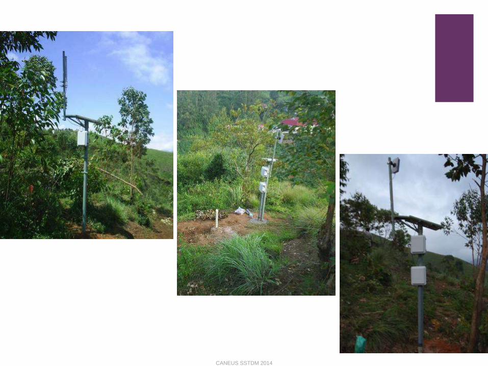
Current Deployment
CANEUS SSTDM 2014
6/19/2009Maneesha V Ramesh
23
CANEUS SSTDM 2014

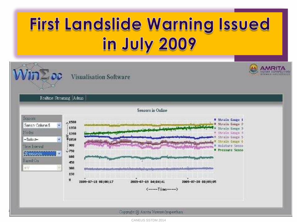
Landslide Warning Issued
4/22/2014
24
CANEUS SSTDM 2014

Landslide Warning Issued
July 21, 2009
Heavy rain fall
Increase in pore pressure
Slight movements
Rainfall threshold exceeded with respect to Caine (1980)
4/22/2014
25
39.082.14 DI
CANEUS SSTDM 2014

Landslide laboratory
set up
4/22/2014
Maneesha V Ramesh 26
CANEUS SSTDM 2014
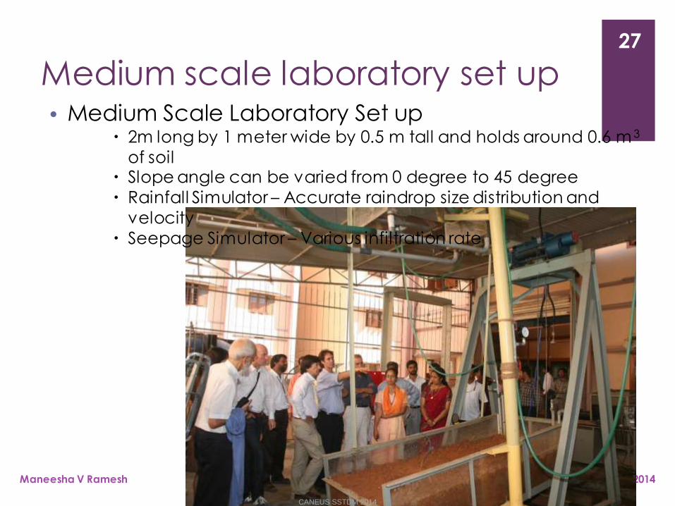
Medium scale laboratory set up
4/22/2014Maneesha V Ramesh
27
• Medium Scale Laboratory Set up 2m long by 1 meter wide by 0.5 m tall and holds around 0.6 m 3
of soil Slope angle can be varied from 0 degree to 45 degree
Rainfall Simulator – Accurate raindrop size distribution and
velocity
Seepage Simulator – Various infiltration rate
CANEUS SSTDM 2014

Large scale landslide laboratory set
up
4/22/2014Maneesha V
Ramesh
28
• 4.6 m long by 2.6 m wide by 2 m tall
• designed to hold approximately 12 m3 of soil.
• up to 24 tone's of soil can be tested, at a maximum depth of up to 4
feet
• Slope angle can be varied from 0 degree to 45 degree• Rainfall Simulator - Accurate raindrop size distribution
• Seepage Simulator - Various infiltration rate
CANEUS SSTDM 2014
Funding Agencies• Partially funded by the WINSOC project, a Specific Targeted Research
Project (Contact Number 003914) co-funded by the INFSO DG of the European Commission within the RTD activities of the Thematic Priority Information Society Technologies
▫ 11 partners from 8 different countries
• Partially funded by Department of Information Technology (DIT), India with the project title as “Wireless Sensor Network for Real -time LandsldieMonitoring”
• Partially funded by Department of Science and Technology (DST), India with the project title as “Monitoring and Detection of Rainfall Induced Landslide using an Integrated Wireless Network System”
• Partially funded by Ministry of Earth Science (MoES), India with the project title as “Advancing Integrated Wireless Sensor Networks for Real-time Monitoring and Detection of Disasters”
4/22/2014Maneesha V Ramesh, AMRITA University
29
CANEUS SSTDM 2014

Publications
Maneesha Vinodini Ramesh, “Design, Development, and Deployment of a Wireless Sensor Network for Detection of Landslides”, Ad Hoc Networks, Elsevier, 2012
Maneesha Ramesh & Nirmala Vasudevan (2011) The Deployment of Deep Earth Sensor Probes for Landslide Detection, Landslides, DOI 10.1007/s10346-011-0300-x, Springer Verlag, US (In Press), 21 September 2011
Maneesha Ramesh, Real-Time Wireless Sensor Network for Landslide Detection, Third International Conference on Sensor Technologies and Applications (SENSORCOMM 2009) in Athens, Greece. (BEST PAPER AWARD)
CANEUS SSTDM 2014
Publications Continued "Wireless Geophone Network for Remote Monitoring and
Detection of Landslides", by Abishek. T. K, Maneesha. V. Ramesh, ICCSP 2011, Calicut India, IEEE Xplore.
A complete chapter named “Wireless Sensor Networks for Disaster Management” for the book titled “Wireless Sensor Networks”published by INTECH.
"Signal Processing for Wireless Geophone Network to Detect Landslides” has been accepted", Abishek T.K, Dr.Maneesha V. Ramesh &Vijayan Selvan, ICCAEI 2010, Malaysia.
“Integrating Geophone Network to Real-Time Wireless Sensor Network System for Landslide Detection”, by Abishek T. K and Dr.Maneesha V. Ramesh. in the SENSORCOMM 2010 conference (published in IEEE Xplore)
“Lightweight Management Framework (LMF) for a Heterogeneous Wireless Network for Landslide Detection” by Sangeeth Kumar & Dr.Maneesha V. Ramesh , at the International conference on Wireless & Mobile Networks, WiMoN 2010 (published in lecture series of Springer)
CANEUS SSTDM 2014

Publications Continued “Wireless Sensor Network Localization With Imprecise Measurements Using
Only a Quadratic Solver”, by Maneesha V. Ramesh & K. P. Soman.
Wireless Sensor Network for Landslide Detection, Maneesha V. Ramesh, Sangeeth Kumar, and P. Venkat Rangan
Real Time Landslide Monitoring viaWireless Sensor Network, M.V. Ramesh, N. Vasudevan, and J. Freeman
Factors and Approaches towards Energy Optimized Wireless Sensor Networks to Detect Rainfall Induced Landslides, Maneesha V. Ramesh, Rehna Raj, Joshua Udar Freeman, Sangeeth Kumar, P. Venkat Rangan
Fault Tolerant Clustering Approaches in Wireless Sensor Network for Landslide Are Monitoring Rehana raj T, Maneesha V Ramesh, Sangeeth Kumar
Threshold Based Data Aggregation Algorithm To Detect Rainfall Induced Landslide, Maneesha V. Ramesh P. V. Ushakumari
“Biologically Inspired Data Propagation and Aggregation Method for Wireless Sensor Networks. J. Freeman1, M. V. Ramesh2, and A. Mohan1
CANEUS SSTDM 2014
Research Initiatives
The State Government & Disaster Management Departments has requested us to expand the wireless sensor network installation to other landslide prone areas in future major regions all over India:
Maharashtra State,
Kerala State,
the North Eastern region, and
the Himalayan region
CANEUS SSTDM 2014
Drought
Forecast and Alert System [2]
CANEUS SSTDM 2014

Drought Meteorological drought refers to the drought caused by
abnormal climate and maladjusted rainfall.
Hydrological drought indicates that there is no enough water supply for various applications due to water shortage in ground surface, such as lower water level of river or reservoir.
Agricultural drought indicates that crops cannot grow normally due to insufficient soil moisture caused by water shortage within a certain period of time.
Therefore, DFAS takes the rainfall and soil moisture as major variables for drought identification and monitoring covering meteorological and agricul- tural drought.
CANEUS SSTDM 2014

DFAS
identification and monitoring of meteorological and agricultural drought
Major Parameters and Sensors
Rainfall Rainfall sensor
Moisture soil moisture sensor
CANEUS SSTDM 2014
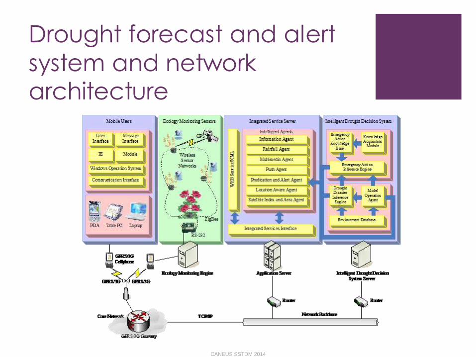
Drought forecast and alert
system and network architecture
CANEUS SSTDM 2014

Real-time flood
monitoring and warning system
CANEUS SSTDM 2014

Sensing Parameters
The system for real-time monitoring of water conditions:
water level
flow
precipitation level
This system was developed to be employed in monitoring flood in Nakhon Si Thammarat, a southern province in Thailand
CANEUS SSTDM 2014
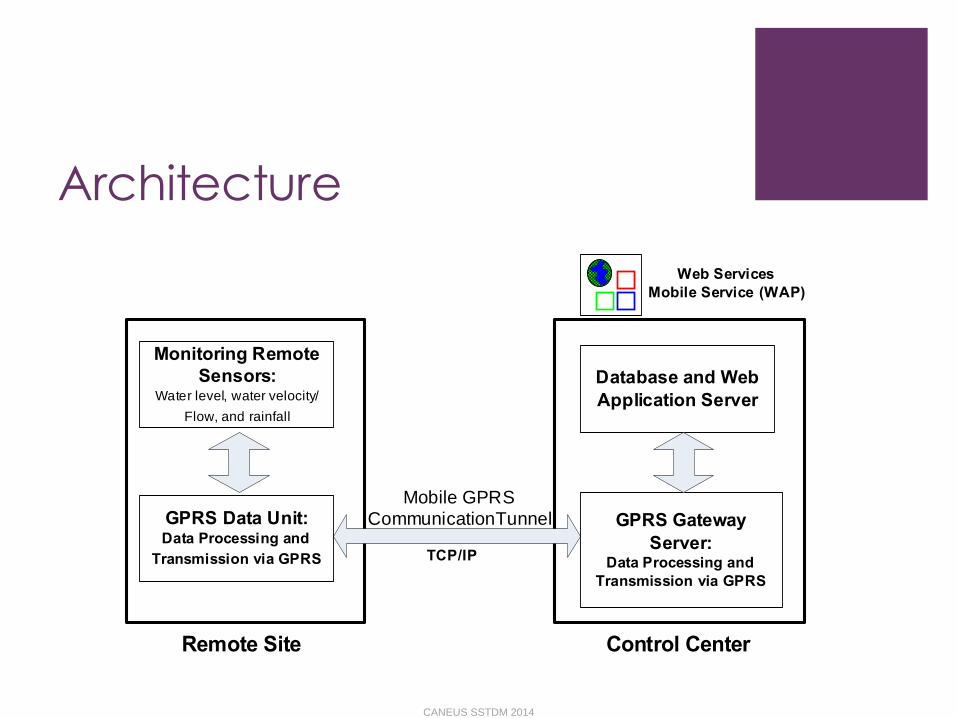
ArchitectureJ. Sunkpho & C. Ootamakorn / Songklanakarin J. Sci. Technol. 33 (2), 227-235, 2011230
network. Finally, the implementation of the data transmitting
and processing unit and the database and application server
are described.
3.1 System architecture
In this section, we describe the underpinnings of the
proposed flood monitoring system of using remote sensing to
support the real-time and reliable data acquisitions. The
system architecture can be illustrated at the highest level in
Figure 2. The system consists of three major modules. The
first module (Monitoring Sensors) includes our customized
sensors for measuring water level, flow, and precipitation.
The second module is the data transmission and processing
module, of which each resides at the remote sites and the
control center in order to enable the control center to commu-
nicate with the remote sensor devices as if they are directly
connected by a cable. In fact, the data goes through mobile
General Packet Radio Service (GPRS) tunnel. The data
processing and transmission module installed at a remote site
is a GPRS Data Unit (GDU) while the GPRS gateway server is
implemented at the control center. The third module runs as
a database and application server/computer, which has the
functionalities to process the three types of information in
real-time and make them accessible online. That is, the system
is implemented as a web-based application that provides
users with views of water condition. End user can access
this system through web browser (Internet) or Mobile
devices (WAP: Wireless Application Protocol).
In order to handle various types of data at a remote
site, we employ a GDU manufactured by NXN Technology
(NXN 2007) to support both computing and communication
capabilities. The GDU has a data logger of 2MB memory, which
can be used to store monitored data when the communica-
tion is unavailable. In addition, Global Positioning Systems
(GPS) is included in the unit in order for the unit to automati-
cally provide the location information. The application of
GDU represents a new and potentially powerful tool in flood
monitoring. The challenges in the successful application of
GDU are the development of a monitoring system that enable
many GDUs that spread across a long distance to communi-
cate to the control center in a timely, efficient, and robust
manner. There is an API-based application installed at the
control center to manage and organize a set of GDUs in the
15 various locations as shown in Figure 1.
3.2 Monitoring sensors
In Figure 3, we show the structure of each monitoring
sensor unit at a remote site. In monitoring sensor module,
we employ 1) an ultrasonic Doppler instrument with a 128K
data logger, called STARFLOW, manufactured by UNIDATA
(UNIDATA 2007), Australia, to monitor water level and
velocity (See Figure 4) and 2) a precipitation sensor by
Fischer (MetoClima 2007) to measure the amount and inten-
sity of rain (See Figure 5). STARFLOW is deployed under
Monitoring Remote
Sensors:Water level, water velocity/
Flow, and rainfall
GPRS Data Unit: Data Processing and
Transmission via GPRS
Remote Site
Database and Web
Application Server
GPRS Gateway
Server: Data Processing and
Transmission via GPRS
Control Center
Mobile GPRS
CommunicationTunnel
Web Services
Mobile Service (WAP)
TCP/IP
Monitoring Sensors:
GPRS Data Unit:
Remote Site
STARFLOW:Water level and
water velocity
Precipitation
sensor:Rainfall
RS-232 and
SDI-12
Digital
Input
Data Processing
and Logger
GPRS
Communication
Module
Figure 2. The highest-level system architecture.
Figure 3. The structure of water monitoring unit at a remote site.
Figure 4. STARFLOW sensor and its installation.
Figure 5. Precipitation sensor and its installation.
CANEUS SSTDM 2014

Ubiquitious Mult-Context
Model
CANEUS SSTDM 2014
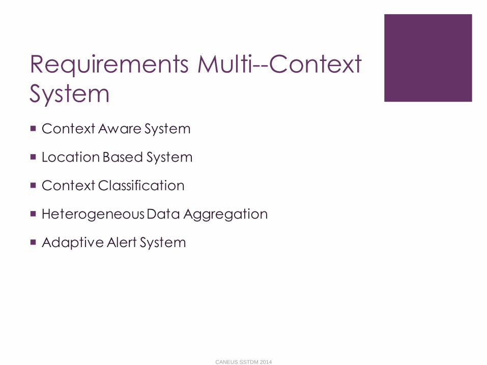
Requirements Multi--Context
System
Context Aware System
Location Based System
Context Classification
Heterogeneous Data Aggregation
Adaptive Alert System
CANEUS SSTDM 2014
Monitor and Detect major disasters
Monitor and Detect other multiple types of disasters instigated by the major disaster
CANEUS SSTDM 2014

References
1. https://www.dosomething.org/actnow/tipsandtools/11-facts-about-disasters
2. http://www.iis.sinica.edu.tw/JISE/2006/200607_03.pdf
3. http://rdo.psu.ac.th/sjstweb/journal/33-2/0125-3395-33-2-227-235.pdf
CANEUS SSTDM 2014

Thank You
CANEUS SSTDM 2014