wisconsin nrcs direct volume method bank recession rate
TRANSCRIPT
2
Executive Summary The City of Ramsey contracted the Anoka Conservation District to complete an inventory of riverbank condition along the entire 5.8 miles of City that border the Mississippi River. The inventory provides the City with a comprehensive record of bank condition. Ten stretches of riverbank with severe or very severe erosion were identified, which if stabilized, would reduce sediment loading to the river by 5,148 tons per year. The inventory is structured as this report as well as an atlas. The report provides details on the methodology used to estimate bank erosion severity and potential benefits provided by stabilizing the most severely eroding sections of riverbank. The 10 most severely eroding sections of riverbank are also detailed in the report with individual site profiles to highlight additional information and potential solutions. The atlas is presented in Appendix A and provides a complete record of aerial photographs with the corresponding erosion severity categorizations and key pictures collected during the field work portion of this effort. As not all pictures are presented in the atlas, the final deliverables also include the complete picture inventory collected in early December 2015.
Methods
Field Work The project scope was determined to be the entire 5.8 miles of City that border the Mississippi River. An atlas of the target area was printed prior to conducting the field work to serve as a navigation tool on the river and ensure complete coverage of the riverbank. The inventory was conducted on December 10th and 11th, 2015. The timing was optimal because the river level was relatively low, bank vegetation was dormant, and snow had not yet fallen to obscure the bank. Other times of the year were considered for the inventory, but frequent high water levels in the spring, dense bank vegetation in the summer, and river ice and snow on the bank in the winter all prevented the collection of a useful picture inventory. The inventory crew consisted of two Anoka Conservation District (ACD) staff members. A small boat was used to navigate the river and take geotagged pictures using a handheld GPS. These pictures can be viewed similar to pictures taken on a standard camera, but they also contain spatial information (i.e. X and Y coordinates). This feature allows them to be accurately mapped in GIS software. In order to take high quality photos, the boat navigated at idle speed typically between 50 and 100 feet from shore depending on water depth.
Wisconsin NRCS Direct Volume Method – Bank Recession Rate Categorizations The picture inventory was used to digitize a polyline in GIS along the entire riverbank. Using the Wisconsin NRCS Direct Volume Method, the polyline was classified as slight, moderate, severe, or very severe with respect to erosion severity (Table 1). These erosion categorizations were then converted to lateral recession rates using the table below for use in soil loss calculations.
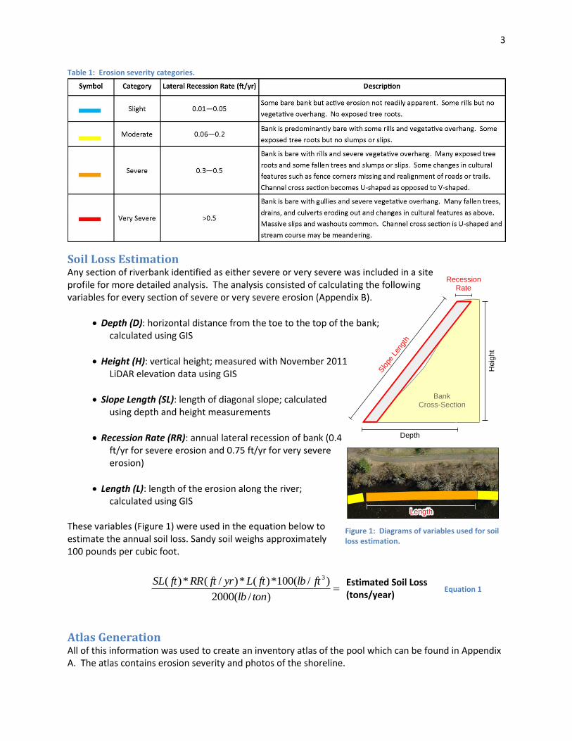
3
Estimated Soil Loss (tons/year)
Length
Soi
l Los
s
RecessionRate
BankCross-Section
Heig
ht
Depth
Slo
pe L
engt
h
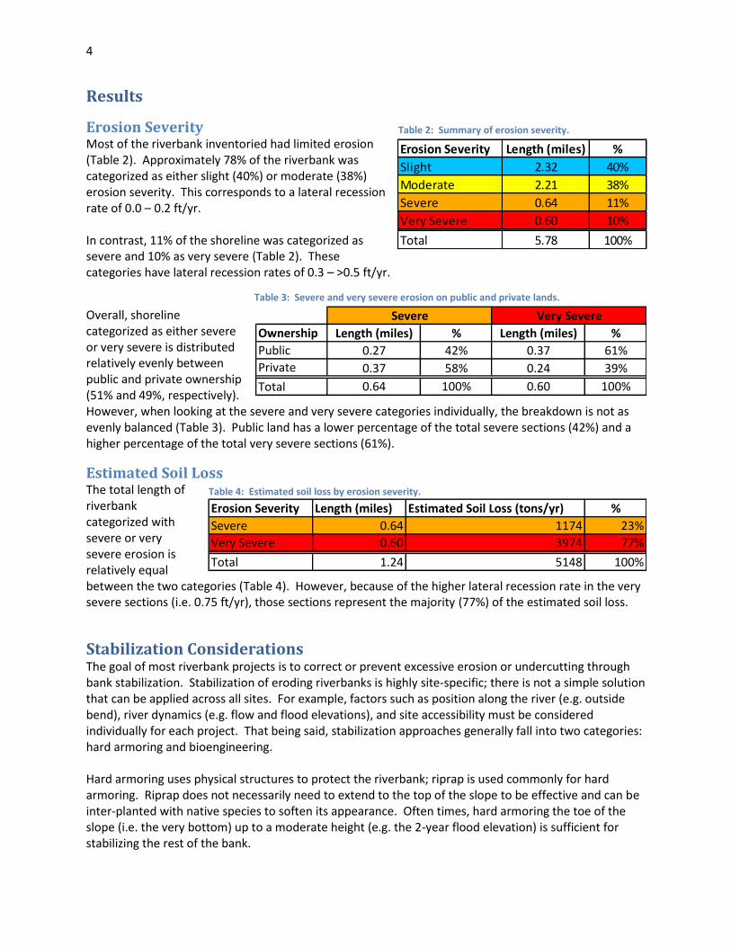
Table 1: Erosion severity categories.
Soil Loss Estimation Any section of riverbank identified as either severe or very severe was included in a site profile for more detailed analysis. The analysis consisted of calculating the following variables for every section of severe or very severe erosion (Appendix B).
Depth (D): horizontal distance from the toe to the top of the bank; calculated using GIS
Height (H): vertical height; measured with November 2011 LiDAR elevation data using GIS
Slope Length (SL): length of diagonal slope; calculated using depth and height measurements
Recession Rate (RR): annual lateral recession of bank (0.4 ft/yr for severe erosion and 0.75 ft/yr for very severe erosion)
Length (L): length of the erosion along the river; calculated using GIS
These variables (Figure 1) were used in the equation below to estimate the annual soil loss. Sandy soil weighs approximately 100 pounds per cubic foot.
Atlas Generation All of this information was used to create an inventory atlas of the pool which can be found in Appendix A. The atlas contains erosion severity and photos of the shoreline.
)/(2000
)/(100*)(*)/(*)( 3
tonlb
ftlbftLyrftRRftSL
Figure 1: Diagrams of variables used for soil loss estimation.
Equation 1
4
Results
Erosion Severity Most of the riverbank inventoried had limited erosion (Table 2). Approximately 78% of the riverbank was categorized as either slight (40%) or moderate (38%) erosion severity. This corresponds to a lateral recession rate of 0.0 – 0.2 ft/yr. In contrast, 11% of the shoreline was categorized as severe and 10% as very severe (Table 2). These categories have lateral recession rates of 0.3 – >0.5 ft/yr.
Overall, shoreline categorized as either severe or very severe is distributed relatively evenly between public and private ownership (51% and 49%, respectively). However, when looking at the severe and very severe categories individually, the breakdown is not as evenly balanced (Table 3). Public land has a lower percentage of the total severe sections (42%) and a higher percentage of the total very severe sections (61%).
Estimated Soil Loss The total length of riverbank categorized with severe or very severe erosion is relatively equal between the two categories (Table 4). However, because of the higher lateral recession rate in the very severe sections (i.e. 0.75 ft/yr), those sections represent the majority (77%) of the estimated soil loss.
Stabilization Considerations The goal of most riverbank projects is to correct or prevent excessive erosion or undercutting through bank stabilization. Stabilization of eroding riverbanks is highly site-specific; there is not a simple solution that can be applied across all sites. For example, factors such as position along the river (e.g. outside bend), river dynamics (e.g. flow and flood elevations), and site accessibility must be considered individually for each project. That being said, stabilization approaches generally fall into two categories: hard armoring and bioengineering. Hard armoring uses physical structures to protect the riverbank; riprap is used commonly for hard armoring. Riprap does not necessarily need to extend to the top of the slope to be effective and can be inter-planted with native species to soften its appearance. Often times, hard armoring the toe of the slope (i.e. the very bottom) up to a moderate height (e.g. the 2-year flood elevation) is sufficient for stabilizing the rest of the bank.
Table 2: Summary of erosion severity.
Erosion Severity Length (miles) %
Slight 2.32 40%
Moderate 2.21 38%
Severe 0.64 11%
Very Severe 0.60 10%
Total 5.78 100%
Table 3: Severe and very severe erosion on public and private lands.
Table 4: Estimated soil loss by erosion severity.
Ownership Length (miles) % Length (miles) %
Public 0.27 42% 0.37 61%
Private 0.37 58% 0.24 39%
Total 0.64 100% 0.60 100%
Severe Very Severe
Erosion Severity Length (miles) Estimated Soil Loss (tons/yr) %
Severe 0.64 1174 23%
Very Severe 0.60 3974 77%
Total 1.24 5148 100%
5
Bioengineering approaches combine engineering techniques with ecological principles to stabilize the bank. They rely heavily on deep-rooted native plants along with a variety of other natural materials to reinforce and stabilize eroding riverbanks. Bioengineering also incorporates the goals of fish and wildlife habitat restoration, maintenance of water quality, and aesthetic considerations. In addition to bank stabilization, many benefits are achieved through bioengineering:
Improved aquatic and terrestrial habitat,
Increased connectivity among habitats along the riverbank,
Decreased water temperatures through shading, and
Improved soil and water quality. The stabilization solution for an eroding riverbank could certainly use a combination of hard armoring and bioengineering. In fact, ACD often recommends this combination on large river systems such as the Mississippi River because of the benefits provided by both approaches.
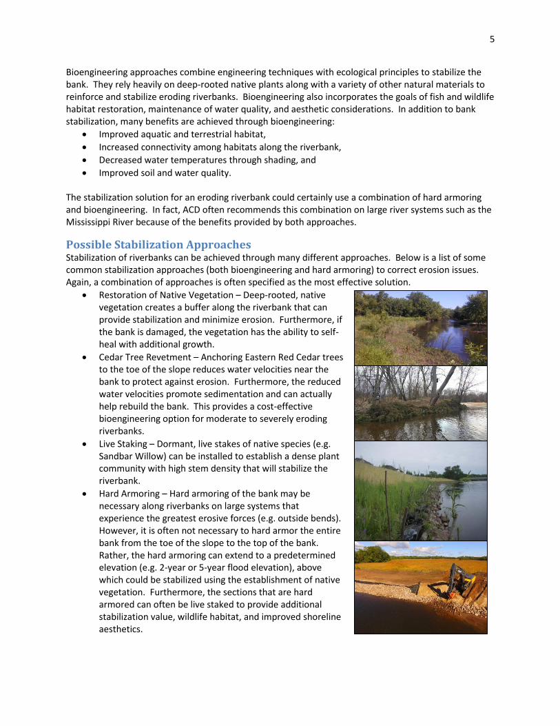
Possible Stabilization Approaches Stabilization of riverbanks can be achieved through many different approaches. Below is a list of some common stabilization approaches (both bioengineering and hard armoring) to correct erosion issues. Again, a combination of approaches is often specified as the most effective solution.
Restoration of Native Vegetation – Deep-rooted, native vegetation creates a buffer along the riverbank that can provide stabilization and minimize erosion. Furthermore, if the bank is damaged, the vegetation has the ability to self-heal with additional growth.
Cedar Tree Revetment – Anchoring Eastern Red Cedar trees to the toe of the slope reduces water velocities near the bank to protect against erosion. Furthermore, the reduced water velocities promote sedimentation and can actually help rebuild the bank. This provides a cost-effective bioengineering option for moderate to severely eroding riverbanks.
Live Staking – Dormant, live stakes of native species (e.g. Sandbar Willow) can be installed to establish a dense plant community with high stem density that will stabilize the riverbank.
Hard Armoring – Hard armoring of the bank may be necessary along riverbanks on large systems that experience the greatest erosive forces (e.g. outside bends). However, it is often not necessary to hard armor the entire bank from the toe of the slope to the top of the bank. Rather, the hard armoring can extend to a predetermined elevation (e.g. 2-year or 5-year flood elevation), above which could be stabilized using the establishment of native vegetation. Furthermore, the sections that are hard armored can often be live staked to provide additional stabilization value, wildlife habitat, and improved shoreline aesthetics.
6
Bank Reshaping – Reshaping a severely eroding riverbank may be necessary in order to stabilize vertical, bare banks. This approach must be coupled with other stabilization techniques because in and of itself it does not provide any stabilization benefits. It only creates a bank with suitable slopes for other stabilization approaches.
Favorable Practices for Riverbank Property Owners Managing a riverbank can present a difficult challenge for property owners. Often times, a misunderstanding of factors that contribute to erosion can actually exacerbate the issue. Below is a list of practices that should be followed by property owners adjacent to rivers in order to minimize erosion and protect their property.
Avoid mowing near the edge of the bluff or riverbank. Turf grasses have very shallow root systems, providing little soil stability. Deeper rooted species are also better at filtering out excess nutrients and sediments in runoff.
Control runoff from downspouts and other hard surfaces at the top of the slope to prevent it from flowing over the riverbank. Promote infiltration of rain water into the soil but away from the riverbank where possible, or provide a pipe conduit down to the water’s edge to transport water if necessary.
Dispose of yard waste properly to avoid smothering riverbank vegetation and contributing nutrients to the river, which commonly occurs when leaves and grass clippings are thrown over the riverbank.
Plant desirable species with preference for multi-stemmed plants with deep, dense, fibrous root systems. However, ensure the species are well suited to the soil type, moisture level, and available sunlight or they will not thrive.
Prune lower branches on trees to increase the amount of light that penetrates to the ground. This will increase plant growth at ground level where the stems, roots, and foliage will help keep soil in place.
Remove buckthorn, which is an invasive plant that is believed to release a natural herbicide that suppresses nearby plant growth.
Remove fallen trees because they can redirect water toward the bank and exacerbate erosive river forces.
Remove grapevines, which smother trees, shade out understory species, and provide little soil stabilization benefits.
7
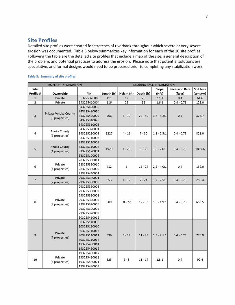
Site Profiles Detailed site profiles were created for stretches of riverbank throughout which severe or very severe erosion was documented. Table 5 below summarizes key information for each of the 10 site profiles. Following the table are the detailed site profiles that include a map of the site, a general description of the problem, and potential practices to address the erosion. Please note that potential solutions are speculative, and formal designs would need to be prepared prior to completing any stabilization work. Table 5: Summary of site profiles.
Site
Profile # Ownership PIN Length (ft) Height (ft) Depth (ft)
Slope
(H:V)
Recession Rate
(ft/yr)
Soil Loss
(tons/yr)
1 Private 353225320005 111 12 25 2.1:1 0.4 61.6
2 Private 343225410004 116 22 36 1.6:1 0.4 - 0.75 123.0
3Private/Anoka County
(5 properties)
343225420005
343225420010
343225420009
343225310025
343225310023
566 6 - 10 22 - 40 3.7 - 4.2:1 0.4 323.7
4Anoka County
(3 properties)
343225320001
343225230003
333225110003
1227 4 - 16 7 - 30 1.8 - 2.5:1 0.4 - 0.75 821.0
5Anoka County
(4 properties)
333225110003
333225110002
333225120001
333225120005
1920 4 - 20 8 - 33 1.5 - 2.0:1 0.4 - 0.75 1869.6
6Private
(4 properties)
283225330011
283225330010
283225330009
293225440001
412 6 15 - 24 2.5 - 4.0:1 0.4 152.0
7Private
(2 properties)
293225340001
293225330005653 4 - 12 7 - 24 1.7 - 2.5:1 0.4 - 0.75 280.4
8Private
(8 properties)
293225330003
293225330002
293225330001
293225320007
293225320006
293225320005
293225320003
303225410012
589 8 - 22 12 - 33 1.5 - 1.9:1 0.4 - 0.75 653.5
9Private
(7 properties)
303225110030
303225110010
303225110013
303225110011
303225110012
193225430014
193225430015
639 6 - 24 11 - 35 1.5 - 2.1:1 0.4 - 0.75 770.9
10Private
(4 properties)
193225430017
193225430018
193225430021
193225430003
325 6 - 8 11 - 14 1.8:1 0.4 92.4
PROPERTY INFORMATION ERODING FACE INFORMATION
8
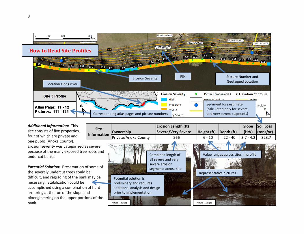
Additional Information: This site consists of five properties, four of which are private and one public (Anoka County). Erosion severity was categorized as severe because of the many exposed tree roots and undercut banks. Potential Solution: Preservation of some of the severely undercut trees could be difficult, and regrading of the bank may be necessary. Stabilization could be accomplished using a combination of hard armoring at the toe of the slope and bioengineering on the upper portions of the bank. Picture (112).jpg Picture (121).jpg
Ownership
Erosion Length (ft)
Severe/Very Severe Height (ft) Depth (ft)
Slope
(H:V)
Soil Loss
(tons/yr)
Private/Anoka County 566 6 - 10 22 - 40 3.7 - 4.2 323.7
Site
Information
How to Read Site Profiles
Location along river
Erosion Severity
Combined length of all severe and very severe erosion segments across site
Potential solution is preliminary and requires additional analysis and design prior to implementation.
PIN Picture Number and Geotagged Location
Representative pictures
Value ranges across sites in profile
Sediment loss estimate (calculated only for severe and very severe segments) Corresponding atlas pages and picture numbers
9
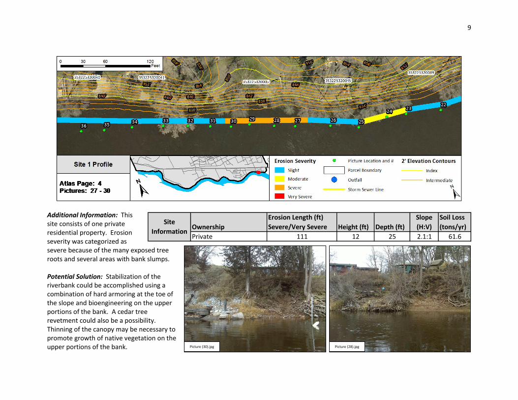
Additional Information: This site consists of one private residential property. Erosion severity was categorized as severe because of the many exposed tree roots and several areas with bank slumps. Potential Solution: Stabilization of the riverbank could be accomplished using a combination of hard armoring at the toe of the slope and bioengineering on the upper portions of the bank. A cedar tree revetment could also be a possibility. Thinning of the canopy may be necessary to promote growth of native vegetation on the upper portions of the bank.
Ownership
Erosion Length (ft)
Severe/Very Severe Height (ft) Depth (ft)
Slope
(H:V)
Soil Loss
(tons/yr)
Private 111 12 25 2.1:1 61.6
Site
Information
Picture (28).jpg Picture (30).jpg
10
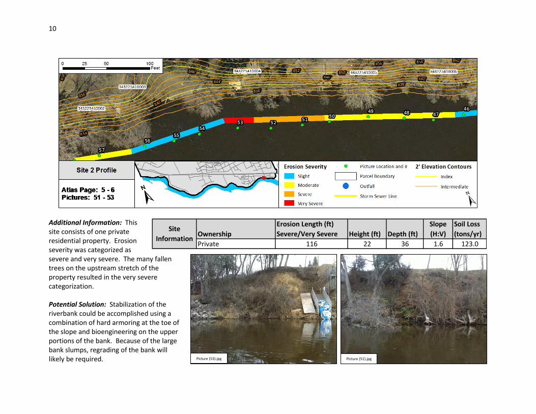
Additional Information: This site consists of one private residential property. Erosion severity was categorized as severe and very severe. The many fallen trees on the upstream stretch of the property resulted in the very severe categorization. Potential Solution: Stabilization of the riverbank could be accomplished using a combination of hard armoring at the toe of the slope and bioengineering on the upper portions of the bank. Because of the large bank slumps, regrading of the bank will likely be required. Picture (51).jpg Picture (53).jpg
Ownership
Erosion Length (ft)
Severe/Very Severe Height (ft) Depth (ft)
Slope
(H:V)
Soil Loss
(tons/yr)
Private 116 22 36 1.6 123.0
Site
Information
11
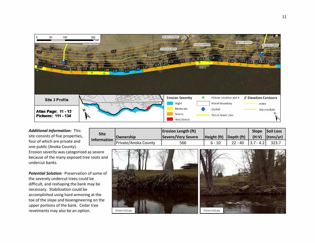
Additional Information: This site consists of five properties, four of which are private and one public (Anoka County). Erosion severity was categorized as severe because of the many exposed tree roots and undercut banks. Potential Solution: Preservation of some of the severely undercut trees could be difficult, and reshaping the bank may be necessary. Stabilization could be accomplished using hard armoring at the toe of the slope and bioengineering on the upper portions of the bank. Cedar tree revetments may also be an option. Picture (112).jpg Picture (121).jpg
Ownership
Erosion Length (ft)
Severe/Very Severe Height (ft) Depth (ft)
Slope
(H:V)
Soil Loss
(tons/yr)
Private/Anoka County 566 6 - 10 22 - 40 3.7 - 4.2 323.7
Site
Information
12
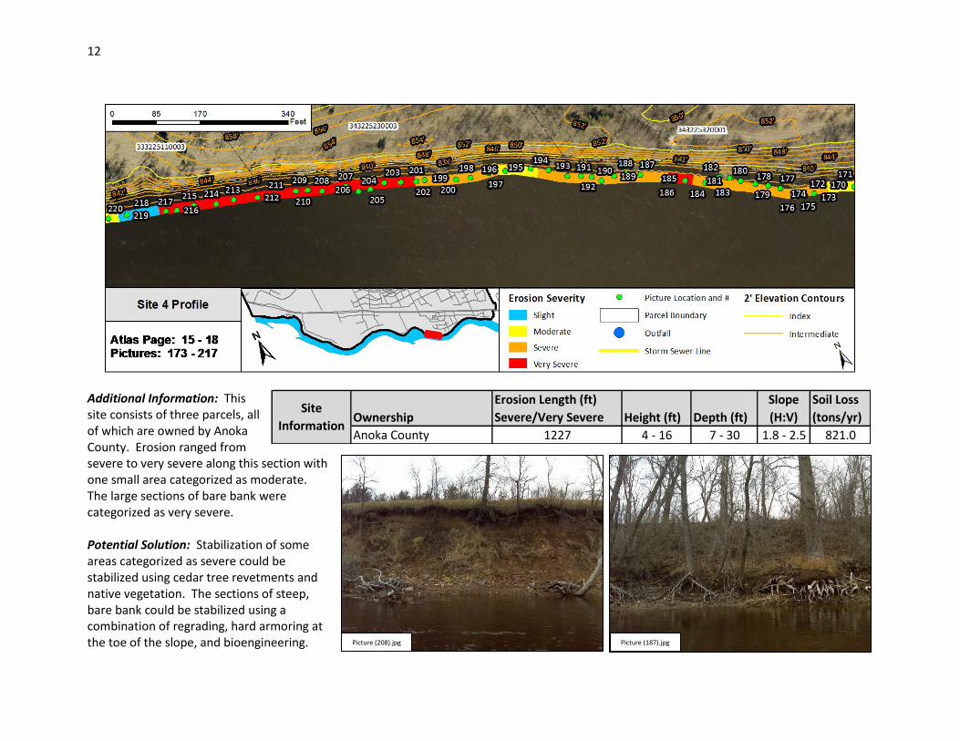
Additional Information: This site consists of three parcels, all of which are owned by Anoka County. Erosion ranged from severe to very severe along this section with one small area categorized as moderate. The large sections of bare bank were categorized as very severe. Potential Solution: Stabilization of some areas categorized as severe could be stabilized using cedar tree revetments and native vegetation. The sections of steep, bare bank could be stabilized using a combination of regrading, hard armoring at the toe of the slope, and bioengineering. Picture (187).jpg Picture (208).jpg
Ownership
Erosion Length (ft)
Severe/Very Severe Height (ft) Depth (ft)
Slope
(H:V)
Soil Loss
(tons/yr)
Anoka County 1227 4 - 16 7 - 30 1.8 - 2.5 821.0
Site
Information

13
Additional Information: This site consists of four parcels, all of which are owned by Anoka County. Erosion ranged from severe to very severe along this section with short sections categorized as moderate. The large sections of bare bank were categorized as very severe. Potential Solution: Stabilization of some areas categorized as severe could be stabilized using cedar tree revetments and native vegetation. The sections of steep, bare bank could be stabilized using a combination of regrading, hard armoring at the toe of the slope, and bioengineering. Picture (235).jpg Picture (259).jpg
Ownership
Erosion Length (ft)
Severe/Very Severe Height (ft) Depth (ft)
Slope
(H:V)
Soil Loss
(tons/yr)
Anoka County 1920 4 - 20 8 - 33 1.5 - 2.0 1869.6
Site
Information
14
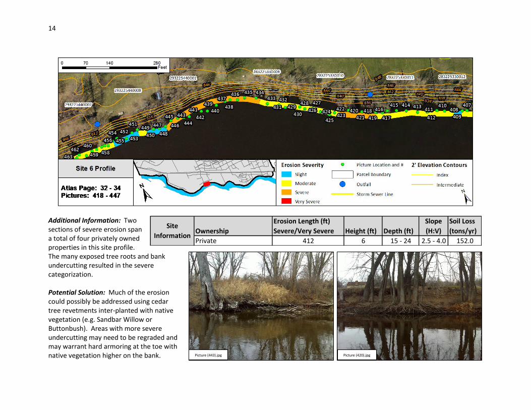
Additional Information: Two sections of severe erosion span a total of four privately owned properties in this site profile. The many exposed tree roots and bank undercutting resulted in the severe categorization. Potential Solution: Much of the erosion could possibly be addressed using cedar tree revetments inter-planted with native vegetation (e.g. Sandbar Willow or Buttonbush). Areas with more severe undercutting may need to be regraded and may warrant hard armoring at the toe with native vegetation higher on the bank. Picture (420).jpg Picture (443).jpg
Ownership
Erosion Length (ft)
Severe/Very Severe Height (ft) Depth (ft)
Slope
(H:V)
Soil Loss
(tons/yr)
Private 412 6 15 - 24 2.5 - 4.0 152.0
Site
Information

15
Additional Information: Erosion at this site spans two private properties and ranges from severe to very severe. Much of the severe erosion consists of exposed tree roots and some bank undercutting. The very severe sections have fallen trees and bare bank. Potential Solution: The severe sections may be effectively stabilized with cedar tree revetments and native vegetation (e.g. Sandbar Willow or Buttonbush). Areas with fallen trees and bare bank may need to be regraded and hard armored at the toe with native vegetation farther up the bank. Picture (623).jpg Picture (639).jpg
Ownership
Erosion Length (ft)
Severe/Very Severe Height (ft) Depth (ft)
Slope
(H:V)
Soil Loss
(tons/yr)
Private 653 4 - 12 7 - 24 1.7 - 2.5 280.4
Site
Information

16
Additional Information: Erosion at this site spans eight private properties and ranges from severe to very severe. The very severe sections have fallen trees and bare bank. Potential Solution: Most of the erosion sections are very severe and will likely require regrading of the bank. Hard armoring of the slope toe up to a modest elevation (e.g. 2-year or 5-year flood elevation) with native vegetation establishment on the remaining areas higher up the bank may be an effective stabilization option. Picture (670).jpg Picture (698).jpg
Ownership
Erosion Length (ft)
Severe/Very Severe Height (ft) Depth (ft)
Slope
(H:V)
Soil Loss
(tons/yr)
Private 589 8 - 22 12 - 33 1.5 - 1.9 653.5
Site
Information
17
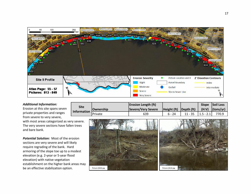
Additional Information: Erosion at this site spans seven private properties and ranges from severe to very severe, with most areas categorized as very severe. The very severe sections have fallen trees and bare bank. Potential Solution: Most of the erosion sections are very severe and will likely require regrading of the bank. Hard armoring of the slope toe up to a modest elevation (e.g. 2-year or 5-year flood elevation) with native vegetation establishment on the higher bank areas may be an effective stabilization option. Picture (813).jpg Picture (844).jpg
Ownership
Erosion Length (ft)
Severe/Very Severe Height (ft) Depth (ft)
Slope
(H:V)
Soil Loss
(tons/yr)
Private 639 6 - 24 11 - 35 1.5 - 2.1 770.9
Site
Information
18
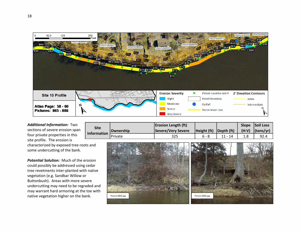
Additional Information: Two sections of severe erosion span four private properties in this site profile. The erosion is characterized by exposed tree roots and some undercutting of the bank. Potential Solution: Much of the erosion could possibly be addressed using cedar tree revetments inter-planted with native vegetation (e.g. Sandbar Willow or Buttonbush). Areas with more severe undercutting may need to be regraded and may warrant hard armoring at the toe with native vegetation higher on the bank.
Picture (868).jpg Picture (883).jpg
Ownership
Erosion Length (ft)
Severe/Very Severe Height (ft) Depth (ft)
Slope
(H:V)
Soil Loss
(tons/yr)
Private 325 6 - 8 11 - 14 1.8 92.4
Site
Information