wnv ground spray target area 2013 - dallascityhall.com · jeffer son wnv ground spray target area...
TRANSCRIPT

1 inch = 824 feet
Spray Date: June 17 (10p.m.) Through June 18 2013 (3 a.m.)
RY
EO
AK BEND
CHEYE
IDLEWYLDMEADOWLARK
WH
ITE
OA
K
CROSSOVER
CAROLINA OAKS
CITADEL
FL
EE
T
LE
RO
Y
SAND SPRINGS
NORWICHANDOVER
RE
D C
LO
UD
AS
PE
N
NA
MU
R
NOWETA
ME
RID
EN
CHATHAM SQUARE
GROVERIDGE
CHELMSFORD
PICAD
ILLY
WATERBURY
CO
RK
OAK
ACUNA
WHITINGHAM
NE
W H
AV
EN
TAMWORTH
MO
SS
GLE
N
NAN
TU
CKET
VIL
LAG
E
FO
RT
BE
ND
BELINDA
BLACKJACK OAKS
CHATHAM
SHELBURNE
MORROW
EA
ST
ER
N O
AK
SS
UM
MIT
OA
KCASTLE BAY
LBARGER
WINTER OAK
SU
MM
ER
OA
KS
CLAYTON OAKS
SAWTOOTH OAK
WATER OAKS
SU
MM
IT
BIL
OX
I
KO
ON
CE
EA
RL
CO
VE
BRIARBANK
LE
WIS
TO
N
ME
NLO
BE
LL
E S
TA
RR
WO
OD
LE
AF
QU
AIL
HO
LLO
W A
PT
S
GULF PALMS
BRIGGS
OAK TERRACE
ABRAHAM
EDGECREEK
CABLEWOOD
PASEO BONITA
SHAD
Y O
AKS
APTS
AUGUST
PARK APTS
NA
IRA
KERRVILLE
NEW
BEDFORD
WOOD HEIGHTS
MY
RT
LE
CO
VE
AP
TS
MOUNTAIN BEND
EASTHAM
HILLHOUSE
OLDE TOWNE
ROWE
CO
RV
ET
TE
CHATEAU
RIDGE OAK
OAK BRANCH
ALTACREST
HUSTEAD
CEDAR MOUNTAIN
JENNIE LEE
OLDE
VILLAGE
PA
SE
O P
AR
AIS
O
CASTLEFIELD
HIGHFIELD
CRESTSHIRE
BLUFFCREEK
SCYENE
SAM
HOUSTON
MA
ST
ER
S
WHITFIELD
ST
AU
GU
ST
IN
E
BRUTON
WNV Ground Spray Target Area 2013WNV Ground Spray Target Area 2013
Data Source:Roads, Waterways, Lakes, Parks - City of Dallas Enterprise GISSpray Areas - City of Dallas Code Compliance Services & Dallas County Environmental Services
City of Dallas GIS Map Disclaimer:The accuracy of this data within this map is not to be taken /used as data produced by a Registered Professional LandSurveyor for the State of Texas.* ‘This product is forinformational purposes and may not have been preparedfor or be suitable for legal, engineering, or surveying purposes.It does not represent an on-the-ground survey and representsonly the approximate relative location of property boundaries.The City of Dallas makes no representation of any kind, including,but not limited to, warranties of merchantability or fitness for a
particular purpose or use, nor are any such warranties to beimplied with respect to the accuracy information/datapresented on this map. Transfer, copies and/or use of informationin this map without the presentation of this disclaimer is prohibited.City of Dallas GIS* State of Texas: H.B. 1147 (W. Smith) – 05/27/2011,Effective on 09/01/2011
·1 inch = 824 feet
Monday, June 17, 2013 10:20:49 AMMonday, June 17, 2013 10:20:49 AMMonday, June 17, 2013 10:20:49 AMMonday, June 17, 2013 10:20:49 AMFile Location: U:\Code\MosquitoOngoing2013\2013-04-25_KT_GroundSprayNotificationMaps_WNV2013File Location: U:\Code\MosquitoOngoing2013\2013-04-25_KT_GroundSprayNotificationMaps_WNV2013File Location: U:\Code\MosquitoOngoing2013\2013-04-25_KT_GroundSprayNotificationMaps_WNV2013File Location: U:\Code\MosquitoOngoing2013\2013-04-25_KT_GroundSprayNotificationMaps_WNV2013
Prepared By: Dallas Code CompliancePrepared By: Dallas Code CompliancePrepared By: Dallas Code CompliancePrepared By: Dallas Code ComplianceProperty of: City of Dallas Enterprise GISProperty of: City of Dallas Enterprise GISProperty of: City of Dallas Enterprise GISProperty of: City of Dallas Enterprise GIS
For illustrative purposes only.For illustrative purposes only.For illustrative purposes only.For illustrative purposes only.

1 inch = 824 feet
Spray Date: June 17 (10p.m.) Through June 18 2013 (3 a.m.)
SH
AS
TA
VIN
CE
NT
BA
RN
ET
T
CLARENDON
REDBUDD
RY
DE
N
FALLS
BARNARD
ROSEMARY
JUNE
POINSETTIA
ROCKFORD
DUTTON
BROOKLYNDELL
KE
AT
S
TEXAS
MOLER
BURLINGDELL
PAMPAS
RED BUDG
AU
CH
O
CO
WA
RT
RIV
IER
ABROOKLYN
RIC
HM
ON
DE
LL
OL
DE
N
MA
RT
IND
EL
L
PIE
RC
E
PATHFINDER
DU
MA
NE
MA
RS
HA
LL
DE
LL
MC
LE
AN
RA
VIN
IA
EL
I
HIGGINS
WRIGHT
RA
VIN
IA
NO
RM
AN
JE
AN
AN
N
BRANDON
WILTON
SEARCY
GIBSONDELL
PH
INN
EY
WESTERN
GRAFTON
SHARON
KINGSTON
ASTER
EMMETT
IVANDELLPENROD
DEMPSTER
GLENHAVEN
SHELLEY
DAWES
VIRGINIA
ROLINDA
THIBETWALKER
KERNACK BU
RN
S
BENTLEY
CO
OM
BS
CR
EE
K
GIL
PIN
TA
RP
LE
Y
BURLINGTON
CATHERINE
WESTMORELAND
CLARENDON
JEFFERSON
WNV Ground Spray Target Area 2013WNV Ground Spray Target Area 2013
Data Source:Roads, Waterways, Lakes, Parks - City of Dallas Enterprise GISSpray Areas - City of Dallas Code Compliance Services & Dallas County Environmental Services
City of Dallas GIS Map Disclaimer:The accuracy of this data within this map is not to be taken /used as data produced by a Registered Professional LandSurveyor for the State of Texas.* ‘This product is forinformational purposes and may not have been preparedfor or be suitable for legal, engineering, or surveying purposes.It does not represent an on-the-ground survey and representsonly the approximate relative location of property boundaries.The City of Dallas makes no representation of any kind, including,but not limited to, warranties of merchantability or fitness for a
particular purpose or use, nor are any such warranties to beimplied with respect to the accuracy information/datapresented on this map. Transfer, copies and/or use of informationin this map without the presentation of this disclaimer is prohibited.City of Dallas GIS* State of Texas: H.B. 1147 (W. Smith) – 05/27/2011,Effective on 09/01/2011
·1 inch = 824 feet
Monday, June 17, 2013 09:59:03 AMMonday, June 17, 2013 09:59:03 AMMonday, June 17, 2013 09:59:03 AMMonday, June 17, 2013 09:59:03 AMFile Location: U:\Code\MosquitoOngoing2013\2013-04-25_KT_GroundSprayNotificationMaps_WNV2013File Location: U:\Code\MosquitoOngoing2013\2013-04-25_KT_GroundSprayNotificationMaps_WNV2013File Location: U:\Code\MosquitoOngoing2013\2013-04-25_KT_GroundSprayNotificationMaps_WNV2013File Location: U:\Code\MosquitoOngoing2013\2013-04-25_KT_GroundSprayNotificationMaps_WNV2013
Prepared By: Dallas Code CompliancePrepared By: Dallas Code CompliancePrepared By: Dallas Code CompliancePrepared By: Dallas Code ComplianceProperty of: City of Dallas Enterprise GISProperty of: City of Dallas Enterprise GISProperty of: City of Dallas Enterprise GISProperty of: City of Dallas Enterprise GIS
For illustrative purposes only.For illustrative purposes only.For illustrative purposes only.For illustrative purposes only.

1 inch = 824 feet
Spray Date: June 17 (10p.m.) Through June 18 2013 (3 a.m.)
���289BROOKSHIRE
PA
RK
PR
ES
TO
N
ORCHID
FOREST
BURGUNDY
PRES
TON
RO
YAL SC
PARK VILLAGE
TIB
BS
AZALEA
ED
GE
ME
RE
CA
ME
LL
IA
ROYAL
CRESTELDERWOOD
BOCA RATON
PRESTON HAVEN
DEL ROY
MEADOW CREST
DA
LLA
S N
OR
TH
TO
LLW
AY
MANZANO
RO
YA
L
FORESTSHIRE
PA
RK
CH
ES
TE
R
TRAIL MEADOW
CO
RV
AL
LIS
CEDRO
ORCHI
LOS AR
BOLES
PA
RW
EN
RO
YA
LS
HIR
E
QU
INC
Y
ROYALTON
NU
ES
TR
A
TH
AC
KE
RY
LAWN
HAV
EN
REX
LAVENDALE
FOREST CREEK
OVER
DOWNS
MUM
YORKSHIRE
JA
ME
ST
OW
N
EA
ST
VIE
W
VILLA
GER
NORTHLAND NORTHGATE
WE
ST
ME
RE
HIG
H
FOREST
WA
ND
ER
BELMEAD
LOBELLO
TULIP
CALADIUM
URSULA
NORTHMOOR
CR
ES
T B
RO
OK
PIN
E F
OR
ES
T
RICKS
GRAMERCY
RO
BLE
DO
NORTHPORT
PEMBERTON
ROYAL
PRESTON
NORTHAVEN
PRESTON
WNV Ground Spray Target Area 2013WNV Ground Spray Target Area 2013
Data Source:Roads, Waterways, Lakes, Parks - City of Dallas Enterprise GISSpray Areas - City of Dallas Code Compliance Services & Dallas County Environmental Services
City of Dallas GIS Map Disclaimer:The accuracy of this data within this map is not to be taken /used as data produced by a Registered Professional LandSurveyor for the State of Texas.* ‘This product is forinformational purposes and may not have been preparedfor or be suitable for legal, engineering, or surveying purposes.It does not represent an on-the-ground survey and representsonly the approximate relative location of property boundaries.The City of Dallas makes no representation of any kind, including,but not limited to, warranties of merchantability or fitness for a
particular purpose or use, nor are any such warranties to beimplied with respect to the accuracy information/datapresented on this map. Transfer, copies and/or use of informationin this map without the presentation of this disclaimer is prohibited.City of Dallas GIS* State of Texas: H.B. 1147 (W. Smith) – 05/27/2011,Effective on 09/01/2011
·1 inch = 824 feet
Monday, June 17, 2013 10:46:57 AMMonday, June 17, 2013 10:46:57 AMMonday, June 17, 2013 10:46:57 AMMonday, June 17, 2013 10:46:57 AMFile Location: U:\Code\MosquitoOngoing2013\2013-04-25_KT_GroundSprayNotificationMaps_WNV2013File Location: U:\Code\MosquitoOngoing2013\2013-04-25_KT_GroundSprayNotificationMaps_WNV2013File Location: U:\Code\MosquitoOngoing2013\2013-04-25_KT_GroundSprayNotificationMaps_WNV2013File Location: U:\Code\MosquitoOngoing2013\2013-04-25_KT_GroundSprayNotificationMaps_WNV2013
Prepared By: Dallas Code CompliancePrepared By: Dallas Code CompliancePrepared By: Dallas Code CompliancePrepared By: Dallas Code ComplianceProperty of: City of Dallas Enterprise GISProperty of: City of Dallas Enterprise GISProperty of: City of Dallas Enterprise GISProperty of: City of Dallas Enterprise GIS
For illustrative purposes only.For illustrative purposes only.For illustrative purposes only.For illustrative purposes only.

1 inch = 824 feet
Spray Date: June 17 (10p.m.) Through June 18 2013 (3 a.m.)T
UL
AN
E
ORCHID
ABERDEEN
ED
GE
ME
RE
TH
AC
KE
RY
LAKEHURST
LAVENDALE
PEMBERTON
TIB
BS
TIB
BS
TH
AC
KE
RY
ED
GE
ME
RE
AZALEA
WOODTHRUSH
ST
JU
DE
S
PAGEWOOD
FORESTGLADE
RO
YALTO
N
EG
RE
TS
T M
ICH
AE
LS
BE
RR
Y
KN
OLL
SAN
D
PIPER
BR
OO
KSHIR
E
GRAND OAKS
WESTMEREEASTVIEW
MIMOSA
SH
AD
OW
BE
ND
STONETRAIL
AIR
LIN
E
BLAIRVIEW
WELLCREST
GLENDORA
NORWAY
BO
ED
EK
E
MEADOWBRIAR
TULIP
JOYCE
BA
RR
YW
OO
D
ABERDEEN
BRIARMEADOWSTICHTER
ME
AD
OW
OA
KS
WAGGONER
CR
ES
T M
EA
DO
W
GLENDORA
MIMOSA
MEADOW
WILDGLEN
NORTHPORT
MEADOWH
IL
LC
RE
ST
ROYAL
WALNUT HILL
WNV Ground Spray Target Area 2013WNV Ground Spray Target Area 2013
Data Source:Roads, Waterways, Lakes, Parks - City of Dallas Enterprise GISSpray Areas - City of Dallas Code Compliance Services & Dallas County Environmental Services
City of Dallas GIS Map Disclaimer:The accuracy of this data within this map is not to be taken /used as data produced by a Registered Professional LandSurveyor for the State of Texas.* ‘This product is forinformational purposes and may not have been preparedfor or be suitable for legal, engineering, or surveying purposes.It does not represent an on-the-ground survey and representsonly the approximate relative location of property boundaries.The City of Dallas makes no representation of any kind, including,but not limited to, warranties of merchantability or fitness for a
particular purpose or use, nor are any such warranties to beimplied with respect to the accuracy information/datapresented on this map. Transfer, copies and/or use of informationin this map without the presentation of this disclaimer is prohibited.City of Dallas GIS* State of Texas: H.B. 1147 (W. Smith) – 05/27/2011,Effective on 09/01/2011
·1 inch = 824 feet
Monday, June 17, 2013 10:40:59 AMMonday, June 17, 2013 10:40:59 AMMonday, June 17, 2013 10:40:59 AMMonday, June 17, 2013 10:40:59 AMFile Location: U:\Code\MosquitoOngoing2013\2013-04-25_KT_GroundSprayNotificationMaps_WNV2013File Location: U:\Code\MosquitoOngoing2013\2013-04-25_KT_GroundSprayNotificationMaps_WNV2013File Location: U:\Code\MosquitoOngoing2013\2013-04-25_KT_GroundSprayNotificationMaps_WNV2013File Location: U:\Code\MosquitoOngoing2013\2013-04-25_KT_GroundSprayNotificationMaps_WNV2013
Prepared By: Dallas Code CompliancePrepared By: Dallas Code CompliancePrepared By: Dallas Code CompliancePrepared By: Dallas Code ComplianceProperty of: City of Dallas Enterprise GISProperty of: City of Dallas Enterprise GISProperty of: City of Dallas Enterprise GISProperty of: City of Dallas Enterprise GIS
For illustrative purposes only.For illustrative purposes only.For illustrative purposes only.For illustrative purposes only.

1 inch = 824 feet
Spray Date: June 17 (10p.m.) Through June 18 2013 (3 a.m.)
LAKE EDGE
CROYDON
GREENWICH
HILL PARK
WOODMARK
CHURCHILL
BRADBURY
GR
AM
ER
CY
CR
EE
KW
AY
FOR
ES
T
HA
MP
ST
EA
D
HILL
FO
REST
JANMAR
BR
EC
KE
NR
IDG
E
BUFFALO CREEK
LU
ED
ER
S
CA
PE
PA
RK
BE
ND
BROOKHILL
PE
CA
N
HO
LL
OW PR
ESTON
GRO
VE
PRESTONCRES
T
ASHTON
WH
ITM
AN
HIGH
FORES
T
CR
IM
DO
WN
S
LA
KE
PA
RW
EN
LONGFELLOW
JA
SM
INE
TALMADGE
FO
RE
STS
HIR
E
PRESTON GLEN
LINDEN
BRAEMORE
FOREST CREEK
ED
GE
ST
ON
E
MIL
FO
RD
PR
ES
TO
N
BR
OO
K
GRANTLEY
KENSHIRE
WA
N
DER
L B J
HE
LS
EM
BE
ND
HELSEM
STONE
FOREST
GLENNCREEK
SH
IRE
MO
NT
MA
RB
RO
OK
PARK LAKE
LAFAYETTE
MERIT
HEATHERSTONE
CHELTENHAM
FOREST
COVE
PARK CENTRAL
CRESTWAY
KENNY
BIRCHMONT
FO
RE
ST
LA
KE
S
PA
RK
FO
RE
ST
VALLEYDALE
RY
DD
ING
TO
N
DO
OL
INBANNER
HIL
L
HA
VE
N
WILLOW
CO
VE
NT
RY
L B J
BAXTERSHIRE
PEC
AN
FO
REST
ST
MIC
HA
ELS
SWAN
LAKE
MASLAND
EL
HA
RA
MA
DE
LE
INE
LLOYD
VALLEY
CR
EE
K
FO
RE
ST
PIN
E
FO
RE
ST
COLLINWAY
HILLCREST
PLAZA
WO
OD
ED
GA
TE
FOREST GLEN
STONE MEADOW
HAPPY
ARAGLIN
AR
CH
DA
LE
BR
OW
NIN
G
PR
ES
TO
NR
IDG
E
OAK MANOR
MALABAR
DYKES
TURNER
FOREST
HILLCREST
WNV Ground Spray Target Area 2013WNV Ground Spray Target Area 2013
Data Source:Roads, Waterways, Lakes, Parks - City of Dallas Enterprise GISSpray Areas - City of Dallas Code Compliance Services & Dallas County Environmental Services
City of Dallas GIS Map Disclaimer:The accuracy of this data within this map is not to be taken /used as data produced by a Registered Professional LandSurveyor for the State of Texas.* ‘This product is forinformational purposes and may not have been preparedfor or be suitable for legal, engineering, or surveying purposes.It does not represent an on-the-ground survey and representsonly the approximate relative location of property boundaries.The City of Dallas makes no representation of any kind, including,but not limited to, warranties of merchantability or fitness for a
particular purpose or use, nor are any such warranties to beimplied with respect to the accuracy information/datapresented on this map. Transfer, copies and/or use of informationin this map without the presentation of this disclaimer is prohibited.City of Dallas GIS* State of Texas: H.B. 1147 (W. Smith) – 05/27/2011,Effective on 09/01/2011
·1 inch = 824 feet
Monday, June 17, 2013 11:18:49 AMMonday, June 17, 2013 11:18:49 AMMonday, June 17, 2013 11:18:49 AMMonday, June 17, 2013 11:18:49 AMFile Location: U:\Code\MosquitoOngoing2013\2013-04-25_KT_GroundSprayNotificationMaps_WNV2013File Location: U:\Code\MosquitoOngoing2013\2013-04-25_KT_GroundSprayNotificationMaps_WNV2013File Location: U:\Code\MosquitoOngoing2013\2013-04-25_KT_GroundSprayNotificationMaps_WNV2013File Location: U:\Code\MosquitoOngoing2013\2013-04-25_KT_GroundSprayNotificationMaps_WNV2013
Prepared By: Dallas Code CompliancePrepared By: Dallas Code CompliancePrepared By: Dallas Code CompliancePrepared By: Dallas Code ComplianceProperty of: City of Dallas Enterprise GISProperty of: City of Dallas Enterprise GISProperty of: City of Dallas Enterprise GISProperty of: City of Dallas Enterprise GIS
For illustrative purposes only.For illustrative purposes only.For illustrative purposes only.For illustrative purposes only.
1 inch = 824 feet
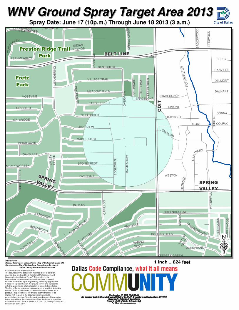
Spray Date: June 17 (10p.m.) Through June 18 2013 (3 a.m.)
Fretz
Park
Preston Ridge Trail
Park
TOPHILL
ELMRIDGE
ED
GE
CR
ES
T
RE
GE
NC
Y
HA
YM
EA
DO
W
VA
LL
EY
CR
EE
K
ROLLING HILLS
LAMP POST
BR
OO
KC
RE
ST
WESTON
DUMONT
CO
TT
ON
WO
OD
DO
GW
OO
D
FAR HILLS
GREENHOLLOW
BR
OO
KW
OO
D
CAVALIER
KEEPERS GREEN
CA
RR
IAG
E
SP
RIN
G C
RE
EK
STAGECOACH
WA
TE
RF
AL
L
ME
AN
DE
RIN
G
LEAMEADOWCHATTINGTON
RAMP
TANGLECREST
REGAL
FERNMEADOW
SA
PL
ING
BIR
CH
RID
GE
RA
MB
LE
WO
OD
MOSSYBANK
WIL
LOW
BE
NDK
NO
LLWO
OD
LYNWORTH
MEADOWCREEK
OAKBLUFF
ASHRIDGE
DU
BL
IN
BARCELONA
PALDAO
MEAN
DER
ING
ST
ON
EM
OS
S
LARCHVIEW
ALLE
G
HENY
OV
ER
VIE
W
MAPLECREST
MIDCREST
TA
NG
LE
GLEN
BIRCHWOOD
MOSSVINE
GATERIDGE
CLIFFBROOK
BRIAR COVE
CA
RIL
LO
N
COLFAX
DONNA
DELMONT
DALHART
DANVILLE
DERBY
VILLAGE TRAIL
MEADOWHAVEN
SPRUCEWO
OD
STONECREST
OVERDALE
DE
L P
RA
DO
LA
S F
LO
RE
S
RE
FO
RM
A
DENTCREST
CLEARSPRINGS
PEYTON
SPRING
GROVE
ACRES
INDIAN
SPRINGS
BELT LINE
SPRING VALLEYSPRING
VALLEY
CO
IT
WNV Ground Spray Target Area 2013WNV Ground Spray Target Area 2013
Data Source:Roads, Waterways, Lakes, Parks - City of Dallas Enterprise GISSpray Areas - City of Dallas Code Compliance Services & Dallas County Environmental Services
City of Dallas GIS Map Disclaimer:The accuracy of this data within this map is not to be taken /used as data produced by a Registered Professional LandSurveyor for the State of Texas.* ‘This product is forinformational purposes and may not have been preparedfor or be suitable for legal, engineering, or surveying purposes.It does not represent an on-the-ground survey and representsonly the approximate relative location of property boundaries.The City of Dallas makes no representation of any kind, including,but not limited to, warranties of merchantability or fitness for a
particular purpose or use, nor are any such warranties to beimplied with respect to the accuracy information/datapresented on this map. Transfer, copies and/or use of informationin this map without the presentation of this disclaimer is prohibited.City of Dallas GIS* State of Texas: H.B. 1147 (W. Smith) – 05/27/2011,Effective on 09/01/2011
·1 inch = 824 feet
Monday, June 17, 2013 10:52:59 AMMonday, June 17, 2013 10:52:59 AMMonday, June 17, 2013 10:52:59 AMMonday, June 17, 2013 10:52:59 AMFile Location: U:\Code\MosquitoOngoing2013\2013-04-25_KT_GroundSprayNotificationMaps_WNV2013File Location: U:\Code\MosquitoOngoing2013\2013-04-25_KT_GroundSprayNotificationMaps_WNV2013File Location: U:\Code\MosquitoOngoing2013\2013-04-25_KT_GroundSprayNotificationMaps_WNV2013File Location: U:\Code\MosquitoOngoing2013\2013-04-25_KT_GroundSprayNotificationMaps_WNV2013
Prepared By: Dallas Code CompliancePrepared By: Dallas Code CompliancePrepared By: Dallas Code CompliancePrepared By: Dallas Code ComplianceProperty of: City of Dallas Enterprise GISProperty of: City of Dallas Enterprise GISProperty of: City of Dallas Enterprise GISProperty of: City of Dallas Enterprise GIS
For illustrative purposes only.For illustrative purposes only.For illustrative purposes only.For illustrative purposes only.

1 inch = 824 feet
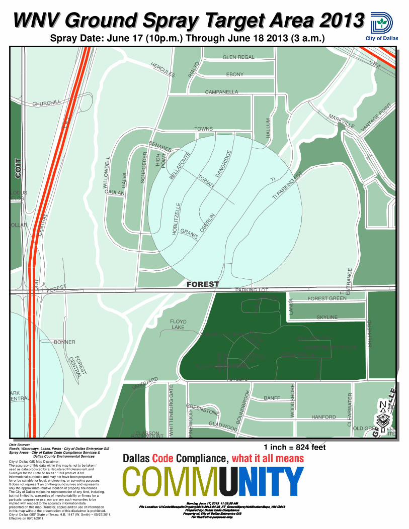
Spray Date: June 17 (10p.m.) Through June 18 2013 (3 a.m.)
Crawford Memorial
Kensington
Park
Grove Oaks
Park
ttu175
ACONDA
HAMLIN
HALONA
LONDENBERRY
CA
MP
US
CR
US
AD
ER
CASSIDY
PL
EA
SA
NT
HIL
LS
RED
PLEASANT
UA
RD
PLEASANT VISTA
LE
VA
NT
BU
TT
ER
CU
P
STEBBINS
SUNBURST
CE
NT
EN
NIA
L
ST AUGUSTINE
GRADY
GROVE OAKS
OLD SEAGOVILLE
PEBBLE VALLEY
MA
ST
ER
S
TR
EG
O
HGATE
BA
YS
HO
RE
NA
CH
ITA
AN
CE
ST
RY
SQ
U
BEAUTYC
REST
HERITAGE ES
TE
RIN
E
CUSHING
LE
GA
CY
CHESAPE
EDNA
MIR
RO
R L
AK
E
PL
EA
SA
NT
WO
OD
S
ORINOCO
PRAIRIE OAK
MO
SS
RO
SE
SCHOONER
WESSEX
CARAVELLE
YA
RR
OW
MILL VALLEY
CUBA
MIAMI
LANSDOWNE
AP
AC
HE
KO
DIA
KO
LD
MIL
L
CRICKET
CR
EN
SH
AW
FAIRHOPE
SILVER FALLS
CASNETT
KINSLOW
TRAIL
SE
PT
EM
BE
R
BE
AC
ON
HIL
L
MA
RK
S
BOSTON
CANDLEWOOD
EVERTON
SEAGOVILLE
PR
AIR
IE V
IST
A
PR
AIR
IE G
RO
VE
VIS
TA
DE
LP
HIN
IUM
HARVEST
C F HAWN
OLD SEAGOVILLECUSHING
ST
AU
GU
ST
INE
ELAM
MA
ST
ER
S
WNV Ground Spray Target Area 2013WNV Ground Spray Target Area 2013
Data Source:Roads, Waterways, Lakes, Parks - City of Dallas Enterprise GISSpray Areas - City of Dallas Code Compliance Services & Dallas County Environmental Services
City of Dallas GIS Map Disclaimer:The accuracy of this data within this map is not to be taken /used as data produced by a Registered Professional LandSurveyor for the State of Texas.* ‘This product is forinformational purposes and may not have been preparedfor or be suitable for legal, engineering, or surveying purposes.It does not represent an on-the-ground survey and representsonly the approximate relative location of property boundaries.The City of Dallas makes no representation of any kind, including,but not limited to, warranties of merchantability or fitness for a
particular purpose or use, nor are any such warranties to beimplied with respect to the accuracy information/datapresented on this map. Transfer, copies and/or use of informationin this map without the presentation of this disclaimer is prohibited.City of Dallas GIS* State of Texas: H.B. 1147 (W. Smith) – 05/27/2011,Effective on 09/01/2011
·1 inch = 824 feet
Monday, June 17, 2013 11:09:50 AMMonday, June 17, 2013 11:09:50 AMMonday, June 17, 2013 11:09:50 AMMonday, June 17, 2013 11:09:50 AMFile Location: U:\Code\MosquitoOngoing2013\2013-04-25_KT_GroundSprayNotificationMaps_WNV2013File Location: U:\Code\MosquitoOngoing2013\2013-04-25_KT_GroundSprayNotificationMaps_WNV2013File Location: U:\Code\MosquitoOngoing2013\2013-04-25_KT_GroundSprayNotificationMaps_WNV2013File Location: U:\Code\MosquitoOngoing2013\2013-04-25_KT_GroundSprayNotificationMaps_WNV2013
Prepared By: Dallas Code CompliancePrepared By: Dallas Code CompliancePrepared By: Dallas Code CompliancePrepared By: Dallas Code ComplianceProperty of: City of Dallas Enterprise GISProperty of: City of Dallas Enterprise GISProperty of: City of Dallas Enterprise GISProperty of: City of Dallas Enterprise GIS
For illustrative purposes only.For illustrative purposes only.For illustrative purposes only.For illustrative purposes only.
1 inch = 824 feet
Spray Date: June 17 (10p.m.) Through June 18 2013 (3 a.m.)
CLASSON
GA
LVA
STULTS
BONNER
CO
IT
SC
HR
OE
DE
R
LA
ND
APARKING LOT
WHITEH
SH
EP
HE
RD
VANGUARD
BRUSH ARBO
R
ROCKMOUNT WH
ITT
EN
BU
RG
GA
TE
BO
UN
DB
RO
OK
CL
EA
RW
AT
ER
EBONY
GLEN REGAL
BUGLE
HIG
H P
OIN
T
TI PAR
KING
LOT
CAMPANELLA
PIN
EW
OO
D
HA
LL
UM
GREEN
TOWNS
GRANIS
GREENSTONE
CAULAN
TOBIAN
WO
OD
SH
OR
E
CE
NT
RA
L
GREENHOUSE
GAZEBO
WESTMINSTER
CLODUS IELDS
DOLLAR
ALEXANDER WOODS
CHURCHILL
VANTA
GE
POIN
T
FOREST
AN
GL
IN
TI
EN
TR
AN
CE
ANDERSON CREEK
PARK
CENTRAL
CANTERBURY FIELDS
HERCULES
LEONARD ROSE
BANFF
BENARES
L B J
MARKVILLE
OLD GREENVILLE
WE
SL
EY
RIA
LTO
SKYLINE
FOREST GREEN
BE
LLA
FO
NTE
FO
RE
ST
CE
NT
RA
L
HANFORD
GLADWOOD
TI
DA
ND
RID
GE
OB
ER
LIN
L B
J
VIL
LA
GE
FO
RE
ST
FLOYD LAKE
WIL
LO
WD
EL
L
HO
BL
ITZ
EL
LE
FOREST
COIT
GREENVILLE
WNV Ground Spray Target Area 2013WNV Ground Spray Target Area 2013
Data Source:Roads, Waterways, Lakes, Parks - City of Dallas Enterprise GISSpray Areas - City of Dallas Code Compliance Services & Dallas County Environmental Services
City of Dallas GIS Map Disclaimer:The accuracy of this data within this map is not to be taken /used as data produced by a Registered Professional LandSurveyor for the State of Texas.* ‘This product is forinformational purposes and may not have been preparedfor or be suitable for legal, engineering, or surveying purposes.It does not represent an on-the-ground survey and representsonly the approximate relative location of property boundaries.The City of Dallas makes no representation of any kind, including,but not limited to, warranties of merchantability or fitness for a
particular purpose or use, nor are any such warranties to beimplied with respect to the accuracy information/datapresented on this map. Transfer, copies and/or use of informationin this map without the presentation of this disclaimer is prohibited.City of Dallas GIS* State of Texas: H.B. 1147 (W. Smith) – 05/27/2011,Effective on 09/01/2011
·1 inch = 824 feet
Monday, June 17, 2013 11:05:58 AMMonday, June 17, 2013 11:05:58 AMMonday, June 17, 2013 11:05:58 AMMonday, June 17, 2013 11:05:58 AMFile Location: U:\Code\MosquitoOngoing2013\2013-04-25_KT_GroundSprayNotificationMaps_WNV2013File Location: U:\Code\MosquitoOngoing2013\2013-04-25_KT_GroundSprayNotificationMaps_WNV2013File Location: U:\Code\MosquitoOngoing2013\2013-04-25_KT_GroundSprayNotificationMaps_WNV2013File Location: U:\Code\MosquitoOngoing2013\2013-04-25_KT_GroundSprayNotificationMaps_WNV2013
Prepared By: Dallas Code CompliancePrepared By: Dallas Code CompliancePrepared By: Dallas Code CompliancePrepared By: Dallas Code ComplianceProperty of: City of Dallas Enterprise GISProperty of: City of Dallas Enterprise GISProperty of: City of Dallas Enterprise GISProperty of: City of Dallas Enterprise GIS
For illustrative purposes only.For illustrative purposes only.For illustrative purposes only.For illustrative purposes only.