woodlot licence w0037 - university of british … licence w0037 ... the university of british...
TRANSCRIPT

Woodlot Licence W0037 – DRAFT WLP #1
2013/08/21 Page 1 of 25
WOODLOT LICENCE # W0037
DRAFT WOODLOT LICENCE PLAN #1
First Term 2013 to 2023
The University of British Columbia Malcolm Knapp Research Forest PO Box 21120 RPO Square Maple Ridge, BC V2X 1P7 E-mail: [email protected] Phone: 604-463-8148 Fax: 604-463-2712
Authorized Licensee Signature: ____________________________ Print Name: ____________________________ Date: ____________________________ District Manager Signature: ____________________________ Print Name: ____________________________ Date: ____________________________

Woodlot Licence W0037 – DRAFT WLP #1
2013/08/21 Page 2 of 25
DISCLAIMER Recognizing the special nature of management on a woodlot licence, this disclaimer forms part of the Woodlot Licence Plan (WLP) for Woodlot Licence W0037 and advises that:
the decision to operate under one or more of the Default Performance Requirements provided in the Woodlot Licence Planning and Practices Regulation (WLPPR) is the sole responsibility of the woodlot licence holder, and involved no detailed oversight or advice from the prescribing registered professional forester. This disclaimer is signed on the explicit understanding and information provided by government that, the use and achievement of a Default Performance Requirement, meets the expectations of government with respect to the management of woodlot licences;
the undersigned Registered Professional Forester has been retained to provide advice on the practice of professional forestry with regard to items such as alternative performance requirements, applicable results and strategies and other required measures that do not have a default performance requirement provided in the WLPPR.
Signed ____________________________________________________ Name (Print): Cheryl Power, RPF RPF #: 2166 Contact phone number: 604-463-8148 Email: [email protected] Seal:

Woodlot Licence W0037 – DRAFT WLP #1
2013/08/21 Page 3 of 25
TABLE OF CONTENTS
INTRODUCTION............................................................................................................. 4
I. CONTENT FOR A WOODLOT LICENCE PLAN (WLP) .................................... 5
PLAN AREA ..................................................................................................................... 5
MAP AND INFORMATION ........................................................................................... 5
AREAS WHERE TIMBER HARVESTING WILL BE AVOIDED ........................... 9
AREAS WHERE TIMBER HARVESTING WILL BE MODIFIED ......................... 9
CONSERVING AND PROTECTING CULTURAL HERITAGE RESOURCES .. 10
WILDLIFE TREE RETENTION STRATEGY .......................................................... 12
MEASURES TO PREVENT INTRODUCTION OR SPREAD OF INVASIVE PLANTS ........................................................................................................................... 14
STOCKING INFORMATION FOR SPECIFIED AREAS ........................................ 15
PERFORMANCE REQUIREMENTS ......................................................................... 15
SOIL DISTURBANCE LIMITS ...............................................................................................................15 PERMANENT ACCESS STRUCTURES ................................................................................................15 STOCKING STANDARDS .....................................................................................................................16 WIDTH OF STREAM RIPARIAN AREAS .............................................................................................16 WIDTH OF WETLAND RIPARIAN AREAS .........................................................................................17 WIDTH OF LAKE RIPARIAN AREAS ..................................................................................................17 RESTRICTIONS IN A RIPARIAN RESERVE ZONE ............................................................................17 RESTRICTIONS IN A RIPARIAN MANAGEMENT ZONE .................................................................17 WILDLIFE TREE RETENTION ..............................................................................................................17 COARSE WOODY DEBRIS ...................................................................................................................17 RESOURCE FEATURES ........................................................................................................................18
APPENDICES ................................................................................................................. 19
Woodlot Licence W0037 – DRAFT WLP #1
2013/08/21 Page 4 of 25
INTRODUCTION Woodlot Licence W0037 is located in the City of Pitt Meadows, in the Chilliwack Forest District, 60 km east of Vancouver. The total woodlot area is 297.2 ha, of which 277.7 ha is Schedule B (Crown) land, and 19.5 ha is Schedule A (private) land. The woodlot area also encompasses a BC Hydro Right-of-Way, representing a 30 ha (approx.) reduction to the total woodlot area. The Woodlot Licence is held by the University of British Columbia, and has been managed by the UBC Malcolm Knapp Research Forest since 1987. The management objectives for Woodlot Licence W0037 are diverse, due to the goals of the Licensee and the nature of the land and surrounding community. The topography, forest cover, and natural resource values are diverse. The goal of the Licensee is to manage a section of Crown land for ecologically sustainable timber production, while protecting and conserving non-timber values including recreation, education, research, scenic quality, water and soil resources, cultural heritage, wildlife habitat and biodiversity. In recognition of aboriginal interests, rights and title, the Licensee is fully committed to working closely with applicable First Nations in protecting cultural heritage values as part of its management practices. Based on information supplied by the Ministry of Forests, Lands and Natural Resource Operations, the Woodlot Licence is known to be within the traditional territory of the following First Nations:
Katzie First Nation Seabird Island First Nation Skawahlook First Nation Sto:lo Nation Sto:lo Tribal Council Tsawwassen First Nation.
Most of the Woodlot Licence is immature and mature second growth Douglas-fir, western hemlock, and western redcedar mixtures dating from the 1868 fire. Scattered old growth Douglas-fir veterans occur, as well as second growth stands from logging as early as the 1960’s. Deciduous trees are common along streams and near wetlands. The Woodlot Licence contains two lakes, a major BC Hydro Right-of-Way, a designated recreation area, and overlaps with a Wildlife Management Area. It also surrounds a 17 ha (approx.) private land parcel which is not part of the woodlot. Much of the woodlot is on steep terrain and includes Scenic Areas subject to Visual Quality Objectives1. The management of Woodlot Licence W0037 and this Woodlot Licence Plan are governed by the Woodlot Licence Planning and Practices Regulation and also conform to the Forest and Range Practices Act SBC 2002 (c. 69)(both current to June 26, 2013).
1 Visual Quality Objectives define the level of management appropriate for different Scenic Areas (http://www.for.gov.bc.ca/hfp/frep/values/visual.htm).

Woodlot Licence W0037 – DRAFT WLP #1
2013/08/21 Page 5 of 25
I. CONTENT FOR A WOODLOT LICENCE PLAN (WLP) PLAN AREA
This plan covers the entire Woodlot Licence area.
This plan covers a portion of the Woodlot Licence area.
MAP AND INFORMATION
Information Item Map Text N/A
Forest cover Topography; (unless exempted by DM) Location of streams, wetlands and lakes as shown on forest cover maps, terrain resource inventory maps and fish and fish habitat inventory maps
Riparian classification of streams, wetlands and lakes if shown on maps
Identification of fish streams Biogeoclimatic zones and subzones (unless exempted by DM) Public utilities (transmission lines, gas & oil pipelines, and railways)
Existing roads Special Situations that may not Apply to the Woodlot Licence area Resource Management Zones, Landscape Units or Sensitive Areas
Wildlife Habitat Areas (unless exempted by DM) Scenic Areas Ungulate Winter Ranges Community Watersheds Fisheries Sensitive Watersheds Community and domestic water supply intakes that are licensed under the Water Act and any related water supply infrastructures
Contiguous areas of sensitive soils Temporary or permanent barricades to restrict vehicle access Private property within or adjacent to the Woodlot Licence area Resource features other than wildlife habitat features and archaeological sites (unless the location of the resource feature is not to be disclosed)

Woodlot Licence W0037 – DRAFT WLP #1
2013/08/21 Page 6 of 25
Biogeoclimatic zones and subzones: The entire Woodlot Licence area is in the CWHdm (Coastal Western Hemlock dry maritime) biogeoclimatic subzone.
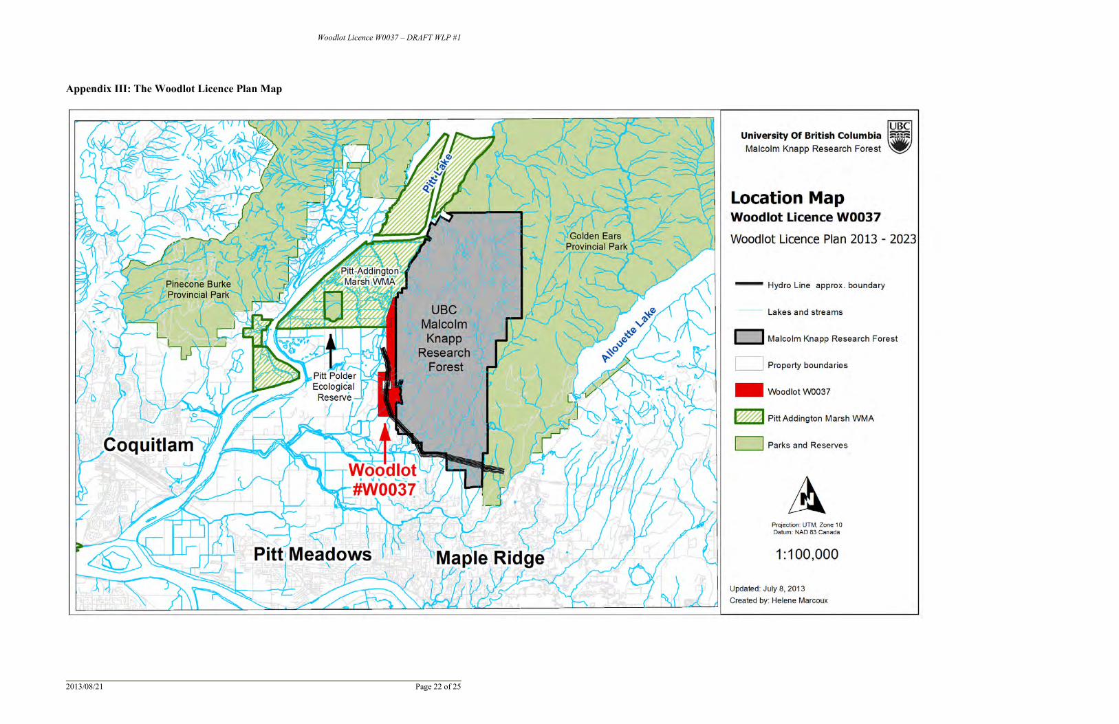
Resource Management Zones, Landscape Units or Sensitive Areas: The entire Woodlot Licence area is within the Widgeon Landscape Unit of the Chilliwack Forest District. A 37.2 ha Crown land portion at the northern end of the Woodlot overlaps the Pitt-Addington Marsh Wildlife Management Area, which was established under the Land Act just prior to the designation of Woodlot W0037 in 1987. This overlap area is identified on the map in Appendix III. Land use objectives, established by the Ministry of Environment, will be addressed by designating the entire overlap as an “Area Where Harvesting Will Be Avoided”. Since 2001, the 11.9 ha Goose Lake Subcompartment (surrounding the western side of Goose Lake) has been included as part of Woodlot W00372, as identified in Appendix III. Prior to this date, the Goose Lake Subcompartment was designated as a recreation reserve (formerly UREP #0142597) under the Land Act. Given this previous designation, management of this subcompartment has and will continue to be consistent with its original mandate as an “Area Where Harvesting Will Be Avoided”. No harvesting operations will take place within the subcompartment; however, site specific actions (e.g., tree removal or falling) may be required to address forest health issues, spread of forest pest outbreaks, danger trees safety concerns or increased fire hazard from fuel-buildup. No other parts of Woodlot Licence #W0037 are within a Resource Management Zone, Landscape Unit, or Sensitive Area, as designated by the Province of British Columbia.
Wildlife Habitat Areas: No designated Wildlife Habitat Areas have been identified in Woodlot Licence W0037 as designated under the Government Actions Regulation.
Scenic Areas: Scenic areas have been established within the Woodlot Licence area as identified on the map in Appendix III. These include polygons #729, 730, 733, 736, 737. Harvesting in
2 Madularu, A. 2000. Management statement for Goose Lake Recreational Reserve (UREP #0142597) as part of Woodlot Licence #W0037. UBC Malcolm Knapp Research Forest. Approved by Chilliwack District Manager on Aug. 2, 2001.
Woodlot Licence W0037 – DRAFT WLP #1
2013/08/21 Page 7 of 25
scenic areas will be modified according to Visual Quality Objectives designated by the Ministry of Forests, Lands and Natural Resource Operations.
Ungulate Winter Ranges: No known Ungulate Winter Range Areas have been established over the Woodlot Licence area.
Community Watersheds: There are no known Community Watersheds designated within the Woodlot Licence area.
Fisheries Sensitive Watersheds: There are no known Fisheries Sensitive Watersheds designated within the Woodlot Licence area.
Community and domestic water supply intakes that are licensed under the Water
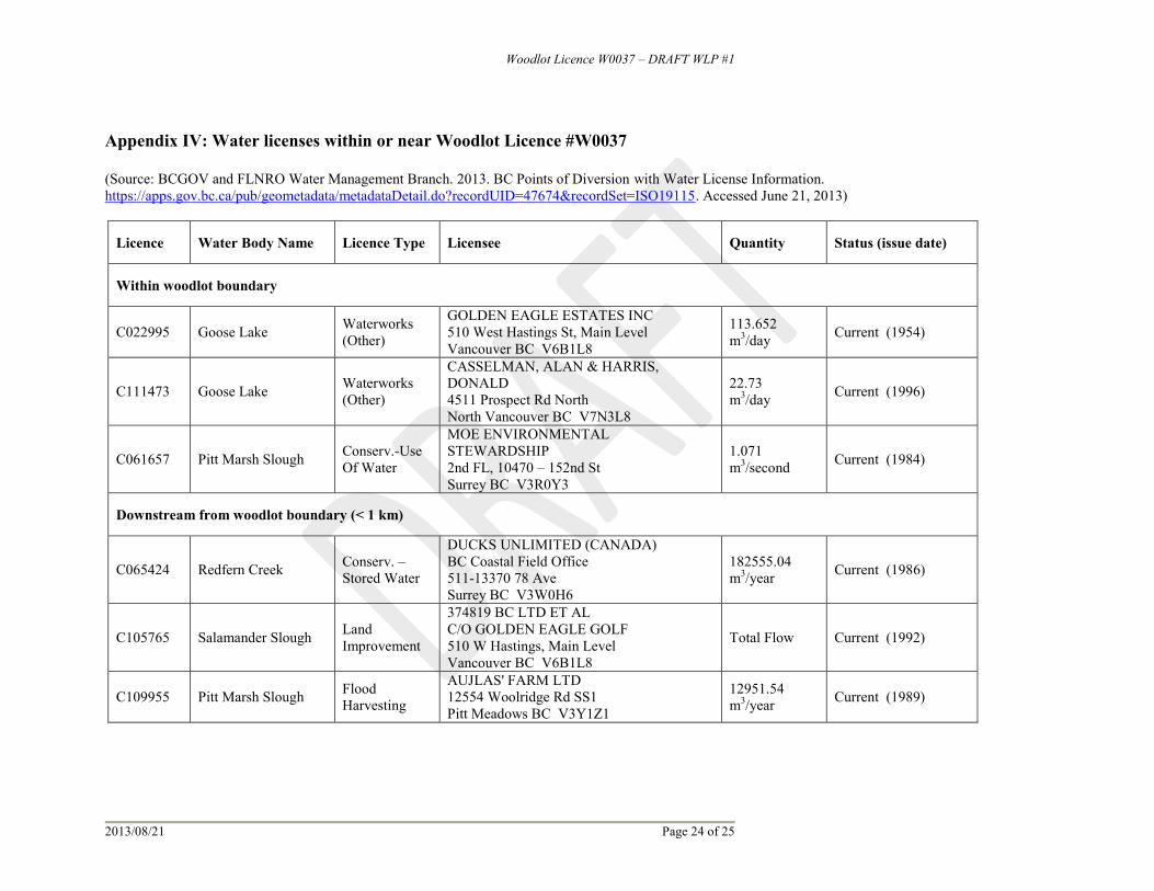
Act and any related water supply infrastructures: There are no known Community or Domestic water supply intakes and any related water supply infrastructures that are licenced under the Water Act within the area of Woodlot W0037. The Woodlot Licence area contains three active water licences with intake locations shown on the map in Appendix III. Two active licences are located on Goose Lake, one within the Goose Lake Subcompartment and the second on the east side of the lake and both are licensed for “Waterworks (Other)”. A third active water licence is located in the Pitt-Addington Marsh Wildlife Management Area (north portion of Woodlot Licence area) and is licensed by the Ministry of Environment, Environmental Stewardship for “Conservation, Use of Water”. In addition, three active licences are located within 1 km downstream from the woodlot boundary, two of which are shown on the map in Appendix III. In all cases, riparian management areas will be used to address water related concerns within and downstream from the woodlot area. Details pertaining to each water licence located within the woodlot and less than 1 km downstream from the woodlot boundary are listed in Appendix IV.
Woodlot Licence W0037 – DRAFT WLP #1
2013/08/21 Page 8 of 25
Contiguous areas of sensitive soils: “Sensitive soil” is defined in Section 1(2) of the WLPPR as an area with one or both of the following:
(a) a slope greater than 60% (b) indicators of potential slope instability.
Contiguous areas of sensitive soils that the Woodlot Licence holder is aware of are indicated on the map in Appendix III. These represent areas > 60% slope based on analysis of TRIM3 topographic data. Soils in these areas may be thinner and sensitive to forest floor displacement, or terrain instability. Further terrain stability and forest soil field assessments will be carried out during cutblock planning and will likely modify the current mapped areas of sensitive soils as found in Appendix III.
Temporary or permanent barricades that restrict vehicle access: At the time of preparing this Woodlot Licence Plan there are no permanent or temporary barricades on the Woodlot Licence area to restrict vehicle access. Vehicle access to the Woodlot Licence is only from the east side, through the UBC Malcolm Knapp Research Forest. The Research Forest is a restricted vehicle access area, with a permanent gate located at the main entrance at 14500 Silver Valley Road, approximately 5.5 km from the Woodlot Licence. Old roads from the south and west are abandoned and have not been used for vehicle access in recent decades.
Private property within or adjacent to the Woodlot Licence area: The Woodlot Licence surrounds a 17 ha (approximate size) parcel of private land. This parcel and adjacent private properties are shown on the map in Appendix III. Ongoing consultation will occur to ensure activities and treatments are co-ordinated between crown and private property interests. The Woodlot Licence area also includes a BC Hydro Right-of-Way, covering an area of approximately 30 ha. Although not private property, this Right-of-Way places major constraints on compatible uses. Furthermore, timber rights within the Right-of-Way are also excluded from the Woodlot License.
3 The Terrain Resource Inventory Management (TRIM) program creates topographic mapsheets for the whole province.

Woodlot Licence W0037 – DRAFT WLP #1
2013/08/21 Page 9 of 25
Resource features other than wildlife habitat features and other features where the location must not be disclosed: At the time of preparing this Woodlot Licence Plan, no resource features have been established within the Woodlot Licence area under the Government Actions Regulation.
AREAS WHERE TIMBER HARVESTING WILL BE AVOIDED Timber harvesting will be avoided in a 37.5 ha area at the north end of the Woodlot Licence which overlaps the Pitt-Addington Marsh Wildlife Management Area. This area is identified on the map in Appendix III and represents 12.6 % of the total Woodlot Licence area. Timber harvesting will also be avoided in the 11.9 ha Goose Lake Subcompartment on the west side of Goose Lake. This area is identified on the map in Appendix III and represents 4 % of the total Woodlot Licence area.
AREAS WHERE TIMBER HARVESTING WILL BE MODIFIED Timber harvesting will be modified in the following areas:
Wildlife Tree Retention Areas Areas > 60% slopes with sensitive soils Scenic Areas (in accordance with Visual Quality Objective of the Chilliwack
Forest District) Riparian Reserve Zones* Riparian Management Zones*
The location of these areas is shown on the Woodlot Licence Plan Map in Appendix III. *Note: Riparian Reserve Zones and Riparian Management Zones are shown on the Map in Appendix III for lakes, wetland and streams that have been classified on government-endorsed maps4 or through previous field-based stream assessments5. Any streams which are not currently classified will be assessed prior to future forest management operations and appropriate Riparian Reserve Zones and/or Riparian Management Zones will be established as required and described in “PERFORMANCE REQUIREMENTS” section of this plan.
4 Government-endorsed maps include Terrain Resource Inventory Management maps, and Fish Inventory Maps. 5 A fish-stream identification and stream classification survey was conducted in 2002 by Ellis Environmental Consultants on Mackenzie Creek.

Woodlot Licence W0037 – DRAFT WLP #1
2013/08/21 Page 10 of 25
Riparian Management Zones Unless exempted by the district manager, or the harvesting of a road clearing width is required, the Woodlot Licence holder is committed to retaining the following post harvest stand structure in riparian management zones:
1) The minimum percentage of the total basal area within the riparian management zone (specified in column 2 of Table 1) will be left as standing trees at the completion of harvesting:
Table 1: Minimum basal area retained in Riparian Management Zones vary depending on the Riparian Class of each stream.
Riparian Class6
Minimum Basal Area (m2/ha) to be Retained
Within Riparian Management Zone (%)
S1-A or S1-B stream > 20 S2 stream > 20 S3 stream > 20 S4 stream > 10 S5 stream > 10 S6 stream > 5 All classes of wetlands or lakes > 10
2) To extent practicable, the Woodlot Licence holder will ensure that trees retained
in the riparian management zone are reasonably representative of the spatial distribution and range of sizes of trees as found before harvesting. However, ensuring safety and a windfirm stand post-harvest are of primary consideration.
CONSERVING AND PROTECTING CULTURAL HERITAGE RESOURCES Strategies to conserve and protect Cultural Heritage Resources have and will continue to be developed based on information obtained from First Nations whose traditional territory overlaps with Woodlot W0037. Discussions with the Katzie First Nation have been ongoing over many years, and are expected to continue. Discussions with other First Nations have been limited to date, but are welcomed at any time. The following strategy (Table 2) is proposed to conserve and protect cultural heritage resources that are the focus of a traditional use by an aboriginal people and of continuing importance to them. This strategy applies to cultural heritage resources but does not include archaeological sites, which are specifically protected under the Heritage Conservation Act.
6 Riparian classes as defined by Woodlot Licence Planning and Practice Regulation, WLPPR s. 36, 37 and 38.
Woodlot Licence W0037 – DRAFT WLP #1
2013/08/21 Page 11 of 25
Table 2: Proposed results and strategies for conserving and protecting cultural heritage values.
Cultural Heritage Values
Western Redcedar (Cw)
Result Enable access to Cw for traditional use by local First Nations.
Strategies When requested by local First Nations, access opportunities for traditional use of Cw will be provided within an agreed upon area and timeframe.
Long term supply of western redcedar will be ensured by:
o Planting Cw on sites where it is an ecologically acceptable species, but subject to the availability of suitable seedling stock.
o Retaining healthy naturally occurring young Cw trees (regeneration, saplings and non-merchantable poles) where operationally feasible.
Traditional Use Plants (other than cedar)
Result Enable continued access to traditionally used plants by local First Nations.
Strategies When interest in specific traditional use plants is indicated by local First Nations, the Licensee will examine planned harvest areas for their presence and notify the interested First Nations prior to cutting permit submission.
o Reasonable opportunity will be given to the applicable First Nations to review cutting permits and to collect traditional use plants prior to harvest.
A no-pesticide policy has been adopted in this Woodlot Licence and is replaced by manual brushing and early planting of suitable stock to mitigate brush problems affecting tree seedling survival.
New Information on Cultural Heritage Resources
Result Consider and make reasonable attempt to include any new cultural heritage resources information in harvest and management plans.
Strategies The Licensee will be vigilant in looking for evidence of cultural heritage resources during fieldwork and will notify First Nations and the Forest District if any evidence is discovered.
If evidence of a previously unidentified cultural resource feature is discovered while carrying out a forest practice, all activities that threaten the site will be suspended immediately.
The Licensee will promptly advise the MoFLNR7 and the local First Nations of the existence of any newly identified sites or features, and will co-operate fully in consultations and comply with the directions of the Aboriginal Liaison Officer of the MoFLNR.
The Licensee will share information with local First Nations upon request and will be available for meetings and field reviews.
7 Ministry of Forest, Lands and Natural Resource Operations.
Woodlot Licence W0037 – DRAFT WLP #1
2013/08/21 Page 12 of 25
Additional Considerations Recommendations by a previous Archaeological Overview Assessment conducted in the woodlot8 will be considered during operational planning. In the case of archaeological sites within the Woodlot Licence, the licensee will comply with the requirements of the Heritage Conservation Act and other relevant legislation, and is aware of the need to ensure that archaeological sites are properly managed and protected from disturbance. Aboriginal title and treaty issues are evolving, and for the purposes of the Woodlot Licence are in the jurisdiction of the government and in particular the Ministry of Forests, Lands and Natural Resource Operations (MoFLNR). These issues will be referred to the MoFLNR District Office for advice and guidance. The Licensee also acknowledges that future court decisions may affect the duties of government to consult and accommodate First Nations and that this in turn may affect current and future Woodlot Licence Plans.
WILDLIFE TREE RETENTION STRATEGY Note: the proportion of the Woodlot Licence area that is occupied by wildlife tree retention areas is specified in the “PERFORMANCE REQUIREMENTS” section of this plan. INDIVIDUAL WILDLIFE TREES a) Species and Characteristics:
Preferred species: Douglas-fir
Acceptable species: Any other native species occurring on the Woodlot Licence area including western redcedar, western hemlock, grand fir, Sitka spruce, bigleaf maple, paper birch, red alder
Preferred age / size class: Large old growth (veteran) Douglas-fir > 1m DBH (diameter at breast height)9
Acceptable age / size class: Mature or old growth trees of large size for their species and height
Preferred characteristics (all species): Evidence of active or recent wildlife use (e.g. nest or den); Attributes such as internal decay, dead top, large limbs or brooms, or dead trees; Windfirm (i.e., large and stable); Safe to work around for current and near future forest operations.
8 Hoffmann, T. 2003. UBC Malcolm Knapp Research Forest Woodlot Licence W0037: Archaeological Overview Assessment. On file with the UBCMKRF. 9 DBH = diameter at breast height

Woodlot Licence W0037 – DRAFT WLP #1
2013/08/21 Page 13 of 25
b) Conditions Under Which Individual Wildlife Trees May Be Removed: Individual wildlife trees may be removed if an assessment determines they have become a safety hazard, or if they become infested with insects or diseases which threaten the health of adjacent trees. c) Replacement of Individual Wildlife Trees: If individual wildlife trees are removed they will be replaced with trees of comparable wildlife tree value from a nearby location within the Woodlot Licence area, if such trees exist.
WILDLIFE TREE RETENTION AREAS a) Forest Cover Attributes: To maintain and promote biodiversity, Wildlife Tree Retention Areas (WTRAs) will include diverse species, age and size classes typical of mature forest in the Woodlot Licence area. WTRAs will also include a significant amount of trees with at least one of the attributes listed above under “INDIVIDUAL WILDLIFE TREES”. An attempt will also be made to select WTRAs based on their potential to develop wildlife tree attributes associated with advanced stand age. WTRAs will be preferentially located in sensitive management areas where harvesting will be avoided or modified. This includes Riparian Reserve Zones, Scenic Areas and the Goose Lake Subcompartment. In addition, a WTRA will be designated in the overlap area with the Pitt-Addington Marsh Wildlife Management Area (37.5 ha), as identified on the map in Appendix III. Combined these areas represent approximately 75% of the Woodlot and encompass a broad range of forest cover attributes. Together, the WTRA Goose Lake Subcompartment (11.9 ha) and the overlap area with the Pitt-Addington Marsh Wildlife Management Area (37.2 ha) represent 16.6% of the total area of the Woodlot Licence, exceeding the default 8% minimum area required under the Woodlot Licence Planning and Practices Regulation. b) Conditions Under Which Trees May Be Removed from Wildlife Tree Retention
Areas: Trees may be removed from most WTRAs to address forest health issues, spread of forest pest outbreaks, danger trees safety concerns or to provide access to adjacent stands (e.g., road or trail construction). However, different conditions apply to WTRAs in the Goose Lake Recreation Reserve where trees may also be removed for fire hazard mitigation purposes. Fire hazard and fire protection are a major concern in this subcompartment given its high public use and
Woodlot Licence W0037 – DRAFT WLP #1
2013/08/21 Page 14 of 25
history of recreationist-caused forest fires10. Consequently, trees may be removed to reduce risk of fire spread in the event of an ignition. No trees will be removed from the WTRA overlapping the Pitt-Addington Marsh Wildlife Management Area, except with the prior agreement of the Ministry of Environment. In the unlikely event that harvest is mutually agreed, trees may be removed if they become a safety hazard, if they become infested with insects or diseases which threaten the health of adjacent trees or in order to construct an access road or trail. If providing access to adjacent stands, the number of wildlife trees removed will be no more than reasonably needed to provide the access. c) Replacement of Trees Removed from Wildlife Tree Retention Areas: In the unlikely event that trees are removed from the Wildlife Tree Retention Area, they will be replaced if necessary to meet a minimum Wildlife Tree Retention Area of 14% of the total area of the Woodlot Licence. Replacement trees will be of comparable wildlife tree value from a nearby location, or trees that will develop good wildlife tree value in the near future if comparable trees are not readily available nearby.
MEASURES TO PREVENT INTRODUCTION OR SPREAD OF INVASIVE PLANTS The invasive plant measures in this Woodlot Licence Plan conform to the Invasive Plant Regulation (B.C. Reg. 18/2004, effective January 31, 2004. The woodlot licensee commits to carrying out the following measures to prevent the introduction and spread of invasive plants that is likely the result of the woodlot licensee’s forest practices: The Woodlot Licensee commits to carrying out the following measures to prevent the introduction and spread of invasive plants that is likely the result of the Licensee’s forest practices:
Seeding areas of new disturbance created by the Licensee (i.e. newly constructed roads, trails, landings, pits, quarries, any roadside work areas or area where there is significant mineral soil exposure resulting from timber harvesting), as soon as practicable, at an acceptable rate, with an appropriate mix of fast growing grasses and legumes (using seed of the grade Canada Common #1 or better);
Seeding any access structures that are deactivated or rehabilitated by the Licenseeas soon as practicable and at an acceptable rate with an appropriate mix of fast growing grasses and legumes (using seed of the grade Canada Common #1 or better);
Minimizing the transport of invasive plant seed by removing invasive plant seeds or vegetative material (e.g. burrs) from the clothing and equipment, and by checking the
10 Three forest fires were caused by recreationists near Goose Lake in August 1995, July 1996 and July 2003. Campfires are left unattended on a regular basis. Thus, fire prevention and suppression activities are a priority for UBCMKRF throughout every fire season.
Woodlot Licence W0037 – DRAFT WLP #1
2013/08/21 Page 15 of 25
undercarriage of the Licensee holder vehicles and removing invasive plant material before leaving an infested area;
Training workers to identify invasive plant species;
Checking for invasive species during routine activities (e.g., surveys, planting, brushing), controlling infestations while they are small and reporting the location of invasive plants to an appropriate agency.
STOCKING INFORMATION FOR SPECIFIED AREAS
Not Applicable. The stocking standards for the purposes of section 12 and 34(3) of the Woodlot Licence Planning and Practices Regulation are deferred at this time as no immediate plans for intermediate cuttings or commercial thinning are anticipated. Should such operations be considered during the term of this plan, site-specific stocking standards will be developed and included as part silvicultural prescriptions and harvest plans.
PERFORMANCE REQUIREMENTS SOIL DISTURBANCE LIMITS
Default WLPPR s.24(1)(b): The Licensee commits to maximum soil disturbance limits of 8% of Net Area to be Reforested, as described in WLPPR s.24(1)(b).
PERMANENT ACCESS STRUCTURES
Default: WLPPR s.25: The maximum area occupied by permanent access structures is as follows:
1. For Cutblocks 5 ha – 7% of the total cutblock area 2. For Cutblocks 5 ha – 10% of the total cutblock area 3. For the Total Woodlot Licence Area – 7% of the total Woodlot Licence area.
Alternative WLPPR s.25:
The Licensee commits to the following maximum areas to be occupied by permanent access structures:
1. For Cutblocks 5 ha – 7% of the total cutblock area 2. For Cutblocks 5 ha – 15% of the total cutblock area 3. For the Total Woodlot Licence Area – 7% of the total Woodlot Licence area.
The 15% maximum area for cutblock < 5 ha is an alternative to the default value as described in the WLPPR s.25. The purpose for this increase is to enable the option to design permanent roads in conjunction with small patch cutting systems, a management
Woodlot Licence W0037 – DRAFT WLP #1
2013/08/21 Page 16 of 25
approach with adequate flexibility required to accommodate various issues and constraints, including (but not restricted to) the following, considerations:
Safety in road and cutblock design, location and layout
Scenic Areas and corresponding Visual Quality Objectives
Steep slopes, sensitive soils or unstable terrain
Water course protection and riparian area management
Wildlife tree retention areas including the Goose Lake subcompartment and Pitt-Addington Marsh Wildlife Management Area
Restrictions due to geographic shape of Woodlot Licence (high edge to interior ratio) and location ofboundaries (e.g., private land, water courses, Goose Lk. subcompartment).
Since patch cutting systems may be designed with small (e.g. < 2 ha) blocks which are dispersed both spatially and temporally, permanent roads through small blocks may be necessary to develop a patch cutting system for a larger area. Proportionally, the impact of a within-block road is greater with smaller blocks; however, as adjacent patches are cut over time, the proportion of total collective cutblock area occupied by permanent access structures is expected to decrease Although this scenario could result in a higher percentage area occupied by permanent access structures in an individual cutblock, the road density in the total Woodlot Licence area will remain within the 7% maximum default value.
STOCKING STANDARDS
Default: WLPPR s.35(1)(b): Adopt the stocking standards, regeneration dates and free growing dates described in the MFR publication “Reference Guide for Forest Development Plan Stocking Standards”, as amended from time to time, that are in place on the commencement date for the area. See http://www.for.gov.bc.ca/hfp/silviculture/stocking_stds.htm
Option: WLPPR s.35(1)(a): Use of the current stocking standards, regeneration
dates and free growing dates described in the MFR publication “Reference Guide for Forest Development Plan Stocking Standards”, the pertinent sections (including footnotes) are shown in Appendix II.
Alternative WLPPR s.35(1)(a): The stocking standards, regeneration dates and free
growing dates are indicated in Appendix IIA.
WIDTH OF STREAM RIPARIAN AREAS
Default WLPPR s.36(4)(b): The minimum width of the riparian reserve zone, riparian management zone and riparian management area are as described in WLPPR s.36(4)(b).

Woodlot Licence W0037 – DRAFT WLP #1
2013/08/21 Page 17 of 25
WIDTH OF WETLAND RIPARIAN AREAS
Default: WLPPR s.37(3)(b) The minimum width of the riparian reserve zone, riparian management zone and riparian management area are as described in WLPPR s.37(3)(b).
WIDTH OF LAKE RIPARIAN AREAS
Default: WLPPR s.38(2)(b) The minimum width of the riparian reserve zone, riparian management zone and riparian management area are as described in WLPPR s.38(2)(b).
RESTRICTIONS IN A RIPARIAN RESERVE ZONE
Default: WLPPR s.39(1) Cutting, modifying or removing trees in a riparian reserve zone is limited to the purposes described in Section 39(1) of the WLPPR. Road construction within a Riparian Reserve Zone as per WLPPR s.39(2.1) is not applicable. No roads are proposed in riparian reserve zones. RESTRICTIONS IN A RIPARIAN MANAGEMENT ZONE
Default: WLPPR s.40(1)(b)(c) or (d) Construction of a road in a riparian management zone is limited to the conditions described is Section 40(1) of the WLPPR without additional conditions to allow road construction being provided in the woodlot licence plan. WILDLIFE TREE RETENTION Unless exempted by the district manager, the proportion of the Woodlot Licence area that will be occupied by wildlife tree retention is:
Default WLPPR s.52(1)(a): % specified for the area in a land use objective
Default WLPPR s.52(1)(c): 8 % of the Woodlot Licence area
Alternative WLPPR s.52(1)(b): 14% of the total Woodlot Licence area
COARSE WOODY DEBRIS The minimum amount of coarse woody debris to be left on areas where there is a requirement to establish a free growing stand is:
Default: WLPPR s.54(1)(b) Area on Coast – minimum retention of 4 logs per ha ≥ 5 m in length and ≥30 cm in diameter at one end.

Woodlot Licence W0037 – DRAFT WLP #1
2013/08/21 Page 18 of 25
RESOURCE FEATURES Unless exempted by the district manager, the woodlot licence holder will
Default WLPPR s.56(1)(b): Ensure that forest practices do not damage or render ineffective a resource feature.
CHIEF FORESTER’S STANDARDS FOR SEED USE The Woodlot Licence holder accepts the default standard as described in the WLPPR s.32. The Chief Forester’s Standards for Seed Use effective on the date of approval of this plan, will be adopted.
*****************************************************************
Woodlot Licence W0037 – DRAFT WLP #1
2013/08/21 Page 19 of 25
APPENDICES Appendix I: Stocking Standards for Specified Areas
This section is intentionally left blank.

Woodlot Licence W0037 – DRAFT WLP #1
2013/08/21 Page 20 of 25
Appendix II: Stocking Standards, Regeneration Dates and Free Growing Dates for Free Growing Stands
These stocking standards, regeneration dates and free growing dates are copied from the Ministry of Forests’ publication, Reference Guide for Forest
Development Plan Stocking Standards and apply for the purposes of section 35(1) (a) of the Woodlot Licence Planning and Practices Regulation to areas harvested under this Woodlot Licence Plan where the establishment of a free growing stand is required under section 29(3) of the Forest and Range Practices
Act.
These stocking standards pertain to Coastal Western Hemlock dry maritime (CWH dm) biogeoclimatic subzone.
Biogeoclimatic Ecosystem
Classification Preferred Species
Acceptable Species
MITD1 TSS MSSpa MSSp
Regen date
FG Date Min. FG Ht by Species
Crop Tree to
Site Series (m) (sph) (sph) (sph) (yrs) (yrs) Species Ht (m) Brush %2
01 Fd Cw Hw Pw See note below 900 500 400 3 8−11
Fd, Hw Pw Cw
3.00 2.50 1.50
See note below
02* Pl Fd 400 200 200 3 8−11
Ss Pw
Fd, Hw Pl
Cw
3.00 2.50 2.00 1.25 1.00
03 Fd Cw Hw 800 400 400 3 8−11
Ss Pw
Fd, Hw Pl
Cw
3.00 2.50 2.00 1.25 1.00
04 Fd Cw Pw 900 500 400 3 8−11 Fd, Hw
Pw Cw
3.00 2.50 1.50
05 Cw Fd Pw Bg Hw 900 500 400 3 8−11
Fd, Hw Bg Pw Cw
4.00 3.50 2.50 2.00
06 Cw Hw Fd 900 500 400 6 11−14 Fd, Hw
Pw Cw
3.00 2.50 1.50
07 Cw Fd Bg Hw 900 500 400 3 8−11
Fd, Hw Bg Pw Cw
4.00 3.50 2.50 2.00
08 Bg Cw 900 500 400 3 8−11 Fd, Hw 4.00

Woodlot Licence W0037 – DRAFT WLP #1
2013/08/21 Page 21 of 25
Bg Pw Cw
3.50 2.50 2.00
09 Cw Bg 900 500 400 3 8−11
Fd, Hw Bg Pw Cw
4.00 3.50 2.50 2.00
10 no conifers - - - - -
11* Pl Cw 400 200 200 3 8−11
Ss Pw
Fd, Hw Pl
Cw
3.00 2.50 2.00 1.25 1.00
12 Cw Hw Pw Ss 800 400 400 3 8−11
Ss Pw
Fd, Hw Pl
Cw
3.00 2.50 2.00 1.25 1.00
13 Bg Cw Fd 900 500 400 3 8−11
Fd, Hw Bg Pw Cw
4.00 3.50 2.50 2.00
14 Bg Cw 900 500 400 3 8−11
Fd, Hw Bg Pw Cw
4.00 3.50 2.50 2.00
15 Cw 800 400 400 3 8−11
Ss Pw
Fd, Hw Pl
Cw
3.00 2.50 2.00 1.25 1.00
1Minimum Inter-tree Distance (MITD) =1.6 meters for planting on hygric, sub-hydric or mechanically site prepared areas; and 2.0 meters on all other areas (except those areas where site factors or objectives require a different minimum inter-tree distance. 2 The Crop Tree to Brush % = 150 % for all species. * Reference guide to stocking standards recommends avoiding logging but is included in this table in instances where the site series may be impacted and the Licence holder chooses to regenerate.
Regen date = Regeneration Date FG Date = Free Growing Date
MITD = Minimum distance between well spaced trees of the preferred and acceptable species
Crop Tree to Brush % = the height of free growing trees relative to the competing vegetation within a 1 m radius cylinder around the tree.
Bg = grand fir (Abies grandis) Cw = western red cedar (Thuja plicata) Fd = Douglas-fir (Pseudotsuga menziesii) Hw = western hemlock (Tsuga heterophylla) Pl = lodgepole pine (Pinus contorta) Pw = western white pine (Pinus monticola) Ss = Sitka spruce (Picea sitchensis)
TSS = Target Stocking Standard (sph = healthy well spaced trees / ha)
MSSpa = Minimum Stocking Standard of well spaced trees of preferred and acceptable species
MSSp = Minimum Stocking Standard of well spaced trees of preferred species
Woodlot Licence W0037 – DRAFT WLP #1
2013/08/21 Page 22 of 25
Appendix III: The Woodlot Licence Plan Map

ÑÒ
ÑÒ
!!2
!!2
!!2!!2!!2!!2!!2!!2!!2!!2!!2
!!2
!!2
1FdcHwDr(Cw)
747-24
2FdcCw(Dr)
644-25
3FdcHw(Cw)
536-20
5DrFd(Hw)
336-22
14FdcHw(Cw)
547-23
15FdcHw636-19
22Hw(CwBa)
846-19
25HwCw447-26
26FdcHw646-21
29Fdc
421-11
31FdcCwBa(Hw)325-17
32FdcCwBa(Hw)
645-21
36Fdc
435-20
41FdcCw(Dr)
646-25
49 -
50 -
51Fd(Cw)635-18
53FdHw557-32
54FdHw557-33
57HwFd215-23
58DrHw(Fd)
237-23
64DrMb(CwHw)
337-22
66Fd(Hw)337-28
68Fdc(CwHwDr)
534-22
73CwHw546-26
74HwFdDr224-23
81DrHw(Cw)
226-15
83HwCw234-32
84HwCw(Fd)
236-34
85FdcDr(HwCw)
446-27
86Fdc(HwCw)
655-27
87Fd(HwCw)
862-28
88Fdc(HwCw)
635-19
89FdcDrHwCw
212-22
90FdcHw446-27
91FdcHw(Cw)
646-25
92FdHw(Cw)
446-27
93Mb(HwFd)
328-23
94Fd(Hw)633-19
95 -
96DrFd(Hw)
324-18
97DrHwCw(Mb)
424-19
98Dr(Cw)537-25
99Fdc(Hw)648-25
100Cw(FdcHw)647-23
101FdcDr655-26
102Fd
531-16
103Fdc(HwDr)
644-26
104HwFdc(Cw)
536-18
105FdcHw(CwDr)
747-23
106HwFdc548-21
107FdcHw647-22
108Dr(Fd)424-19
109 -
111FdcHwDr(Cw)
223-22
112Dr(Hw)229-20
113 -
114FdcDr656-26
116Fdc(HwCw)
656-26
123Dr(Fd)336-23
128HwFdCw445-28
134FdMb(Hw)
236-34
142FdcHw(CwDr)
747-23
144Fd(HwDr)
446-29
150Fdc(HwCw)
747-23
155FdcDr
733-17
157FdcHw(Cw)
747-23
158DrHwFdc(Cw)537-18
178FdHw446-30
192FdcDr(Cw)
746-21
197DrCwFdc(Hw)
524-16 198DrMb(HwCw)
637-23
200MbHwCw(Dr)
545-29201
Dr(HwCw)537-25
220FdcMb(Cw)
534-23
221HwBaCw846-17
232FdcHw536-22
233HwCw(Fd)
335-33
237FdcHw645-21
249FdcHwMb(Dr)
535-22
252CwHw(Fd)
645-19
256 -
257 -
258 -
259 -
260DrMb(HwFdc)
336-22
262DrMbFdc(Hw)
323-17
263FdcHw655-27
268HwCeFdcEp
115-30
269FdcCwHw(Ep)
114-34
272
-0
273HwCwEpFdc
115-30
274Fdc(Hw)656-26
275Fdc(Hw)656-26
276DrHw(Cw)
226-15
277
-34278HwFdc220-20
279 -
280FdcCw110-40
281DrMb(HwCw)
637-23
282FdcCw110-34
283FdcCw112-24
McKe
nzie
Cree
k S3
McKenzie Creek S3
Cranberry Creek S3
U. Donegani S3
Goose Creek S3
CranberryLake L2
GooseLake L1-B
W4
W2
Scenic Area 730
Scenic Area 733
Scenic
Area 730
Scenic
Area 729
Scenic Area 736
Scenic Area 733
400
300
200
400
200
200
500
400
500
200
300
400
100
200
200
100
200
Sec 30, TP 42
FrLS 6
Sec 18, TP 42
Sec 7,TP 42
Sec 19, TP 42
DL 6110
Sec 6,TP 42
Sec 3,TP 4,
Rge 5
LS 15
LS 10
LS 16
FrLS 6
LS 11
LS 7
Woodlot Licence W0037Woodlot Licence Plan 2013 - 2023
O
Map created by: Helene Marcoux and Ionut AronUpdated: August 19, 2013
1:5,000
Pitt-Addington MarshWildlife Management Area
UBC Malcolm Knapp Research Forest
Private Land
Private Land
Distr
ict of
Pit
t-Mea
dows
Private Land
UBC Malcolm Knapp Research Forest
PrivateLand
University Of British ColumbiaMalcolm Knapp Research Forest
Private Land
UBC Malcolm Knapp Research Forest
Distr
ict of
Ma
ple R
idge
Signature/Seal DateUTM Zone 10, NAD 83 Canada
RESOURCE INVENTORYWetlandLakeFish Streams (S3)Streams (S5-S6)Vegetation Resource Inventory (2013)
BOUNDARIESW0037Malcolm Knapp Research ForestCadastralPitt Addington Marsh WMA
SPECIAL MANAGEMENT AREASScenic Area (Polygon ID)Riparian Reserve ZoneRiparian Management ZoneSensitive Soil (Slope > 60 deg.)Wildlife Tree Rentention AreaGoose Lake Subcompartment
CUT BLOCKSFree GrowingPlantedRecently Harvested
ELEVATIONMajor Contours (100 m)Minor Contours (20 m)
ROADS & INFRASTRUCTUREActiveTrailHydro RoW (approx.)
!!2 Water LicenseÑÒ Bridge
0 100 20050m
Woodlot Licence W0037 – DRAFT WLP #1
2013/08/20 Page 20 of 1
Page 23 of 252013/08/20
Woodlot Licence W0037 – DRAFT WLP #1
2013/08/21 Page 24 of 25
Appendix IV: Water licenses within or near Woodlot Licence #W0037 (Source: BCGOV and FLNRO Water Management Branch. 2013. BC Points of Diversion with Water License Information. https://apps.gov.bc.ca/pub/geometadata/metadataDetail.do?recordUID=47674&recordSet=ISO19115. Accessed June 21, 2013)
Licence Water Body Name Licence Type Licensee Quantity Status (issue date)
Within woodlot boundary
C022995 Goose Lake Waterworks (Other)
GOLDEN EAGLE ESTATES INC 510 West Hastings St, Main Level Vancouver BC V6B1L8
113.652 m3/day Current (1954)
C111473 Goose Lake Waterworks (Other)
CASSELMAN, ALAN & HARRIS, DONALD 4511 Prospect Rd North North Vancouver BC V7N3L8
22.73 m3/day Current (1996)
C061657 Pitt Marsh Slough Conserv.-Use Of Water
MOE ENVIRONMENTAL STEWARDSHIP 2nd FL, 10470 – 152nd St Surrey BC V3R0Y3
1.071 m3/second Current (1984)
Downstream from woodlot boundary (< 1 km)
C065424 Redfern Creek Conserv. – Stored Water
DUCKS UNLIMITED (CANADA) BC Coastal Field Office 511-13370 78 Ave Surrey BC V3W0H6
182555.04 m3/year Current (1986)
C105765 Salamander Slough Land Improvement
374819 BC LTD ET AL C/O GOLDEN EAGLE GOLF 510 W Hastings, Main Level Vancouver BC V6B1L8
Total Flow Current (1992)
C109955 Pitt Marsh Slough Flood Harvesting
AUJLAS' FARM LTD 12554 Woolridge Rd SS1 Pitt Meadows BC V3Y1Z1
12951.54 m3/year Current (1989)

Woodlot Licence W0037 – DRAFT WLP #1
2013/08/21 Page 25 of 25
II. SUPPLEMENTAL INFORMATION TO SUPPORT THE PROPOSED WOODLOT LICENCE PLAN