wvdep watershed assessment program
TRANSCRIPT
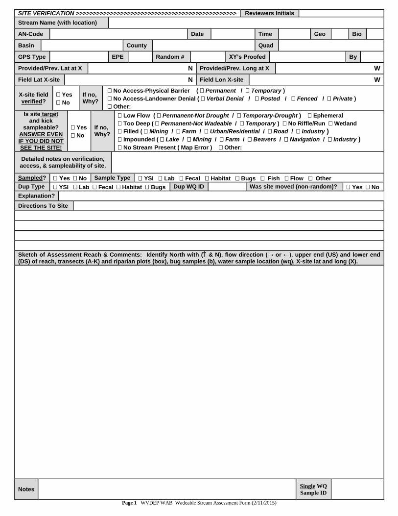
SITE VERIFICATION >>>>>>>>>>>>>>>>>>>>>>>>>>>>>>>>>>>>>>>>>>>>>>> Reviewers Initials
Stream Name (with location)
AN-Code Date Time Geo Bio
Basin County Quad
GPS Type EPE Random # XY’s Proofed By
Provided/Prev. Lat at X N Provided/Prev. Long at X W
Field Lat X-site N Field Lon X-site W
X-site field verified?
Yes
No
If no, Why?
No Access-Physical Barrier ( Permanent / Temporary )
No Access-Landowner Denial ( Verbal Denial / Posted / Fenced / Private )
Other: Is site target
and kick sampleable?
ANSWER EVEN IF YOU DID NOT SEE THE SITE!
Yes
No
If no, Why?
Low Flow ( Permanent-Not Drought / Temporary-Drought ) Ephemeral
Too Deep ( Permanent-Not Wadeable / Temporary ) No Riffle/Run Wetland
Filled ( Mining / Farm / Urban/Residential / Road / Industry )
Impounded ( Lake / Mining / Farm / Beavers / Navigation / Industry )
No Stream Present ( Map Error ) Other:
Detailed notes on verification, access, & sampleability of site.
Sampled? Yes No Sample Type YSI Lab Fecal Habitat Bugs Fish Flow Other
Dup Type YSI Lab Fecal Habitat Bugs Dup WQ ID Was site moved (non-random)? Yes No
Explanation?
Directions To Site
Sketch of Assessment Reach & Comments: Identify North with ( & N), flow direction (→ or ←), upper end (US) and lower end (DS) of reach, transects (A-K) and riparian plots (box), bug samples (b), water sample location (wq), X-site lat and long (X).
Notes Single WQ
Sample ID
Page 1 WVDEP WAB Wadeable Stream Assessment Form (2/11/2015)
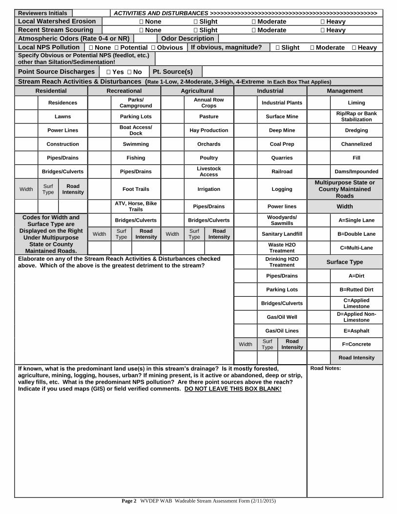
Reviewers Initials ACTIVITIES AND DISTURBANCES >>>>>>>>>>>>>>>>>>>>>>>>>>>>>>>>>>>>>>>>>>>>>>>>>
Local Watershed Erosion None Slight Moderate Heavy
Recent Stream Scouring None Slight Moderate Heavy
Atmospheric Odors (Rate 0-4 or NR) Odor Description
Local NPS Pollution None Potential Obvious If obvious, magnitude? Slight Moderate Heavy
Specify Obvious or Potential NPS (feedlot, etc.) other than Siltation/Sedimentation!
Point Source Discharges Yes No Pt. Source(s)
Stream Reach Activities & Disturbances (Rate 1-Low, 2-Moderate, 3-High, 4-Extreme In Each Box That Applies)
Residential Recreational Agricultural Industrial Management
Residences Parks/
Campground
Annual Row Crops
Industrial Plants Liming
Lawns Parking Lots Pasture Surface Mine Rip/Rap or Bank
Stabilization
Power Lines Boat Access/
Dock Hay Production Deep Mine Dredging
Construction Swimming Orchards Coal Prep Channelized
Pipes/Drains Fishing Poultry Quarries Fill
Bridges/Culverts Pipes/Drains Livestock Access
Railroad Dams/Impounded
Width Surf Type
Road
Intensity Foot Trails Irrigation Logging
Multipurpose State or County Maintained
Roads
ATV, Horse, Bike Trails
Pipes/Drains Power lines Width
Codes for Width and Surface Type are
Displayed on the Right Under Multipurpose
State or County Maintained Roads.
Bridges/Culverts Bridges/Culverts Woodyards/
Sawmills A=Single Lane
Width Surf Type
Road Intensity
Width Surf Type
Road Intensity
Sanitary Landfill B=Double Lane
Waste H2O Treatment
C=Multi-Lane
Elaborate on any of the Stream Reach Activities & Disturbances checked above. Which of the above is the greatest detriment to the stream?
Drinking H2O
Treatment Surface Type
Pipes/Drains A=Dirt
Parking Lots B=Rutted Dirt
Bridges/Culverts C=Applied Limestone
Gas/Oil Well D=Applied Non-
Limestone
Gas/Oil Lines E=Asphalt
Width Surf
Type
Road Intensity
F=Concrete
Road Intensity
If known, what is the predominant land use(s) in this stream’s drainage? Is it mostly forested, agriculture, mining, logging, houses, urban? If mining present, is it active or abandoned, deep or strip, valley fills, etc. What is the predominant NPS pollution? Are there point sources above the reach? Indicate if you used maps (GIS) or field verified comments. DO NOT LEAVE THIS BOX BLANK!
Road Notes:
Page 2 WVDEP WAB Wadeable Stream Assessment Form (2/11/2015)
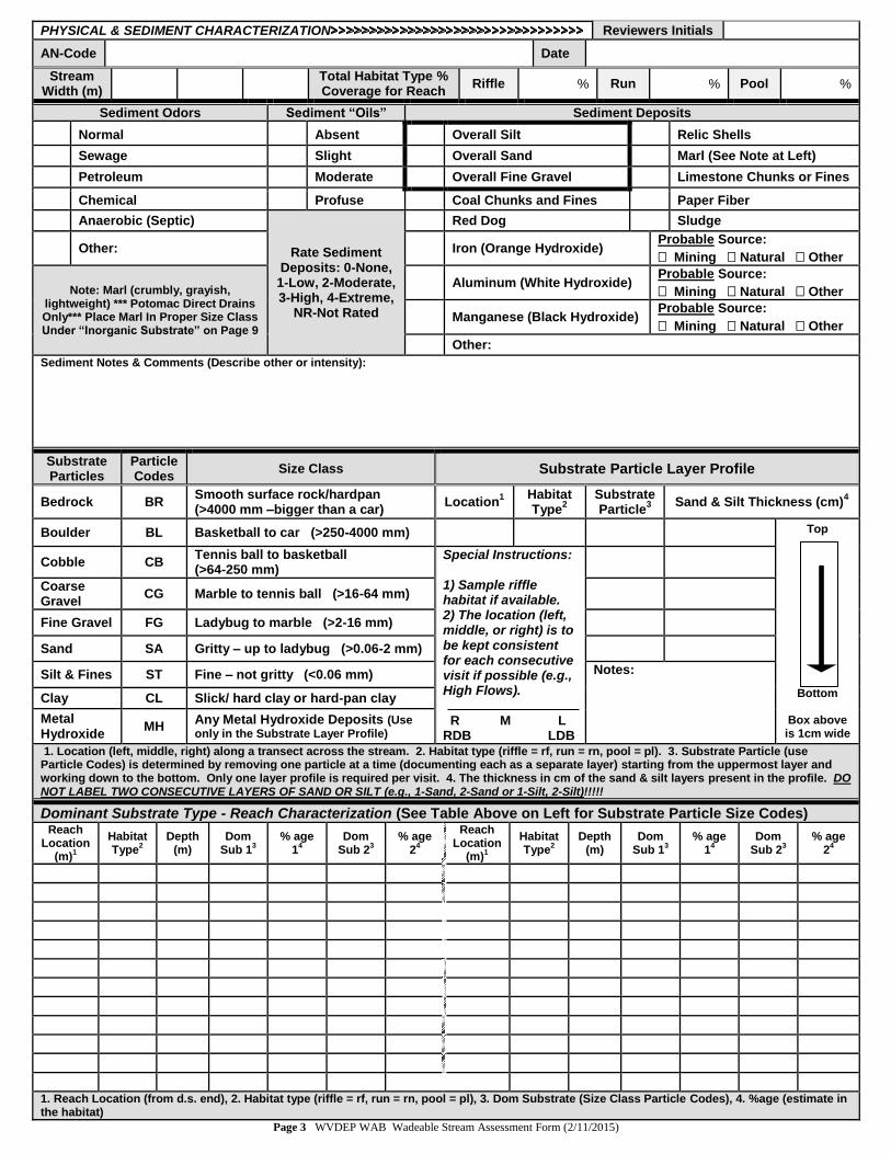
PHYSICAL & SEDIMENT CHARACTERIZATION Reviewers Initials
AN-Code Date
Stream Width (m)
Total Habitat Type % Coverage for Reach
Riffle % Run % Pool %
Sediment Odors Sediment “Oils” Sediment Deposits
Normal Absent Overall Silt Relic Shells
Sewage Slight Overall Sand Marl (See Note at Left)
Petroleum Moderate Overall Fine Gravel Limestone Chunks or Fines
Chemical Profuse Coal Chunks and Fines Paper Fiber
Anaerobic (Septic)
Rate Sediment Deposits: 0-None,
1-Low, 2-Moderate, 3-High, 4-Extreme,
NR-Not Rated
Red Dog Sludge
Other: Iron (Orange Hydroxide) Probable Source:
Mining Natural Other
Note: Marl (crumbly, grayish, lightweight) *** Potomac Direct Drains Only*** Place Marl In Proper Size Class Under “Inorganic Substrate” on Page 9
Aluminum (White Hydroxide) Probable Source:
Mining Natural Other
Manganese (Black Hydroxide) Probable Source:
Mining Natural Other
Other:
Sediment Notes & Comments (Describe other or intensity):
Substrate Particles
Particle Codes
Size Class Substrate Particle Layer Profile
Bedrock BR Smooth surface rock/hardpan (>4000 mm –bigger than a car)
Location1
Habitat Type
2
SubstrateParticle
3
Sand & Silt Thickness (cm)4
Boulder BL Basketball to car (>250-4000 mm) Top
Bottom
Box above is 1cm wide
Cobble CB Tennis ball to basketball (>64-250 mm)
Special Instructions: 1) Sample riffle habitat if available. 2) The location (left, middle, or right) is to be kept consistent for each consecutive visit if possible (e.g., High Flows). R M L RDB LDB
Coarse Gravel
CG Marble to tennis ball (>16-64 mm)
Fine Gravel FG Ladybug to marble (>2-16 mm)
Sand SA Gritty – up to ladybug (>0.06-2 mm)
Silt & Fines ST Fine – not gritty (<0.06 mm) Notes:
Clay CL Slick/ hard clay or hard-pan clay
Metal Hydroxide
MH Any Metal Hydroxide Deposits (Use only in the Substrate Layer Profile)
1. Location (left, middle, right) along a transect across the stream. 2. Habitat type (riffle = rf, run = rn, pool = pl). 3. Substrate Particle (use Particle Codes) is determined by removing one particle at a time (documenting each as a separate layer) starting from the uppermost layer and working down to the bottom. Only one layer profile is required per visit. 4. The thickness in cm of the sand & silt layers present in the profile. DO NOT LABEL TWO CONSECUTIVE LAYERS OF SAND OR SILT (e.g., 1-Sand, 2-Sand or 1-Silt, 2-Silt)!!!!!
Dominant Substrate Type - Reach Characterization (See Table Above on Left for Substrate Particle Size Codes) Reach
Location(m)
1
Habitat Type
2 Depth
(m) Dom
Sub 13
% age 1
4 Dom
Sub 23
% age 2
4
Reach Location
(m)1
Habitat Type
2 Depth
(m) Dom
Sub 13
% age 1
4 Dom
Sub 23
% age 2
4
1. Reach Location (from d.s. end), 2. Habitat type (riffle = rf, run = rn, pool = pl), 3. Dom Substrate (Size Class Particle Codes), 4. %age (estimate in the habitat)
Page 3 WVDEP WAB Wadeable Stream Assessment Form (2/11/2015)

Reviewers Initials FIELD WATER & RIPARIAN VEGETATION ZONE MEASURES>>>>>>>>>>>>>>>>>>>>>>>>>>>>>>
WQ Sample Location
Mid-Stream Bank ( Left Right) Thalweg ( Left Middle Right)
Left Channel Right Channel Cross Section Other:
WQ Type
Single Profile
Other:
Sonde Method Grab Sample Tube Bucket Lab Water Method Grab Sample Tube Bucket
Fla
g Physicochemical Parameters
(for a Single Water Quality Sample)
Seasonal Water Level
Water Odors Surface “Oils” Turbidity
Temperature C Below Normal Normal None Clear
pH (std. Units) Normal Sewage (Not Septic)
Flecks Slightly Turbid
Dissolved Oxygen (mg/L)
Above Normal Petroleum Sheen Moderately Turbid
Conductivity
(mhos/cm) Flooding Chemical Globs Highly Turbid
Sonde I.D. #:________
If any problems occur with the Water Meter or any readings are suspect, record notes in the space to the right.
Notes: Anaerobic (septic) Slick Water color:
Other:
Foam/Suds (Rate 0-4 or NR)
ABOVE: Record readings in box for corresponding physicochemical parameter. Insert a in the box for other categories.
Precipitation Status and History
Current Past 24
Hours (If Known)
Major Rain
Event in past week?
Yes
No
If it is raining or has rained recently, which of the following best describes the peak runoff (flush) condition of the stream at the site when water samples were collected? If the runoff condition is in response to snowmelt, please indicate as such above.
N/A < 1
Hour
1 to 4 Hours
4 to 12 Hours
12 to 24 Hours
1 to 2 Days
2 to 4 Days
4 to 7 Days
Unknown
Is the stream level rising, falling, or at baseflow at the time of visit? Unknown Baseflow Rising Falling
Stream Bank/Riparian Buffer Zone Vegetation/Cover Type
What is the dominant vegetation type in the reach? Deciduous Coniferous (i.e., Spruce, Pine, Hemlock, Rhododendron)
Mixed Deciduous (>10-49% Coniferous) Mixed Coniferous (>10-49% Deciduous)
Score Codes: 0=Absent (0%) 1=Sparse (0-<10%) 2=Moderate (10-40%) 3=Heavy (>40-75%) 4=Very Heavy (>75%)
Left & Right Bank While Facing Down-Stream
Determined Within The 1
st 18 m (60
Ft) From Stream Edge
Canopy (>5 M High) (>15 Feet)
Understory (0.5 – 5 M High) (1.5-15 Feet)
Ground Cover (<0.5 M High)
(1.5 Feet) Bare / Barren Soil
Big Trees such as Sycamore, Oaks, Maples,
Box Elder, River Birch, Hemlock
Small trees and shrubby Vegetation such as Willow,
Alder, Knotweed (blue devil), Rhododendron,
Wingstem
Ferns, Grasses, Mosses, Wildflowers
Exposed soil surface, Readily erodible – not rock
faces or asphalt roads
LEFT (18 m) (60 ft)
RIGHT (18 m) (60 ft)
Stream Surface Shading (%) Indicate % based on cloudless day in summer at noon. Place a in box that applies.
Fully Exposed (0-25%) Partly Shaded (25-50%) Partly Exposed (50-75%) Fully Shaded (75-100%)
General Comments (include land cover types outside of 18 m zone on left and right side that may impact water quality at the stream site). Provide your impression of the buffering capacity of the riparian zone in the 100 m reach including width, allochthonous input, topography, and plant composition.
Amphibian pool in riparian area? Vernal Mud Puddle Sed. Pond Farm Pond Ditch Lake Cattail Wetland Other Comments:
Invasive Species in the reach riparian
area?
Trees: Tree-of-Heaven Vines: Kudzu Japan. Honeysuckle
Bushes: Autumn Olive Multi-flora Rose Japan. Barberry
Herbaceous/Tall GC: Japan. Knotweed Bamboo Mile-A-Minute
Other:
Grass/Low GC: Japan. Stilt Grass Crown Vetch Purple Loosestrife Garlic Mustard
Page 4 WVDEP WAB Wadeable Stream Assessment Form (2/11/2015)
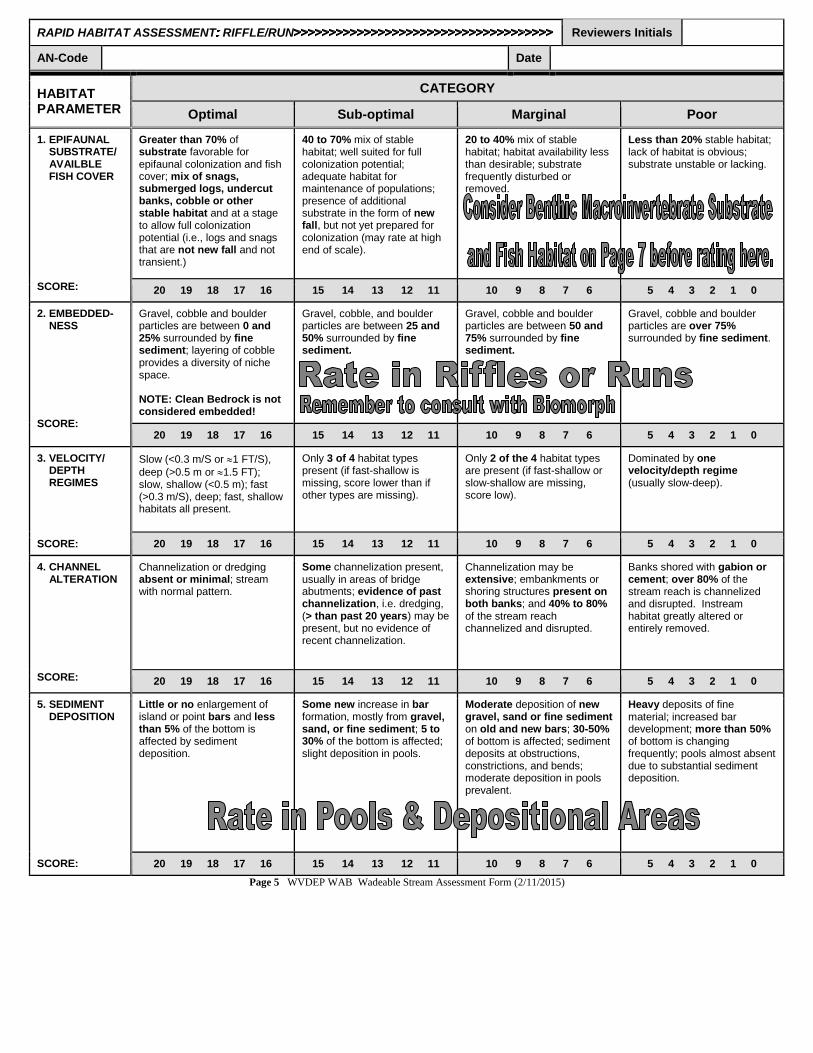
RAPID HABITAT ASSESSMENT RIFFLE/RUN Reviewers Initials
AN-Code Date
HABITAT PARAMETER
CATEGORY
Optimal Sub-optimal Marginal Poor
1. EPIFAUNAL SUBSTRATE/ AVAILBLE FISH COVER SCORE:
Greater than 70% of substrate favorable for epifaunal colonization and fish cover; mix of snags, submerged logs, undercut banks, cobble or other stable habitat and at a stage to allow full colonization potential (i.e., logs and snags that are not new fall and not transient.)
40 to 70% mix of stable habitat; well suited for full colonization potential; adequate habitat for maintenance of populations; presence of additional substrate in the form of new fall, but not yet prepared for colonization (may rate at high end of scale).
20 to 40% mix of stable habitat; habitat availability less than desirable; substrate frequently disturbed or removed.
Less than 20% stable habitat; lack of habitat is obvious; substrate unstable or lacking.
20 19 18 17 16 15 14 13 12 11 10 9 8 7 6 5 4 3 2 1 0
2. EMBEDDED- NESS SCORE:
Gravel, cobble and boulder particles are between 0 and 25% surrounded by fine sediment; layering of cobble provides a diversity of niche space. NOTE: Clean Bedrock is not considered embedded!
Gravel, cobble, and boulder particles are between 25 and 50% surrounded by fine sediment.
Gravel, cobble and boulder particles are between 50 and 75% surrounded by fine sediment.
Gravel, cobble and boulder particles are over 75% surrounded by fine sediment.
20 19 18 17 16 15 14 13 12 11 10 9 8 7 6 5 4 3 2 1 0
3. VELOCITY/ DEPTH REGIMES SCORE:
Slow (<0.3 m/S or 1 FT/S),
deep (>0.5 m or 1.5 FT); slow, shallow (<0.5 m); fast (>0.3 m/S), deep; fast, shallow habitats all present.
Only 3 of 4 habitat types present (if fast-shallow is missing, score lower than if other types are missing).
Only 2 of the 4 habitat types are present (if fast-shallow or slow-shallow are missing, score low).
Dominated by one velocity/depth regime (usually slow-deep).
20 19 18 17 16 15 14 13 12 11 10 9 8 7 6 5 4 3 2 1 0
4. CHANNEL ALTERATION SCORE:
Channelization or dredging absent or minimal; stream with normal pattern.
Some channelization present, usually in areas of bridge abutments; evidence of past channelization, i.e. dredging, (> than past 20 years) may be present, but no evidence of recent channelization.
Channelization may be extensive; embankments or shoring structures present on both banks; and 40% to 80% of the stream reach channelized and disrupted.
Banks shored with gabion or cement; over 80% of the stream reach is channelized and disrupted. Instream habitat greatly altered or entirely removed.
20 19 18 17 16 15 14 13 12 11 10 9 8 7 6 5 4 3 2 1 0
5. SEDIMENT DEPOSITION SCORE:
Little or no enlargement of island or point bars and less than 5% of the bottom is affected by sediment deposition.
Some new increase in bar formation, mostly from gravel, sand, or fine sediment; 5 to 30% of the bottom is affected; slight deposition in pools.
Moderate deposition of new gravel, sand or fine sediment on old and new bars; 30-50% of bottom is affected; sediment deposits at obstructions, constrictions, and bends; moderate deposition in pools prevalent.
Heavy deposits of fine material; increased bar development; more than 50% of bottom is changing frequently; pools almost absent due to substantial sediment deposition.
20 19 18 17 16 15 14 13 12 11 10 9 8 7 6 5 4 3 2 1 0
Page 5 WVDEP WAB Wadeable Stream Assessment Form (2/11/2015)

Reviewers Initials RAPID HABITAT ASSESSMENT RIFFLE/RUN >>>>>>>>>>>>>>>>>>>>>>>>>>>>>>>>>>>>>>>>>>>
HABITAT PARAMETER
CATEGORY
Optimal Sub-optimal Marginal Poor
6. RIFFLE FREQUENCY SCORE:
Occurrence of riffles is relatively frequent; ratio of distance between riffles divided by the width of the stream is <7:1 (generally 5 to 7); variety of habitat is key in streams where riffles are continuous; placement of boulders or other large natural obstruction is important. Rate lower in this category accordingly!
Occurrence of riffles is infrequent; distance between riffles divided by the width of the stream equals 7 to 15.
Occasional riffle or bend; bottom contours provide some habitat; distances between riffles divided by the width of the stream is between 15 to 25.
Generally all flat water or shallow riffles; poor habitat; distance between riffles divided by width of the stream is greater than 25.
20 19 18 17 16 15 14 13 12 11 10 9 8 7 6 5 4 3 2 1 0
7. CHANNEL FLOW STATUS SCORE:
Water reaches the base of both banks and a minimal area of channel substrate is exposed.
Water fills more than 75% of the available channel; or less than 25% of the channel substrate is exposed.
Water fills 25 to 75% of the available channel; and/or riffle substrates are mostly exposed.
Very little water in channel, and mostly present as standing pools.
20 19 18 17 16 15 14 13 12 11 10 9 8 7 6 5 4 3 2 1 0
8. BANK STABILITY TOTAL SCORE:
Banks stable; evidence of erosion or bank failure absent or minimal; little potential for future problems (<5% of bank affected).
Moderately stable; infrequent, small areas of erosion mostly healed over; 5-30% of bank in reach has areas of erosion.
Moderately unstable; 30-60% of bank in reach has areas of erosion; high potential during floods.
Unstable; many eroded areas; “raw” areas frequent along straight sections and bends; obvious bank sloughing; 60-100% of bank has erosional scars.
LEFT: 10 9 8 7 6 5 4 3 2 1 0
RIGHT: 10 9 8 7 6 5 4 3 2 1 0
9. BANK VEGETATIVE PROTECTION TOTAL SCORE:
More than 90% of the stream bank surfaces and immediate riparian zones (crest-over) covered by native vegetation including trees, understory shrubs, and non-woody plants (herbs, grasses, ferns, mosses); vegetative disruption through grazing or mowing minimal or not evident; almost all plants allowed to grow naturally.
70-90% of the stream bank surfaces are covered by native vegetation, but one class of plants is not well represented; disruption evident, but not affecting plant growth potential to any great extent; more than one-half of the potential plant stubble height remaining.
50-70% of the stream bank surfaces are covered by native vegetation; disruption obvious; patches of bare soil or closely cropped vegetation common; less than one-half of the potential plant stubble height remaining.
Less than 50% of the stream bank surfaces are covered by native vegetation; disruption of stream bank vegetation very high; vegetation has been removed to 2 inches or less in average stubble height.
LEFT: 10 9 8 7 6 5 4 3 2 1 0
RIGHT: 10 9 8 7 6 5 4 3 2 1 0
10. WIDTH OF UNDISTURBED VEG. ZONE TOTAL SCORE:
Width of undisturbed vegetative zone is >18 meters; human activities (parking lots, roadbeds, clear cuts, lawns, or crops) have not impacted this zone.
Zone width is between 12 and 18 meters; human activities have only minimally impacted this zone.
Zone width is between 6 and 12 meters; human activities have impacted the zone a great deal.
Width of zone is less than 6 meters; little or no un-disturbed vegetation due to man-induced activities.
LEFT: 10 9 8 7 6 5 4 3 2 1 0
RIGHT: 10 9 8 7 6 5 4 3 2 1 0
TOTAL: Optimal=160-200 Sub-Optimal=110-159 Marginal=60-109 Poor=0-59
Page 6 WVDEP WAB Wadeable Stream Assessment Form (2/11/2015)
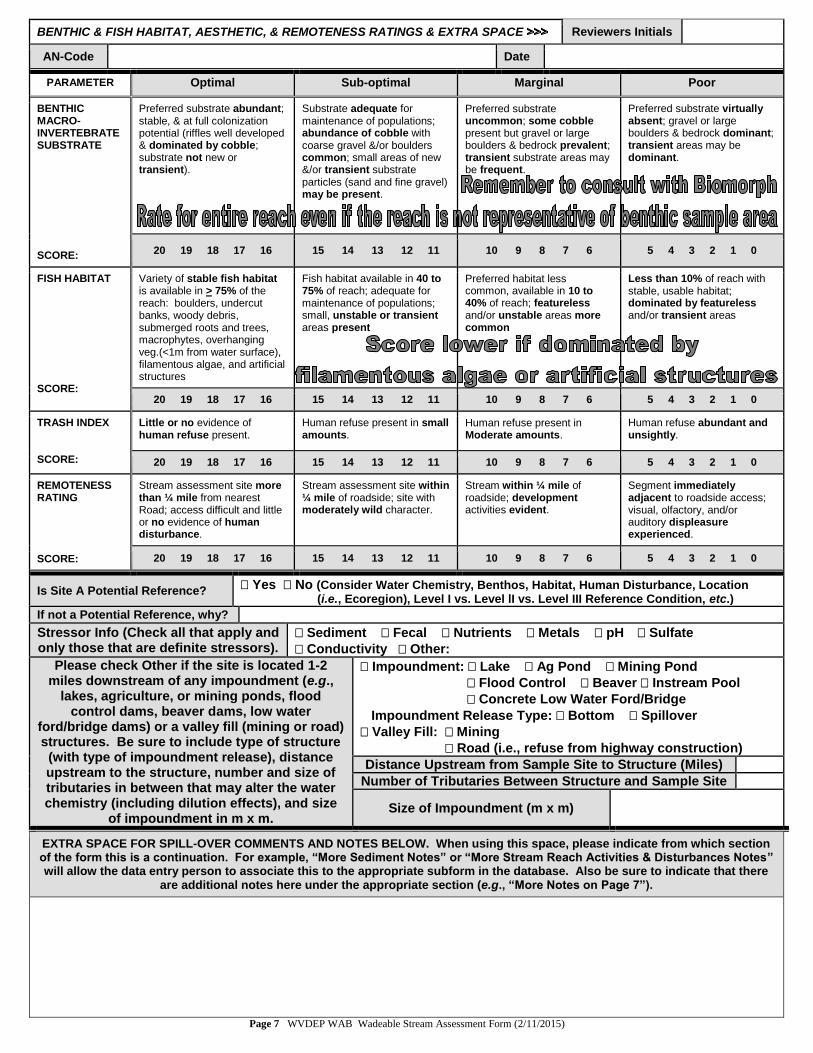
BENTHIC & FISH HABITAT, AESTHETIC, & REMOTENESS RATINGS & EXTRA SPACE Reviewers Initials
AN-Code Date
PARAMETER Optimal Sub-optimal Marginal Poor
BENTHIC MACRO-INVERTEBRATESUBSTRATE SCORE:
Preferred substrate abundant; stable, & at full colonization potential (riffles well developed & dominated by cobble; substrate not new or transient).
Substrate adequate for maintenance of populations; abundance of cobble with coarse gravel &/or boulders common; small areas of new &/or transient substrate particles (sand and fine gravel) may be present.
Preferred substrate uncommon; some cobble present but gravel or large boulders & bedrock prevalent; transient substrate areas may be frequent.
Preferred substrate virtually absent; gravel or large boulders & bedrock dominant; transient areas may be dominant.
20 19 18 17 16 15 14 13 12 11 10 9 8 7 6 5 4 3 2 1 0
FISH HABITAT SCORE:
Variety of stable fish habitat is available in > 75% of the reach: boulders, undercut banks, woody debris, submerged roots and trees, macrophytes, overhanging veg.(<1m from water surface), filamentous algae, and artificial structures
Fish habitat available in 40 to 75% of reach; adequate for maintenance of populations; small, unstable or transient areas present
Preferred habitat less common, available in 10 to 40% of reach; featureless and/or unstable areas more common
Less than 10% of reach with stable, usable habitat; dominated by featureless and/or transient areas
20 19 18 17 16 15 14 13 12 11 10 9 8 7 6 5 4 3 2 1 0
TRASH INDEX SCORE:
Little or no evidence of human refuse present.
Human refuse present in small amounts.
Human refuse present in Moderate amounts.
Human refuse abundant and unsightly.
20 19 18 17 16 15 14 13 12 11 10 9 8 7 6 5 4 3 2 1 0
REMOTENESS RATING SCORE:
Stream assessment site more than ¼ mile from nearest Road; access difficult and little or no evidence of human disturbance.
Stream assessment site within ¼ mile of roadside; site with moderately wild character.
Stream within ¼ mile of roadside; development activities evident.
Segment immediately adjacent to roadside access; visual, olfactory, and/or auditory displeasure experienced.
20 19 18 17 16 15 14 13 12 11 10 9 8 7 6 5 4 3 2 1 0
Is Site A Potential Reference? Yes No (Consider Water Chemistry, Benthos, Habitat, Human Disturbance, Location
(i.e., Ecoregion), Level I vs. Level lI vs. Level III Reference Condition, etc.)
If not a Potential Reference, why?
Stressor Info (Check all that apply and only those that are definite stressors).
Sediment Fecal Nutrients Metals pH Sulfate
Conductivity Other:
Please check Other if the site is located 1-2 miles downstream of any impoundment (e.g.,
lakes, agriculture, or mining ponds, flood control dams, beaver dams, low water
ford/bridge dams) or a valley fill (mining or road) structures. Be sure to include type of structure
(with type of impoundment release), distance upstream to the structure, number and size of tributaries in between that may alter the water chemistry (including dilution effects), and size
of impoundment in m x m.
Impoundment: Lake Ag Pond Mining Pond
Flood Control Beaver Instream Pool
Concrete Low Water Ford/Bridge
Impoundment Release Type: Bottom Spillover
Valley Fill: Mining
Road (i.e., refuse from highway construction)
Distance Upstream from Sample Site to Structure (Miles)
Number of Tributaries Between Structure and Sample Site
Size of Impoundment (m x m)
EXTRA SPACE FOR SPILL-OVER COMMENTS AND NOTES BELOW. When using this space, please indicate from which section of the form this is a continuation. For example, “More Sediment Notes” or “More Stream Reach Activities & Disturbances Notes” will allow the data entry person to associate this to the appropriate subform in the database. Also be sure to indicate that there
are additional notes here under the appropriate section (e.g., “More Notes on Page 7”).
Page 7 WVDEP WAB Wadeable Stream Assessment Form (2/11/2015)

Reviewers Initials WILDLIFE OBSERVATIONS >>>>>>>>>>>>>>>>>>>>>>>>>>>>>>>>>>>>>>>>>>>>>>>>>>>>>>>>>>
List organisms/wildlife that you observed at the sample site. Any organisms observed and put into the Benthic Sample Jar should be noted on page 9 under Benthic Sample Notes. PLEASE NOTE ANY NON-TROUT FISH OR
SALAMANDERS RELEASED FROM THE BENTHIC SAMPLE HERE! ALL TROUT SHOULD BE NOTED ONLY IN THE SECTION BELOW! INVASIVE PLANT SPECIES SHOULD BE NOTED ON PAGE 4 IN THE RIPARIAN VEGETATION
SECTION. REMEMBER TO DOCUMENT ANY SPECIMENS COLLECTED FOR OTHER GROUPS HERE!
Common Name Genus Species Comments Number
Observed Invasive? Observer
Did you see freshwater mussels? Yes No Alive Dead Did you collect dead shells? Yes No
Trout Observations (For Sites that are not actively being sampled for Fish!)
Did you see trout? Yes No Comments
Observation Method (i.e., Benthic Net, Free
Swimming, Rod & Reel)
Species ID (i.e., Brook Trout, Brown Trout, or Rainbow
Trout)
Count Size (cm)
Notes (e.g., YOY,
DELTs)
Photo #’s (Enter
Photo Details on Page 10)
Page 8 WVDEP WAB Wadeable Stream Assessment Form (2/11/2015)

BENTHIC MACROINVERTEBRATE & PERIPHYTON/ALGAE/AQ. PLANT INFO>>>>>>>>>>>> Reviewers Initials
AN-Code Date
Benthic sample collected?
Yes
No
If no, why?
Benthic collection device Kicknet D-net Hand Benthic habitat type & # Riffles Runs
Benthic sample comparability Was benthic sample comparable with respect to riffle/run depth and velocity? Yes No
Is there evidence that the stream channel was scoured by recent flooding or high flows? Yes No
Is it possible that sample areas were dry or partially dry for an extended period before sample was taken? Yes No
Is there evidence that the stream is “wet-weather” and flowing only in response to recent rainfall? Yes No
Benthic kick area depths m m m m
Use the space below to describe the site and explain responses to the previous questions. USE PAGES 10 & 11 TO DOCUMENT THE BENTHIC MACROINVERTEBRATES FOUND IN THE SAMPLE!!!
PLEASE NOTE ANY FISH, TROUT, OR SALAMANDERS RELEASED FROM THE BENTHIC SAMPLE ON PAGE 8!!!! Comment on the abundances and diversity of the organisms captured/observed and the overall benthic quality of the site.
Inorganic Substrate (1 m2
Of Kicked Substrate) Class Codes Size Class % Composition
Bedrock BR Smooth surface rock/hardpan (>4000 mm – bigger than a car) %
Boulder (BL) BL Basketball to car (>250-4000 mm) %
Cobble (CB) CB Tennis ball to basketball (>64-250 mm) %
Coarse Gravel (CG) CG Marble to tennis ball (>16-64 mm) %
Fine Gravel (FG) FG Ladybug to marble (>2-16 mm) %
Sand (SA) SA Gritty – up to ladybug (>0.06-2 mm) %
Silt & Fines (ST) ST Fine – not gritty (<0.06 mm) %
Clay (CL) CL Slick/ hard clay or hard-pan clay %
Enter estimated % composition for each substrate type. ****MACS SITES: estimate over entire 100 meter stream reach.****
Describe the benthic sampling substrate quality in terms of relative sizes (e.g., small-sized vs. large-sized cobble or boulders), shapes (globular vs. flat vs. angular), texture (e.g., rough vs. smooth bedrock), layering (i.e., was the cobble stacked) and embeddedness (embedded by pea gravel vs. sand/silt). Also mention any unusual substrate features (e.g., trash or unnatural substrate that was sampled as substrate) and provide general comments about the benthic sample substrate.
Indicate abundance of each: 0=None,
1=Low, 2=Moderate, 3=High, 4=Extreme,
NR=Not Rated
Periphyton (Brown-slick; Diatoms)
Filamentous
Algae (Green; Long)
Blue-Green Algae
(Blueish-Green Slime; Not Long)
Aquatic Mosses
Submerged Aquatic Plants (e.g.,
Stargrass, Hydrilla)
Emergent Aquatic Plants (e.g., Water
Willow)
Floating Aquatic Plants (e.g., Lily
Pads, Duckweed)
Total Aquatic Plants
Periphyton/Algae/Aquatic Plants & Mosses Notes:
Page 9 WVDEP WAB Wadeable Stream Assessment Form (2/11/2015)

Reviewers Initials MACROINVERTEBRATE OBSERVATIONS PART 1 >>>>>>>>>>>>>>>>>>>>>>>>>>>>>>>>>>>>>>>
Page 10 WVDEP WAB Wadeable Stream Assessment Form (2/11/2015)
Perlidae
Pteronarcyidae
Stoneflies
(Plecoptera)
Caddisflies
(Trichoptera)
Hydropsychidae
Peltoperlidae
Taeniopterygidae
Mayflies (Ephemeroptera)
Heptageniidae
Baetiscidae
Polycentropodidae
Brachycentridae
Limnephilidae
Hydroptilidae
Psephenidae
Elmidae (Adults)
Elmidae
Gyrindae
Beetles (Coleoptera)
Caenidae
Baetidae
Corydalidae
Sialidae
Fishflies, Hellgrammites,
Dobsonflies, Alderflies
(Megaloptera)
Odonata (Dragonflies & Damselflies)
Gomphidae
Misc. Case-Building Caddis
Other Beetles:
Dragonflies
Damselflies
Aeshnidae Illustrations by Tim Craddock
Isonychiidae Ephemeridae Other:
Perlodidae Chloroperlidae Other:
Rhyacophilidae Philopotamidae Other:
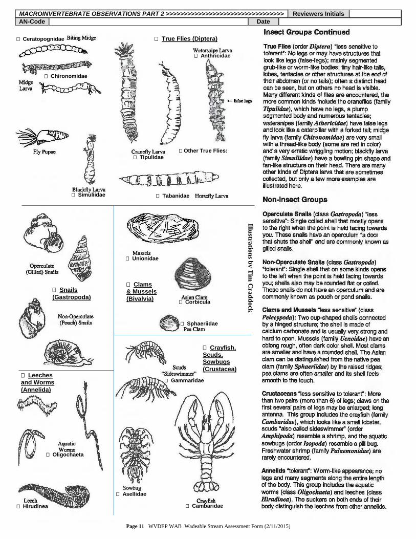
MACROINVERTEBRATE OBSERVATIONS PART 2 >>>>>>>>>>>>>>>>>>>>>>>>>>>>>>>>> Reviewers Initials
AN-Code Date
Page 11 WVDEP WAB Wadeable Stream Assessment Form (2/11/2015)
Illustra
tion
s by
Tim
Cra
dd
ock
Hirudinea
True Flies (Diptera)
Anthricidae
Tipulidae
Simuliidae
Chironomidae
Ceratopognidae
Snails
(Gastropoda)
Clams & Mussels
(Bivalvia)
Crayfish, Scuds, Sowbugs
(Crustacea)
Gammaridae
Cambaridae
Asellidae
Leeches and Worms
(Annelida)
Oligochaeta
Corbicula
Unionidae
Sphaeriidae
Tabanidae
Other True Flies:

Reviewers Initials LANDOWNER/STAKEHOLDER INFORMATION, RECON, & PHOTOS >>>>>>>>>>>>>>>>>>>>>>>
Landowner/ Stakeholder Name
Landowner/
Stakeholder Name
Address
Address
1oPhone # ( ) 1
oPhone # ( )
ALT # ( ) ALT # ( )
Stream Data Requested [ ] WS Report Requested [ ] Stream Data Requested [ ] WS Report Requested [ ] Other Pertinent Landowner Information (e.g., email) & Comments: Other Pertinent Landowner Information (e.g., email) & Comments:
Discuss the accessibility to the site including accessibility, posted property, fenced, beside road, long walk over treacherous terrain, hike length, 4 x 4 needed, get key from landowner, etc.
Check all that apply:
Easy Access Difficult Access Public Property Private Property Posted Fenced Gated
Get Key from Landowner Beside Road Short Hike Long Hike 4x4 Needed Other (explain)
Recon/Accessibility Notes:
Photography Log >>>>>>>>>>>>>>>> Camera Type Camera Number
# Photo ID (office)
Disk Photo # (field)
Stream Name and/or AN-Code
Photo Description (Use Key Words) Date Photographer
1
2
3
4
5
6
7
8
9
10
11
12
Page 12 WVDEP WAB Wadeable Stream Assessment Form (2/11/2015)