wyoming grasslands conservation plan · grassland ecosystem association, laurie van fleet, ......
TRANSCRIPT
A PLAN FOR BIRD AND MAMMAL SPECIES OF GREATEST
CONSERVATION NEED IN EASTERN WYOMING
GRASSLANDS
Wyoming Game and Fish Department
September 2006
ACKNOWLEDGEMENTS
The Wyoming Game and Fish Department acknowledges the efforts of the Grassland Plan Working Group. The group’s mission was to develop a plan for the conservation of terrestrial native wildlife species in the grasslands of eastern Wyoming. Sam Crowe U.S. Department of Agriculture, Wildlife Services Frank Eathorne Private landowner Mark Eisele Wyoming Stockgrowers Association Bill Gerhart Wyoming Game and Fish Department Martin Grenier Wyoming Game and Fish Department Ken Hamilton Wyoming Farm Bureau Paul Kruse County Commissions and Wheatland Irrigation District Kevin Lind Powder River Basin Resource Council Cristi Lockman U.S. Forest Service Allen Mooney Wyoming Weed and Pest Bob Oakleaf Wyoming Game and Fish Department Paul Obert Natural Resources Conservation Service Earl Reed Wyoming Wool Growers Jewell Reed Thunder Basin Grasslands Prairie Ecosystem Association Archie Reeve PIC Technologies Roy Reichenbach Wyoming Department of Agriculture Dave Roberts Bureau of Land Management Reg Rothwell Wyoming Game and Fish Department Rob Stephens Wyoming Game and Fish Department Renee Taylor Petroleum Association of Wyoming
Many other individuals contributed to this plan by providing constructive comments and information relative to their areas of expertise. Rob Stephens and Bryce Krueger prepared and polished some of the most recent drafts of the plan. Other helpful individuals include Ryan Amundson, Christina Barrineau, Larry Bourret, Gary Butler, Tim Byer, Andrea Cerovski, Don Christianson, Ken Driese, John Emmerich, Doug Faulkner, Willie Fitzgerald, Bert Jellison, Dennis Knight, Sarah Lantz, Jay Lesser, Richard Moore, Dave Neary, Regan Plumb, Dick Rintamaki, Keith Schoup, Steve Slater, Rick Straw, Ted Toombs, the Thunder Basin Prairie Grassland Ecosystem Association, Laurie Van Fleet, Nyssa Whitford and Steve Wolff. State Wildlife Grants funding was used to assist in preparing the plan.
September 2006 ii Wyoming Game and Fish Department
TABLE OF CONTENTS
Executive Summary 1 Introduction 2 Plan Goal and Objectives 4 Description of Wyoming Grasslands 5 Proposed Conservation Actions 12 Recommended Support Actions 14 Species of Greatest Conservation Need – Species Accounts 19 1. Black-footed Ferret 20 2. Black-tailed Prairie Dog 23 3. White-tailed Prairie Dog 27 4. Swift Fox 30 5. Other Grassland Mammals 33 6. Mountain Plover 34 7. Burrowing Owl 37 8. Ferruginous Hawk 40 9. Long-billed Curlew 42 10. Upland Sandpiper 45 11. Other Grassland Birds 47 Literature Cited 53 List of Tables 1. Mammals endemic to the grasslands of the Great Plains that are also present
in Wyoming. 7 2. Birds endemic to the grasslands of the Great Plains. 7 3. Land cover/use of nonfederal land in Wyoming by acreage. 11 4. Some potential funding sources for grassland conservation activities. 16 5. Average costs of some management practices employed by the Wyoming
Game and Fish Department’s Landowner Incentive Program that conserve or improve wildlife habitat. 17
6. Natural Resources Conservation Service/Farm Service Agency 2002 Farm Bill conservation programs. 18
7. Grassland species of greatest conservation need in Wyoming. 19 8. Preliminary survey results of black-tailed prairie dog complexes in Wyoming,
2003. 26 9. An index of swift fox population trend in Shirley Basin. 32 10. Range-wide Breeding Bird Survey trend estimates for grassland bird species
of special concern. 49 11. Select Rocky Mountain Bird Observatory grassland transect data from the
2004 field season. 52
September 2006 iii Wyoming Game and Fish Department
List of Figures 1. Distribution of mixed-grass and shortgrass prairies in Wyoming (modified
from Comer et al. [2003]). 6 2. Distribution of herbaceous/cultivated systems in Wyoming (modified from
Comer et al. [2003]). 10 3. Black-footed ferret distribution in Wyoming. 20 4. Black-tailed prairie dog distribution in Wyoming. 24 5. White-tailed prairie dog distribution in Wyoming. 28 6. Swift fox distribution in Wyoming. 31 7. Mountain Plover breeding distribution in Wyoming. 35 8. Burrowing Owl breeding distribution in Wyoming. 38 9. Ferruginous Hawk nesting distribution in Wyoming. 41 10. Long-billed curlew breeding distribution in Wyoming. 42 11. Upland Sandpiper breeding distribution in Wyoming. 46 12. Wyoming Breeding Bird Survey routes. 50 13. Rocky Mountain Bird Observatory grassland transect locations (n = 30) in
Wyoming from the 2004 field season. 51 List of Appendices Appendix A. Existing management plans and conservation strategies for
grassland wildlife. 60 Appendix B. Wyoming Game and Fish Department’s Native Species Status
Matrix. 62 Appendix C. Latilong blocks and species distributions in Wyoming. 63
September 2006 iv Wyoming Game and Fish Department
EXECUTIVE SUMMARY The grasslands of the Great Plains are one of the most imperiled ecosystems in North America. Conversion of grasslands, urbanization, fragmentation, invasion by noxious and invasive plants, and the removal of natural forms of disturbance all affect the viability of this ecosystem. As the overall condition of grassland habitat has steadily declined during the past two centuries, the distributions of many grassland-obligate species have also diminished. Examples include the black-footed ferret (Mustela nigripes), Burrowing Owl (Athene cunicularia hypugaea), swift fox (Vulpes velox), black-tailed prairie dog (Cynomys ludovicianus), Upland Sandpiper (Bartramia longicauda), and Mountain Plover (Charadrius montanus). As these trends become more apparent, natural resource stakeholders begin to question the long-term viability of some grassland species. Thus, the black-footed ferret was listed under the Endangered Species Act (ESA), and several other species have been petitioned for listing. It is realistic to expect that more species will be petitioned for listing under the ESA as impacts on grasslands continue to mount. Compared to many of the highly impacted regions of the Great Plains, grasslands in Wyoming are relatively healthy throughout much of their historical range. Of the grassland-obligate species declining in other parts of the Great Plains, the populations of most of these species within Wyoming appear to be secure. However, some of Wyoming’s grasslands have already been altered or converted for other uses. With time, impacts on grasslands will continue to mount. Wyoming is fortunate to have the opportunity to conserve its grasslands while they still exist across relatively large, intact landscapes. It is much more effective and less costly to conserve these areas now than to attempt to recreate them in the future. The overarching goal of this plan is to formalize the strategies that will help the Wyoming Game and Fish Department (WGFD) work cooperatively with landowners, other agencies, and the public to conserve healthy grassland ecosystems in Wyoming while maintaining economic sustainability. This plan will enable the WGFD to address the conservation needs of Wyoming’s grasslands and associated wildlife in a proactive manner.
September 2006 1 Wyoming Game and Fish Department
INTRODUCTION Because the overall condition of grassland habitat has steadily declined during the past two centuries, the grasslands of the Great Plains are considered one of the most imperiled ecosystems in North America (Samson and Knopf 1996, Samson et al. 1998). As a result, the distributions of many grassland-obligate species such as the black-footed ferret, Burrowing Owl, swift fox, black-tailed prairie dog, Upland Sandpiper, and Mountain Plover have also diminished (Samson et al. 1998). Fortunately, healthy grassland ecosystems are still present throughout much of their historical range within Wyoming. As a result, the swift fox, Burrowing Owl, black-tailed prairie dog, Mountain Plover and Upland Sandpiper are doing well in Wyoming. For example, the swift fox has experienced substantial declines in distribution and abundance from Nebraska to Canada. Monitoring efforts indicate that swift fox populations in Wyoming will remain viable into the foreseeable future, and Wyoming swift fox populations have been used as a source for fox translocations to other areas in the Great Plains. To date, conservation of Wyoming’s grasslands has resulted largely from the state’s low human population density, compatible management practices of many landowners, and the fact that Wyoming grasslands are not as suitable for conversion to croplands as other parts of the Great Plains. Population density in Wyoming was only 5.1 people/mi2, compared to 79.6 people/mi2 for the rest of the United States, in 2000 (U.S. Census Bureau 2006). This will not always be the case. Wyoming is projected to be the 11th fastest growing state by percentage of population, with an increase of 44% (214,000 people) between 1995 and 2025 (Campbell 1997). Signs of increasing pressure on Wyoming’s grasslands are apparent in areas such as Campbell and Laramie counties. In Campbell County, the population increased 160% between 1970 and 2000 (Wyoming Department of Administration and Information 2001). More recently, the population has increased with coalbed natural gas (CBNG) development, which is rapidly altering the area’s grasslands through road and well development and associated disturbances. This development provides yet another land use activity that can contribute to the establishment of noxious and invasive plants. Urban sprawl radiating outward from Cheyenne is contributing to habitat loss and fragmentation of grasslands in Laramie County. Supporters of economic growth associated with development assert that because Wyoming has an extremely low population, there is considerable time before we must face the problems challenging resource managers in other states with high human population densities, even if rapid growth rates are sustained. Therefore, there is no better time to recognize potential problems and take advantage of opportunities to avoid them than when they are conceptual as opposed to real. Wyoming is fortunate to have the opportunity to conserve its grasslands while they still exist across relatively large, intact landscapes. A key to conserving the grassland ecosystems in Wyoming is to develop a shared vision between all groups that have an interest. Particularly, it is vital to engage landowners to actively participate in grassland conservation. The goals and expectations of landowners need to be integrated with efforts to maintain habitat for wildlife. It is not uncommon for landowners to view plans such as this with apprehension: they are concerned that their livelihoods or lifestyles could be negatively impacted. However, landowner participation with WGFD in wildlife management actions on private lands is entirely voluntary. In order for the WGFD to successfully implement large-scale grassland conservation efforts, it
September 2006 2 Wyoming Game and Fish Department
will need to identify areas where private landowners and the WGFD have similar interests, and build upon those opportunities. Additionally, the WGFD recognizes humans as essential components of the landscape, and the importance of maintaining responsible economic use of resources must be factored into our primary mission of conserving the state’s wildlife. An important goal that the WGFD shares with private landowners is the avoidance of additional ESA species listings. Prior to this plan, several other plans containing conservation strategies for grassland wildlife relevant to this planning effort had been completed by the WGFD and other agencies and organizations (Appendix A). In addition, the WGFD’s Comprehensive Wildlife Conservation Strategy (CWCS) was completed in the summer of 2005 (WGFD 2005). Development and approval of the CWCS was a requirement for the WGFD to remain eligible for the federally appropriated funding known as State Wildlife Grants. Results from these planning efforts are included in the larger CWCS plan, which also contains information about the grassland ecosystem and species accounts for Wyoming’s species of greatest conservation need (SGCN). Both the CWCS and this plan use a fine filter to address issues affecting specific species of special concern and a coarse filter to address broader or ecosystem-level issues. In addition, documents produced by Partners in Flight (Wyoming Partners in Flight 2002) and the High Plains Partnership (Luce 2003b) provide best management practices (BMPs) for the conservation of many species present in Wyoming’s grasslands. However, because the documents are intended for broad geographic areas, some of the BMPs described are not necessarily applicable in Wyoming.
September 2006 3 Wyoming Game and Fish Department

PLAN GOAL AND OBJECTIVES The overarching goal of this plan is to identify strategies that will help the WGFD work cooperatively with landowners, other agencies, and the public to conserve healthy grassland ecosystems in Wyoming while maintaining economic sustainability. While there are numerous reasons to conserve grassland ecosystems, one important benefit is ensuring that wildlife populations remain viable, eliminating the need for future listings under the ESA. We anticipate that this plan will enable the WGFD to address prairie wildlife issues in a proactive manner rather than waiting for species to be petitioned for listing before enacting management efforts. The five primary objectives of this document are:
1) Enhance and conserve grassland habitat quality, and where opportunities exist,
increase grassland habitat quantity, thereby improving the long-term viability of terrestrial wildlife species endemic to grasslands.
2) Maintain effective inventory and monitoring programs for both habitat and wildlife
populations so data are available to: (a) prevent unwarranted listings under the ESA; and (b) identify issues and/or species that need special management attention.
3) Implement this plan’s proposed conservation actions, recommended support actions,
and species-specific actions and monitoring strategies to: (a) increase the population numbers of at-risk grassland species; (b) collect the data necessary to assess their conservation status; and (c) work towards removing these species from the list of SGCN in accordance with the goals and strategy of the CWCS (WGFD 2005).
4) Develop an understanding of the needs and values of private landowners and resource
managers to identify areas where WGFD conservation interests complement or enhance landowner needs. In these areas, form partnerships with landowners to promote conservation and facilitate inventory and monitoring programs. It is equally important to identify areas where interests could conflict and explore opportunities to mitigate impacts on private landowners.
5) Develop an information source (listing technical efforts and funding options) for
landowners that want to improve or restore grassland habitat.
September 2006 4 Wyoming Game and Fish Department
DESCRIPTION OF WYOMING GRASSLANDS This plan focuses primarily on the mixed-grass prairie and shortgrass prairie in eastern Wyoming. As described by Knight (1994), shortgrass prairie occurs mainly in the southeast corner of the state and extends south into Colorado. The dominance of buffalograss (Buchloe dactyloides) and blue grama (Bouteloua gracilis) is indicative of this grassland type. Mixed-grass prairie is common across much of eastern Wyoming. Mixed-grass prairies typically receive more moisture and have greater plant species diversity. Common plant species include needle-and-thread (Stipa comata), western wheat-grass (Agropyron smithii), blue grama, sandberg blue grass (Poa sandbergii), prairie junegrass (Koeleria macrantha), and Indian ricegrass (Oryzopsis hymenoides). Recently, Comer et al. (2003) presented a working classification and map of ecological systems in the United States. The effort is being widely accepted for updating the U.S. Geological Survey’s Gap Analysis Program (GAP) in adjacent states and will likely be used to update the Wyoming GAP analysis (Merrill et al. 1996). The Northwestern Great Plains Mixed-grass Prairie and the Western Great Plains Shortgrass Prairie (Figure 1) represent what Knight (1994) and this plan refer to as mixed-grass prairie and shortgrass prairie, respectively. In this plan, the term grassland is used when discussing issues common to both mixed-grass and short grass prairies. Comer et al. (2003) also described several other grassland types that occur in Wyoming, but they are not included in the focus of this plan. It is important to note that while the classification described by Comer et al. (2003) is valuable for providing an overall concept of terrestrial systems in Wyoming, it has yet to be verified with field evaluations and some site-specific errors should be expected. While the grasslands of Wyoming might appear at first glance to be relatively simple ecosystems, they support a great diversity of wildlife. Fifteen of the sixteen mammals considered narrow endemics to the grasslands of the Great Plains are found in Wyoming (Samson and Knopf 1996, Table 1). All nine species of birds considered narrow endemics of the Great Plains occur within Wyoming’s grasslands (Samson and Knopf 1996, Table 2). Of all the animals endemic to the grasslands, the black-tailed prairie dog is especially important because of its role as a keystone species (Kotliar et al. 1999, Kotliar 2000). By creating burrows and cropping the vegetation within a colony, prairie dogs create habitat for many other species including the Burrowing Owl, black-footed ferret, long-tailed weasel (Mustela frenata), Mountain Plover, and swift fox. The black-tailed prairie dog is also an important prey species of the black-footed ferret, Ferruginous Hawk (Buteo regalis), and Golden Eagle (Aquila chrysaetos). In contrast, other grassland species, such as the Upland Sandpiper, require habitat characteristics with greater residual cover, moderate to high litter cover, and little bare ground (Houston and Bowen 2001). Such differences in habitat requirements emphasize the need to manage for diversity and to recognize the ecological potential of different sites or situations. Historical Perspective and Current Land Use Trends Grasslands are home to a diverse array of species, resources, and interests. Native Americans historically occupied the grasslands and survived by hunting wildlife such as bison (Bison bison), pronghorn (Antilocapra americana), and elk (Cervus elaphus). Pioneers traveling west in the
September 2006 5 Wyoming Game and Fish Department
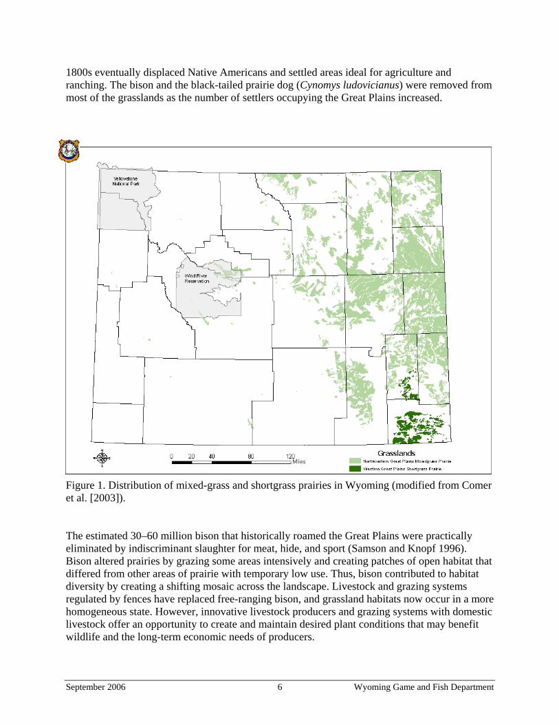
1800s eventually displaced Native Americans and settled areas ideal for agriculture and ranching. The bison and the black-tailed prairie dog (Cynomys ludovicianus) were removed from most of the grasslands as the number of settlers occupying the Great Plains increased.
Figure 1. Distribution of mixed-grass and shortgrass prairies in Wyoming (modified from Comer et al. [2003]).
The estimated 30–60 million bison that historically roamed the Great Plains were practically eliminated by indiscriminant slaughter for meat, hide, and sport (Samson and Knopf 1996). Bison altered prairies by grazing some areas intensively and creating patches of open habitat that differed from other areas of prairie with temporary low use. Thus, bison contributed to habitat diversity by creating a shifting mosaic across the landscape. Livestock and grazing systems regulated by fences have replaced free-ranging bison, and grassland habitats now occur in a more homogeneous state. However, innovative livestock producers and grazing systems with domestic livestock offer an opportunity to create and maintain desired plant conditions that may benefit wildlife and the long-term economic needs of producers.
September 2006 6 Wyoming Game and Fish Department
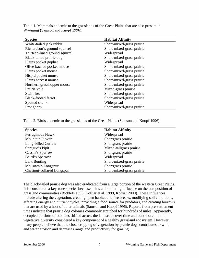
Table 1. Mammals endemic to the grasslands of the Great Plains that are also present in Wyoming (Samson and Knopf 1996). Species Habitat Affinity White-tailed jack rabbit Short-mixed-grass prairie Richardson’s ground squirrel Short-mixed-grass prairie Thirteen-lined ground squirrel Widespread Black-tailed prairie dog Short-mixed-grass prairie Plains pocket gopher Widespread Olive-backed pocket mouse Short-mixed-grass prairie Plains pocket mouse Short-mixed-grass prairie Hispid pocket mouse Short-mixed-grass prairie Plains harvest mouse Short-mixed-grass prairie Northern grasshopper mouse Short-mixed-grass prairie Prairie vole Mixed-grass prairie Swift fox Short-mixed-grass prairie Black-footed ferret Short-mixed-grass prairie Spotted skunk Widespread Pronghorn Short-mixed-grass prairie
Table 2. Birds endemic to the grasslands of the Great Plains (Samson and Knopf 1996). Species Habitat Affinity Ferruginous Hawk Widespread Mountain Plover Shortgrass prairie Long-billed Curlew Shortgrass prairie Sprague’s Pipit Mixed-tallgrass prairie Cassin’s Sparrow Shortgrass prairie Baird’s Sparrow Widespread Lark Bunting Short-mixed-grass prairie McCown’s Longspur Shortgrass prairie Chestnut-collared Longspur Short-mixed-grass prairie
The black-tailed prairie dog was also eradicated from a large portion of the western Great Plains. It is considered a keystone species because it has a dominating influence on the composition of grassland communities (Ricklefs 1993, Kotliar et al. 1999, Kotliar 2000). These influences include altering the vegetation, creating open habitat and fire breaks, modifying soil conditions, affecting energy and nutrient cycles, providing a food source for predators, and creating burrows that are used by a host of other animals (Samson and Knopf 1996). Reports from pre-settlement times indicate that prairie dog colonies commonly stretched for hundreds of miles. Apparently, occupied portions of colonies shifted across the landscape over time and contributed to the vegetative diversity considered a key component of a healthy grassland ecosystem. However, many people believe that the close cropping of vegetation by prairie dogs contributes to wind and water erosion and decreases rangeland productivity for grazing.
September 2006 7 Wyoming Game and Fish Department
Another influence of human occupation on grassland habitat characteristics relates to the control of wildfires. Fires on the Great Plains occurred at intervals of approximately 2–25 years (Wright and Bailey 1980). Wyoming grasslands are arid and probably burned less frequently than the more mesic grasslands of the Great Plains because they do not quickly accumulate the fine fuels necessary to carry fire (Knight 1994). Additionally, reduced fuel loads caused by intensive bison grazing and wallowing (Knapp et al. 1999) and prairie dog colonies (Kotliar et al. 1999) further altered fire intensity, frequency and burn patterns. Fire interacts with the landscape by affecting nutrient recycling and plant productivity. Burning, especially in taller grasslands, removes the insulating detritus, thereby allowing the soil to warm up sooner and plants to grow earlier in the spring, when water is available. Alternatively, water stress can be aggravated by fire if moisture that would have been used for plant growth during the short growing season evaporates from the warmer, blackened soil surface (Knight 1994). Thus, net primary productivity could increase or decrease depending on the circumstances. Grassland ecosystems are well adapted to this disturbance and like grazing, fire created a mosaic of habitat diversity across the landscape. However, fire regimes have been altered due to the adoption of fire suppression as a guiding principle for land management during the past century. Complete fire suppression can result in accumulation of mulch and conditions that favor cool-season exotic species, and it most likely accounts for the active invasion of woody plants in the southern portion of the northern mixed prairie (Samson and Knopf 1996). More recently, resource extraction has influenced the grassland ecosystem. Wyoming produces 35% of the nation’s coal supply (Wyoming Mining Association 2004), 96% of which originates in northeastern Wyoming grasslands (Campbell, Converse and Sheridan Counties) (Lyman and Jones 2005). CBNG development is also occurring in large portions of Wyoming’s grasslands, with most of the current activity localized in northeast Wyoming. An estimated 12,000 wells were developed within the Powder River Basin by 2003 (BLM 2003). The Bureau of Land Management (BLM) forecasts that another 39,000 CBNG wells may be developed in the Powder River Basin Environmental Impact Statement area over the next 10 years (BLM 2003). In an 8 x 11 mile area of heavy CBNG development in the Sheridan Region, road density is approximately 5 mi/mi2 (Bert Jellison, Habitat Biologist, WGFD, pers. comm.). Ingelfinger (2001) linked roads to decreased habitat effectiveness for wildlife and reported a 50% reduction in sagebrush-obligate passerines within 100 m of roads. If these effects are accurate for the above-mentioned Sheridan site, then 46% of the area has been impacted and has decreased habitat effectiveness. Plant and animal communities that occupied the Great Plains for thousands of years have been completely restructured in the last two centuries (Samson and Knopf 1996). Noxious and invasive plants may be the biggest threat and most significant conservation issue for grassland ecosystems. Some land use activities promote encroachment of noxious and invasive plants. The Wyoming Department of Agriculture monitors the distribution of noxious and invasive plants in Wyoming. Weeds that have altered the composition of native grassland flora in Wyoming include Canada thistle (Cirsium arvense), leafy spurge (Euphorbia esula), Russian knapweed (Acroptilon repens), spotted knapweed (Centaurea maculosa), saltcedar (Tamarix gallica), and cheatgrass (Bromus tectorum). Canada thistle, which is typically found in riparian areas, is the most widespread weed in the grasslands. Leafy spurge is a priority weed because it spreads easily and is difficult to eliminate. Leafy spurge is present on 60,000–70,000 acres statewide, mostly in Weston, Johnson, Crook, Sheridan, and Campbell counties. Russian knapweed is
September 2006 8 Wyoming Game and Fish Department
present in limited amounts (approximately 5,000 acres) in eastern Wyoming. Spotted knapweed is present on approximately 13,000 acres statewide, but is located mostly in western Wyoming. In eastern Wyoming, it is primarily found along roadways such as Interstate 90 and Highway 59. Saltcedar and cheatgrass are also present in eastern Wyoming, but estimates of abundance are not available (Roy Reichenbach, Weed and Pest Coordinator, Wyoming Department of Agriculture, personal communication). One of the greatest causes of grassland habitat loss in adjacent states during the past century was conversion for agriculture. While we were unable to obtain an estimate of Wyoming grasslands converted for agriculture, we do know that approximately 7% of Wyoming’s entire land area has been converted for this purpose (Comer et al. 2003, Figure 2). Dryland agriculture accounts for just under half of all agricultural activities, while irrigated farming constitutes the rest. However, data from the Natural Resources Conservation Service’s (NRCS) National Resources Inventory (NRI) indicates that land conversion for agricultural purposes does not currently pose a threat to grassland ecosystems in Wyoming (Table 3) (U.S. Department of Agriculture 2000). Partially due to conservation actions implemented through the Farm Bill, the amount of cropland in Wyoming has decreased by 413,700 acres between 1982 and 1997 (U.S. Department of Agriculture 2000). In addition, many grassland wildlife species also use agricultural fields during various phases of their life cycle. In fact, subirrigated native hay fields provide some of the state’s best nesting habitat for many wetland birds such as the Wilson’s Phalarope (Phalaropus lobatus), or grassland birds such as the Long-billed Curlew (Numenius americanus). This is especially true of fields that have not been leveled and are not under intensive management with machinery and chemical treatment. Priority areas Mixed-grass prairies in the Laramie Basin, Shirley Basin, Thunder Basin National Grasslands, and the Sheridan Region, short-grass prairie in southeastern Wyoming, and several areas where there are extensive prairie dog complexes have been selected as priority areas for conservation efforts. These areas have been selected based on biological importance, threats, and the potential for conservation success. A Geographic Information System (GIS) database will be developed to aid in prioritizing areas as GIS layers become available. Layers included in the GIS database will include current land cover classification, soils and baseline vegetation, wildlife populations, important wildlife habitats including seasonal ranges, property ownership, agriculture, oil and gas development, coal mines, urbanization, roads, distribution of noxious and invasive plants, significant land features, and aquatic and wetland resources.
September 2006 9 Wyoming Game and Fish Department
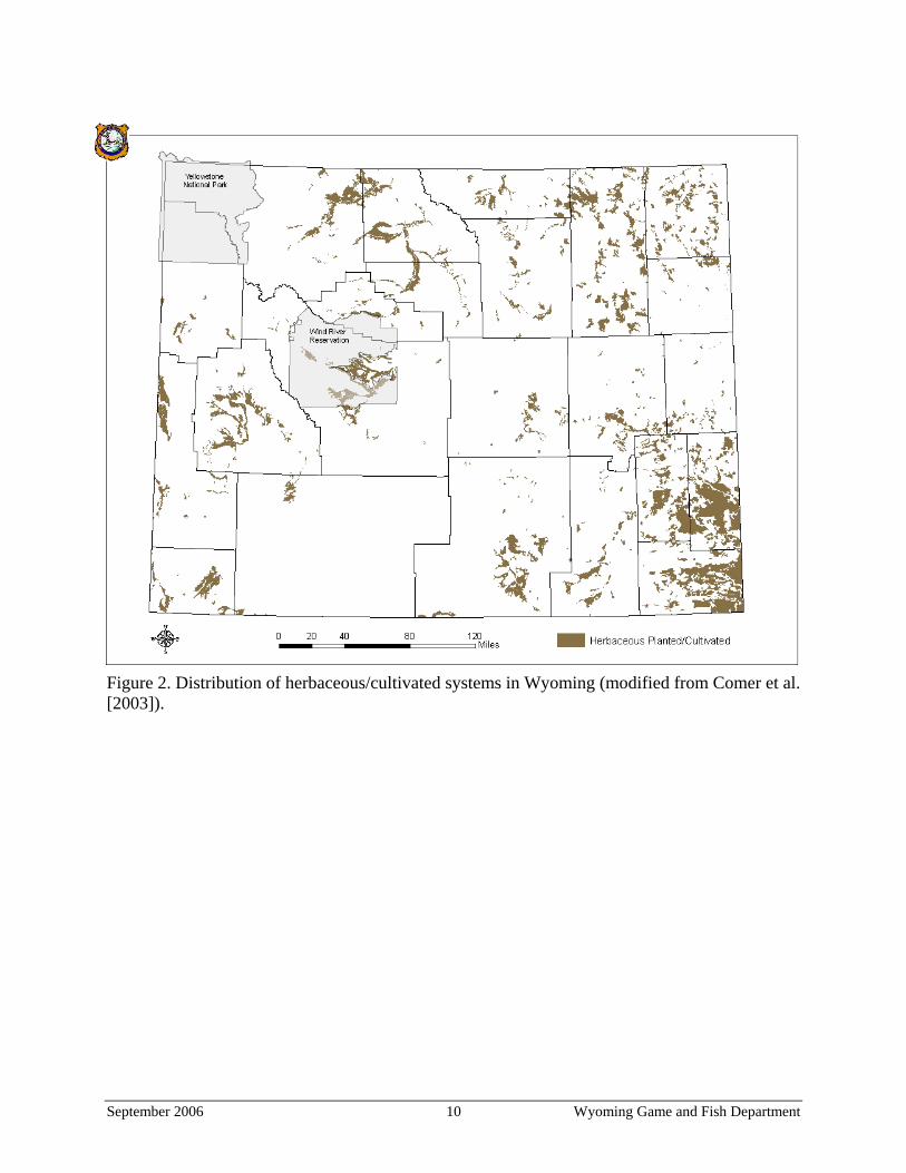
Figure 2. Distribution of herbaceous/cultivated systems in Wyoming (modified from Comer et al. [2003]).
September 2006 10 Wyoming Game and Fish Department
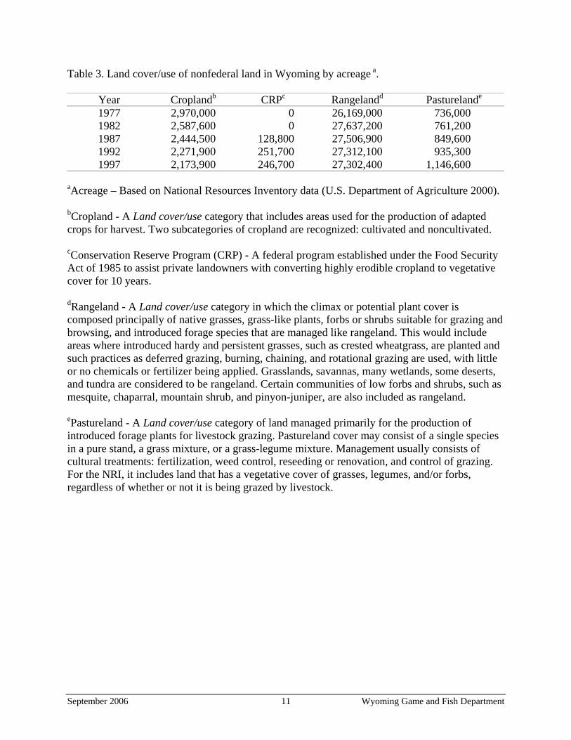
Table 3. Land cover/use of nonfederal land in Wyoming by acreage a.
Year Croplandb CRPc Rangelandd Pasturelande
1977 2,970,000 0 26,169,000 736,000 1982 2,587,600 0 27,637,200 761,200 1987 2,444,500 128,800 27,506,900 849,600 1992 2,271,900 251,700 27,312,100 935,300 1997 2,173,900 246,700 27,302,400 1,146,600
aAcreage – Based on National Resources Inventory data (U.S. Department of Agriculture 2000). bCropland - A Land cover/use category that includes areas used for the production of adapted crops for harvest. Two subcategories of cropland are recognized: cultivated and noncultivated. cConservation Reserve Program (CRP) - A federal program established under the Food Security Act of 1985 to assist private landowners with converting highly erodible cropland to vegetative cover for 10 years. dRangeland - A Land cover/use category in which the climax or potential plant cover is composed principally of native grasses, grass-like plants, forbs or shrubs suitable for grazing and browsing, and introduced forage species that are managed like rangeland. This would include areas where introduced hardy and persistent grasses, such as crested wheatgrass, are planted and such practices as deferred grazing, burning, chaining, and rotational grazing are used, with little or no chemicals or fertilizer being applied. Grasslands, savannas, many wetlands, some deserts, and tundra are considered to be rangeland. Certain communities of low forbs and shrubs, such as mesquite, chaparral, mountain shrub, and pinyon-juniper, are also included as rangeland. ePastureland - A Land cover/use category of land managed primarily for the production of introduced forage plants for livestock grazing. Pastureland cover may consist of a single species in a pure stand, a grass mixture, or a grass-legume mixture. Management usually consists of cultural treatments: fertilization, weed control, reseeding or renovation, and control of grazing. For the NRI, it includes land that has a vegetative cover of grasses, legumes, and/or forbs, regardless of whether or not it is being grazed by livestock.
September 2006 11 Wyoming Game and Fish Department
PROPOSED CONSERVATION ACTIONS
Proposed conservation actions include use of various incentive programs for private landowners and cooperative programs with BLM, NRCS, United States Fish and Wildlife Service (USFWS), and United States Forest Service (USFS) to accomplish the following conservation actions. The indirect and direct effects of the proposed actions on other grassland wildlife, including threatened and endangered plant and animal species, will also be evaluated, with necessary precautions and adjustments incorporated into site-specific management plans.
1. Increase grassland heterogeneity by:
a. introducing fire back into grassland systems via patch burning plans; b. encouraging grazing strategies that also favor habitats for native vegetation and
sensitive wildlife species; and c. introducing disturbance via mechanical treatments.
2. Develop cooperative agreements with willing landowners to manage, maintain, and
prevent habitat fragmentation and conversion in those grassland habitats that are integral for maintaining grassland habitat diversity and grassland obligate wildlife species. This action is especially important for the Western Great Plains Shortgrass Prairie Ecological System.
3. Continue to work cooperatively with the USDA, NRCS and the Farm Service Agency
(FSA) along with other funding sources to maximize grassland conservation benefits of Farm Bill programs and to develop new grassland conservation opportunities.
4. Continue cooperative efforts to control noxious and invasive plants, especially
cheatgrass, in the Thunder Basin National Grasslands region and the rest of eastern Wyoming.
5. Reseed native grasses and forbs.
6. Develop forage reserve management agreements and make their existence known and
available to provide relief to sensitive grassland communities. This may include, but is not limited to, assisting livestock operators with moving grazing to other areas during times when private land habitat improvement projects are being implemented and/or from areas affected by wildfires, droughts or other natural events to enhance or speed grassland habitat recovery.
7. Where appropriate, encourage the implementation of mitigation measures and/or best
management practices detailed within the Wyoming Game and Fish Commission document Recommendations for development of oil and gas resources within crucial and important wildlife habitats (WGFD 2004).
8. Review management actions proposed by state and federal agencies involving grassland
systems, and work closely with the Wyoming Governor’s office, industry, private land owners, and agency staff during early stages of project planning. Encourage land
September 2006 12 Wyoming Game and Fish Department

managers to undertake landscape-level planning to maintain or enhance grassland communities.
9. Where appropriate, encourage the implementation of conservation actions detailed in
this document’s species accounts, and in the documents Growing Grassland Birds - Best Management Practices (Wyoming Partners in Flight 2002, available online: <http://gf.
state.wy.us/wildlife/nongame/BestManagementPractices/GrowingGrasslandBirds.pdf>) and Grassland Wildlife Species Suggested Conservation Practices (Luce 2003b, available online: <http://www.r6.fws.gov/endspp/hpp/Grassland%20Spp%20 Conservation%20Prac_Final_Draft.pdf>).
September 2006 13 Wyoming Game and Fish Department
RECOMMENDED SUPPORT ACTIONS
Develop a land cover classification map A current land cover classification map of eastern Wyoming will be vital in identifying the distribution of habitat types and ecosystem integrity. Such information will enable the WGFD to systematically prioritize areas for conservation efforts. Additionally, changes in ecosystem integrity over time can be monitored when other land cover classification mapping efforts are conducted in the future. To date, three land cover classification maps have been completed by the WGFD that include portions of the grasslands of eastern Wyoming. These maps were done in the Sheridan, Casper, and Laramie regions. However, these mapping efforts only cover a portion of the areas encompassed by this plan. Another land cover classification mapping effort is necessary to catalog the unmapped portions of eastern Wyoming. In order to complete a land cover classification map for all of eastern Wyoming, it will be necessary to obtain a significant amount of funding. A review of the three previous mapping efforts will be necessary to determine whether the data from each map is appropriate for use with the plan. Gori and Enquist (2003) describe an approach to rapidly assess and characterize the extent of vegetative changes to grasslands and to identify the best remaining grasslands and restorable grasslands for an ecological management purpose. Such a study would be extremely beneficial for Wyoming and should be considered a high priority action. Monitor grassland ecosystem integrity Previously, Copeland et al. (2005) developed a habitat intactness index for Wyoming based on 10 criteria: road density; mine presence; oil and gas pipeline presence; oil and gas wells; residential development; dams; impaired streams; aquatic habitat scores; surface water use; and invasive species occurrence. The Copeland et al. (2005) index can be modified with additional information to model grassland ecosystem integrity, monitor grassland habitat trends, and identify priority conservation areas. Work with private landowners (provide outreach, funding, information, and education) The vast majority of grassland in Wyoming is privately owned. Therefore, an essential element in conserving Wyoming’s grasslands is working with private landowners. The Nongame Section of WGFD has developed relationships with numerous landowners in eastern Wyoming during years of conducting monitoring activities on private properties. To adequately monitor grassland species, outreach efforts must be expanded to identify landowners interested in cooperating with the WGFD. Landowner partnerships provide valuable information and strengthen the overall inventory and monitoring program. The Department recognizes the importance of protecting landowners’ privacy and ensuring that their cooperation does not put their livelihood at risk. Educational materials including a homepage on the WGFD website, a fact sheet, and a brochure will also be developed to provide landowners and other interested parties with information about grassland species of concern, including options and tools available to promote their conservation.
September 2006 14 Wyoming Game and Fish Department
A new contract position, the Prairie Ecologist/Terrestrial LIP Coordinator, was recently added to the Nongame Section and will promote these efforts. This position is primarily focused on implementing this conservation plan by seeking opportunities with private landowners interested in participating in conservation efforts that benefit grassland wildlife. The current opportunity for private landowners to work with WGFD habitat extension biologists and NRCS field offices will also be maintained. Efforts will also be made to develop new outreach mechanisms, such as adding a link to the WGFD website with information on funding programs and management options for landowners and press releases. Opportunities already exist in northeastern Wyoming near Thunder Basin National Grassland. A coalition of private landowners from the area formed the Thunder Basin Grassland Prairie Ecosystem Association (TBGPEA) with the objective of maintaining responsible economic use of the landscape while demonstrating how effective stewardship of natural resources can be provided through voluntary, privately-led, collaborative efforts (TBGPEA, Unpublished Report). Current members of TBGPEA own more than 270,000 acres of land. The formation of a landowner group responsible for such a large amount of the landscape that is interested in the conservation of ‘at-risk’ species clearly indicates that opportunities are available for large-scale conservation efforts. Financial incentives will be necessary to encourage landowners to conserve habitat specifically for wildlife. Multiple state and federal agencies and private organizations offer funding programs for habitat conservation (Table 4) that can be used to fund grassland conservation activities. Specific examples include the WGFD’s Landowner Incentive Program (Table 5) and the multiple programs the NRCS offers (Table 6), which have different objectives, incentive payments, and cost share rates. Additional goals for working with landowners include providing assistance and expertise to implement various management activities that will benefit wildlife, public education about the role of prairie dogs and their value to the ecosystem, and obtaining permission to access private lands for monitoring efforts. Build partnerships Continuing to build partnerships with organizations that have similar interests is vital to the successful conservation of Wyoming’s grasslands. Some of the organizations the WGFD has partnered with in the past include other state wildlife agencies, the Audubon Society, BLM, Intermountain West Joint Ventures (IWJV), NRCS, Northern Great Plains Joint Ventures (NGPJV), Petroleum Association of Wyoming, Prairie Partners (PP), Rocky Mountain Bird Observatory (RMBO), The Nature Conservancy (TNC), USFS, USFWS, and the Wyoming Mining Association. When applying for grants, partnerships commonly increase the likelihood of funding. Additionally, partnerships allow resources to be pooled and thereby increase the size of projects and chances for success. The effectiveness of the WGFD’s current partnerships in conserving grassland habitat can be strengthened by:
a. expanding outreach efforts to include additional conservation partners such as agricultural organizations;
b. providing additional technical assistance and education outreach to all partners; and c. targeting funding, technical assistance, and outreach to rare grassland species.
September 2006 15 Wyoming Game and Fish Department
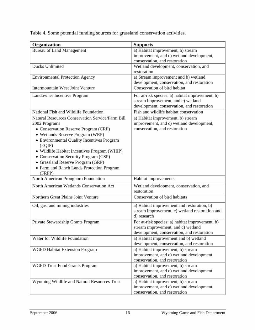
Table 4. Some potential funding sources for grassland conservation activities. Organization Supports Bureau of Land Management a) Habitat improvement, b) stream
improvement, and c) wetland development, conservation, and restoration
Ducks Unlimited Wetland development, conservation, and restoration
Environmental Protection Agency a) Stream improvement and b) wetland development, conservation, and restoration
Intermountain West Joint Venture Conservation of bird habitat Landowner Incentive Program For at-risk species: a) habitat improvement, b)
stream improvement, and c) wetland development, conservation, and restoration
National Fish and Wildlife Foundation Fish and wildlife habitat conservation Natural Resources Conservation Service/Farm Bill 2002 Programs
• Conservation Reserve Program (CRP) • Wetlands Reserve Program (WRP) • Environmental Quality Incentives Program
(EQIP) • Wildlife Habitat Incentives Program (WHIP) • Conservation Security Program (CSP) • Grassland Reserve Program (GRP) • Farm and Ranch Lands Protection Program
(FRPP)
a) Habitat improvement, b) stream improvement, and c) wetland development, conservation, and restoration
North American Pronghorn Foundation Habitat improvements North American Wetlands Conservation Act Wetland development, conservation, and
restoration Northern Great Plains Joint Venture Conservation of bird habitats
Oil, gas, and mining industries a) Habitat improvement and restoration, b) stream improvement, c) wetland restoration and d) research
Private Stewardship Grants Program For at-risk species: a) habitat improvement, b) stream improvement, and c) wetland development, conservation, and restoration
Water for Wildlife Foundation a) Habitat improvement and b) wetland development, conservation, and restoration
WGFD Habitat Extension Program a) Habitat improvement, b) stream improvement, and c) wetland development, conservation, and restoration
WGFD Trust Fund Grants Program a) Habitat improvement, b) stream improvement, and c) wetland development, conservation, and restoration
Wyoming Wildlife and Natural Resources Trust a) Habitat improvement, b) stream improvement, and c) wetland development, conservation, and restoration
September 2006 16 Wyoming Game and Fish Department
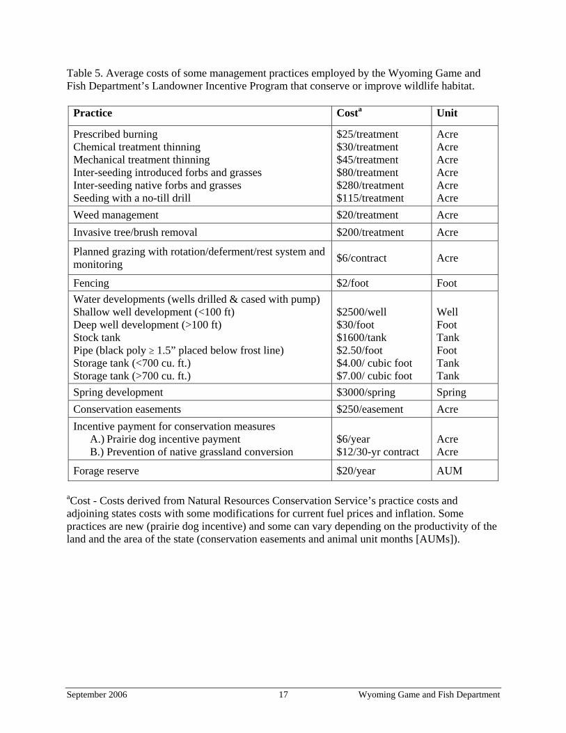
Table 5. Average costs of some management practices employed by the Wyoming Game and Fish Department’s Landowner Incentive Program that conserve or improve wildlife habitat.
Practice Costa Unit
Prescribed burning Chemical treatment thinning Mechanical treatment thinning Inter-seeding introduced forbs and grasses Inter-seeding native forbs and grasses Seeding with a no-till drill
$25/treatment $30/treatment $45/treatment $80/treatment $280/treatment $115/treatment
Acre Acre Acre Acre Acre Acre
Weed management $20/treatment Acre Invasive tree/brush removal $200/treatment Acre
Planned grazing with rotation/deferment/rest system and monitoring $6/contract Acre
Fencing $2/foot Foot Water developments (wells drilled & cased with pump) Shallow well development (<100 ft) Deep well development (>100 ft) Stock tank Pipe (black poly ≥ 1.5” placed below frost line) Storage tank (<700 cu. ft.) Storage tank (>700 cu. ft.)
$2500/well $30/foot $1600/tank $2.50/foot $4.00/ cubic foot $7.00/ cubic foot
Well Foot Tank Foot Tank Tank
Spring development $3000/spring Spring Conservation easements $250/easement Acre Incentive payment for conservation measures
A.) Prairie dog incentive payment B.) Prevention of native grassland conversion
$6/year $12/30-yr contract
Acre Acre
Forage reserve $20/year
aCost - Costs derived from Natural Resources Conservation Service’s practice costs and adjoining states costs with some modifications for current fuel prices and inflation. Some practices are new (prairie dog incentive) and some can vary depending on the productivity of the land and the area of the state (conservation easements and animal unit months [AUMs]).
AUM
September 2006 17 Wyoming Game and Fish Department
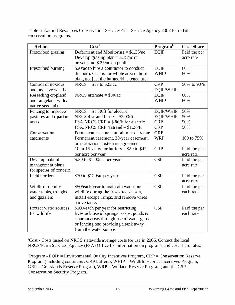
Table 6. Natural Resources Conservation Service/Farm Service Agency 2002 Farm Bill conservation programs. Action Costa Programb Cost-Share Prescribed grazing Deferment and Monitoring = $1.25/ac
Develop grazing plan = $.75/ac on private and $.25/ac on public
EQIP Paid the per acre rate
Prescribed burning $20/ac to hire a contractor to conduct the burn. Cost is for whole area in burn plan, not just the burned/blackened area
EQIP WHIP
60% 60%
Control of noxious and invasive weeds
NRCS = $13 to $25/ac
CRP EQIP/WHIP
50% to 90%
Reseeding cropland and rangeland with a native seed mix
NRCS estimate = $80/ac
EQIP WHIP
60% 60%
Fencing to improve pastures and riparian areas
NRCS = $1.50/ft for electric NRCS 4 strand fence = $2.00/ft FSA/NRCS CRP = $.86/ft for electric FSA/NRCS CRP 4 strand = $1.26/ft
EQIP/WHIP EQIP/WHIP CRP CRP
50% 50% 90% 90%
Conservation easements
Permanent easement at fair market value Permanent easement, 30-year easement, or restoration cost-share agreement 10 or 15 years for buffers = $29 to $42 per acre per year
GRP WRP CRP
100 to 75% Paid the per acre rate
Develop habitat management plans for species of concern
$.50 to $1.00/ac per year CSP Paid the per acre rate
Field borders $70 to $120/ac per year CSP Paid the per acre rate
Wildlife friendly water tanks, troughs and guzzlers
$50/each/year to maintain water for wildlife during the frost-free season, install escape ramps, and remove wires above tanks
CSP Paid the per each rate
Protect water sources for wildlife
$200/each per year for restricting livestock use of springs, seeps, ponds & riparian areas through use of water gaps or fencing and providing a tank away from the water source
CSP Paid the per each rate
aCost - Costs based on NRCS statewide average costs for use in 2006. Contact the local NRCS/Farm Services Agency (FSA) Office for information on programs and cost-share rates. bProgram - EQIP = Environmental Quality Incentives Program, CRP = Conservation Reserve Program (including continuous CRP buffers), WHIP = Wildlife Habitat Incentives Program, GRP = Grasslands Reserve Program, WRP = Wetland Reserve Program, and the CSP = Conservation Security Program.
September 2006 18 Wyoming Game and Fish Department
SPECIES OF GREATEST CONSERVATION NEED – SPECIES ACCOUNTS The WGFD developed the Native Species Status (NSS) matrix (Oakleaf et al. 1996, WGFD 2005, Appendix B) during the early 1980s to identify species of special concern. This classification system involves reviewing species’ status based on population and habitat variables. For this plan, the NSS matrix was used to prioritize grassland species for conservation attention (Table 7). The WGFD will focus its management efforts on species identified as NSS1, NSS2, NSS3, and NSS4. A ranking of NSS1, NSS2, or NSS3 indicates that populations are restricted in numbers and distribution or that population declines, habitat declines, or both have been observed and documented. NSS4 species were included to identify species that are high priority for additional research and monitoring. In many cases, NSS4 species are species that may be secure in Wyoming but have been extirpated or have suffered population declines in other states. It is prudent to proactively address their conservation needs and potential threats to the long-term viability of those species. The Upland Sandpiper, a NSS4 species, is of particular concern in Wyoming because its range has been restricted due to habitat loss and decreased grassland heterogeneity, and its population numbers have been significantly reduced in other states, including some of Wyoming’s neighbors (Houston and Bowen 2001). Table 7. Grassland species of greatest conservation need in Wyoming.
Species Native Species Status Species Account Page Black-footed ferret NSS1 18 Black-tailed prairie dog NSS3 21 White-tailed prairie dog NSS4 25 Swift fox NSS4 28 Hispid pocket mouse NSS3 31 Olive-backed pocket mouse NSS3 31 Plains harvest mouse NSS3 31 Plains pocket mouse NSS3 31 Prairie vole NSS3 31 Plains pocket gopher NSS4 31 Mountain Plover NSS4 32 Burrowing Owl NSS4 35 Ferruginous Hawk NSS3 38 Long-billed Curlew NSS3 41 Upland Sandpiper NSS4 44 Chestnut-collared Longspur NSS4 46 Lark Bunting NSS4 46 McCown’s Longspur NSS4 46 Bobolink NSS4 46 Dickcissel NSS4 46 Grasshopper Sparrow NSS4 46 Short-eared Owl NSS4 46
September 2006 19 Wyoming Game and Fish Department
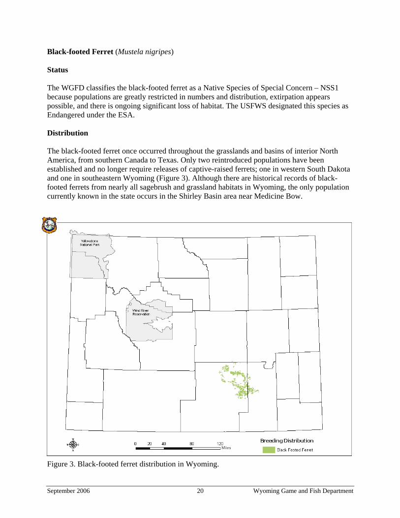
Black-footed Ferret (Mustela nigripes) Status The WGFD classifies the black-footed ferret as a Native Species of Special Concern – NSS1 because populations are greatly restricted in numbers and distribution, extirpation appears possible, and there is ongoing significant loss of habitat. The USFWS designated this species as Endangered under the ESA. Distribution The black-footed ferret once occurred throughout the grasslands and basins of interior North America, from southern Canada to Texas. Only two reintroduced populations have been established and no longer require releases of captive-raised ferrets; one in western South Dakota and one in southeastern Wyoming (Figure 3). Although there are historical records of black-footed ferrets from nearly all sagebrush and grassland habitats in Wyoming, the only population currently known in the state occurs in the Shirley Basin area near Medicine Bow.
Figure 3. Black-footed ferret distribution in Wyoming.
September 2006 20 Wyoming Game and Fish Department
Abundance The black-footed ferret has low abundance in Wyoming and is considered rare. The black-footed ferret was once thought to be extinct in North America, but was discovered in a prairie dog colony near Meeteetse, Wyoming in 1981. Canine distemper and sylvatic plague decimated the population in 1986 and 1987. The 18 surviving ferrets were captured and became the founder population for a cooperative captive breeding effort (WGFD 1987, Thorne and Oakleaf 1991). The captive breeding program provided ferrets for reintroduction at 9 sites in the western U.S. and Mexico. From 1991–1994, 228 black-footed ferrets were released in Shirley Basin, near Medicine Bow, Wyoming according to WGFD management objective and strategies (SB/MB-BFWG 1991). WGFD Shirley Basin ferret surveys detected a minimum of 51 ferrets in 2003 (Grenier et al. 2004c) and 88 ferrets during the annual survey in August 2004 (Grenier et al. 2005). Survey results for 2005 indicate more than 149 ferrets are present in Shirley Basin. Habitat The black-footed ferret is found almost exclusively on prairie dog colonies in basin-prairie shrublands, sagebrush-grasslands, and grasslands. It depends on prairie dogs for food and all essential aspects of its habitat. It spends a large portion of its time in prairie dog burrows. Problems • Human prairie dog control efforts directly coincided with the demise of the black-footed
ferret. • Epizootics of sylvatic plague and canine distemper hamper and minimize the potential for
successful reintroduction under current management paradigms. • Successful reintroduction efforts are limited by the availability of captive-raised ferrets,
inadequate funding, and protocol that is cumbersome, cost-ineffective, and out-of-date. • Funding has been inadequate to annually monitor the ferret population and habitat in the
Shirley Basin/Medicine Bow Black-footed Ferret Management Area. • Prairie dog control efforts and the needs of many livestock producers limit the number of
potential reintroduction sites for the black-footed ferret. Recent petitions to list prairie dogs under the ESA caused localized increases in control efforts and disabled cooperative programs with some private landowners.
Proposed Actions • Develop and maintain at least two wild black-footed ferret populations in Wyoming,
including the population in Shirley Basin (WGFD 1987). • Continue to monitor the Shirley Basin ferret population, the status of its habitat, and diseases. • Evaluate ferret habitat by monitoring prairie dog colonies in the Shirley Basin Management
Area. • Evaluate the potential and need for future translocations into the Shirley Basin/Medicine
Bow Management Area to minimize the loss of genetic diversity in the ferret population. • Develop a cooperative management program for prairie dogs and associated grassland
species in Wyoming.
September 2006 21 Wyoming Game and Fish Department
• Continue to coordinate with the USFWS to determine the availability of captive-raised ferrets and assist in developing a streamlined, cost-effective reintroduction program in Wyoming to expand the population’s distribution and reduce the risk of catastrophic loss or extirpation caused by epizootics.
• Evaluate prairie dog habitat and evaluate reintroduction potential in order to identify additional reintroduction sites in Wyoming.
• Evaluate the potential to use the captive breeding and conditioning facilities at Sybille Wildlife Conservation Center after the USFWS relocates to another facility.
Monitoring Strategy The objective is to determine the distribution and trend of the black-footed ferret population in Shirley Basin. Spotlighting surveys are conducted in mid to late August and September. Consult Grenier (2005) for survey methodologies. It is anticipated that WGFD personnel will monitor the black-footed ferret population in Shirley Basin on an annual basis and possibly at three-year intervals in the future. Monitoring schedules for additional release sites will likely mimic the Shirley Basin efforts.
September 2006 22 Wyoming Game and Fish Department
Black-tailed Prairie Dog (Cynomys ludovicianus) Status The WGFD classifies the black-tailed prairie dog as a Native Species of Special Concern – NSS3 because populations have declined and habitat is vulnerable, but there is no ongoing significant habitat loss. When the black-tailed prairie dog was petitioned for listing under the ESA in 1998, 11 states within the range of the black-tailed prairie dog began a multi-state conservation effort for the species. A multi-state conservation plan for the black-tailed prairie dog (Luce 2003a) was developed to provide guidelines under which individual states and their respective working groups developed management plans. In August 2004, as a result of additional information provided by the WGFD and conservation measures implemented by the Intrastate Black-tailed Prairie Dog Conservation Team, the USFWS removed the black-tailed prairie dog from the Candidate List of the ESA. Distribution Historically, the black-tailed prairie dog occurred throughout the Great Plains states from Canada to Mexico and west to southeastern Arizona, although it is now uncommon or extirpated from much of its former range in adjacent states (Hoogland 2003). In Wyoming, it occurs in the eastern third of the state at elevations below 1,700 m (5,600 ft.) (Figure 4). The Wyoming counties within the primary range of the black-tailed prairie dog are Campbell, Converse, Crook, Goshen, Johnson, Laramie, Natrona, Niobrara, Platte, Sheridan, and Weston. Abundance The black-tailed prairie dog is considered common in Wyoming (Table 8), although its abundance fluctuates primarily with activity levels of sylvatic plague and the extent of control efforts by landowners (Miller and Cully 2001, Luce 2003a). Mapping conducted by the WGFD between 1982 and 1987 indicated a minimum of 53,055 ha (131,000 ac) of black-tailed prairie dog colonies with a statewide estimate ranging up to 82,620 ha (204,000 ac) (Oakleaf et al. 1996). Mapping of colonies using color infrared photographs from the 2001/2002 National Aerial Photography program documented more than 92,675 ha (229,000 ac) of black-tailed prairie dog colonies (Grenier et al. 2004a). Comparisons with 1994 Digital Ortho Quads indicated that black-tailed prairie dog acreage had remained stable from 1994 through 2001. However, aerial surveys conducted in 2003 to determine the status of all known colonies indicated that a significant portion (approximately 47%) of the prairie dog acreage was impacted by sylvatic plague and/or control efforts (Grenier et al. 2004b). Preliminary estimates from an ongoing survey indicate that a minimum of 86,270 ha (213,174 ac) of black-tailed prairie dogs colonies are present in Wyoming (Grenier et al. 2004a). Of the 1,986 colonies identified thus far, 53% were classified as healthy for an estimated 41,572 ha (102,725 ac), 38% were classified as impacted for an estimated 36,804 ha (90,945 ac), and 9% are currently classified as unknown for an estimated 6,790 ha (16,780 ac) (Grenier et al. 2004b).
September 2006 23 Wyoming Game and Fish Department
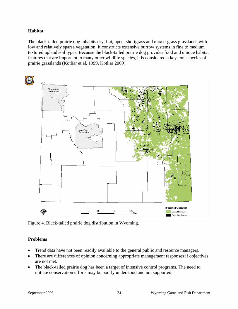
Habitat The black-tailed prairie dog inhabits dry, flat, open, shortgrass and mixed-grass grasslands with low and relatively sparse vegetation. It constructs extensive burrow systems in fine to medium textured upland soil types. Because the black-tailed prairie dog provides food and unique habitat features that are important to many other wildlife species, it is considered a keystone species of prairie grasslands (Kotliar et al. 1999, Kotliar 2000).
Figure 4. Black-tailed prairie dog distribution in Wyoming. Problems • Trend data have not been readily available to the general public and resource managers. • There are differences of opinion concerning appropriate management responses if objectives
are not met. • The black-tailed prairie dog has been a target of intensive control programs. The need to
initiate conservation efforts may be poorly understood and not supported.
September 2006 24 Wyoming Game and Fish Department
• Sylvatic plague, an exotic disease, has the potential to have substantial negative impacts on prairie dog populations. There are currently no effective means to mitigate the spread of plague.
Proposed Actions • Maintain 219,000 total acres of black-tailed prairie dog colonies, with at least 100,000
‘healthy’ acres. ‘Healthy’ indicates that > 50% of a colony is active. ‘Impacted’ indicates that < 50% of a colony is active.
• Continue to evaluate monitoring results to assure that objectives in the multi-state conservation plan for the black-tailed prairie dog (Luce 2003a) are being maintained.
• If monitoring data show that objectives are not being met, provide information to the Wyoming Game and Fish Commission to allow them to evaluate and consider an appropriate response, such as regulating shooting pressure, or implementing a memorandum of understanding with the Wyoming Board of Agriculture and the Wyoming Weed and Pest Council that limits the distribution of toxicants and their use in control programs.
• Continue inventories and monitoring efforts recently developed and recommended by Grenier et al. (2004b, c).
• As part of a planned grassland conservation program, provide assistance and incentives to landowners to conserve prairie dogs and their habitat. WGFD assistance and incentives to landowners for prairie dog conservation will include precautions and agreements to prevent dispersal and establishment of unwanted prairie dogs onto adjacent private land, including at least a 0.5-mile buffer between maintained colonies and neighbors who do not want prairie dogs on their property. In addition, normal safeguards provided by the Wyoming Weed and Pest Act of 1973 should assure adjacent landowners that they will not be impacted by increasing prairie dog populations. Article 1, Section 9 of the act states, “Whenever the district board has probable cause to believe that there exists land infested by weeds or pests which are liable to spread and contribute to the injury or detriment of others, it shall make or have made an investigation of the suspected premises through the use of lawful entry procedures…. If the suspected area is found to be infested, the district board, by resolution adopted by two-thirds (2/3) of its members, shall confirm such fact. The district board may set forth minimum remedial requirements for control of the infested area” (Wyoming State Statute 11-5-109, Wyoming State Legislature 2005).
• Federal and state land management agencies participating in a grassland conservation program should provide the necessary control to prevent dispersal and establishment of unwanted prairie dogs onto adjacent private land.
• Develop information about the ecological value of prairie dogs and their role as keystone species (Campbell and Clark 1981) to build support for developing and implementing an effective management program.
• Give priority and special management attention to prairie dog complexes of at least 2000 ha (5000 ac), since these large complexes are integral to the black-tailed prairie dog’s ecology and are important habitats for many associated or dependent species.
September 2006 25 Wyoming Game and Fish Department
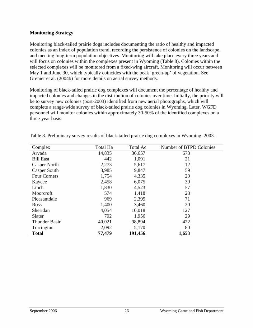
Monitoring Strategy Monitoring black-tailed prairie dogs includes documenting the ratio of healthy and impacted colonies as an index of population trend, recording the persistence of colonies on the landscape, and meeting long-term population objectives. Monitoring will take place every three years and will focus on colonies within the complexes present in Wyoming (Table 8). Colonies within the selected complexes will be monitored from a fixed-wing aircraft. Monitoring will occur between May 1 and June 30, which typically coincides with the peak ‘green-up’ of vegetation. See Grenier et al. (2004b) for more details on aerial survey methods. Monitoring of black-tailed prairie dog complexes will document the percentage of healthy and impacted colonies and changes in the distribution of colonies over time. Initially, the priority will be to survey new colonies (post-2003) identified from new aerial photographs, which will complete a range-wide survey of black-tailed prairie dog colonies in Wyoming. Later, WGFD personnel will monitor colonies within approximately 30-50% of the identified complexes on a three-year basis. Table 8. Preliminary survey results of black-tailed prairie dog complexes in Wyoming, 2003. Complex Total Ha Total Ac Number of BTPD Colonies Arvada 14,835 36,657 673 Bill East 442 1,091 21 Casper North 2,273 5,617 12 Casper South 3,985 9,847 59 Four Corners 1,754 4,335 29 Kaycee 2,458 6,075 30 Linch 1,830 4,523 57 Moorcroft 574 1,418 23 Pleasantdale 969 2,395 71 Ross 1,400 3,460 20 Sheridan 4,054 10,018 127 Slater 792 1,956 29 Thunder Basin 40,021 98,894 422 Torrington 2,092 5,170 80 Total 77,479 191,456 1,653
September 2006 26 Wyoming Game and Fish Department
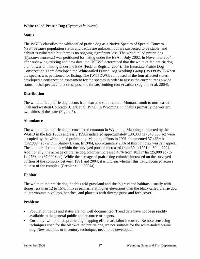
White-tailed Prairie Dog (Cynomys leucurus) Status The WGFD classifies the white-tailed prairie dog as a Native Species of Special Concern – NSS4 because population status and trends are unknown but are suspected to be stable, and habitat is vulnerable but there is no ongoing significant loss. The white-tailed prairie dog (Cynomys leucurus) was petitioned for listing under the ESA in July 2002. In November 2004, after reviewing existing and new data, the USFWS determined that the white-tailed prairie dog did not warrant listing under the ESA (Federal Register 2004). The Interstate Prairie Dog Conservation Team developed the White-tailed Prairie Dog Working Group (IWTPDWG) when the species was petitioned for listing. The IWTPDWG, composed of the four affected states, developed a conservation assessment for the species in order to assess the current, range-wide status of the species and address possible threats limiting conservation (Seglund et al. 2004). Distribution The white-tailed prairie dog occurs from extreme south-central Montana south to northeastern Utah and western Colorado (Clark et al. 1971). In Wyoming, it inhabits primarily the western two-thirds of the state (Figure 5). Abundance The white-tailed prairie dog is considered common in Wyoming. Mapping conducted by the WGFD in the late 1980s and early 1990s indicated approximately 138,000 ha (340,000 ac) were occupied by the white-tailed prairie dog. Mapping efforts in 1991 documented 57,465+ ha (142,000+ ac) within Shirley Basin. In 2004, approximately 20% of this complex was remapped. The number of colonies within the surveyed portion increased from 30 in 1991 to 60 in 2004. Additionally, the acreage of prairie dog colonies increased 48% from 10,117 ha (25,000 ac) to 14,973+ ha (37,000+ ac). While the acreage of prairie dog colonies increased on the surveyed portion of the complex between 1991 and 2004, it is unclear whether this trend occurred across the rest of the complex (Grenier et al. 2004a). Habitat The white-tailed prairie dog inhabits arid grassland and shrub/grassland habitats, usually with slopes less than 12 to 15%. It lives primarily at higher elevations than the black-tailed prairie dog in intermountain valleys, benches, and plateaus with diverse grass and forb cover. Problems • Population trends and status are not well documented. Trend data have not been readily
available to the general public and resource managers. • Currently, white-tailed prairie dog mapping efforts are labor intensive. Remote censusing
techniques used for the black-tailed prairie dog are not suitable for the white-tailed prairie dog. New methods or inventory techniques need to be developed.
September 2006 27 Wyoming Game and Fish Department

• Sylvatic plague has the potential to have substantial negative impacts on prairie dog populations. There are currently no effective means to mitigate the spread of plague.
• The white-tailed prairie dog is listed as a pest under Wyoming’s Weed and Pest Act, and recreational shooting activity is not regulated or monitored by the Wyoming Game and Fish Department.
• Impacts of natural resource development such as oil and gas are not quantified and preclude effective management.
Figure 5. White-tailed prairie dog distribution in Wyoming.
Proposed Actions • White-tailed prairie dog conservation actions described in this plan are primarily intended to
take place in Albany and Carbon counties due to the plan’s focus on conservation of grassland ecosystems.
September 2006 28 Wyoming Game and Fish Department

• Initiate inventories and monitoring to more accurately estimate white-tailed prairie dog population levels and evaluate trends. Develop agreements and funding to initiate statewide monitoring and inventory efforts.
• The BLM has outlined conservation actions within BLM Resource Management Plans that will likely be used to conserve white-tailed prairie dogs within the Rawlins and Casper districts. The WGFD will attempt to cooperate with the BLM in these areas to develop a statewide coordinated management approach.
• Develop information about the ecological value of prairie dogs and their role as keystone species (Campbell and Clark 1981) to build support for developing and implementing an effective management program.
• Give priority and special management attention to prairie dog complexes of at least 2,000 ha (5,000 ac), since these large complexes are integral to the white-tailed prairie dog’s ecology and are important habitats for many associated or dependent species.
Monitoring Strategy The objective is to monitor the acreage occupied by white-tailed prairie dogs within the Shirley Basin/Medicine Bow Black-footed Ferret Management Area. Consult Biggens et al. (1993) for detailed mapping and surveying protocols. Surveys will be completed every three to five years.
September 2006 29 Wyoming Game and Fish Department
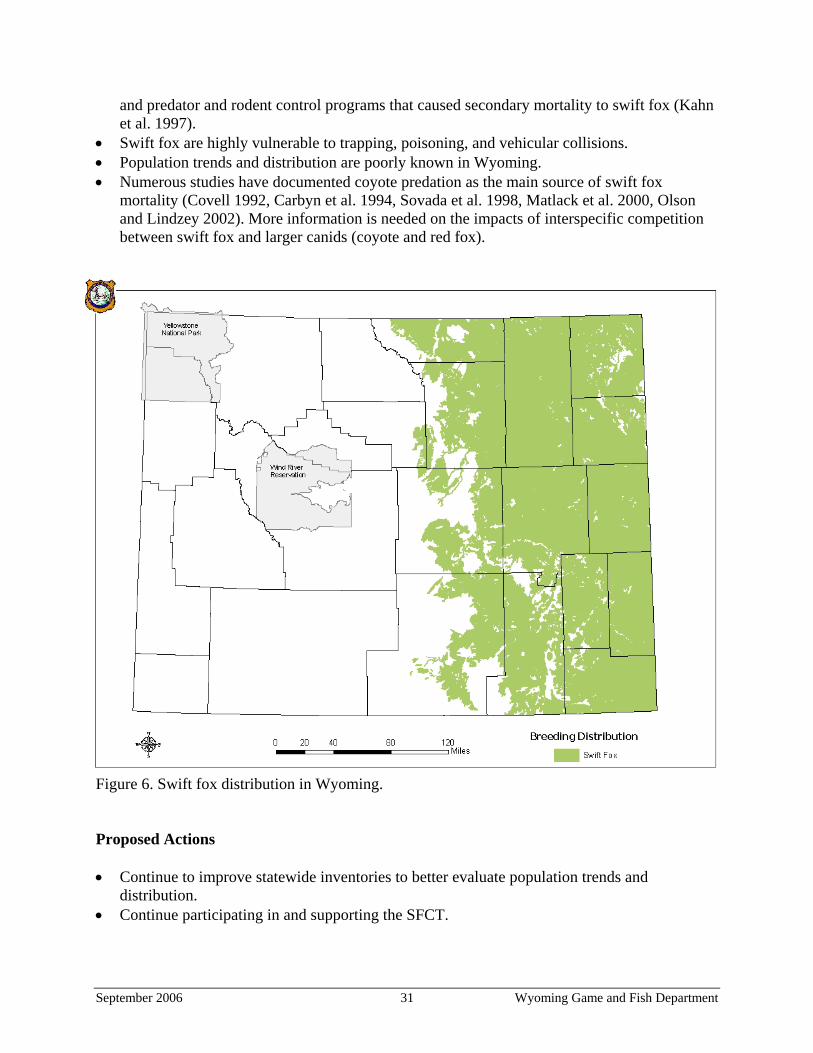
Swift Fox (Vulpes velox) Status The WGFD classifies the swift fox as a Native Species of Special Concern – NSS4 because population status and trends are unknown but are suspected to be stable, and because its habitat is vulnerable, but there is no ongoing significant loss. The species was petitioned for listing under the ESA in 1993. The ten state wildlife management agencies within the range of the swift fox responded by forming the Swift Fox Conservation Team (SFCT) in 1994. The SFCT developed a species conservation assessment and conservation strategy to provide a framework to direct conservation of the species as an alternative to a federally mandated recovery effort (Kahn et al. 1997). As a result of additional information and conservation measures implemented by the WGFD and the SFCT, the USFWS determined that the species did not warrant listing and removed the species from the Candidate List of the ESA in 2002. Distribution Historically, the swift fox inhabited southern Saskatchewan and Alberta south across Montana and the Dakotas through the Great Plains states to northwestern Texas and eastern New Mexico (Egoscue 1979). It is now extirpated or uncommon in some parts of that range. In Wyoming, the swift fox is native to the grassland prairies, and it primarily occurs east of the continental divide (Figure 6). The swift fox has been documented in 16 of the state’s 28 latilongs, with confirmed or probable breeding in 13 latilongs (Appendix C). Abundance The swift fox is considered common in Wyoming. While conducting spotlighting surveys in Shirley Basin in 1997, 2000, 2001, 2003, and 2004, swift fox detections on survey routes varied between 64.3−84% (Table 9). The data were collected while conducting spotlight surveys for the black-footed ferret and swift fox. The analysis was performed by only evaluating transects where swift fox were detected at least once between 1997 and 2004. Habitat The swift fox primarily inhabits shortgrass and mixed-grass prairies, although it often uses highway and railroad right-of-ways, agricultural areas, and sagebrush-grasslands. It is closely associated with prairie dog colonies and uses underground dens year-round. It selects habitat with low-growing vegetation, relatively flat terrain, friable soils, and high availability of den sites.
Problems • Anthropogenic activities in the early 1800s through the mid 1900s contributed to the recent
restricted distribution and abundance of swift foxes throughout their range. Some of these activities include the conversion of native prairie habitat, unregulated trapping and hunting,
September 2006 30 Wyoming Game and Fish Department
and predator and rodent control programs that caused secondary mortality to swift fox (Kahn et al. 1997).
• Swift fox are highly vulnerable to trapping, poisoning, and vehicular collisions. • Population trends and distribution are poorly known in Wyoming. • Numerous studies have documented coyote predation as the main source of swift fox
mortality (Covell 1992, Carbyn et al. 1994, Sovada et al. 1998, Matlack et al. 2000, Olson and Lindzey 2002). More information is needed on the impacts of interspecific competition between swift fox and larger canids (coyote and red fox).
Figure 6. Swift fox distribution in Wyoming. Proposed Actions • Continue to improve statewide inventories to better evaluate population trends and
distribution. • Continue participating in and supporting the SFCT.
September 2006 31 Wyoming Game and Fish Department
• Identify areas with important habitat and habitat corridors. Also, identify areas where habitat conservation and management efforts should focus to protect, enhance, or improve suitable habitat.
• Develop and maintain a positive relationship with landowners that provide habitat for swift fox. Promote beneficial land use practices and management for swift fox on private land.
• Determine the effects of interspecific competition with red foxes and coyotes. • Integrate management of the swift fox with other native species of special concern that
depend on grasslands, such as the black-footed ferret, Ferruginous Hawk, Mountain Plover, black-tailed prairie dog, and Burrowing Owl.
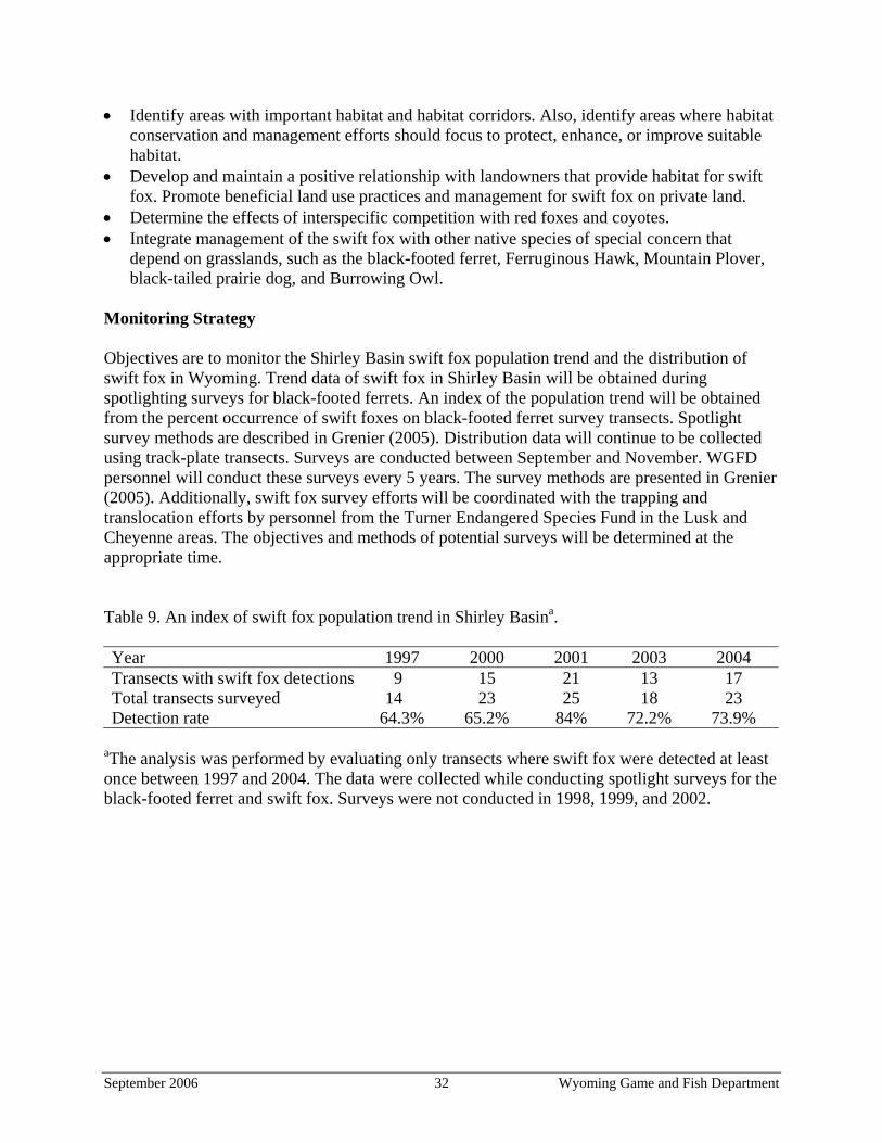
Monitoring Strategy Objectives are to monitor the Shirley Basin swift fox population trend and the distribution of swift fox in Wyoming. Trend data of swift fox in Shirley Basin will be obtained during spotlighting surveys for black-footed ferrets. An index of the population trend will be obtained from the percent occurrence of swift foxes on black-footed ferret survey transects. Spotlight survey methods are described in Grenier (2005). Distribution data will continue to be collected using track-plate transects. Surveys are conducted between September and November. WGFD personnel will conduct these surveys every 5 years. The survey methods are presented in Grenier (2005). Additionally, swift fox survey efforts will be coordinated with the trapping and translocation efforts by personnel from the Turner Endangered Species Fund in the Lusk and Cheyenne areas. The objectives and methods of potential surveys will be determined at the appropriate time.
Table 9. An index of swift fox population trend in Shirley Basina. Year 1997 2000 2001 2003 2004 Transects with swift fox detections 9 15 21 13 17 Total transects surveyed 14 23 25 18 23 Detection rate 64.3% 65.2% 84% 72.2% 73.9%
aThe analysis was performed by evaluating only transects where swift fox were detected at least once between 1997 and 2004. The data were collected while conducting spotlight surveys for the black-footed ferret and swift fox. Surveys were not conducted in 1998, 1999, and 2002.
September 2006 32 Wyoming Game and Fish Department
Other Grassland Mammals Status The WGFD will monitor six other small mammals in addition to the mammals discussed above in the species accounts section. These mammals are the hispid pocket mouse (Chaetodipus hispidus) – NSS3; olive-backed pocket mouse (Perognathus fasciatus) – NSS3; plains harvest mouse (Reithrodontomys montanus) – NSS3; plains pocket mouse (Perognathus flavescens) – NSS3; prairie vole (Microtus ochrogaster) – NSS3; and plains pocket gopher (Geomys bursarius) – NSS4. Distribution maps for each species are presented in Appendix C.
Problems The main problems facing the WGFD with respect to managing these species are that population status, trends, and distribution information are largely unknown, thus precluding effective management. Additionally, there have been no efforts to identify key habitats in Wyoming. Proposed Actions For these mammals, information is needed on species distribution within the potential habitat in Wyoming. After species distributions have been identified, important habitat areas can be delineated and the WGFD can work cooperatively with private landowners to maintain habitat within the designated area. Monitoring Strategy The monitoring strategy is to assess species composition and estimate the relative abundance of these small mammals within grassland communities where previous observations have confirmed their presence. Sites for monitoring will be selected in the future. At least 500 trap-nights of catch effort over a 4-day period are necessary to complete surveys. Trapping stations are spaced 15 meters apart with 4 baited traps at each station (e.g. one live trap, one rat and two mouse museum special snap traps). There are 30 stations per transect. To estimate relative abundance, animals caught in live traps will be marked to prevent recounting. Ear tags are the preferred marking technique. Data are reported as the total number of each species caught and the catch of each species per 100-trap-nights. See Grenier (2005) for more details on methods for trapping small mammals.
September 2006 33 Wyoming Game and Fish Department
Mountain Plover (Charadrius montanus) Status The WGFD classifies the Mountain Plover as a Native Species of Special Concern – NSS4 because population status and trends are unknown but are suspected to be stable, and habitat is vulnerable but there is no ongoing significant loss. This species is also sensitive to human disturbance. The North American Breeding Bird Survey (BBS) did not detect a trend for the Mountain Plover in Wyoming from 1966–2002. However, these data are considered uncertain because the BBS does not effectively monitor species, such as the Mountain Plover, that occur at low densities, and because BBS estimates are much less accurate at fine geographic scales. Distribution The Mountain Plover nests locally in the western Great Plains from Montana south to New Mexico, in Utah, and in Mexico (Knopf 1996). It winters in a broad band from Texas west and north to the Central Valley of California. It occurs throughout most of Wyoming (Figure 7) and has been documented in all of Wyoming’s 28 latilongs, with confirmed or probable (circumstantial evidence of nesting) breeding in 20 latilongs (Appendix C). Abundance The Mountain Plover is considered a common summer resident in Wyoming. Plumb (2004) estimated the statewide population to be approximately 3,400 adults (range 2,270 to 4,430). Within the occupied range in Wyoming, Plumb (2004) identified five concentration areas for breeding Mountain Plovers and estimated Mountain Plover density at 4.47 ± 0.55 birds/km2. Habitat The Mountain Plover inhabits low, open habitats, such as arid shortgrass and mixed-grass prairies dominated by blue grama and buffalograss with scattered clumps of cacti and forbs, and saltbush habitats of the shrub-steppe of central and western Wyoming. It prefers to nest in large, flat grassland expanses with sparse, short vegetation (10 cm [4 in] or less) and bare ground. It is adapted to areas that have been disturbed by prairie dogs, heavy grazing, or fire. Problems • Population trends are not well documented, but the species winters in areas (such as southern
California) that have experienced intensive conversion of native grasslands to cropland and urbanization.
• A narrow range of habitat requirements combined with a high degree of site fidelity increases its vulnerability to impacts at traditional breeding sites (Knopf 1996).
• Important breeding areas for the Mountain Plover in Wyoming are only partially identified, so management efforts and habitat maintenance may not be adequate.
September 2006 34 Wyoming Game and Fish Department
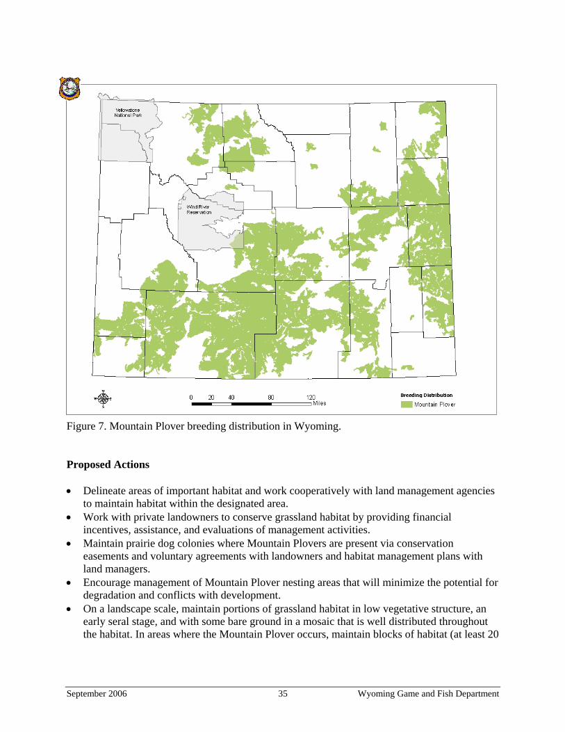
Figure 7. Mountain Plover breeding distribution in Wyoming. Proposed Actions • Delineate areas of important habitat and work cooperatively with land management agencies
to maintain habitat within the designated area. • Work with private landowners to conserve grassland habitat by providing financial
incentives, assistance, and evaluations of management activities. • Maintain prairie dog colonies where Mountain Plovers are present via conservation
easements and voluntary agreements with landowners and habitat management plans with land managers.
• Encourage management of Mountain Plover nesting areas that will minimize the potential for degradation and conflicts with development.
• On a landscape scale, maintain portions of grassland habitat in low vegetative structure, an early seral stage, and with some bare ground in a mosaic that is well distributed throughout the habitat. In areas where the Mountain Plover occurs, maintain blocks of habitat (at least 20
September 2006 35 Wyoming Game and Fish Department
ha [50 ac] in size) consisting of bare ground and up to 70% short, sparse vegetation on nearly level terrain.
• Encourage management of Mountain Plover nesting areas that minimizes insecticide use and human disturbance during the breeding season (early April to mid July).
• Use prescribed burning in late summer or early fall and rotational grazing to promote vegetation and habitat characteristics required by the Mountain Plover.
Monitoring Strategy The objective is to monitor the Mountain Plover population trends in the Shirley and Laramie Basins, the only two concentration areas for breeding Mountain Plovers in Wyoming’s grasslands (Plumb 2004). We will use a survey protocol with guidelines similar to those of USFWS (2002) and Plumb (2004). Transect locations are based on observations from previous surveys (Plumb 2004, Stephens 2005). Surveys are conducted by driving along established routes and making stops at ¼-mile intervals to conduct visual scans. Scans are conducted outside of the vehicle to prompt movement of nesting or resting plovers and to maximize plover detectability. Length of time for each visual scan is not predetermined; rather, each visual scan lasts as long as necessary to cover a 360-degree panorama around the vehicle. Surveys are conducted in the morning between local sunrise and 10:00hr, and in the afternoon between 17:30hr and local sunset to take advantage of horizontal lighting that facilitates detection of plovers. Geographic coordinates, distance to the bird, and angle from the transect are recorded at the site of each Mountain Plover observation. A minimum of 40 detections in both study areas is necessary to estimate population trend. These surveys are conducted during the last two weeks of May (incubation phase) and again during the last two weeks of June through early July (chick- rearing phase). Surveys will be conducted on an annual basis depending on funding and the availability of WGFD personnel to collect data.
September 2006 36 Wyoming Game and Fish Department
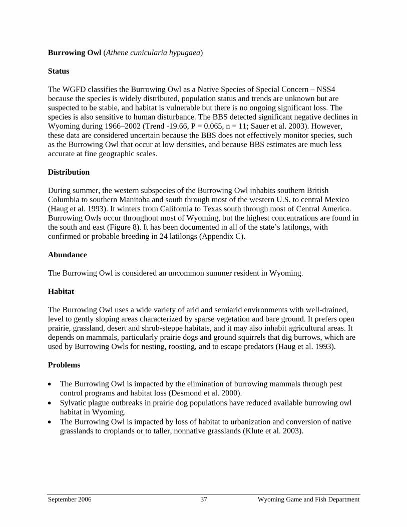
Burrowing Owl (Athene cunicularia hypugaea) Status The WGFD classifies the Burrowing Owl as a Native Species of Special Concern – NSS4 because the species is widely distributed, population status and trends are unknown but are suspected to be stable, and habitat is vulnerable but there is no ongoing significant loss. The species is also sensitive to human disturbance. The BBS detected significant negative declines in Wyoming during 1966–2002 (Trend -19.66, P = 0.065, n = 11; Sauer et al. 2003). However, these data are considered uncertain because the BBS does not effectively monitor species, such as the Burrowing Owl that occur at low densities, and because BBS estimates are much less accurate at fine geographic scales. Distribution During summer, the western subspecies of the Burrowing Owl inhabits southern British Columbia to southern Manitoba and south through most of the western U.S. to central Mexico (Haug et al. 1993). It winters from California to Texas south through most of Central America. Burrowing Owls occur throughout most of Wyoming, but the highest concentrations are found in the south and east (Figure 8). It has been documented in all of the state’s latilongs, with confirmed or probable breeding in 24 latilongs (Appendix C). Abundance The Burrowing Owl is considered an uncommon summer resident in Wyoming. Habitat The Burrowing Owl uses a wide variety of arid and semiarid environments with well-drained, level to gently sloping areas characterized by sparse vegetation and bare ground. It prefers open prairie, grassland, desert and shrub-steppe habitats, and it may also inhabit agricultural areas. It depends on mammals, particularly prairie dogs and ground squirrels that dig burrows, which are used by Burrowing Owls for nesting, roosting, and to escape predators (Haug et al. 1993). Problems • The Burrowing Owl is impacted by the elimination of burrowing mammals through pest
control programs and habitat loss (Desmond et al. 2000). • Sylvatic plague outbreaks in prairie dog populations have reduced available burrowing owl
habitat in Wyoming. • The Burrowing Owl is impacted by loss of habitat to urbanization and conversion of native
grasslands to croplands or to taller, nonnative grasslands (Klute et al. 2003).
September 2006 37 Wyoming Game and Fish Department
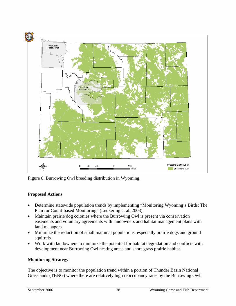
Figure 8. Burrowing Owl breeding distribution in Wyoming. Proposed Actions • Determine statewide population trends by implementing “Monitoring Wyoming’s Birds: The
Plan for Count-based Monitoring” (Leukering et al. 2003). • Maintain prairie dog colonies where the Burrowing Owl is present via conservation
easements and voluntary agreements with landowners and habitat management plans with land managers.
• Minimize the reduction of small mammal populations, especially prairie dogs and ground squirrels.
• Work with landowners to minimize the potential for habitat degradation and conflicts with development near Burrowing Owl nesting areas and short-grass prairie habitat.
Monitoring Strategy The objective is to monitor the population trend within a portion of Thunder Basin National Grasslands (TBNG) where there are relatively high reoccupancy rates by the Burrowing Owl.
September 2006 38 Wyoming Game and Fish Department
Point counts will be used to survey the Burrowing Owl. The following protocol is described in more detail in Conway et al. (2003). Surveys are conducted from a vehicle to maximize the area surveyed and prevent owls from flushing before being detected. Two observers conduct point-count surveys at 0.32-km intervals (0.2-mi intervals) along all roads and two-tracks in and around each prairie dog colony. Each survey begins at the edge of the colony where burrows are first observed. Point-count surveys consist of a 1-minute passive period followed by a 3-minute call-broadcast period. After the initial one-minute passive period, a speaker is placed on the car roof while surveyors listen and look for owls. The 3-minute call-broadcast segment consists of 30 seconds of calls followed by 30 seconds of silence, with this pattern repeated 3 times. The first two 30-second call periods consist of the primary male song (coo-coooo) of Burrowing Owls, and the final 30-second call period consists of an alarm call (quick-quick-quick). Observers scan the landscape using binoculars in a 360o arc around the survey station during the entire 4-minute survey. GPS coordinates, distance to the bird, and angle from the transect are recorded at the site of each observation. In addition, Department personnel will be encouraged to document Burrowing Owl sightings in the Wildlife Observation System, especially during late spring and early summer (breeding and young-rearing seasons). Researchers from the Arizona and Wyoming Cooperative Fish and Wildlife Research Units and the University of Wyoming are in the process of finalizing a four-year study of the Burrowing Owl in the TBNG region. In 2003, a total of 139 owls were observed and 76 owls were detected using standardized surveys (Conway et al. 2003). Implementation of monitoring by the WGFD depends upon the continuation of research projects by the Arizona and Wyoming Cooperative Fish and Wildlife Research Units and the availability of funding and field personnel.
September 2006 39 Wyoming Game and Fish Department
Ferruginous Hawk (Buteo regalis) Status The WGFD classifies the Ferruginous Hawk as a Native Species of Special Concern – NSS3 because the species is widely distributed, population status and trends are unknown but are suspected to be stable, and there is ongoing significant loss of habitat. The species is also sensitive to human disturbance. The BBS did not detect a trend for Ferruginous Hawks in Wyoming from 1966–2002. However, these data are considered uncertain because the BBS does not effectively monitor species, such as the Ferruginous Hawk, that occur at low densities, and because BBS estimates are much less accurate at fine geographic scales. Distribution The Ferruginous Hawk breeds from the Canadian Prairie Provinces south to Oregon, Nevada, Arizona, and Oklahoma (Bechard and Schmutz 1995). It winters from the central and southern portions of its breeding range south into Baja California and central Mexico. It occurs throughout most of Wyoming, and has been documented in all of the state’s 28 latilongs, with confirmed or probable breeding in 25 latilongs (Figure 9, Appendix C). Abundance The Ferruginous Hawk is considered a common summer resident in Wyoming. Habitat The Ferruginous Hawk inhabits semiarid open country, primarily grasslands, basin-prairie shrublands, and badlands. It requires large tracts of relatively undisturbed rangeland and nests on rock outcrops, the ground, cutbanks, cliff ledges, or trees (Bechard and Schmutz 1995). Problems • The Ferruginous Hawk is impacted by conversion of native prairie to cropland or other uses,
urbanization, human disturbance near nest sites, and reduced prey availability, including the elimination of prairie dog towns and ground squirrel colonies (Bechard and Schmutz 1995).
• Resource development is occurring or proposed for a significant portion of Ferruginous Hawk nesting habitat in Wyoming. Disturbance at the nest site can increase nest desertion and lower the productivity of nesting pairs (Bechard and Schmutz 1995).
• Current monitoring efforts such as the BBS are not adequate to document population trends or identify needed management over large areas of the state.
Proposed Actions • Continue to conduct aerial surveys in Ferruginous Hawk habitat to collect information on
nesting activity. • Work with private landowners to conserve grassland habitat by seeking financial incentives
from various sources and providing assistance and expertise with management activities.
September 2006 40 Wyoming Game and Fish Department
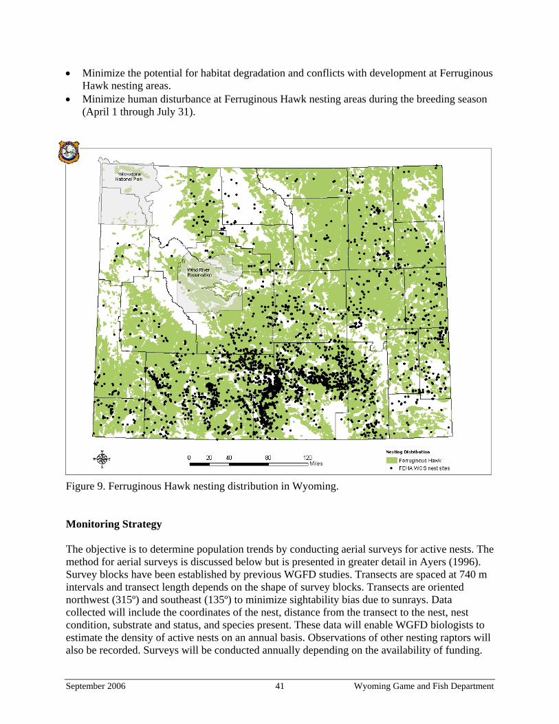
• Minimize the potential for habitat degradation and conflicts with development at Ferruginous Hawk nesting areas.
• Minimize human disturbance at Ferruginous Hawk nesting areas during the breeding season (April 1 through July 31).
Figure 9. Ferruginous Hawk nesting distribution in Wyoming. Monitoring Strategy The objective is to determine population trends by conducting aerial surveys for active nests. The method for aerial surveys is discussed below but is presented in greater detail in Ayers (1996). Survey blocks have been established by previous WGFD studies. Transects are spaced at 740 m intervals and transect length depends on the shape of survey blocks. Transects are oriented northwest (315º) and southeast (135º) to minimize sightability bias due to sunrays. Data collected will include the coordinates of the nest, distance from the transect to the nest, nest condition, substrate and status, and species present. These data will enable WGFD biologists to estimate the density of active nests on an annual basis. Observations of other nesting raptors will also be recorded. Surveys will be conducted annually depending on the availability of funding.
September 2006 41 Wyoming Game and Fish Department
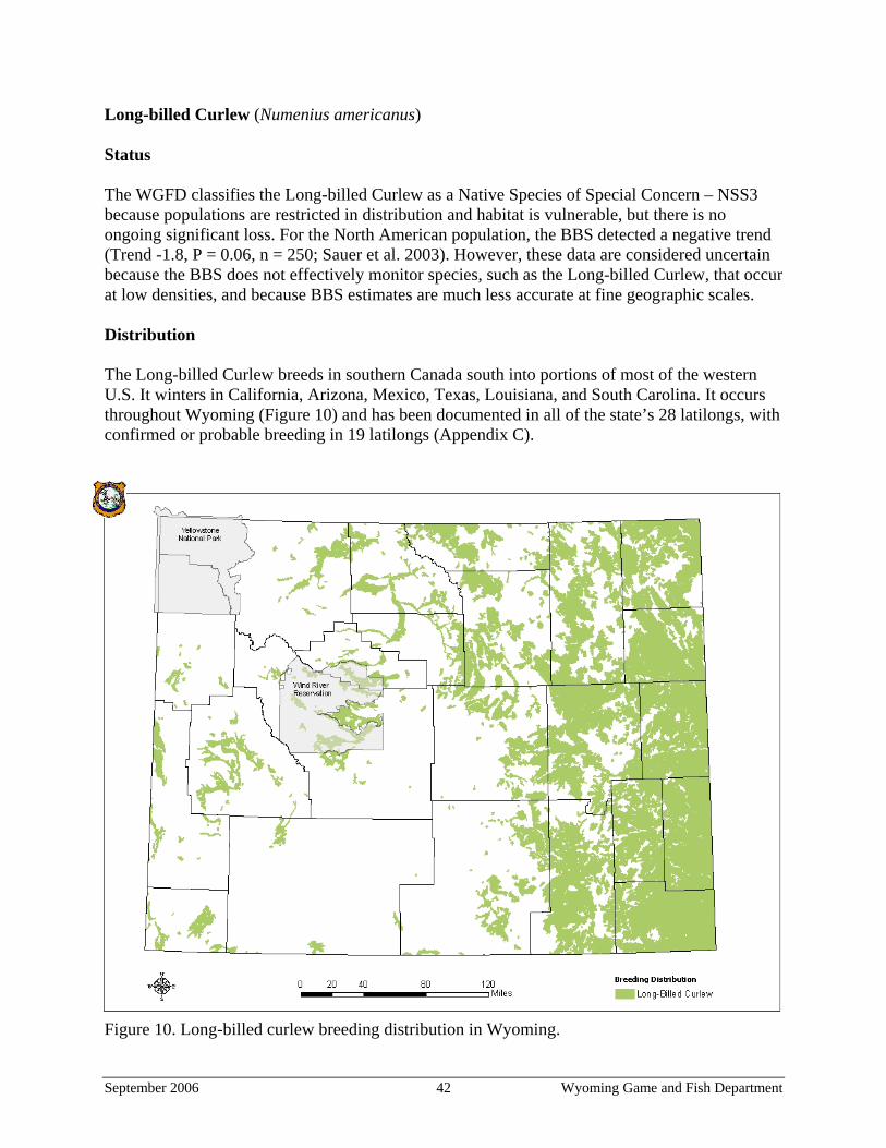
Long-billed Curlew (Numenius americanus) Status The WGFD classifies the Long-billed Curlew as a Native Species of Special Concern – NSS3 because populations are restricted in distribution and habitat is vulnerable, but there is no ongoing significant loss. For the North American population, the BBS detected a negative trend (Trend -1.8, P = 0.06, n = 250; Sauer et al. 2003). However, these data are considered uncertain because the BBS does not effectively monitor species, such as the Long-billed Curlew, that occur at low densities, and because BBS estimates are much less accurate at fine geographic scales. Distribution The Long-billed Curlew breeds in southern Canada south into portions of most of the western U.S. It winters in California, Arizona, Mexico, Texas, Louisiana, and South Carolina. It occurs throughout Wyoming (Figure 10) and has been documented in all of the state’s 28 latilongs, with confirmed or probable breeding in 19 latilongs (Appendix C).
Figure 10. Long-billed curlew breeding distribution in Wyoming.
September 2006 42 Wyoming Game and Fish Department
Abundance The Long-billed Curlew is considered an uncommon summer resident in Wyoming. Only those populations near Pinedale, Cody and Lusk can be considered locally common. Habitat The Long-billed Curlew inhabits a variety of grassland types ranging from moist meadow grasslands to agricultural areas to dry prairie uplands, usually near water. It prefers a complex of shortgrass prairies, agricultural fields, wet and dry meadows and prairies, and grazed mixed-grass and scrub communities. It nests on the ground in habitat that usually includes grass less than 30 cm (12 in) high, bare ground, shade, abundant invertebrate prey, and a minimum of 40 ha (100 ac) of suitable habitat. Problems • Uncontrolled hunting in the late 1800s and early 1900s, widespread conversion of native
prairie to agricultural fields up to the 1930s, and organochlorine pesticides have impacted Long-billed Curlew populations (Dugger and Dugger 2002).
• Habitat alteration or loss has occurred due to older plantings of crested wheatgrass (Agropyron cristatum) that create unnaturally dense and tall stands of vegetation, fire suppression that has allowed encroachment of trees and shrubs, and urban expansion.
• Population trends of Long-billed Curlews in eastern Wyoming are unknown. Additionally, curlew breeding habitat characteristics have not been evaluated and quantified in eastern Wyoming, precluding adequate monitoring and management.
• Curlew populations in Wyoming are not adequately sampled by existing BBS routes. Proposed Actions • Continue to conduct annual Long-billed Curlew surveys, in addition to the BBS, to determine
population trends. • Evaluate potential curlew habitat in eastern Wyoming to determine suitability, quantity,
location, land ownership, and land use and expand surveying efforts into these areas. • Develop and maintain a positive relationship with landowners on whose property Long-billed
Curlews nest. Educate landowners and encourage them to participate in promoting beneficial land use practices and management strategies for Long-billed Curlews on private land.
• Conserve grassland habitats by minimizing the conversion of native prairie to croplands, urban development and the spread of noxious and invasive plants through programs such as the Landowner Incentive Program and the Farm Bill.
• Encourage landowners to avoid potentially negative impacts to Long-billed Curlew nesting areas through the use of financial incentives.
• Use rotational burning, mowing and grazing as tools to create and maintain vegetative diversity and a mosaic of early and late successional stages and open ground within grasslands, meadows and prairies.
• Minimize conflicts with oil, gas, and recreational activities at Long-billed Curlew nesting areas during the breeding season (April through July).
September 2006 43 Wyoming Game and Fish Department
Monitoring Strategy The objective is to monitor the trend of the population near Hat Creek Breaks in Wyoming. A breeding population was identified there in 2004; Long-billed Curlews were detected at 8 of 20 points. Surveys begin 20 minutes before sunrise. An individual conducts surveys by making visual counts with binoculars every 0.8 km (0.5 mi) along a survey route. Two surveys will be conducted on separate days between April 21 and May 15. Results are reported as the number of curlews seen per kilometer of road surveyed. A more detailed description of survey methods is presented in Cerovski (2003). WGFD personnel will conduct these surveys on an annual basis.
September 2006 44 Wyoming Game and Fish Department
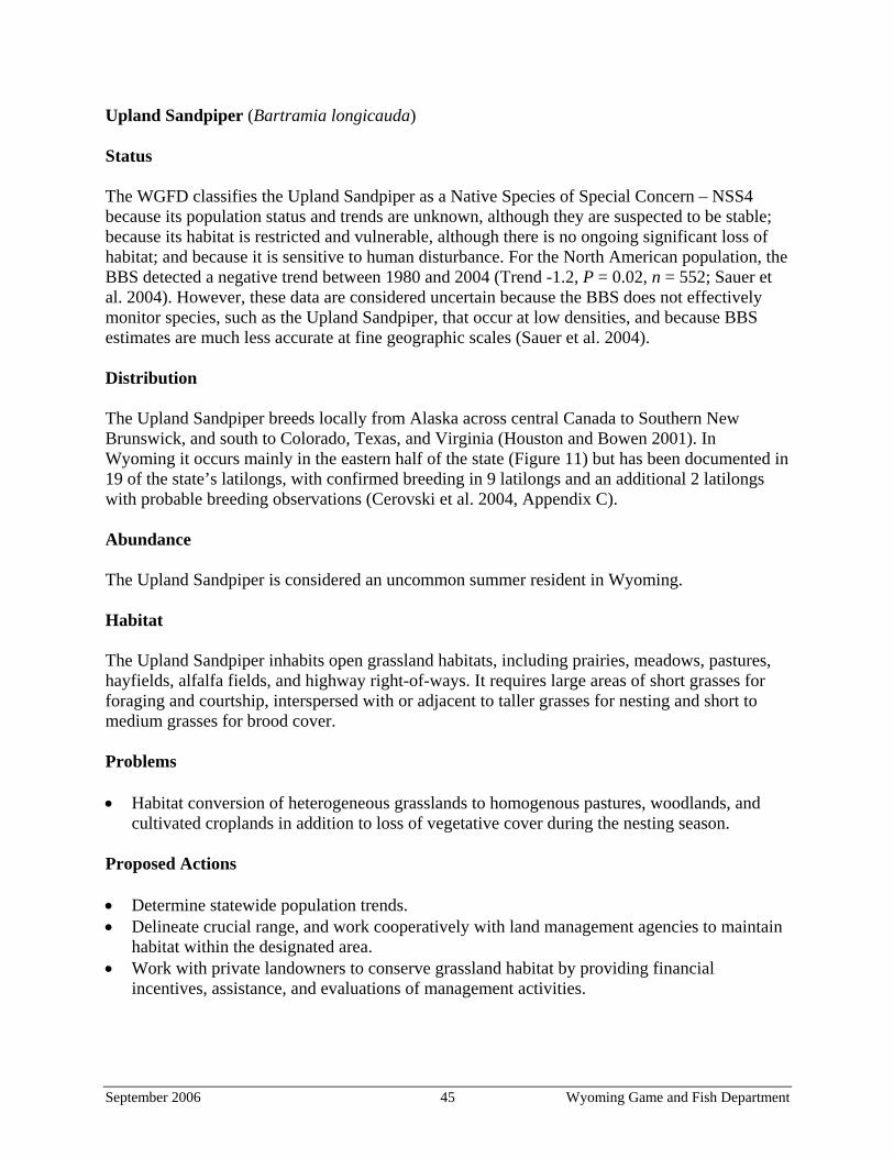
Upland Sandpiper (Bartramia longicauda) Status The WGFD classifies the Upland Sandpiper as a Native Species of Special Concern – NSS4 because its population status and trends are unknown, although they are suspected to be stable; because its habitat is restricted and vulnerable, although there is no ongoing significant loss of habitat; and because it is sensitive to human disturbance. For the North American population, the BBS detected a negative trend between 1980 and 2004 (Trend -1.2, P = 0.02, n = 552; Sauer et al. 2004). However, these data are considered uncertain because the BBS does not effectively monitor species, such as the Upland Sandpiper, that occur at low densities, and because BBS estimates are much less accurate at fine geographic scales (Sauer et al. 2004). Distribution The Upland Sandpiper breeds locally from Alaska across central Canada to Southern New Brunswick, and south to Colorado, Texas, and Virginia (Houston and Bowen 2001). In Wyoming it occurs mainly in the eastern half of the state (Figure 11) but has been documented in 19 of the state’s latilongs, with confirmed breeding in 9 latilongs and an additional 2 latilongs with probable breeding observations (Cerovski et al. 2004, Appendix C). Abundance The Upland Sandpiper is considered an uncommon summer resident in Wyoming. Habitat The Upland Sandpiper inhabits open grassland habitats, including prairies, meadows, pastures, hayfields, alfalfa fields, and highway right-of-ways. It requires large areas of short grasses for foraging and courtship, interspersed with or adjacent to taller grasses for nesting and short to medium grasses for brood cover. Problems • Habitat conversion of heterogeneous grasslands to homogenous pastures, woodlands, and
cultivated croplands in addition to loss of vegetative cover during the nesting season. Proposed Actions • Determine statewide population trends. • Delineate crucial range, and work cooperatively with land management agencies to maintain
habitat within the designated area. • Work with private landowners to conserve grassland habitat by providing financial
incentives, assistance, and evaluations of management activities.
September 2006 45 Wyoming Game and Fish Department
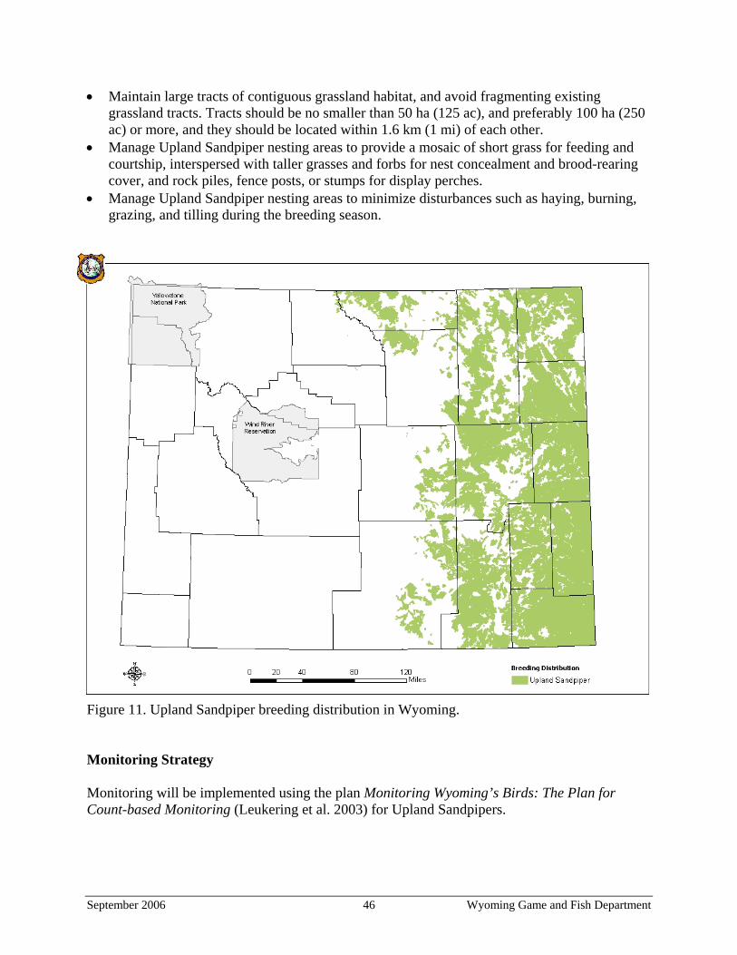
• Maintain large tracts of contiguous grassland habitat, and avoid fragmenting existing grassland tracts. Tracts should be no smaller than 50 ha (125 ac), and preferably 100 ha (250 ac) or more, and they should be located within 1.6 km (1 mi) of each other.
• Manage Upland Sandpiper nesting areas to provide a mosaic of short grass for feeding and courtship, interspersed with taller grasses and forbs for nest concealment and brood-rearing cover, and rock piles, fence posts, or stumps for display perches.
• Manage Upland Sandpiper nesting areas to minimize disturbances such as haying, burning, grazing, and tilling during the breeding season.
Figure 11. Upland Sandpiper breeding distribution in Wyoming. Monitoring Strategy Monitoring will be implemented using the plan Monitoring Wyoming’s Birds: The Plan for Count-based Monitoring (Leukering et al. 2003) for Upland Sandpipers.
September 2006 46 Wyoming Game and Fish Department
Other Grassland Birds Status Grassland birds are considered to be the fastest declining group of birds in North America (Nicholoff 2003). In addition to the bird species already discussed, Short-eared Owl (Asio flammeus) – NSS4; Baird’s Sparrow (Ammodramus bairdii); McCown’s Longspur (Calcarius mccownii) – NSS4; Lark Bunting (Calamospiza melanocorys) – NSS4; Grasshopper Sparrow (Ammodramus savannarum) – NSS4; Chestnut-collared Longspur (Calcarius ornatus) – NSS4; Dickcissel (Spiza americana) – NSS4; and Bobolink (Dolichonyx oryzivorus) – NSS4 are considered priorities for monitoring by Wyoming Partners In Flight (Nicholoff 2003). Distribution maps for each species are presented in Appendix C. The range-wide BBS trend estimate for each species is presented in Table 10. Problems Habitat loss is a primary threat to endemic birds of the grasslands. Causes of habitat loss include conversion for agriculture, urbanization, oil and gas development, fragmentation, reductions of native mammal populations, and suppression of natural disturbances. Increasing habitat loss from oil and gas development in Wyoming and the associated negative impacts of disturbance and fragmentation negatively affect birds (Ingelfinger 2001, Sedgewick 2004). For example, more than 12,000 CBNG wells already have been developed within the Powder River Basin, and it is forecasted that another 39,000 CBNG wells will be developed in the area over the next 10 years (BLM 2003). It is likely that the loss of natural disturbance has negatively affected grassland birds also. Humans have largely removed prairie dogs and bison from the grasslands. Prairie dogs have been eradicated from nearly 98 percent of the western Great Plains, and the estimated 30–60 million bison that used to roam the Great Plains are practically gone (Samson and Knopf 1996). Now, bison have been replaced by fenced cattle, which graze the landscape much more uniformly. Suppression of another natural disturbance, fire, has also decreased habitat quality. Many of these birds rely on habitat heterogeneity that previously occurred across the landscape but has decreased due to the removal of natural disturbances. Proposed Actions Grassland birds in Wyoming should benefit from increased habitat heterogeneity that simulates the influence of historical disturbances. Livestock grazing can be used to accomplish this. Livestock should be managed so that pastures reflect various grazing intensities ranging from light to heavy. Another tool that can simulate natural disturbance is prescribed burning. In order for these actions to be effective, they should occur at a broad scale whenever possible. Additionally, water improvements in the uplands and fence enclosures around riparian habitats could be effective tools for removing livestock from cottonwood riparian corridors and encouraging seedling survival.
September 2006 47 Wyoming Game and Fish Department

It is estimated that nearly 70% of the grasslands are privately owned. Therefore, the WGFD needs to build partnerships with private landowners to effectively conserve and manage habitat for the benefit of grassland birds. This can be done by using financial incentives (Farm Bill, Private Stewardship Grant Program, and Landowner Incentive Program), providing assistance/expertise with various management actions, and by establishing partnerships and pooling resources with organizations that have similar goals. Some of the organizations WGFD has already partnered with in bird conservation projects include the USFWS, USFS, RMBO, PP, TNC, IWJV, NGPJV, and the Audubon Society. The BBS was initiated in 1966 to obtain information on the trends of breeding birds throughout North America. At a broad geographic scale, BBS data provides the information necessary to detect continental trends in distribution and long-term changes in abundance. BBS results may be used as a guide to local or regional management decisions, with several caveats. BBS results are often inconclusive due to difficulties associated with the interpretation of index counts (Sauer 2000). Many species (especially less common species) and habitats are inadequately sampled, and BBS data do not reliably predict population trends at fine geographic scales (Sauer 2000). A goal of WGFD managers is to maintain the presence of these species within areas where BBS routes have detected them in the past. In 2002, RMBO initiated a monitoring program called Monitoring Wyoming’s Birds (Leukering et al. 2003) to address ways to determine population trends at the state scale. Transect locations were finalized in 2004, and data from that field season are now available. WGFD is a partner in this program. Management guidelines for these species are presented in Appendix C. Monitoring Strategy The objective is to monitor the distribution and population trends for the above-mentioned avian populations. To accomplish this, WGFD will continue to participate in the BBS and RMBO surveys. The BBS is sponsored jointly by the U.S. Geological Survey – Biological Resources Division and the Canadian Wildlife Service. Survey routes are 39.4 km (24.5 mi.) long and consist of 50 stops spaced 2.1 km (0.5 mi.) apart. Beginning at sunrise, observers record every bird seen and heard at each stop during a 3-minute period. BBS routes are located throughout Wyoming (U.S. Geological Survey 2001, Figure 12). RMBO oversees the Monitoring Wyoming’s Birds (Leukering et al. 2003) program. Thirty transects were randomly placed within the grasslands of eastern Wyoming (Figure 13). Point counts are conducted at 15 points along a 3.5 km (2 mi.) long transect (Table 11). At each point, species present are recorded during a 5-minute observation period (Doug Faulkner, Direct of Monitoring, RMBO, pers. comm.). More information on this survey is available at Leukering et al. (2003).
September 2006 48 Wyoming Game and Fish Department
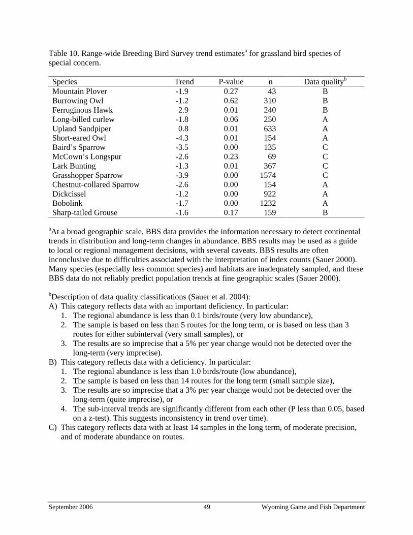
Table 10. Range-wide Breeding Bird Survey trend estimatesa for grassland bird species of special concern. Species Trend P-value n Data qualityb
Mountain Plover -1.9 0.27 43 B Burrowing Owl -1.2 0.62 310 B Ferruginous Hawk 2.9 0.01 240 B Long-billed curlew -1.8 0.06 250 A Upland Sandpiper 0.8 0.01 633 A Short-eared Owl -4.3 0.01 154 A Baird’s Sparrow -3.5 0.00 135 C McCown’s Longspur -2.6 0.23 69 C Lark Bunting -1.3 0.01 367 C Grasshopper Sparrow -3.9 0.00 1574 C Chestnut-collared Sparrow -2.6 0.00 154 A Dickcissel -1.2 0.00 922 A Bobolink -1.7 0.00 1232 A Sharp-tailed Grouse -1.6 0.17 159 B
aAt a broad geographic scale, BBS data provides the information necessary to detect continental trends in distribution and long-term changes in abundance. BBS results may be used as a guide to local or regional management decisions, with several caveats. BBS results are often inconclusive due to difficulties associated with the interpretation of index counts (Sauer 2000). Many species (especially less common species) and habitats are inadequately sampled, and these BBS data do not reliably predict population trends at fine geographic scales (Sauer 2000). bDescription of data quality classifications (Sauer et al. 2004): A) This category reflects data with an important deficiency. In particular:
1. The regional abundance is less than 0.1 birds/route (very low abundance), 2. The sample is based on less than 5 routes for the long term, or is based on less than 3
routes for either subinterval (very small samples), or 3. The results are so imprecise that a 5% per year change would not be detected over the
long-term (very imprecise). B) This category reflects data with a deficiency. In particular:
1. The regional abundance is less than 1.0 birds/route (low abundance), 2. The sample is based on less than 14 routes for the long term (small sample size), 3. The results are so imprecise that a 3% per year change would not be detected over the
long-term (quite imprecise), or 4. The sub-interval trends are significantly different from each other (P less than 0.05, based
on a z-test). This suggests inconsistency in trend over time). C) This category reflects data with at least 14 samples in the long term, of moderate precision,
and of moderate abundance on routes.
September 2006 49 Wyoming Game and Fish Department
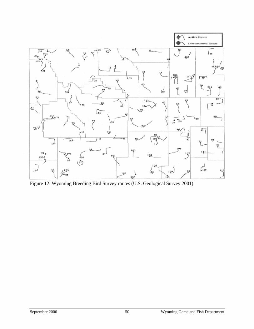
Figure 12. Wyoming Breeding Bird Survey routes (U.S. Geological Survey 2001).
September 2006 50 Wyoming Game and Fish Department
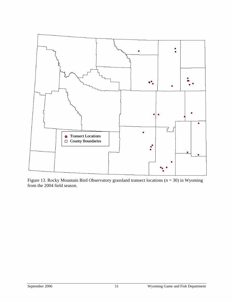
Figure 13. Rocky Mountain Bird Observatory grassland transect locations (n = 30) in Wyoming from the 2004 field season.
Transect LocationsCounty BoundariesTransect LocationsCounty Boundaries
September 2006 51 Wyoming Game and Fish Department
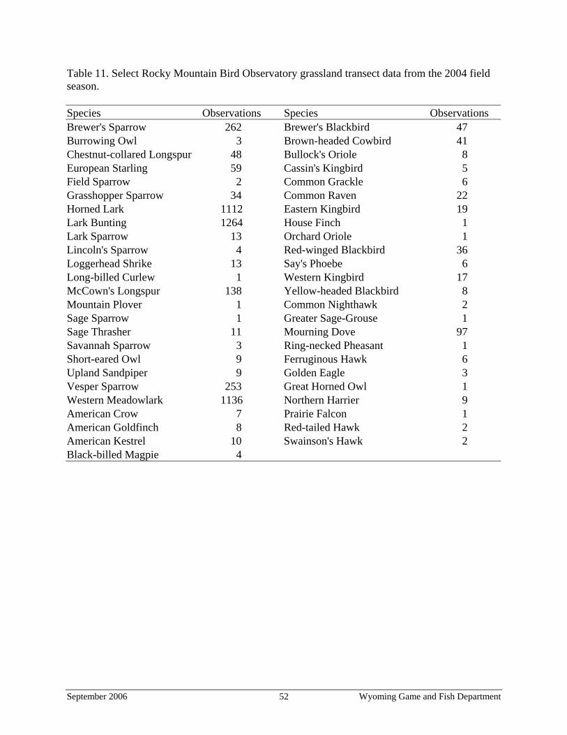
Table 11. Select Rocky Mountain Bird Observatory grassland transect data from the 2004 field season. Species Observations Species Observations Brewer's Sparrow 262 Brewer's Blackbird 47 Burrowing Owl 3 Brown-headed Cowbird 41 Chestnut-collared Longspur 48 Bullock's Oriole 8 European Starling 59 Cassin's Kingbird 5 Field Sparrow 2 Common Grackle 6 Grasshopper Sparrow 34 Common Raven 22 Horned Lark 1112 Eastern Kingbird 19 Lark Bunting 1264 House Finch 1 Lark Sparrow 13 Orchard Oriole 1 Lincoln's Sparrow 4 Red-winged Blackbird 36 Loggerhead Shrike 13 Say's Phoebe 6 Long-billed Curlew 1 Western Kingbird 17 McCown's Longspur 138 Yellow-headed Blackbird 8 Mountain Plover 1 Common Nighthawk 2 Sage Sparrow 1 Greater Sage-Grouse 1 Sage Thrasher 11 Mourning Dove 97 Savannah Sparrow 3 Ring-necked Pheasant 1 Short-eared Owl 9 Ferruginous Hawk 6 Upland Sandpiper 9 Golden Eagle 3 Vesper Sparrow 253 Great Horned Owl 1 Western Meadowlark 1136 Northern Harrier 9 American Crow 7 Prairie Falcon 1 American Goldfinch 8 Red-tailed Hawk 2 American Kestrel 10 Swainson's Hawk 2 Black-billed Magpie 4
September 2006 52 Wyoming Game and Fish Department
LITERATURE CITED Ayers, L. W. 1996. An aerial sightability model and reproductive parameters for nesting
Ferruginous Hawks (Buteo regalis) in southcentral Wyoming. Thesis, University of Wyoming, Laramie, Wyoming.
Bechard, M. J., and J. K. Schmutz. 1995. Ferruginous Hawk (Buteo regalis). In A. Poole, and F.
Gill, editors. The birds of North America, No. 172. The Birds of North America, Philadelphia, Pennsylvania.
Biggens, D. E., B. J. Miller, L. R. Hanebury, B. Oakleaf, A. H. Farmer, R. Creete, and A. Dood.
1993. A technique for evaluating black-footed ferret habitat. Pages 73–88 in J. L. Oldemeyer, D. E. Biggens, B. J. Miller, and R. Crete, editors. Proceedings of the symposium on the management of prairie dog complexes for the reintroduction of the black-footed ferret. Biological Report 13. U.S. Fish and Wildlife Service, Washington, D.C.
Campbell, P. 1997. Current population reports, population projections: States, 1995–2025. U.S.
Census Bureau, publication P25-1131, Washington, D.C. Online: <http://www.census. gov/prod/2/pop/p25/p25-1131.pdf>
Campbell, T. M., and T. W. Clark. 1981. Colony characteristics and vertebrate associates of
white-tailed and black-tailed prairie dogs in Wyoming. American Midland Naturalist 105:269–276.
Carbyn, L. N., H. J. Armbruster, and C. Mamo. 1994. The swift fox reintroduction program in
Canada from 1983 to 1992. Pages 247–271 in M. L. Bowles, and C. J. Whelan, editors. Restoration of endangered species: conceptual issues, planning and implementation. Cambridge University Press, New York, New York.
Cerovski, A. O. 2003. Long-billed Curlew surveys in western Wyoming. Pages 100–104 in A. O.
Cerovski, editor. Threatened, endangered, and nongame bird and mammal investigations: annual completion report. Wyoming Game and Fish Department, Cheyenne, Wyoming.
Cerovski, A. O., M. Grenier, B. Oakleaf, L. Van Fleet, and S. Palta. 2004. Atlas of birds,
mammals, amphibians, and reptiles in Wyoming. Wyoming Game and Fish Department, Nongame Program, Lander, Wyoming.
Clark, T. W., R. S. Hoffmann, and C. F. Nadler. 1971. Cynomys leucurus. Mammalian Species
No. 7. Comer, P., D. Faber-Langendoen, R. Evans, S. Gawler, C. Josse, G. Kittel, S. Menard, M. Pyne,
M. Reid, K. Schulz, K. Snow, and J. Teague. 2003. Ecological systems of the United States: a working classification of U.S. terrestrial systems. NatureServe, Arlington, Virginia.
September 2006 53 Wyoming Game and Fish Department
Conway, C. J., S. J. Lantz, and S. H. Anderson. 2003. Demographic consequences of habitat use for Burrowing Owls in northeast Wyoming, annual report for 2003. Unpublished report. Arizona Cooperative Fish and Wildlife Research Unit, Tucson, Arizona.
Copeland, H., J. Kiesecker, and J. Ward. 2005. Habitat quality and protection assessment of
Wyoming’s ecological systems. The Nature Conservancy, Wyoming Chapter, Lander Wyoming.
Covell, D. F. 1992. Ecology of the swift fox (Vulpes velox) in southeastern Colorado. Thesis,
University of Wisconsin, Madison, Wisconsin. Desmond, M. J., J. A. Savidge, and K. M. Eskridge. 2000. Correlations between Burrowing Owl
and black-tailed prairie dog declines: a 7-year analysis. Journal of Wildlife Management 64:1067–1075.
Dugger, B. D., and K. M. Dugger. 2002. Long-billed Curlew (Numenius americanus). In A.
Poole, and F. Gill, editors. The birds of North America, No. 628. The Birds of North America, Philadelphia, Pennsylvania.
Egoscue, H. J. 1979. Vulpes velox. Mammalian Species No. 122. Federal Register. 2004. Endangered and threatened wildlife and plants; 90-day finding on a
petition to list the white-tailed prairie dog as threatened or endangered. Federal Register 69:64889-64901.
Gori, D. F., and C. A. F. Enquist. 2003. An assessment of the spatial extent and condition of
grasslands in central and southern Arizona, southwestern New Mexico, and northern Mexico. The Nature Conservancy, Phoenix, Arizona.
Grenier, M. 2005. Nongame mammals – Chapter 20. Pages 20-1–20-11 in S. Tessman, editor.
Handbook of biological techniques. Wyoming Game and Fish Department, Cheyenne, Wyoming.
Grenier, M., B. Oakleaf, K. Taylor, and M. Hymas. 2004a. Inventory and mapping of black-
tailed prairie dogs in Wyoming - an estimate of acreage. Pages 114–133 in A. O. Cerovski, editor. Threatened, endangered, and nongame bird and mammal investigations: annual completion report. Wyoming Game and Fish Department, Cheyenne, Wyoming.
Grenier, M., B. Oakleaf, K. Taylor, and M. Hymas. 2004b. Inventory and monitoring of black-
tailed prairie dogs in Wyoming - status of colonies. Pages 94–113 in A. O. Cerovski, editor. Threatened, endangered, and nongame bird and mammal investigations: annual completion report. Wyoming Game and Fish Department, Cheyenne, Wyoming.
Grenier, M., L. Van Fleet, B. Oakleaf. 2004c. Spotlighting for free ranging black-footed ferrets
in the Shirley Basin/Medicine Bow Management Area, Wyoming. Pages 19–35 in A. O.
September 2006 54 Wyoming Game and Fish Department
Cerovski, editor. Threatened, endangered, and nongame bird and mammal investigations: annual completion report. Wyoming Game and Fish Department, Cheyenne, Wyoming.
Grenier, M., L. Van Fleet, R. Stephens, B. Oakleaf, T. Filipi, and D. Webber. 2005. Spotlighting
for free-ranging black-footed ferrets in the Shirley Basin/Medicine Bow Management Area, Wyoming. In press in A. O. Cerovski, editor. Threatened, endangered, and nongame bird and mammal investigations: annual completion report. Wyoming Game and Fish Department, Cheyenne, Wyoming.
Haug, E. A., B. A. Millsap, and M. S. Martell. 1993. Burrowing Owl (Speotyto cunicularia). In
A. Poole, and F. Gill, editors. The birds of North America, No. 61. The Birds of North America, Philadelphia, Pennsylvania.
Hoogland, J. L. 2003. Black-tailed prairie dog. Pages 232–247 in G. A. Feldhamer, B. C.
Thompson, and J. A. Chapman, editors. Wild mammals of North America: biology, management, and conservation. Second edition. Johns Hopkins University Press, Baltimore, Maryland.
Houston, C. S., and D. E. Bowen. 2001. Upland Sandpiper (Bartramia longicauda) In A. Poole,
and F. Gill, editors. The birds of North America, No. 580. The Birds of North America, Philadelphia, Pennsylvania.
Ingelfinger, F. M. 2001. The effects of natural gas development on sagebrush steppe passerines
in Sublette County, Wyoming. Thesis, University of Wyoming, Laramie, Wyoming. Kahn, R., L. Fox, P. Horner, B. Giddings, C. Roy, editors. 1997. Conservation assessment and
conservation strategy for swift fox in the United States. Colorado Division of Wildlife, Fort Collins, Colorado.
Klute, D. S., L. W. Ayers, M. T. Green, W. H. Howe, S. L. Jones, J. A. Shaffer, S. R. Sheffield,
and T. S. Zimmerman. 2003. Status assessment and conservation plan for the western Burrowing Owl in the United States. U.S. Fish and Wildlife Service, Biological Technical Publication FWS/BTP-R6001-2003, Washington, D.C.
Knapp, A. K., J. M. Blair, J. M. Briggs, S. L. Collins, D. C. Hartnett, L. C. Johnson, and E. G.
Towne. 1999. The keystone role of bison in North American tallgrass prairie: bison increase habitat heterogeneity and alter a broad array of plant, community, and ecosystem processes. Bioscience 49:39–50.
Knight, D. L. 1994. Mountains and plains, the ecology of Wyoming landscapes. Yale University
Press, New Haven, Connecticut. Knopf, F. L. 1996. Mountain Plover (Charadrius montanus). In A. Poole, and F. Gill, editors.
The birds of North America, No. 211. The Birds of North America, Philadelphia, Pennsylvania.
September 2006 55 Wyoming Game and Fish Department
Kotliar, N. B. 2000. Application of the new keystone-species concept to prairie dogs: how well does it work? Conservation Biology 14:1715–1721.
Kotliar, N. B., B. W. Baker, A. D. Whicker, and G. Plumb. 1999. A critical review of
assumptions about the prairie dog as a keystone species. Environmental Management 24:177–192.
Leukering T., M. F. Carter, A. Panjabi, D. Faulkner, and R. Levad. 2003. Monitoring
Wyoming’s birds: the plan for count-based monitoring. Pages 575–601 in S. H. Nicholoff, compiler. Wyoming bird conservation plan, Version 2.0. Wyoming Partners In Flight. Wyoming Game and Fish Department, Lander, Wyoming. Online: <http://www. blm.gov/wildlife/plan/WY/menu.htm>
Luce, B. 2003a. A multi-state conservation plan for the black-tailed prairie dog, Cynomys
ludovicianus, in the United States – an addendum to the black-tailed prairie dog conservation assessment and strategy, November 3, 1999. Prairie Dog Conservation Team, Sierra Vista, Arizona. Online: <http://www.wildlifemanagementinstitute.org/ images/P.dogsFINAL.pdf>
Luce, B. 2003b. Grassland wildlife species suggested conservation practices. High Plains
Partnership, U.S. Fish and Wildlife Service, Denver, Colorado. Online: <http://www.r6. fws.gov/endspp/hpp/Grassland%20Spp%20Conservation%20Prac_Final_Draft.pdf>
Lyman, R. M., and N. R. Jones. 2005. Wyoming minerals update: coal. October 2005. Wyoming
State Geological Survey, Laramie, Wyoming. Online: <http://www.wsgs.uwyo.edu/ Mineral_Updates/Oct2005/MU_Coal_Oct2005.pdf>
Matlack, R. S., P. S. Gipson, and D. W. Kaufman. 2000. The swift fox in rangeland and cropland
in western Kansas: relative abundance, mortality, and body size. The Southwestern Naturalist 45:221–225.
Merrill, E. H., T. W. Kohley, M. E. Herdendorf, W. A. Reiners, K. L. Driese, R. W. Marrs, and
S. H. Anderson. 1996. The Wyoming gap analysis project final report. Department of Zoology and Physiology, Department of Botany, and Wyoming Cooperative Fish and Wildlife Research Unit, University of Wyoming, Laramie, Wyoming.
Miller, S. D., and J. F. Cully, Jr. 2001. Conservation of black-tailed prairie dogs (Cynomys
ludovicianus). Journal of Mammalogy 82:889–893. Nicholoff, S. H., compiler. 2003. Wyoming bird conservation plan. Version 2.0. Wyoming
Partners In Flight. Wyoming Game and Fish Department, Lander, Wyoming. Online: <http://www.blm.gov/wildlife/plan/WY/menu.htm>
Oakleaf, B., A. O. Cerovski, and B. Luce. 1996. Nongame bird and mammal plan: a plan for
inventories and management of nongame birds and mammals in Wyoming. Wyoming Game and Fish Department, Nongame Program, Lander, Wyoming.
September 2006 56 Wyoming Game and Fish Department
Olson, T. L. and F. G. Lindzey. 2002. Swift fox survival and production in southeastern Wyoming. Journal of Mammalogy 83:199–206.
Plumb, R. E. 2004. Minimum population size and concentration areas of mountain plovers
breeding in Wyoming. Thesis, University of Wyoming, Laramie, Wyoming. Ricklefs, R. E., editor. 1993. The economy of nature. Third edition. W.H. Freeman and Co., New
York, New York. Samson, F. B. and F. L. Knopf. 1996. Prairie conservation: preserving North America’s most
endangered ecosystem. Island Press, Washington, D.C. Samson, F. B., F. L. Knopf, and W. R. Ostlie. 1998. Grasslands. Pages 437-472 in M. J. Mac, P.
A. Opler, C. E. Puckett Haecker, and P. D. Doran, editors. Status and Trends of the Nation's Biological Resources, Volume Two. Northern Prairie Wildlife Research Center, Jamestown, North Dakota. Online: <http://www.npwrc.usgs.gov/resource/2000/grlands/ grlands.htm>
Sauer, J. R. 2000. Combining information from monitoring programs: complications associated
with indices and geographic scale. In R. Bonny, D. N. Pashley, R. J. Cooper, and L. Niles, editors. Strategies for bird conservation: The Partners in Flight planning process. Proceedings from the third Partners in Flight workshop; 1995 Oct 1–5, Cape May, New Jersey. Proceedings RMRS-P-16. U.S. Department of Agriculture, Forest Service, Rocky Mountain Research Station, Ogden, Utah. Online: <http://birds.cornell.edu/pifcapemay>
Sauer, J. R., J. E. Hines, and J. Fallon. 2003. The North American breeding bird survey, results
and analysis 1966–2002. Version 2003.1, USGS Patuxent Wildlife Research Center, Laurel, Maryland.
Sauer, J. R., J. E. Hines, and J. Fallon. 2004. The North American breeding bird survey, results
and analysis 1966–2003. Version 2004.1. USGS Patuxent Wildlife Research Center, Laurel, Maryland.
Sedgewick, J. A. 2004. McCown’s Longspur (Calcarius mccownii): a technical conservation
assessment. U.S. Forest Service, Rocky Mountain Region, Golden, Colorado. Online: <http://www.fs.fed.us/r2/projects/scp/assessments/mccownslongspur.pdf>
Seglund, A.E., A.E. Ernst, M. Grenier, B. Luce, A. Puchniak and P. Schnurr. 2004. White-tailed
prairie dog conservation assessment. Prairie Dog Conservation Team, Sierra Vista, Arizona. Online: <http://www.nativeecosystems.org/prairiedogs/whitetailed/ WTPDCAFINAL0804.pdf>
[SB/MB-BFWG] Shirley Basin/Medicine Bow Black-footed Ferret Working Group. 1991. A
cooperative management plan for black-footed ferrets, Shirley Basin/Medicine Bow, Wyoming. Wyoming Game and Fish Department, Cheyenne, Wyoming.
September 2006 57 Wyoming Game and Fish Department
Sovada, M. A., C. C. Roy, J. B. Bright, and J. R. Gillis. 1998. Causes and rates of mortality of swift foxes in western Kansas. Journal of Wildlife Management 62:1300–1306.
Stephens, R. M. 2005. Mountain Plover monitoring at five concentration areas in Wyoming. In
press in A. O. Cerovski, editor. Threatened, endangered, and nongame bird and mammal investigations: annual completion report. Wyoming Game and Fish Department, Cheyenne, Wyoming.
Thorne, E. T., and B. Oakleaf. 1991. Species rescue for captive breeding: black-footed ferret as
an example. Pages 241–261 in J. H. W. Gibbs, editor. Beyond captive breedings, reintroducing endangered mammals to the wild. Clarendon Press, Oxford, United Kingdom.
[BLM] U.S. Bureau of Land Management. 2003. The record of decision and resource
management plan amendments for the Powder River Basin oil and gas project of land management. U.S. Bureau of Land Management, Buffalo, Wyoming.
[USCB] U.S. Census Bureau. 2006. State and county quick facts. U.S. Census Bureau,
Washington, D.C. Online: <http://quickfacts.census.gov/qfd/states/56000.html> [USDA] U.S. Department of Agriculture. 2000. Summary report: 1997 National Resources
Inventory (revised December 2000). Natural Resources Conservation Service, Washington, D.C., and Statistical Laboratory, Iowa State University, Ames, Iowa. Online: <http://www.nrcs.usda.gov/technical/nri/1997/summary_report/>
[USFWS] U.S. Fish and Wildlife Service. 2002. Mountain Plover survey guidelines - Montana.
U.S. Fish and Wildlife Service, Montana Field Office, Helena, Montana. Online: <http:// montanafieldoffice.fws.gov/Endangered_Species/Survey_Guidelines/Mountain_Plover_Survey_Guidelines.pdf>
[USGS] U.S. Geological Survey. 2001. Wyoming breeding bird survey route locations. U.S.
Geological Survey, Patuxent Wildlife Research Center, Laurel, Maryland. Online: <http://www.pwrc.usgs.gov/BBS/results/routemaps/wyoming.htm>
Wright, H. A., and A. W. Bailey. 1980. Fire ecology and prescribed burning in the Great Plains:
A research review. U.S. Forest Service, General Technical Report. INT-77, Washington D.C.
[WYDAI] Wyoming Department of Administration and Information. 2001. Historical decennial
census population for Wyoming counties, cities, and towns. Wyoming Department of Administration and Information, Division of Economic Analysis, Cheyenne, Wyoming. Online: <http://eadiv.state.wy.us/demog_data/cntycity_hist.htm>
[WGFD] Wyoming Game and Fish Department. 1987. A strategic plan for the management of
black-footed ferrets in Wyoming. Wyoming Game and Fish Department, Cheyenne, Wyoming.
September 2006 58 Wyoming Game and Fish Department
[WGFD] Wyoming Game and Fish Department. 2004. Recommendations for development of oil and gas resources within crucial and important wildlife habitats. Wyoming Game and Fish Department, Cheyenne, Wyoming. Online: <http://gf.state.wy.us/downloads/pdf/ og.pdf>
[WGFD] Wyoming Game and Fish Department. 2005. A comprehensive wildlife conservation
strategy for Wyoming. Wyoming Game and Fish Department, Cheyenne, Wyoming. Online: <http://gf.state.wy.us/wildlife/CompConvStrategy/index.asp>
Wyoming Mining Association. 2004. A concise guide to Wyoming coal. Wyoming Coal
Information Committee, Wyoming Mining Association, Cheyenne, Wyoming. Online: <http://www.wma-minelife.com/coal/CONG2004/Concise%20Guide%202004B.pdf>
Wyoming Partners In Flight. 2002. Growing grassland birds: best management practice for
grasslands to benefit birds in Wyoming. Wyoming Game and Fish Department, Lander, Wyoming. Online: <http://gf.state.wy.us/wildlife/nongame/BestManagementPractices/ GrowingGrasslandBirds.pdf>
Wyoming State Legislature. 2005. Wyoming Weed and Pest Control Act of 1973. Wyoming
State Statute Title Eleven, Chapter Five. Wyoming State Legislature, Cheyenne, Wyoming. Online: <http://legisweb.state.wy.us/statutes/titles/title11/chapter05.htm>
September 2006 59 Wyoming Game and Fish Department
Appendix A. Existing management plans and conservation strategies for grassland wildlife. [BFAT] Black-footed Ferret Advisory Team. 1990. A cooperative management plan for
black-footed ferrets at Meeteetse. Wyoming Game and Fish Department, Cheyenne, Wyoming.
Colorado Division of Wildlife. 2003. Conservation plan for grassland species in Colorado.
Colorado Division of Wildlife, Denver, Colorado. Online: <http://wildlife.state.co.us/ LandWater/Grasslands/>
Dechant, J. A., M. L. Sondreal, D. H. Johnson, L. D. Igl, C.M. Goldade, M.P. Nenneman, and
B.R. Euliss. 2003a. Effects of management practices on grassland birds: Mountain Plover. Northern Prairie Wildlife Research Center, Jamestown, North Dakota. Online: <http://www.npwrc.usgs.gov/resource/literatr/grasbird/mopl/mopl.htm>
Dechant, J. A., M. L. Sondreal, D. H. Johnson, L. D. Igl, C. M. Goldade, P. A. Rabie, and B. R.
Euliss. 2003b. Effects of management practices on grassland birds: Long-billed Curlew. Northern Prairie Wildlife Research Center, Jamestown, North Dakota. Online: <http:// www.npwrc.usgs.gov/resource/literatr/grasbird/lbcu/lbcu.htm>
Dinsmore, S. J. 2003. Mountain Plover (Charadrius montanus): a technical conservation
assessment. USDA Forest Service, Rocky Mountain Region, Golden, Colorado. Online: <http://www.fs.fed.us/r2/projects/scp/assessments/mountainplover.pdf>
Kahn, R., L. Fox, P. Horner, B. Giddings, C. Roy, editors. 1997. Conservation assessment and
conservation strategy for swift fox in the United States. Colorado Division of Wildlife, Denver, Colorado. Online: <http://wildlife.state.co.us/NR/rdonlyres/7DFD8BFD-FBD7-41BD-AA84-45FB8BD94499/0/Kahnetal1997SwiftFoxConservation.pdf>
Klute, D. S., L. W. Ayers, M. T. Green, W. H. Howe, S. L. Jones, J. A. Shaffer, S. R. Sheffield,
and T. S. Zimmerman. 2003. Status assessment and conservation plan for the western Burrowing Owl in the United States. U.S. Fish and Wildlife Service, Biological Technical Publication FWS/BTP-R6001-2003, Washington, D.C. Online: <http:// mountain-prairie.fws.gov/birds/WBO/Western%20Burrowing%20Owlrev73003a.pdf>
Leukering T., M. F. Carter, A. Panjabi, D. Faulkner, and R. Levad. 2003. Monitoring
Wyoming’s birds: the plan for count-based monitoring. Pages 575–601 in S. H. Nicholoff, compiler. Wyoming bird conservation plan, Version 2.0. Wyoming Partners In Flight. Wyoming Game and Fish Department, Lander, Wyoming. Online: <http://www. blm.gov/wildlife/plan/WY/menu.htm>
Luce, B. 2003a. A multi-state conservation plan for the black-tailed prairie dog, Cynomys
ludovicianus, in the United States – an addendum to the black-tailed prairie dog conservation assessment and strategy, November 3, 1999. Prairie Dog Conservation
September 2006 60 Wyoming Game and Fish Department
Team, Sierra Vista, Arizona. Online: <http://www.wildlifemanagementinstitute.org/ images/P.dogsFINAL.pdf>
Luce, B. 2003b. Grassland wildlife species suggested conservation practices. High Plains
Partnership, U.S. Fish and Wildlife Service, Denver, Colorado. Online: <http://www.r6. fws.gov/endspp/hpp/Grassland%20Spp%20Conservation%20Prac_Final_Draft.pdf>
Nicholoff, S. H., compiler. 2003. Wyoming bird conservation plan, Version 2.0. Wyoming
Partners In Flight. Wyoming Game and Fish Department, Lander, Wyoming. Online: <http://www.blm.gov/wildlife/plan/WY/menu.htm>
Oakleaf, B., A. O. Cerovski, and B. Luce. 1996. Nongame bird and mammal plan. Wyoming
Game and Fish Department, Lander, Wyoming. Online: <http://gf.state.wy.us/wildlife/ nongame/NongamePlan/index.asp>
Van Pelt, W. E. 1999. The black-tailed prairie dog conservation assessment and strategy.
Arizona Game and Fish Department, Phoenix, Arizona. Wyoming Game and Fish Department. 1987. A strategic plan for the management of black-
footed ferrets in Wyoming. Wyoming Game and Fish Department, Cheyenne, Wyoming. Wyoming Game and Fish Department. 1991. Black-footed ferret reintroduction – Shirley Basin,
Wyoming. Wyoming Game and Fish Department, Cheyenne, Wyoming. Wyoming Partners In Flight. 2002. Growing grassland birds: best management practice for
grasslands to benefit birds in Wyoming. Wyoming Game and Fish Department, Lander, Wyoming. Online: <http://gf.state.wy.us/wildlife/nongame/BestManagementPractices/GrowingGrasslandBirds.pdf>
September 2006 61 Wyoming Game and Fish Department
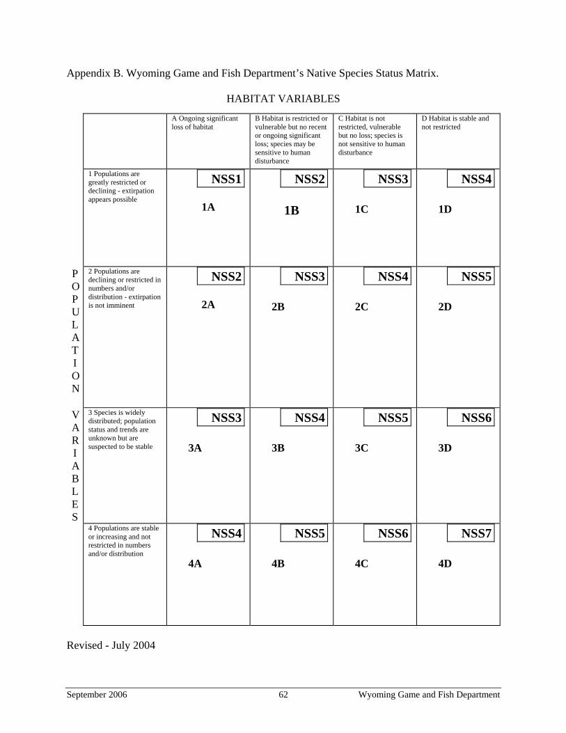
Appendix B. Wyoming Game and Fish Department’s Native Species Status Matrix.
HABITAT VARIABLES
A Ongoing significant loss of habitat
B Habitat is restricted or vulnerable but no recent or ongoing significant loss; species may be sensitive to human disturbance
C Habitat is not restricted, vulnerable but no loss; species is not sensitive to human disturbance
D Habitat is stable and not restricted
1 Populations are greatly restricted or declining - extirpation appears possible
NSS1
1A
NSS2
1B
NSS3
1C
NSS4
1D
P O P U L A T I O N
2 Populations are declining or restricted in numbers and/or distribution - extirpation is not imminent
NSS2
2A
NSS3
2B
NSS4
2C
NSS5
2D
V A R I A B L E S
3 Species is widely distributed; population status and trends are unknown but are suspected to be stable
NSS3
3A
NSS4
3B
NSS5
3C
NSS6
3D
4 Populations are stable or increasing and not restricted in numbers and/or distribution
NSS4
4A
NSS5
4B
NSS6 NSS7
4C 4D
Revised - July 2004
September 2006 62 Wyoming Game and Fish Department
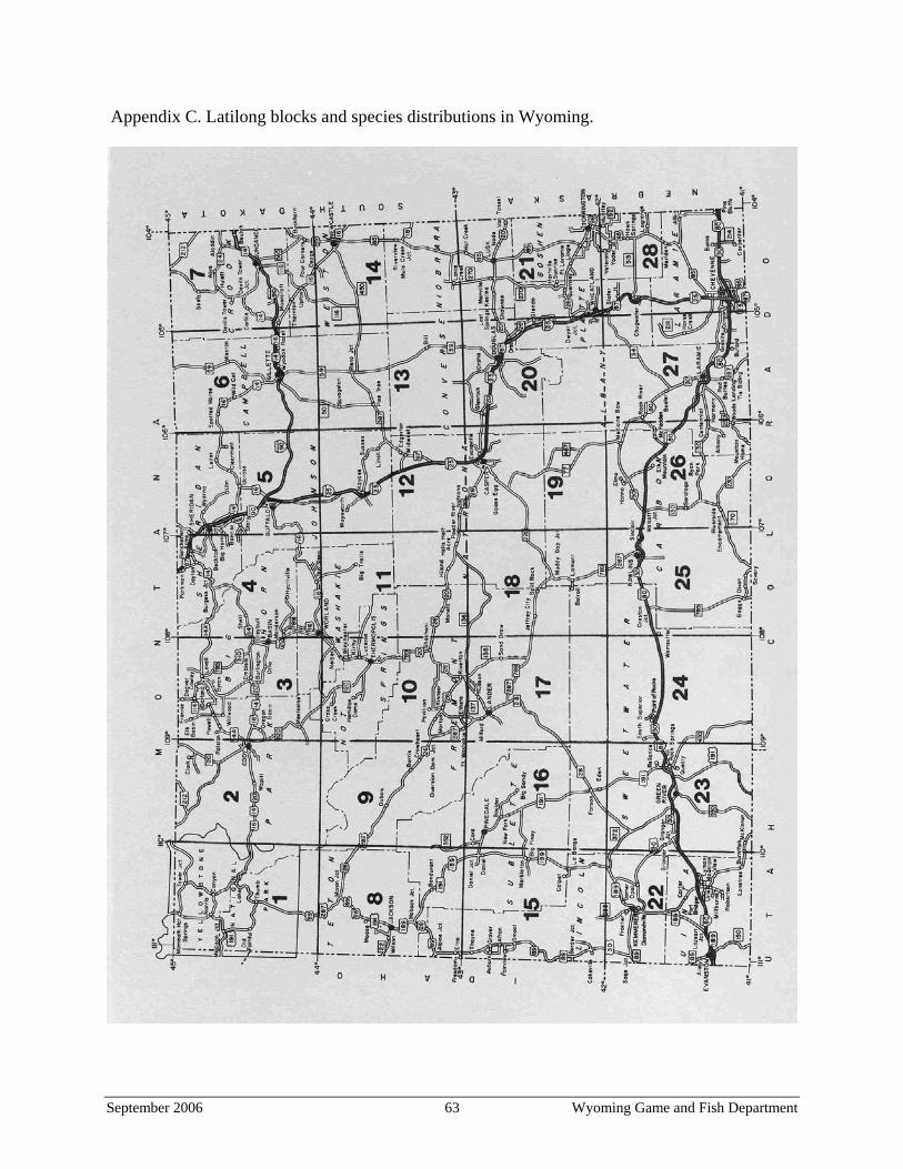
Appendix C. Latilong blocks and species distributions in Wyoming.
September 2006 63 Wyoming Game and Fish Department

Note: The grids under each species in the following sections correspond to the Latilong figure on page 63 (For example, the blank in the upper left of each grid corresponds to Latilong #1). Mammals B Nest, dependent young, juvenile animals, lactating or post-lactation females, or males in
breeding condition were observed. b Animals were observed and, due to limited mobility, breeding is assumed (bats and large
ungulates are highly mobile and are not automatically placed in this category). O The species has been observed but, due to the mobility of the species’ group and lack of
factors listed under (B), breeding cannot be assumed (applies to bats and large ungulates). H Historical breeding record, prior to 1965. No recent data to indicate the species still breeds
or occurs in that latilong. h Historical record of occurrence before 1965. No recent data to suggest occurrence. _ No verified records.
White-tailed prairie dog Black-tailed prairie dog
_ B B h _ _ _ _ h B B B B B_ B B B B B B _ _ _ B B B BB B B B B B B _ _ _ _ B B BB B B B B B _ _ _ _ _ _ _ B
Swift fox Black-footed ferret _ _ _ b _ b b _ O O O h O h_ _ _ _ b b B _ O O O O h h_ _ O _ B b B O O O O B h HO b _ h b B B h O h h h h H Olive-backed pocket mouse Hispid pocket mouse _ B B _ b B b _ _ _ _ _ _ b_ _ h b B B B _ _ _ _ _ _ _h _ _ B B B h _ _ _ _ _ _ b_ B B B B B B _ _ _ _ _ h B
Plains harvest mouse Plains pocket gopher _ _ _ _ _ h b _ _ _ _ b _ __ _ _ _ _ _ B _ _ _ _ _ _ __ _ _ _ _ _ B _ _ _ _ b _ B_ _ _ _ _ B B _ _ _ _ _ B B
September 2006 64 Wyoming Game and Fish Department

Plains pocket mouse Prairie vole _ _ _ _ b _ _ _ _ B B B B B_ _ _ _ _ _ _ h _ b b b B B_ _ _ _ b _ B _ _ B _ B B B_ _ _ _ _ B B _ _ _ _ b B B
Birds B Nest or young dependent upon parent birds was observed. b Circumstantial evidence of nesting. O The species has been observed, but there was no evidence of nesting. The observation may
have been recorded during any season of the year, but observations are most likely to correspond with seasonal status listed in Table 1 of Cerovski et al. (2004).
H Historical nesting record, prior to 1950. No recent data to indicate the species still nests or occurs in that latilong.
h Historical record with no indication of nesting. _ No verified records.
Burrowing Owl Ferruginous Hawk O B B B B B O O B B B B B BB O B O B B B b O O B B B BB B B B B B B B B B B B B BB B B B B B B B B B B B B B
Mountain Plover Long-billed Curlew O B B B O O O B B B B b B OO O B B O B O B B b O O O OB b B B B B B B b B b B O Bb B b B B B B B B b O B O O
Upland Sandpiper Short-eared Owl O O O B B B B B O O B B B OO _ O _ _ B B B O B O O B b_ _ _ B b O B B b O O B O O_ b _ _ O O B b B b B O B O
September 2006 65 Wyoming Game and Fish Department

Chestnut-collared Longspur Dickcissel _ O O O O B O _ O O O B O BO O O _ _ b O O _ O _ _ O O_ _ _ _ O O b _ _ O O O O B_ _ O _ O b B _ O _ _ O O O
Baird’s Sparrow McCown’s Longspur _ _ _ O O _ O O B b O b B O_ O O O _ b _ O _ O B b B O_ _ _ _ O _ O _ O O B B b B_ _ _ _ _ b b _ O O B b B B
Lark Bunting Grasshopper Sparrow O b B B B B B O O O b b B BO B B b B B B O O B _ b B bO B B b B B B b b _ O B b Ob b B B b B B b b _ _ _ O b
Bobolink O B B B O b B O b O O O b O B O O O O O b O b O O b
September 2006 66 Wyoming Game and Fish Department