y' 0 s rn - smithsonian institutioninvertebrates.si.edu/boem/reports/sofla_execsum.pdfare often...
TRANSCRIPT

C
m K d
O
.
d ~
oto
N~ ln0 G
1
Ol"MM
1 i
i s
r i
8 a
s r
o ..
~ -
=Q
w
:4s
t ~i
:'+r7~`'
'~ ~° s
..i f'+ .
'
" 1�
~3
T'.~ e
~s ~
. .
s
~
o "
-- ~ -_
-----
to
t
------------------
-
1011
1 !"
w
------------------------
S z --
- --
--
o rn Cl
) 0 0
C .. rn-
Y' O
W
C) CL
C
.
r. 0
v ̂
'

This report has been technically reviewed according to contractual specifications . It, however, is exempt from review by the Minerals Management Service Publications Unit and the Regional Editor.

OCS Study MMS 87-0022
Southwest Florida Shelf Ecosystems Study
Volume I : Executive Summary
Authors
Environmental Science and Engineering, Inc . Gainesville, Florida
LGL Ecological Research Associates, Inc . Bryan, Texas
Continental Shelf Associates, Inc . Tequesta, Florida
Prepared under MMS Contract 14-12-0001-30276
Published by
U.S. Department of the Interior Minerals Management Service New Orleans Gulf of Mexico OCS Regional Office June 1987

DISCLAIMER
This data synthesis report has been reviewed by the Minerals Management Service and approved for publication . Approval does riot signify that contents necessarily reflect the views and policies o$ the Service, nor does mention of trade names or commercial products constitute endorsement or recommendations for use .
REPORT AVAILABILITY
This data synthesis report was prepared under contract between the Minerals Management Service and Environmental Science and Engineering, Inc . Extra copies may be obtained from the Public Information Section (Mail Stop OPS-3--4) at the following address :
Minerals Management Service Gulf of Mexico OCS Regional Office U .S . Department of the Interior 1201 Elmwood Park Boulevard New Orleans, Louisiana 70123-2394 ATTN : Public Information Section Telephone : (504) 736-0557
CITATION
This volume should be cited as :
Environmental Science and Engineering, Inc ., LGL Ecological Research Associates, Inc ., and Continental Shelf Associates, Inc . 1987 . Southwest Florida Shelf Ecosystems Study Data Synthesis Report . Submitted under Contract No . 14-12-0001-30276 to the Minerals Management Service, New Orleans, Louisiana . 3 vol .

TABLE OF CONTENTS VOLUME I--EXECUTIVE SUMMARY
Section Pee
1 .0 INTRODUCTION 1
2 .0 CHARACTERIZATION OF STUDY AREA 6
2 .1 PHYSIOGRAPHY, GEOLOGY, AND SEDIMENTOLOGY 6 2 .2 METEOROLOGY AND PHYSICAL OCEANOGRAPHY 14 2 .3 HYDROGRAPHY, CHEMICAL OCEANOGRAPHY,
AND HYDROCARBONS 23 2 .4 INFAUNA AND SESSILE EPIFAUNA 31 2 .5~ MOTILE EPIFAUNA AND FISHES 37 2 .6 FISHERIES/SOCIOECONOMICS 41 2 .7 ENDANGERED SPECIES AND AREAS OF
SPECIAL CONCERN 44
3 .0 POTENTIAL OIL AND GAS DEVELOPMENT IMPACT PROJECTIONS 47
4 .0 LITERATURE CITED 63
i

LIST OF TABLES
Table Paee
2-1 List of most abundant~infaunal species . 32
3-1 Factor train analysis of potential impacts of related activities on habitats of the continental shelf of southwest Florida . 49
3-2 Potential impacts of oil- and gas-related activities on ecosystems of the southwest Florida continental shelf . 70
ii

LIST OF FIGURES Figure Paee
1-1 Southwest Florida Shelf Ecosystems Program study area with Years 1 through 5 geophysical and towed underwater television transects and discrete stations indicated .
2-1 Locations of major reef features and geologic cross section on the southwest Florida shelf .
2-2 Southwest Florida shelf sediment texture and calcium carbonate content .
2-3 Substratum types and distribution along study transects .
2-4 Example of the change in current velocity characteristics from elliptical to rectilinear motion and diurnal to semidiurnal periodicity as depth decreases from 32 m (Station 7) to 13 m (Station 52)
2-5 Estimated annual residual current pattern based upon Eulerian current data collected by ESE and LGL (1986) and SAIC (1986) as well as historical Lagrangian current data .
2-6
2-7
2-8
2-9
2-10
2-11
Schematic representation of Loop Current features and dynamic processes and a cross section through a warm filament showing distribution of temperature .
The effects of Loop Current intrusions and boundary perturbations on current velocity and temperature .
The effect of the passage of Tropical Storm Bob on current velocity and temperature during July 1985
Surface sediment sample stations and hydrocarbon source characteristic distribution .
Station groupings from normal classification analysis of infaunal data .
3
7
10
13
19
21
22
214
29
33
Biotic zonation of the southwest Florida continental shelf (northern transect) showing general distribution patterns of major components of the flora and fauna . 34
iii

0
LIST OF FIGURES (Continued, Page 2 of 2)
ure - pace
2-12 Biotic zonation of the southwest Florida continental shelf (southern transect) showing general distribution of major components of the flora and fauna . 35
2-13 Commercial finfish and shellfish landings in millions of pounds and millions of dollars by county . 43
2-14 Locations of environmentally sens itive coastal habitats in southwest Florida . 46
3-1 Example of conceptual submodel of potential impacts of oil- and gas-related activities on a valued ecosystem component (snappers and groupers) . 53
3-2 Matrix summary of potential impacts of oil- and gas- - -related activities on valued ecosystem components . 55
iv
1 .0 INTRODUCTION
The Minerals Management Service (MMS) has four priority goals for outer
continental shelf (OCS) leasing : (1) orderly resource development to
meet the nation's energy needs ; (2) protection of the human, marine, and coastal environments ; (3) receipt of fair market value ; and (4)
preservation of free enterprise competition . =nformed management
decision making is paramount in achieving these goals . The MMS OCS
Environmental Studies Program is one of the instruments used by MMS to
aid in the decision making process . The objectives of this program are
to obtain environmental data on the impacts of petroleum exploration and
production activities on the OCS and provide relevant information to
support management decisions concerning OCS leasing .
This report concludes the 6-year Southwest Florida Shelf Ecosystems
Program environmental study .' The objectives defined by P4MS for this
environmental studies program were as follows :
1 . Determine the location and distribution of various benthic habitats and associated communities ;
2 . Determine the seasonal structure and density of selected live-and soft-bottom communities (live-bottom communities are defined as those associated with either a hard substrate or a thin veneer of sediment over a hard substrate on which average density of attached macrofauna is greater than approximately one individual per square meter) ;
3 . Compare the community structure of live- and soft-bottom fauna and flora to determine the differences and similarities between them and their dependence on substrate type ;
4 . Determine and compare the hydrographic structure of the water column and bottom conditions at selected sites within the study area ;
5 . Determine and compare sedimentary character at selected sites within the study area and estimate sediment transport ;
6 . Relate differences in biological communities to hydrographic, sedimentary, and geographic variables ; and
7 . Provide essential information on the dynamics of selected live-bottom communities and determine the major factors which influence their development, maturation, stability, and seasonal variability .
1

The ultimate objective of this program was to determine the potential
impact of OCS oil and gas offshore activities on live-bottom habitats and
communities, which are integral components of the southwest Florida shelf ecosystem .
The study area extends seaward from the west coast ofiFlorida to the
200-m isobath and from 27°N latitude, southward to the Florida Keys and
Dry Tortugas (Figure 1-1) . The region includes Florida Bay but not other
estuarine areas . This area contains numerous live-bottom habitats and
associated communities in a complex, patchy matrix . Live-bottom areas
are often separated by wide expanses of sand or mud bottom areas .
The 6-year Southwest Florida Shelf Ecosystems Program began in 1980 as an
interdisciplinary study designed to meet the objectives previously
described . During Year 1 of the program, geophysical (bathymetric,
seismic, and side-scan sonar) and underwater television surveys were
conducted along Transects A through E (Figure 1-1) from the 40- to 200-m
isobath and the 20- to 100-m isobath, respectively . Water column data
(salinity, temperature, dissolved oxygen, transmiss-ivity, light
penetration, nutrients, chlorophyll, and Gelbstoff (yellow substance))
were collected at 30 cross-shelf stations (Figure 1-1) . Benthic data
were obtained with underwater television, still photography, and trawls
for all 30 stations ; in addition, triangular dredges were used to collect
benthic data at the 15 live-bottom stations . Infauna data and sediment
grain size, carbonate content, hydrocarbons, and trace metals data were
collected at the 15 soft-bottom stations .
During Year 2, additional geophysical information was collected along a
new north-south transect (Transect F, Figure 1-1), at approximately 100-m
water depth, that tied together several of the previously surveyed east-
west transects (Transects A through E) . Visual data, again including
underwater television and still-camera photography, were extended along
Transects A through E from 100- to 200-m water depths . Twenty-one of the
30 original hydrographic and benthic biological stations occupied during
2

w
YEAR e4" GULF OF MEXICO ~ e3° alt. ~.: .
PIINTA 00110A 1 a ass 1 2a4 s
1 G " ?! "" "" CHAIILOTIE JIA V
30 ' " CA OOSANAfCH R ER . L EE IV
3 " " 31 . 200w go" 40M 1 !Om FORT YYER "
4 . * 32 0 , ~ H ~ 1p+1 . .~:: ~~. S 0 0 33 0 ~ 1 ~
. 1
~ `0
A .6 00 34 0 33 h2 10 9 8 ~ 7 12 4" t 7 00 ~ 35 0
8 ' C 36 0 00 1 32 111 8 r.,t~wAvLEs 4 3 X 4451
1
! ~ . . .
10 0 34 0 I 26
X48 11 s " 39 t
035 34 1 18 17 ~ 15 17 12 00 40 ,
C p t3 * 0 41 0 ' ~ 16 1 14 13 48 ' 42
~ 1 e5 . . 43 . 0 F 49 ~ 44 . . . ~ L 24 23 .38 38 22 k ~
~ 20 i 0 > > 0 45 00 1 ~ 46 , , 13~ ~ 21 61 52 19 ~
» . . 47 . . ~ K ~
; ~ 053
" ' 21 00 00 49 0 ~ ~ 39 i 29 28 28 ~~ ~5 25 ' 54 22 00 50 0 0
~ E ~ 0 FL oewA NA r
23 00 0 0 51 � -~ ~ 30 27 i
1" " " 52 " "
~
Y A l 1 0 U E S A S K E Y i ZS " " S~ " NAUVICAI YILES ~ORV i011iWAS
OF M 1 ~f17
54 0 0 a 20 30 40 so Go ; ~ N 26 0 _ - 27 0 55 0 28 0 0 0 20 40 60 so 100
83* 82' I(IIOYElE115
Figure 1-1 Southwest Florida Shell Ecosystems Program study area with Years 1 through 5 geophysical and towed underwater television transacts (A-N) and dlscretp stations (1-55) Indicated . Inset Indicates years duping which stations were sampled: 0 = soft-bottom, 0 =)Ive-bottom, and N = Intensively sampled station .

Year 1 were resampled twice . For this set of stations, hydrographic and
biological data were now available on a seasonal basis . In addition,
nine new hydrographic and benthic biological stations (see Figure 1-1)
were established on Transects A through E, in water depths ranging from
100 to 200 m.
Under a Year 2 contract modification (which was essentially a separate,
third year of studies), hydrographic cruises were co+cted to yield
higher resolution analysis of the temporal and spatial distribution of
temperature, salinity, transmissivity, phytoplankton,ichlorophyll, and
nutrients . Primary productivity was measured during both cruises and
correlated with nutrient and other physicochemical data . A simultaneous
overflight by the National Aeronautics and Space Administration (NASA)
Ocean Color Scanner during the April cruise was complOted to investigate
chlorophyll and primary productivity throughout the region during the
spring bloom .
The expanded Year 3 program continued the bottom mapping activities that
were begun in Year 1 . Bathymetry, side-scan sonar, subbottom profiling,
underwater television, still photography, and hydrography studies were
conducted along Transects B, C, and D (extended eastward to depths of
10 m) and on new north-south transects (Transects G, H, I, J, K, and L ; Figure 1-1) . Biological and hydrographic sampling was conducted at 10 new soft-bottom stations in the 10- to 20-m depth range for infauna
and sediment grain size and hydrocarbon content . Five additional live-
bottom stations in the same depth range as the soft-bottom stations mere
surveyed using underwater television, still photography, dredges, trawls,
sediment traps, and diver-deployed quadrat bottom sampling . In addition,
hydrographic casts were made at the live-bottom stations .
In Year 4 of the program, five soft-bottom and five live-bottom stations
(Figure 1-1) were sampled to complete the seasonal baseline descriptive
study of the inshore area initiated during Year 3 . Hydrographic
measurements (salinity, temperature, dissolved oxygen, and
4

transmissivity) "were made at all 10 stations . Infauna and sediment
samples were collected at the five soft-bottom stations ; macroalgae,
epifauna, and nekton surveys (using underwater television, still
photography, trawling, and dredging) were conducted at the five live-
bottom stations . Five additional live-bottom stations (Figure 1-1) were
selected for intensive study of physical and biological processes .
Sampling at these stations, each representing a separate epifaunal
community type, consisted of dredging, trawling, underwater television,
still photography, sediments, and hydrography . In addition, in situ
instrumented arrays were installed at these stations to study biological
and physical processes . Each array was equipped with a current meter
that measured current velocity and temperature continuously ; 3 sets of
sediment traps at elevations of 0 .5, 1.0, and 1 .5 m above the bottom ; and
10 sets of artificial substrate settling plates that were scheduled to be
retrieved at 3-month intervals over 2 years . The arrays at two of the
stations also were equipped with a wave and tide gage and a time-lapse
camera to document sediment transport and biological recruitment . These
arrays were serviced quarterly .
During Year 5, intensive sampling of the five Year 4 live-bottom stations
continued, and three other stations were added for intensive study
(Figure 1-1) . Two of these stations had been surveyed in previous years ;
the third station, located between the Dry Tortugas and the Marquesas,
was a new station established in Year 5 . This station was chosen
primarily because it was at a key .location within the boundary of the
shelf and would provide valuable information for subsequent modeling
efforts . The other two stations were selected because they were farther
north than the original five stations and provided information on
latitudinal variation . There was some modification to the sampling
program during Year 5 . Dredging was discontinued at the five original
live-bottom stations and was conducted at only two of the three
additional stations . The third station was sampled only with the
instrumented array and CTD because sufficient epifaunal information was
available for this and similar shallow stations . A second modification
5

was the transfer of a wave and tide gage from a more offshore station to
the station located between the Dry Tortugas and the Marquesas because
this station was shallower and, therefore, would provide better wave
measurements . In addition, tide data from this station would be more
valuable in providing boundary conditions for subsequent modeling
efforts . Also, seven of the eight arrays were equipped with time-lapse
cameras ; only the deepest station (125 m) was not equipped with a camera
because it was too deep for the standard camera cases used for this
program . Two new transects were surveyed with underwater television and
side-scan sonar . Transect M ran north-south between the Dry Tortugas and
the Marquesas at an average water depth of 27 m ; Transect N ran from the
Tortugas Shoals southwest to a depth of 100 m (Figure l-1) . These
transects were added to supplement the habitat-mapping studies completed
in previous years .
2 .0 CHARACTERIZATION OF STUDY AREA 2 .1 PHYSIOGRAPHY, GEOLOGY, AND SEDIMENTOLOGY The southwest-Florida continental shelf, as delimited by the 200-m
isobath, is a broad (approximately 250 km), flat, westward sloping,
limestone platform with relatively few areas of high relief (see
Figure 2-1) . Holmes (1981) suggested that, geomorphologically and
geologically, the southwest Florida shelf can be divided into three
units : southern banks, inner shelf, and outer shelf . Holmes (1981)
placed the boundary between inner and outer shelf at the 70-rn isobath,
corresponding to the location of the central reef complex (Pulley Ridge) .
Woodward Clyde Consultants and Continental Shelf Associates (1983)
divided the continental shelf into three depth zones : the inner shelf
(shore to the 40-m isobath), the middle shelf (40-m isobath to the 100-m
isobath), and the outer shelf (100-m isobath to the 2Q0-in isobath) .
These three zones and the southern banks (including Florida Bay) are
discussed in this section .
Florida Bay, formed by the juncture of the Florida Keys and the west coast of Florida, is a broad, shallow (depth less than 3 m), mud-bottom
6

34
Is*
(;1M OF AIExltO ~ p i ~-
1 (` C~7 Cw~ "tOrr( y~w"W
CNOO~"w~~CMI
Ir 1" ~ !r ~, 10h w tM
I 1 1
PULLEY
NOwIEll MOOR ~ i 410619
_ - lOC"IIOU W
t a t \
i 1 f
OYftR ~ NIOOIC INNER 7NCLf ~ 7MtlF ~~ lMCLf
i ~-
. . . i
4C~~ Y~ 1
I ~LLiT~ ~ ~W ~M +onwi ~
a _ . ' w w w w ~ ~ 6"
62,
100
1
,_. 200 s W O
R W
300
Figure 2.1 Locations of major reef features (top) and geologic cross section (bottom) on the southwest Florida shelf .
7
--OUTER SHELF - NICOLE SHELF INNER SHELF -+i
0

bay that is subdivided by mud banks, separated from the open sea by the
Florida Keys (Uchupi, 1975), and encroached upon by mangroves (Boesch and
Rabalais, 1985) . West of the bay, a series of banks and reefs occurs
along the Florida Straits segment of the platform . These banks trend
east-west, become progressively deeper in a westward direction, and are
crowned in shallower areas by coral growth (Holmes, 1981) . The
easternmost bank (i .e ., the Marquesas Keys) is composed of Halimeda sands
resting on a Pleistocene platform of reef rock or oolite (Shinn et al .,
1982) . A dissected platform forms the Dry Tortugas and Tortugas Bank
complex to the west .
The inner shelf seafloor gently slopes to the west at less than 0 .3 m/km .
Although much of the bottom is characterized as smooth, it is punctuated
with numerous circular and elongated depressions as large as 2 km in
diameter . Holmes (1981) has noted a similarity between these features
and active karst features and suggests that the depressions were formed
in the Miocene bedrock during periods of lower sea level . Holmes (1981)
further suggests that some of these depressions may be undergoing
modification by water flow from active subsea springs . Between 25° and
27°N, the Miocene bedrock is exposed or covered by a thin layer of mobile
sand with local small-scale outcrops of exposed rock (Woodward Clyde
Consultants and Continental Shelf Associates, 1983) . South of 25°N, the
surficial sediment appears to be finer grained (i .e ., silt), overlying
Holocene and Pleistocene sediment, with no indications of bedrock
outcrops .
The middle shelf is approximately 100 km wide . Between the 40- and 75-m
isobaths, the relatively smooth seafloor of the middle shelf slopes to
the west at 0 .3 to 0 .7 m/km ; the slope increases slightly (1 .4 to
1 .7 m/km) with local zones of rough seafloor, depressions, and locally steeper slopes between the 70- and 100-m isobaths . This latter region corresponds to the partially buried, 10-km-wide Pulley Ridge reef complex (Figure 2-1), described by Holmes (1981) as a series of carbonate reef-like structures that drop the shelf step-wise from 70 to 90 m .
8

The outer shelf extends from the 100-m isobath to the 200-m isobath and
ranges in width from about 10 km near the southern limit of the study
area to approximately 65 1m to the north . The slope averages about
3 .5 m/km, with locally steep slopes of up to 17 m/lam . The outer shelf is
broken by wave-cut terraces, 2 to 3 m in height, that are believed to
have been formed during hiatuses in sea level rise (Holmes, 1981) .
Seafloor depressions, similar to those reported by Woodward Clyde
Consultants and Continental Shelf Associates (1983) for the middle shelf,
also are found on the outer shelf, primarily in water depths of 100 to
150 m. Holmes (1981) relates similar structures to the paleohydrology of
southern Florida .
The seafloor on the outer shelf is generally covered with a sand veneer .
Nevertheless, several outcrop areas are present . The shelf edge is
marked by a double reef complex (Holmes, 1981), with the shallowest reef
being described as a bioherm that appears to be partially exposed through
thin sand cover . This bioherm contains many exposed pinnacles of dead
coral that extend 1 to 3 m above the bottom (Woodward Clyde Consultants
and Continental Shelf Associates, 1983) .
The diagrammatic cross section of the southwest Florida shelf shown in Figure 2-1 was adapted from Holmes (1981) to show the relationship of the two reef complexes discussed previously (the middle shelf reef and the shelf-edge double reef complex) with other stratigraphic features in the area . Holmes suggests that the central shelf reef produced and impounded the sediment that was deposited landward on the inner shelf .
An examination of grain size distribution data for unconsolidated sediments of the southwest Florida shelf (Figure 2-2) suggests that there
is no progressive change in grain size with increasing water depth . The lack of such a pattern reflects the varied sources and composition of shelf sediments (could and Stewart, 1955) . Nearshore sediments are predominantly detrital quartz from coastal rivers, beaches, and older
9

23,
ss ~i u'
GULF 0I iNIXICO q" KEY ,o " ~s': 2 l ~~r~0 ~cwuaerrr
c~ne~~rt te"rt~t~ ~. .~: CA40066M MOM fill"
41
to to7f
43 . 44
Loe.no.... 34
21
.71
~ N ~ r w r ~ Y ` ' " ~ .
N N WD t h N moodleAS
a 2, "1 N "7 _ -
GULF Of MfX1C0 ~W-ftwrk sow. I . ~,~ :. ~ . . .
Mine"? TfifY" f : C"tOOYiYRM/IIA"
sILTv I&.@
43 . 14 .6, s-Lr
~p~~f10~ W . " . 47
14 49'
S3'
'51'~ ROMIYr ~wnC~a +q~~
\. . . 22 1
~IIGNT~ " ~ ~ . . . = = . . .
Figure 2.2 Southwest Florida shelf sediment texture (top) and calcium carbonate content (bottom.
10

coastal plain sediments, along with local accumulations of molluscan shell fragments (Figure 2-2) . Seaward from this zone is a carbonate sand facies in which shell fragments, coralline algae, foraminifera, and oolites may be abundant at particular locations (Doyle and Sparks, 1980) . Silt-sized sediments north of the Dry Tortugas are essentially carbonate muds probably consisting of comminuted algal and mollusc remains (Figure 2-2) .
Sediment trace metal concentrations (chromium, iron, zinc, cadmium,
copper, nickel, lead, barium, and vanadium) were measured at 15 stations
during Year 1 . The results indicated very low and spatially uniform
trace metal levels . Some statistically significant correlations were
noted by Woodward Clyde Consultants and Continental Shelf Associates
(1983) . Iron, chromium, and vanadium were found to be negatively
correlated with water depth (decrease in metal concentration with
increasing depth) . A positive correlation was found between water depth ,
and zinc . Copper and zinc were the only trace metals with concentrations
significantly correlated with sediment grain size . Both copper and zinc
tended to be present in higher concentrations in sediments of finer grain
size .
Sediment may be transported along the seafloor as bed load, suspended
load, or a combination of the two . Most of the bed load transport
estimates (according to the methods of Sternberg, 1972) were less than
1 kg/km/day, and all values were less than 10 kg/lam/day (Danek and
Lewbel, 1986) . Thus, bed load transport due to unidirectional currents
alone is essentially negligible on the southwest Florida shelf . Wave
energy undoubtedly augments the amount of sediment transported due to
currents, but the influence of waves cannot be quantified . Sediment
transport as suspended load (determined from sediment traps and time-
lapse camera records) was determined to be important and occurred as
episodic events . Sedimentation rates following sediment resuspension
ranged from 1 to 848 metric tons/km2/day . The highest sedimentation rates were observed at the shallowest locations, and the lowest rates
11

were noted at the deepest stations . Although resuspension depends on
both waves and currents, waves probably are the more important influence
in the study area, especially in shallow water (Danek and Lewbel, 1986) .
The decline in sedimentation rates with water depth reflects the
declining influence of surface waves . Nearshore, wave energy can easily
and frequently penetrate to the bottom . Over most of the shelf, wave
energy probably reaches the bottom only during major storms, such as
hurricanes . Energy from surface waves probably never reaches the bottom
on the outer shelf, but breaking internal waves near the shelf break
could exert some influence on sediment movement (Danek and Lewbel, 1986) .
The physiography, geology, and sedimentology of the southwest Florida
shelf result in some distinct substratum types . Distribution of these
substratum types along the survey transects are presented in Figure 2-3 .
Brief descriptions of the substratum types follow :
Rock Outcrops/Hard Bottoms--This substratum type includes hard bottom in the form of low- or high-relief bedrock outcrops or ledges, as well as biohertns . Indicator epibiota such as corals, sponges, gorgonians, and others typically are attached to the hard bottom . Except in association with particular reef features on the outer shelf (e .g ., pinnacles), the outcrops are widely scattered and of low relief (<1 m) .
Thin Sand Over Hard Bottom --This substratum type is transitional between the rock outcrop and sand bottom types and is very widely distributed on the shelf . Biological investigations conducted during this study have shown that sessile epifauna are attached almost exclusively where the veneer is thinner than 10 cm . The presence of sessile epifauna in these areas indicates that the underlying hard bottom must periodically be exposed as a result of sediment movement, since most of these organisms must originally attach to hard substratum .
Coralline Algal Nodules --This designation refers to areas where the substratum consists of sand bottom covered by various thicknesses of coralline algal growth . Usually the growths occurred in the form of nodules a few centimeters in diameter .
Coralline Algal Nodule Pavement --Another form of coralline algal growth is the flattened crust or pavement seen only along Transect E in water 64 to 80 m deep . Typically associated with the pavement were plate corals, Agaricia .
12

w
zoo eeo ~i4° 630 Goo z70 0 ~ . .
CHARLOTTE ~ ., HARBOR 1 A
NAUTICAL PILES
0 20 40 `0 \ ~OR T LAYERS
\
,
" O 2 0 40 6 0 :++ N V . KILOME TEAS
;j i,* 1 Lt *
y
r*
~.
" ,.~ "" ~rAPLES #.R a ~
-26 0 l~J ~.
26* .
b Q C:. % C
:r
KEY l ,S
., = ~ s
.t I.
ROCK OUTCROPS
J* A PROM iNE N c E s V
SOFT BOTTOM
THIN SAND OVER "ARD &STRATE
r
U
ALGAL NODULES OVER SANG 25°
AIGAL NODULE PAVEMENT L
.
K
p E
t " ~
i .Q -Z ,~ . i 0 ~
I S~ l. I . .T . " ~ i
KEY ~~~ WEST*, pp
DRY TORTUGAS
' YY~O IIW MMC~~
~1 Wa
~Olli"
""" ~IYI 11 Y.. ~ 1~~ ",
R7r~ .
~so - -
040 e30 sz " e~°
Figure 2-3 Substratum types (see inset) and distribution along study transacts .

Sand Bottom/Soft Bottom --Sand bottom was the most widely distributed substratum type on the shelf . This includes thick sand, silt, or mud bottoms . Several morphological forms were observed, including areas of sand waves and ripples, bioturbated areas, and sandy bottoms covered with algae .
2 .2 METEOROLOGY AND PHYSICAL OCEANOGRAPHY
Mean monthly air temperatures range from 18°C (winter) to 29°C (summer)
with the offshore and southern portions of the study area generally
warmer (National Climatic Data Center (NCDC), 1983, 1986a, 1986b] . The
air temperatures over the open gulf (compared with overland air
temperatures) exhibit narrower limits of variations on both a daily and
seasonal basis (ISIS, 1983) . The average annual precipitation values
range from 97 cm at Key West to 136 cm at Fort Myers . According to NCDC
(1986a, b), the greatest precipitation occurs during different seasons at
the two locations : at Fort Myers 498 of the total annual precipitation '
occurs during the summer, and at Key West 438 of the total annual
precipitation occurs during the fall . The greatest amount of
precipitation recorded in 24 h (59 cm or 438 of the total average annual
rainfall) occurred at Key West in November 1980 (NCDC, 1986b) .
Warzeski (1976) divided climatic conditions in south Florida into three
energy levels or intensities : (1) prevailing mild southeast and east
winds, (2) winter cold fronts, and (3) tropical storms and hurricanes .
Winds recorded at coastal stations (Key West and Fort Myers, NCDC,
1986a, b) are from the east to northeast in late fall and early winter
and from the southwest to east-southeast the remainder of the year . The
mean monthly windspeeds range from 3 .0 to 5 .6 m/s, with the lowest
windspeeds occurring during the summer . The mean annual windspeed at Key
West is 5 .0 m/s (nearly 308 greater than Fort Myers) . Offshore, the
average annual windspeed of 5 .6 m/s is higher than the onshore stations
(vCDC, 1983) ; the mean monthly windspeed ranged from 3 .9 to 7 .1 m/s, and
the highest windspeed recorded was 34 m/s . The winds offshore are from
14

from the north to northeast in late fall and early winter and switch to
the east for the remainder of the year (NCDC, 1983) .
South Florida is impacted more often by tropical storms and hurricanes
than any other equal-sized area of the United States (Gentry, 1974) . The
annual probability of a tropical cyclone striking the southwest Florida
shelf exceeds 208, the probability of hurricanes is 10$, and the
probability of great hurricanes (winds 'in excess of 55 m/s or 125 mph) is
2 to 38 . These storms can generate winds in excess of 110 m/s, storm
surges as high as 4 .5 m, surface waves in excess of 10 m, and rains that
exceed 50 cm in-24 h. In addition, Leipper (1967) reported that
hurricanes can induce upwelling that can cool the surface waters of the
Gulf of Mexico by 5'C, and the effects can last for weeks .
According to Jones !e= 11 . (1973), the predominant wave direction tends to
be from the east and northeast from September through February and from
the east and southeast from March through August . .Waves from the west
and northwest, especially in the fall and winter, tend to have greater
heights than those from other directions . The waves measured offshore
[National Data Buoy Center (NDBC) Buoy No . 42003) were generally larger
than those measured nearshore because of the virtually unlimited fetch . The mean monthly significant wave height ranged from 0 .7 to 1 .5 m, with the highest values occurring between November and March . The largest
significant wave height recorded by the buoy between 1976 and 1985 was
10 .7 m (Danek and Lewbel, 1986) during Tropical Storm Kate (November
1985) . Nearshore (Stations 52 and 55), waves were smaller, with the highest recorded wave height never exceeding 5 m . Overall, the summer
months were the calmest ; significant wave height did not exceed 1 .5 m by more than 5$ of the time nearshore and by no more than 128 offshore . The winter months had the highest percentage of waves above 1 .5 m, but the
largest waves were measured in the fall because of hurricanes and tropical storms .
15

Estimates of wave orbital velocities in excess of 10 r.m/s indicated that
virtually no surface wave energy penetrated to a depth of 125 m, and at
depths greater than 50 m, wave . orbital velocity exceeded .0 cm/s less
than 0 .5$ of the time . At bottom depths less than 30 m, wave orbital
velocities exceeded 10 cm/s more than 58 of the time (10$ of the time at
a bottom depth of 13 m) . Consequently, wave energy is less important at
deeper stations and probably contributes only to sediment resuspension
during extreme weather conditions .
The tidal regime for the southwest Florida shelf has been described by
Eleuterius (1974) as mixed [i .e ., having both diurnal (daily) and
semidiurnal (twice daily) tidal components) . Offshore, the tides are
mixed ; closer to shore the tides are predominantly semidiurnal . The
tidal range on the southwest Florida shelf is approximately 1 .5 m during
spring tides and 0 .7 m during neap tides, and tidal ranges are smaller
offshore .
Plots of near-bottom current speed and direction at a relatively shallow
shelf station (Station 52--13 m) and deeper shelf stations (Station 7--
32 m) illustrate the gradual change in tides from semi.diurnal to diurnal and from nearly rectilinear motion in the east-west direction to more
elliptical motion with increasing depth (see Figure 2-4) . The
fortnightly spring and neap tides are also apparent in these plots . Near-bottom average current speeds across the shelf ranged between 5 and 11 cm/s . Generally, the average current speed was highest nearshore, decreasing 2 to 3 cm/s at mid-shelf and increasing 1 to 2 cm/s (from the mid-shelf value) on the outer shelf region . The percentage of the time near-bottom current speeds exceeded 20 cm/s followed this same basic trend, with values as high as 14$ nearshore, the lowest values (less than 2$) occurring mid-shelf, and values of nearly 5$ on the outer shelf . The highest average current speeds were observed in the winter and spring ; however, the maximum differences were only 2 to 3 cm/s .
16

- i ~ = . ~ r. t A
a r n V
L oti
A
g
N
E-
7 i00 20oKn
i''MON S1,kNI OAIE " Oli01ia5
l
--
N
T
0 .0 10 .0 20 .0 KIt
SIAIION 0 52 SIARI DAIE " 1/1/BS
"" y / l l,t
Figure 2~4 Example of the change in current velocity characteristics tom elliptical to rectilinear motion and diurnal to semidlurnal periodicity as depth decreases from 32m (Station 7) l0 13m (Station 52) .

Power spectra analysis was conducted to examine energy frequency
concentration and identify how the water current energy changes across
the southwest Florida shelf . These analyses resulted in the following
observations :
1 . The tides dominate the currents on the shelf with two distinct peaks (one at the semidiurnal and another at the diurnal frequency (the latter could be resolved into two additional peaks : one at the diurnal tide frequency and the other at the local inertial frequency)] ;
2 . Energy at the semidiurnal frequency decreased with distance offshore ;
3 . Energy at the diurnal and inertial frequencies (nearly identical at this latitude) increased with distance offshore :
4 . In deeper water, the tidal component appeared as speed fluctuations superimposed on larger (lower frequency) residual currents ;
5 . In shallow water, where tidal currents dominated, the current speed frequently dropped to zero at slack tide ;
6 . In deeper water, current motion was more elliptical, whereas in _ -shallow water, the motion was more rectilinear in the east-west direction ;
7 . Low-frequency energy in the north-south component was greater than the east-west component in deep water as a result. of strong net flows parallel to the depth contours ;
8 . Power spectra for the summer and winter currents were generally similar ;
9 . The seasonal energy distribution differences that did occur were probably the result of summer thermocline development (enhancing inertial currents) and winter winds that favored higher average current speeds at the lower frequencies ; and
10 . Intrusions related to the Loop Current frequently contributed to the low-frequency energy in the north-south component, particularly at the offshore stations .
The near-bottom net currents measured by Environmental. Science and
Engineering, Inc ., and LGL Ecological Research Associates, Inc . (Danek
and Lewbel, 1986) combined with the data collected by Science
Applications International Corporation (1986), as well. as historical
data, were used to prepare a map of annual , residual, near-bottom, and
near-surface currents on the southwest Florida shelf (Figure 2-5) . This
pattern represents the residual currents averaged over an entire year
and, therefore, should not be considered as an instantaneous
representation of currents at any single time . Because of intrusions of
the Loop Current and Loop Current boundary perturbations, the currents at
18

F OF AIEX1C0 ~i e3 " ,. ~\ ~ n*rA ooeo~ r ~ e;* ?U1 o 20 .o .o .o ,oo KIIOYETtII " (_ ~\ . 1 ` ~ (\ .~ CNAALOifE1AY
~ Do ~ CALOOtANA1CMEE RIVER !~ tOW~ ~ 1 4" O !M ~ FORT YYEIIi
",~ 1 '\ i I ; 1
0 +- _~ ~ \ 1 : ` \ ~ \ i
1 A0 0. ~ 11 "was e. ~ .̀ ,~,
28*-NOTE: " ~",
~ NOTE:
ARROW % NEAR-SURFACE CURRENTS . \ ~ s ~~ ~ ! ~\ % "
DASHED ARROW = ~ p 1~ ~ 1 I I ts .. , , -NEAR-BOTTOM CURRENTS ~ o
_> 10 curls I
""~ "\V1
310 cmls "` %
1 1 "3 cmla
\ ~ ~ ~ % FL oRbA wr < 1 cnils .
100% ~ \);V oeAll
850 84* ~ 99 I 920
Figure 2~5 Estimated annual residual current pattern based upon Eulerlan current dale collected by ESE end LOL (1986) and SAIC (1986) as well as historical Lagranglan current data. Also shown Is the probability of Loop Current maximum boundary phenomena Incursion (April, according to Vukovlch el al., 1979).

any given time can be considerably more complicated . In addition, the
aperiodic intrusions of the Loop Current or its boundary phenomena
preclude representations of the seasonal residual currents .
The Loop Current per !Le rarely intrudes landward of the 100-m isobath ;
however, phenomena associated with the Loop Current (e .g ., warm
filaments) frequently intrude into the study area . According to Cooper
(1982), the Loop Current dominates the circulation of the eastern Gulf of
Mexico and clearly affects the southwest Florida shelf (Figure 2-6) . The
Loop Current's boundaries fluctuate considerably both spatially and
temporally . Various investigators have suggested that maximum intrusion
occurs during different seasons of the year ; nevertheless, all
investigators concede that the periodicity of the intrusions could vary
between 8 and 17 months . -
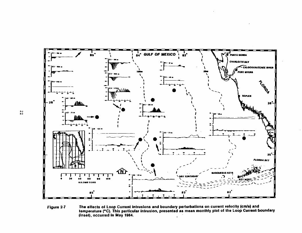
Loop Current boundary perturbations and subsequent intrusion on to the
southwest Florida shelf are important short-term phenomena . The
intrusion of a warm filament (see Figure 2-6) typically results in a
2° to 4°C increase in temperature, an increase in average current speed
by as much as a factor of 2, and a change in current direction
(Figure 2-7) . In addition, upwelling (see Figure 2-6) is frequently
associated with these perturbations ; this upwelling is an important
mechanism for importing nutrients onto the southwest Florida shelf .
These events typically last for approximately 5 to 10 days and can extend
across nearly the entire shelf, although they rarely intrude beyond the
20-m isobath .
Another Loop Current phenomenon is the shedding of large anticyclonic
eddies or rings of warm water (see Figure 2-6) . These rings are thought
to contribute significantly to the transfer of temperature and dissolved
constituents (and presumably organisms entrained in the rings) in the
Gulf of Mexico (Science Applications International Corporation, 1986) .
Although these rings are an important phenomenon in the Gulf of Mexico,
they do not impact the southwest Florida shelf .
20

9 "' 9d' 94' 92- 9a- so- se s~
N~uYiuL teas o w t2o
0 of 3W.
. " i .
" "' """" ' WARM FILAMENT 200 m .-
.:
LOOP CURRENT
STUDY AREA e
TEMPERATURE
I SALT ~1 MOMENTUM
fr "' ..rr
LOOP CURRENT RING
.~J COLD MEANDER
. .
0'
re' 1
14 .
tz'
20'
TEMPERATURE ("C1 GEOSTROPHIC CURRENTS (crNS*cl s n w B C
A
200
E 400
d W O
600
Ann
',14~ v v ~8~ - -
~ v ZZ w
. . ." .i .
/
40
.. .
14 20 '~I. . .
12 ; ; O »
10 : ti . .
8 _ + J
- :, :. : .; .r
o goo o goo zoo KILOMETERS KILOMETERS
Figure 2.8 Schematic representation of Loop Current features and dynamic processes (top) and a cross section through a warm filament (bottom) showing distribution of temperature (note upwelling between Stations A and B) end current velocity ( - denotes southward and + denotes northward).
21
N N
u-ws .
65e
u- v$
i e4- GULF OF MEXICO i e3 "
w ,7r~-w .
+ r
1
AD-w . 1 . ~yy 280 ..-» .
..- .,. ~ ~
M-4l~
]
r
, ~''']]] !7' /1 .
/, + 7J
1
w
o 2o 4o so so 1oo _---KILOYEiEIIf
J
es _-~.-_ :
1
01, 1
PUNTA GOWA
CHARLOTTISAY A L V
PUNTA
00'
a A C OOSAXATCHEE OUVRA SA
A LOTT"
FO OR
7
N
LES
FOOR MYRAS
T
a"
0 lk
C APLES 26!
z
N
FLORADA SAW
MAROUESAS KEYS \DAY TCMITUQAW
-KEY- 98T
830 62*
Figure 2-7 The effects of Loop Current Intrusions and boundary perturbations on current velocity (curls) and temperature (°C). This particular Intrusion, presented as mean monthly plot of the Loop Current boundary (Inset), occurred in May 1984 . 1

The passage of a hurricane or tropical storm across the southwest Florida
shelf is another important short-term phenomenon . As an example, the
passage of Tropical Storm Bob (Figure 2-8) in July 1985 increased mean
daily current speeds at some stations from 5 to 35 cm/s . The farther a
station was from the storm, the less pronounced were the effects of the
storm on current speed . The effects were also greater at shallower,
rather than deeper, stations . A 3 to 4°C change (both increases and
decreases) in near-bottom temperature accompanied the passage of the
storm . Temperature changes of the wine magnitude have been reported by
Leipper (1967) during the passage of Hurricane Hilda (1964) .
2 .3 HYDROGRAPHY, CHEMICAL OCEANOGRAPHY, AND HYDROCARBONS The nearshore environment (bottom depths less than 10 m) of the southwest
Florida shelf exhibits the greatest temperature variability both
seasonally and daily (following the diurnal pattern of air temperatures) .
According to Schomer and Drew (1982), Florida Bay water temperatures
normally range from a winter low of 15°C to a summer high in excess of 30°C . In the shallow waters of Florida Bay, temperatures as high as 38°C
(Schomer and Drew, 1982) and as low as 9'C (Walker, 1981) have been
recorded . Schomer and Drew (1982) also observed that in the shallow
water of the Florida Keys, temperature changes as great as 8°C can occur within 24 h . Water temperatures in the Florida Keys can drop as low as 10°C with the passage of cold fronts .
The remainder of the southwest Florida shelf (extending from the 10-m isobath to the 200-m isobath) exhibits some annual temperature
variability, but generally of a lesser magnitude than the nearshore temperatures . Surface water temperatures ranged from 20°C during the winter to 30°C during the summer . The variability observed in bottom temperatures (13 to 30°C) was more a function of depth of measurement than time of the year . Thermal stratification (approximately 0 .1°C/m) was evident during the summer . Generally, the surface and bottom temperatures were 2 to 4°C warmer from north to south . The surface mater
23

e4 ~ GULF OF MEXICO `~ e3 `\ w ""
~,~~, ~ ~ _ \ 1 \ r
r CI -N~ ~ ` ` ~. . ~ .
" ! - Wo ~ '
N r
26"
25"
. wro- ̀\
MmEs A . J ~ . ~ -.yam ~ ~ r 2
..
.~ u . t
N 1 " J " W~-
Ill 11 111IT-FT o :o 40 so so too
I(1.OYtlEllt
TROPICAL DEPRESSION
TROPICAL STORY
1
1 I
',7 ! \ It . " \
000,
C~
` . . , .1 . T . ~ S
., ., .-
1
I
-- y 1 -'_
i
25 -
i - - - - ~'
1 ~ YA"QUEiAi KEYS r .~ . . ,, .= - - , - -_- -KEr WEsi~ r
eZ "
Figure 2~e The affect of the passage of Tropical Storm Bob on current velocity and temperature during July 1985.

temperatures during the winter and spring were usually 2 to 4°C warmer
offshore ; during the summer, there was a 2°C increase toward shore .
During the fall, the temperature was virtually constant across the shelf .
The overall shelf salinity values for all seasons were within ±1 °/oo ;
however, within Florida Bay, Schomer and Drew (1982) reported salinity
values as low as 13 °/oo and as high as 66 °/oo during periods of high
precipitation and high evaporation, respectively . Generally, the
salinity distribution did not reflect the vertical stratification that
was apparent in the summer temperature distribution . There were no
obvious north-to-south geographic trends evident in the salinity
distribution ; however, there was a tendency for salinity to increase
seaward (by as much as 1 °/oo) except during the fall, when it decreased
by approximately 0 .2 °/oo .
Beyond the inner shelf zone (i .e ., beyond the 45-m isobath), water on the
southwest Florida shelf is comparable to values observed in the open
ocean (1-m beam transmissivity values in excess of 908) . According to
the data summarized by Woodward Clyde Consultants (1983), there was
little evidence of seasonal variation over the major part of the shelf ;
however, the isolated nearshore areas during the spring and fall appeared
more turbid [1-m beam transmissivity values as low as 408 (presumably
even lower values would be encountered within Florida Bay)] . According
to these investigators, there was progressively more structure or
variability in water clarity southward across the study area .
The compensation depth or lower limit of the euphotic zone (defined as
that depth at which only 1$ of the surface incident radiation is
received) is a function of water clarity (transmissivity) and color .
According to Pickard and Emery (1982), the compensation depth can range
from between 3 and 4 m for turbid coastal waters to approximately 100 rn
for the clearest ocean water . Across the southwest Florida shelf, the
estimated compensation depth ranged between 5 and 100 m . Stations
located in water depths less than 40 m were generally more turbid and,
25

therefore, had shallower compensation depths, with maximum values rarely
exceeding 45 m and minimum values as low as 5 m . This means that,
although the compensation depth probably exceeds the bottom depth (ioe .,
there is usually sufficient light for photosynthesis), there are periods
when photosynthesis would be retarded because of reduced light levels .
At the mid-shelf locations (water depths between 40 and 70 m), the
average compensation depth (50 m) probably was rarely greater than the
bottom depth . Nevertheless, algae such as Anadvomene not only exist, but
apparently thrive, at depths of 65 m, probably relying on the deeper
penetrating blue-green light almost exclusively . The outer shelf
compensation depths ranged from 60 to 85 m, with values of 100 m
occasionally observed .
Dissolved oxygen concentrations observed on the southwest Florida shelf -
range from 3 .8 to 11 .7 mg/1 (Marvin, 1955 ; Schomer and Drew, 1982 ;
Woodward Clyde Consultants and Continental Shelf Associates 1984 ; Danek
and Lewbel, 1986) . The widest ranges in dissolved oxygen concentrations
occur in nearshore areas of restricted circulation . On the open shelf,
the dissolved oxygen values generally range from 4 .4 t0 10 .3 mg/1 .
Dissolved oxygen data collected along a cross-shelf transect by Marvin (1955) revealed a distinct trend toward lower dissolved oxygen
concentrations in the estuaries and nearshore zone, with values increasing approximately 1 to 2 mg/1 offshore ; this occurs approximately 70$ of the time . Generally, dissolved oxygen decreases with depth and rarely exceeds 5 mg/1 at depths greater than 100 m .
E1 Sayed et al . (1972) reported that the upper 100 m of water in the Gulf of Mexico were nutrient poor, with phosphate, nitrate, and silicate values less than 0 .4, 2 .0, and 2 .0 micromoles (uM), respectively . Nitrate-nitrite nitrogen concentrations on the southwest Florida shelf ranged from less than 0 .1 to 19 uM ; however, the concentrations rarely exceeded 1 uM at depth less than 60 m . There were no obvious seasonal trends . Historically, the total phosphorus concentration ranged from 0 .05 to 1 .6 uM, with a mean concentration of 0 .3 uM for the upper 100 m
26

of water (Marvin, 1955) . The mean total phosphorus concentration at
depths greater than 100 m was 1 .0 uM (ranging from 0 .65 to 1 .6 uM) . One
trend apparent in Marvin's (1955) data was a 2- to 3-fold increase in
near-surface total phosphorus concentration shoreward of the 20-m
isobath . Silicate concentrations on the southwest Florida shelf ranged
from less than 1 to 13 uM, with values exceeding 3 uM only at depths
greater than approximately 60 m and shoreward of the 20-m isobath .
Generally, nutrient values are higher offshore at water depths greater
than 100 m. The higher nutrient concentrations are typical of deeper
water ; however,-the proximity of these offshore locations to the Loop
Current probably contributes to higher nutrient values . Physical
oceanographic investigations conducted by Science Applications
International Corporation (1986) suggest that upwelling resulting from
Loop Current boundary perturbations (e .g ., warm filaments (upwelling is
evident by doming of isotherms in Figure 2-6)J would bring up the more
nutrient-rich Subtropical Underwater onto the southwest Florida shelf .
Riley and Chester (1971) report that fertile coastal water in bloom may
exhibit chlorophyll values from 10 to 40 mg/m3 . According to Woodward,
Clyde Consultants (1983), chlorophyll values on the southwest Florida shelf range from less than 0 .1 to 1 .5 mg/m3 . The highest value is
approximately six times higher than the average gulfwide value reported
by E1 Sayed e1 al . (1972), but still considerably lower than the values for fertile coastal water . There was no apparent geographical or. seasonal trends with regard to chlorophyll distribution ; however, the
highest overall chlorophyll concentrations did seem to occur during the fall . Inshore of the 100-m isobath, the lowest chlorophyll values were recorded during the spring and were comparable to the summer values . For both seasons, the inshore chlorophyll values ranged from 0 .1 to 0 .5 mg/m3 ; this was approximately one-third the fall and winter
concentrations . This suggests that the phytoplankton bloom had been
missed either sometime in the spring or summer . Therefore, it is likely
that the maximum values reported by Woodward Clyde Consultants and
27

Skidaway Institute of Oceanography (1983) are low and should be
considered conservative when estimating the productivity of the shelf
water or comparing this productivity with worldwide values .
There are many sources of hydrocarbons that may result in ultimate
deposition in the marine environment : (1) biogenic, synthesized by
marine and terrestrial organisms ; (2) diagenetic, formed im situ
(primarily in the surface sediment environment) ; (3) pyrogenic, formed
during combustion of wood and fossil fuels ; and (4) petrogenic, resulting
from petroleum drilling, production, and use (anthropogenic) and from
natural seeps . ~A comprehensive review of hydrocarbon data for the
southwest Florida shelf revealed no evidence for natural seeps or for any
significant influx of anthropogenic petroleum contamination . High-
molecular-weight hydrocarbons were dominated by biogenic and diagenetic
compounds ; however, analysis of select polynuclear aromatic hydrocarbons
revealed small amounts of petrogenic and pyrogenic input .
The distribution of hydrocarbons in surface sediment of the southwest
Florida shelf according to source characteristics is shown in Figure 2-9 .
Three major source regimes were observed : (1) predominantly marine
biogenic, found primarily in the mid-shelf to outer continental shelf
areas ; (2) marine and terrigenous biogenic, found at the deepest stations
and those closest to land (<20-m depth) ; and (3) marine and terrigenous
biogenic with some petrogenic characteristics found in a few outer
stations influenced by transport from the Loop Current . Hydrocarbon
analysis of sediment on the southwest Florida shelf indicates the area is
relatively free of petrogenic hydrocarbons . Concentrations of total
extractable hydrocarbons generally fell in the range of 0 .5 to 2 ug/l,
with values decreasing with distance from shore . The source of
petrogenic hydrocarbons is attributed to pelagic tars transported by the
Loop Current, 50$ are estimate to enter the Gulf of Mexico through the
Yucatan Straits .
28

- . 85 PUNTA GORDA
'r`~ CHARLOTTE 2101 7
CALOOfANA1CNEE RIVER
p~~ ~'I FORT YrEll" I . .
~!E
O
sad t
fJ
zs'
KEY
IuIAFLA OCS Environmental Survey
S.W. Florida Shelf Study, You 1
S.W. Florida Shell Study, Year 11
S.W. Florida Shell Study, Year ill
Charlotte Harbor Study
Marine Marine Blogenic
and Tsrdyenous Bbgenlc ( ::; : : : ; .:; ; : ; : : : : : : : : :: : ; : : . : : : ; ; :, . . . . Yulne and Tarriganous ~ . Blogenlc with some PaIroyenk characteristics .:~ .~ .~.~ .~ . .~ .~ .~ .~.~ .~ .~ .~ . .i~ .~ .~ .~ .~ .~ . .
o 20 40 60 so goo UIlOYf1E11"
10 20 30 40 so 60
. .
18
IXI
20
8 2* 85 84 B3
50
Figure 2-9 Surface sediment sample stations and hydrocarbon source characteristic distribution .

In both the demersal fish and macroepifaunal invertebrates, the
hydrocarbon composition reflected that found in surface sediment, with
seasonal and interstation variability indicating acquisition from benthic
dietary sources rather than from the water column (Dames and Moore,
1979) . The lack of petrogenic contamination in biota indicates the
absence of petrogenic hydrocarbons in the water column as well as in
sediments .
Studies of pelagic tar (anthropogenic or, less likely on the southwest
Florida shelf, from natural seeps) in the eastern Gulf of Mexico show
high concentrations in the Loop Current (0 .6 to 2 .2 mg/m2), with low
concentrations recovered from the southwest Florida continental shelf
(<0 .1 mg/m2) (Jeffrey, 1980 ; Van Vleet et al ., 1984) . About half the tar
in the eastern Gulf of Mexico Loop Current system appears to enter the
Gulf through the Yucatan Straits (Van Vleet et al ., 1984) . Although most
pelagic tar in the Loop Current is transported out through the Florida
Straits (much of which is blown ashore onto the Florida Keys and
southeastern Florida beaches), infrequent tar loading does occur along
the southwest Florida beaches, primarily from tanker washings during a
prevailing westerly wind (Romero et al ., 1981 ; Atwood et al ., 1986 ; Jan
Vleet and Pauley, 1986 ; Pierce, unpublished results) . In addition to
presenting an aesthetic nuisance to coastal residents, bathers, and
boaters, pelagic tar has been implicated in the deaths of sea turtles
along the southwest Florida and southeast Florida coasts (Van Vleet and
Pauley, 1986) . .
The distribution of dissolved and dispersed petroleum hydrocarbons in she water column of the eastern Gulf of Mexico follows the distribution of pelagic tar . Highest values observed were in the southern Florida Straits, whereas very little was found in the southwest Florida shelf area (Atwood et al ., 1986) . Although the source for dissolved and dispersed petroleum hydrocarbons could not be established, the correlation with pelagic tar would implicate tanker discharge as a major contributor in the Yucatan Straits and the Straits of Florida .
30

2 .4 INFAUNA AND SESSILE EPIFAUNA
Infaunal densities on the shelf range from about 1,000 to 14,000
individuals per square meter and generally decline with increasing water
depth . Some species, especially spionid polychaetes such as
Paranrionospio vinnata and Prionosvio cristata , fluctuate widely in
abundance . Polychaetes account for about 64$ of the individuals
collected and 378 of the species (Table 2-1) . Polychaete biomass is
typically <20 g wet weight/m2 and decreases with increasing water depth .
Most of the infaunal individuals collected are deposit feeders . The
polychaete families Paraonidae (burrowing, subsurface deposit feeders)
and Spionidae (tubicolous, surface deposit feeders and/or suspension
feeders) are well represented in the list of most abundant species .
Species composition of infaunal communities varies primarily in relation
to water depth and, secondarily, grain size composition of sediments
(particularly silt content ; see Figure 2-10) .
The southwest Florida shelf is characterized by a diverse sessile epifauna . Schematic representations of the biotic zonations for hypothetical northern and southern transects across the southwest Florida shelf are presented in Figures 2-11 and 2-12, respectively . The subtropical climate and the widespread occurrence of various hard substrates favor colonization by species of scleractinian corals, gorgonians, and sponges typically associated with Caribbean and south Florida reefs .
Most of the inner and middle shelf (to a depth of about 70 m) consists of a mosaic of sand bottom and hard bottom covered by a thin sand veneer,
with occasional low-relief rock outcrops . Hard-bottom areas near shore
(<20 m depth) are typified by dense populations of gorgonians, large
sponges, and small scleractinian corals . Areas of open sandy bottom in the same depth range are colonized by various species of macroalgae and seagrass (Halophila decipiens) . The gorgonians and seagrass become much
31

Table 2-1 . List of most abundant infaunal species .
Number Grand Mean of Abundance Life Feeding
Species* Stations (No ./m2) Mode** Type***
Prionospio cristata (P) 26 334 T DF/SF Smelmis alb'n (P) 29 314 B C/S Mediomastus californiensis (P) 30 160 B DF Paraprionospio pinnata (P) 25 142 T DF/SF Armandia maculata (P) 30 112 B DF Cirroghorus americanus (P) 26 109 B DF Myriochele ocu ata (P) 30 108 T DF Fi1o¢rana im ex (P) 8 91 T SF Aricidea fra ig lis (P) 24 84 B DF Haplosvllis svongicola (P) 21 83 F C/S Lucina radians (B) 12 79 B SF Prionospio cirrifera (P) 23 67 T DF/SF Cvclaspis sp . A (C) 20 66 B DF Goniadides carolinae (P) 15 66 B C/S Kagelona pettiboneae (P) 18 62 B DF Lumbrineris verrilli (P) 25 48 F C/S Leptochelia sp . A (T) 21 47 B C/S Aricidea catherinae (P) 26 44- B DF Levinsenia gracilis (P) 19 43 B DF Axiothella sp . A (P) 28 42 T DF Ceratonereis irritabilis (P) 4 42 F C/S Aricidea to o (P) 18 41 B DF Ceratoceohale ocu at (P) 21 41 F C/S Sigambra tentaculata (P) 18 41 B C/S
*B - bivalve, C - cumacean, P - polychaete, T - tanai d . **B - burrower, T - tube dweller, F - free surface dwe ller .
*-ti*C/S - carnivore/scavenger, DF - deposit feeder, SF - suspens ion feeder .
32

w w
as* KEY
-~ FIRST LEVEL STATION GROUPING
SECOND LEVEL STATION GROUPING
~ 5 MEAN SILT CONTENT Of SEDIMENT
26~
" GULF OF MEXICO ~ 83 PUNTA GORDA
1 CNARLOIfE MAAIOA
i 13 ~ 7 "
~ O " CA100lANAfCM18 RIVER l10~ : loom ~
I0~ FORT MTSRG
1 1 t: ~.:~:~ ~ G 1.~
SEASONAL STATION GROUPING I i N ' . NAPLES
6 13 (3 0
I ' ~ . : .y. .
1 ! I
"S . . .t . . , j ., .q .
. : . e Z
. .~ . Y!t. . .S ' 7 ~..i .
\ .. 25 '-. . ~. . .
LOCATION MAP
err
f
I
7
STUDY ARIA
23' so, 114- $3, w
59 " ~. 30 FLORIDA u, :
. . . ~ .: NAUTICAL Y1 His i s . . 60:' ~ : . /j\\ ~7:'7 . 4 0 to 30 30 40 so 60 0
. . tAII KIrJ
~DAY TOIITWA "' 0 70 40 .0 so 100
IIIIOYtT(Ilf -. .""
es' e4' e3* 82'
Figure 2.10 Station groupings from normal classification analysis of Inlaunal date.

W r
Figure 2-11 Biotic zonatlon of the southwest Florida continental 'shell (northern transact, e.g ., Transect A) showing general distribution patterns of major components of the flora and fauna.

w
p
w
~ IRS
1s
Sao w
Uw
,' KEY
W tEAOMSiF"
c~u fOL10fE AIYA!
ANADYOYENE
t`~ NEWS CORALS
APHOTIC ZONE
AIOAI NOOUIf"
PNOIO.1f11iNEllG OOIIOONIAN"
HIRMATIFIC CORALS
100
TWILIGHT ZONE
LAR09 SPONGES NON"NOiO"YNTNfTIC OOIIOONMNt
~{ cRuwaos
It M 1"
EUPHOTIC ZONE
ANFIIYATYIIC CORALS /W4< SMUT LONSTENG
'va` PINK SHAMAP 4V,-- SNAPPERS AND GROUPERS
~-~ fi011E CRABS C: -t YACUEIIfIi
Figure 2.12 Biotic zonation of the southwest Florida continental shplt (southern transact, e.g ., Transact E) showing general distribution patterns of major components of the flora and fauna .

less common with increasing water depth seaward of the 20-m isobath, but
many other elements of the sessile epibiota extend across much of the
inner and middle shelf .
A different suite of sessile epibiota is found in the 60- to 100-m depth
range in association with coralline algal nodules, which occur in
greatest density south of 25 .5°N latitude . Sparse populations of sessile
epifauna such as sponges, nonzooxanthellate gorgonians ;, scleractinian
corals, and crinoids are present in the nodule areas, but the most
conspicuous epibiota are species of algae ( Anadvomene menziesii ,
Peyssonnelia rubra , and E . simulans ) . At the southern shelf edge in the
64- to 80-m depth range, the coralline algal growth forms a continuous
pavement, and dense accumulations of plate corals ( Agaricia) are seen .
Biotic coverage in this area is the highest on the shelf (64 to 90$),
with most due to the algae cited previously .
Much of the outer shelf is covered by a sand veneer ; scattered rock outcrops occur, but most are concentrated along two partially buried
north-trending reef features . The most important is Howell Hook, which was observed in a water depth of about 150 m in the form of steep-walled rock prominences protruding several meters above the surrounding sandy bottom . Common sessile epifauna on the outer shelf, both in association with rock outcrops and with areas of coarse shell rubble, are comatulid crinoids, hexactinellid (glass) sponges, antipatharian sea whips, and nonzooxanthellate gorgonians .
The availability of suitable substratum is an obvious influence on the occurrence and species composition of sessile epifaunal communities . Many species can colonize only bare rock or areas where the sand veneer is thin enough to allow intermittent exposure of hard bottom . Several environmental variables related to water depth are also influential, the most important being light . Many species of hard coral, gorgonian, and sponge harbor symbiotic algae and are light limited in their distribution .
36

2 .5 MOTILE EPIFAUNA AND FISHES
The depth zonations presented in Figures 2-11 and 2-12 are generally
appropriate for sessile epifauna ; however many motile epifauna may be
found at most locations . The reason for this is the majority of large,
motile epifaunal species are sand dwellers . Calcareous sand is the
single universal benthic habitat type on the shelf . Thick or thin layers
of sand can be found at every location examined, even where high-relief,
hard-bottom, algal nodules, or Agaricia beds are prevalent . Most live-
bottom communities on the shelf consist of various species of long-lived
sessile invertebrates or plants anchored to hard substrate and projecting
through a thin layer of sand .
For motile invertebrates, it is perhaps more appropriate to define only
two benthic habitats : high- and low-relief bottoms . Most of the motile
invertebrates that have been described are confined to, or most abundant
on, sand, whether or not it is adjacent to coral, limestone outcrops,
etc . For a few of the larger motile invertebrates, such as lobsters and
some sea urchins, the shelter and food that high-relief substrates can
provide are certainly important . However, many of these motile
invertebrates are closely associated with the surrounding sand, also .
High-relief bottom refers to areas of coral and limestone outcrops projecting upward from the surrounding bottom and generally permanently exposed or free from sand burial . High-relief bottom provides large holes, overhangs, and crevices where fish and large, motile epifauna can find shelter, as well as substrate for long-lived sessile epibiota such as corals, gorgonians, and sponges .
Large, motile epifaunal organisms most frequently found on or near high-
relief bottom include palinurid and scyllarid lobsters (Panulirus argus , _P . guttatus , Scvllarus spp ., and Scvllarides s pp .), brachyuran crabs ( Stenocionoos urea a and many other smaller species), and sea urchins ( Diadems antillarum , Arbacia punctualata , and Eucidaris tribuloides ) .
37

Many of these species are more abundant in shallow water (e .g ., less than 60 m deep), due to herbivorous diets and the greater availability of
plants in shallow water .
Low-relief bottom refers to areas of partially buried limestone, coral or
algal debris, and sandy substrates . Seagrass beds are included in the
definition . Most of the shelf can be defined as low-telief bottom .
Large, motile epifauna likely to be encountered frequently on low-relief
bottom include many asteroids (Astrovecten spp . and Ojeaster reticulacus )
confined to sandy patches or seagrass beds, as well as sea stars such as
Echinaster and Luidia that may be found either on sand or consolidated
substrates . Most asteroids have a broad depth range due to the
opportunistic, predatory diet and are found throughout most of the shelf .
Some species of asteroids are most abundant or confined to water deeper
than 60 m, such as Henricia antillarum , Narcissia trigonaria , Pectinaster
gracilis , and Sclerasterias contorts . Habitats in deeper water that
harbored many asteroid included the Middle Shelf Algal Nodule Assemblage
and sand .
Echinoids typical of low-relief bottom include many irregular burrowing
species such as Clv2easter spp ., M ma ventricosa , and o e spp . that
are found only in sand . Regular (echinacean) echinoids include those
mentioned as common on high-relief bottom and other species, such as
Lvtechinus spp ., that are also at home in seagrass beds, sand flats, and
other low-relief areas . Most urchins have very wide depth distributions
(with some exceptions such as the deepwater forms, e .g ., Echinolampas
depressa , Stvlocidaris spp .) . The majority of urchins collected off
southwest Florida are primarily herbivorous, but are not necessarily
confined to hard substrates ; drift algae and smaller plants growing on
stable sand can also provide nutrition .
Larger holothurians (sea cucumbers) are abundant in low-relief areas of the shelf . Most of them (e .g ., IsostichoDus badionotus ) ingest sand and
38

extract organics and are found in locations of unconsolidated sediment
over a wide depth range .
Portunid and calappid crabs are also found primarily in sandy areas where
they can burrow and cover themselves . . Large hermit crabs ( Paguristes
spp ., Pagurus spp ., and Dardanus spp .) are found on soft bottoms and in
seagrass beds . Hermit crabs, portunids, and calappids have wide depth
ranges, probably as a result of their broad dietary range . Stone crabs,
Menipve mercenaria , are common only in the inshore portion of the study
area .
Within the study area, the Tortugas grounds and the Sanibel grounds are
Florida's most productive areas for pink shrimp ( Penaeus duorarum ) . Both _
areas combine suitable substrate characteristics with proximity to
estuarine nursery grounds ; Florida Bay lies north of the Tortugas
grounds, and the Sanibel grounds are located west of Charlotte Harbor-
Tampa Bay estuaries . Pink shrimp are dependent on these inshore,
estuarine nursery areas for the growth and survival of young stages,
which undergo an ontogenetic migration from inshore nursery habitat to
the offshore spawning grounds (Costello and Allen, 1966) . Spawning
occurs in oceanic water 4 to 48 m deep throughout the year . The larvae
are transported by currents from spawning grounds to nursery areas in the
Everglades National Park . Young spend 2 to 6 months in nursery areas
before migrating offshore . Adults prefer calcareous sand bottoms .
Gastropods such as conchs ( Strombus spp .) are also confined to soft
bottoms and seagrass beds . Since they are herbivores, they are
especially abundant in water less than 40 m deep .
Like motile epifauna, the distribution of fish does not fall easily into
established assemblages or biotic zones . There have been a variety of
schemes proposed to divide or categorize the benthic habitats of the
southwest Florida shelf . Most of them have focused upon major
topographic features, suites, or assemblages of characteristic epifaunal
39

organisms . Nevertheless, it should be remembered that fishes are capable
of moving rapidly between habitat types and that apparent boundaries of
zones are not absolute barriers . Continental Shelf Associates (1986)
attempted to integrate a set of visually designated assemblages with the
results of cluster analyses in order to produce a new, proposed zonation
scheme for the shelf . This scheme is used in a brief description of fish
by habitat type and depth range that follows .
Within the inner shelf zone (approximately 10 to 45 m), considerable
variability was present between different habitat types . Fishes
associated with coral reefs--some of which are numerically dominant in
this zone--are known for fine-scale partitioning of habitat utilization
(cf . Alevizon &t al ., 1985) . Some species within this zone showed
preferences for the shallowest stations (13 to 20 m), while others, such
as Lutianus s r~iagrj�s (lane snapper), Haemulon plumierl (white grunt), and
H . aurolineatum (tomtate), ranged across the zone . Others were more
common coward the outer edge of the inner shelf zone, such as Ioglossus
calliurus (blue goby) .
The middle shelf zone spanned depths from 45 to 100 m and was divided into two sections : Middle Shelf I (45 to 60 m) and Middle Shelf II (60 to 100 m) . Fishes typical of Middle Shelf I communities included the bank sea bass ( Centrogristis ocvurus ), the horned whiff ( Citharichthvs gymnorhinus ), various priacanthids (bigeyes, etc . ( Pristigenvs a ta, Priacanthus spp .)], and butterflyfish (chaetodontids) . According to Continental Shelf Associates (1986), Middle Shelf II was a special category for algal nodule and algal pavements (some bearing Agariciid plate corals) ; areas between 60 and 100 m without algal nodules or pavements were not defined by the scheme . Fishes found primarily in the Kiddle Shelf II zone included many damselfishes, such as yellowtail reeffish ( Chromis enchrysurus ), purple reeffish (C . scotti ), and sunshinefish (_q, insolatus ) ; anthids and other serranids, such as saddle bass ( Serranus notospilus ), tattler (§ . phoebe ), orangeback bass (S .
40

annularis ), and chalk bass (S_ . tortugarum) ; the boga ( Inermia vittata) ;
and the greenblotch parrotfish ( SRarisoma atomarium ) .
It is likely that many more species and individuals occupy areas of
nonconsolidated algal rubble and A_garicia than consolidated algal
pavements due to the greater availability of suitable refuges within
nodules and living and dead coral debris (viz . Shulman, 1984) ; however,
none of the sampling methods used to date are ideal for surveying this
complex habitat, and it is probable that many species of small fishes
escaped collection or observation in the Middle Shelf II environment .
Characteristic fishes from the outer shelf zone (100 to 200 m) included the tattler ( Serranus phoebe ) and other small serranids such as the _
roughtongue bass ( Holanthias martinicensis), offshore lizardfish ( Svnodus
poeyi), searobins [e .g ., the shortwing searobin'( Prionotus stearnsi ), the
shortfin searobin (Bellator brachvchir), and the streamer searobin
( Bellator egretta)], batfishes (Ogcocephalus corniger , Halieutichthys
aculeatus ), and the bank butterflyfish ( Chaetodon aa) .
Many fishes had depth ranges that extend across these zones . Examples of
ubiquitous species included the fringed filefish (Monocanthus ciliatus ),
sand diver ( Synodus intermedius ), dusky flounder (Syacium gapillosum ),
blackedge moray (Gvmnothorax nigromarginatus ), jackknife-fish ( Eauetus
lanceolatus ), red grouper ( Eginephelus mo o), scrawled cowfish
( Lactoohrvs auadricornis ), gray angelfish ( Pomacanthus arcuatus ), and
reef butterflyfish (Chaetodon sedentarius ) .
2 .6 FISHERIES/SOCIOECONOMICS
Commercial and recreational saltwater fishing activities are important elements of the economy in southwest Florida . The diversity of offshore and coastal habitats supports a variety of economically important species of fish and shellfish .
41
Recreational fishing is a substantial component of Florida's economy, and
southwest Florida is one of the most active areas in the state for
anglers . More than 625,000 saltwater anglers in southwest Florida spent
over 10 million man-days fishing during 1980-1981 . Most fishing days
were spent on surf, shore, pier, jetty, or bridge fishing . Offshore
fishing also is important, with charter and party boats operating
primarily out of Fort Myers, Marathon, and Key West .
In 1985, Florida's marine commercial fishery was ranked fifth nationally
in value of dockside landings ($171,073,000) and ninth in poundage
(182,577,000 lbs) . Within the study area, Monroe County leads in volume
and value of fish and shellfish landing, and Lee County is ranked second
(see Figure 2-13) . Key West and Fort Myers are the primary ports for
landings .
Economically valuable finfish species can be grouped by habitat . Inshore
species include red drum, spotted sea trout, spook, striped or black
mullet, tarpon, pompano, black drum, and sheepshead ; although some are
harvested commercially, all but sea trout and mullet are sought primarily
by recreational anglers . Coastal pelagic fishes, which traverse coastal
and inner shelf water during their life spans, are represented by
Spanish, cero, and king mackerels ; bluefish ; little tinny ; and cobia .
Economically, the Spanish and king mackerels are most important ; both are
sought by commercial and recreational fishermen alike . Valuable reef
fishes include snappers, groupers, grunts, porgies, barracudas, and
jacks . Groupers ( Epineohelus spp ., Mycterooerca spp .) and snappers
( Lutjanus spp ., Ocvurus chrvsurus , Rhombo ites aurorubens ) are the most
sought-after reef fishes and have been subject to intense fishing
pressure . Other reef species are becoming increasingly important as
snapper and grouper stocks decline .
Shellfish harvested in the area include pink shrimp ( ?enaeus duorarurn ),
spiny lobster ( Panulirus ar us), and stone crab ( Menippe mercenaria ) .
The pink shrimp fishery is the most valuable on the southwest Florida
42

FiNFiSF1 LANDINGS, 1981-1983
.0
a 0
caujan a "I haos"We
DOLLAR VALUE OF f1NF13M LANDINGS, 1981-1983
0
e
r i O
Z 7
G
0
ounce 11111,93 N ~ ~a :o m .o b w r a o m b .o ' .o 00 z
4 \ `{ n tern p ~ cn
D
~ / CMYIOfTt
~F t
weep I
[r ~car
SHELLFISH LANDINGS, 1281-1945
" . . a o to
0
it ., e
a
a O c~~~~orn . ua p co~~r~ / rpwoi
DOLLAR VAGUE OF SHELLFISH LANDINGS . 19x1-1985 .s
i
to 0
a
s . .
0
C CN ""LpTTf p Cowan else " W40"Nos
"" VtIC "l
N ~~.` a z a _ n~or~rt~t , �
c;
r Y a o t&rr&
d~~~ ~ ` a a \ 2
l 7
rs eau,r~l
1
l
)v1F~ / ~
i~t ~l1T
Figure 2.13 Commercial Finfish (top) and shellfish (bottom) landings in millions of pounds and millions of dollars by county.
43

shelf in terms of volume and value ; Monroe County landings in 1985 were
more than 20 million pounds, valued at $32 million . About 488 of the
harvest comes from the Tortugas grounds ; the Sanibel grounds off
Charlotte Harbor account for another 28$ . The second-ranking spiny
lobster fishery is concentrated in Monroe County (1985 value of
$8 million) . Adult spiny lobsters, which congregate under rock ledges
and coral heads during the day and emerge at night to forage over
adjacent sand bottom or seagrass flats, are taken mainly by wooden slat
traps and divers . Stone crabs are abundant in coastal seagrass beds off
southwest Florida ; the crabs are caught in wooden slat traps, declawed,
and returned to~the water . Fishing effort is concentrated in shallow
water from northern Florida Bay and west of the Ten Thousand Islands from
Cape Romano to Cape Sable ; over 508 of the state catch is landed in
Collier and Monroe Counties .
2 .7 ENDANGERED SPECIES AND AREAS OF SPECIAL CONCERN Florida's geographic position, geologic history, and habitat diversity
favor the existence of vertebrates and plants having specific habitat
requirements . As habitat degrades or disappears, such species become in
danger of extinction . The most recent federal listing of endangered
species includes six mammals, four birds, and five reptiles that may
occur over or in water of the study area .
The endangered mammals are five species of whales (fin, blue, humpback, right, and sei) and the West Indian manatee . The whales are open-ocean mammals that might enter the study area during annual movements . The manatee population, estimated at 350 to 400 animals, is restricted to coastal waters . Most of the manatees are located in the brackish water of Everglades National Park and the Ten Thousand Islands region .
Everglades National Park and the Ten Thousand Islands region are also known nesting and roosting havens for many water bird species, four of which--the brown pelican, the southern bald eagle, the least tern and the peregrine falcon--are endangered . Both the brown pelican and the bald
44

eagle nest in mangrove trees . Peregrine falcons have been reported in
the Dry Tortugas .
The endangered reptiles are four species of sea turtle (green, Kemp's
ridley, hawksbill, and leatherback) and the American crocodile . Of the
sea turtles, only the green turtle is expected to occur commonly in the
study area, where it migrates to nesting sites on the beaches of
southwest Florida . The American crocodile, an inhabitant of coastal
rivers and swamps, occurs in Dade and Monroe Counties, where the
population is estimated at 200 to 400 individuals . Nesting is apparently
restricted to eastern Florida Bay and southern Biscayne Bay and takes
place in April .
In addition to endangered species, several areas of special concern occur
within the study area . These areas are considered biologically valuable
and/or particularly sensitive to impacts from continental shelf oil- and
gas-related activities . The areas discussed include the Tortugas and
Sanibel pink shrimp grounds, seagrass meadows, mangrove forests and tidal
marshes, and coral reefs (Figure 2-14) .
Pink shrimp are the most important commercial fishery species on the
southwest Florida shelf, and most of Florida's pink shrimp catch comes
from the Tortugas grounds (48$) and the Sanibel grounds (28%) . The
importance of coastal areas in Florida Bay as nursery habitat led the
State of Florida and the U .S . Department of Commerce to establish the
Tortugas Sanctuary in 1981 as an area closed to shrimp trawling .
Seagrass beds provide food and habitat for many species of fishes and
invertebrates . Extensive seagrass meadows consisting of mixed
associations of turtle grass ( Thalassia testudinum), Cuban shoalgrass
( Halodule wrightii ), and manatee grass ( Svringodium fiLiforme ) occupy
most of Florida Bay to a depth of 10 m . Seagrass cover within this area
is estimated to be about 550,000 ha . Between Cape Sable and Tampa Bay,
seagrasses are confined mostly to inshore lagoons .
45

830 J~ TAMPA 82*
E-27°
E- 2 6 °
~- 25°
a 10 eo°
` *",
saaasora Q ~ . BAY ~
VENICE ' . .
CAKE - 27°
; HARLOTTE , OKEECIMBE
~HAf7BOR
. .
. ' PALM BEACH :
~FORT . .
.
° ' ~ MYERS
" SANIBEL ~ ISLAND .
APLES
1a° ' ' EVERGLAOES
CAPE ~
.,CITY ROMANO MI AMI U
TEN THOUSAND ' BISCAYNE ISLANDS SAY
`°,.EvERGLa0E5 NATIONAL ' PARK
_ .c~X\
DRY TOFiTU6AS . . . e " " ~ ''r
CAPE SABLE
MARATHON
KEY CARGO
2S°-
MARGUESAS KEY~~" KEYS WEST KEY
\~ FLORIDA 11[Qf TRACT
NAUTICAL Wlli _ .
0 +o 30 70 40 SO GO ~ltACn" 33tS
240 i . i . I ' I
MANGROVE 3 0 20 .0 .O 10 100
R0.0r4Tt113
Z a =l
Figure 2-14 Locations of environmentally sensitive coastal habitats in Southwest Florida.
46

Mangrove forests consisting of red, black, and white mangroves occur
interspersed with tidal marsh vegetation along most of the coast in the
study area . Over 75$ of the mangrove acreage in Florida occurs in the
coastal counties of the study area (greater than 200,000 ha) . Mangrove
forests are considered important as wildlife habitat and as producers of
detrital carbon . Tidal marshes occur along some 13,000 ha of shoreline
in the study area .
The Florida reef tract forms a 200-km, 6-lm-wide arc parallel to the east
coast of the Florida Keys from Fowey Rocks to the Dry Tortugas . Four
coral community types have been recognized within the reef tract : live
bottom, patch reefs, transitional reefs, and bank reefs . Similar reef
development occurs in a 22,000-ha area around the Dry Tortugas . Various
species of scleractinian corals, octocorals, sponges, and algae occur in
these reef areas .
3 .0 POTENTIAL OIL AND GAS DEVELOPMENT IMPACT PROJECTIONS
The goal of this section is to present projections of potential impacts
that might be expected if major oil and gas development of the southwest
Florida shelf proceeded . Impacts were estimated primarily for localized
areas or specific ecological compartments, again assuming oil and gas
development proceeds . The assessments are generic in nature ; therefore .
they may differ somewhat from the specific Planning Area Impacts
generated by Minerals Management Service (hMS Environmental Impact
Statement for Sales 113/115/116 ; for specific information on impacts from
the eastern Gulf of Mexico for the Sale 116 proposal, refer to that
official document which is in preparation as of March 1987) .
The delineation and distribution of distinguishable biological
communities and the physical factors that determine the distribution of
these communities are discussed in Section 2 .0 ; the distribution of the
live-bottom communities is summarized schematically in Figures 2-11 and
2-12 . In this section, the potential impacts of oil and gas development
47

on the southwest Florida shelf habitats, ecosystems, and valued ecosystem
components will be discussed in light of the information presented in Section 2 .0 .
The first step in the projection of potential impacts resulting from oil-
and gas-related operations involves identification of specific activities
resulting from each phase of these operations . The phases (exploration,
development, production, and transport and storage) and the activities
and potential habitat impacts associated with these activities are
presented in Table 3-1 .
Potential ecosystem impacts associated with oil- and gas-related
activities (summarized in Table 3-2) are derived largely through habitat
impacts . Although much information is included in Table 3-2, the
potential ecosystem impacts .could be expanded several times to include
all known potential effects of all known agents (particularly the
chemical species associated with oil and .gas operations) on various
biological components .
The deficiencies of tables such as these stem from their general nature .
It is virtually impossible to list the individual components of an
ecosystem and the potential impacts that oil- and gas-related activities
may have on each component . A more useful approach, and the one used for
this study, is to select a discrete and manageable number of valued
ecosystem components (VECs) . VECs are those species, groups of species,
or other ecosystem features that have been identified as being of special
importance for a given ecological analysis . The importance may stem from
economic value, rare or endangered status, dominance or prominence of
ecological role, or sensitivity to environmental disturbance . The VECs
for this study were selected by representatives from the U .S . Department
of the Interior (MMS and USFWS), Department of Commerce (NMFS), the State
of Florida (Office of the Governor), and the project ream . The list of
VECs selected for the southwest Florida shelf includes the following :
48

sa
S s!]~,
Of '
~s 7
A, 1
s
as ~
as r
r
1 1
1 y ~p ~p p~a~p`9'p~~9,
7 7
}('
BB9
O v O
. M
O
"J e
O
E ~
k p
,,cc ~
.Ib U
l= r
~+ 899
9 ~,
~
r ̀l
r'1
n
~C C~~ B~~
C C
~JV
n r
,
G
Y
n J~ ?
R
R 1 ~ ~ a X11
W I
II
14
Y
9
r 1
M x
p~~7,/,
U
5}}[[[~~~
Y
V
~
~
[[~77
~l~+
7
"̂~6
6
0 0 Y
7
0 a 0 c
w n a i

Table 3 .2 . Potential impacts of oil- and gas related activities on ecosystems of the southwest Florida continental shelf .
Factor Potontist Ecosystem Effects and considerations
safe* end disturbance from Impacts net known, but disturbance could interfere riot behavior of some increased offshore higher animals (i .e ., feeding, migration, reproduction, ate .) of marine activities mammals .
Chemical pollution 1 . Hydrocarbons Hydrocarbon impacts are poorly known for tropical wst*rg .
TAB most severe hydrocarbon impacts are likely to occur in shollor +arine rat "rs, Slang the shoreline, end in bays and estuaries .
Floating fractions can cent seabirds and asome1s and also impact digestive systems . "@eeisfng mixed With sediment particle*, these fractions gain density end ultimately slot to cont"sofnoto the bottom .
Dissolved hydrocarbons contain toxic components that sP0eiticSllY aou0@ len"del tissue and reduce recruitment but [end to be quickly dituted .
"oct0w animals, such as carets, exhibit greater mucous production, citiory activity . and pulsation, as moll as an Increased demand for *nylon whom exposed to hydrocarbons .
Mighty mobile animals, such as Pelagic flsn*$, tuna to avoid siaior oil spill
Invertebrates at ill levels soy suffer reduced reproduction, larval mortality . settlement difficulties, and reduced juvenile growth .
2 . S " rage end garbage Those factors eight result In the presence at foul toed supplies in the frees rift, platform*, water column end on the bettor . boats, end ships
This organic motorist way attract debits on,uls end concentrate [hem orww" the rigs and platform@ .
l . Other chemical t qaee$ ore poorly known for tropical water$ . pollutants
Some drilling fluid and produced water system additives (@ .I ., bieeides) are higlilY toxic is best Serino animals and represent the most dangerous group of Likely chemical pollutants .
Heavy metals eon teach frees structures and the metallic debris that accumulates an the bottom .
Ull" W "shIng$ May Contain Olt Of the above Plus other Unknown Chemical pollutants .
Such chemicals way be expected to cause highly tocstized mortality . to reduce food su0Pl1e" ~sltghtlY, and to perhaps concentrate wo food chains to the higher
predators (* .9 ., stone crabs, groupers, and mackerels) that may reores*nt human food sources ( .0* Msaai .aieen, 1v8i) .
Increased suspended Impacts tend to e. very iee .i, @Specialty consi dering that they are subject sediment to resusponsion and transport .
Increased suspended matter would reduce tight oonetration end inhibit
phetesrnthesis In silos . heru ty0it carets, photosynthetic lorgonions, ate ., many at which are already living moor their lover limit of light 4ttLization . Thus, there could be increased mortality of those photosynthetic species im
the deeper portions at their present ranges, if episodic dioCharles are prolonged .
Increased suspended matter could clog tee delicate feeding escitanisms of
lerves, and other taeplanttors, thereby Influencing vatuabl* species directly so well as indirectly through reduction of food supplies .
Suspended sediments tend to adsorb tonic chemicals and . It Ingested, could
e . toxic re var ious museum , fitter, and other feeding types .
Increased host from OIL Most tropical species live moor their upper Limits of thermal tolerance, and
end gas l, ef even small increases in temperature COU10 prove fats( . Such effect %h0.td
be 01 local occurrence .
50

Table 3-2 (Coot .) .
Factor Potential Ecosystem Effects and Considerations
Mechanical damage to the Cutting, scraping, and breaking of attached p*nthie Species (* .y � corals, bottoms oergenions, and sponges) result in direct damage, infection, and
dislodgement . this destroys the larger species and reduces the habitat of a
host of smaller cryptic sO*efos which are important fn the food chains . [A addition, there may be toss of habitat for young and/or adult store cribs, spiny lobsters, groupers, and other Large species .
Bottom ehannslitation Construction involving cutting, dredging, and *poll placement would destroy
wed habitat and many penthte communities In a liner pattern .
The resulting trenches might influence migrations of sued species as the pint shrimp .
Channels could provide additional habitat for adult stony crabs and other
species .
mechanical cluttering Bottom clutter could cause increased mortality in foul motive berithic
of the bottom communities . Out would provide hard substrate for attachment of fouling
organisms and eight add to Local Michas and food supplies .
Notallie debris could be a sourer of heavy metals teschate .
Bottom sedimentation Impacts would Likely be local . even considering that the Sediments would be subject to resusponsion and transport .
Moot N this bottom 1 " calcareous and t"" r"" trained vita wait oxygenated
crevices eotreen the grains . heavy sedimentation by ffn9-1fs(n*d material eight blanket this substrate with noeealear*ous sediment . This o.Ld he.*
many deleterious effects .
Reduced tight penetration could cause stress or mortality In Sony
photosynthetic speciets .
Int*r " tltial N Crof wn " could be smothered, thus reducing the feed Supplies of Oenth1e species .
Attachment sites for Larvae would be greatly reduced .
Smaller attacked species and the young of larger species would be subject to OurSaI and reduced oxygen supplies, at Least in Local areas .
Larger mobit* species such as the pink shrimp . whose adults prefer coarse
calcareous bettou , may encounter conditions unfavorable for soewnimt Or
adult habitat .
AOew " su N ate, Oipolinoo Emplacement and anchoring of Nwo " suN ee* OtO*lin*s, as wait IS their
periodic servicing . would caw** local liner damage to bettor communities .
Movement during stores would scour neighboring bottoms .
Leakage or rupture (from anchors and boat accidents) would provide near,
bottom sources of hydrocarbon pollution .
PiP"llA " / could interfere with migrations of benthic invertebrates,
InCIYa/nt the spiny Lobster . Olnt shrimp, and SCOR* Crab .
51

VEC Reason Chosen 1 . Seagrasses ( Halodule , etc .) Primary producer, provide
habitat 2 . Anadyomene menziesii Primary producer, deep and re-
stricted distribution 3 . Coralline algal nodules Primary producer, provide
habitat 4 . Sponges ( c'n'a and others) Abundant, support dependent
communities 5 . Hermatypic corals (Agaricia , etc .) Abundant, support dependent
communities 6 . Gorgonians Abundant, support dependent
communities 7 . Crinoids ( Comactinia , etc .) Common form on outer shelf 8 . Pink shrimp ( e a u duorarum) Commercial and ecosystem
importance 9 . Rock shrimp ( Sicyonia spp .) Commercial and ecosystem
importance 10 . Spiny lobster ( Panulirus ar us) Commercial and ecosystem
importance - - 11 . Stone crab (Menivve mercenaria) Commercial and ecosystem
importance 12 . White grunt (Haemulon plumieri ) Most abundant, ubiquitous reef
fish, recreational importance
13 . Snappers and groupers Commercial and recreational importance
14 . Spanish and king mackerels Commercial and recreational importance
15 . Sea turtles (loggerhead, green, Endangered species etc .)
This group of VECs represents producers and consumers at all trophic
levels ; all ecosystems from nearshore through the continental shelf ; and
benthic and nektoclic elements ; as well as species of commercial and recreational interest, ecosystem dominance, environmental sensitivity, and representation on the endangered species list .
Analyses of the potential impacts of oil- and gas-related activities :sere
conducted for each VEC ; an example of the analysis conducted for snappers
and groupers is presented in Figure 3-1 . Each analysis is presented as a
flow diagram connecting the initial activities of oil and gas
development, through intermediate steps, to the final presumed impacts .
52

w
No ATTRACTION COI11NO GROUPER* f.O1CFMM11011 AND IOqCRY ANO
TOKXM KyAypnAL "f1MGt10N AND CULT
OVERi"IWO
MfKLRF11Cf CX"C04TRAFID" . ~~~
DAY""
c.~cwcr o~raun OTHER aw Aawi~ Awwu YOUNG Foaotumr AND ararn ADULTS rawT~urtt AouitS AND ADULTS
K11101fW D11111N0ilUDA001f1YfS. NOtLNO R f
~FWAGf SUSPENDED AND HEAVY
CJIEAt10N OF
NYD(WGN1A01r NEAW YF7Al".OTNLIr AT OTIE IWI
W1lrYNICA AND
MRW1fi IIL"UiIENDfO "EOYfNf" KOIMEMAiION VFNfIGI
"iR1iCIlINEi
NIIIAGf. IfAKAUE. Oh1UlAflUDS. Ol1YIM0. IMIOWOUIS . OREOGf G lull IrAU, wws~a. wac ~OTTOY GUItNO"
OOUCIIOIW"TEII M
iAMEM /YCINf~ i1RUG1~ON GW WAfffi110Y p1llN0.OREDONO. . IlAlf0111O. IYOf . .
NROff NCO M~. NAIf0111". ~OT101WfTW DfW1OIlEf
~IYIMifF AND VESSELS
Figure 3-1 Example of a conceptual submodel of potential Impacts pt oil- and gas-related activities on a valued ecosystem component (snappers and groupers).

All pathways should be carefully considered . Snappers and groupers of
the southwest Florida shelf extend through all depth zones, but the
largest concentrations tend to be found in the 20- to 60-m depth zone .
Adults are generally associated with reefs, rock outcrops, and other
vertical structures . The primary expected impact of most concern is that
offshore structures would tend to attract and aggregate snappers and
groupers where they could be subject to overfishing (Figure 3-1) . Red
snapper populations of southwest Florida are already depressed due to
overfishing .
Large groupers might be impacted by toxicity from chemical pollution and
by increased sedimentation . Such specimens exhibited a sedentary mode at
experimental structures used in this study, from which they were
reluctant to move, even when provoked by divers . Such a tendency mould
result in increased time of exposure in areas where contaminant levels
might be elevated . Other impacts that were considered included noise,
oil pollution, garbage, and sewage .
Each of the potential impact factors were then examined to estimate effects on the remainder of the 15 VECs in a manner similar to that for snapper and grouper . Figure 3-2 is a matrix summarizing the potential impacts on all VECs resulting from this analysis . This matrix may be thought of as the integrated conceptual model (consisting of all 15 submodels) . The summary impact matrix indicates the severity of an impact, the relative probability of occurrence, and the probable impact radius . The matrix is formed by listing the environmental factors associated with oil and gas structures and activities and their associated potential impacts down one side and the VECs across the top . Each cell is divided into two sectors by a diagonal (Figure 3-2) . The upper left portion of the cell denotes the probability of occurrence of the impact, coded as high, medium, or low . A high impact is virtuall ;r certain (e .g ., mechanical bottom damage associated with installing a platform) . A low impact means that there is at least a probabilistic
54

VALUED ECOSYSTEM COMPONENT
POTENTIAL FACTORS IMPACTS
t
aLPou,ur+a+ aaAna ~3 3 3 3 3 3 3 ' `3 3 : :3 ' 3 3 < < 3 : ~ 3
,Mxcrrv 3 3 ~ 3 3 3 :' 3 3
AVaoAMe 3
°~T'''aa~~ 1ox~cmr ' 1 1 1 1 1 ' 1 : 1 ' 1 1 . 1 . 1 1 1 ' 1 1
SEWAGE 141.417"IMM N+0 GAFAVAGE
swnEIV+a 1 1 'V^
1 ' -
1 1 1
ATT11ACf10N v
NOIGEAAOQ1T~W a6RU00-i".i
BEIIAV1011AL N1aw6ai!
$ilPEPcD S~IIrBIiS
NMm1010F ~O}L6YNTFIE!/
1 : 1 t 1
e1RM0ilO= MO RmlO v
N
0
H
O
U
cr~
til ArORTALfTI mar: .v ., . - ,v.. v. v . . ~ . v v" v
HEAVY SECYENfAT10N
8w6fSdo1= AlOrE03W
MAeITAT FMCUCTM v
SUOVOCATM
pope XWAGEIIII
PROYEMCIF ArrACHMOff SUM AM .
MECHANICAL earTOIr OnVAN
LOXILPOlA.AT1p1 OESTfix.'710N
1 1 t 1 1
SiRXTIRS AT~MGTIOM 2
v 2 2 : 2 2 : 2 ̀
PR08ASLJTY OF IMPACT OCCURRENCE
HIGH
MEDIUM
LOW
IMPACT LEVEL
HIGH
MEDIUM
LOW
IMPACT RADIUS
O <2=m
O 1000 b 10,000 m
O > 10 .000 m
Figure 3.2 Matrix summary of potential Impacts of oil- and gas-related activities on valued ecosystem components.
55

chance that the impact could occur, but it is not very likely . A medium
impact encompasses everything between these two extremes .
The probability of occurrence of the identified impacts associated with
the factors of oil pollution, sewage and garbage disposal, noise, hard
surfaces, and linear barriers is all considered low . MMS (1984)
estimated that the total number of expected oil spills occurring within
the Eastern Planning Area for MMS volume Scenario M (Most Likely Find
Scenario--0 .06 billion bbl over an assumed production life of 18 years)
and for volume Scenario T (Total Find Scenario--0 .88 billion bbl over an
assumed production life of 36 years) is as follows :
Spill Size (bbls) Scenario M Scenario T
1-49 23 334
SO-999' 1 12
>1000 0 .21 3 .19
>10,000 0 .10 1 .46
These estimates are contingent on the assumption that oil is present . In
addition, even if oil is present and a major oil spill occurs in the
Eastern Planning Area, the probability of the oil contacting the
southwest Florida shelf, Dry Tortugas, Florida Keys, Straits of Florida,
and the Everglades National Park within 10 days is less than 108
(MMS, 1984) . The oil could possibly come ashore, however, along the east
coast of southern Florida or the south side of the Keys .
The amount of treated sewage and garbage expected to be disposed,
increased noise in the marine environment, additional hard substrate, and
linear barriers resulting from bottom pipelines is expected to be too low
to have appreciable impact on either the environment or biota, especiall ;:
considering the likely volume of petroleum reserves under the southwest
Florida shelf . The probability of occurrence of impacts from these
sources is considered low (Figure 3-2) .
56

There is reasonable probability that the volumes of chemical pollutants
and suspended sediment levels associated with drilling and production may
be of significant magnitude to result in measurable environmental
impacts . Further, it is certain that the installation of structures and
drilling activities will cause mechanical damage to the bottom . For a
proper perspective, however, both these impacts (as well as the low-
probability impacts) must be considered in terms of their severity and
areal extent .
Severity of impacts has also been ranked as high, medium, and low . High
severity means that mortality of biota is likely, or that sublethal
effects might significantly impair growth, reproduction, or other key
biological processes . Low means that the level of stress induced by the factor would be expected to be minimal . Medium covers the entire range between these extremes . The areal extents (impact radius) of the impacts, if they occurred, are defined as highly localized (<2,000 m), intermediate (2,000 to 10,000 m), or widespread (>10,000 m) .
The potential impacts in the unlikely event of a massive oil spill would
be widespread, and the severity of impacts would generally be high to
medium in nature . This would be especially true if the spill occurred in
or reached shallow water regions . It is also possible that some pelagic
forms such as Spanish and king mackerels might avoid offshore areas with
large patches of floating oil .
Both drilling and production activities are sometimes associated with the
release of toxic chemicals into the environment (e .g ., biocides in
produced waters) . While such discharges are closely regulated to reduce
environmental impacts, accidental releases sometimes occur . The impacts
from these contaminants, because of rapid dilution by the receiving
waters, can be expected to be of medium to low severity . However, such
impacts are generally restricted to the immediate vicinity of the
discharge point . Drilling fluid impacts have generally been measurable within only a few hundred meters of the rig or platform (National
57

Research Council, 1983) . Produced-water effects have generally been even more restricted in areal extent--on the order of a few meters from the point of discharge (Gallaway, 1981) .
The effects from treated sewage and garbage discharges are likewise
highly localized . In shallow waters, these discharges might be
sufficient to stimulate increased plant production, but the volumes are
so low that such impacts would be highly localized, on the order of
meters . The disposal of all but organic garbage is currently prohibited,
so smothering is unlikely . The attraction to organic garbage does occur,
but on a localised basis .
Drilling and production rigs and platforms are generally noisy . The
project team has hundreds of hours of in to observations beneath
platforms and has seen little that could be interpreted as a behavioral
response to noise . For the most part, petroleum structures attract large
and diverse populations that appear acclimated to the noise associated
with these structures .
As indicated in Figure 3-2, drilling fluid discharges in the water column
may increase suspended sediment concentrations to the level that
inhibition of photosynthesis, reduction in food supplies or the ability
to feed, or direct damage and mortality could be experienced by the biota
if the discharges were prolonged . Massive discharges of drilling fluids,
however, are typically episodic rather than prolonged . There is
typically a prolonged, but small-scale, discharge of drilling fluids
resulting from cutting washings, etc . The impacts of these discharges
are exceedingly localized in scale .
Heavy sedimentation from the discharge of drilling fluids and cuttings is usually pronounced only in the immediate vicinity of the drilling rig and is of more concern in shallow than in deep water . Whereas the perceived impacts (Figure 3-2) can occur, they are typically restricted to a few
58

hundred meters of the drilling structure (National Research Council,
1983) .
The physical presence of oil-development-related structures (hard
surfaces, vertical structures, and linear barriers in Figure 3-2) tends
to either provide hard substrate for the settlement of biota and/or
attract reef-associated organisms . Whereas the attraction response is
well documented for most of the VECs (the attraction of sea turtles is
probable, but not well documented), the suggested idea that pipelines and
channels might represent linear barriers is entirely speculative .
Whereas observation suggests that biota are attracted to pipelines, it is
uncertain whether this attraction would ever interfere with migration . Deep channels in shallow water areas are used as migration pathways and sometimes as a refuge in severe weather . Animals, that otherwise would have moved from shallow to deeper waters offshore, move into deep
channels . But the presence of very thin sediment layers in the area
would probably preclude deep channelization .
Mechanical bottom damage is an unavoidable impact of development but is
restricted to the immediate area of the platform or other structure . Of most concern with regards to this impact are the live-bottom areas, particularly those having high relief . Live-bottom habitats cover only about 308 of the southwest Florida shelf and are distributed in a patchy fashion . Based upon the results of site-specific surveys, such areas can easily be avoided . Since many of the other impacts resulting from oil
and gas development are also greatly restricted in a spatial sense,
avoidance of high-relief areas for platform locations is an effective
mitigative measure . If hIIriS continues to impose its Live-Bottom
Stipulation, it is unlikely that exploration and development of the
southwest Florida shelf will have significant adverse impacts on the
associated ecosystem .
Once offshore oil and gas fields become unproductive, present regulations
require that the structures be removed to a depth at least 16 ft below
59

the mud line, and the area be swept clean by nets . Typically, at this
stage, the platforms are well-developed artificial reefs, having a full
complement of attached organisms, reef fishes and invertebrates, and
snapper/groupers ; in southwest Florida, resident sea turtles may also be
characteristic .
Platform removal is usually accomplished using explosives implanted
inside the platform pilings some 16 ft below the mud line . Most of the
platform removals to date in the Gulf of Mexico have been accomplished
using bulk charges, but there is a move toward the use of shape charges
which release less total energy into the environment . The charges are
sometimes detonated in a sequential fashion, also to reduce pressure
peaks and impulses released into the environment . Other less destructive
techniques for platform removal are being investigated .
The shock waves resulting from the explosives used in the platform
removal process can result in mortality of resident marine organisms,
especially in the immediate vicinity of the platform . Sea turtles may be
rendered unconscious within a radius of up to 2,000 m of the explosions
(Edward Klima, National Marine Fisheries Service, paper presented at 1986
:IMS Information Transfer Meeting in New Orleans, Louisiana) .
Once the platform jacket is cut off below the mud line, it is removed and
carried away on barges . This results in the complete mortality of the
attached reef biota which, based upon results of studies in the
northwestern Gulf of Mexico (Gallaway and Lewbel, 1982, and this study),
might amount to one to several kilograms of organisms per square meter of
subtidal platform surface .
Finally, the site is surveyed for debris using either nits or chains,
side-scan sonar, or divers . The goal is to leave the bottom clean of any
debris . Thus, the last vestige of the once-thriving reef is removed . In
southwest Florida, the cleanup process would also have the potential to
60

cause mechanical damage to the bottom . Care should be taken to avoid any
high-relief habitat in the vicinity of the site being cleaned .
The impact of platform removal will be to eliminate the reef communities
associated with these structures . Endangered sea turtles may also be
impacted, if they reside at the platforms . This possibility is suggested
by observations of sea turtles at several of the JM situ instrument
arrays used in this study . Whereas the impacts of platform removal are
high, the communities associated with platforms would not have been
present without the structure . If platforms are retained in place as
artificial reefs, the removal impacts would not occur .
The preceding impacts were conceptualized in terms of a given structure
(platform, pipeline, etc.) or activity (exploration, production, etc .) ;
therefore, the perceived impacts must be considered in a local versus
regional context . Many structures or events would need to be in place or
occur before widespread effects would likely be evident . Whereas loss of
ecosystem value is often by means of chronic impacts as opposed to a
single catastrophic event, the estimated level of petroleum reserves for
the southwest Florida shelf does not suggest that development of the area
poses a substantial threat to the area ecosystem .
Another consideration as the impact assessments are reviewed is that
these assessments are presented in the absence of any mitigative measures
and lease stipulations, which have heretofore been imposed by MMS on all
leases in the eastern Gulf (for a complete discussion of these
stipulations see Section II of MMS 1984) . One of these, the Live-Bottom
Stipulation, requires that live-bottom areas in the vicinity of proposed
drilling operations be specifically identified . With this information,
MMS may take various measures to prevent damage to live bottoms 'and/or to
monitor the actual impacts to these areas . Many other technological
features are required by MMS to reduce the probability of catastrophic
events during drilling and production, and other federal regulatory
agencies have operating regulations designed to protect the environment .
61

Provided that existing environmental regulations are enforced and that
:4MS will continue to impose historical stipulations, the envisioned
impacts presented, especially those concerning live bottoms, could be
greatly reduced .
62

4 .0 LITERATURE CITED
Alevison, W ., R. Richardson, P . Pitts, and G . Serviss . 1985 . Coral zonation and patterns of community structure in Bahamian reef fishes . Bull . Mar . Sci . 36(2) : 304-318 .
Atwood, D .K ., S . Dinkel-McKay, G .C . Romero, and E.S . Van Vleet . 1986 . Floating tar and dissolved-dispersed petroleum hydrocarbons in the northern Gulf of Mexico and the Straits of Florida . Caribbean Journ, of Sci . In Press .
Boesch, D .F . 1979 . Benthic ecolo ical studies : Macrobenthos, in E .K . Burreson, D.F . Boesch, and B .~ . Laird (ed.) Middle Atlantic outer continental shelf environmental studies, Chapter 6, Volume II-B, Chemical and Biological Benchmark Studies . A report by Virginia Institute of Marine Science submitted to the Bureau of Land Management, Washington, D .C . Contract No . AAS50-CT6-62 .
Continental Shelf Associates, Inc . (CSA) . 1986 . Fourth quarterly report, Tampa Harbor dredged material disposal monitoring study . A report submitted to Battelle Washington Environmental Program Office under contract to the U.S . Environmental Protection Agency, Office of Marine and Estuarine Protection .
Cooper, C . 1982 . Southwest Florida shelf circulation model . Prepared for Minerals Management Service, Metairie, Louisiana . Contract No . AA851-CTO-72 and 29021 .
Costello, T .J ., and D .M . Allen . 1966 . Migrations and geographic distribution of pink shrimp, e u duorarum , of the Tortugas and Sanibel grounds, Florida . Fish . Bull . 65(2) :449-459 .
Dames and Moore . 1979 . The Mississippi, Alabama, Florida outer continental shelf baseline environmental survey, MAFIA 1977/1978, Volume II-A, compendium of work element reports . Bureau of Land Management, Washington, D .C . Contract No . AA550-CT7-34 . 835 p .
Danek, L .J ., and G .S . Lewbel (ed .) . 1986 . Southwest Florida shelf benthic communities study--Year S annual report . A final report by Environmental Science and Engineering, Inc ., and LGL Ecological Research Associates, Inc ., submitted to the Minerals Management Service, New Orleans, Louisiana . Contract No . 14-12-0001-30211 .
Doyle L.J ., and T.N . Sparks . 1980 . Sediments of the Mississippi, Alabama, and Florida (MAFIA) continental shelf . J . Sed . Petrol . 50 :905-916 .
63

4 .0 LITERATURE CITED (Continued, Page 2 of 5)
E1 Sayed, S .Z ., W.M . Sackett, L.M . Jeffrey, A .D . Fredericks, R .P . Saunders, P.S . Conger, G .A . Fryxell, K.A . Steidinger, and 5 .A . Searle . 1972 . Serial atlas of the marine environment ; Folio 22 . .chemistry, primary productivity, and benthic algae of the Gulf of Mexico . Am . Geogr . Soc . 29 . p .
Eleuterius, C.K . 1974 . Mississippi superport study environmental assessment . Prepared for the Office of Science and Technology, Office of the Governor, State of Mississippi .
Gallaway, B .J . and G .S . Lewbel . 1982 . The ecology of petroleum platforms in the northwestern Gulf of Mexico : a community profile . U .S . Fish and Wildlife Service, Office of Biological Services, Washington, D .C . FSW/OBS-82/87 . 106 pp .
Gallaway, B .J . 1981 . An ecosystem analysis of oil and gas development _ -on the Texas-Louisiana continental shelf . U.S . Fish and Wildlife Service, Office of Biological Services, Washington, D .C . FWS/OBS-81/27 . 89 p .
Gentry, R.C . 1974 . Hurricanes in south Florida, p . 73-81 . In P .J . Gleason (ed.) . Environments of south Florida : present and past . Miami Geol . Soc . Mem . 2 .
Gould, H .R ., and R. H . Stewart . 1955 . Continental terrace sediments in the northeastern Gulf of Mexico, in J .L . Hough and H .W . Menard (ed.), Finding ancient shorelines--a symposium . Soc . Econ . Paleo . Min . Spec . Pub . No . 3 . p . 2-19 .
Holmes, C .W . 1981 . Late Neogene and Quaternary geology of the southwestern Florida shelf and slope . U .S . Geological Survey Open File Report 81-1029 . 29 p .
Jeffrey, L.M . 1980 . Petroleum residues in the marine environment, in Geyer, R.A ., (ed.), Marine environmental pollution, vol . I, p . 167-179 . Elsevier, New York .
Jones, J .I ., R .E . Ring, M .O . Rinkel, and R .E . Smith (ed) . 1973 . A summary of knowledge of the eastern Gulf of Mexico . The State University System of Florida Institute of Oceanography, St . Petersburg, Florida .
Leipper, D .F . 1967 . Observed ocean conditions and Hurricane Hilda . Journal of Atmospheric Sciences, 24 :182-196 .
64

4 .0 LITERATURE CITED (Continued, Page 3 of 5)
Marvin, K.T . 1955 . Oceanographic observation in west coast Florida waters, 1949-52 . Special Scientific Report : Fisheries No . 149, U .S . Fish and Wildlife Service, Washington, D .C . 32 . p .
Minerals Management Service (MMS) . 1983 . Final regional environmental impact statement : Gulf of Mexico . Minerals Management Service, Metairie, Louisiana .
Minerals Management Service (MMS) . 1984 . Final environmental impact statement, proposed oil and gas lease sales 94, 98, and 102, Gulf of Mexico OCS Region . OCS EIS No . igiS 84-0057 .
National Climatic Data Center (NCDC) . 1983 . Climatic summaries for NOAH. data buoys . Prepared for NOAA Data Buoy Center, Task No . 864507 . 214 p.
National Climatic Data Center (NCDC) . 1986a . Local climatological data : annual summary with comparative data, .Fort Myers, Florida . National Climatic Data Center, Asheville, North Carolina . 8 p .
National Climatic Data Center (NCDC) . 1986b . Local climatological data : annual summary with comparative data, Key West, Florida . National Climatic Data Center, Asheville, North Carolina . 8 p .
National Research Council . 1983 . Drilling discharges in the marine environment . National Academy Press, Washington, D .C . 180 pp .
Pickard, G .L ., and W.J . Emery . 1982 . Descriptive physical oceanography : an introduction . Pergamon Press, Elmsford, New York . 249 p .
Riley, J .P ., and R. Chester . 1971 . Introduction to marine chemistry . Academic Press, New York, New York .
Sehomer, N .S ., and R .D . Drew . 1982 . An ecological characterization of the lower Everglades, Florida Bay and the Florida Keys . U .S . Fish and Wildlife Service, Office of Biological Services, Washington, D .C . FGTS/OBS-82/58 .1 . 246 p .
65

4 .0 LITERATURE CITED (Continued, Page 4 of 5)
Science Applications International, Corp . (SAIC) . 1986 . Gulf o£ Mexico physical oceanography program final report : Years 1 and 2 . Prepared for Minerals Management Service, Metairie, Louisiana (Contract No . 14-12-0001-29158) .
Shinn, E .A ., C .W . Holmes, J .H . Hudson, D .M . Robbin, and B .H . Lidz . 1982 . Non-oolitic, high-energy carbonate sand accumulation : the quicksands, southwest Florida Keys . Amer . Assoc . Petrol . Geol . Bull . 66 :629-630 (Abstract) .
Shulman, M.J . 1984 . Resource limitation and recruitment patterns in a coral reef .fish assemblage . J . Exp . Mar . Biol . Ecol . 74 :85-109 .
Sternberg, R.W . 1972 . Predicting initial motion and bedload transport of sediment particles in the shallow marine environment, p . 61-82 . In Swift, Duane, and Pilkey (ed .) Shelf sediment transport . Dowden, Hutchinson, and Ross, Inc . Stroudsburg, Pennsylvania .
Uchupi, E . 1975 . Physiography of the Gulf of Mexico and Caribbean Sea, p . 1-64 . In A .E .M . Navin and F .G . Stehli (ed .) The Gulf of Mexico and Caribbean Sea, Volume 3 . Plenum Press, New York, Kew York .
Van Vleet, E .S ., W .M . Sackett, S .B . Reinhardt, and M .E . Kangini . 1984 . Distribution, sources, and fates of floating oil residues in the eastern Gulf of Mexico . Mar . Poll . Bull . 15(3) :106-110 .
Van V1eet, E .S ., and G .S . Pauley . 1986 . Characterization-of oil residues scraped from stranded sea turtles from the Gulf of Mexico . Caribbean Jour . of Sci . (In Press) .
Vukovich, F.M ., B.W . Crissman, M . Bushness, and W .J . King . 1979 . Some aspects of the oceanography of the Gulf of Mexico using satellite and In situ data . J . Geophys . Res . 84 :7749-7768 .
'talker, N .D . 1981 . January water temperatures kill Florida fauna . Coastal Oceanogr . and Climatol . New . 3_(3) :30 .
Warzeski, E .R . 1976 . Storm sedimentation in the Biscayne Bay region, p . 33-38 . In Biscayne Bay Symposium I, April 2-3, 1976 . University of Miami, Sea Grant Spec . Rep . No . S .
Woodward Clyde Consultants and Continental Shelf Associates, Inc . 1983 . Southwest Florida shelf ecosystems study - Year 1 . Prepared for Minerals Management Service, Metairie, Louisiana . Contract No . 14-12-0001-29142 .
66

4 .0 LITERATURE CITED (Continued, Page 5 of 5)
Woodward Clyde Consultants and Continental Shelf Associates . 1984 . Draft southwest Florida shelf ecosystems study - Year 2 . Prepared for the Minerals Management Service, Metairie, Louisiana . Contract No . 14-12-0001-29144 .
Woodward Clyde Consultants and Skidaway Institute of Oceanography . 1983c . Southwest Florida shelf ecosystems study ; Year 2 modification, hydrography . Prepared for the Minerals Management Service, Metairie, Louisiana . Contract No . 14-12-0001-29144 .1 .
67

As the Nation's principal conservation agency, the Department of the Interior has responsibility for most of our nation-ally owned public (ands and natural resources. This includes fosterieg the wisest use of our land and water re-sources, Protecting our fish and wildlife, preserving the environmental and cul-tural values d our national parks and historical places and providing for the enjoyment of life through outdoor reixea-tion . The Department assesses au en-ergy end mineral resources and works W assure that their development is in the best interest of all our people . The De-partment also has a major responsibility for American Indian reservation com- munities and for people who live in Island Territories under U.S . Administration .