yamal lcluc synthesis: a synthesis of remote-sensing …€¦ · · 2017-03-232017-03-23 ·...
TRANSCRIPT
1
Yamal LCLUC Synthesis:
A synthesis of remote-sensing studies, ground observations and modeling to understand the social-ecological consequences of climate change and resource development on the
Yamal Peninsula, Russia and relevance to the circumpolar Arctic
Grant NNX14AD90G
Annual Report, 10 March 2017
D.A. Walker, H.E. Epstein, M.O. Leibman, T. Kumpula, U.S. Bhatt, V. Romanovsky, G. Kofinas, A.V. Khomutov, G. Matyshak, M.K. Raynolds, K. Ermokhina, T. Curry
2
Table of contents
Summary............................................................................................................................. 3
Yamal-synthesis study goals ............................................................................................... 4
Summary of 2016-2017 progress ........................................................................................ 4 Component 1: Synthesis of the Eurasia Arctic Transect .............................................................. 4
Disciplinary papers describing the Eurasia Arctic Transect ....................................................... 4 Vegetation (D.A. Walker, J. Šibík, S. Chasnikova, K. Ermokhina et al.) ................................................ 4 Soils (G. Matyshak) ......................................................................................................................... 12 Permafrost and active layer characterization (M.O. Leibman, A. Khumotov & V.E. Romanovsky) ..... 14 Spectral reflectance characteristics of the EAT (Epstein and Frost) .................................................. 20 Seasonal dynamics and long-term trends of land temperatures and NDVI along the EAT and North America Arctic Transects (Bhatt and Epstein) .................................................................................. 22 Raster-based circumpolar Arctic vegetation map (Raynolds and Walker)........................................ 23 Tundra Dynamics Modeling (Epstein and Yu) .................................................................................. 26
Component 2: Synthesis of social-ecological data (Kofinas, Forbes, Raynolds and Kumpula)... 27 Comparison of infrastructure trends in the Prudhoe Bay oilfield and Bovanenkovo gasfield (Kumpula and Raynolds) ................................................................................................................................ 27 Comparison of the social effects and adaptive governance of the Yamal gas fields and Alaska North Slope oilfields (Kofinas, Curry and Forbes) ...................................................................................... 31 Toward sustainable Arctic development in a changing climate (Walker, Kofinas, Kumpula, Forbes, and Peirce) ..................................................................................................................................... 32
Request for no-cost extension .......................................................................................... 35
Proposed outline for an EAT ebook .................................................................................. 35
3
Summary This report presents the major achievements of the first three years (April 1, 2014 to March 31, 2017) of synthesis for the NASA-LCLUC project entitled “Yamal LCLUC Synthesis: A synthesis of remote-sensing studies, ground observations and modeling to understand the social-ecological consequences of climate change and resource development on the Yamal Peninsula, Russia and relevance to the circumpolar Arctic” (NASA Grant No. NNX14AD90G).
The two primary goals of the project are (1) to develop a better understanding of variations in Arctic ecological systems along the Yamal and Circumpolar Arctic climate gradient to aid in interpretation of remotely sensed imagery, and (2) to develop modeling and remote-sensing tools that can be used for adaptive management that will help Arctic people, government agencies and policy makers predict and adapt to impending rapid climate change and rapid resource development. To accomplish this, the project is first publishing disciplinary syntheses of activities for three components of the project, (1) the Eurasia Arctic Transect, (2) Cumulative effects to the Yamal Social Ecological System, and (3) Modeling studies.
We are requesting a no-cost extension to publish the final results from the disciplinary activities, which will be presented at the Arctic Science Summit Week 2017 in Prague, 31 March to 7 April, and to write a final synthesis product — an ebook that will synthesize the results of our full Greening of the Arctic Eurasian activities that began with the International Polar Year in 2007-2008. The ebook will be completed in the next year. An outline for the ebook is presented at the end of the annual report.
A list of the publications from earlier years of the LCLUC Yamal project along with other project-related information including annual reports, proposals, photos, participants, and workshops is on the Yamal-Synthesis web page (http://www.geobotany.uaf.edu/yamal/).
4
Yamal-synthesis study goals The Yamal LCLUC project began in 2007 as a project of the International Polar Year 2007-8 called “Greening of the Arctic”, which focused on the trends in sea-ice, summer land temperature, greening trends, and human interactions with greening along two Arctic transects in North America and Eurasia. The two primary goals of the current (2013-2017) Yamal synthesis activities are to: 1) develop a better understanding of variations in Arctic ecological systems along the Yamal and Circumpolar Arctic climate gradients to aid in interpretation of Arctic remotely sensed imagery and 2) develop modeling and remote-sensing tools that can be used for adaptive management that will help Arctic people, government agencies and policy makers predict and adapt to impending rapid climate change and rapid resource development.
A major achievement during previous rounds of LCLUC funding was the completion of the 1500-km Eurasia Arctic Transect (EAT), which traverses all five Arctic bioclimate subzones from the extreme High Arctic in Franz Josef Land across the full length of the Yamal Peninsula, to forest-tundra transition near Nadym in northwest Siberia. During current period of research, we are synthesizing the results from six EAT expeditions that were conducted from 2007-2012. This is first being accomplished in series of disciplinary papers that synthesize the vegetation, soil, permafrost, and remote-sensing information from the EAT. The results from these papers will then be used in interdisciplinary overview papers that summarize the main results and conclusions from the EAT and social –ecological components of the research. We will also present a grand synthesis in the form of an online “e-book” with short chapters for each of the major components with key publications.
In this report we summarize the last year of progress (2016-2017) for the three main science components of the project: (1) Synthesis of ground-based, remote-sensing, and climate information from the Eurasia Arctic Transect, (2) Synthesis of social-ecological changes related to Arctic oil and gas development, (3) the modeling component. We conclude with request for a no-cost extension to complete the synthesis papers and write the e-book.
Summary of 2016-2017 progress
COMPONENT 1: SYNTHESIS OF THE EURASIA ARCTIC TRANSECT
DISCIPLINARY PAPERS DESCRIBING THE EURASIA ARCTIC TRANSECT
Vegetation (D.A. Walker, J. Šibík, S. Chasnikova, K. Ermokhina et al.)
Introduction: Analysis of the vegetation and the environmental controls along the Arctic bioclimate gradient are essential to understand the NDVI and biomass patterns. Here we summarize the results of vegetation at six study locations representative of the typical mesic tundra occurring within the five Arctic bioclimate subzones and the forest-tundra transition of the Eurasia Arctic Transect (Fig. 1).
5
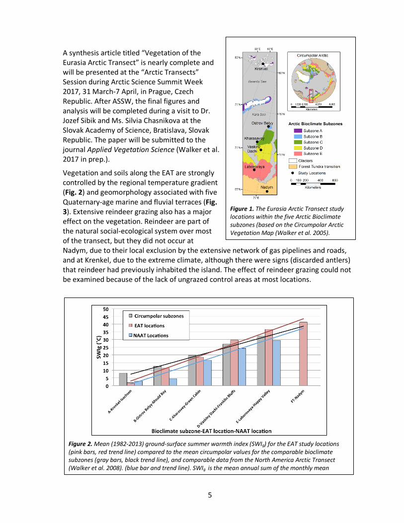
A synthesis article titled “Vegetation of the Eurasia Arctic Transect” is nearly complete and will be presented at the “Arctic Transects” Session during Arctic Science Summit Week 2017, 31 March-7 April, in Prague, Czech Republic. After ASSW, the final figures and analysis will be completed during a visit to Dr. Jozef Sibik and Ms. Silvia Chasnikova at the Slovak Academy of Science, Bratislava, Slovak Republic. The paper will be submitted to the journal Applied Vegetation Science (Walker et al. 2017 in prep.).
Vegetation and soils along the EAT are strongly controlled by the regional temperature gradient (Fig. 2) and geomorphology associated with five Quaternary-age marine and fluvial terraces (Fig. 3). Extensive reindeer grazing also has a major effect on the vegetation. Reindeer are part of the natural social-ecological system over most of the transect, but they did not occur at Nadym, due to their local exclusion by the extensive network of gas pipelines and roads, and at Krenkel, due to the extreme climate, although there were signs (discarded antlers) that reindeer had previously inhabited the island. The effect of reindeer grazing could not be examined because of the lack of ungrazed control areas at most locations.
Figure 1. The Eurasia Arctic Transect study locations within the five Arctic Bioclimate subzones (based on the Circumpolar Arctic Vegetation Map (Walker et al. 2005).
Figure 2. Mean (1982-2013) ground-surface summer warmth index (SWIg) for the EAT study locations (pink bars, red trend line) compared to the mean circumpolar values for the comparable bioclimate subzones (gray bars, black trend line), and comparable data from the North America Arctic Transect (Walker et al. 2008). (blue bar and trend line). SWIg is the mean annual sum of the monthly mean temperature >0 ˚C, determined from AVHRR statellite thermal bands (Raynolds et al. 2008).
6
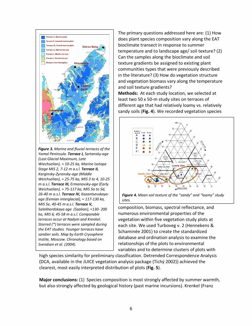
The primary questions addressed here are: (1) How does plant species composition vary along the EAT bioclimate transect in response to summer temperature and to landscape age/ soil texture? (2) Can the samples along the bioclimate and soil texture gradients be assigned to existing plant communities types that were previously described in the literature? (3) How do vegetation structure and vegetation biomass vary along the temperature and soil texture gradients? Methods: At each study location, we selected at least two 50 x 50-m study sites on terraces of different age that had relatively loamy vs. relatively sandy soils (Fig. 4). We recorded vegetation species
composition, biomass, spectral reflectance, and numerous environmental properties of the vegetation within five vegetation study plots at each site. We used Turboveg v. 2 (Hennekens & Schaminée 2001) to create the standardized database and ordination analysis to examine the relationships of the plots to environmental variables and to determine clusters of plots with
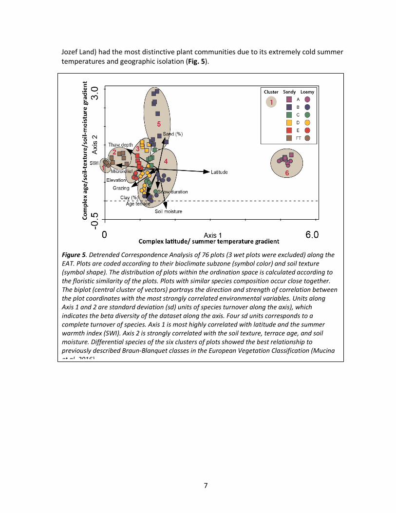
high species similarity for preliminary classification. Detrended Correspondence Analysis (DCA, available in the JUICE vegetation analysis package (Tichý 2002)) achieved the clearest, most easily interpreted distribution of plots (Fig. 5). Major conclusions: (1) Species composition is most strongly affected by summer warmth, but also strongly affected by geological history (past marine incursions). Krenkel (Franz
Figure 3. Marine and fluvial terraces of the Yamal Peninsula. Terrace I, Sartansky-age (Last Glacial Maximum, Late Wiechselian), ≈ 10-25 ka, Marine Isotope Stage MIS 2, 7-12 m a.s.l. Terrace II, Karginsky-Zyransky-age (Middle Weichselian), ≈ 25-75 ka, MIS 3 to 4, 10-25 m a.s.l. Terrace III, Ermanovsky-age (Early Weichselian), ≈ 75-117 ka, MIS 5a to 5d, 26-40 m a.s.l. Terrace IV, Kazantsevskaya-age (Eemian interglacial), ≈ 117-130 ka, MIS 5e, 40-45 m a.s.l. Terrace V, Salekhardskaya age (Saalian), ≈130- 200 ka, MIS 6, 45-58 m a.s.l. Comparable terraces occur at Nadym and Krenkel. Starred (*) terraces were sampled during the EAT studies. Younger terraces have sandier soils. Map by Earth Cryosphere Instite, Moscow. Chronology based on Svendsen et al. (2004).
Figure 4. Mean soil texture of the “sandy” and “loamy” study sites.
7
Jozef Land) had the most distinctive plant communities due to its extremely cold summer temperatures and geographic isolation (Fig. 5).
Figure 5. Detrended Correspondence Analysis of 76 plots (3 wet plots were excluded) along the EAT. Plots are coded according to their bioclimate subzone (symbol color) and soil texture (symbol shape). The distribution of plots within the ordination space is calculated according to the floristic similarity of the plots. Plots with similar species composition occur close together. The biplot (central cluster of vectors) portrays the direction and strength of correlation between the plot coordinates with the most strongly correlated environmental variables. Units along Axis 1 and 2 are standard deviation (sd) units of species turnover along the axis), which indicates the beta diversity of the dataset along the axis. Four sd units corresponds to a complete turnover of species. Axis 1 is most highly correlated with latitude and the summer warmth index (SWI). Axis 2 is strongly correlated with the soil texture, terrace age, and soil moisture. Differential species of the six clusters of plots showed the best relationship to previously described Braun-Blanquet classes in the European Vegetation Classification (Mucina et al. 2016).
8
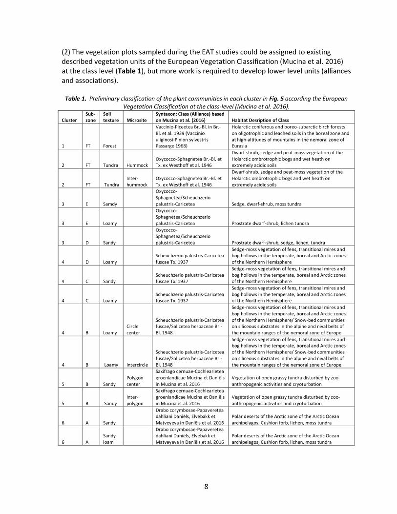
(2) The vegetation plots sampled during the EAT studies could be assigned to existing described vegetation units of the European Vegetation Classification (Mucina et al. 2016) at the class level (Table 1), but more work is required to develop lower level units (alliances and associations).
Table 1. Preliminary classification of the plant communities in each cluster in Fig. 5 according the European Vegetation Classification at the class-level (Mucina et al. 2016).
Cluster Sub-zone
Soil texture Microsite
Syntaxon: Class (Alliance) based on Mucina et al. (2016) Habitat Desription of Class
1 FT Forest
Vaccinio-Piceetea Br.-Bl. in Br.-Bl. et al. 1939 (Vaccinio uliginosi-Pinion sylvestris Passarge 1968)
Holarctic coniferous and boreo-subarctic birch forests on oligotrophic and leached soils in the boreal zone and at high-altitudes of mountains in the nemoral zone of Eurasia
2 FT Tundra Hummock Oxycocco-Sphagnetea Br.-Bl. et Tx. ex Westhoff et al. 1946
Dwarf-shrub, sedge and peat-moss vegetation of the Holarctic ombrotrophic bogs and wet heath on extremely acidic soils
2 FT Tundra Inter-hummock
Oxycocco-Sphagnetea Br.-Bl. et Tx. ex Westhoff et al. 1946
Dwarf-shrub, sedge and peat-moss vegetation of the Holarctic ombrotrophic bogs and wet heath on extremely acidic soils
3 E Samdy
Oxycocco-Sphagnetea/Scheuchzerio palustris-Caricetea Sedge, dwarf-shrub, moss tundra
3 E Loamy
Oxycocco-Sphagnetea/Scheuchzerio palustris-Caricetea Prostrate dwarf-shrub, lichen tundra
3 D Sandy
Oxycocco-Sphagnetea/Scheuchzerio palustris-Caricetea Prostrate dwarf-shrub, sedge, lichen, tundra
4 D Loamy Scheuchzerio palustris-Caricetea fuscae Tx. 1937
Sedge-moss vegetation of fens, transitional mires and bog hollows in the temperate, boreal and Arctic zones of the Northern Hemisphere
4 C Sandy Scheuchzerio palustris-Caricetea fuscae Tx. 1937
Sedge-moss vegetation of fens, transitional mires and bog hollows in the temperate, boreal and Arctic zones of the Northern Hemisphere
4 C Loamy Scheuchzerio palustris-Caricetea fuscae Tx. 1937
Sedge-moss vegetation of fens, transitional mires and bog hollows in the temperate, boreal and Arctic zones of the Northern Hemisphere
4 B Loamy Circle center
Scheuchzerio palustris-Caricetea fuscae/Salicetea herbaceae Br.-Bl. 1948
Sedge-moss vegetation of fens, transitional mires and bog hollows in the temperate, boreal and Arctic zones of the Northern Hemisphere/ Snow-bed communities on siliceous substrates in the alpine and nival belts of the mountain ranges of the nemoral zone of Europe
4 B Loamy Intercircle
Scheuchzerio palustris-Caricetea fuscae/Salicetea herbaceae Br.-Bl. 1948
Sedge-moss vegetation of fens, transitional mires and bog hollows in the temperate, boreal and Arctic zones of the Northern Hemisphere/ Snow-bed communities on siliceous substrates in the alpine and nival belts of the mountain ranges of the nemoral zone of Europe
5 B Sandy Polygon center
Saxifrago cernuae-Cochlearietea groenlandicae Mucina et Daniëls in Mucina et al. 2016
Vegetation of open grassy tundra disturbed by zoo-anthropogenic activities and cryoturbation
5 B Sandy Inter-polygon
Saxifrago cernuae-Cochlearietea groenlandicae Mucina et Daniëls in Mucina et al. 2016
Vegetation of open grassy tundra disturbed by zoo-anthropogenic activities and cryoturbation
6 A Sandy
Drabo corymbosae-Papaveretea dahliani Daniëls, Elvebakk et Matveyeva in Daniëls et al. 2016
Polar deserts of the Arctic zone of the Arctic Ocean archipelagos; Cushion forb, lichen, moss tundra
6 A Sandy loam
Drabo corymbosae-Papaveretea dahliani Daniëls, Elvebakk et Matveyeva in Daniëls et al. 2016
Polar deserts of the Arctic zone of the Arctic Ocean archipelagos; Cushion forb, lichen, moss tundra
9
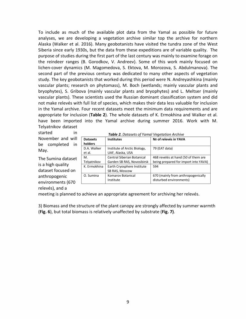
To include as much of the available plot data from the Yamal as possible for future analyses, we are developing a vegetation archive similar top the archive for northern Alaska (Walker et al. 2016). Many geobotanists have visited the tundra zone of the West Siberia since early 1930s, but the data from these expeditions are of variable quality. The purpose of studies during the first part of the last century was mainly to examine forage on the reindeer ranges (B. Gorodkov, V. Andreev). Some of this work mainly focused on lichen-cover dynamics (M. Magomedova, S. Ektova, M. Morozova, S. Abdulmanova). The second part of the previous century was dedicated to many other aspects of vegetation study. The key geobotanists that worked during this period were N. Andreyashkina (mainly vascular plants; research on phytomass), M. Boch (wetlands; mainly vascular plants and bryophytes), S. Gribova (mainly vascular plants and bryophytes) and L. Meltser (mainly vascular plants). These scientists used the Russian dominant classification system and did not make relevés with full list of species, which makes their data less valuable for inclusion in the Yamal archive. Four recent datasets meet the minimum data requirements and are appropriate for inclusion (Table 2). The whole datasets of K. Ermokhina and Walker et al. have been imported into the Yamal archive during summer 2016. Work with M. Telyatnikov dataset started in November and will be completed in May.
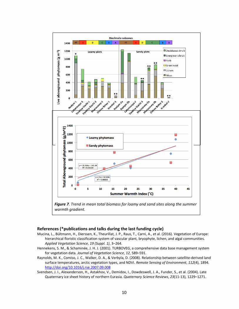
The Sumina dataset is a high quality dataset focused on anthropogenic environments (670 relevés), and a meeting is planned to achieve an appropriate agreement for archiving her relevés. 3) Biomass and the structure of the plant canopy are strongly affected by summer warmth (Fig. 6), but total biomass is relatively unaffected by substrate (Fig. 7).
Table 2. Datasets of Yamal Vegetation Archive Datasets holders
Institutes № of relevés in YAVA
D.A. Walker et al.
Institute of Arctic Biology, UAF, Alaska, USA
79 (EAT data)
M. Telyatnikov
Central Siberian Botanical Garden SB RAS, Novosibirsk
468 revelés at hand (50 of them are being prepared for import into YAVA)
K. Ermokhina Earth Cryosphere Institute SB RAS, Moscow
594
O. Sumina Komarov Botanical Institute
670 (mainly from anthropogenically disturbed environments)
10
References (*publications and talks during the last funding cycle) Mucina, L., Bültmann, H., Dierssen, K., Theurillat, J. P., Raus, T., Carni, A., et al. (2016). Vegetation of Europe:
hierarchical floristic classification system of vascular plant, bryophyte, lichen, and algal communities. Applied Vegetation Science, 19 (Suppl. 1), 3–264.
Hennekens, S. M., & Schaminée, J. H. J. (2001). TURBOVEG, a comprehensive data base management system for vegetation data. Journal of Vegetation Science, 12, 589–591.
Raynolds, M. K., Comiso, J. C., Walker, D. A., & Verbyla, D. (2008). Relationship between satellite-derived land surface temperatures, arctic vegetation types, and NDVI. Remote Sensing of Environment, 112(4), 1894. http://doi.org/10.1016/j.rse.2007.09.008
Svendsen, J. I., Alexanderson, H., Astakhov, V., Demidov, I., Dowdeswell, J. A., Funder, S., et al. (2004). Late Quaternary ice sheet history of northern Eurasia. Quaternary Science Reviews, 23(11-13), 1229–1271.
Figure 6. Mean (n=5) biomass at the EAT study sites in each bioclimate subzone grouped by loamy and sandy plots and sorted by growth form.
Figure 7. Trend in mean total biomass for loamy and sand sites along the summer warmth gradient.
11
http://doi.org/10.1016/j.quascirev.2003.12.008 Tichý, L., Holt, J., & Nejezchlebova, M. (2011). JUICE program for management, analysis and classification of
ecological data. Brno: Vegetation Science Group. Masaryk University. Walker, D. A., Raynolds, M. K., Daniëls, F. J. A., Einarsson, E., Elvebakk, A., Gould, W. A., et al. (2005). The
Circumpolar Arctic Vegetation Map. Journal of Vegetation Science, 16(3), 282. http://doi.org/10.1658/1100-9233(2005)016[0267:TCAVM]2.0.CO;2
Walker, D. A., Epstein, H. E., Romanovsky, V. E., Ping, C. L., Michaelson, G. J., Daanen, R. P., et al. (2008). Arctic patterned-ground ecosystems: A synthesis of field studies and models along a North American Arctic Transect. Journal of Geophysical Research Atmospheres, 113(G3), G03S01. http://doi.org/10.1029/2007JG000504
*Walker, D. A., Breen, A. L., Druckenmiller, L. A., Wirth, L. W., Fisher, W., Raynolds, M. K., et al. (2016). The Alaska Arctic Vegetation Archive (AVA-AK). Phytocoenologia, 46, 221–229.
*Walker, D. A., Šibík, J., Chasnikova, S., Epstein, H. E., Ermokhina, K., Frost, G. V., et al. (2017 in prep.). Vegetation on mesic loamy and sandy sites along a Eurasia Arctic bioclimate gradient, Yamal Peninsula and Franz Jozef Land, Russia. Applied Vegetation Science.
Conference abstracts *Walker, D.A. 2016. Yamal LCLUC Synthesis. NASA-LCLUC All Scientist Meeting, Bethesda, MD, 18-19 April
2016 *Walker, D. A., Epstein, H. E., Leibman, M. O., Ermokhina, K., Khomutov, A., Moskolenko, N., et al. (2016).
Eurasia Arctic Transect (Yamal Peninsula and Franz Josef Land, Russia): Relationships between climate, soil texture, vegetation, active-layer thickness, and spectral data. Presented at the 11th International Conference on Permafrost, Potsdam, Germany, - Jun, Potsdam, Germany.
12
Soils (G. Matyshak)
Introduction: Analyses of the soils data are nearly complete, based on existing descriptions (Walker, 2008, 2009, 2011) and completed soil analyzes (Walker 2011, Matyshak 2008, 2012). A paper based on the materials of this analysis will be presented during the “Arctic Transects” session of ASSW 2017.
Major conclusions: (1) Sites along the transect are characterized by the predominance of the mineral soils (Turbels). Organic soils (Histels) are widespread only in the taiga subzone (Nadym) and occasionally met at Vaskiny Dachi and Ostrov Belyy sites in the form of remnants of relict peat bogs.
(2) Cryogenic processes, including cracking, heaving and cryoturbation, determine the formation and high heterogeneity of the transect soils, resulting with well-defined microrelief features such as non-sorted circles and small nonsorted polygons.
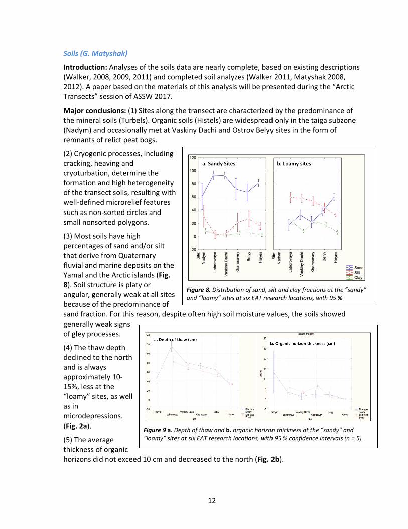
(3) Most soils have high percentages of sand and/or silt that derive from Quaternary fluvial and marine deposits on the Yamal and the Arctic islands (Fig. 8). Soil structure is platy or angular, generally weak at all sites because of the predominance of sand fraction. For this reason, despite often high soil moisture values, the soils showed generally weak signs of gley processes.
(4) The thaw depth declined to the north and is always approximately 10-15%, less at the “loamy” sites, as well as in microdepressions. (Fig. 2a).
(5) The average thickness of organic horizons did not exceed 10 cm and decreased to the north (Fig. 2b).
Figure 8. Distribution of sand, silt and clay fractions at the “sandy” and “loamy” sites at six EAT research locations, with 95 % confidence intervals (n = 5).
Figure 9 a. Depth of thaw and b. organic horizon thickness at the “sandy” and “loamy” sites at six EAT research locations, with 95 % confidence intervals (n = 5).
13
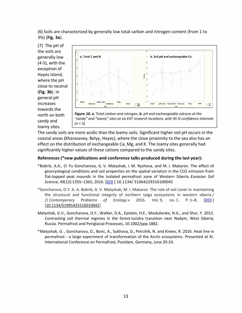
(6) Soils are characterized by generally low total carbon and nitrogen content (from 1 to 3%) (Fig. 3a).
(7) The pH of the soils are generally low (4-5), with the exception of Hayes Island, where the pH close to neutral (Fig. 3b). In general pH increases towards the north on both sandy and loamy sites. The sandy soils are more acidic than the loamy soils. Significant higher soil pH occurs in the coastal areas (Kharasavey, Belyy, Hayes), where the close proximity to the sea also has an effect on the distribution of exchangeable Ca, Mg, and K. The loamy sites generally had significantly higher values of these cations compared to the sandy sites.
References (*new publications and conference talks produced during the last year):
*Bobrik, A.A., O. Yu Goncharova, G. V. Matyshak, I. M. Ryzhova, and M. I. Makarov. The effect of geocryological conditions and soil properties on the spatial variation in the CO2 emission from flat-topped peat mounds in the isolated permafrost zone of Western Siberia. Eurasian Soil Science, 49(12):1355–1365, 2016. [DOI ] 10.1134/ S1064229316100045
*Goncharova, O.Y. A. A. Bobrik, G. V. Matyshak, M. I. Makarov The role of soil cover in maintaining the structural and functional integrity of northern taiga ecosystems in western siberia / // Contemporary Problems of Ecology.v 2016. Vol. 9, no. 1. P. 1–8. [DOI ] [10.1134/S1995425516010042]
Matyshak, G.V., Goncharova, O.Y., Walker, D.A., Epstein, H.E., Moskalenko, N.G., and Shur, Y. 2015. Contrasting soil thermal regimes in the forest-tundra transition near Nadym, West Siberia, Russia. Permafrost and Periglacial Processes, 10.1002/ppp.1882.
*Matyshak, G. , Goncharova, O., Boric, A., Sukhova, D., Petrzhik, N. and Kireev, R. 2016. Heat line in permafrost - a large experiment of transformation of the Arctic ecosystems. Presented at XI. International Conference on Permafrost, Postdam, Germany, June 20-24.
Figure 10. a. Total carbon and nitrogen, b. pH and exchangeable calcium at the “sandy” and “loamy” sites at six EAT research locations, with 95 % confidence intervals (n = 5).
14
Permafrost and active layer characterization (M.O. Leibman, A. Khumotov & V.E. Romanovsky)
Introduction: This report contains progress to date on synthesis Task 1.1 regarding permafrost, active layer and permafrost temperatures, as well as weather station data along the EAT. Out of the six key EAT sites, two (Kharasavey and Krenkel) were visited only once and field data were collected in 2008 and 2010, respectively. Key sites Laborovaya and Ostrov Belyy were visited several times since 2007 and 2009, respectively. Key areas linked to Research Stations Nadym and Vaskiny Dachi have long-term records of field data since 1978 and 1989, respectively. Active-layer grids were added at those sites to follow specific EAT protocol.
Methods: Climate data were downloaded from <https://rp5.ru/Weather_in_Yamalo-Nenets_Autonomous_Okrug> (Salekhard, Marre-Sale, Popov, and Krenkel weather stations forming a latitudinal gradient). Data were accumulated in Excel tables with calculated diurnal, month and annual averages, and diagrams along the climate gradient.
Active-layer measurements were assembled into Excel tables containing averages for a plot and a year, maximums, minimums, standard deviation, and diagrams along the climate gradient. The depth of thaw was measured along the 50-m transects arranged within the 50 x 50-m plots located in homogenous landscapes with loamy and sandy soils. At Nadym, in addition to the existing CALM grid, a 50 x 50-m plots was established in the forest. In Vaskiny Dachi in addition to existing CALM grid, three more grids were established on marine and fluvial terraces II, III, and IV (see Fig. 3). After the termination of the NASA-Funded portion of the field-based component of the project in 2010, measurements were continued within the active research stations in Nadym, Vaskiny Dachi, Ostrov Belyy and occasionally in Laborovaya. These data along with climate data are added to the spreadsheets annually and so far contain extensions until 2016.
I-buttons (small temperature data recorders) were installed at the soil surface and at the bottom of the organic layer at each vegetation plot to determine the n-factor of the soils, which is an index of the insulative properties of the organic layer. The data recorders installed during the year of field study and collected as soon as it was possible to get to the plots. They have not yet been retrieved from Kharasavey and Hayes Island. Existing data were assembled in spreadsheet, calculated and summer and winter n-factors were plotted.
Shallow boreholes were drilled and equipped with loggers at each site. Data were downloaded each year of visit at Vaskiny Dachi and Nadym. Boreholes on Bely Island were destroyed the first winter but re-drilled recently. Borehole data are collected in both spreadsheets and on diagrams.
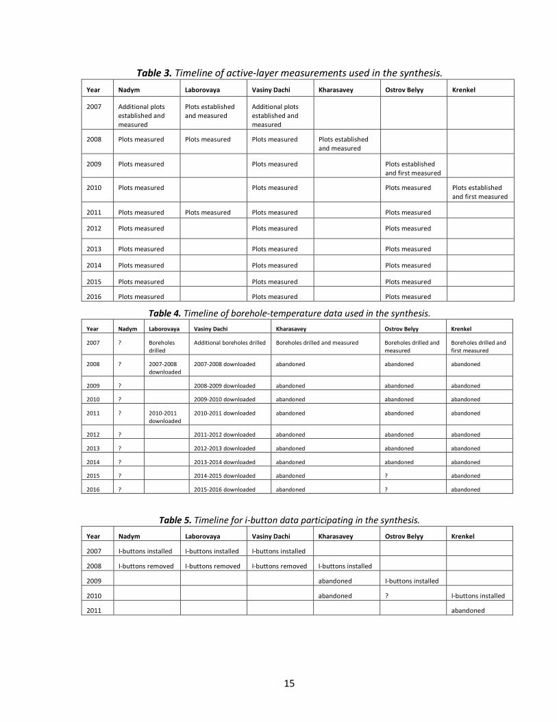
Progress: Timelines for measurements of thaw depth, borehole temperatures, and i-button for all sites along the EAT are presented in Tables 3 to 5. Active layer, ground- and air-temperatures were analyzed to understand relation of these parameters to longitudinal gradient as well as local features, such as vegetation and soil texture within the active layer.
15
Table 3. Timeline of active-layer measurements used in the synthesis. Year Nadym Laborovaya Vasiny Dachi Kharasavey Ostrov Belyy Krenkel
2007 Additional plots established and measured
Plots established and measured
Additional plots established and measured
2008 Plots measured Plots measured Plots measured Plots established and measured
2009 Plots measured Plots measured Plots established and first measured
2010 Plots measured Plots measured Plots measured Plots established and first measured
2011 Plots measured Plots measured Plots measured Plots measured
2012 Plots measured Plots measured Plots measured
2013 Plots measured Plots measured Plots measured
2014 Plots measured Plots measured Plots measured
2015 Plots measured Plots measured Plots measured
2016 Plots measured Plots measured Plots measured
Table 4. Timeline of borehole-temperature data used in the synthesis. Year Nadym Laborovaya Vasiny Dachi Kharasavey Ostrov Belyy Krenkel
2007 ? Boreholes drilled
Additional boreholes drilled Boreholes drilled and measured Boreholes drilled and measured
Boreholes drilled and first measured
2008 ? 2007-2008 downloaded
2007-2008 downloaded abandoned abandoned abandoned
2009 ? 2008-2009 downloaded abandoned abandoned abandoned
2010 ? 2009-2010 downloaded abandoned abandoned abandoned
2011 ? 2010-2011 downloaded
2010-2011 downloaded abandoned abandoned abandoned
2012 ? 2011-2012 downloaded abandoned abandoned abandoned
2013 ? 2012-2013 downloaded abandoned abandoned abandoned
2014 ? 2013-2014 downloaded abandoned abandoned abandoned
2015 ? 2014-2015 downloaded abandoned ? abandoned
2016 ? 2015-2016 downloaded abandoned ? abandoned
Table 5. Timeline for i-button data participating in the synthesis. Year Nadym Laborovaya Vasiny Dachi Kharasavey Ostrov Belyy Krenkel
2007 I-buttons installed I-buttons installed I-buttons installed
2008 I-buttons removed I-buttons removed I-buttons removed I-buttons installed
2009 abandoned I-buttons installed
2010 abandoned ? I-buttons installed
2011 abandoned
16
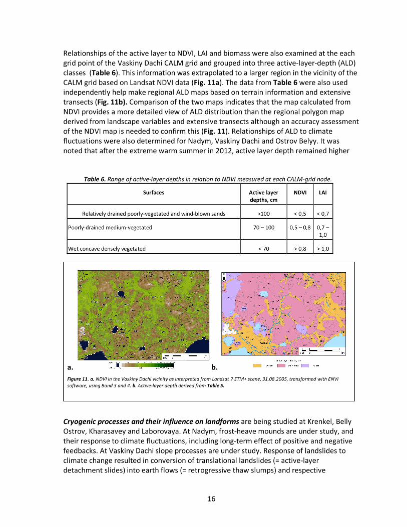
Relationships of the active layer to NDVI, LAI and biomass were also examined at the each grid point of the Vaskiny Dachi CALM grid and grouped into three active-layer-depth (ALD) classes (Table 6). This information was extrapolated to a larger region in the vicinity of the CALM grid based on Landsat NDVI data (Fig. 11a). The data from Table 6 were also used independently help make regional ALD maps based on terrain information and extensive transects (Fig. 11b). Comparison of the two maps indicates that the map calculated from NDVI provides a more detailed view of ALD distribution than the regional polygon map derived from landscape variables and extensive transects although an accuracy assessment of the NDVI map is needed to confirm this (Fig. 11). Relationships of ALD to climate fluctuations were also determined for Nadym, Vaskiny Dachi and Ostrov Belyy. It was noted that after the extreme warm summer in 2012, active layer depth remained higher
Cryogenic processes and their influence on landforms are being studied at Krenkel, Belly Ostrov, Kharasavey and Laborovaya. At Nadym, frost-heave mounds are under study, and their response to climate fluctuations, including long-term effect of positive and negative feedbacks. At Vaskiny Dachi slope processes are under study. Response of landslides to climate change resulted in conversion of translational landslides (= active-layer detachment slides) into earth flows (= retrogressive thaw slumps) and respective
a. b. Figure 11. a. NDVI in the Vaskiny Dachi vicinity as interpreted from Landsat 7 ETM+ scene, 31.08.2005, transformed with ENVI software, using Band 3 and 4. b. Active-layer depth derived from Table 5.
Table 6. Range of active-layer depths in relation to NDVI measured at each CALM-grid node.
Surfaces Active layer depths, cm
NDVI LAI
Relatively drained poorly-vegetated and wind-blown sands >100 < 0,5 < 0,7
Poorly-drained medium-vegetated 70 – 100 0,5 – 0,8 0,7 – 1,0
Wet concave densely vegetated < 70 > 0,8 > 1,0
17
landforms – thermocirques. Gas emission craters are newly discovered features that are under intensive study, and now considered a priority for future research.
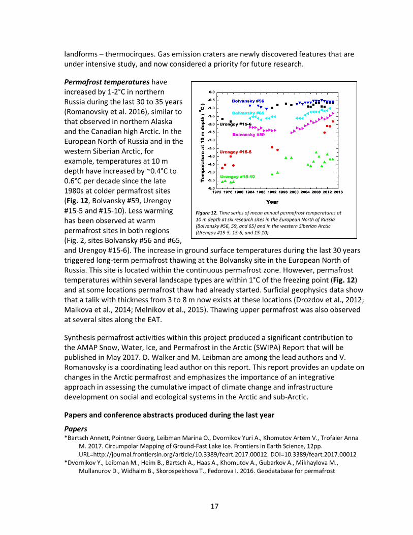
Permafrost temperatures have increased by 1-2°C in northern Russia during the last 30 to 35 years (Romanovsky et al. 2016), similar to that observed in northern Alaska and the Canadian high Arctic. In the European North of Russia and in the western Siberian Arctic, for example, temperatures at 10 m depth have increased by ~0.4°C to 0.6°C per decade since the late 1980s at colder permafrost sites (Fig. 12, Bolvansky #59, Urengoy #15-5 and #15-10). Less warming has been observed at warm permafrost sites in both regions (Fig. 2, sites Bolvansky #56 and #65, and Urengoy #15-6). The increase in ground surface temperatures during the last 30 years triggered long-term permafrost thawing at the Bolvansky site in the European North of Russia. This site is located within the continuous permafrost zone. However, permafrost temperatures within several landscape types are within 1°C of the freezing point (Fig. 12) and at some locations permafrost thaw had already started. Surficial geophysics data show that a talik with thickness from 3 to 8 m now exists at these locations (Drozdov et al., 2012; Malkova et al., 2014; Melnikov et al., 2015). Thawing upper permafrost was also observed at several sites along the EAT.
Synthesis permafrost activities within this project produced a significant contribution to the AMAP Snow, Water, Ice, and Permafrost in the Arctic (SWIPA) Report that will be published in May 2017. D. Walker and M. Leibman are among the lead authors and V. Romanovsky is a coordinating lead author on this report. This report provides an update on changes in the Arctic permafrost and emphasizes the importance of an integrative approach in assessing the cumulative impact of climate change and infrastructure development on social and ecological systems in the Arctic and sub-Arctic.
Papers and conference abstracts produced during the last year
Papers *Bartsch Annett, Pointner Georg, Leibman Marina O., Dvornikov Yuri A., Khomutov Artem V., Trofaier Anna
M. 2017. Circumpolar Mapping of Ground-Fast Lake Ice. Frontiers in Earth Science, 12pp. URL=http://journal.frontiersin.org/article/10.3389/feart.2017.00012. DOI=10.3389/feart.2017.00012
*Dvornikov Y., Leibman M., Heim B., Bartsch A., Haas A., Khomutov A., Gubarkov A., Mikhaylova M., Mullanurov D., Widhalm B., Skorospekhova T., Fedorova I. 2016. Geodatabase for permafrost
Figure 12. Time series of mean annual permafrost temperatures at 10 m depth at six research sites in the European North of Russia (Bolvansky #56, 59, and 65) and in the western Siberian Arctic (Urengoy #15-5, 15-6, and 15-10).
18
monitoring (research station Vaskiny Dachi, Yamal, Western Siberia) // Polarforschung 85 (2), 107–115, 2015
*Dvornikov Y., Leibman M., Heim B., Bartsch A., Herzschuh U., Khomutov A., Widhalm B., Skorospekhova T., Mikaylova M. 2016. Colored dissolved organic matter in thermokarst lakes of Yamal peninsula: sources, annual variations and connection to lake and catchment properties // Günther, F. and Morgenstern, A. (Eds.) (2016): XI. International Conference On Permafrost – Book of Abstracts, 20 – 24 June 2016, Potsdam, Germany. Bibliothek Wissenschaftspark Albert Einstein, doi:10.2312/GFZ.LIS.2016.001, P. 887.
*Dvornikov, Yury; Heim, Birgit; Roessler, Sebastian; Leibman, Marina O; Khomutov, Artem; Bartsch, Annett (2016): Colored dissolved organic matter (cDOM) absorption measurements in the Vaskiny Dachi region, Central Yamal, Russia. Institute of the Earth Cryosphere of the Siberian Branch of the RAS, Tyumen, doi:10.1594/PANGAEA.860049 https://doi.pangaea.de/10.1594/PANGAEA.860049
*Grosse, G., Goetz, S., McGuire, A., Romanovsky, V., and E. Schuur. 2016. Review and Synthesis: Changing Permafrost in a Warming World and Feedbacks to the Earth System, Environmental Research Letters, 11(4), 040201, http://dx.doi.org/10.1088/1748-9326/11/4/040201, 2016
*Khomutov A.V., Gubarkov A.A., Dvornikov Yu.A., Leibman M.O., Polukhin A.N., Khairullin R.R. 2016. Activation of cryogenic processes on Central Yamal under climatic fluctuations and technogenesis. Proceedings of the Fifth Russian Conference on Geocryology, Lomonosov Moscow State University 14-17 June 2016, University Books Publisher, II: 255-259 (Хомутов А.В., Губарьков А.А., Дворников Ю.А., Лейбман М.О., Муллануров Д.Р., Полухин А.Н., Хайруллин Р.Р. Активизация криогенных процессов на Центральном Ямале под воздействием климатических изменений и техногенеза // Матер. Пятой конференции геокриологов России. МГУ им. М.В. Ломоносова, 14-17 июня 2016г, Т.2, - М.: «Университетская книга», 2016. C.255-259).
*Khomutov A.V., Leibman M.O. 2016. Rating of cryogenic translational landsliding hazard in tundra of Central Yamal. Earth Cryosphere, XX (2):49-60 (Хомутов А.В., Лейбман М.О. Оценка опасности проявления криогенных оползней скольжения в тундре Центрального Ямала // Криосфера Земли, Т.XX, №2, 2016, С. 49–60).
*Khomutov A.V., Leibman M.O., Gubarkov A.A., Dvornikov Yu,A., Mullanurov D.R., Babkin E.M., Babkina E.A. 2016. Monitoring of cryolithozone: new data in Central Yamal and organizing monitoring on Gydan. Scientific Bulletin of YaNAO, 4(93): 17-19 (Хомутов А.В., Лейбман М.О., Губарьков А.А., Дворников Ю.А., Муллануров Д.Р., Бабкин Е.М., Бабкина Е.А. Мониторинг криолитозоны: новые данные на Центральном Ямале и организация наблюдений на Гыдане // Научный вестник ЯНАО, №4 (93), 2016, С. 17-19).
*Kizyakov A.I., Leibman M.O. 2016. Cryogenic relief-formation processes: a review of 2010–2015 publications. Earth Cryosphere, XX (4):45-58, DOI: 10.21782/KZ1560-7496-2016-4(45-58) (Кизяков А.И., Лейбман М.О. Рельефообразующие криогенные процессы: обзор литературы за 2010–2015 годы // Криосфера Земли, Т.XX, №4, 2016, С. 45–58).
*Leibman M.O., Kizyakov A.I. 2016. A new natural phenomenon in permafrost zone. Priroda (Nature), 2:15-24 (Лейбман М.О., Кизяков А.И. Новый природный феномен в зоне вечной мерзлоты // Природа, №2, 2016, С. 15–24).
*Lewkowicz, A., S. Weege, B. Biskaborn, D. Streletskiy, V.E. Romanovsky, and R. Fortier, Report from the International Permafrost Association, Permafrost and Periglacial Processes, DOI:10.1002/ppp.1894, 2016.
*Liljedahl, A. K., J. Boike, R. P. Daanen, A. N. Fedorov, G. V. Frost, G. Grosse, Y. Iijma, J. C. Jorgenson, N. Matveyeva, M. Necsoiu, M. K. Raynolds, V. E. Romanovsky, J Schulla, K. Tape, D. A. Walker, H. Yabuki, Recent circum-Arctic ice wedge degradation with major hydrologic impacts, Nature Geoscience, DOI: 10.1038/NGEO2674, 2016.
*Olefeldt D., Goswami S., Grosse G., Hayes D., Hugelius G., Kuhry P., McGuire A.D., Romanovsky V.E., Sannel A.B.K., Schuur E.A.G., and Turetsky M.R., Thermokarst terrain: circumpolar distribution and soil carbon vulnerability, Nature Climate Change, 7:13043, DOI: 10.1038/ncomms13043, www.nature.com/naturecommunications, 2016.
*Romanovsky, V. E., S. L. Smith, K. Isaksen, N. I. Shiklomanov, D. A. Streletskiy, A. L. Kholodov, H. H. Christiansen, D. S. Drozdov, G. V. Malkova, and S. S. Marchenko, 2016: [The Arctic] Terrestrial Permafrost [in “State of the Climate in 2015”]. Bull. Amer. Meteor. Soc., Vol. 97, No. 8, S149-S152, 2016.
19
*Widhalm, B., Bartsch, A., Leibman, M., and Khomutov, A.: Active-layer thickness estimation from X-band SAR backscatter intensity, The Cryosphere, 11, 483-496, doi:10.5194/tc-11-483-2017, 2017.
Conference abstracts *Dvornikov Yu.A., Leibman M.O., Khomutov A.V. 2016. Origin of the Yamal lakes. Abstracts of the Conference
“Thematic and interdisciplinary research in the Arctic and Antarctic”, 3-5 October 2016, Sochi: 30 (Дворников Ю.А., Лейбман М.О., Хомутов А.В. Происхождение озер Ямала // Тезисы конференции «ТЕМАТИЧЕСКИЕ И МЕЖДИСЦИПЛИНАРНЫЕ ИССЛЕДОВАНИЯ В АРКТИКЕ И АНТАРКТИКЕ». 3–5 октября 2016 г., Сочи, 2016, С. 30).
*Ermokhina K., Kizyakov A., Leibman M., Khomutov A. 2016. GIS of the gas-emission crater area (Yamal peninsula, Russia) // Günther, F. and Morgenstern, A. (Eds.) (2016): XI. International Conference On Permafrost – Book of Abstracts, 20 – 24 June 2016, Potsdam, Germany. Bibliothek Wissenschaftspark Albert Einstein, doi:10.2312/GFZ.LIS.2016.001, P. 972–973.
*Khomutov A., Dvornikov Y., Leibman M., Gubarkov A., Mullanurov D. 2016. The rates of thermocirque development and driving factors of their activation on Central Yamal, Russia // Günther, F. and Morgenstern, A. (Eds.) (2016): XI. International Conference On Permafrost – Book of Abstracts, 20 – 24 June 2016, Potsdam, Germany. Bibliothek Wissenschaftspark Albert Einstein, doi:10.2312/GFZ.LIS.2016.001, P. 898–899.
*Khomutov A., Leibman M., Dvornikov Y., Khitun O. 2016. Study of off-road vehicle trails impact on tundra landscapes by field and remote-sensing methods, Central Yamal, Russia // Günther, F. and Morgenstern, A. (Eds.) (2016): XI. International Conference On Permafrost – Book of Abstracts, 20 – 24 June 2016, Potsdam, Germany. Bibliothek Wissenschaftspark Albert Einstein, doi:10.2312/GFZ.LIS.2016.001, P. 900–901.
*Khomutov A.V., Arefiev S.P., Dvornikov Yu.A., Ermokhina K.A., Kizyakov A.I., Leibman M.O., Khairullin R.R. 2016. History of the gas-emission crater in Yamal: geomorphic, geobotany, dendrochronology aspects. Abstracts of the Conference “Thematic and interdisciplinary research in the Arctic and Antarctic”, 3-5 October 2016, Sochi: 39 (Хомутов А.В., Арефьев С.П., Дворников Ю.А., Ермохина К.А., Кизяков А.И., Лейбман М.О., Хайруллин Р.Р. История возникновения воронки газового выброса на Ямале: геоморфологические, геоботанические, дендрохронологические аспекты // Тезисы конференции «ТЕМАТИЧЕСКИЕ И МЕЖДИСЦИПЛИНАРНЫЕ ИССЛЕДОВАНИЯ В АРКТИКЕ И АНТАРКТИКЕ». 3–5 октября 2016 г., Сочи, 2016, С. 39).
*Kizyakov A., Leibman M., Sonyushkin A., Zimin M., Khomutov A. 2016. Gas-emission crater, geomorphological characteristics and relief dynamics on Yamal Peninsula, Russia // Günther, F. and Morgenstern, A. (Eds.) (2016): XI. International Conference On Permafrost – Book of Abstracts, 20 – 24 June 2016, Potsdam, Germany. Bibliothek Wissenschaftspark Albert Einstein, doi:10.2312/GFZ.LIS.2016.001, P. 987–988.
*Leibman M., Kizyakov A., Streletskaya I., Khomutov A., Dvornikov Y., Ermokhina K., Gubarkov A. 2016. Complex study of gas-emission crater in Central Yamal, Russia // Günther, F. and Morgenstern, A. (Eds.) (2016): XI. International Conference On Permafrost – Book of Abstracts, 20 – 24 June 2016, Potsdam, Germany. Bibliothek Wissenschaftspark Albert Einstein, doi:10.2312/GFZ.LIS.2016.001, P. 989–990.
*Leibman M.O., Kizyakov A.I., Streletskaya I.D., Khomutov A.V., Dvornikov Yu.A., Ermokhina K.A., Gubarkov A.A., Arefiev S.P. 2016. Results of the complex study of the gas-emission crater in Central Yamal. Abstracts of the Conference “Thematic and interdisciplinary research in the Arctic and Antarctic”, 3-5 October 2016, Sochi: 32 (Лейбман М.О., Кизяков A.И., Стрелецкая И.Д., Хомутов А.В., Дворников Ю.А., Ермохина К.А., Губарьков А.А., Арефьев С.П. Результаты комплексных исследований воронки газового выброса на центральном Ямале // Тезисы конференции «ТЕМАТИЧЕСКИЕ И МЕЖДИСЦИПЛИНАРНЫЕ ИССЛЕДОВАНИЯ В АРКТИКЕ И АНТАРКТИКЕ». 3–5 октября 2016 г., Сочи, 2016, С. 32).
*Noerling C., Morgenstern A., Leibman M., Bartsch A., Widhalm B., Dvornikov Y., Khomutov A., Heim B. 2016. Short time changes of permafrost degradation triggered by anthropogenic impact and climatic events in Yamal Peninsula, Western Siberia 2010 - 2013/2015 // Günther, F. and Morgenstern, A. (Eds.) (2016): XI. International Conference On Permafrost – Book of Abstracts, 20 – 24 June 2016, Potsdam, Germany. Bibliothek Wissenschaftspark Albert Einstein, doi:10.2312/GFZ.LIS.2016.001, P. 75.
20
*Polukhin A., Dvornikov Y., Khomutov A., Leibman M., Mullanurov D., Perednya D. 2016. Analysis of ground temperature and active layer thickness monitoring results in relation to a number of climatic controls at Vaskiny Dachi research station, Yamal, Russia // Günther, F. and Morgenstern, A. (Eds.) (2016): XI. International Conference On Permafrost – Book of Abstracts, 20 – 24 June 2016, Potsdam, Germany. Bibliothek Wissenschaftspark Albert Einstein, doi:10.2312/GFZ.LIS.2016.001, P. 469–471.
*Walker D., Epstein H., Leibman M., Ermokhina K., Khomutov A., Moskalenko N., Orekhov P., Matyshak G., Frost G., Khitun O., Chasnikova S., Sibik J., Kaarlejarvi E., Kuss J. 2016. Eurasia Arctic Transect (Yamal Peninsula and Franz Josef Land, Russia): Relationships between climate, soil texture, vegetation, active-layer thickness, and spectral data // Günther, F. and Morgenstern, A. (Eds.) (2016): XI. International Conference On Permafrost – Book of Abstracts, 20 – 24 June 2016, Potsdam, Germany. Bibliothek Wissenschaftspark Albert Einstein, doi:10.2312/GFZ.LIS.2016.001, P. 920–921.
*Walker D., Peirce J., Kumpula T., Leibman M., Matyshak G., Streltskiy D., Raynolds M., Shur Y., Kanevskiy M., Buchhorn M., Kofinas G., Ambrosius K., Epstein H., Romanovsky V., Forbes B., Khomutov A., Khitun O., Shiklomanov N., Grebenets V., Lemay M., Allard M., Vincent W., Lamoreux S., Bell T., Forbes D., Fondahl G., Kuznetsova E., Roy L.-P., Petrov A., Schweitzer P. 2016. Rapid Arctic Transitions due to Infrastructure and Climate (RATIC): An ICARP III initiative focusing on the cumulative effects of Arctic infrastructure and climate change // Günther, F. and Morgenstern, A. (Eds.) (2016): XI. International Conference On Permafrost – Book of Abstracts, 20 – 24 June 2016, Potsdam, Germany. Bibliothek Wissenschaftspark Albert Einstein, doi:10.2312/GFZ.LIS.2016.001, P. 1221–1223.
*Widhalm B., Bartsch A., Leibman M5.., Dvornikov Y., Heim B. 2016. Combining remote sensing and field studies for assessment of landform dynamics and permafrost state on Yamal // Günther, F. and Morgenstern, A. (Eds.) (2016): XI. International Conference On Permafrost – Book of Abstracts, 20 – 24 June 2016, Potsdam, Germany. Bibliothek Wissenschaftspark Albert Einstein, doi:10.2312/GFZ.LIS.2016.001, P. 92
Spectral reflectance characteristics of the EAT (Epstein and Frost)
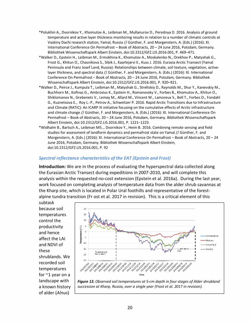
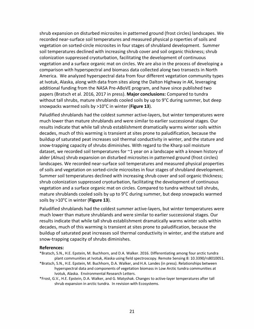
Introduction: We are in the process of evaluating the hyperspectral data collected along the Eurasian Arctic Transect during expeditions in 2007-2010, and will complete this analysis within the requested no-cost extension (Epstein et al. 2016a). During the last year, work focused on completing analysis of temperature data from the alder shrub savannas at the Kharp site, which is located in Polar Ural foothills and representative of the forest-alpine tundra transition (Fr ost et al. 2017 in revision). This is a critical element of this subtask because soil temperatures control the productivity and hence affect the LAI and NDVI of these shrublands. We recorded soil temperatures for ~1 year on a landscape with a known history of alder (Alnus)
Figure 13. Observed soil temperatures at 5-cm depth in four stages of Alder shrubland succession at Kharp, Russia, over a single year (Frost et al. 2017 in revision).
21
shrub expansion on disturbed microsites in patterned ground (frost circles) landscapes. We recorded near-surface soil temperatures and measured physical p roperties of soils and vegetation on sorted-circle microsites in four stages of shrubland development. Summer soil temperatures declined with increasing shrub cover and soil organic thickness; shrub colonization suppressed cryoturbation, facilitating the development of continuous vegetation and a surface organic mat on circles. We are also in the process of developing a comparison with hyperspectral and biomass data collected along two transects in North America. We analyzed hyperspectral data from four different vegetation community types at Ivotuk, Alaska, along with data from sites along the Dalton Highway in AK, leveraging additional funding from the NASA Pre-ABoVE program, and have since published two papers (Bratsch et al. 2016, 2017 in press). Major conclusions: Compared to tundra without tall shrubs, mature shrublands cooled soils by up to 9°C during summer, but deep snowpacks warmed soils by >10°C in winter (Figure 13).
Paludified shrublands had the coldest summer active-layers, but winter temperatures were much lower than mature shrublands and were similar to earlier successional stages. Our results indicate that while tall shrub establishment dramatically warms winter soils within decades, much of this warming is transient at sites prone to paludification, because the buildup of saturated peat increases soil thermal conductivity in winter, and the stature and snow-trapping capacity of shrubs diminishes. With regard to the Kharp soil moisture dataset, we recorded soil temperatures for ~1 year on a landscape with a known history of alder (Alnus) shrub expansion on disturbed microsites in patterned ground (frost circles) landscapes. We recorded near-surface soil temperatures and measured physical properties of soils and vegetation on sorted-circle microsites in four stages of shrubland development. Summer soil temperatures declined with increasing shrub cover and soil organic thickness; shrub colonization suppressed cryoturbation, facilitating the development of continuous vegetation and a surface organic mat on circles. Compared to tundra without tall shrubs, mature shrublands cooled soils by up to 9°C during summer, but deep snowpacks warmed soils by >10°C in winter (Figure 13).
Paludified shrublands had the coldest summer active-layers, but winter temperatures were much lower than mature shrublands and were similar to earlier successional stages. Our results indicate that while tall shrub establishment dramatically warms winter soils within decades, much of this warming is transient at sites prone to paludification, because the buildup of saturated peat increases soil thermal conductivity in winter, and the stature and snow-trapping capacity of shrubs diminishes.
References: *Bratsch, S.N., H.E. Epstein, M. Buchhorn, and D.A. Walker. 2016. Differentiating among four arctic tundra
plant communities at Ivotuk, Alaska using field spectroscopy. Remote Sensing 8: 10.3390/rs8010051. *Bratsch, S.N., H.E. Epstein, M. Buchhorn, D.A. Walker, and H.A. Landes (in press). Relationships between
hyperspectral data and components of vegetation biomass in Low Arctic tundra communities at Ivotuk, Alaska. Environmental Research Letters.
*Frost, G.V., H.E. Epstein, D.A. Walker, and G. Matyshak. Changes to active-layer temperatures after tall shrub expansion in arctic tundra. In revision with Ecosystems.
22
Seasonal dynamics and long-term trends of land temperatures and NDVI along the EAT and North America Arctic Transects (Bhatt and Epstein)
Introduction: Previous studies have shown that the trends in land temperatures and NDVI are related to the trend in Arctic sea-ice cover (Bhatt et al. 2010). Continued monitoring of the circumpolar trends in sea-ice cover, sea-surface temperature, land-surface temperature, and NDVI resulted in two new publications during the past year (Bhatt et al. 2016a, Epstein 2016a), and presentations at three conferences (Bhatt et al. 2016b, c; Epstein et al. 2016b).
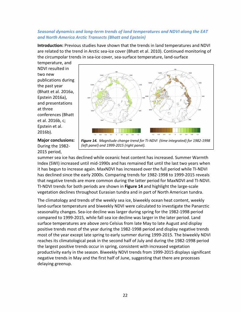
Major conclusions: During the 1982-2015 period, summer sea ice has declined while oceanic heat content has increased. Summer Warmth Index (SWI) increased until mid-1990s and has remained flat until the last two years when it has begun to increase again. MaxNDVI has increased over the full period while TI-NDVI has declined since the early 2000s. Comparing trends for 1982-1998 to 1999-2015 reveals that negative trends are more common during the latter period for MaxNDVI and TI-NDVI. TI-NDVI trends for both periods are shown in Figure 14 and highlight the large-scale vegetation declines throughout Eurasian tundra and in part of North American tundra.
The climatology and trends of the weekly sea ice, biweekly ocean heat content, weekly land-surface temperature and biweekly NDVI were calculated to investigate the Panarctic seasonality changes. Sea-ice decline was larger during spring for the 1982-1998 period compared to 1999-2015, while fall sea ice decline was larger in the later period. Land surface temperatures are above zero Celsius from late May to late August and display positive trends most of the year during the 1982-1998 period and display negative trends most of the year except late spring to early summer during 1999-2015. The biweekly NDVI reaches its climatological peak in the second half of July and during the 1982-1998 period the largest positive trends occur in spring, consistent with increased vegetation productivity early in the season. Biweekly NDVI trends from 1999-2015 displays significant negative trends in May and the first half of June, suggesting that there are processes delaying greenup.
Figure 14. Magnitude change trend for TI-NDVI (time integrated) for 1982-1998 (left panel) and 1999-2015 (right panel).
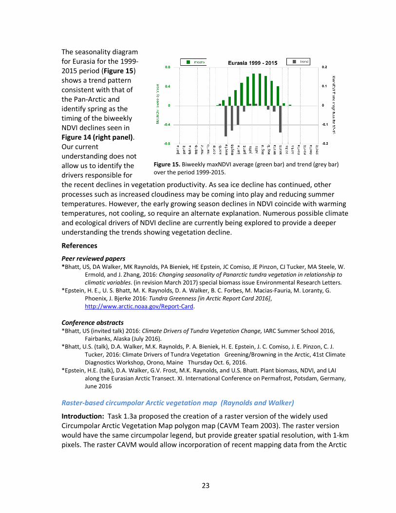
23
The seasonality diagram for Eurasia for the 1999-2015 period (Figure 15) shows a trend pattern consistent with that of the Pan-Arctic and identify spring as the timing of the biweekly NDVI declines seen in Figure 14 (right panel). Our current understanding does not allow us to identify the drivers responsible for the recent declines in vegetation productivity. As sea ice decline has continued, other processes such as increased cloudiness may be coming into play and reducing summer temperatures. However, the early growing season declines in NDVI coincide with warming temperatures, not cooling, so require an alternate explanation. Numerous possible climate and ecological drivers of NDVI decline are currently being explored to provide a deeper understanding the trends showing vegetation decline.
References
Peer reviewed papers *Bhatt, US, DA Walker, MK Raynolds, PA Bieniek, HE Epstein, JC Comiso, JE Pinzon, CJ Tucker, MA Steele, W.
Ermold, and J. Zhang, 2016: Changing seasonality of Panarctic tundra vegetation in relationship to climatic variables. (in revision March 2017) special biomass issue Environmental Research Letters.
*Epstein, H. E., U. S. Bhatt, M. K. Raynolds, D. A. Walker, B. C. Forbes, M. Macias-Fauria, M. Loranty, G. Phoenix, J. Bjerke 2016: Tundra Greenness [in Arctic Report Card 2016], http://www.arctic.noaa.gov/Report-Card.
Conference abstracts *Bhatt, US (invited talk) 2016: Climate Drivers of Tundra Vegetation Change, IARC Summer School 2016,
Fairbanks, Alaska (July 2016). *Bhatt, U.S. (talk), D.A. Walker, M.K. Raynolds, P. A. Bieniek, H. E. Epstein, J. C. Comiso, J. E. Pinzon, C. J.
Tucker, 2016: Climate Drivers of Tundra Vegetation Greening/Browning in the Arctic, 41st Climate Diagnostics Workshop, Orono, Maine Thursday Oct. 6, 2016.
*Epstein, H.E. (talk), D.A. Walker, G.V. Frost, M.K. Raynolds, and U.S. Bhatt. Plant biomass, NDVI, and LAI along the Eurasian Arctic Transect. XI. International Conference on Permafrost, Potsdam, Germany, June 2016
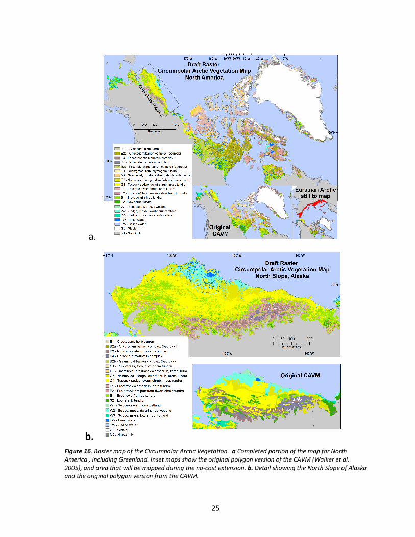
Raster-based circumpolar Arctic vegetation map (Raynolds and Walker)
Introduction: Task 1.3a proposed the creation of a raster version of the widely used Circumpolar Arctic Vegetation Map polygon map (CAVM Team 2003). The raster version would have the same circumpolar legend, but provide greater spatial resolution, with 1-km pixels. The raster CAVM would allow incorporation of recent mapping data from the Arctic
Figure 15. Biweekly maxNDVI average (green bar) and trend (grey bar) over the period 1999-2015.
24
(local vegetation, elevation, climate, etc.), and provide a format that is more compatible with satellite data sets and modeling efforts.
Methods: 1. Divide the arctic into regions that have similar geologic histories. These are similar to the phytogeographic areas shown the CAVM, as plant distribution in the Arctic is largely controlled by glacial history.
2. Conduct unsupervised classifications by region, using data from AVHRR (Band 1, Band 2, NDVI), MODIS (Band 1, Band 2, NDVI), and elevation. The AVHRR data are from a circumpolar composite used to create the original CAVM (Walker et al. 2005). The data are at 1-km resolution, and are a maximum NDVI composite from 1993 and 1995. The MODIS data are at 250-m resolution, resampled to 1 km, from a composite created for the Circumpolar Boreal Mapping Project (Selkowitz 2010). The elevation data are at 1-km resolution, from the Digital Chart of the World (ESRI 1993).
3. Assign unsupervised classification clusters to CAVM units. This modeling process relies on vegetation data from ground studies, existing vegetation maps, and ancillary data such as climate, subsurface, surface and glacial geology. In addition, the characteristics of the clusters, summarized as mean NDVI (both AVHRR and MODIS) and elevation are considered. Clusters can be further subdivided as needed based on these characteristics.
4. Review mapping for consistency between regions and with vegetation unit definitions.
5. Send preliminary maps to experts for review.
6. Final revision and joining of regions to create one dataset, the Raster CAVM.
Progress: We have applied steps 1-3 of the method to all of North American, including Greenland (11 separate analyses, Fig. 16a). We are in the process of step 4, reviewing the consistency of the mapping within North America. As expected, the new map shows the same broad patterns as the original CAVM, but is able to distinguish greater spatial heterogeneity at finer scales as demonstrated for northern Alaska in Fig. 16b. The early results from the map were presented at the 2016 Circumpolar Remote Sensing Conference (Raynolds et al. 2016).
References: ESRI. 1993. Digital Chart of the World. Environmental Systems Research Institute, Inc., Redlands, CA. Selkowitz, D. J. 2010. Selection of the CBVM base map: Review of MODIS images Circumpolar Boreal
Vegetation Map Workshop, Helsinki, Finland. *Raynolds, M. K., & Walker, D. A. (2016b). Increased wetness confounds Landsat-derived NDVI trends in the
central Alaska North Slope region, 1985–2011. Environmental Research Letters, 11(8), 085004. http://doi.org/10.1088/1748-9326/11/8/085004
Walker, D. A., M. K. Raynolds, F. J. A. Daniels, E. Einarsson, A. Elvebakk, W. A. Gould, A. E. Katenin, S. S. Kholod, C. J. Markon, E. S. Melnikov, N. G. Moskalenko, S. S. Talbot, B. A. Yurtsev, and CAVM Team. 2005. The Circumpolar Arctic Vegetation Map. Journal of Vegetation Science 16:267-282.
25
a.
b.
Figure 16. Raster map of the Circumpolar Arctic Vegetation. a Completed portion of the map for North America , including Greenland. Inset maps show the original polygon version of the CAVM (Walker et al. 2005), and area that will be mapped during the no-cost extension. b. Detail showing the North Slope of Alaska and the original polygon version from the CAVM.
26
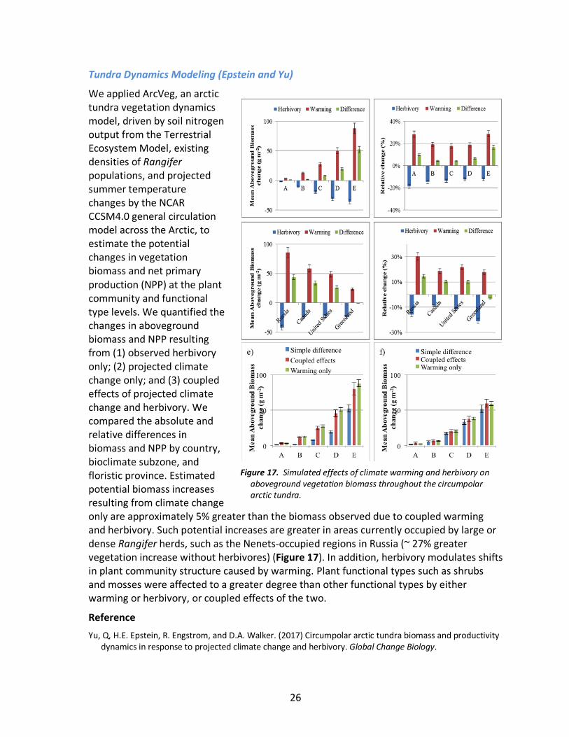
Tundra Dynamics Modeling (Epstein and Yu)
We applied ArcVeg, an arctic tundra vegetation dynamics model, driven by soil nitrogen output from the Terrestrial Ecosystem Model, existing densities of Rangifer populations, and projected summer temperature changes by the NCAR CCSM4.0 general circulation model across the Arctic, to estimate the potential changes in vegetation biomass and net primary production (NPP) at the plant community and functional type levels. We quantified the changes in aboveground biomass and NPP resulting from (1) observed herbivory only; (2) projected climate change only; and (3) coupled effects of projected climate change and herbivory. We compared the absolute and relative differences in biomass and NPP by country, bioclimate subzone, and floristic province. Estimated potential biomass increases resulting from climate change only are approximately 5% greater than the biomass observed due to coupled warming and herbivory. Such potential increases are greater in areas currently occupied by large or dense Rangifer herds, such as the Nenets-occupied regions in Russia (~ 27% greater vegetation increase without herbivores) (Figure 17). In addition, herbivory modulates shifts in plant community structure caused by warming. Plant functional types such as shrubs and mosses were affected to a greater degree than other functional types by either warming or herbivory, or coupled effects of the two.
Reference Yu, Q, H.E. Epstein, R. Engstrom, and D.A. Walker. (2017) Circumpolar arctic tundra biomass and productivity
dynamics in response to projected climate change and herbivory. Global Change Biology.
Figure 17. Simulated effects of climate warming and herbivory on
aboveground vegetation biomass throughout the circumpolar arctic tundra.
27
COMPONENT 2: SYNTHESIS OF SOCIAL-ECOLOGICAL DATA (KOFINAS, FORBES, RAYNOLDS AND KUMPULA)
Comparison of infrastructure trends in the Prudhoe Bay oilfield and Bovanenkovo gasfield (Kumpula and Raynolds)
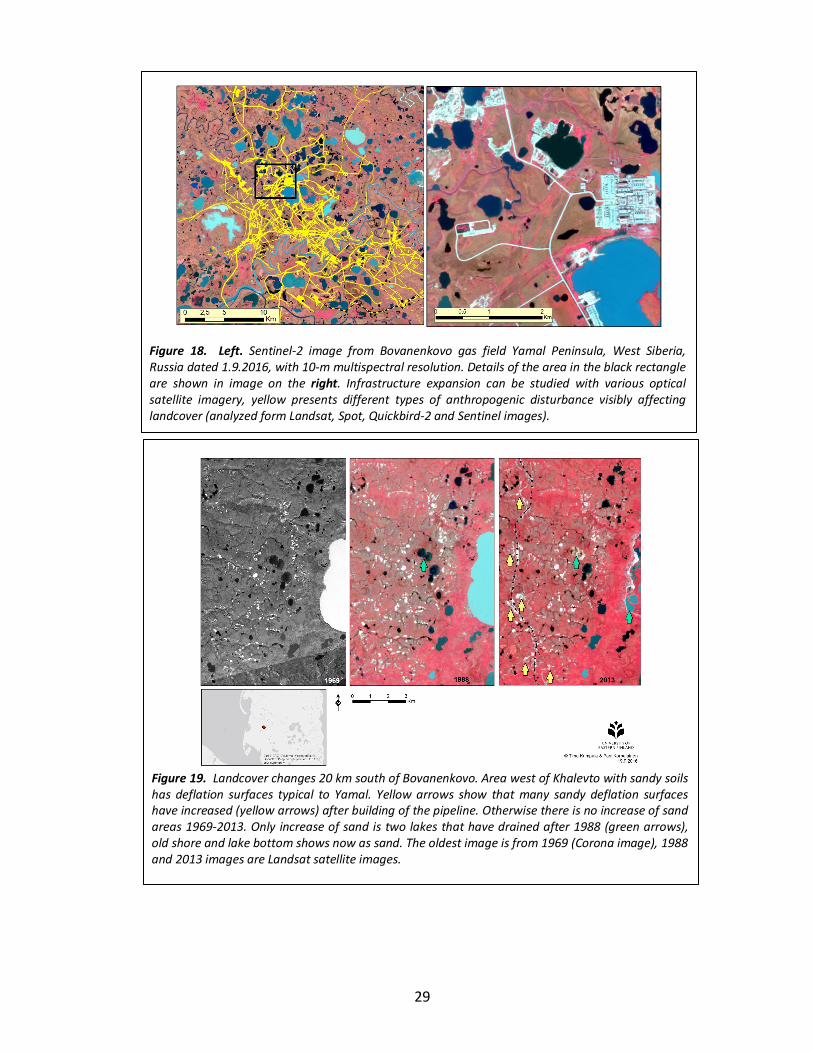
Introduction: Task 2.1a proposed to examine the cumulative effects of climate and infrastructure in the Bovanenkovo and Prudhoe Bay oil fields to the Nenets and Iñupiat cultures. Part of the analysis includes a time-series analysis of infrastructure and landscape changes using Landsat data and GIS databases.
Methods: For the Bovanenkovo Gas Field, we have created Landsat mosaics from years 1988/1989 and 2013/2014 from the whole Yamal peninsula to examine the cumulative effects of climate and infrastructure to the Nenets reindeer herding. The database has been updated to September 2016 using the latest Landsat 8 and Sentinel-2 imagery (Fig 18). Examination of infrastructure for the entire 2,052 km2 Bovanenkovo gas field is necessarily based on lower resolution imagery, such as Landsat (MSS, TM, ETM+, OLI), SPOT). We were also able to include some Very High Resolution imagery from part of the area of interest (Quickbird-2 and Worldview-2) to our analysis, which improved the interpretation of coarser imagery. Also new SENTINEL-2 data with 10 m multispectral resolution proved to be very useful. Two satellite imagery mosaics were built with ArcGIS software. First, 18 Landsat 4 & 5 scenes were selected from 1987–1990. One scene from 1987, 4 from 1988, 1 from 1989 and 12 from 1990. Dates of all scenes are between 11 July and 22 August. For the Landsat 8 mosaic 22 scenes were selected from 2013–2014. 20 scenes are from 2013 and 2 from 2014. Dates for Landsat 8 scenes are from 12 July to 13 August. The study area covers the whole Yamal Peninsula, starting North from Ob delta and including Ostrov Belyy in the far North. Size of the area is 124 425 km2. Mosaic dataset tool in ArcGIS was used to build the mosaics. Apparent reflectance function was applied to all scenes before exporting final mosaic. After this both mosaics were classified to 5 classes with isocluster unsupervised classification method. All the inland lakes were separated from the classification as a raster image. This raster was further processed with 5 x 5 focal statistics tool to clean single pixels and small rivers. Lakes smaller than 1.08 ha (twelve 30 x 30-m pixels) were removed. A related study of active-layer detachments (ALDs), the methods used included visual interpretation and comparison of satellite images and normalised difference vegetation index (NDVI) analysis of very high resolution data. In addition, 12 m resolution digital elevation model (DEM) derived from TerraSAR-X data was used to investigate the topography impact on landslide occurrence. Analysis of the DEM showed that slope aspect does not affect occurrence of landslides in the study area, and that large ALDs do not need steep slopes angles to occur. Analysing multispectral optical satellite imagery was found most useful as a method for mapping the landslides. Landsat TM and SPOT images were useful for mapping extensive, < 20 years old ALDs, whereas images from QuickBird-2 and WorldView-2 performed well in detection of little vegetated landslide surfaces even 24 years after a landslide. Very-high-resolution images were good for monitoring small-scale changes on shear surfaces and development of retrogressive thaw slumps. The NDVI-analysis revealed decrease of bare and semi-bare surface from
28
1.73 km2 to 0.71 km2 between years 2004 and 2013, showing well the development of revegetation.
In the Prudhoe Bay field we examined changes using Landsat TM and ETM+ data between 1985 and 2011 in the central Alaska North Slope region, where the vegetation and landscapes are relatively well-known and mapped. We calculated trends in the normalized difference vegetation index (NDVI) and tasseled-cap transformation indices, and related them to high-resolution aerial photographs, ground studies, and vegetation maps.
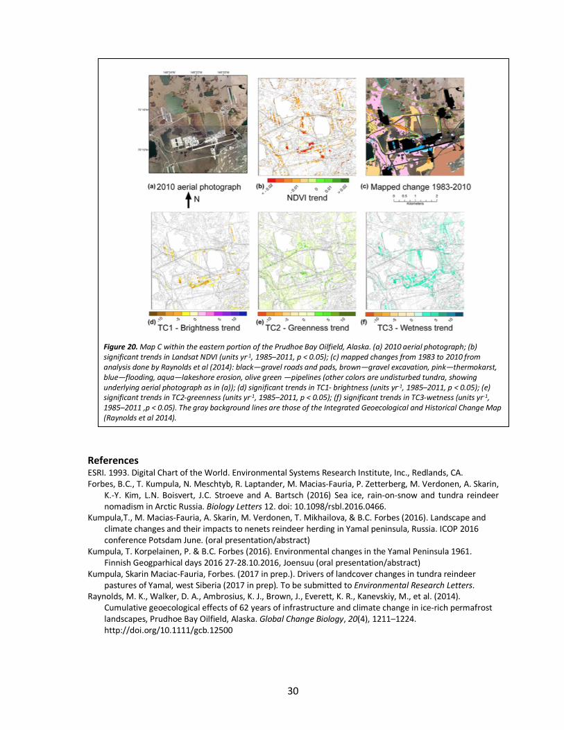
Progress: Growth of the Bovanenkovo gas-field has slowed since the most active construction phase in 2007-2014. The BGF was opened for production in late 2012. However, despite of the current situation Bovanenkovo gas field is expected to expand significantly in the future. Officially the gas field covers an area of 2052 km2. Our actual study area is larger than BGF, namely we are focusing to Yarsalinksi sovhoze’s summer pastures located on central Yamal Peninsula. The total area of investigation is about 8500 km2. We have prepared manuscript to be submitted to Environmental Research Letters in late march 2017. Title of manuscript is Drivers of landcover changes in tundra reindeer pastures of Yamal, west Siberia (Kumpula, Skarin Macias-Fauria, Forbes 2017 in prep). This paper will document BGF development and other land-use changes in the research area (ALDs, lake draining, shrubification). Special focus is on how reindeer pastures are now under strong pressures, and try to understand how reindeer herders can adapt to climate and anthropogenic pressures. Figure 19 shows how the image database is being used to identify areas of enhanced wind erosion triggered by construction of the Obskaya-Bovanenkovo railroad in the sandy upland landscapes. This paper will also include data from interviews of the Nenets herders. A study of active layer detachment slides is progressing well, results are ready and we are preparing manuscript (M. Verdonen, T. Kumpula, P. Korpelainen, B.C. Forbes 2017 in prep.).
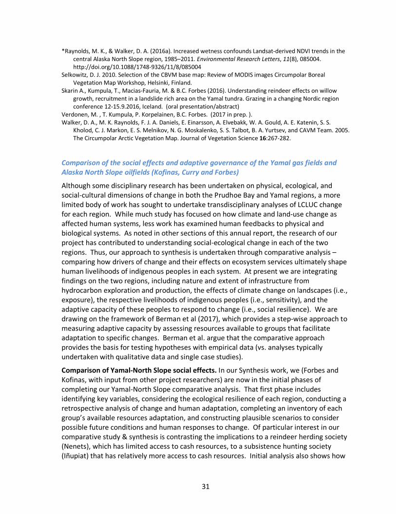
At Prudhoe Bay, we have completed the analysis of vegetation and landscape change and published two papers (Raynolds et al. 2014, 2016). The 2014 work was reported in earlier annual reports, the 2016 publication showed that significant, mostly negative, changes in NDVI occurred in 7.3% of the area, with greater change in aquatic and barren types. Large reflectance changes due to erosion, deposition and lake drainage were evident. Oil industry-related changes such as construction of artificial islands, roads, and gravel pads were also easily identified (Fig. 20). Regional trends showed decreases in NDVI for most vegetation types, but increases in tasseled-cap greenness (56% of study area, greatest for vegetation types with high shrub cover) and tasseled-cap wetness (11% of area), consistent with documented degradation of polygon ice wedges, indicating that increasing cover of water may be masking increases in vegetation when summarized using the water-sensitive NDVI.
29
Figure 18. Left. Sentinel-2 image from Bovanenkovo gas field Yamal Peninsula, West Siberia, Russia dated 1.9.2016, with 10-m multispectral resolution. Details of the area in the black rectangle are shown in image on the right. Infrastructure expansion can be studied with various optical satellite imagery, yellow presents different types of anthropogenic disturbance visibly affecting landcover (analyzed form Landsat, Spot, Quickbird-2 and Sentinel images).
Figure 19. Landcover changes 20 km south of Bovanenkovo. Area west of Khalevto with sandy soils has deflation surfaces typical to Yamal. Yellow arrows show that many sandy deflation surfaces have increased (yellow arrows) after building of the pipeline. Otherwise there is no increase of sand areas 1969-2013. Only increase of sand is two lakes that have drained after 1988 (green arrows), old shore and lake bottom shows now as sand. The oldest image is from 1969 (Corona image), 1988 and 2013 images are Landsat satellite images.
30
References ESRI. 1993. Digital Chart of the World. Environmental Systems Research Institute, Inc., Redlands, CA. Forbes, B.C., T. Kumpula, N. Meschtyb, R. Laptander, M. Macias-Fauria, P. Zetterberg, M. Verdonen, A. Skarin,
K.-Y. Kim, L.N. Boisvert, J.C. Stroeve and A. Bartsch (2016) Sea ice, rain-on-snow and tundra reindeer nomadism in Arctic Russia. Biology Letters 12. doi: 10.1098/rsbl.2016.0466.
Kumpula,T., M. Macias-Fauria, A. Skarin, M. Verdonen, T. Mikhailova, & B.C. Forbes (2016). Landscape and climate changes and their impacts to nenets reindeer herding in Yamal peninsula, Russia. ICOP 2016 conference Potsdam June. (oral presentation/abstract)
Kumpula, T. Korpelainen, P. & B.C. Forbes (2016). Environmental changes in the Yamal Peninsula 1961. Finnish Geogparhical days 2016 27-28.10.2016, Joensuu (oral presentation/abstract)
Kumpula, Skarin Maciac-Fauria, Forbes. (2017 in prep.). Drivers of landcover changes in tundra reindeer pastures of Yamal, west Siberia (2017 in prep). To be submitted to Environmental Research Letters.
Raynolds, M. K., Walker, D. A., Ambrosius, K. J., Brown, J., Everett, K. R., Kanevskiy, M., et al. (2014). Cumulative geoecological effects of 62 years of infrastructure and climate change in ice-rich permafrost landscapes, Prudhoe Bay Oilfield, Alaska. Global Change Biology, 20(4), 1211–1224. http://doi.org/10.1111/gcb.12500
Figure 20. Map C within the eastern portion of the Prudhoe Bay Oilfield, Alaska. (a) 2010 aerial photograph; (b) significant trends in Landsat NDVI (units yr-1, 1985–2011, p < 0.05); (c) mapped changes from 1983 to 2010 from analysis done by Raynolds et al (2014): black—gravel roads and pads, brown—gravel excavation, pink—thermokarst, blue—flooding, aqua—lakeshore erosion, olive green —pipelines (other colors are undisturbed tundra, showing underlying aerial photograph as in (a)); (d) significant trends in TC1- brightness (units yr-1, 1985–2011, p < 0.05); (e) significant trends in TC2-greenness (units yr-1, 1985–2011, p < 0.05); (f) significant trends in TC3-wetness (units yr-1, 1985–2011 ,p < 0.05). The gray background lines are those of the Integrated Geoecological and Historical Change Map (Raynolds et al 2014).
31
*Raynolds, M. K., & Walker, D. A. (2016a). Increased wetness confounds Landsat-derived NDVI trends in the central Alaska North Slope region, 1985–2011. Environmental Research Letters, 11(8), 085004. http://doi.org/10.1088/1748-9326/11/8/085004
Selkowitz, D. J. 2010. Selection of the CBVM base map: Review of MODIS images Circumpolar Boreal Vegetation Map Workshop, Helsinki, Finland.
Skarin A., Kumpula, T., Macias-Fauria, M. & B.C. Forbes (2016). Understanding reindeer effects on willow growth, recruitment in a landslide rich area on the Yamal tundra. Grazing in a changing Nordic region conference 12-15.9.2016, Iceland. (oral presentation/abstract)
Verdonen, M. , T. Kumpula, P. Korpelainen, B.C. Forbes. (2017 in prep. ). Walker, D. A., M. K. Raynolds, F. J. A. Daniels, E. Einarsson, A. Elvebakk, W. A. Gould, A. E. Katenin, S. S.
Kholod, C. J. Markon, E. S. Melnikov, N. G. Moskalenko, S. S. Talbot, B. A. Yurtsev, and CAVM Team. 2005. The Circumpolar Arctic Vegetation Map. Journal of Vegetation Science 16:267-282.
Comparison of the social effects and adaptive governance of the Yamal gas fields and Alaska North Slope oilfields (Kofinas, Curry and Forbes)
Although some disciplinary research has been undertaken on physical, ecological, and social-cultural dimensions of change in both the Prudhoe Bay and Yamal regions, a more limited body of work has sought to undertake transdisciplinary analyses of LCLUC change for each region. While much study has focused on how climate and land-use change as affected human systems, less work has examined human feedbacks to physical and biological systems. As noted in other sections of this annual report, the research of our project has contributed to understanding social-ecological change in each of the two regions. Thus, our approach to synthesis is undertaken through comparative analysis – comparing how drivers of change and their effects on ecosystem services ultimately shape human livelihoods of indigenous peoples in each system. At present we are integrating findings on the two regions, including nature and extent of infrastructure from hydrocarbon exploration and production, the effects of climate change on landscapes (i.e., exposure), the respective livelihoods of indigenous peoples (i.e., sensitivity), and the adaptive capacity of these peoples to respond to change (i.e., social resilience). We are drawing on the framework of Berman et al (2017), which provides a step-wise approach to measuring adaptive capacity by assessing resources available to groups that facilitate adaptation to specific changes. Berman et al. argue that the comparative approach provides the basis for testing hypotheses with empirical data (vs. analyses typically undertaken with qualitative data and single case studies).
Comparison of Yamal-North Slope social effects. In our Synthesis work, we (Forbes and Kofinas, with input from other project researchers) are now in the initial phases of completing our Yamal-North Slope comparative analysis. That first phase includes identifying key variables, considering the ecological resilience of each region, conducting a retrospective analysis of change and human adaptation, completing an inventory of each group’s available resources adaptation, and constructing plausible scenarios to consider possible future conditions and human responses to change. Of particular interest in our comparative study & synthesis is contrasting the implications to a reindeer herding society (Nenets), which has limited access to cash resources, to a subsistence hunting society (Iñupiat) that has relatively more access to cash resources. Initial analysis also shows how
32
geography matters, with the Nenets having limited alternative (i.e. more constrained) landscapes for land use, while Inupiat, who have been mostly displaced from the North Slope oil fields, have a greater set of alternative land-use options. Possible futures of expanded oil development on North Slope Alaska may modify that advantage. Comparing institutions and the rights afforded to indigenous people in each region, key resources for human adaptation, shows the high reliance of Nenets herders on informal institutions (policies made by industry that is sympathetic to indigenous lifeways) and Inupiat peoples of the North Slope who have significant political power through NEPA and the Home Rule policies of the State of Alaska.
Adaptive governance. The concept of adaptive governance expands the focus of adaptive management to include the broader social contexts that enable the management of complex adaptive systems such as the Alaskan Arctic. This study examines adaptive governance in practice concerning the cumulative effects of climate change and resource development in Northern Alaska, focusing on knowledge and decision-making processes undertaken by a network of actors, organizations, and institutions at regional, state, and federal scales. To this end, semi-structured interviews are being conducted with upper level managers representing entities with responsibility for land and resource management in the region to gain an understanding of the quality of transdisciplinary interactions between these actors as well as the benefits and drawbacks of transdisciplinary knowledge processes involving the creation, use, and dissemination of information for decision-making purposes. To date, 15 interviews have been conducted with upper level managers from BP, a multi-national oil company with extensive operations in the North Slope. Interviews with representatives from federal, state, and Alaska Native entities with responsibility for land and resource management across the North Slope will be ongoing throughout 2017. As the BP interviews are being analyzed, some initial findings include a perceived lack of collaboration between industry and academia with some respondents having strong feelings that there should be more collaboration while others do not see much value in further collaboration given the differing interests of each group. Participants characterized interactions between industry and public agencies as being primarily driven by regulations. Also, participants noted that there is currently little collaboration with competitors (other large oil companies) though some believed that this sort of collaboration could benefit current and future data collection and monitoring initiatives in the North Slope.
References: *Berman, M., Kofinas, G., and BurnSilver, S. (2017). Measuring Community Adaptive and Transformative
Capacity in the Arctic Context, in Northern Sustainabilities, Understanding and Addressing Change in the Circumpolar World. Gail Fondahl and Gary Wilson (eds.), Heidelberg: Springer. 59-76.
Toward sustainable Arctic development in a changing climate (Walker, Kofinas, Kumpula, Forbes, and Peirce)
The Rapid Arctic Transitions due to Infrastructure and Climate (RATIC) initiative was proposed as part of our Yamal Synthesis project as a means to share new ideas and methods to facilitate the best practices for assessing, responding to, and adaptively
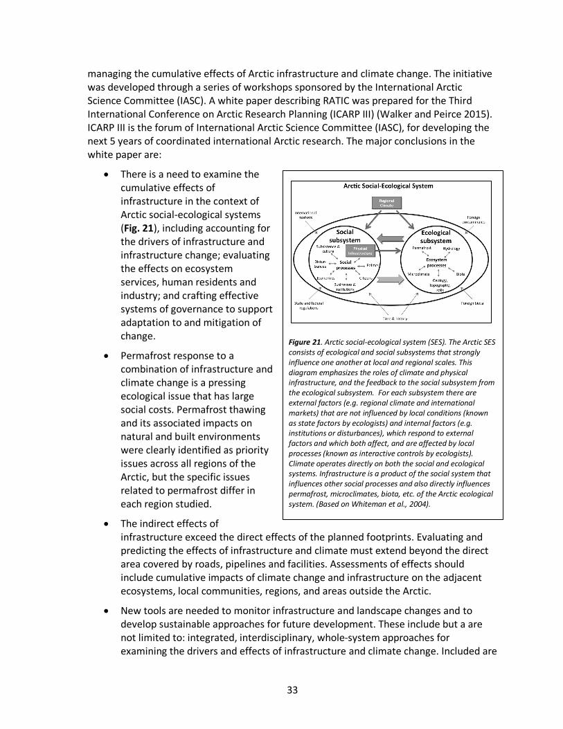
33
managing the cumulative effects of Arctic infrastructure and climate change. The initiative was developed through a series of workshops sponsored by the International Arctic Science Committee (IASC). A white paper describing RATIC was prepared for the Third International Conference on Arctic Research Planning (ICARP III) (Walker and Peirce 2015). ICARP III is the forum of International Arctic Science Committee (IASC), for developing the next 5 years of coordinated international Arctic research. The major conclusions in the white paper are:
• There is a need to examine the cumulative effects of infrastructure in the context of Arctic social-ecological systems (Fig. 21), including accounting for the drivers of infrastructure and infrastructure change; evaluating the effects on ecosystem services, human residents and industry; and crafting effective systems of governance to support adaptation to and mitigation of change.
• Permafrost response to a combination of infrastructure and climate change is a pressing ecological issue that has large social costs. Permafrost thawing and its associated impacts on natural and built environments were clearly identified as priority issues across all regions of the Arctic, but the specific issues related to permafrost differ in each region studied.
• The indirect effects of infrastructure exceed the direct effects of the planned footprints. Evaluating and predicting the effects of infrastructure and climate must extend beyond the direct area covered by roads, pipelines and facilities. Assessments of effects should include cumulative impacts of climate change and infrastructure on the adjacent ecosystems, local communities, regions, and areas outside the Arctic.
• New tools are needed to monitor infrastructure and landscape changes and to develop sustainable approaches for future development. These include but a are not limited to: integrated, interdisciplinary, whole-system approaches for examining the drivers and effects of infrastructure and climate change. Included are
Figure 21. Arctic social-ecological system (SES). The Arctic SES consists of ecological and social subsystems that strongly influence one another at local and regional scales. This diagram emphasizes the roles of climate and physical infrastructure, and the feedback to the social subsystem from the ecological subsystem. For each subsystem there are external factors (e.g. regional climate and international markets) that are not influenced by local conditions (known as state factors by ecologists) and internal factors (e.g. institutions or disturbances), which respond to external factors and which both affect, and are affected by local processes (known as interactive controls by ecologists). Climate operates directly on both the social and ecological systems. Infrastructure is a product of the social system that influences other social processes and also directly influences permafrost, microclimates, biota, etc. of the Arctic ecological system. (Based on Whiteman et al., 2004).
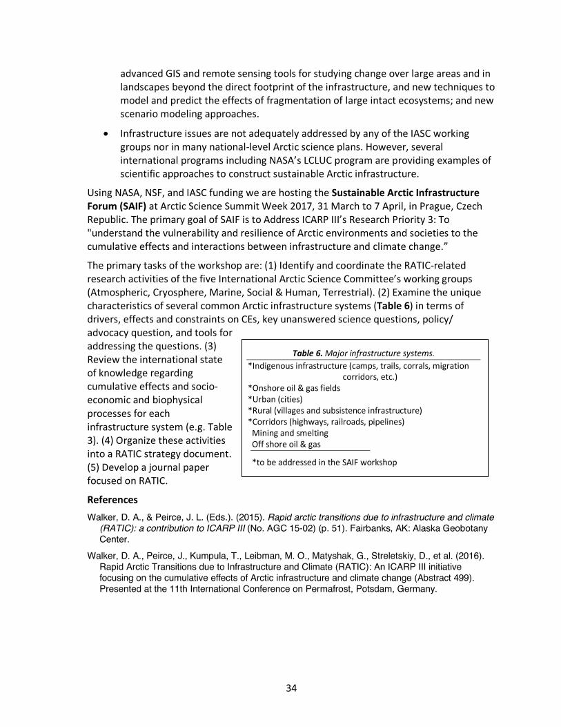
34
advanced GIS and remote sensing tools for studying change over large areas and in landscapes beyond the direct footprint of the infrastructure, and new techniques to model and predict the effects of fragmentation of large intact ecosystems; and new scenario modeling approaches.
• Infrastructure issues are not adequately addressed by any of the IASC working groups nor in many national-level Arctic science plans. However, several international programs including NASA’s LCLUC program are providing examples of scientific approaches to construct sustainable Arctic infrastructure.
Using NASA, NSF, and IASC funding we are hosting the Sustainable Arctic Infrastructure Forum (SAIF) at Arctic Science Summit Week 2017, 31 March to 7 April, in Prague, Czech Republic. The primary goal of SAIF is to Address ICARP III’s Research Priority 3: To "understand the vulnerability and resilience of Arctic environments and societies to the cumulative effects and interactions between infrastructure and climate change.”
The primary tasks of the workshop are: (1) Identify and coordinate the RATIC-related research activities of the five International Arctic Science Committee’s working groups (Atmospheric, Cryosphere, Marine, Social & Human, Terrestrial). (2) Examine the unique characteristics of several common Arctic infrastructure systems (Table 6) in terms of drivers, effects and constraints on CEs, key unanswered science questions, policy/ advocacy question, and tools for addressing the questions. (3) Review the international state of knowledge regarding cumulative effects and socio-economic and biophysical processes for each infrastructure system (e.g. Table 3). (4) Organize these activities into a RATIC strategy document. (5) Develop a journal paper focused on RATIC.
References Walker, D. A., & Peirce, J. L. (Eds.). (2015). Rapid arctic transitions due to infrastructure and climate
(RATIC): a contribution to ICARP III (No. AGC 15-02) (p. 51). Fairbanks, AK: Alaska Geobotany Center.
Walker, D. A., Peirce, J., Kumpula, T., Leibman, M. O., Matyshak, G., Streletskiy, D., et al. (2016). Rapid Arctic Transitions due to Infrastructure and Climate (RATIC): An ICARP III initiative focusing on the cumulative effects of Arctic infrastructure and climate change (Abstract 499). Presented at the 11th International Conference on Permafrost, Potsdam, Germany.
Table 6. Major infrastructure systems. *Indigenous infrastructure (camps, trails, corrals, migration
corridors, etc.) *Onshore oil & gas fields *Urban (cities) *Rural (villages and subsistence infrastructure) *Corridors (highways, railroads, pipelines)
Mining and smelting Off shore oil & gas
*to be addressed in the SAIF workshop
35
Request for no-cost extension We are requesting a no-cost extension for the Yamal Synthesis. This is needed for three primary reasons.
1. Several of the interdisciplinary papers require additional work before they are submitted for publication.
2. The SAIF workshop will occur after the end date of our project, and will require synthesis of the results.
3. We need the extra time to develop three grand synthesis products with the remaining funds:
a. A major synthetic paper that uses remote sensing products to compare the cumulative socio-ecological effects of development on Alaska’s North Slope with the Yamal region.
b. A synthesis paper describing the RATIC initiative and results from the SAIF workshop.
c. A Eurasia Arctic Transect ebook that brings together all the aspects of the EAT in a single volume. The ebook format will allow us to archive in one place the most important products of the project along with a brief synthetic introduction that describes the major accomplishments along with stories and photos from the expeditions. Each proposed section will include a relatively brief overview of a specific component of the research, followed by links to the major publications and other products. Cost of publishing the ebook will be relatively low because it will mostly accomplished by Jana Peirce, the web designer and editor of several of Alaska Geobotany Center’s publications.
Proposed outline for an EAT ebook Land-cover and Land-Use Change along the Eurasia Arctic Transect
Results and synthesis of the International Polar Year Greening of the Arctic project’s expeditions to the Yamal Peninsula and Franz Jozef Land 2007-2012
Edited by D.A. Walker & J. Peirce
Section 1. Introduction (Walker)
1.1. IPY AND GREENING OF THE ARCTIC BACKGROUND (WALKER, 3 PAGES + 2-3 FIGURE) Walker, D. A., Epstein, H. E., Bhatt, U. S., Leibman, M. O., Forbes, B. C., Romanovsky, V. E., et al. (2012). Greening of the
Arctic Project (IPY-GOA, project ID 569). Presented at the From Knowledge to Action, 2012 IPY Conference. Montreal, CA http://www.ipy2012montreal.ca/
Krupnik, I., Allison, I., Bell, R., Cutler, P., Hik, D., Lopez-Martinez, J., et al. (Eds.). (2011). Understanding earth's polar challenges: International Polar Year 2007-2008: summary by the IPY Joint Committee. Rovaniemi, FI/Edmonton, Alberta, CA/ICSU/WMO Joint Committee for International Polar Year 2007-2008: University of the Arctic/CCI Press.
Other material from the original proposal.
1.2. SCIENTIFIC QUESTIONS AND PROJECT COMPONENTS (WALKER, 3 PAGES +1-2 FIGURES) Mostly material from the original proposal.
1.3. THE YAMAL PENINSULA OVERVIEW AND THE EAT STUDY LOCATIONS (WALKER AND OREKHOV, 5-10 PAGES + ABOUT 10 PHOTOS AND MAPS) Material from the 2007-2011 expedition data reports
Much of this could come from a paper the vegetation paper currently in progress
36
Extensive already-written material at the Earth Cryosphere Institute, Moscow.
1.4. LOGISTICS OF THE PROJECT (WALKER, FROST, LEIBMAN, OREKHOV, 5 PAGES + ABOUT 5-6 PHOTOS AND MAPS, TRACING EACH OF THE EXPEDITIONS) Maps and diagrams of the 2007-2011 expeditions
Frost slide show of FJL expedition
Section 2. Permafrost, active layer, landslides, and craters (Leibman, Romanovsky, Khumotov, Orekhov)
2.1. PERMAFROST BOREHOLES (ROMONOVSKY, OREKHOV)
2.1.1. Overview (Romanovsky, 2-3 pages)
2.1.2. Published papers Papers published in Russian regarding the Yamal-FJL borehole information
2.2. ACTIVE LAYERS 2.2.1. Overview (Marina, 2-3 pages)
2.2.2. Published papers Leibman, M. O., Epstein, H. E., Khomutov, A. V., Moskalenko, N. G., & Walker, D. A. (2008). Relation of active layer depth
to vegetation on the central Yamal Peninsula, Russia (Vol. Extended Abstracts, pp. 177–178). Presented at the Ninth International Conference on Permafrost, Fairbanks, AK.
Leibman, M. O., Khumutov, A. V., Orechov, P. T., Khitun, O. V., Epstein, H., Frost, G. V., & Walker, D. A. (2012). Gradient of seasonal thaw depth along the Yamal transect (pp. 237–242). Presented at the Proceeding of the Tenth International Conference on Permafrost, Salekhard, Yamal-Nenets Automomous District, Russia, June 25-29, 2012.
2.3 LANDSLIDES (LEIBMAN, KHOMUTOV, 4-5 PAGES) 2.3.1. Overview (Leibman)
2.3.2 PUBLISHED ARTICLES:
LEIBMAN, M., KHOMUTOV, A., GUBARKOV, A., MULLANUROV, D., & DVORNIKOV, Y. (2015). THE RESEARCH STATION “VASKINY DACHI,” CENTRAL YAMAL, WEST SIBERIA, RUSSIA - A REVIEW OF 25 YEARS OF PERMAFROST STUDIES. FENNIA, 193, 3–30. LEIBMAN, M. O., GUBARKOV, A. A., & KHOMUTOV, A. V. (2012). RESEARCH STATION VASKINY DACHI: TICOP EXCURSION GUIDEBOOK: TENTH INTERNATIONAL CONFERENCE ON PERMAFROST TICOP: RESOURCES AND RISKS OF PERMAFROST AREAS IN A CHANGING WORLD (PP. 1–50). TYUMEN: PECHATNIK, RUSSIA: NORTH PRESS. LEIBMAN, M. O., KHUMUTOV, A. V., ORECHOV, P. T., KHITUN, O. V., EPSTEIN, H., FROST, G. V., & WALKER, D. A. (2012). GRADIENT OF SEASONAL THAW DEPTH ALONG THE YAMAL TRANSECT (PP. 237–242). PRESENTED AT THE PROCEEDING OF THE TENTH INTERNATIONAL CONFERENCE ON PERMAFROST, SALEKHARD, YAMAL-NENETS AUTOMOMOUS DISTRICT, RUSSIA, JUNE 25-29, 2012. LEIBMAN, M., A. KHOMUTOV, AND A. KIZYAKOV. 2014B. CRYOGENIC LANDSLIDES IN THE WEST-SIBERIAN PLAIN OF RUSSIA: CLASSIFICATION, MECHANISMS, AND LANDFORMS. PAGES 143–162 IN W. SHAN, Y. GUO, F. WANG, H. MARUI, AND A. STROM, EDITORS. LANDSLIDES IN COLD REGIONS IN THE CONTEXT OF CLIMATE CHANGE, ENVIRONMENTAL SCIENCE AND ENGINEERING. SPRINGER INTERNATIONAL PUBLISHING, CHAM. Khomutov, A., & Leibman, M. (2013). Assessment of Landslide Hazards in a Typical Tundra of Central Yamal, Russia. In W.
Shan, Y. Guo, F. Wang, H. Marui, & A. Strom (Eds.), Landslides in Cold Regions in the Context of Climate Change (pp. 271–290). Cham: Springer International Publishing. http://doi.org/10.1007/978-3-319-00867-7_20
37
2.4. YAMAL CRATERS (LEIBMAN)
2.4.1. Overview (Marina, 1-2 pages)
2.4.2 Published articles
LEIBMAN, M. O., A. I. KIZYAKOV, A. V. PLEKHANOV, AND I. D. STRELETSKAYA. 2014A. NEW PERMAFROST FEATURE: DEEP CRATER IN CENTRAL YAMAL, WEST SIBERIA, RUSSIA AS A RESPONSE TO LOCAL CLIMATE FLUCTUATIONS. GEOGRAPHY, ENVIRONMENT, SUSTAINABILITY 7:68–80.
Section 3. Vegetation and soils along the EAT (Walker, Matyshak et al.)
3.1. OVERVIEW (WALKER AND MATYSHAK, 4-5 PAGES) 3.2. PUBLISHED ARTICLES
Vegetation:
Walker, D. A., Šibík, J., Chasnikova, S., Matyshak, G., Epstein, H. E., Ermokhina, K., et al. (2017, in prep.). Vegetation on loamy and sandy soils along an Arctic tundra bioclimate transect, Yamal Peninsula and Franz Josef Land, Russia. Applied Vegetation Science.
Walker, D.A., Matyshak, G., Frost, G.V., Zhurbenko, M., Afonina, O. 2012. High cover, biomass, and NDVI of biological soil crusts on Hayes Island, Franz Josef Land, Russia. Tenth International Conference on Permafrost. Salekhard, Russia June 25-29.
Biomass, LAI, NDVI:
Epstein, H. E., I. Myers-Smith, and D. A. Walker. 2013. Recent dynamics of arctic and sub-arctic vegetation. Environmental Research Letters 8:015040.
Shrubification: Forbes, B. C., Fauria, M. M., & Zetterberg, P. (2010). Russian Arctic warming and “greening” are closely tracked by tundra
shrub willows. Global Change Biology, 1542-1554(5), 1542–1554. http://doi.org/10.1111/j.1365-2486.2009.02047.x Frost, G. V., Epstein, H. E., Walker, D. A., Matyshak, G., & Ermokhina, K. (2013). Patterned-ground facilitates shrub
expansion in Low Arctic tundra. Environmental Research Letters, 8(1), 015035. http://doi.org/10.1088/1748-9326/8/1/015035
Frost, G.V., Epstein, H.E., Walker, D.A. and Matyshak, G. 2016 (in prep). Changes to active-layer temperature after tall shrub expansion in arctic tundra. Ecosystems, in prep.
Soils: Matyshak, G. (EAT soil article in prep.) Matyshak, G.V., Goncharova, O.Y., Walker, D.A., Epstein, H.E., Moskalenko, N.G., and Shur, Y. 2015. Contrasting soil
thermal regimes in the forest-tundra transition near Nadym, West Siberia, Russia. Permafrost and Periglacial Processes 10.1002/ppp.1882.
Section 4. Remote Sensing and Greening dynamics (Epstein, Raynolds, Frost, and Bhatt)
4.1. OVERVIEW (EPSTEIN, RAYNOLDS, FROST, BHATT, KUMPULA, 4-5 PAGES) 4.2. PUBLISHED ARTICLES Walker, D. A., Leibman, M. O., Epstein, H. E., Forbes, B. C., Bhatt, U. S., Raynolds, M. K., et al. (2009). Spatial and temporal
patterns of greenness on the Yamal Peninsula, Russia: interactions of ecological and social factors affecting the Arctic normalized difference vegetation index. Environmental Research Letters, 4(4), 045004. http://doi.org/10.1088/1748-9326/4/4/045004
Frost, G. V., and H. E. Epstein. 2014. Tall shrub and tree expansion in Siberian tundra ecotones since the 1960s. Global Change Biology 20:1264–1277.
Frost, G. V., H. E. Epstein, and D. A. Walker. 2014. Regional and landscape-scale variability of Landsat-observed vegetation
38
dynamics in northwest Siberian tundra. Environmental Research Letters 9:025004 (11pp). http://doi.org/10.1111/gcb.12406 Macias-Fauria, M., Forbes, B. C., Zetterberg, P., & Kumpula, T. (2012). Eurasian Arctic greening reveals teleconnections
and the potential for structurally novel ecosystems. Nature Climate Change, 2(8), 613–618. http://doi.org/10.1038/nclimate1558
Section 5. Impacts of Yamal gas development (Kumpula, Forbes, Gary, 4-5 pages)
5.1. OVERVIEW (FORBES, KUMPULA) 5.2. PUBLISHED ARTICLES Forbes, B. C., Stammler, F., Kumpula, T., Meschtyb, N., Pajunen, A., & Kaarlejärvi, E. (2009). High resilience in the Yamal-
Nenets social-ecological system, West Siberian Arctic, Russia. Proceedings of the National Academy of Sciences, 106(52), 22041–22048. http://doi.org/10.1073/pnas.0908286106
Walker, D. A., Forbes, B. C., Leibman, M. O., Epstein, H. E., Bhatt, U. S., Comiso, J. C., et al. (2011). Cumulative effects of rapid land-cover and land-use changes on the Yamal Peninsula, Russia. In G. Gutman, A. Reissell, Reis (Eds.), Eurasian Arctic Land Cover and Land Use in a Changing Climate (pp. 207–236). Dordrecht: Springer.
Forbes, B. C. (2013). Cultural resilience of social-ecological systems in the Nenets and Yamal-Nenets Autonomous Okrugs, Russia: a focus on reindeer nomads of the tundra. Ecology and Society, 18(4), art36. http://doi.org/10.5751/ES-05791-180436
Kumpula, T., Forbes, B. C., & Stammler, F. (2006). Combining data from satellite images and reindeer herders in arctic petroleum development: the case of Yamal, West Siberia. Nordia Geographical Publications, 35(2), 17–30.
Kumpula, T., Forbes, B. C., Stammler, F., & Meschtyb, N. (2012). Dynamics of a Coupled System: Multi-Resolution Remote Sensing in Assessing Social-Ecological Responses during 25 Years of Gas Field Development in Arctic Russia. Remote Sensing, 4(4), 1046–1068. http://doi.org/10.3390/rs4041046
Kumpula, T., Pajunen, A., Kaarlejärvi, E., Forbes, B. C., & Stammler, F. (2011). Land use and land cover change in Arctic Russia: Ecological and social implications of industrial development. Global Environmental Change, 1–13. http://doi.org/10.1016/j.gloenvcha.2010.12.010
Section 6. Synthesis
6.1. PANARCTIC AND REGIONAL PATTERNS (WALKER, BHATT, EPSTEIN, RAYNOLDS, FOBES, KUMPULA, 4-5 PAGES)
6.1.1 Overview
6.1.2. Published articles Bhatt, U. S., Walker, D. A., Raynolds, M. K., Comiso, J. C., Epstein, H. E., Jia, G., et al. (2010). Circumpolar Arctic tundra
vegetation change is linked to sea ice decline. Earth Interact., Paper 14–008. Bhatt, U. S., Walker, D. A., Raynolds, M. K., Bieniek, P. A., Epstein, H. E., Comiso, J. C., et al. (2013). Recent declines in
warming and vegetation greening trends over pan-Arctic tundra. Remote Sensing, 5, 4229–4254. Bhatt, U. S., Walker, D. A., Walsh, J. E., Carmack, E. C., Frey, K. E., Meier, W. N., et al. (2014). Implications of Arctic sea ice
decline for the Earth system. Annual Review of Environment and Resources, 39, 57–89. Frost, G. V., & Epstein, H. E. (2014). Tall shrub and tree expansion in Siberian tundra ecotones since the 1960s. Global
Change Biology, 20, 1264. Raynolds et al. (2017 in prep.) Raster version of the CAVM, Forbes, B. C. (2013). Cultural resilience of social-ecological systems in the Nenets and Yamal-Nenets Autonomous Okrugs,
Russia: a focus on reindeer nomads of the tundra. Ecology and Society, 18(4), art36. http://doi.org/10.5751/ES-05791-180436
Forbes, B. C., Kumpula, T., Meschtyb, N., Laptander, R., Macias-Fauria, M., Zetterberg, P., et al. (2016). Sea ice, rain-on-snow and tundra reindeer nomadism in Arctic Russia. Biology Letters, 12(11), 20160466. http://doi.org/10.1098/rsbl.2016.0466
Walker, D. A., Forbes, B. C., Leibman, M. O., Epstein, H. E., Bhatt, U. S., Comiso, J. C., et al. (2011). Cumulative effects of rapid land-cover and land-use changes on the Yamal Peninsula, Russia. In G. Gutman, A. Reissell, Reis (Eds.), Eurasian Arctic Land Cover and Land Use in a Changing Climate (pp. 207–236). Dordrecht: Springer.